Embed Size (px)
Citation preview
DUKE ENVIRONMENTAL AND ENERGY ECONOMICS WORKING PAPER SERIESorganized by the
NICHOLAS INSTITUTE FOR ENVIRONMENTAL POLICY SOLUTIONSand the
DUKE UNIVERSITY ENERGY INITIATIVE
Geoengineering Coastlines? From Accidental to IntentionalMartin D. Smith*A. Brad Murray* Sathya Gopalakrishnan‡
Andrew G. Keeler,§
Craig E. Landry†
Dylan McNamara‡
Laura J. Moore**
Working Paper EE 14-02June 2014
*Nicholas School of the Environment, Duke University‡ Department of Agriculture, Environmental and Development Economics, Ohio State University§ University of North Carolina Coastal Studies Institute†Department of Economics, East Carolina University‡Department of Physics and Physical Oceanography, University of North Carolina, Wilmington**Department of Geological Sciences, University of North Carolina, Chapel Hill
The Duke Environmental and Energy Economics Working Paper Series provides a forum for Duke faculty working in environmental, resource, and energy economics to disseminate their research.
These working papers have not necessarily undergone peer review at the time of posting.
NICHOLAS INSTITUTEFOR ENVIRONMENTAL POLICY SOLUTIONS
Abstract
On developed coastlines, humans react to physical processes in coastal environments by stabilizing shorelines against chronic erosion and by taking measures to prevent destruction of coastal infrastructure during storms. While we are beginning to understand how physical processes affect human behavior, causality runs in the other direction as well. Over decades or longer, even localized anthropogenic shoreline manipulations influence large-‐scale patterns of coastline change as much as physical, climate-‐related forcing does. The long-‐range spatial and temporal spillovers of localized human actions in coastal environments, combined with widespread localized shoreline-‐stabilization and storm-‐protection efforts, amount to an unintentional geo-‐engineering of our coastlines. In essence, investments in coastal engineering fail to consider tradeoffs that can unfold over long temporal or large spatial scales. A more purposeful geo-‐engineering of coastlines requires a richer understanding of the two-‐way couplings between physical and human coastline dynamics, including efforts to reduce uncertainties in forecasting future scenarios for the coupled system. Steering toward preferred outcomes for our coastlines and coastal economies will involve coordination across local, state, and federal jurisdictions to mitigate spatial externalities that extend beyond local communities.
2
1. Introduction
Are humans geoengineering whole coastlines? This may sound like a ridiculous question at first blush
because human interventions along the coast are often local, and decisions about them are
decentralized. Yet studies of coastal geomorphology increasingly demonstrate that local coastline
features can have non-local effects that propagate over large spatial scales. The economics of coastal
management shows that local economic and political conditions influence decisions to stabilize the
coast, and these decisions, in turn, feed back on coastal economies through impacts on the physical
system. These physical impacts produce spatial externalities that can extend large distances along the
coast. The tight coupling of physical processes and economics combined with the large scale of coastal
geomorphology implies that local coastal management decisions in one community can affect not only
adjacent communities but also ones far away. When a coastline is viewed as a spatially-extended,
coupled human-natural system, it is clear that humans are in fact engineering whole coastlines, albeit
haphazardly. Like it or not, we are practicing geoengineering without an explicit intent to achieve
particular outcomes, such as patterns of coastline change and coastal development.
Much of the academic debate in coastal management is polarized between two extremes: one that
presumes all communities should be saved and that we will continue to do business as usual, and the
other that advocates a complete and total retreat from development at the coast as we know it (Pilkey
and Young 2008). For example, economic analyses of beach replenishment over the short term (25 - 50
years) invariably find that the benefits engendered by protection of property and support for coastal
recreation justify replenishment costs (Bell 1986, Parsons and Powell 2001, Landry, Keeler, and Kriesel
2003, Smith et al. 2009); whereas, many coastal geologists and environmentalists have espoused
support for climate adaptation strategies that embrace retreat in the face of erosion (Riggs and Ames
2003, Pilkey and Dixon 1996). To some extent, the two extreme views attempt to address different
issues: one is focused on the near term while the other highlights the reality of the long-term future.
Decisions along developed coastlines in the next century will need to address both short- and long-term
consequences. A coupled systems approach can help us to navigate a path from business-as-usual to a
future in which physical forcing in the coastal zone is likely to be very different from today.
Recognition of the many spatial externalities of coastal management and the inherent coupled nature of
the human-coastline system raises numerous difficult and potentially uncomfortable questions. For
example: How do we want the coastline to look in the future? Where and to what extent do we want to
defend coastal communities, existing patterns of development, and the associated infrastructure? Are
some communities more worth “saving” or “protecting” than others? Typically, it is not within the
purview of coastal managers and policy makers to ask these types of questions, and certainly not at a
large spatial scale. Instead, managers, stakeholders, and policy makers are tasked with considering the
desired state of the slice of coast for which they are responsible, not acknowledging (or perhaps not
understanding) that decisions in their domains ultimately influence the entire coast.

3
From uneasy questions comes the potential for hope: our evolving understanding of coupled human-
natural coastline systems allows us to examine how different future states of the coastal system arise
from different sets of human decisions (under a range of climate and socioeconomic scenarios). Moving
forward requires an explicit recognition that we are now geoengineering coasts accidently. Although
individual communities act purposefully, we lack a coordinated effort that builds on existing knowledge
of the interdependence of decentralized coastline interventions. Armed with a willingness to include
coupled systems science in coastal planning decisions, we can move toward intentional rather than
accidental geoengineering of our coasts.
2. Background
The coastal environment is a region of focused human activity, with associated population changes,
buildings and real estate improvements, and supporting infrastructure (Small and Nicholls 2003). With
this dense human settlement, the coastline has some of the highest property values and can be a
significant source of tax revenue for local governments (AIR 2008). Coastal land losses from erosion,
storm damage to property and infrastructure, loss of human life, and disruption of social and economic
activity have long threatened coastal economies, as the recent disaster Hurricane Sandy highlights. To
manage vulnerability, humans engage in coastline alterations such as seawall construction and beach
nourishment—placement of sand to widen the beach and increase dune height. U.S. federal
expenditures through 2009 on beach nourishment alone amounted to $2.9 billion (NOAA 2009). And
total annual coastline protection expenditures in Europe were estimated to be $4 billion in 2001
(Nicholls et al. 2007). Economists often view the natural environment as an exogenous forcing in
property markets and recreation/tourism decisions, while coastal scientists tend to view human
shoreline modifications as exogenous perturbations to natural coastal dynamics. As we describe below,
however, studies of coastal geomorphology and coastal economies increasingly paint a picture of these
systems as strongly coupled at intermediate (year to decade) timescales. At these timescales, human
manipulations alter regional patterns of coastline change, which ultimately affect future human
coastline modifications. This two-way interaction between natural coastline dynamics and human
agency makes human-occupied coastlines tightly coupled dynamical systems. At longer timescales
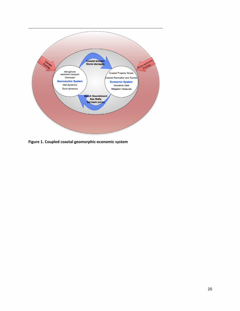
changes in both climate forcing and socio economic conditions will influence the coupled system (Figure
1). Below, we introduce the geomorphic and economic dynamics, as well as the climate and societal
forcing that drive the coupled dynamical system.
2.1 Geomorphic System Dynamics
Long-term shoreline change arises primarily from gradients in alongshore and cross-shore sediment
transport. Alongshore sediment transport involves movement of sand in the alongshore direction by
breaking waves and associated currents; annual net transport volumes can be large, up to a million m3
passing through a given cross-shore transect Alongshore gradients in this long-term net sediment flux
produce a net gain or loss of sediment locally that tends to shift the shoreline seaward (gain) or
landward (loss). Because large-scale coastline shapes (kms or larger) tend to create gradients in net
alongshore flux (different coastline orientations experience different sets of wave conditions), these
gradients then cause long-term shoreline change (Lazarus, Ashton, and Murray 2012) that reshapes
4
coastlines. On an approximately straight stretch of coastline oriented in an arbitrary direction, even
subtle curvatures can lead to progressive shoreline change, such that on most coastline stretches,
convex-seaward areas tend to erode (or erode more rapidly than the large-scale average) while
concave-seaward stretches tend to build seaward (or erode less rapidly)(Figure 2; (Lazarus, Ashton, and
Murray 2012, Ashton and Murray 2006b, Ashton and Murray 2006a). With more complex coastline
shapes, when one portion of a shoreline protects other portions from waves approaching from some
angles, shoreline changes at one location can affect shoreline changes at long distances, up to tens of
kilometers (Slott, Murray, and Ashton 2010, Ells and Murray 2012).
The alongshore-transport related component of coastline change is superimposed on long-term
coastline changes related to sea level rise (SLR), which involve movement of sediment in the cross-shore
direction (Moore et al. 2010, Wolinsky and Murray 2009). Although nearly every storm that brings large
waves to a shoreline causes temporary erosion as sand is taken offshore, that erosion is usually reversed
after the storm, as fair weather waves sweep the sand back toward the beach (List et al. 1997). During
strong storms, however, the combination of storm surge and waves can erode away existing coastal
dunes, and carry sand landward of the beach and dune. That sand can be deposited on a barrier island
(a process called ‘overwash’). Sediment deposited via overwash on a barrier island increases the
elevation of the island (at a long-term rate that tends to equal the rate of SLR in the natural state
(Moore et al. 2010)), which is beneficial because it helps to keep the island above sea level. When sand
is transported past the island and into the back-barrier bay, in a process called ‘inundation’ (Sallenger
2000), however, it does not contribute to island elevation. In either case—whether sand is retained on
top of the island (overwash) or is washed farther landward (inundation)—that sand is effectively
removed from the beach and nearshore seabed system, causing net movement of the shoreline in the
landward direction. In the long term (averaging over the characteristic return period for storms that
cause overwash or inundation), landward movement of the shoreline combined with overwash
deposition on the landward side of a barrier island causes island migration. Relative to overwash,
inundation events tend to cause a greater rate of long-term island migration, since sand is lost from the
whole barrier-island system in those events.
Sea level rise increases the frequency of overwash and inundation events (by tending to make dune and
island elevations lower relative to sea level). Therefore, increasing the rate of SLR intensifies the long-
term rate of sand removal from the nearshore system, increasing the likelihood of barrier island
migration. The rate of shoreline erosion that results depends approximately linearly on the rate of SLR,
but it also depends on a host of other factors, including the erodibility and composition of the
underlying substrate (Moore et al. 2010) as well as interactions between beach processes and
vegetation growth (‘ecomorphodynamic’ mechanisms) that influence the maximum size of coastal
dunes and the rate at which dunes recover following disturbance by storms (Durán and Moore 2013).
Human management of coastal dunes and manipulation of coastal processes and erosion rates can
further complicate the relationship between waves, currents, storms, changing sea levels, and barrier
island response.
2.2 Socioeconomic System Dynamics
The coastal environment provides an array of service flows for the coastal economy. Beach and dune
5
sediments provide erosion and storm protection for coastal development, aesthetic values for coastal
residents, space for coastal recreation and leisure activities, and natural habitat for flora and fauna
(Landry 2011). Flux of coastal sediments, thus, can affect coastal economies and prompt intervention in
coastal dynamic processes. Advocacy and support of coastal sediment management practices reflects
the diversity of local economic activities, distribution of political ideologies, and aspects of local culture
and knowledge (McNamara and Keeler 2013, Phillips and Jones 2006, Cooper and McKenna 2008).
Residential and commercial development of coastal barriers has responded to growing demand for
coastal recreation (due to increasing disposable income and influx of retirees), and development at the
shore facilitates access and enjoyment of coastal amenities. In real estate markets, sale prices reflect
the aggregation of expected flows of value over the life of the property, where future flows are
discounted. Prices reflect a property’s use value due to factors like square footage, lot size, unit type,
location, and aspects of the local neighborhood (e.g. crime rate, school district). Prices also encompass
flows of value from environmental amenities and disamenities, which can be quantified and related to
individuals’ underlying tastes (Rosen 1974). The values of recreational amenities and storm protection
provided by wide beaches, for example, are capitalized into property values. Hedonic property models
can be used to estimate economic values stemming from coastal resource quality and to predict how
coastal real estate markets respond to changes in the physical geomorphic system. These models have
been used extensively to measure the impact of beach width (Brown and Pollakowski 1977, Landry,
Keeler, and Kriesel 2003, Landry and Hindsley 2011) and storm risks (Bin et al. 2008) on coastal property
values. The distribution of property values across spatial locations ultimately depends on economic
agents who decide where to locate, sorting into different properties and markets according to their
income, their preference for amenities as well as their assessments and preferences about erosion and
storm risk.
Beaches also support economic values of coastal recreation for visitors and tourists (Bin et al. 2005, Lew
and Larson 2008, Landry and McConnell 2007). Studies of recreation demand indicate economic
benefits of coastal erosion management accruing to visitors, many of whom do not own or rent coastal
property (Parsons, Massey, and Tomasi 1999, Whitehead et al. 2008, von Haefen, Phaneuf, and Parsons
2004). There is also potential that non-visitors derive value from management of coastal erosion,
whether due to potential future use, vicarious use of others, bequest motives, or simply the existence of
coastal habitat (Silberman, Gerlowski, and Williams 1992, Shivlani, Letson, and Theis 2003). Lastly,
management of coastal sediments and the associated effects on visitation and tourism can have
significant impact on business opportunities and economic activity (creating jobs and enhancing
household income and tax revenues).
The linkage between coastal geomorphology and human use of the coastal environment is multifaceted
and complex. The economic value of coastal property, recreation, and tourism is directly dependent
upon amenity flows of beaches and dunes (storm and erosion protection and recreational, leisure, and
aesthetic services) that vary over time as coastal geomorphology changes. Both current management
actions and expectations about future actions are critical determinants of economic activity, including
real estate values, investment patterns, and visitation levels. Take property values, for instance. With
active shoreline stabilization (for example via beach nourishment), property values that reflect benefits
6
from beach nourishment may also tend to simultaneously influence subsequent nourishment decisions
and therefore beach width. Accounting for these dynamics of beach width and knowledge and
expectations of individual homebuyers can dramatically affect estimates and interpretation of coastal
amenity values (Landry and Hindsley 2011, Gopalakrishnan et al. 2011). Feedbacks in the coupled
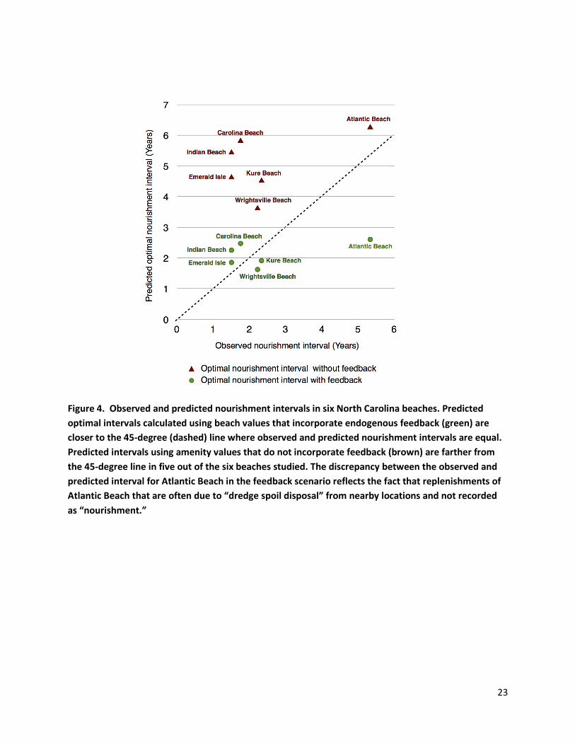
coastal-economic system are further supported by empirical analysis of beach nourishment in North
Carolina (Gopalakrishnan et al. 2011) where predicted time intervals (years) between nourishment
events are closer to observed intervals when beach amenity values used to parameterize a dynamic
model of optimal beach management incorporate feedbacks (Figure 4).
In addition to the relatively slow changes associated with chronic coastline erosion, large storm events
can have a punctuated, negative effect on property values, though values often recover over time (Bin
and Landry 2013). Storm surge and the large waves that coincide with storm events can cause
widespread destruction of coastal property and infrastructure. The degree to which these damages
impact coastal economies is strongly tied to both plan view physical coastline characteristics, such as
coastline position and associated fronting beach width, and vertical coastline features, such as height
above mean sea level and dune elevation.
2.3 Climate Forcing
The Intergovernmental Panel on Climate Change (IPCC 2013, 5th Assessment Report) estimates that
global sea level will rise between 28 and 61 cm by the year 2100. These predictions explicitly exclude the
effects of ice sheet flow and are generally considered lower bounds on the amount of SLR that will
occur. Several factors, including local changes in land surface elevation (e.g., due to subsidence, glacio-
isostatic adjustment) and changing ocean currents (Ezer et al. 2013), will cause relative changes in sea
level to vary from place to place. Globally, warming will also likely increase the frequency of the
strongest hurricanes (Knutson et al. 2010, Bender et al. 2010), with warming of mid-latitude coastal
oceans increasing landfalling storm intensity for the US Atlantic coastline, in particular (as has possibly
already been observed (Komar and Allan 2008)).
2.4 Socioeconomic Forcing
Not all relevant features of the socioeconomic environment are characterized by two-way couplings to
the geomorphic system; some socioeconomic conditions are exogenous to but nonetheless important
drivers of coastline change. Growth in demand for coastal real estate is the obvious example. It is
estimated that over half the world population is concentrated in the coastal zone covering just 10% of
the earth’s land surface (NOAA 2009) and this trend is persisting despite growing concerns about coastal
hazards. As the size of the population living at the coast increases, the value of the built environment
rises accordingly. And as the value of property at risk increases, the set of economically justifiable
engineering interventions along the coast expands. Similarly, high real estate values and large coastal
populations can put pressure on policy makers to address coastal hazards. The State of North Carolina,
USA, for example, had banned hard structures on the coast from 1985 until 2011, when it passed
legislation allowing for a limited number of groynes to be built adjacent to tidal inlets. It remains to be
seen whether economic pressures for property protection will expand this reversal as more and more
coastal property and infrastructure face greater risks.
7
Public policies exogenous to specific coastal locations can also have strong effects on economic choices
in coastal property markets and, through these effects, serve as drivers of the choices communities
make about altering the physical coastline. Examples in the US include flood insurance, disaster relief,
and investments in and maintenance of transportation and utility infrastructure. Climate hazard
insurance covering coastal flooding is currently managed primarily by the federal government through
the National Flood Insurance Program (Dixon et al. 2006, Michel-Kerjan 2010). Higher insurance rates
and greater limitations in coverage can increase incentives to invest in shoreline stabilization to reduce
financial risk (Botzen, Aerts, and van den Bergh 2009). In other circumstances, however, less favorable
insurance coverage can reduce the value of coastal investment, lowering incentives for shoreline
engineering. Disaster relief has similarly ambiguous impacts on choices about defensive engineering.
High expectations about disaster relief payouts can directly reduce the value of shoreline stabilization by
decreasing financial risk from climate-related events. Larger disaster relief expenditures, however, tend
to encourage development patterns that increase the overall value and vulnerability of the built
environment and can therefore incentivize shoreline engineering.
Policies regarding investment in transportation and utilities infrastructure and support for shoreline
engineering are central to the coupled system’s evolution. Such investments are affected by local, state,
and national policies, and influence diverse aspects of the costs and benefits of owning coastal property.
Investments that tend to reduce the risk and hassle of interruptions in basic services will increase the
value of coastal property and therefore tend to increase incentives to protect property through
shoreline engineering. Shoreline engineering has historically been financed by both local and national
entities, with the balance shifting toward local financing in recent years. Federal policy continues to
affect the local cost of engineering projects, both through decisions about explicit and implicit
subsidization and through regulatory policies that affect the difficulty and expense of implementing and
monitoring engineering projects.
In the remainder of this chapter, we explore several dimensions in which coastal geomorphology and
coastal economies are coupled. These couplings raise difficult questions about where, when, and in
what manner humans should intervene in coastline change. We highlight the challenges involved in
making purposeful decisions that avoid inadvertent and uncoordinated geoengineering of our
coastlines.
3. Alongshore Connections: Communities Affect Each Other
Human manipulations can affect coastlines at least as much as natural processes do. Coastal engineers
have long understood that human interventions to stabilize beaches can have spatial spillovers at the
local level. A groyne in one location, for instance, alters alongshore sediment transport and has direct
implications for adjacent locations. Similarly, a ‘beach nourishment’ (beach extension/construction)
project that creates a subtle seaward bump in the shoreline can increase the rates of net sediment
delivery to adjacent beaches. When towns implement localized stabilization policies, not accounting for
the physical and economic implications of these dynamic spatial interactions, it results in suboptimal
outcomes relative to coordinated management of the coastline (Gopalakrishnan, et al., 2013 In Review).
8
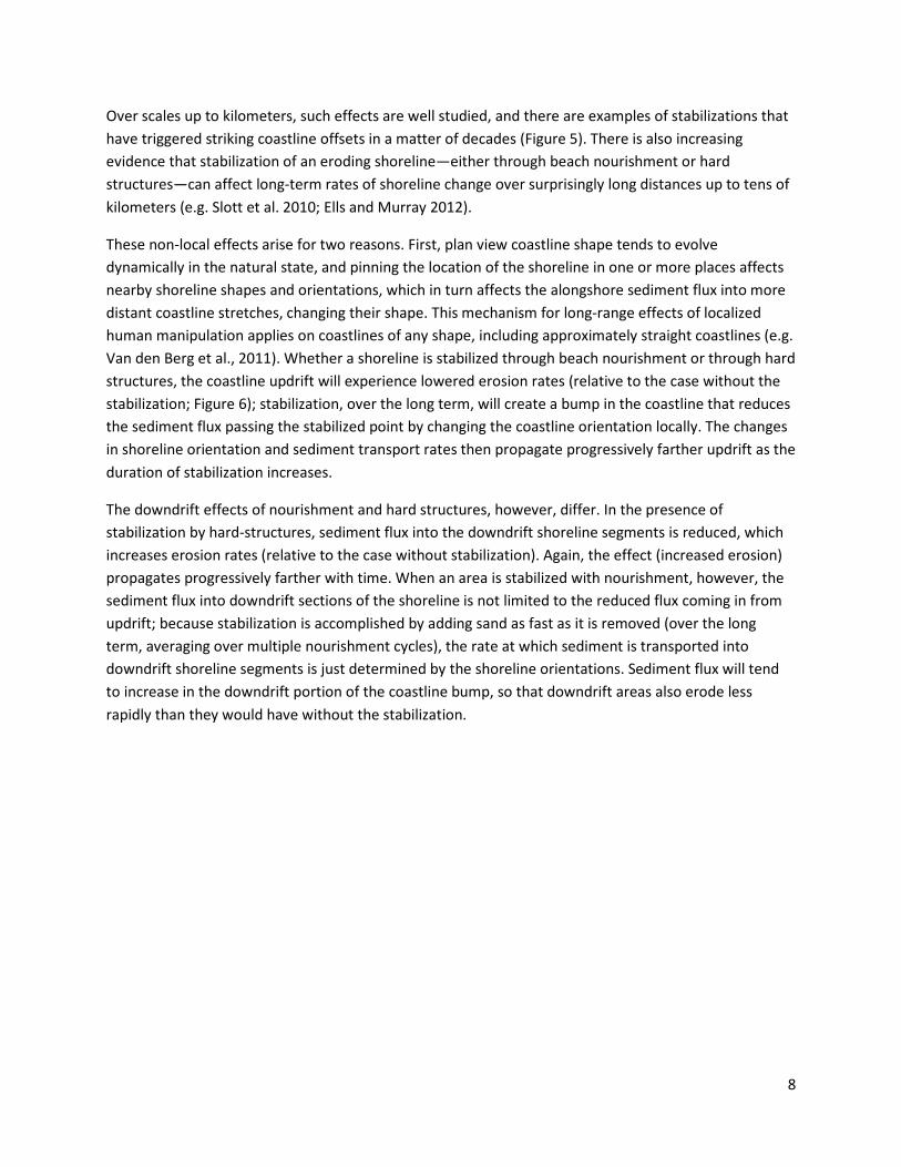
Over scales up to kilometers, such effects are well studied, and there are examples of stabilizations that
have triggered striking coastline offsets in a matter of decades (Figure 5). There is also increasing
evidence that stabilization of an eroding shoreline—either through beach nourishment or hard
structures—can affect long-term rates of shoreline change over surprisingly long distances up to tens of
kilometers (e.g. Slott et al. 2010; Ells and Murray 2012).
These non-local effects arise for two reasons. First, plan view coastline shape tends to evolve
dynamically in the natural state, and pinning the location of the shoreline in one or more places affects
nearby shoreline shapes and orientations, which in turn affects the alongshore sediment flux into more
distant coastline stretches, changing their shape. This mechanism for long-range effects of localized
human manipulation applies on coastlines of any shape, including approximately straight coastlines (e.g.
Van den Berg et al., 2011). Whether a shoreline is stabilized through beach nourishment or through hard
structures, the coastline updrift will experience lowered erosion rates (relative to the case without the
stabilization; Figure 6); stabilization, over the long term, will create a bump in the coastline that reduces
the sediment flux passing the stabilized point by changing the coastline orientation locally. The changes
in shoreline orientation and sediment transport rates then propagate progressively farther updrift as the
duration of stabilization increases.
The downdrift effects of nourishment and hard structures, however, differ. In the presence of
stabilization by hard-structures, sediment flux into the downdrift shoreline segments is reduced, which
increases erosion rates (relative to the case without stabilization). Again, the effect (increased erosion)
propagates progressively farther with time. When an area is stabilized with nourishment, however, the
sediment flux into downdrift sections of the shoreline is not limited to the reduced flux coming in from
updrift; because stabilization is accomplished by adding sand as fast as it is removed (over the long
term, averaging over multiple nourishment cycles), the rate at which sediment is transported into
downdrift shoreline segments is just determined by the shoreline orientations. Sediment flux will tend
to increase in the downdrift portion of the coastline bump, so that downdrift areas also erode less
rapidly than they would have without the stabilization.
9
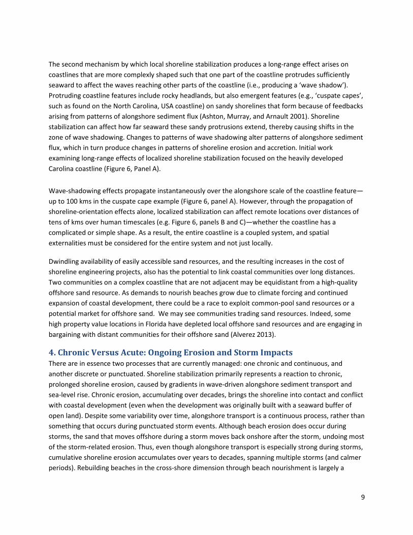
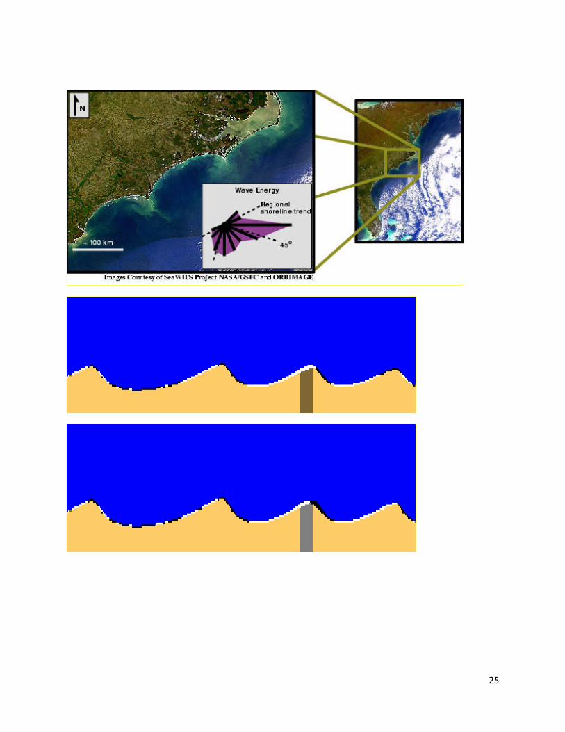
The second mechanism by which local shoreline stabilization produces a long-range effect arises on
coastlines that are more complexly shaped such that one part of the coastline protrudes sufficiently
seaward to affect the waves reaching other parts of the coastline (i.e., producing a ‘wave shadow’).
Protruding coastline features include rocky headlands, but also emergent features (e.g., ‘cuspate capes’,
such as found on the North Carolina, USA coastline) on sandy shorelines that form because of feedbacks
arising from patterns of alongshore sediment flux (Ashton, Murray, and Arnault 2001). Shoreline
stabilization can affect how far seaward these sandy protrusions extend, thereby causing shifts in the
zone of wave shadowing. Changes to patterns of wave shadowing alter patterns of alongshore sediment
flux, which in turn produce changes in patterns of shoreline erosion and accretion. Initial work
examining long-range effects of localized shoreline stabilization focused on the heavily developed
Carolina coastline (Figure 6, Panel A).
Wave-shadowing effects propagate instantaneously over the alongshore scale of the coastline feature—
up to 100 kms in the cuspate cape example (Figure 6, panel A). However, through the propagation of
shoreline-orientation effects alone, localized stabilization can affect remote locations over distances of
tens of kms over human timescales (e.g. Figure 6, panels B and C)—whether the coastline has a
complicated or simple shape. As a result, the entire coastline is a coupled system, and spatial
externalities must be considered for the entire system and not just locally.
Dwindling availability of easily accessible sand resources, and the resulting increases in the cost of
shoreline engineering projects, also has the potential to link coastal communities over long distances.
Two communities on a complex coastline that are not adjacent may be equidistant from a high-quality
offshore sand resource. As demands to nourish beaches grow due to climate forcing and continued
expansion of coastal development, there could be a race to exploit common-pool sand resources or a
potential market for offshore sand. We may see communities trading sand resources. Indeed, some
high property value locations in Florida have depleted local offshore sand resources and are engaging in
bargaining with distant communities for their offshore sand (Alverez 2013).
4. Chronic Versus Acute: Ongoing Erosion and Storm Impacts
There are in essence two processes that are currently managed: one chronic and continuous, and
another discrete or punctuated. Shoreline stabilization primarily represents a reaction to chronic,
prolonged shoreline erosion, caused by gradients in wave-driven alongshore sediment transport and
sea-level rise. Chronic erosion, accumulating over decades, brings the shoreline into contact and conflict
with coastal development (even when the development was originally built with a seaward buffer of
open land). Despite some variability over time, alongshore transport is a continuous process, rather than
something that occurs during punctuated storm events. Although beach erosion does occur during
storms, the sand that moves offshore during a storm moves back onshore after the storm, undoing most
of the storm-related erosion. Thus, even though alongshore transport is especially strong during storms,
cumulative shoreline erosion accumulates over years to decades, spanning multiple storms (and calmer
periods). Rebuilding beaches in the cross-shore dimension through beach nourishment is largely a
10
response to this ongoing, approximately continuous process as well as the continuous process of sea-
level rise.
In contrast to continuous processes, storms are discrete, stochastic events that can bring large waves,
storm surge, and wind—causing sediment to move in the cross-shore direction, and possibly creating
fundamental change in configurations of coastal development. Storms highlight the importance of
cross-shore processes and the vertical dimension of beachfront development. Increasingly, augmenting
the vertical dimension of the beach with nourishment is seen as a strategy for storm damage mitigation.
However, efforts to protect coastal development in the short-run (e.g. building seawalls or artificially tall
and continuous sand dunes) alter or prevent overwash during all but the most extreme storms.
Construction of dense development itself can also alter or prevent overwash. When extreme storms
occur, coastal development, infrastructure, and coastal protection affect the pattern and volume of
sediment flux. When overwash occurs on a developed coastline, humans typically remove it quickly (to
exhume roads and other infrastructure), bulldozing sand back to the beach to rebuild a protective dune
line or trucking it elsewhere. All of these human influences on sand deposition by overwash prevent
natural processes from increasing island elevation (Magliocca, McNamara, and Murray 2011) –
increasing long-term vulnerability from erosion and flooding.
In addition, because overwash removes sediment from the beach and nearshore system, tending to
move the shoreline landward, combating storm processes that occur in the vertical dimension affects
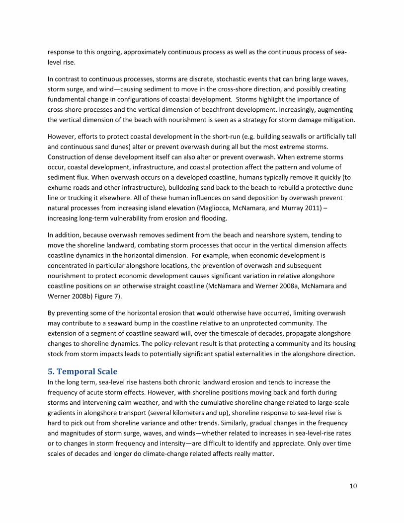
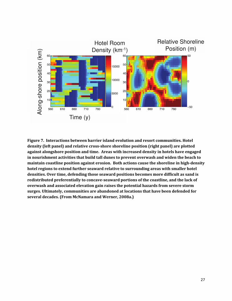
coastline dynamics in the horizontal dimension. For example, when economic development is
concentrated in particular alongshore locations, the prevention of overwash and subsequent
nourishment to protect economic development causes significant variation in relative alongshore
coastline positions on an otherwise straight coastline (McNamara and Werner 2008a, McNamara and
Werner 2008b) Figure 7).
By preventing some of the horizontal erosion that would otherwise have occurred, limiting overwash
may contribute to a seaward bump in the coastline relative to an unprotected community. The
extension of a segment of coastline seaward will, over the timescale of decades, propagate alongshore
changes to shoreline dynamics. The policy-relevant result is that protecting a community and its housing
stock from storm impacts leads to potentially significant spatial externalities in the alongshore direction.
5. Temporal Scale
In the long term, sea-level rise hastens both chronic landward erosion and tends to increase the
frequency of acute storm effects. However, with shoreline positions moving back and forth during
storms and intervening calm weather, and with the cumulative shoreline change related to large-scale
gradients in alongshore transport (several kilometers and up), shoreline response to sea-level rise is
hard to pick out from shoreline variance and other trends. Similarly, gradual changes in the frequency
and magnitudes of storm surge, waves, and winds—whether related to increases in sea-level-rise rates
or to changes in storm frequency and intensity—are difficult to identify and appreciate. Only over time
scales of decades and longer do climate-change related affects really matter.
11
Despite these long time scales, the likely effects of climate change tend to push time scales of coastal
geomorphology closer to meaningful economic time scales. Already, sea levels are high enough, storms
are frequent and intense enough, and alongshore sediment transport is sufficiently powerful to trigger
human responses to defend the shoreline. Sea-level rise, changing wave climates, and intensification of
tropical storms all have the potential to speed up physical coastline changes (Slott et al. 2006, Moore et
al. 2013). This acceleration, in turn, could influence the kind and scale of adaptive responses by humans
due to higher erosion rates in developed areas. Moreover, these elements of climate change have the
potential to interact with one another. With sea-level rise, for example, the same net impact of storm
surge could come from a less intense storm. A more intense storm on top of sea-level rise has the
potential to generate even more catastrophic storm surge.
As climate forcing intensifies and potentially accelerates coupled morpho-economic dynamics, there is
potential for emergence of large-scale human/coastline phenomena on meaningful economic time
scales. This is the essence of inadvertent geoengineering: human responses to climate-driven risks can
produce coastlines with qualitatively different and unintended characteristics. Indeed, climate forcing
that raises the background erosion rate can destabilize an entire coastline as individual communities
pursue independent shoreline stabilization strategies (Lazarus et al. 2011).
Another important time scale is the how human perceptions change and, in turn, motivate different
behaviors along human-occupied coastlines Economically driven manipulations to the coastline in part
reflect human perceptions of long time-scale physical processes. There can also be significant
differences in these perceptions over large spatial scales. For example, the state of North Carolina
recently attempted to regulate projections of future rates of sea level rise so that they remained within
historical rates while other regions such as New York City are discussing fortification against some of the
worst-case projections for sea level rise. As we have shown, coastline alterations can have unintended
long-range effects, which means that variations in the perception of the physical processes and
subsequent variations in coastline modification could lead to variations in the unintended consequences
of coastline geoengineering.
6. Jurisdictional Divisions
The question of which jurisdictional level—e.g. federal, state, or local—should regulate the environment
has long interested economists and political scientists and has spawned a substantial literature in
environmental federalism. The general thinking in economics is that highest jurisdictional level (federal)
is the right level for problems that involve pure public goods that society at large enjoys, whereas the
lowest level (local) makes sense for problems where local jurisdictions capture all of the benefits and
costs of regulating environmental quality
Most real-world situations are somewhere in between, where benefits of environmental quality flow
(Oates 1999, 2001) disproportionately to the local jurisdiction, but there are significant spillovers into
other jurisdictions that may warrant higher level regulatory coordination.
12
The problems of stabilizing coastlines and adaptating to climate change reflect classic tensions in the
environmental federalism literature. For example, the spatial externality of the groyne with immediate
impacts through alongshore sediment transport on a neighboring community is a typical example of a
spillover that requires rulemaking above the local jurisdiction. Construction of a sea wall to protect
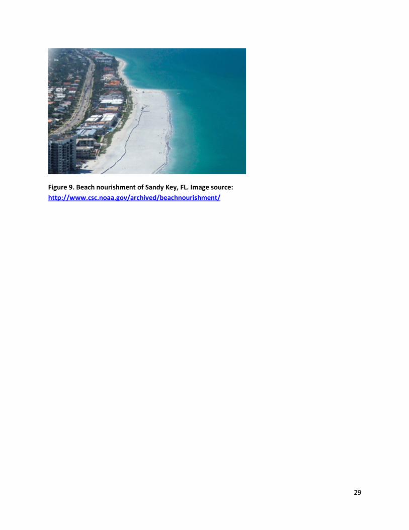
private beachfront property can have almost immediate and deleterious effects on public beaches. In
fact, stabilization decisions frequently take place with funding and decision-making at both the
municipality and county level. Similarly, maintaining a wide beach generates amenities that directly
benefit local homeowners – and are capitalized into the value of the property they own—but also spill
over to benefit beachgoers who travel from outside the local jurisdiction. A wide, nourished beach can
accommodate many more beachgoers than a narrow, unnourished beach wedged between existing
development and the sea (Figure 9).
While these features fit neatly into the environmental federalism taxonomy, there are unique features
of coastline stabilization that highlight more vexing cross-jurisdictional externalities. First, the allocation
of funds at the federal level has the potential to generate unintended spatial-dynamic externalities. In
the U.S., a significant portion of funds for beach nourishment come from federal spending. Projects are
funded and approved on a case-by-case basis, and the fact that federal commitments through the Army
Corps of Engineers have historically been made for very long time periods (typically 50 years) has
created a legacy of previous decisions that impedes federal consideration of spatial-dynamic feedbacks
or prioritization of future projects. A project that may pass a benefit-cost test in a vacuum (or even have
the highest benefit-to-cost ratio amongst a set of proposed projects) could produce a net loss as a result
of feedbacks produced through alongshore sediment transport and the propagation of large-scale
spatial features.
Second, communities are linked to each other through exploitation of common sand resources.
Particularly along complex coastlines, such as the cuspate coast of the Carolinas, communities that may
be far away from each other along the shoreline may have similar proximity to economically recoverable
and high-quality offshore sand resources. Because no individual community owns these resources, there
may be incentives to overexploit them or race to exploit them as the race to fish unfolds in open access
settings. A shift from predominantly federal to more local funding for nourishment will tend to
exacerbate this race-to-nourish effect, as availability of cheap sand directly affects the local tax burden.
An additional complication is the presence of vacation home owners whose property is taxed locally but
who live elsewhere and are unable to vote in local elections that may affect nourishment decisions.
These behaviors create another form of spatially uncoordinated behavior that could then propagate
spatial features over large scales.
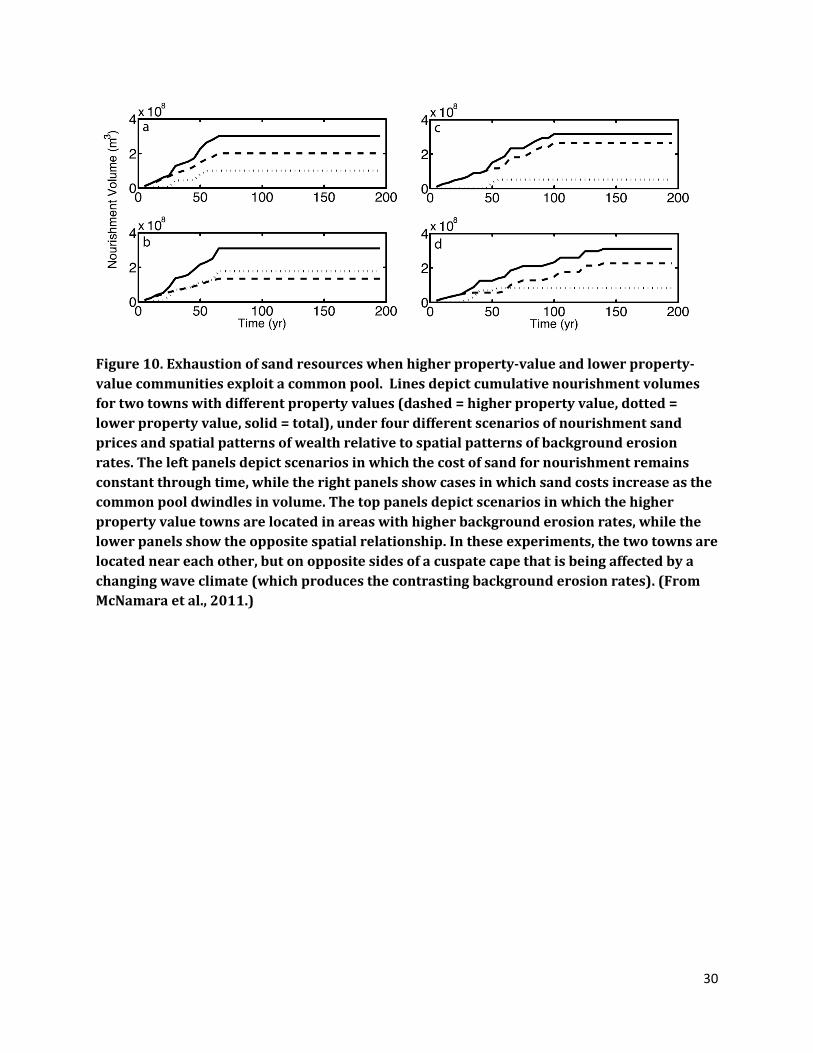
In numerical model simulations where two communities compete for common sand resources and the
cost of acquiring sand for nourishment rises with dwindling supply, the lifetime of available sand
depends strongly on the interaction between patterns of property value and erosion rates (Figure 10).
Specifically, when high property value towns are located in regions of high erosion, sand resources
shared by high- and low-property-value towns can dwindle rapidly. This raises the possibility that
combinations of property value and background erosion rates at one location could affect the ability of
towns in other locations to defend against shoreline erosion.
13
Complicating the above jurisdictional confusion that makes efficient management of spatial feedbacks
problematic are a set of federal policies that have direct implications for shoreline stabilization. Post-
storm disaster relief and federal flood insurance, as well as environmental review under the National
Environmental Policy Act for consistency with federal environmental statutes, all have significant effects
on the design options and long-term flow of costs and benefits of beach engineering projects. These
policies are designed to meet a range of goals in protecting public goods, mitigating moral hazard, and
correcting market failures. They have the effect of changing the incentives and choices of individual
property owners and local / regional governments in complex and unpredictable ways.
7. Discussion
The tight coupling of human and natural systems described in this chapter points to the need for
coordinated decision-making to set rules and incentives for coastal management. Unfortunately, the
processes and feedbacks that characterize the system do not fit into existing political, economic, or
regulatory structures. Our understanding of the geomorphological effects of uncoordinated human
actions on the coast is improving rapidly, but there is little indication that we are similarly improving our
ability to use this knowledge to produce better outcomes. A shift from accidental to intentional
geoengineering of the coast could enhance the well-being of coastal communities.
Although use of coupled systems science presents opportunities relative to the status quo, our
understanding of these systems is nascent, and our ability to practice intentional geoengineering of
whole coastlines inevitably will be limited. Harnessing our coupled systems science to make better
decisions should not inspire overconfidence in predictions about coastline changes and associated
effects on coastal communities. Tremendous uncertainty will remain even if coastal planners
incorporate the best science available. When scientists have such uncertainty about managed dynamical
systems, calls for adaptive management are ubiquitous. As humans intervene in the coastline, one
naturally would wish to learn from that experience and apply it to future decisions. And one even may
wish to design coastline interventions with the intent of gaining knowledge about how the coupled
system works. The conceptual appeal of adaptive management is undeniable. However, its practice in a
coupled coastline system with multiple interacting spatial and temporal scales is far from clear. Practical
implementation requires determining what constitutes real information about the functioning of the
coupled coastline system. If we shift toward coordinated management of coasts informed by coupled
systems thinking, how do we evaluate the outcomes that we observe? Which changes can meaningfully
be attributed to human decisions (whether directly or through feedbacks in the spatial-dynamics); which
changes are attributable to external forcing (physical or socieoeconomic); which changes are truly
random shocks to the system; and what time scale do we use to assess the impacts of our planning
decisions? The scientific challenges are daunting, but the alternative to this path is to inherit a
geoengineered coastline that our society did not choose.

14
15
References:
AIR, Worldwide Corporation. 2008. The Coastline at Risk: 2008 Update to the Estimated Insured Value of
U.S. Coastal Properties.
Alvarez, Lizette. 2013. Where Sand Is Gold, the Reserves Are Running Dry. The New York Times. August
24, 2013. http://www.nytimes.com/2013/08/25/us/where-sand-is-gold-the-coffers-are-running-
dry-in-florida.html?_r=0
Ashton, A, and A.B Murray. 2006a. "High-angle wave instability and emergent shoreline shapes: 1.
Modeling of capes, flying spits and sandwaves." Journal of Geophysical Research no. 111
(F04011). doi: 10.1029/2005JF000422.
Ashton, A., A.B. Murray, and Olivier Arnault. 2001. "Formation of coastline features by large-scale
instabilities induced by high-angle waves." Nature no. 414:296-300.
Ashton, A.D., and A. B. Murray. 2006b. "High-angle wave instability and emergent shoreline shapes: 2.
Wave climate analysis and comparisons to nature." Journal of Geophysical Research no. 111
(F04012).
Bell, F.W. 1986. "Economic Policy Issues Associated with Beach Renourishment." Policy Studies Review
no. 6:374–81.
Bender, Morris A., Thomas R. Knutson, Robert E. Tuleya, Joseph J. Sirutis, Gabriel A. Vecchi, Stephen T.
Garner, and Isaac M. Held. 2010. "Modeled Impact of Anthropogenic Warming on the Frequency
of Intense Atlantic Hurricanes." Science no. 327 (5964):454-458. doi: 10.1126/science.1180568.
Bin, Okmyung, Thomas W. Crawford, Jamie B. Kruse, and Craig E. Landry. 2008. "Viewscapes and Flood
Hazard: Coastal Housing Market Response to Amenities and Risk." Land Economics no. 84
(3):434-448. doi: 10.3368/le.84.3.434.
Bin, Okmyung, and Craig E. Landry. 2013. "Changes in Implicit Flood Risk Premiums: Empirical Evidence
from the Housing Market." forthcoming Journal of Environmental Economics & Management.
Bin, Okmyung, Craig E. Landry, Christopher L. Ellis, and Hans Vogelsong. 2005. "Some Consumer Surplus
Estimates for North Carolina Beaches." Marine Resource Economics no. 20 (2):145-161. doi:
http://www.uri.edu/cels/enre/mre/mre.htm.
Botzen, W. J. W., J. C. J. H. Aerts, and J. C. J. M. van den Bergh. 2009. "Willingness of homeowners to
mitigate climate risk through insurance." Ecological Economics no. 68 (8-9):2265-2277. doi:
10.1016/j.ecolecon.2009.02.019.
Brown, G.M., and H.O. Pollakowski. 1977. "Economic Valuation of Shoreline." The Review of Economics
and Statistics no. 59:272 - 278.
Cooper, JAG, and John McKenna. 2008. "Social justice in coastal erosion management: The temporal and
spatial dimensions." Geoforum no. 39 (1):294-306.
16
Dixon, L., N. Clancy, S.A. Seabury, and A. Overton. 2006. The National Flood Insurance Program's Market
Penetration Rate: Estimates and Policy Implications. Santa Monica, CA: RAND Corporation.
Durán, Orencio, and Laura J Moore. 2013. "Vegetation controls on the maximum size of coastal dunes."
Proceedings of the National Academy of Sciences no. 110 (43):17217-17222.
Ells, Kenneth, and A. Brad Murray. 2012. "Long-term, non-local coastline responses to local shoreline
stabilization." Geophys. Res. Lett. no. 39 (19):L19401.
Ezer, Tal, Larry P Atkinson, William B Corlett, and Jose L Blanco. 2013. "Gulf Stream's induced sea level
rise and variability along the US mid-Atlantic coast." Journal of Geophysical Research: Oceans.
Gopalakrishnan, Sathya, Martin D. Smith, Jordan M. Slott, and A. Brad Murray. 2011. "The value of
disappearing beaches: A hedonic pricing model with endogenous beach width." Journal of
Environmental Economics and Management no. 61 (3):297-310. doi:
10.1016/j.jeem.2010.09.003.
Knutson, Thomas R., John L. McBride, Johnny Chan, Kerry Emanuel, Greg Holland, Chris Landsea, Isaac
Held, James P. Kossin, A. K. Srivastava, and Masato Sugi. 2010. "Tropical cyclones and climate
change." Nature Geoscience no. 3 (3):157-163.
Komar, Paul D., and Jonathan C. Allan. 2008. "Increasing Hurricane-Generated Wave Heights along the
U.S. East Coast and Their Climate Controls." Journal of Coastal Research no. 24 (2):479-488. doi:
10.2112/07-0894.1.
Landry, Craig E. 2011. "Coastal erosion as a natural resource management problem: An economic
perspective." Coastal Management no. 39 (3):259-281.
Landry, Craig E, and Kenneth E McConnell. 2007. "Hedonic onsight cost model of recreation demand."
Land Economics no. 83 (2):253-267.
Landry, Craig E., and Paul Hindsley. 2011. "Valuing Beach Quality with Hedonic Property Models." Land
Economics no. 87 (1):92-108.
Landry, Craig E., Andrew Keeler, and Warren Kriesel. 2003. "An Economic Evaluation of Beach Erosion
Management Alternatives." Marine Resource Economics no. 18 (2):105 - 127.
Lazarus, E., A. Ashton, and A.B. Murray. 2012. "Large-scale patterns in hurricane-driven shoreline
change." In Extreme Events and Natural Hazards: The Complexity Perspective, edited by A.S.
Sharma, V.P. Dimri and A. Bunde. American Geophysical Union.
Lazarus, E. D., D. E. McNamara, M. D. Smith, S. Gopalakrishnan, and A. B. Murray. 2011. "Emergent
behavior in a coupled economic and coastline model for beach nourishment." Nonlin. Processes
Geophys. no. 18 (6):989-999. doi: 10.5194/npg-18-989-2011.
Lazarus, Eli D, and A Brad Murray. 2011. "An integrated hypothesis for regional patterns of shoreline
change along the northern North Carolina Outer Banks, USA." Marine Geology no. 281 (1):85-90.
17
Lew, Daniel K, and Douglas M Larson. 2008. "Valuing a beach day with a repeated nested logit model of
participation, site choice, and stochastic time value." Marine Resource Economics no. 23 (3):233.
List, Jeffrey H., Asbury H. Sallenger Jr, Mark E. Hansen, and Bruce E. Jaffe. 1997. "Accelerated relative
sea-level rise and rapid coastal erosion:: testing a causal relationship for the Louisiana barrier
islands." Marine Geology no. 140 (3-4):347-365.
Magliocca, N. R., D. E. McNamara, and A. B. Murray. 2011. "Long-Term, Large-Scale Morphodynamic
Effects of Artificial Dune Construction along a Barrier Island Coastline." Journal of Coastal
Research no. 27 (5):918-930. doi: 10.2112/jcoastres-d-10-00088.1.
McNamara, D. E., and B. T. Werner. 2008a. "Coupled barrier island–resort model: 1. Emergent
instabilities induced by strong human-landscape interactions." Journal of Geophysical Research
no. 113 (F01016). doi: 10.1029/2007JF000840.
McNamara, D., and A. Keeler. 2013. "A Coupled Physical and Economic Model of Coastal Real Estate
Response to Climate Risk." Nature Climate Change no. in press.
McNamara, D., A.B. Murray, and M.D. Smith. 2011. "Coastal sustainability depends on how economic
and coastline responses to climate change affect each other." Geophysical Research Letters no.
38. doi: 10.1029/2011GL047207.
McNamara, DE, and BT Werner. 2008b. "Coupled barrier island–resort model: 2. Tests and predictions
along Ocean City and Assateague Island National Seashore, Maryland." Journal of Geophysical
Research: Earth Surface (2003–2012) no. 113 (F1).
Michel-Kerjan, E.O. 2010. "Catastrophic Economics: The National Flood Insurance Program." Journal of
Economic Perspectives no. 24 (4):165-186.
Moore, Laura J, Dylan E McNamara, A Brad Murray, and Owen Brenner. 2013. "Observed changes in
hurricane-driven waves explain the dynamics of modern cuspate shorelines." Geophysical
Research Letters no. 40 (22):5867-5871.
Moore, Laura J., Jeffrey H. List, S. Jeffress Williams, and David Stolper. 2010. "Complexities in barrier
island response to sea level rise: Insights from numerical model experiments, North Carolina
Outer Banks." Journal of Geophysical Research no. 115 (27). doi: 10.1029/2009JF001299.
Nicholls, Robert J, Poh Poh Wong, Virginia Burkett, Jorge Codignotto, John Hay, Roger McLean,
Sachooda Ragoonaden, Colin D Woodroffe, PAO Abuodha, and J Arblaster. 2007. "Coastal
systems and low-lying areas." In Climate Change 2007: Impacts, Adaptation and Vulnerability.
Contribution of Working Group II to the Fourth Assessment Report of the Intergovernmental
Panel on Climate Change, edited by O.F. Canziani M.L. Parry, J.P. Palutikof, P.J. van der Linden
and C.E. Hanson. Cambridge University Press, Cambridge, UK, 315-356.
NOAA. Beach Nourishment: A Guide for Local Government Officials – Historical Expenditures for Beach
Nourishment Projects: Geographical Distribution of Projects and Sources of Funding. Coastal
Services Center website:
http://www.csc.noaa.gov/beachnourishment/html/human/socio/change.htm, accesssed 2013
2009.
18
Oates, Wallace E. 1999. "An essay on fiscal federalism." Journal of economic literature no. 37 (3):1120-
1149.
Oates, Wallace E. 2001. A reconsideration of environmental federalism: Resources for the Future
Washington, DC.
Parsons, George R., D. Matthew Massey, and Ted Tomasi. 1999. "Familiar and Favorite Sites in a Random
Utility Model of Beach Recreation." Marine Resource Economics no. 14 (4):299-315. doi:
http://www.uri.edu/cels/enre/mre/mre.htm.
Parsons, George R., and Michael Powell. 2001. "Measuring the Cost of Beach Retreat." Coastal
Management no. 29 (2):91 - 103.
Phillips, MR, and AL Jones. 2006. "Erosion and tourism infrastructure in the coastal zone: Problems,
consequences and management." Tourism Management no. 27 (3):517-524.
Pilkey, Orrin H, and Katharine L Dixon. 1996. The Corps and the shore: Island Press.
Pilkey, Orrin H, and Rob Young. 2008. The rising sea: Island Press.
Riggs, Stanley R, and DV Ames. 2003. "Drowning the North Carolina coast: sea-level rise and estuarine
dynamics."
Rosen, Sherwin. 1974. "Hedonic Prices and Implicit Markets - Product Differentiation in Pure
Competition." Journal of Political Economy no. 82 (1):34-55.
Sallenger, A.H. 2000. "Storm impact scale for barrier islands." Journal of Coastal Research no. 16 (3):890-
895.
Shivlani, Manoj P., David Letson, and Melissa Theis. 2003. "Visitor Preferences for Public Beach
Amenities and Beach Restoration in South Florida." Coastal Management no. 31 (4):367-385.
Silberman, Jonathan, Daniel A Gerlowski, and Nancy A Williams. 1992. "Estimating existence value for
users and nonusers of New Jersey beaches." Land Economics:225-236.
Slott, J. M., A. B. Murray, and A. D. Ashton. 2010. "Large-scale responses of complex-shaped coastlines
to local shoreline stabilization and climate change." Journal of Geophysical Research-Earth
Surface no. 115. doi: F03033 10.1029/2009jf001486.
Slott, Jordan. M, A. B. Murray, A. D. Ashton, and T. J. Crowley. 2006. "Coastline responses to changing
storm patterns." Geophysical Research Letters no. 33 (L18404). doi: 10.1029/2006GL027445.
Small, Christopher, and Robert J. Nicholls. 2003. "A Global Analysis of Human Settlement in Coastal
Zones." Journal of Coastal Research no. 19 (3):584-599. doi: 10.2307/4299200.
Smith, Martin D., Jordan M Slott, Dylan McNamara, and A. Brad Murray. 2009. "Beach Nourishment as a
Dynamic Capital Accumulation Problem." Journal of Environmental Economics and Management
no. 58 (1):58-71.
19
Van den Berg, Niels, Albert Falqués, and Francesca Ribas. "Long-term evolution of nourished beaches
under high angle wave conditions." Journal of Marine Systems 88, no. 1 (2011): 102-112.
von Haefen, Roger, Daniel Phaneuf, and George R. Parsons. "Estimation and welfare analysis with large
demand systems." Journal of Business and Economics Statistics 22, no. 2 (2004).
Whitehead, John C., Christopher F. Dumas, Jim Herstine, Jeffery Hill, and Bob Buerger. 2008. "Valuing
Beach Access and Width with Revealed and Stated Preference Data." Marine Resource
Economics no. 23 (2):119-135. doi: http://www.uri.edu/cels/enre/mre/mre.htm.
Wolinsky, M.A., and A.B Murray. 2009. "A unifying framework for shoreline migration: 2. Application to
wave-dominated coasts." Journal of Geophysical Research- Earth Surface no. 114 (F01009).
20
Figure 1. Coupled coastal geomorphic-economic system
21
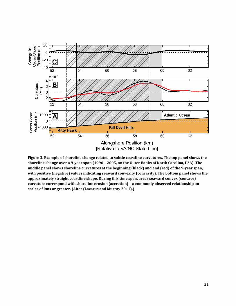
Figure 2. Example of shoreline change related to subtle coastline curvatures. The top panel shows the
shoreline change over a 9-year span (1996 – 2005, on the Outer Banks of North Carolina, USA). The
middle panel shows shoreline curvatures at the beginning (black) and end (red) of the 9-year span,
with positive (negative) values indicating seaward convexity (concavity). The bottom panel shows the
approximately straight coastline shape. During this time span, areas seaward convex (concave)
curvature correspond with shoreline erosion (accretion)—a commonly observed relationship on
scales of kms or greater. (After (Lazarus and Murray 2011).)
22
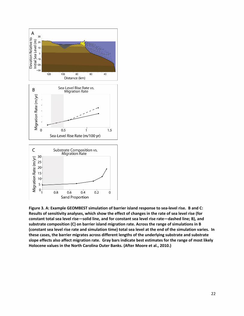
Figure 3. A: Example GEOMBEST simulation of barrier island response to sea-level rise. B and C:
Results of sensitivity analyses, which show the effect of changes in the rate of sea level rise (for
constant total sea level rise—solid line, and for constant sea level rise rate—dashed line; B), and
substrate composition (C) on barrier island migration rate. Across the range of simulations in B
(constant sea level rise rate and simulation time) total sea level at the end of the simulation varies. In
these cases, the barrier migrates across different lengths of the underlying substrate and substrate
slope effects also affect migration rate. Gray bars indicate best estimates for the range of most likely
Holocene values in the North Carolina Outer Banks. (After Moore et al., 2010.)
23
Figure 4. Observed and predicted nourishment intervals in six North Carolina beaches. Predicted
optimal intervals calculated using beach values that incorporate endogenous feedback (green) are
closer to the 45-degree (dashed) line where observed and predicted nourishment intervals are equal.
Predicted intervals using amenity values that do not incorporate feedback (brown) are farther from
the 45-degree line in five out of the six beaches studied. The discrepancy between the observed and
predicted interval for Atlantic Beach in the feedback scenario reflects the fact that replenishments of
Atlantic Beach that are often due to “dredge spoil disposal” from nearby locations and not recorded
as “nourishment.”
24
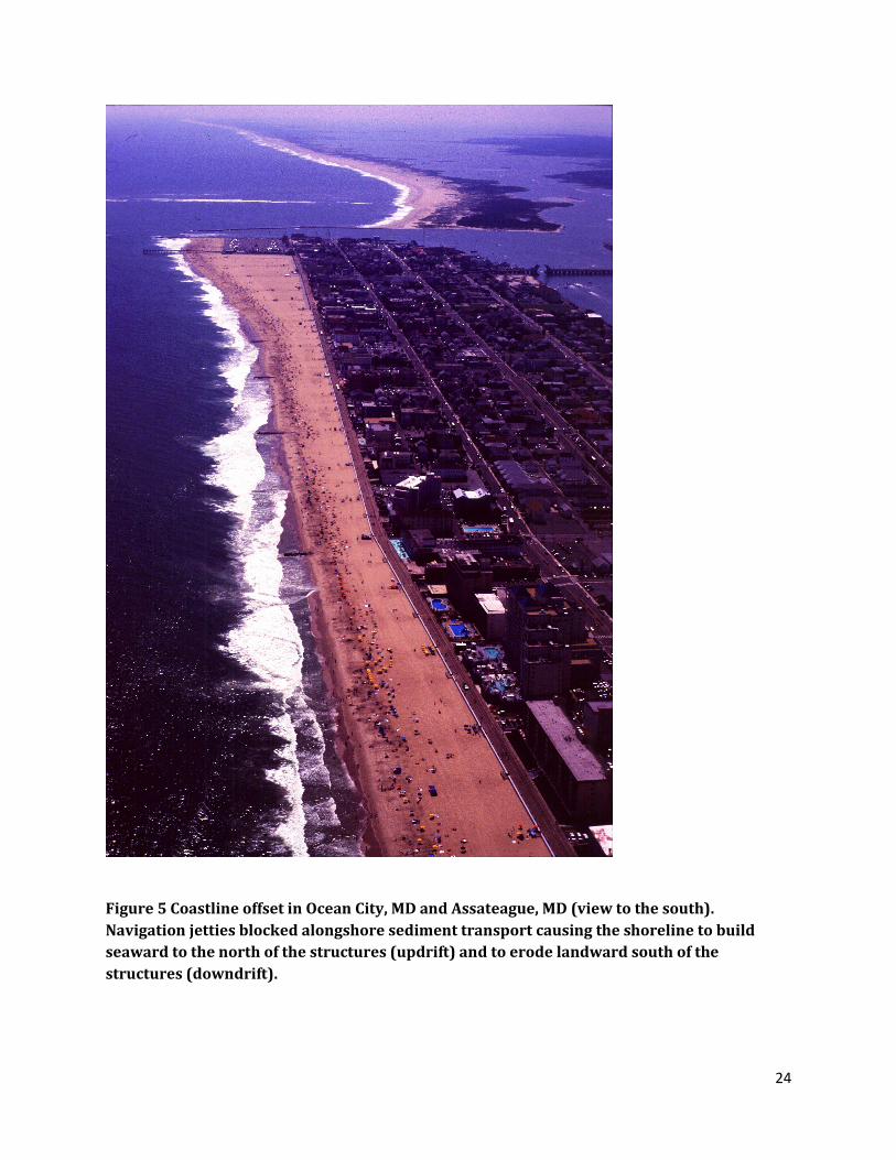
Figure 5 Coastline offset in Ocean City, MD and Assateague, MD (view to the south).
Navigation jetties blocked alongshore sediment transport causing the shoreline to build
seaward to the north of the structures (updrift) and to erode landward south of the
structures (downdrift).
25
26
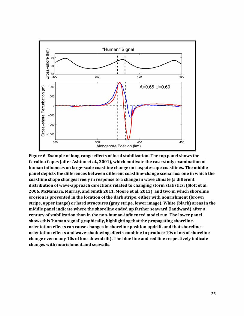
Figure 6. Example of long-range effects of local stabilization. The top panel shows the
Carolina Capes (after Ashton et al., 2001), which motivate the case-study examination of
human influences on large-scale coastline change on cuspate-cape coastlines. The middle
panel depicts the differences between different coastline-change scenarios: one in which the
coastline shape changes freely in response to a change in wave climate (a different
distribution of wave-approach directions related to changing storm statistics; (Slott et al.
2006, McNamara, Murray, and Smith 2011, Moore et al. 2013), and two in which shoreline
erosion is prevented in the location of the dark stripe, either with nourishment (brown
stripe, upper image) or hard structures (gray stripe, lower image). White (black) areas in the
middle panel indicate where the shoreline ended up farther seaward (landward) after a
century of stabilization than in the non-human-influenced model run. The lower panel
shows this ‘human signal’ graphically, highlighting that the propagating shoreline-
orientation effects can cause changes in shoreline position updrift, and that shoreline-
orientation effects and wave-shadowing effects combine to produce 10s of ms of shoreline
change even many 10s of kms downdrift). The blue line and red line respectively indicate
changes with nourishment and seawalls.
27
Figure 7. Interactions between barrier island evolution and resort communities. Hotel
density (left panel) and relative cross-shore shoreline position (right panel) are plotted
against alongshore position and time. Areas with increased density in hotels have engaged
in nourishment activities that build tall dunes to prevent overwash and widen the beach to
maintain coastline position against erosion. Both actions cause the shoreline in high-density
hotel regions to extend further seaward relative to surrounding areas with smaller hotel
densities. Over time, defending those seaward positions becomes more difficult as sand is
redistributed preferentially to concave-seaward portions of the coastline, and the lack of
overwash and associated elevation gain raises the potential hazards from severe storm
surges. Ultimately, communities are abandoned at locations that have been defended for
several decades. (From McNamara and Werner, 2008a.)
Alo
ng-s
ho
re p
ositio
n (
km
)
Time (y)
Hotel Room
Density (km-1) Relative Shoreline
Position (m)

28
Figure 8. Patterns of beach nourishment depend on background shoreline erosion rates.
Left panels (i) show beach widths at different alongshore locations through time, related to
beach nourishment activities. Right panels (ii) show the nourishment intervals that result
from an optimization calculation (Smith et al., 2009; Gopalakrishnan et al., 2011), based on
local perceptions of beach erosion rates in recent years (Lazarus et al., 2011), at each 10-km
town in the domain. In the top panels (A), nourishment intervals are uniform alongshore. In
the middle panels (B), under a relatively low shoreline erosion rates (0.5 m/yr), forcing the
middle town to nourish out of turn does not affect decisions in neighboring towns. In the
bottom panels (C), under a higher erosion rate (1.5 m/yr, which could represent the effects
of increased rates of sea-level rise), perturbing the middle town, by altering the short-term
erosion rates felt by neighboring towns, sets off a chain reaction that leads to a chaotic
spatial/temporal pattern of nourishment activities. (From Lazarus et al., 2011.)
29
Figure 9. Beach nourishment of Sandy Key, FL. Image source:
http://www.csc.noaa.gov/archived/beachnourishment/
30
Figure 10. Exhaustion of sand resources when higher property-value and lower property-
value communities exploit a common pool. Lines depict cumulative nourishment volumes
for two towns with different property values (dashed = higher property value, dotted =
lower property value, solid = total), under four different scenarios of nourishment sand
prices and spatial patterns of wealth relative to spatial patterns of background erosion
rates. The left panels depict scenarios in which the cost of sand for nourishment remains
constant through time, while the right panels show cases in which sand costs increase as the
common pool dwindles in volume. The top panels depict scenarios in which the higher
property value towns are located in areas with higher background erosion rates, while the
lower panels show the opposite spatial relationship. In these experiments, the two towns are
located near each other, but on opposite sides of a cuspate cape that is being affected by a
changing wave climate (which produces the contrasting background erosion rates). (From
McNamara et al., 2011.)