Embed Size (px)
Citation preview
FS 2C – Positioning Measurement Techniques and Applications I Ricardo Freire and José Vasconcellos Geodetic or Rhumb Line Polygon Area Calculation over the WGS-84 Datum Ellipsoid FIG Congress 2010 Facing the Challenges – Building the Capacity Sydney, Australia, 11-16 April 2010
1/13
Geodetic or Rhumb Line Polygon Area Calculation over the WGS-84 Datum Ellipsoid
Ricardo Ramos FREIRE and José Carlos Penna de VASCONCELLOS, Brazil
Key words: geodetic line, rhumb line, area calculation SUMMARY The area calculation of geodetic polygonal is a compelling mathematical challenge. How could one calculate the area of a polygon over the ellipsoid, if the sides do not have known parameterization? Some works have already been developed in order to solve this problem, employing mostly equivalent projective systems or authalic spheres approaches. Such methods near the ellipsoidal reference surface by other of easier mathematical treatment, but have limited employment, for a single surface cannot be used for the entire planet, without compromising the calculations over it. This paper aims to provide a methodology of area calculation for polygonals delimited by geodetic lines, or rhumb lines, directly on the ellipsoid, and provide a program that executes routines developed on this work. Since most geodetic surveys are developed using GPS equipment, the data input is based on (X, Y, Z) coordinates, using WGS-84 datum, providing the geodetic area without needing a GIS product. In order to achieve the paper objective, it was developed a different parameterization from the classical geometric Geodesy approach, to map the (X, Y, Z) coordinates to the geodetic ones. SUMÁRIO O cálculo da área de poligonais geodésicas é um desafio matemático instigante. Como calcular a área de uma poligonal sobre o elipsóide, se seus lados não possuem parametrização conhecida? Alguns trabalhos já foram desenvolvidos no intuito de solucionar este problema, empregando, em sua maioria, sistemas projetivos equivalentes ou aproximações sobre esferas autálicas. Tais métodos aproximam a superfície de referência elipsoidal por outras de mais fácil tratamento matemático, porém apresentam limitação de emprego, pois uma única superfície não poderia ser empregada para todo o planeta, sem comprometer os cálculos realizados sobre ela. Este trabalho visa fornecer uma metodologia de cálculo de áreas para poligonais geodésicas, ou loxodrômicas, diretamente sobre o elipsóide, bem como fornecer um programa que execute as rotinas elaboradas nesta dissertação. Como a maioria dos levantamentos geodésicos é realizada usando rastreadores GPS, a carga dos dados é pautada em coordenadas (X, Y, Z), empregando o Sistema Geodésico WGS-84, fornecendo a área geodésica sem a necessidade de um produto tipo SIG. Para alcançar o objetivo deste trabalho, foi desenvolvida parametrização diferente da abordagem clássica da Geodésia geométrica, para transformar as coordenadas (X, Y, Z) em geodésicas.

FS 2C – Positioning Measurement Techniques and Applications I Ricardo Freire and José Vasconcellos Geodetic or Rhumb Line Polygon Area Calculation over the WGS-84 Datum Ellipsoid FIG Congress 2010 Facing the Challenges – Building the Capacity Sydney, Australia, 11-16 April 2010
2/13
Geodetic or Rhumb Line Polygon Area Calculation over the WGS-84 Datum Ellipsoid
Ricardo FREIRE and José VASCONCELLOS, Brazil
1. INTRODUCTION The calculation of the geodesic polygonal area on a reference ellipsoid is a compelling mathematical challenge. A methodology for the calculation of geodesic polygonal areas that were developed directly on the ellipsoid, without plane approximations, authalic spheres or any other simplifications of the reference surface would provide a clear determination of the area of certain portion of the planet. Some commercial solutions have different methodologies to solve the area problem, as follows:
− the mathematical package MATLAB 2009B has a function AREAINT that allows the area calculation of polygonal over an ellipsoid by using the authalic sphere and line integral based on Green's theorem. There is no reference about accuracy of the model;
− Oracle Spatial 11g when calculating the area of half ellipsoid using SDO_AREA function, presents an error of 0.1% (Kothur, Godfrind, BEINAT, 2007). Smaller areas have greater precision. There is no mention about the method used to calculate the areas;
− the Blue Marble Geogaphics company developed GeoCalc.NET 6.3, which allows the calculation of geodetic polygonal area through the method PolygonArea. There are no references about methodology or accuracy;
− the CARIS-UNIVERSAL SYSTEMS LTD created the solution CARIS HPD (Hydrographic Production Database) that is beginning to be employed at Centro de Hidrografia da Marinha, outside production environment, for storing and updating nautical charts. This solution features tools that can calculate geodetic polygonal areas ,or rhumb ones, in "real" time (LÉVESQUE, COCKBURN, MCLEAY, 2008).
2. OBJECTIVE Establish a mathematical model to calculate geodetic polygon areas from its vertices X, Y, Z geocentric coordinates, referred to the WGS-84 and polygon areas whose sides are rhumb lines.

FS 2C – Positioning Measurement Techniques and Applications I Ricardo Freire and José Vasconcellos Geodetic or Rhumb Line Polygon Area Calculation over the WGS-84 Datum Ellipsoid FIG Congress 2010 Facing the Challenges – Building the Capacity Sydney, Australia, 11-16 April 2010
3/13
3. MODELING ELLIPSOIDAL GEOMETRY FOR MATHEMATICAL
TREATMENT OF COORDINATES SURVEYED ON GPS SYSTEM 3.1 XGPS, YGPS, ZGPS coordinates reduction over the ellipsoid
Let (3.1) be the equation of ellipsoid S, represented below:
If the h distance between the ellipsoid and the point of coordinates (XGPS, YGPS, ZGPS)
is minimal, we have:
Using the concept of Lagrange multipliers, combining (3.2) and (3.1) by the constant ML, nonzero, we obtain:
It was chosen the Newton-Raphson numerical method to calculate ML. 3.2 Ellipsoidal parameterization by curvilinear coordinates
Figure 1 – Geocentric and geodetic ellipsoidal parameterization

FS 2C – Positioning Measurement Techniques and Applications I Ricardo Freire and José Vasconcellos Geodetic or Rhumb Line Polygon Area Calculation over the WGS-84 Datum Ellipsoid FIG Congress 2010 Facing the Challenges – Building the Capacity Sydney, Australia, 11-16 April 2010
4/13
Looking at Figure 6, there are several relationships between d, d1, d2, latitude and longitude (geodetic and
geocentric ones), as following:
Thus, it is possible to rewrite the parameterization for X, Y and Z based on curvilinear geocentric
coordinates:
4. SUPPORT METHODOLOGY TO CALCULATE POLAR ELLIPSOIDAL
TRIANGLES AREAS 4.1 Calculation ellipsoid total area It was used the concept of surface integrals, as follows:

FS 2C – Positioning Measurement Techniques and Applications I Ricardo Freire and José Vasconcellos Geodetic or Rhumb Line Polygon Area Calculation over the WGS-84 Datum Ellipsoid FIG Congress 2010 Facing the Challenges – Building the Capacity Sydney, Australia, 11-16 April 2010
5/13
The Area2 value will be:
The area calculated for the reference ellipsoid (WGS-84) is 510065621724088.44 m2. One could find similar value using classical formulations of Geodesy, as 510065621.7 km2 for the GRS80 ellipsoid (RAPP, 1991). 4.2 Polar ellipsoidal triangle area
Adapting Gauss polygonal area calculation method for the ellipsoidal case, where the
coordinate system is curvilinear, the side of a polygon is delimited by two meridian. Since
meridians converge toward the poles, the area between the trapezoidal flat side of the polygon
and the horizontal axis defined will have its ellipsoid equivalent in the figure of a polar
triangle. Each polar triangle can be evaluated by (4.7). For this study, it was chosen the South
Pole as a reference. The total sum of triangles areas results in the area of the polygon.
Based on Vincenty’s direct and inverse approach, there were created four functions: DistGeod, Azimuth, Latitude, and Longitude. DistGeod calculates the geodesic distance between two points and Azimuth calculates the forward geodetic azimuth between them. From geodetic coordinates of a point, the distance between him and the next point and its forward geodetic azimuth, it is possible to calculate the coordinates of the second point through the functions Latitude and Longitude. 4.3 Simplifying the polar ellipsoidal triangles area calculation
It was created the function func (φ), based on WGS-84 parameters:
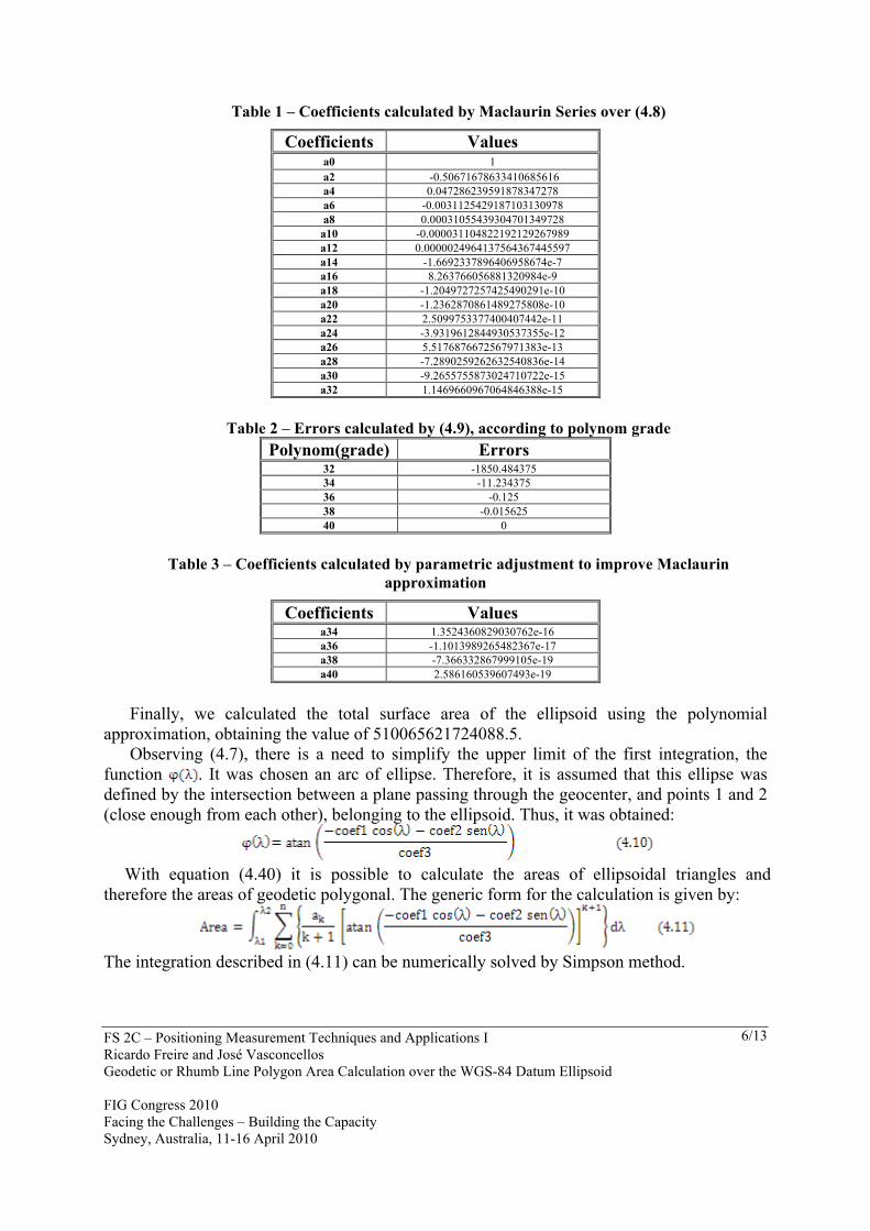
Using Taylor Series, one could calculate even coefficients until level 32 (limit of Mathcad expansion) . The odd coefficients are all zero.
When performing (4.8) and teste( ) function integration between -90º e 90º limits, there were found differences of -1850,484375 m2 from the equation bellow:
It was used parametric adjustment by minimal square, to obtain coefficients that would
improve polynomial modeling.
FS 2C – Positioning Measurement Techniques and Applications I Ricardo Freire and José Vasconcellos Geodetic or Rhumb Line Polygon Area Calculation over the WGS-84 Datum Ellipsoid FIG Congress 2010 Facing the Challenges – Building the Capacity Sydney, Australia, 11-16 April 2010
6/13
Table 1 – Coefficients calculated by Maclaurin Series over (4.8)
Coefficients Values a0 1 a2 -0.50671678633410685616 a4 0.047286239591878347278 a6 -0.0031125429187103130978 a8 0.00031055439304701349728
a10 -0.000031104822192129267989 a12 0.0000024964137564367445597 a14 -1.6692337896406958674e-7 a16 8.263766056881320984e-9 a18 -1.2049727257425490291e-10 a20 -1.2362870861489275808e-10 a22 2.5099753377400407442e-11 a24 -3.9319612844930537355e-12 a26 5.5176876672567971383e-13 a28 -7.2890259262632540836e-14 a30 -9.2655755873024710722e-15 a32 1.1469660967064846388e-15
Table 2 – Errors calculated by (4.9), according to polynom grade
Polynom(grade) Errors 32 -1850.484375 34 -11.234375 36 -0.125 38 -0.015625 40 0
Table 3 – Coefficients calculated by parametric adjustment to improve Maclaurin
approximation
Coefficients Values a34 1.3524360829030762e-16 a36 -1.1013989265482367e-17 a38 -7.366332867999105e-19 a40 2.586160539607493e-19
Finally, we calculated the total surface area of the ellipsoid using the polynomial
approximation, obtaining the value of 510065621724088.5. Observing (4.7), there is a need to simplify the upper limit of the first integration, the
function . It was chosen an arc of ellipse. Therefore, it is assumed that this ellipse was defined by the intersection between a plane passing through the geocenter, and points 1 and 2 (close enough from each other), belonging to the ellipsoid. Thus, it was obtained:
With equation (4.40) it is possible to calculate the areas of ellipsoidal triangles and
therefore the areas of geodetic polygonal. The generic form for the calculation is given by:
The integration described in (4.11) can be numerically solved by Simpson method.

FS 2C – Positioning Measurement Techniques and Applications I Ricardo Freire and José Vasconcellos Geodetic or Rhumb Line Polygon Area Calculation over the WGS-84 Datum Ellipsoid FIG Congress 2010 Facing the Challenges – Building the Capacity Sydney, Australia, 11-16 April 2010
7/13
5. INTRODUCTION 5.1 Data preparation
Loading matrix Geodesic, the number of lines n is the number of points on the polygonal, as the number of columns equals to two. The first column of the matrix will have the geodetic latitudes, and the second column, the longitudes.
A vector is created only with the longitudes, it is determined the lowest value and decreases the value of all elements of the second column of the array Geodesic, storing the new values, all positive, as the geodesic longitudes to be used. Using the DistGeod function, it is stored a vector with the geodetic distances between points. The same process is performed with the Azimuth function, storing the values of geodetic azimuths in another vector. 5.2 Coordinates determination of points belonging to a geodetic line
To grow up the density of points belonging to the geodesic line, it was used a combination of Direct and Inverse methods (Vincenty, 1975). To divide the geodesic segments with equal length, it was settled a step value, which would be used in accordance with the size of the geodesic line. This step would automatically vary between 20 km to 1 m, thus meeting polygonal with different lengths of sides. It is noteworthy that the same polygon can have different steps, according to the length of its geodesic sides. From the geodetic coordinates now spaced according to the step chosen for each side, one must calculate their geocentric coordinates, which are stored in an array called Geocentric. 5.3 Geodetic polygonal area calculation Since Geocentric is fulfilled, it is possible to calculate the area of the geodesic polygon by adding up the values calculated in (4.11) for all terms belonging to that matrix. But first it is necessary to create some functions. The first is called Primitive40, which is the integration of the Taylor expansion of (4.30).
The even terms of (5.1) assume zero values. Then, it creates the Ellipse function, based on (4.10):
One should recall that the values of coefficients in (5.2) depend on the pairs of adjacent (consecutive) points (geocentric coordinates) stored in the Geocentric matrix. Then, the function s is created, as follows:
FS 2C – Positioning Measurement Techniques and Applications I Ricardo Freire and José Vasconcellos Geodetic or Rhumb Line Polygon Area Calculation over the WGS-84 Datum Ellipsoid FIG Congress 2010 Facing the Challenges – Building the Capacity Sydney, Australia, 11-16 April 2010
8/13
It is created the Simpson function, which will calculate the integration. To calculate the geodetic polygon área, one should sum up all values evaluated to each pair of points (created when growing up the geodetic line density of points) by Simpson’s Method. 5.4 Rhumb line adaptation Being the Mercator projection equatorial and conform, it was used for the density growth of the polygon points. The first step is an assessment of the extent of the latitudes of points in the polygon. By choosing the maximum and minimum value, take the average between them and calculate the latitude of reference, called . To calculate the coordinates in Mercator projection from the geodetic coordinates, we have:
Where e1 is the first eccentricity. To determine the geodetic coordinates from the plane coordinates in Mercator projection, there were created the functions longlox and latlox. The inverse function to calculate the geodetic longitude of the point belonging to the rhumb line is quite simple, as can be seen in (5.4). However, the calculation of latitude is more complex, needing to create a function Func. This function would have zero value on the latitude of the point. It was used Newton-Raphson approach, which required the calculation of the derivative of Func at the point of interest, creating the function DerivFunc. Those functions are defined as following:
We must now calculate and store the distances and azimuths, calculated on the Mercator projection, between the points that are adjacent in the Geodesic matrix. To this end, two vectors are created, the Distâncias_loxo and Az_loxo. Similarly to the method used to create the Geodesic2 matrix, the matrix Rhumb is defined to store the coordinates of the points belonging to dense polygonal sides of the rhumb. Since Rhumb matrix is fulfilled, it must calculate the geocentric coordinates counterparts in the matrix Geocentric_Rhumb, similar to the matrix Geocentric. Finally, to calculate the area of loxodromic polygonal, it uses again the sum of each pair of points from the integration by Simpson. 6. RESULTS
The first test was conducted for five points on the Equator, equally spaced. The known coordinates of these points are represented in the table below:

FS 2C – Positioning Measurement Techniques and Applications I Ricardo Freire and José Vasconcellos Geodetic or Rhumb Line Polygon Area Calculation over the WGS-84 Datum Ellipsoid FIG Congress 2010 Facing the Challenges – Building the Capacity Sydney, Australia, 11-16 April 2010
9/13
Table 4 – Coordinates of points that define Polygon 1
Points X Y Z P1 6378137 0 0 P2 1970952.725 6065968.756 0 P3 -5160021.225 3748974.866 0 P4 -5160021.225 -3748974.866 0 P5 1970952.725 -6065968.756 0
Based on the results obtained previously, the area of half of the ellipsoid used is equal to
255032810862044.22 m2. Calculating the same area with the methodology of this paper, it was obtained 255032810862034.44 m2. For an area equivalent to half the planet, you get precision of 38 ppq (parts per quadrillion) and is calculated in less than two seconds on the workstation used for modeling. It is recalled that ORACLE SPATIAL 11g introduces an error of 0.1% when calculating the same area through its SDO_AREA.
As the Equator is also a rhumb line, the same methodology was applied to a polygonal rhumb, obtaining value of 255032810862034.22 m2. This result gives accuracy of 39 ppq. To better support the evaluation of results, the areas of geodesic polygonal were compared with the results offered by the solution Hydrographic Production Database (HPD) of CARIS. It was created some other polygonal geodesic, detailed below.
Table 5 – Coordinates of points that define Polygon 2
Points Latitude Longitude P1 0° -66° P2 0° -65° P3 -1° -65° P4 -1° -66° P5 0° -66°
Table 6 – Coordinates of points that define Polygon 3
Points Latitude Longitude P1 -68° -66° P2 -68° -65° P3 -67° -65° P4 -67° -66° P5 -68° -66°
Table 7 – Coordinates of points that define Polygon 4
Points Latitude Longitude P1 9° -53.68° P2 9° -52° P3 -38° -52° P4 -38° -53.68° P5 9° -53.68°

FS 2C – Positioning Measurement Techniques and Applications I Ricardo Freire and José Vasconcellos Geodetic or Rhumb Line Polygon Area Calculation over the WGS-84 Datum Ellipsoid FIG Congress 2010 Facing the Challenges – Building the Capacity Sydney, Australia, 11-16 April 2010
10/13
Table 8 – Coordinates of points that define Polygon 5
Points Latitude Longitude P1 28.6362365° 0° P2 -21.4366965° 64.2086651° P3 4.9898034° 119.491462° P4 33.8288302° 100.7759318° P5 19.6663563° 77.7414331° P6 37.5849405° 65.0724588° P7 40.7225762° 33.4000231° P8 28.6362365° 0°
Table 10 – Coordinates of points that define Polygon 6
Points Latitude Longitude P1 0° 0° P2 0° 11° P3 -90° 11° P4 -90° 0° P5 0° 0°
All polygons were created to verify the level of adhesion between the geodetic method of areas calculation used in the CARIS platform against the methodology presented in this paper. Table 11 compares the area values of the polygonal 2 to 5, with adjustable step limited to 20 kilometers, the values calculated by CARIS, the internal precision achieved between steps of 200 meters and 20 kilometers, and the accuracies between CARIS and methodology of this paper.
Table 11 – Polygon area calculation and its respective precisions
Polygon Paper Area CARIS Area Precision between steps
CARIS versus paper
2 12308778361.46 12308778798.98 0.43ppt 35.55ppb 3 4764521310.60 4764521767.77 22.62ppb 95.95ppb 4 916107764479.79 916107767925.56 4.36ppb 3.76ppb 5 47187272237071.78 47186908662362.30 3.93ppb 7.70ppm
By observing the area values in Table 11, and the precision between CARIS solution and
the paper’s one, it is quite clear that both solutions converge to practically identical values. About the steps simplification used in this work, the third column shows that the density
of coordinates with 200 meters step would merely increase the cost of processing, not generating significant gain in accuracy. Although Table 11 indicates the high degree of adhesion between CARIS platform and this work, it should assess the relative accuracy of both area against a known value, such as the Polygon 6.
Table 12 – Results to Polygon 6
Métodos Area Precision againt half fuse área of 11°
Precision against 200m step
Paper 7792669220784.71 3.38ppq 43ppq CARIS 7792666987951.76 0.29ppm -
Calculus 7792669220784.69 0 -
FS 2C – Positioning Measurement Techniques and Applications I Ricardo Freire and José Vasconcellos Geodetic or Rhumb Line Polygon Area Calculation over the WGS-84 Datum Ellipsoid FIG Congress 2010 Facing the Challenges – Building the Capacity Sydney, Australia, 11-16 April 2010
11/13
Analyzing Table 12, it shows that the area calculated by the paper methodology is more
accurate than that provided by CARIS, and highlights, once again, the internal accuracy of results, despite the use of a step of 200 meters or 20 kilometers, which ensures greatly decrease processing time, without loss of final precision.
To analyze the behavior of the methodology for a very small area, it was created the Polygonal 7.
Table 13 – Coordinates of points that define Polygon 7
Points Latitude Longitude P1 0° 0° P2 0° 0.0001° P3 0.0001° 0.0001° P4 0.0001° 0° P5 0° 0°
Table 14 stores the values of points of Polygon 7 in the cylindrical equivalent projection, with standard parallel and the central meridian equal to 0°.
Table 14 – Projeted coordinates of Polygonal 7
Points N(m) E(m) P1 0 0 P2 0 11.13194907932736 P3 11.05742758196920 11.13194907932736 P4 11.05742758196920 0 P5 0 0
The result was 123.09072079083099 m2. Applying paper methodology, the calculated value was 123.09072080254555m2. The inner precision is 95.17ppt. That way, it is proved the methodology flexibility to calculate areas of almost any dimensions. 7. CONCLUSION
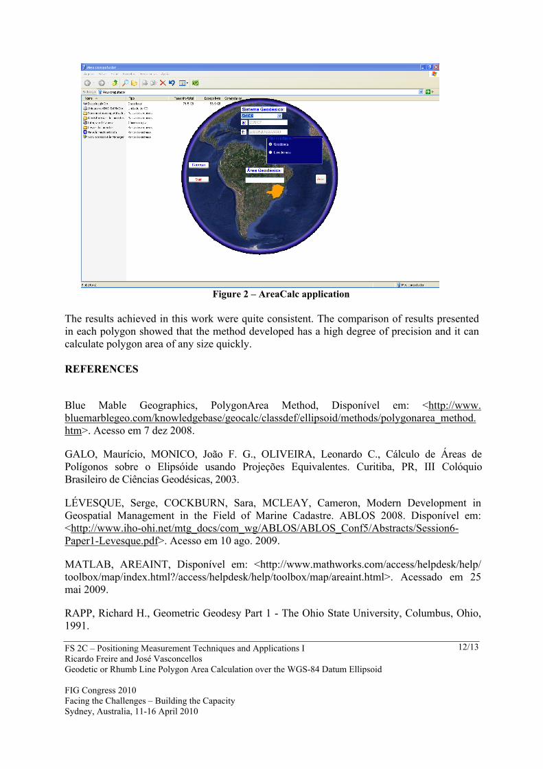
Through the procedures presented, it was provided a method for area calculation directly over ellipsoidal geodetic reference. Based on the methodology presented it was developed in Visual Basic 2008 a program, which allows code to be more easily adapted to any Geographic Information System. Below is an image of the interface created for the area calculation.
FS 2C – Positioning Measurement Techniques and Applications I Ricardo Freire and José Vasconcellos Geodetic or Rhumb Line Polygon Area Calculation over the WGS-84 Datum Ellipsoid FIG Congress 2010 Facing the Challenges – Building the Capacity Sydney, Australia, 11-16 April 2010
12/13
Figure 2 – AreaCalc application
The results achieved in this work were quite consistent. The comparison of results presented in each polygon showed that the method developed has a high degree of precision and it can calculate polygon area of any size quickly. REFERENCES
Blue Mable Geographics, PolygonArea Method, Disponível em: <http://www. bluemarblegeo.com/knowledgebase/geocalc/classdef/ellipsoid/methods/polygonarea_method.htm>. Acesso em 7 dez 2008.
GALO, Maurício, MONICO, João F. G., OLIVEIRA, Leonardo C., Cálculo de Áreas de Polígonos sobre o Elipsóide usando Projeções Equivalentes. Curitiba, PR, III Colóquio Brasileiro de Ciências Geodésicas, 2003.
LÉVESQUE, Serge, COCKBURN, Sara, MCLEAY, Cameron, Modern Development in Geospatial Management in the Field of Marine Cadastre. ABLOS 2008. Disponível em: <http://www.iho-ohi.net/mtg_docs/com_wg/ABLOS/ABLOS_Conf5/Abstracts/Session6-Paper1-Levesque.pdf>. Acesso em 10 ago. 2009.
MATLAB, AREAINT, Disponível em: <http://www.mathworks.com/access/helpdesk/help/ toolbox/map/index.html?/access/helpdesk/help/toolbox/map/areaint.html>. Acessado em 25 mai 2009.
RAPP, Richard H., Geometric Geodesy Part 1 - The Ohio State University, Columbus, Ohio, 1991.
FS 2C – Positioning Measurement Techniques and Applications I Ricardo Freire and José Vasconcellos Geodetic or Rhumb Line Polygon Area Calculation over the WGS-84 Datum Ellipsoid FIG Congress 2010 Facing the Challenges – Building the Capacity Sydney, Australia, 11-16 April 2010
13/13
VINCENTY, T., Direct and Inverse Solutions of Geodesics on the Ellipsoid with application of nested equations, Survey Review, XXII, 176, p.88-93, 1975. WELLS, D. E., KRAKIWSKY, E. J., The Method of Least Squares, Department of Geodesy and Geomatics Engineering, University of New Brunswick, 1997. Lectures Notes 18. CONTACTS Eng Ricardo Ramos Freire Centro de Hidrografia da Marinha Rua Barão de Jaceguai, S/N, Ponta da Armação Niterói BRAZIL Tel. +55 21 21893084 Fax + 55 21 21893242 Email: [email protected] Web site: http://bwww.dhn.mar.mil.br DSc José Carlos Penna de Vasconcellos Universidade do Estado do Rio de Janeiro Rua São Francisco Xavier, 524, Maracanã Rio de Janeiro BRAZIL Tel. +55 21 25877261 Email: [email protected] Web site: http://www.geomatica.eng.uerj.br/docente/vasconcellos/