Embed Size (px)
Citation preview
GeoDCAT-AP: A geospatial extension for the DCAT
application profile for data portals in Europe
Version 1.0.1
GeoDCAT-AP: A geospatial extension for the DCAT application profile for data portals in Europe
Page 2 of 87
GeoDCAT-AP v1.0.1, 2016-08-02
Document Metadata
Date 2016-08-02
Status Final
Version 1.0.1
Access
URL
https://joinup.ec.europa.eu/node/154143/
Rights © 2015 European Union
Licence ISA Open Metadata Licence v1.1, retrievable from
https://joinup.ec.europa.eu/category/licence/isa-open-metadata-
licence-v11.
Disclaimer:
This specification was prepared for the ISA Programme by: PwC EU Services.
The views expressed in this specification are purely those of the authors and may not,
in any circumstances, be interpreted as stating an official position of the European
Commission.
The European Commission does not guarantee the accuracy of the information included
in this study, nor does it accept any responsibility for any use thereof.
Reference herein to any specific products, specifications, process, or service by trade
name, trademark, manufacturer, or otherwise, does not necessarily constitute or imply
its endorsement, recommendation, or favouring by the European Commission.
All care has been taken by the author to ensure that s/he has obtained, where
necessary, permission to use any parts of manuscripts including illustrations, maps, and
graphs, on which intellectual property rights already exist from the titular holder(s) of
such rights or from her/his or their legal representative.
Note on this document (2016-08-02)
This version of the GeoDCAT-AP 1.0 has been amended with respect to the original one
in order to correct a typo concerning the URIs of the code lists of the INSPIRE Registry.
No other changes have been done on the original specification.
GeoDCAT-AP: A geospatial extension for the DCAT application profile for data portals in Europe
Page 3 of 87
GeoDCAT-AP v1.0.1, 2016-08-02
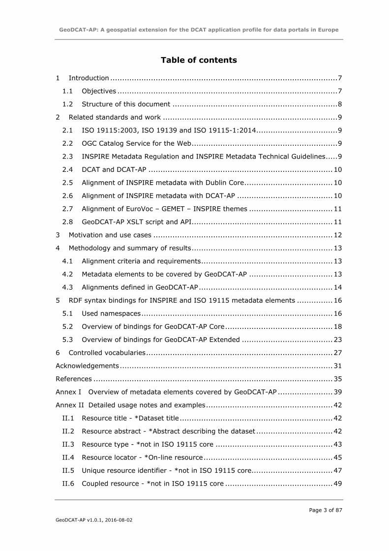
Table of contents
1 Introduction ............................................................................................... 7
1.1 Objectives ............................................................................................ 7
1.2 Structure of this document ..................................................................... 8
2 Related standards and work ......................................................................... 9
2.1 ISO 19115:2003, ISO 19139 and ISO 19115-1:2014 .................................. 9
2.2 OGC Catalog Service for the Web ............................................................. 9
2.3 INSPIRE Metadata Regulation and INSPIRE Metadata Technical Guidelines ..... 9
2.4 DCAT and DCAT-AP ............................................................................. 10
2.5 Alignment of INSPIRE metadata with Dublin Core ..................................... 10
2.6 Alignment of INSPIRE metadata with DCAT-AP ........................................ 10
2.7 Alignment of EuroVoc – GEMET – INSPIRE themes ................................... 11
2.8 GeoDCAT-AP XSLT script and API ........................................................... 11
3 Motivation and use cases ........................................................................... 12
4 Methodology and summary of results ........................................................... 13
4.1 Alignment criteria and requirements ....................................................... 13
4.2 Metadata elements to be covered by GeoDCAT-AP ................................... 13
4.3 Alignments defined in GeoDCAT-AP ........................................................ 14
5 RDF syntax bindings for INSPIRE and ISO 19115 metadata elements ............... 16
5.1 Used namespaces ................................................................................ 16
5.2 Overview of bindings for GeoDCAT-AP Core ............................................. 18
5.3 Overview of bindings for GeoDCAT-AP Extended ...................................... 23
6 Controlled vocabularies .............................................................................. 27
Acknowledgements ......................................................................................... 31
References .................................................................................................... 35
Annex I Overview of metadata elements covered by GeoDCAT-AP ....................... 39
Annex II Detailed usage notes and examples ..................................................... 42
II.1 Resource title - *Dataset title ................................................................ 42
II.2 Resource abstract - *Abstract describing the dataset ................................ 42
II.3 Resource type - *not in ISO 19115 core ................................................. 43
II.4 Resource locator - *On-line resource ...................................................... 45
II.5 Unique resource identifier - *not in ISO 19115 core.................................. 47
II.6 Coupled resource - *not in ISO 19115 core ............................................. 49
GeoDCAT-AP: A geospatial extension for the DCAT application profile for data portals in Europe
Page 4 of 87
GeoDCAT-AP v1.0.1, 2016-08-02
II.7 Resource language and metadata language - *Dataset language and Metadata
language .................................................................................................... 50
II.8 Topic category, originating controlled vocabulary, and keyword value -
*Dataset topic category ................................................................................ 51
II.8.1 Topic category and keyword in datasets and dataset series .................. 52
II.8.2 Keyword in services........................................................................ 53
II.9 Spatial data service type - *not in ISO 19115 core ................................... 57
II.10 Geographic bounding box - *Geographic location of the dataset (by 4
coordinates or by geographic identifier) .......................................................... 57
II.11 Temporal reference and metadata date –*Additional extent information for the
dataset (vertical and temporal) and *Metadata date stamp ................................ 59
II.12 Lineage - *Lineage .............................................................................. 61
II.13 Spatial resolution – Spatial resolution of the dataset ................................. 62
II.14 Conformity and data quality - *not in ISO 19115 core .............................. 63
II.15 Conditions for access and use and limitations on public access – Use limitation
and access / other constraints ....................................................................... 65
II.16 Responsible party and metadata point of contact - *Dataset responsible party
and *Metadata point of contact ...................................................................... 66
II.17 *Metadata file identifier ........................................................................ 70
II.18 *Metadata standard name, *Metadata standard version ............................ 70
II.19 *Metadata characterset ........................................................................ 72
II.20 Metadata point of contact - *Metadata point of contact ............................. 72
II.21 Metadata date - *Metadata date stamp ................................................... 72
II.22 Metadata language - *Metadata language ............................................... 72
II.23 Coordinate reference systems and Temporal reference systems – *Reference
System ...................................................................................................... 72
II.24 Character encoding - *Dataset character set and *Metadata character set ... 74
II.25 Encoding - *Distribution format ............................................................. 77
II.26 Spatial representation type – *Spatial representation type ........................ 78
II.27 Maintenance information - *not in ISO 19115 core ................................... 79
Annex III Comparison between INSPIRE and ISO 19115-1:2014 ........................... 81
III.1 Spatial dataset and spatial dataset series ................................................ 81
III.2 Services ............................................................................................. 84
GeoDCAT-AP: A geospatial extension for the DCAT application profile for data portals in Europe
Page 5 of 87
GeoDCAT-AP v1.0.1, 2016-08-02
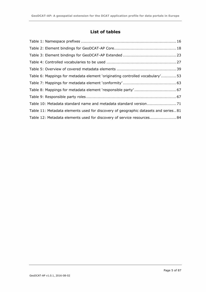
List of tables
Table 1: Namespace prefixes ........................................................................... 16
Table 2: Element bindings for GeoDCAT-AP Core ................................................. 18
Table 3: Element bindings for GeoDCAT-AP Extended .......................................... 23
Table 4: Controlled vocabularies to be used ....................................................... 27
Table 5: Overview of covered metadata elements ............................................... 39
Table 6: Mappings for metadata element ‘originating controlled vocabulary’ ............ 53
Table 7: Mappings for metadata element ‘conformity’ .......................................... 63
Table 8: Mappings for metadata element ‘responsible party’ ................................. 67
Table 9: Responsible party roles ....................................................................... 67
Table 10: Metadata standard name and metadata standard version ....................... 71
Table 11: Metadata elements used for discovery of geographic datasets and series .. 81
Table 12: Metadata elements used for discovery of service resources ..................... 84
GeoDCAT-AP: A geospatial extension for the DCAT application profile for data portals in Europe
Page 6 of 87
GeoDCAT-AP v1.0.1, 2016-08-02
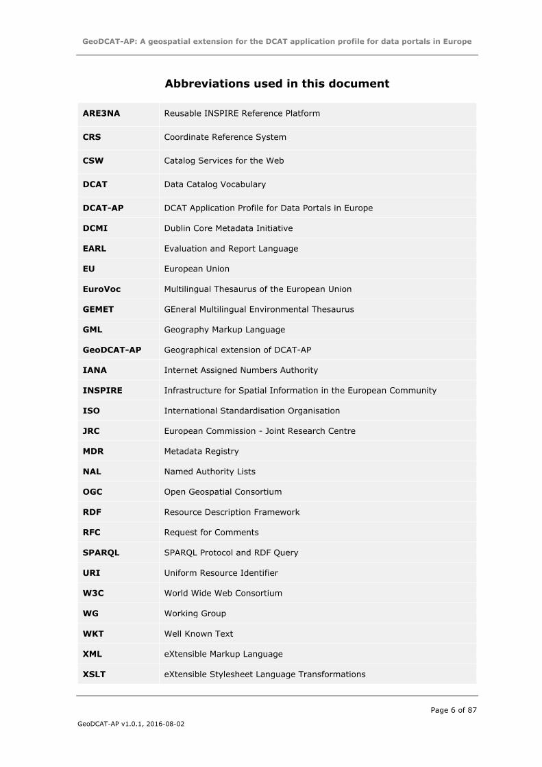
Abbreviations used in this document
ARE3NA Reusable INSPIRE Reference Platform
CRS Coordinate Reference System
CSW Catalog Services for the Web
DCAT Data Catalog Vocabulary
DCAT-AP DCAT Application Profile for Data Portals in Europe
DCMI Dublin Core Metadata Initiative
EARL Evaluation and Report Language
EU European Union
EuroVoc Multilingual Thesaurus of the European Union
GEMET GEneral Multilingual Environmental Thesaurus
GML Geography Markup Language
GeoDCAT-AP Geographical extension of DCAT-AP
IANA Internet Assigned Numbers Authority
INSPIRE Infrastructure for Spatial Information in the European Community
ISO International Standardisation Organisation
JRC European Commission - Joint Research Centre
MDR Metadata Registry
NAL Named Authority Lists
OGC Open Geospatial Consortium
RDF Resource Description Framework
RFC Request for Comments
SPARQL SPARQL Protocol and RDF Query
URI Uniform Resource Identifier
W3C World Wide Web Consortium
WG Working Group
WKT Well Known Text
XML eXtensible Markup Language
XSLT eXtensible Stylesheet Language Transformations
GeoDCAT-AP: A geospatial extension for the DCAT application profile for data portals in Europe
Page 7 of 87
GeoDCAT-AP v1.0.1, 2016-08-02
1 INTRODUCTION
This document contains the specification for GeoDCAT-AP, an extension of the DCAT
application profile for data portals in Europe (DCAT-AP) [DCAT-AP] for describing
geospatial datasets, dataset series, and services.
Its basic use case is to make spatial datasets, dataset series, and services searchable
on general data portals, thereby making geospatial information better searchable across
borders and sectors. This can be achieved by the exchange of descriptions of data sets
among data portals. GeoDCAT-AP provides an RDF syntax binding for the union of
metadata elements of the core profile of ISO 19115:2003 [ISO19115] and those defined
in the framework of the INSPIRE Directive [INSPIRE-DIR].
The GeoDCAT-AP specification does not replace the INSPIRE Metadata
Regulation [INSPIRE-MD-REG] nor the INSPIRE Metadata technical guidelines
[INSPIRE-MD-TG] based on ISO 19115 and ISO 19119. Its purpose is to give
owners of geospatial metadata the possibility to achieve more by providing the means
of an additional implementation through harmonised RDF syntax bindings. Conversion
rules to RDF syntax would allow Member States to maintain their collections of INSPIRE-
relevant datasets following the INSPIRE Metadata technical guidelines based on
ISO 19115 and ISO 19119 [ISO19119], while at the same time publishing these
collections on DCAT-AP-conformant data portals. A conversion to RDF syntax allows
additional metadata elements to be displayed on general-purposed data portals,
provided that such data portals are capable of displaying additional metadata elements.
Additionally, data portals may be capable of providing machine-to-machine interfaces
where additional metadata could be provided.
1.1 Objectives
The objective of this work is to define an RDF syntax that can be used for the exchange
of descriptions of spatial datasets, dataset series, and services among data portals. The
RDF syntax should extend the DCAT Application Profile for data portals in Europe [DCAT-
AP].
To provide an RDF syntax binding for the union of the elements in the INSPIRE
metadata schema and the core profile of ISO 19115:2003. The guiding design
principle is to make the resulting RDF syntax as simple as possible; thereby
maximally using existing RDF vocabularies – such as the Dublin Core and DCAT-
AP –, and as much as possible avoiding minting new terms. The defined syntax
binding must enable the conversion of metadata records from ISO 19115 /
INSPIRE to a harmonised RDF representation. The ability to convert metadata
records from RDF to ISO 19115 / INSPIRE is not a requirement.
To formulate recommendations to the Working Group dealing with the revision
of the DCAT-AP, to maximally align DCAT-AP and GeoDCAT-AP.
GeoDCAT-AP: A geospatial extension for the DCAT application profile for data portals in Europe
Page 8 of 87
GeoDCAT-AP v1.0.1, 2016-08-02
To take into account and refer to alignment of relevant controlled vocabularies
(e.g., the alignments between GEMET, INSPIRE themes, EuroVoc carried out by
the Publications Office of the EU1).
Additionally, the following outcomes may be achieved, outside the context of this
specification:
To define new controlled vocabularies or define mappings between controlled
vocabularies;
To design executable transformation rules (i.e., an XSLT script [GEODCAT-
XSLT]), as a reference implementation of the mappings defined in the GeoDCAT-
AP specification.
To define an RDF syntax binding for the elements in ISO 19115-1:2014.
1.2 Structure of this document
This document consists of the following sections:
Section 1 introduces this document;
Section 2 provides an overview of related work;
Section 3 provides the use cases that motivate the creation of a GeoDCAT-AP
specification;
Section 4 provides a description of the methodology used in terms of alignment
of criteria and requirement, metadata elements covered by GeoDCAT-AP, and a
summary of the results;
Section 5 provides the suggested RDF syntax bindings for metadata elements;
Section 6 provides an overview of controlled vocabularies with relevant URI sets;
This specification is accompanied by a set of annexes, providing additional reference
and support material. More precisely:
Annex I provides a summary of the INSPIRE and ISO 19115 elements covered
by GeoDCAT-AP;
Annex II provides detailed usage notes and examples for each of the metadata
elements covered by GeoDCAT-AP;
Annex III carries out a comparison of INSPIRE metadata with ISO 19115-
1:2014.
1 http://publications.europa.eu/mdr/eurovoc/
GeoDCAT-AP: A geospatial extension for the DCAT application profile for data portals in Europe
Page 9 of 87
GeoDCAT-AP v1.0.1, 2016-08-02
2 RELATED STANDARDS AND WORK
This section contains an overview of related standards and work.
2.1 ISO 19115:2003, ISO 19139 and ISO 19115-1:2014
ISO 19115:2003 [ISO19115], a standard of the International Organization for
Standardization (ISO), defines how to describe geographical information. ISO 19139
[ISO19139] defines the XML-based implementation for ISO 19115.
ISO 19115-1:2014 [ISO19115-1] has superseded ISO 19115:2003. At the date of
publication of this document, the XML-based implementation of ISO 19115-1:2014
(namely, ISO 19115-3), was finalised but not yet officially released. Annex III contains
an overview of the most important changes.
As documented in the INSPIRE Metadata Technical Guidelines [INSPIRE-MD-TG], the
conformance of a metadata set to the core profile of ISO 19115 does not guarantee
conformance to the INSPIRE metadata specifications, although there is a large
correspondence.
2.2 OGC Catalog Service for the Web
Catalog Service for the Web (CSW) [CSW] is a standard of the Open Geospatial
Consortium (OGC) for exposing a catalogue of geospatial records on the Web. It
specifies the interfaces, bindings, and a framework for defining application profiles
required to publish and access digital catalogues of metadata for geospatial data,
services, and related resource information.
A profile of CSW is used in the INSPIRE Technical Guidance on Discovery Services
[INSPIRE-DS-TG].
2.3 INSPIRE Metadata Regulation and INSPIRE Metadata Technical
Guidelines
The INSPIRE Metadata Technical Guidelines [INSPIRE-MD-TG] include rules for the
description of resources based on ISO 19115 (datasets and series) and ISO 19119
(services), and by using their XML-based implementation defined in ISO 19139.
INSPIRE2 [INSPIRE-DIR] is a Directive of the European Parliament and of the Council
aiming to establish a EU-wide spatial data infrastructure to give cross-border access to
information that can be used to support EU environmental policies, as well as other
policies or activities having an impact on the environment. The actual scope of this
information corresponds to 34 environmental themes, covering also areas having cross-
sector relevance – e.g., addresses, buildings, population distribution and demography.
In order to ensure cross-border interoperability of data infrastructures operated by EU
Member States, INSPIRE sets out a framework based on common specifications for
metadata, data, network services, data and service sharing, monitoring and reporting.
Such specifications consist of a set of implementing rules (which take the form of
Commission Regulations, i.e., they are legally binding in the EU Member States), along
2 European Commission – Joint Research Centre. INSPIRE Web site: http://inspire.ec.europa.eu/
GeoDCAT-AP: A geospatial extension for the DCAT application profile for data portals in Europe
Page 10 of 87
GeoDCAT-AP v1.0.1, 2016-08-02
with the corresponding technical guidelines, defined by a regulatory committee
composed of representatives of both EU Member States and European Union bodies and
institutions.
2.4 DCAT and DCAT-AP
The DCAT Application profile for data portals in Europe (DCAT-AP) [DCAT-AP] is a
specification based on the W3C’s Data Catalogue vocabulary (DCAT) [DCAT] for
describing public sector datasets in Europe. Its basic use case is to enable cross-data
portal search for data sets and make public sector data better searchable across borders
and sectors. This can be achieved by the exchange of descriptions of datasets among
data portals.
The application profile is a specification for metadata records to meet the specific
application needs of data portals in Europe, while providing semantic interoperability
with other applications on the basis of reuse of established controlled vocabularies (e.g.
EuroVoc) and mappings to existing metadata vocabularies (e.g., Dublin Core, SDMX,
INSPIRE metadata, etc.).
2.5 Alignment of INSPIRE metadata with Dublin Core
In 2008, JRC published a report [INSPIRE-DC] on the progress made in defining the
proper way of expressing elements of INSPIRE metadata in conformance with
ISO 15836 (Dublin Core).
2.6 Alignment of INSPIRE metadata with DCAT-AP
The GeoDCAT-AP specification builds upon prior work conducted by the European
Commission’s Joint Research Centre in 2014. This work consisted of an alignment
exercise between INSPIRE metadata and DCAT-AP (version 1.0) in the framework of
ISA Action 1.17 [INSPIRE-DCAT]. The results of this alignment exercise, referred to as
INSPIRE+DCAT-AP, are divided in two parts:
A Core version which defines alignments for the subset of INSPIRE metadata
elements supported by DCAT-AP.
An Extended version which defines alignments for all the INSPIRE metadata
elements using DCAT-AP and other vocabularies whenever DCAT-AP is not
relevant.
However, INSPIRE+DCAT-AP did not define alignments for the following elements:
Some of the metadata elements in the core profile of ISO 19115 – i.e., those
related to the metadata character set, metadata identifier and metadata
standard. The GeoDCAT-AP Extended profile– in this document – does provide
an RDF syntax binding for these metadata elements.
The INSPIRE metadata elements recommended in the data specifications
technical guidelines, summarised in Appendix B.2 to INSPIRE Metadata
Technical Guidelines (version 1.3) [INSPIRE-MD-TG]. The GeoDCAT-AP
Extended profile– in this document –provides a partial syntax binding for data
quality (limited to conformity) and maintenance information (limited to
maintenance and update frequency).
GeoDCAT-AP: A geospatial extension for the DCAT application profile for data portals in Europe
Page 11 of 87
GeoDCAT-AP v1.0.1, 2016-08-02
2.7 Alignment of EuroVoc – GEMET – INSPIRE themes
EuroVoc is a multilingual, multidisciplinary thesaurus covering the activities of the EU,
and it is one of the controlled vocabularies recommended in DCAT-AP.
The Publications Office of the EU has defined and published alignments between EuroVoc
and other vocabularies, including those typically used in geospatial metadata – in
particular, AGROVOC, GEMET, the INSPIRE themes and the INSPIRE feature concept
dictionary. It is worth noting that the use of the INSPIRE themes is a legal obligation in
INSPIRE metadata.
These alignments are available from the Metadata Registry of the EU Publications Office:
http://publications.europa.eu/mdr/eurovoc/
2.8 GeoDCAT-AP XSLT script and API
In the context of ISA Action 1.17 (ARE3NA – Reusable INSPIRE Reference Platform) an
XSLT script [GEODCAT-XSLT] was created, that can be used to transform ISO 19139
metadata into Geo/DCAT-AP. This XSLT is maintained on the Commission’s Git
repository:
https://webgate.ec.europa.eu/CITnet/stash/projects/ODCKAN/repos/iso-19139-to-
dcat-ap/
The XSLT is complemented with documentation summarising how the GeoDCAT-AP
specification has been implemented. This documentation includes:
A summary of the mappings, accompanied with detailed examples for some
metadata elements.3
Where the XSLT expects to find HTTP URIs, and how they are used.4
An experimental API has been also developed, as a proof-of-concept for the CSW-based
implementation of GeoDCAT-AP. The API uses the GeoDCAT-AP XSLT to transform
ISO 19139 records into Geo/DCAT-AP. It supports HTTP content negotiation and
multiple RDF serialisation formats (namely, RDF/XML, Turtle, N3, N-Triples, JSON-LD,
HTML+RDFa).
The source code of the API is available from the Commission’s Git repository:
https://webgate.ec.europa.eu/CITnet/stash/projects/ODCKAN/repos/iso-19139-to-
dcat-ap/browse/api
3 https://webgate.ec.europa.eu/CITnet/stash/projects/ODCKAN/repos/iso-19139-to-dcat-
ap/browse/documentation/Mappings.md 4 https://webgate.ec.europa.eu/CITnet/stash/projects/ODCKAN/repos/iso-19139-to-dcat-
ap/browse/documentation/HTTP-URIs.md
GeoDCAT-AP: A geospatial extension for the DCAT application profile for data portals in Europe
Page 12 of 87
GeoDCAT-AP v1.0.1, 2016-08-02
3 MOTIVATION AND USE CASES
The basic use case that GeoDCAT-AP intends to enable is a cross-domain data portal
search for datasets, as documented in the DCAT-AP specification [DCAT-AP]. GeoDCAT-
AP will make it easier to share descriptions of spatial datasets between spatial data
portals and general data portals, and thus help increase public and cross-sector access
to such high value datasets. The datasets could include:
Datasets on the INSPIRE Geoportal. The INSPIRE Geoportal aggregates
metadata for over 100k datasets across Europe. It provides the means to search
for spatial data sets and spatial data services, and subject to access restrictions,
to view spatial data sets from the EU Member States within the framework of
the INSPIRE Directive. The metadata stored on this portal is structured according
to the INSPIRE Metadata Technical Guidelines [INSPIRE-MD-TG]. In order to
maximise visibility and re-use, spatial datasets could also be listed on general-
purpose Open Data Portals, such as the European Union Open Data Portal (EU
ODP)5 and the European Data Portal (EDP)6.
Datasets on national SDIs. GeoDCAT-AP would facilitate the integration of
SDIs operated by EU Member States with any data catalogue able to consume
DCAT-AP-compliant metadata.
General geospatial datasets. The geospatial community shares a common
background and makes consistent use of consolidated standards and
technologies. In particular, as far as metadata are concerned, it is widespread
to use standards like ISO 19115 / 19139, for the representation and encoding
of metadata, and OGC’s CSW (Catalog Service for the Web) for accessing and
querying metadata records. These standards are also those currently
recommended in INSPIRE.
An additional RDF syntax for INSPIRE and ISO 19115 metadata elements is beneficial,
especially when other data portals support the DCAT-AP metadata elements only.
Conversion rules to RDF syntax would allow Member States to maintain their collections
of INSPIRE-relevant datasets following the INSPIRE Metadata Technical Guidelines
based on ISO 19115 and ISO 19119, while at the same time publishing these collections
on DCAT-AP-conformant data portals. A conversion to RDF syntax – using for example
the GeoDCAT-AP XSLT script [GEODCAT-XSLT] - allows additional metadata elements
to be displayed on general-purposed data portals, provided that such data portals are
capable of displaying of additional metadata elements. Furthermore, data portals
frequently are complemented by a triple store, making that the full set of GeoDCAT-AP
metadata can be queried through a SPARQL endpoint.
5 https://open-data.europa.eu/ 6 http://www.europeandataportal.eu/
GeoDCAT-AP: A geospatial extension for the DCAT application profile for data portals in Europe
Page 13 of 87
GeoDCAT-AP v1.0.1, 2016-08-02
4 METHODOLOGY AND SUMMARY OF RESULTS
Methodologically, the development of GeoDCAT-AP implied three main interrelated
tasks:
1. Definition of alignment criteria and requirements.
2. Identification of the metadata elements to be covered by GeoDCAT-AP.
3. Definition of alignments for the metadata elements to be covered by GeoDCAT-
AP.
These tasks and their results are described in the following sections.
4.1 Alignment criteria and requirements
The objective of the GeoDCAT-AP is twofold:
1. Provide a DCAT-AP-conformant representation of geospatial metadata.
2. Provide an as much as possible comprehensive RDF-based representation of
geospatial metadata, based on widely used vocabularies (as DCAT-AP), trying,
at the same time, to avoid semantic loss and to promote cross-domain re-use.
These two goals, having a different scope and applying to different use cases (see
Section 3), are reflected in the two profiles of GeoDCAT-AP, core and extended,
described in Section 5.
Note that point (1) implies that:
GeoDCAT-AP must include, at least, all the mandatory DCAT-AP elements.
Vocabularies different from DCAT-AP can be used only for those geospatial
metadata elements not supported in DCAT-AP.
Another key criterion was to base as much as possible the defined alignments on
existing practices, in particular those contributed by the GeoDCAT-AP WG. The objective
was to build upon experiences having already addressed issues in scope of GeoDCAT-
AP, and to avoid a negative impact on existing implementations.
Finally, as already mentioned in Section 1.1, whenever no suitable candidates were
available in existing vocabularies to represent geospatial metadata elements, the
possibility of defining new terms was not excluded. However, this option needed to be
carefully assessed, and discarded whenever it might have led to a specification that was
conflicting with standards under preparation. For example, this was the case of the work
carried out by the W3C Data on the Web Best Practices Working Group and the joint
W3C/OG Spatial Data on the Web Working Group.
As it will be explained in Section 4.3, no new terms have been defined in the current
version of GeoDCAT-AP.
4.2 Metadata elements to be covered by GeoDCAT-AP
The general criterion used for this task was that GeoDCAT-AP would ideally cover all the
metadata elements of the core profile of ISO 19115 and those defined in INSPIRE, with
the requirement that only optional elements might be excluded.
GeoDCAT-AP: A geospatial extension for the DCAT application profile for data portals in Europe
Page 14 of 87
GeoDCAT-AP v1.0.1, 2016-08-02
Based on this, the current version of GeoDCAT-AP covers the following set of metadata
elements:
All the metadata elements in the core profile of ISO 19115.
All the metadata elements defined in INSPIRE, with the exclusion of those not
common to all the INSPIRE spatial data themes.
More precisely, the supported INSPIRE metadata elements include:
The set of metadata elements defined in the INSPIRE Metadata Regulation
[INSPIRE-MD-REG].
The set of metadata elements defined in the INSPIRE Data and Services
Regulation (Article 13: “Metadata required for Interoperability”) [INSPIRE-D&S-
REG]. These elements are also listed in Appendix B.1 to the INSPIRE Metadata
Technical Guidelines (version 1.3) [INSPIRE-MD-TG].
The set of metadata elements recommended as common to all the INSPIRE
spatial data themes in the INSPIRE Data Specifications Technical Guidelines, and
listed in the first table included in Appendix B.2 to version 1.3 of the INSPIRE
Metadata Technical Guidelines (version 1.3) [INSPIRE-MD-TG]. These elements
are the following ones:
o Conceptual and domain consistency (Data quality – Logical consistency).
o Maintenance information.
The full list of metadata elements covered by the current version of GeoDCAT-AP is
available in Annex I to this document.
The metadata elements not supported in the current version of GeoDCAT-AP are those
recommended only for specific INSPIRE spatial data themes in the INSPIRE Data
Specifications Technical Guidelines, and listed in the second, third and fourth table
included in Appendix B.2 to the INSPIRE Metadata Technical Guidelines (version 1.3)
[INSPIRE-MD-TG].
These elements have been excluded in the current version of GeoDCAT-AP for the
following reasons:
The priority was to support all those elements relevant to any dataset.
These elements are all optional.
Support to these metadata elements might be provided in future versions of GeoDCAT-
AP.
4.3 Alignments defined in GeoDCAT-AP
The alignments defined in the current version of GeoDCAT-AP are the result of an
iterative revision process, following the criteria illustrated in the previous sections and
the review of the GeoDCAT-AP WG.
The work started with the review of the suite of specifications concerning the INSPIRE
profile of DCAT-AP (INSPIRE+DCAT-AP) [INSPIRE-DCAT], and of the preliminary
proposals concerning the metadata elements not covered by INSPIRE+DCAT-AP.
GeoDCAT-AP: A geospatial extension for the DCAT application profile for data portals in Europe
Page 15 of 87
GeoDCAT-AP v1.0.1, 2016-08-02
In two specific cases, feedback has been asked to relevant standardisation bodies, in
order to validate the proposal made in GeoDCAT-AP. In particular, this concerned
feedback provided by the W3C Provenance Working Group on the use of the W3C PROV
ontology to model responsible party roles and conformance results (data quality).
Finally, the GeoDCAT-AP WG has worked in close coordination with the DCAT-AP WG,
in order to ensure mutual compliance of the proposed solutions.
The results of this work, reflected in the current version of GeoDCAT-AP, can be
summarised as follows:
Compliance with DCAT-AP is ensured: The geospatial metadata elements
covered by GeoDCAT-AP include all those that in DCAT-AP are mandatory, plus
a subset of those that are recommended and optional.
GeoDCAT-AP offers alignments for all the metadata elements illustrated in
Section 4.2, by using existing vocabularies, and without defining new terms.
The majority of the alignments defined in GeoDCAT-AP provide a complete
representation of the corresponding geospatial metadata elements, but some metadata
elements have open issues:
Partial mappings: For some metadata elements, only a partial mapping is
available. This concerns data quality and maintenance information, for which
only the mandatory components have been mapped (for more details, see
Annex II, Sections II.14 and II.27, respectively). This decision was taken
because existing vocabularies did not offer the ability to represent all the
components of these metadata elements.
Provisional mappings: For some metadata elements, no suitable candidate has
been found to model them also partially. This concerns the following elements:
o spatial resolution (see Annex II, Section II.13);
o data quality and conformity (Annex II, Section II.14);
o (coordinate and temporal) reference systems (Annex II, Section II.23).
The alignments for these elements defined in the current version of GeoDCAT-
AP must then be considered as unstable, and are meant to be replaced by
appropriate terms defined in standard vocabularies (whether and when
available). Notably, both the W3C Data on the Web Best Practices WG and the
joint W3C/OGC Spatial Data on the Web Working Group planned to standardise
the representation of data granularity (which includes spatial resolution), data
quality and conformity, and reference systems.
The details of the alignments defined in GeoDCAT-AP are illustrated in the following
section.
GeoDCAT-AP: A geospatial extension for the DCAT application profile for data portals in Europe
Page 16 of 87
GeoDCAT-AP v1.0.1, 2016-08-02
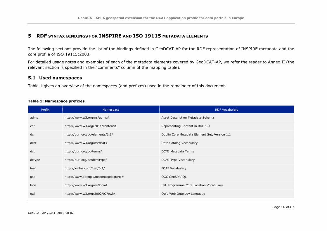
5 RDF SYNTAX BINDINGS FOR INSPIRE AND ISO 19115 METADATA ELEMENTS
The following sections provide the list of the bindings defined in GeoDCAT-AP for the RDF representation of INSPIRE metadata and the
core profile of ISO 19115:2003.
For detailed usage notes and examples of each of the metadata elements covered by GeoDCAT-AP, we refer the reader to Annex II (the
relevant section is specified in the “comments” column of the mapping table).
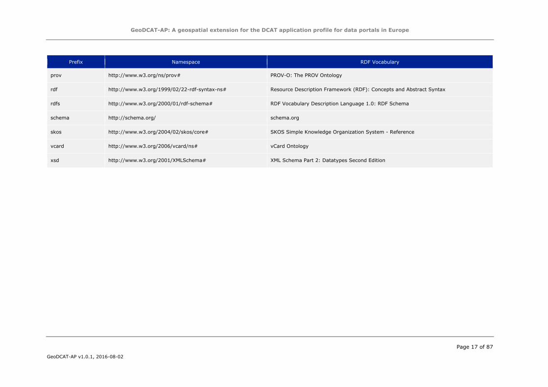
5.1 Used namespaces
Table 1 gives an overview of the namespaces (and prefixes) used in the remainder of this document.
Table 1: Namespace prefixes
Prefix Namespace RDF Vocabulary
adms http://www.w3.org/ns/adms# Asset Description Metadata Schema
cnt http://www.w3.org/2011/content# Representing Content in RDF 1.0
dc http://purl.org/dc/elements/1.1/ Dublin Core Metadata Element Set, Version 1.1
dcat http://www.w3.org/ns/dcat# Data Catalog Vocabulary
dct http://purl.org/dc/terms/ DCMI Metadata Terms
dctype http://purl.org/dc/dcmitype/ DCMI Type Vocabulary
foaf http://xmlns.com/foaf/0.1/ FOAF Vocabulary
gsp http://www.opengis.net/ont/geosparql# OGC GeoSPARQL
locn http://www.w3.org/ns/locn# ISA Programme Core Location Vocabulary
owl http://www.w3.org/2002/07/owl# OWL Web Ontology Language
GeoDCAT-AP: A geospatial extension for the DCAT application profile for data portals in Europe
Page 17 of 87
GeoDCAT-AP v1.0.1, 2016-08-02
Prefix Namespace RDF Vocabulary
prov http://www.w3.org/ns/prov# PROV-O: The PROV Ontology
rdf http://www.w3.org/1999/02/22-rdf-syntax-ns# Resource Description Framework (RDF): Concepts and Abstract Syntax
rdfs http://www.w3.org/2000/01/rdf-schema# RDF Vocabulary Description Language 1.0: RDF Schema
schema http://schema.org/ schema.org
skos http://www.w3.org/2004/02/skos/core# SKOS Simple Knowledge Organization System - Reference
vcard http://www.w3.org/2006/vcard/ns# vCard Ontology
xsd http://www.w3.org/2001/XMLSchema# XML Schema Part 2: Datatypes Second Edition
GeoDCAT-AP: A geospatial extension for the DCAT application profile for data portals in Europe
Page 18 of 87
GeoDCAT-AP v1.0.1, 2016-08-02
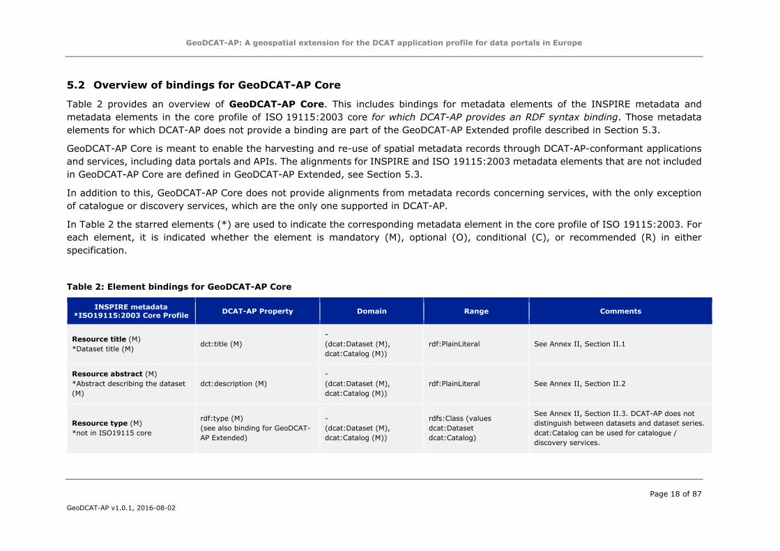
5.2 Overview of bindings for GeoDCAT-AP Core
Table 2 provides an overview of GeoDCAT-AP Core. This includes bindings for metadata elements of the INSPIRE metadata and
metadata elements in the core profile of ISO 19115:2003 core for which DCAT-AP provides an RDF syntax binding. Those metadata
elements for which DCAT-AP does not provide a binding are part of the GeoDCAT-AP Extended profile described in Section 5.3.
GeoDCAT-AP Core is meant to enable the harvesting and re-use of spatial metadata records through DCAT-AP-conformant applications
and services, including data portals and APIs. The alignments for INSPIRE and ISO 19115:2003 metadata elements that are not included
in GeoDCAT-AP Core are defined in GeoDCAT-AP Extended, see Section 5.3.
In addition to this, GeoDCAT-AP Core does not provide alignments from metadata records concerning services, with the only exception
of catalogue or discovery services, which are the only one supported in DCAT-AP.
In Table 2 the starred elements (*) are used to indicate the corresponding metadata element in the core profile of ISO 19115:2003. For
each element, it is indicated whether the element is mandatory (M), optional (O), conditional (C), or recommended (R) in either
specification.
Table 2: Element bindings for GeoDCAT-AP Core
INSPIRE metadata
*ISO19115:2003 Core Profile DCAT-AP Property Domain Range Comments
Resource title (M)
*Dataset title (M) dct:title (M)
-
(dcat:Dataset (M),
dcat:Catalog (M))
rdf:PlainLiteral See Annex II, Section II.1
Resource abstract (M)
*Abstract describing the dataset
(M)
dct:description (M)
-
(dcat:Dataset (M),
dcat:Catalog (M))
rdf:PlainLiteral See Annex II, Section II.2
Resource type (M)
*not in ISO19115 core
rdf:type (M)
(see also binding for GeoDCAT-
AP Extended)
-
(dcat:Dataset (M),
dcat:Catalog (M))
rdfs:Class (values
dcat:Dataset
dcat:Catalog)
See Annex II, Section II.3. DCAT-AP does not
distinguish between datasets and dataset series.
dcat:Catalog can be used for catalogue /
discovery services.
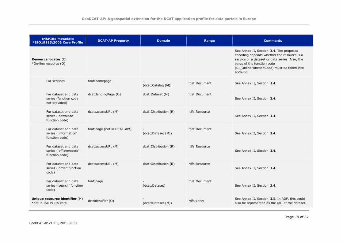
GeoDCAT-AP: A geospatial extension for the DCAT application profile for data portals in Europe
Page 19 of 87
GeoDCAT-AP v1.0.1, 2016-08-02
INSPIRE metadata
*ISO19115:2003 Core Profile DCAT-AP Property Domain Range Comments
Resource locator (C)
*On-line resource (O)
See Annex II, Section II.4. The proposed
encoding depends whether the resource is a
service or a dataset or data series. Also, the
value of the function code
(CI_OnlineFunctionCode) must be taken into
account.
For services foaf:homepage -
(dcat:Catalog (M)) foaf:Document See Annex II, Section II.4.
For dataset and data
series (function code
not provided)
dcat:landingPage (O) dcat:Dataset (M) foaf:Document
See Annex II, Section II.4.
For dataset and data
series (‘download’
function code)
dcat:accessURL (M) dcat:Distribution (R) rdfs:Resource
See Annex II, Section II.4.
For dataset and data
series (‘information’
function code)
foaf:page (not in DCAT-AP!) -
(dcat:Dataset (M))
foaf:Document
See Annex II, Section II.4.
For dataset and data
series (‘offlineAccess’
function code)
dcat:accessURL (M) dcat:Distribution (R) rdfs:Resource
See Annex II, Section II.4.
For dataset and data
series (‘order’ function
code)
dcat:accessURL (M) dcat:Distribution (R) rdfs:Resource
See Annex II, Section II.4.
For dataset and data
series (‘search’ function
code)
foaf:page -
(dcat:Dataset)
foaf:Document
See Annex II, Section II.4.
Unique resource identifier (M)
*not in ISO19115 core dct:identifier (O)
-
(dcat:Dataset (M)) rdfs:Literal
See Annex II, Section II.5. In RDF, this could
also be represented as the URI of the dataset.
GeoDCAT-AP: A geospatial extension for the DCAT application profile for data portals in Europe
Page 20 of 87
GeoDCAT-AP v1.0.1, 2016-08-02
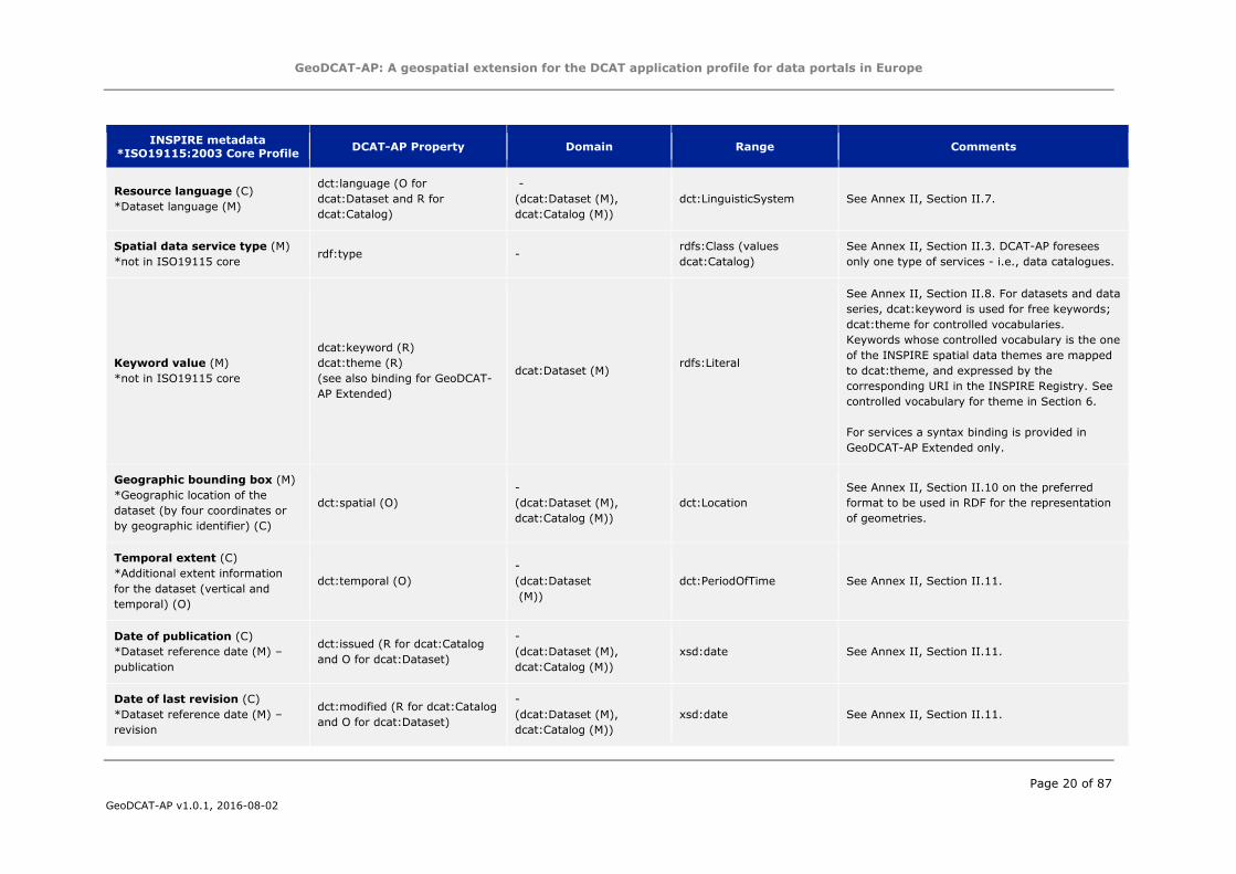
INSPIRE metadata
*ISO19115:2003 Core Profile DCAT-AP Property Domain Range Comments
Resource language (C)
*Dataset language (M)
dct:language (O for
dcat:Dataset and R for
dcat:Catalog)
-
(dcat:Dataset (M),
dcat:Catalog (M))
dct:LinguisticSystem See Annex II, Section II.7.
Spatial data service type (M)
*not in ISO19115 core rdf:type -
rdfs:Class (values
dcat:Catalog)
See Annex II, Section II.3. DCAT-AP foresees
only one type of services - i.e., data catalogues.
Keyword value (M)
*not in ISO19115 core
dcat:keyword (R)
dcat:theme (R)
(see also binding for GeoDCAT-
AP Extended)
dcat:Dataset (M) rdfs:Literal
See Annex II, Section II.8. For datasets and data
series, dcat:keyword is used for free keywords;
dcat:theme for controlled vocabularies.
Keywords whose controlled vocabulary is the one
of the INSPIRE spatial data themes are mapped
to dcat:theme, and expressed by the
corresponding URI in the INSPIRE Registry. See
controlled vocabulary for theme in Section 6.
For services a syntax binding is provided in
GeoDCAT-AP Extended only.
Geographic bounding box (M)
*Geographic location of the
dataset (by four coordinates or
by geographic identifier) (C)
dct:spatial (O)
-
(dcat:Dataset (M),
dcat:Catalog (M))
dct:Location
See Annex II, Section II.10 on the preferred
format to be used in RDF for the representation
of geometries.
Temporal extent (C)
*Additional extent information
for the dataset (vertical and
temporal) (O)
dct:temporal (O)
-
(dcat:Dataset
(M))
dct:PeriodOfTime See Annex II, Section II.11.
Date of publication (C)
*Dataset reference date (M) –
publication
dct:issued (R for dcat:Catalog
and O for dcat:Dataset)
-
(dcat:Dataset (M),
dcat:Catalog (M))
xsd:date See Annex II, Section II.11.
Date of last revision (C)
*Dataset reference date (M) –
revision
dct:modified (R for dcat:Catalog
and O for dcat:Dataset)
-
(dcat:Dataset (M),
dcat:Catalog (M))
xsd:date See Annex II, Section II.11.
GeoDCAT-AP: A geospatial extension for the DCAT application profile for data portals in Europe
Page 21 of 87
GeoDCAT-AP v1.0.1, 2016-08-02
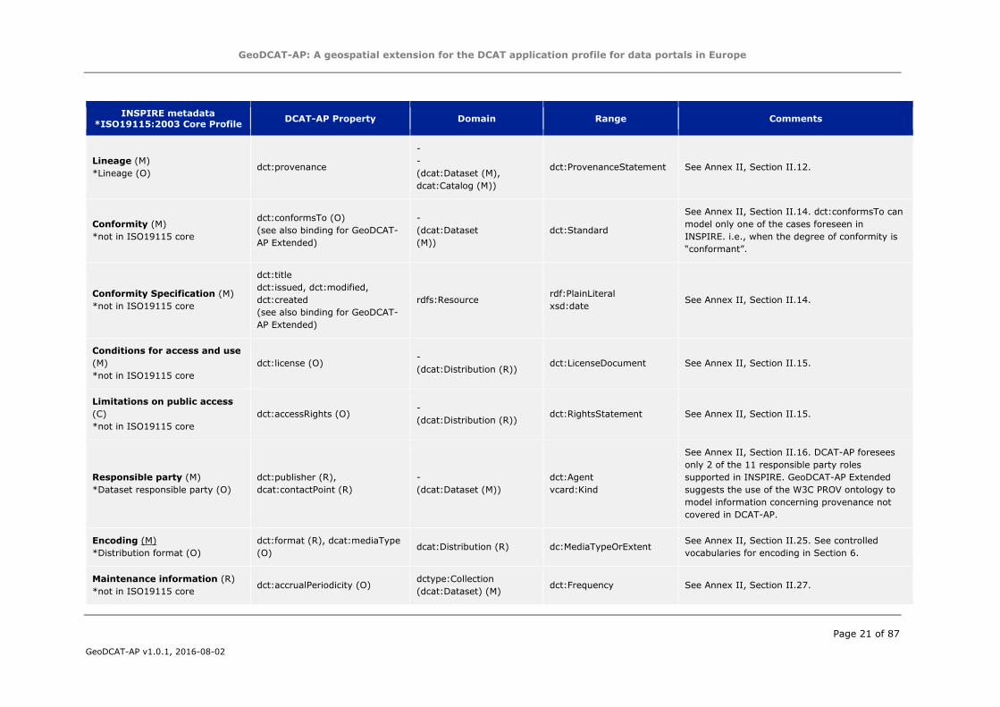
INSPIRE metadata
*ISO19115:2003 Core Profile DCAT-AP Property Domain Range Comments
Lineage (M)
*Lineage (O) dct:provenance
-
-
(dcat:Dataset (M),
dcat:Catalog (M))
dct:ProvenanceStatement See Annex II, Section II.12.
Conformity (M)
*not in ISO19115 core
dct:conformsTo (O)
(see also binding for GeoDCAT-
AP Extended)
-
(dcat:Dataset
(M))
dct:Standard
See Annex II, Section II.14. dct:conformsTo can
model only one of the cases foreseen in
INSPIRE. i.e., when the degree of conformity is
“conformant”.
Conformity Specification (M)
*not in ISO19115 core
dct:title
dct:issued, dct:modified,
dct:created
(see also binding for GeoDCAT-
AP Extended)
rdfs:Resource rdf:PlainLiteral
xsd:date See Annex II, Section II.14.
Conditions for access and use
(M)
*not in ISO19115 core
dct:license (O) -
(dcat:Distribution (R)) dct:LicenseDocument See Annex II, Section II.15.
Limitations on public access
(C)
*not in ISO19115 core
dct:accessRights (O) -
(dcat:Distribution (R)) dct:RightsStatement See Annex II, Section II.15.
Responsible party (M)
*Dataset responsible party (O)
dct:publisher (R),
dcat:contactPoint (R)
-
(dcat:Dataset (M))
dct:Agent
vcard:Kind
See Annex II, Section II.16. DCAT-AP foresees
only 2 of the 11 responsible party roles
supported in INSPIRE. GeoDCAT-AP Extended
suggests the use of the W3C PROV ontology to
model information concerning provenance not
covered in DCAT-AP.
Encoding (M)
*Distribution format (O)
dct:format (R), dcat:mediaType
(O) dcat:Distribution (R) dc:MediaTypeOrExtent
See Annex II, Section II.25. See controlled
vocabularies for encoding in Section 6.
Maintenance information (R)
*not in ISO19115 core dct:accrualPeriodicity (O)
dctype:Collection
(dcat:Dataset) (M) dct:Frequency See Annex II, Section II.27.
GeoDCAT-AP: A geospatial extension for the DCAT application profile for data portals in Europe
Page 22 of 87
GeoDCAT-AP v1.0.1, 2016-08-02
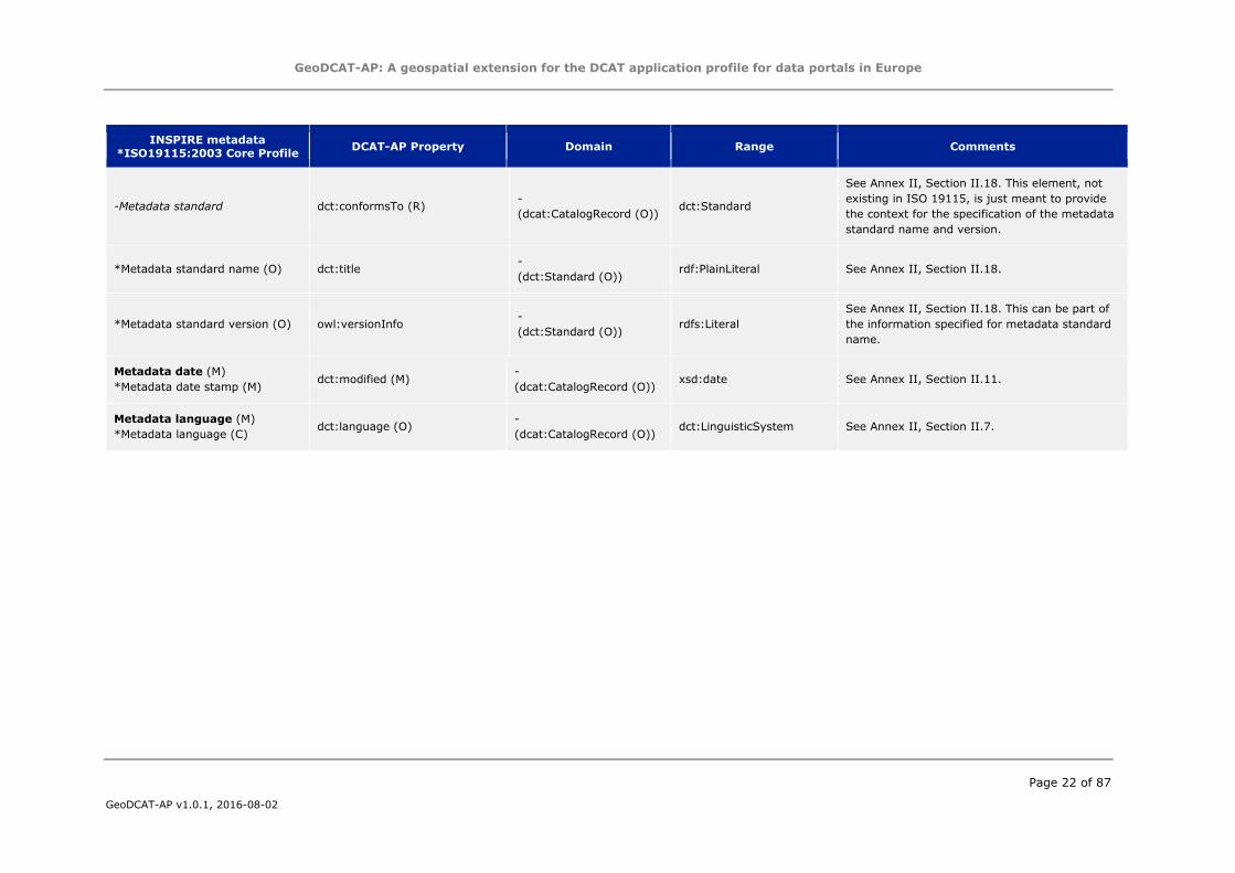
INSPIRE metadata
*ISO19115:2003 Core Profile DCAT-AP Property Domain Range Comments
-Metadata standard dct:conformsTo (R) -
(dcat:CatalogRecord (O)) dct:Standard
See Annex II, Section II.18. This element, not
existing in ISO 19115, is just meant to provide
the context for the specification of the metadata
standard name and version.
*Metadata standard name (O) dct:title -
(dct:Standard (O)) rdf:PlainLiteral See Annex II, Section II.18.
*Metadata standard version (O) owl:versionInfo -
(dct:Standard (O)) rdfs:Literal
See Annex II, Section II.18. This can be part of
the information specified for metadata standard
name.
Metadata date (M)
*Metadata date stamp (M) dct:modified (M)
-
(dcat:CatalogRecord (O)) xsd:date See Annex II, Section II.11.
Metadata language (M)
*Metadata language (C) dct:language (O)
-
(dcat:CatalogRecord (O)) dct:LinguisticSystem See Annex II, Section II.7.
GeoDCAT-AP: A geospatial extension for the DCAT application profile for data portals in Europe
Page 23 of 87
GeoDCAT-AP v1.0.1, 2016-08-02
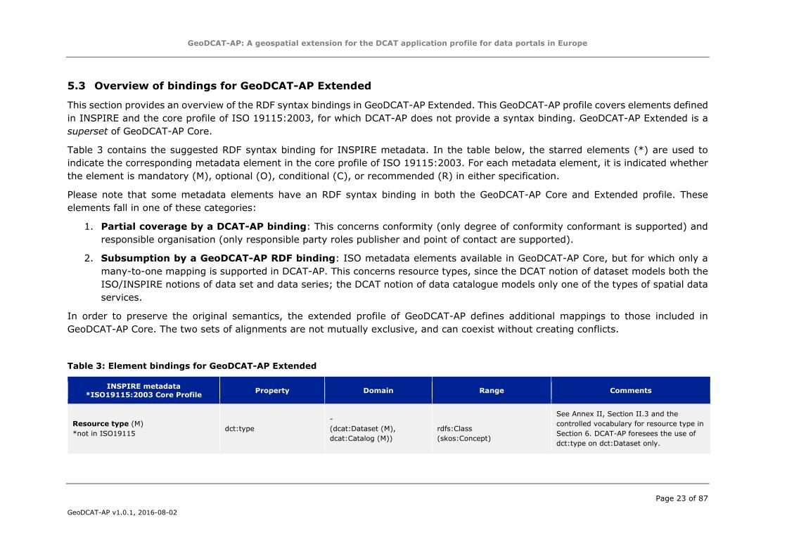
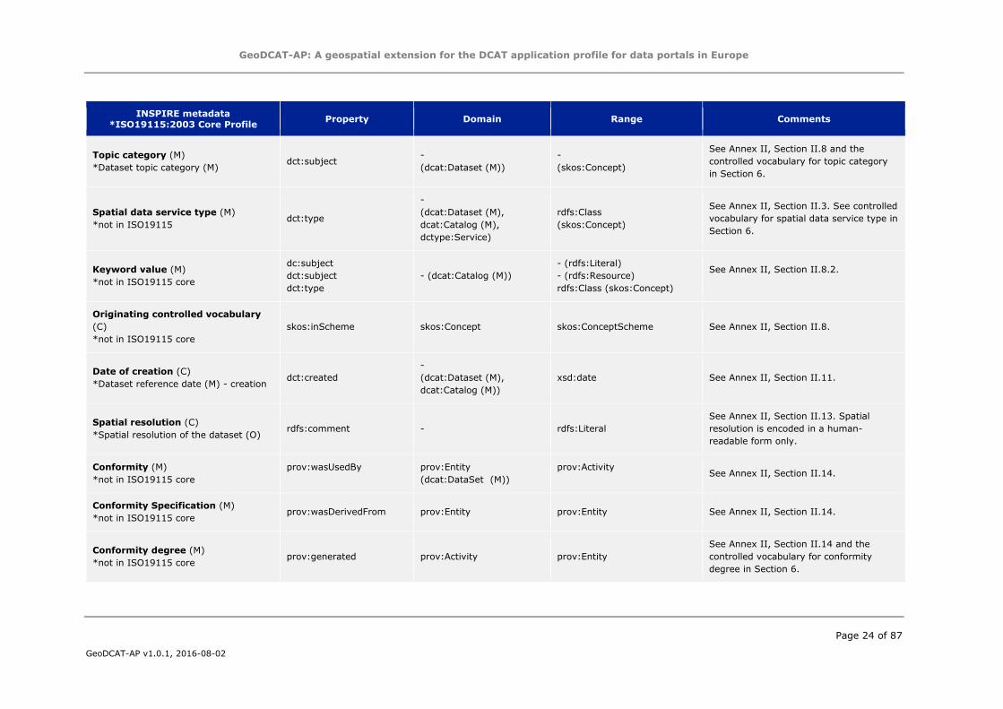
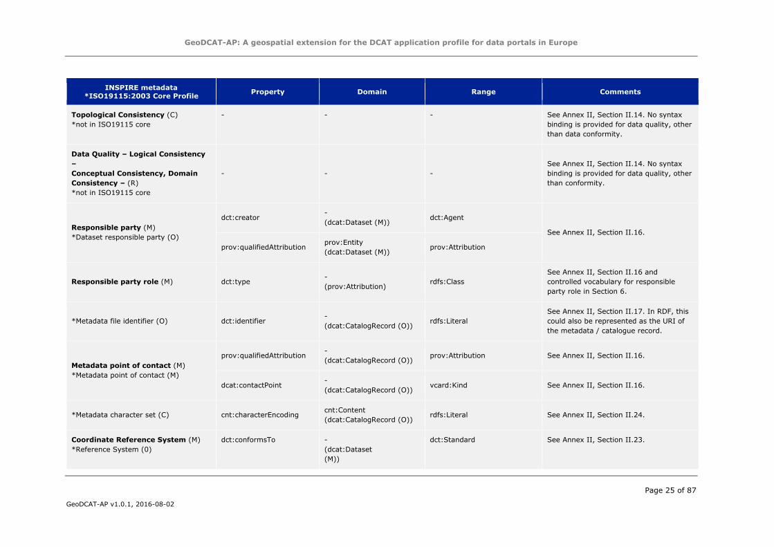
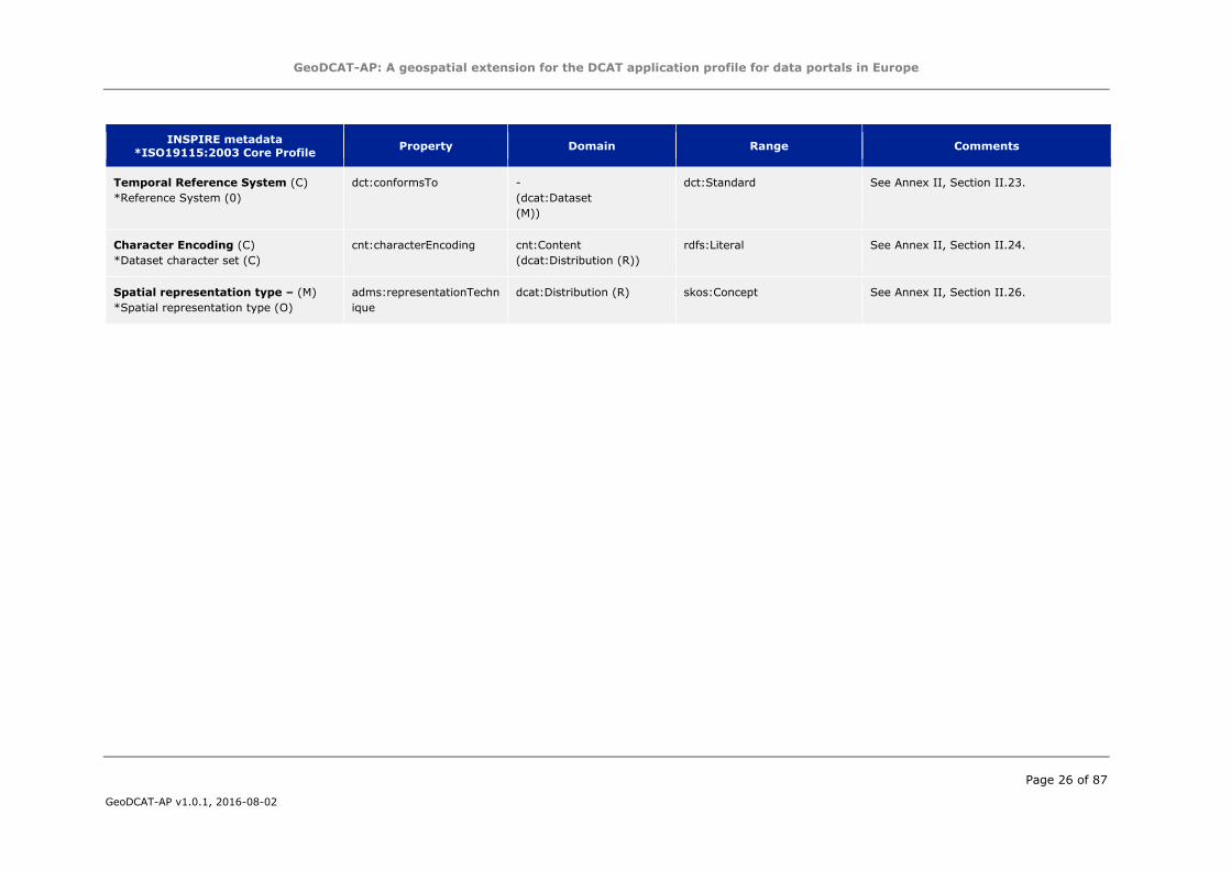
5.3 Overview of bindings for GeoDCAT-AP Extended
This section provides an overview of the RDF syntax bindings in GeoDCAT-AP Extended. This GeoDCAT-AP profile covers elements defined
in INSPIRE and the core profile of ISO 19115:2003, for which DCAT-AP does not provide a syntax binding. GeoDCAT-AP Extended is a
superset of GeoDCAT-AP Core.
Table 3 contains the suggested RDF syntax binding for INSPIRE metadata. In the table below, the starred elements (*) are used to
indicate the corresponding metadata element in the core profile of ISO 19115:2003. For each metadata element, it is indicated whether
the element is mandatory (M), optional (O), conditional (C), or recommended (R) in either specification.
Please note that some metadata elements have an RDF syntax binding in both the GeoDCAT-AP Core and Extended profile. These
elements fall in one of these categories:
1. Partial coverage by a DCAT-AP binding: This concerns conformity (only degree of conformity conformant is supported) and
responsible organisation (only responsible party roles publisher and point of contact are supported).
2. Subsumption by a GeoDCAT-AP RDF binding: ISO metadata elements available in GeoDCAT-AP Core, but for which only a
many-to-one mapping is supported in DCAT-AP. This concerns resource types, since the DCAT notion of dataset models both the
ISO/INSPIRE notions of data set and data series; the DCAT notion of data catalogue models only one of the types of spatial data
services.
In order to preserve the original semantics, the extended profile of GeoDCAT-AP defines additional mappings to those included in
GeoDCAT-AP Core. The two sets of alignments are not mutually exclusive, and can coexist without creating conflicts.
Table 3: Element bindings for GeoDCAT-AP Extended
INSPIRE metadata
*ISO19115:2003 Core Profile Property Domain Range Comments
Resource type (M)
*not in ISO19115 dct:type
-
(dcat:Dataset (M),
dcat:Catalog (M))
rdfs:Class
(skos:Concept)
See Annex II, Section II.3 and the
controlled vocabulary for resource type in
Section 6. DCAT-AP foresees the use of
dct:type on dct:Dataset only.
GeoDCAT-AP: A geospatial extension for the DCAT application profile for data portals in Europe
Page 24 of 87
GeoDCAT-AP v1.0.1, 2016-08-02
INSPIRE metadata
*ISO19115:2003 Core Profile Property Domain Range Comments
Topic category (M)
*Dataset topic category (M) dct:subject
-
(dcat:Dataset (M))
-
(skos:Concept)
See Annex II, Section II.8 and the
controlled vocabulary for topic category
in Section 6.
Spatial data service type (M)
*not in ISO19115 dct:type
-
(dcat:Dataset (M),
dcat:Catalog (M),
dctype:Service)
rdfs:Class
(skos:Concept)
See Annex II, Section II.3. See controlled
vocabulary for spatial data service type in
Section 6.
Keyword value (M)
*not in ISO19115 core
dc:subject
dct:subject
dct:type
- (dcat:Catalog (M))
- (rdfs:Literal)
- (rdfs:Resource)
rdfs:Class (skos:Concept)
See Annex II, Section II.8.2.
Originating controlled vocabulary
(C)
*not in ISO19115 core
skos:inScheme skos:Concept skos:ConceptScheme See Annex II, Section II.8.
Date of creation (C)
*Dataset reference date (M) - creation dct:created
-
(dcat:Dataset (M),
dcat:Catalog (M))
xsd:date See Annex II, Section II.11.
Spatial resolution (C)
*Spatial resolution of the dataset (O) rdfs:comment - rdfs:Literal
See Annex II, Section II.13. Spatial
resolution is encoded in a human-
readable form only.
Conformity (M)
*not in ISO19115 core
prov:wasUsedBy prov:Entity
(dcat:DataSet (M))
prov:Activity See Annex II, Section II.14.
Conformity Specification (M)
*not in ISO19115 core prov:wasDerivedFrom prov:Entity prov:Entity See Annex II, Section II.14.
Conformity degree (M)
*not in ISO19115 core prov:generated prov:Activity prov:Entity
See Annex II, Section II.14 and the
controlled vocabulary for conformity
degree in Section 6.
GeoDCAT-AP: A geospatial extension for the DCAT application profile for data portals in Europe
Page 25 of 87
GeoDCAT-AP v1.0.1, 2016-08-02
INSPIRE metadata
*ISO19115:2003 Core Profile Property Domain Range Comments
Topological Consistency (C)
*not in ISO19115 core
- - - See Annex II, Section II.14. No syntax
binding is provided for data quality, other
than data conformity.
Data Quality – Logical Consistency
–
Conceptual Consistency, Domain
Consistency – (R)
*not in ISO19115 core
- - -
See Annex II, Section II.14. No syntax
binding is provided for data quality, other
than conformity.
Responsible party (M)
*Dataset responsible party (O)
dct:creator -
(dcat:Dataset (M)) dct:Agent
See Annex II, Section II.16.
prov:qualifiedAttribution prov:Entity
(dcat:Dataset (M)) prov:Attribution
Responsible party role (M) dct:type -
(prov:Attribution) rdfs:Class
See Annex II, Section II.16 and
controlled vocabulary for responsible
party role in Section 6.
*Metadata file identifier (O) dct:identifier -
(dcat:CatalogRecord (O)) rdfs:Literal
See Annex II, Section II.17. In RDF, this
could also be represented as the URI of
the metadata / catalogue record.
Metadata point of contact (M)
*Metadata point of contact (M)
prov:qualifiedAttribution -
(dcat:CatalogRecord (O)) prov:Attribution See Annex II, Section II.16.
dcat:contactPoint -
(dcat:CatalogRecord (O)) vcard:Kind See Annex II, Section II.16.
*Metadata character set (C) cnt:characterEncoding cnt:Content
(dcat:CatalogRecord (O)) rdfs:Literal See Annex II, Section II.24.
Coordinate Reference System (M)
*Reference System (0)
dct:conformsTo -
(dcat:Dataset
(M))
dct:Standard See Annex II, Section II.23.
GeoDCAT-AP: A geospatial extension for the DCAT application profile for data portals in Europe
Page 26 of 87
GeoDCAT-AP v1.0.1, 2016-08-02
INSPIRE metadata
*ISO19115:2003 Core Profile Property Domain Range Comments
Temporal Reference System (C)
*Reference System (0)
dct:conformsTo -
(dcat:Dataset
(M))
dct:Standard See Annex II, Section II.23.
Character Encoding (C)
*Dataset character set (C)
cnt:characterEncoding cnt:Content
(dcat:Distribution (R))
rdfs:Literal See Annex II, Section II.24.
Spatial representation type – (M)
*Spatial representation type (O)
adms:representationTechn
ique
dcat:Distribution (R) skos:Concept See Annex II, Section II.26.
GeoDCAT-AP: A geospatial extension for the DCAT application profile for data portals in Europe
Page 27 of 87
GeoDCAT-AP v1.0.1, 2016-08-02
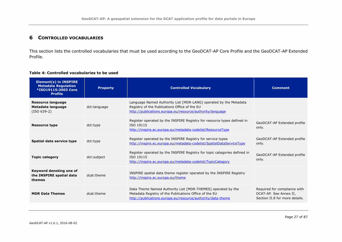
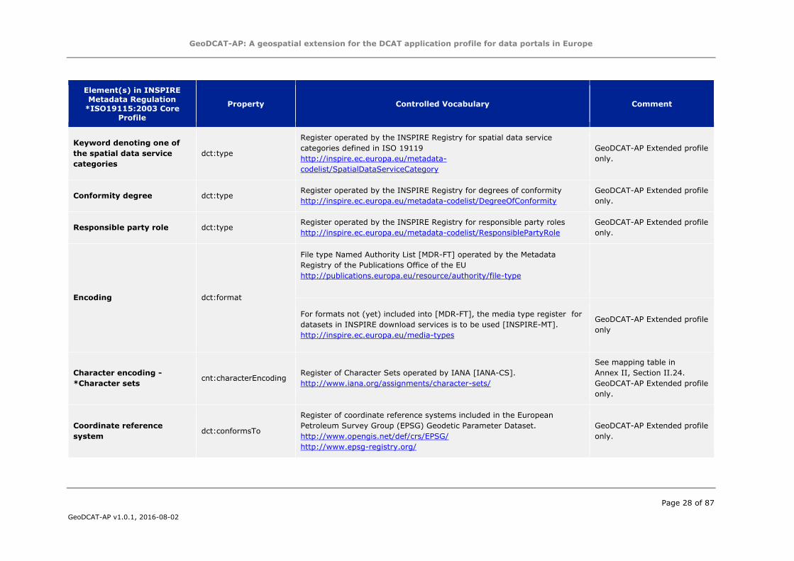
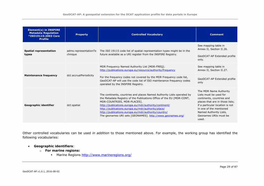
6 CONTROLLED VOCABULARIES
This section lists the controlled vocabularies that must be used according to the GeoDCAT-AP Core Profile and the GeoDCAT-AP Extended
Profile.
Table 4: Controlled vocabularies to be used
Element(s) in INSPIRE
Metadata Regulation
*ISO19115:2003 Core
Profile
Property Controlled Vocabulary Comment
Resource language
Metadata language
(ISO 639-2)
dct:language
Language Named Authority List [MDR-LANG] operated by the Metadata
Registry of the Publications Office of the EU
http://publications.europa.eu/resource/authority/language
Resource type dct:type
Register operated by the INSPIRE Registry for resource types defined in
ISO 19115
http://inspire.ec.europa.eu/metadata-codelist/ResourceType
GeoDCAT-AP Extended profile
only.
Spatial data service type dct:type Register operated by the INSPIRE Registry for service types
http://inspire.ec.europa.eu/metadata-codelist/SpatialDataServiceType
GeoDCAT-AP Extended profile
only.
Topic category dct:subject
Register operated by the INSPIRE Registry for topic categories defined in
ISO 19115
http://inspire.ec.europa.eu/metadata-codelist/TopicCategory
GeoDCAT-AP Extended profile
only.
Keyword denoting one of
the INSPIRE spatial data
themes
dcat:theme INSPIRE spatial data theme register operated by the INSPIRE Registry
http://inspire.ec.europa.eu/theme
MDR Data Themes dcat:theme
Data Theme Named Authority List [MDR-THEMES] operated by the
Metadata Registry of the Publications Office of the EU
http://publications.europa.eu/resource/authority/data-theme
Required for compliance with
DCAT-AP. See Annex II,
Section II.8 for more details.
GeoDCAT-AP: A geospatial extension for the DCAT application profile for data portals in Europe
Page 28 of 87
GeoDCAT-AP v1.0.1, 2016-08-02
Element(s) in INSPIRE
Metadata Regulation
*ISO19115:2003 Core
Profile
Property Controlled Vocabulary Comment
Keyword denoting one of
the spatial data service
categories
dct:type
Register operated by the INSPIRE Registry for spatial data service
categories defined in ISO 19119
http://inspire.ec.europa.eu/metadata-
codelist/SpatialDataServiceCategory
GeoDCAT-AP Extended profile
only.
Conformity degree dct:type Register operated by the INSPIRE Registry for degrees of conformity
http://inspire.ec.europa.eu/metadata-codelist/DegreeOfConformity
GeoDCAT-AP Extended profile
only.
Responsible party role dct:type Register operated by the INSPIRE Registry for responsible party roles
http://inspire.ec.europa.eu/metadata-codelist/ResponsiblePartyRole
GeoDCAT-AP Extended profile
only.
Encoding dct:format
File type Named Authority List [MDR-FT] operated by the Metadata
Registry of the Publications Office of the EU
http://publications.europa.eu/resource/authority/file-type
For formats not (yet) included into [MDR-FT], the media type register for
datasets in INSPIRE download services is to be used [INSPIRE-MT].
http://inspire.ec.europa.eu/media-types
GeoDCAT-AP Extended profile
only
Character encoding -
*Character sets cnt:characterEncoding
Register of Character Sets operated by IANA [IANA-CS].
http://www.iana.org/assignments/character-sets/
See mapping table in
Annex II, Section II.24.
GeoDCAT-AP Extended profile
only.
Coordinate reference
system dct:conformsTo
Register of coordinate reference systems included in the European
Petroleum Survey Group (EPSG) Geodetic Parameter Dataset.
http://www.opengis.net/def/crs/EPSG/
http://www.epsg-registry.org/
GeoDCAT-AP Extended profile
only.
GeoDCAT-AP: A geospatial extension for the DCAT application profile for data portals in Europe
Page 29 of 87
GeoDCAT-AP v1.0.1, 2016-08-02
Element(s) in INSPIRE
Metadata Regulation
*ISO19115:2003 Core
Profile
Property Controlled Vocabulary Comment
Spatial representation
types
adms:representationTe
chnique
The ISO 19115 code list of spatial representation types might be in the
future available as a URI register from the INSPIRE Registry.
See mapping table in
Annex II, Section II.26.
GeoDCAT-AP Extended profile
only.
Maintenance frequency dct:accrualPeriodicity
MDR Frequency Named Authority List [MDR-FREQ].
http://publications.europa.eu/resource/authority/frequency
See mapping table in
Annex II, Section II.27.
For the frequency codes not covered by the MDR Frequency code list,
GeoDCAT-AP will use the code list of ISO maintenance frequency codes
operated by the INSPIRE Registry.
GeoDCAT-AP Extended profile
only
Geographic identifier dct:spatial
The continents, countries and places Named Authority Lists operated by
the Metadata Registry of the Publications Office of the EU [MDR-CONT,
MDR-COUNTRIES, MDR-PLACES].
http://publications.europa.eu/mdr/authority/continent/
http://publications.europa.eu/mdr/authority/place/
http://publications.europa.eu/mdr/authority/country/
The geonames URI sets [GEONAMES]. http://www.geonames.org/
The MDR Name Authority
Lists must be used for
continents, countries and
places that are in those lists;
if a particular location is not
in one of the mentioned
Named Authority Lists,
Geonames URIs must be
used.
Other controlled vocabularies can be used in addition to those mentioned above. For example, the working group has identified the
following vocabularies:
Geographic identifiers:
o For marine regions:
Marine Regions http://www.marineregions.org/
GeoDCAT-AP: A geospatial extension for the DCAT application profile for data portals in Europe
Page 30 of 87
GeoDCAT-AP v1.0.1, 2016-08-02
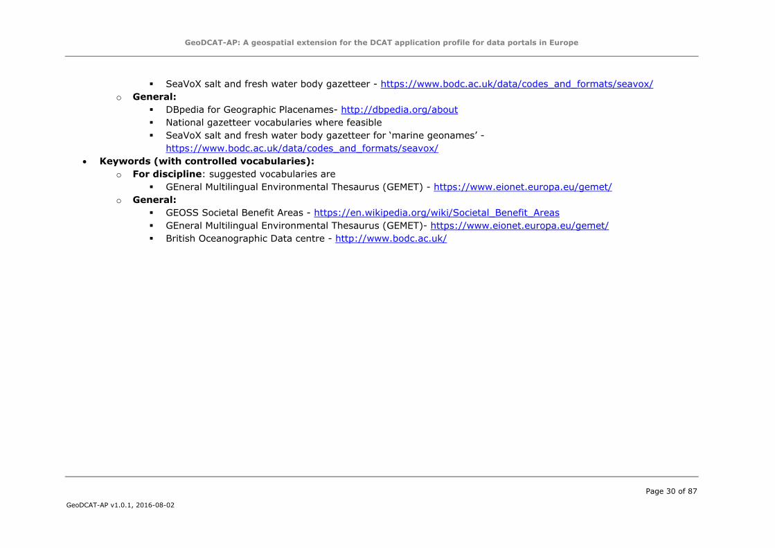
SeaVoX salt and fresh water body gazetteer - https://www.bodc.ac.uk/data/codes_and_formats/seavox/
o General:
DBpedia for Geographic Placenames- http://dbpedia.org/about
National gazetteer vocabularies where feasible
SeaVoX salt and fresh water body gazetteer for ‘marine geonames’ -
https://www.bodc.ac.uk/data/codes_and_formats/seavox/
Keywords (with controlled vocabularies):
o For discipline: suggested vocabularies are
GEneral Multilingual Environmental Thesaurus (GEMET) - https://www.eionet.europa.eu/gemet/
o General:
GEOSS Societal Benefit Areas - https://en.wikipedia.org/wiki/Societal_Benefit_Areas
GEneral Multilingual Environmental Thesaurus (GEMET)- https://www.eionet.europa.eu/gemet/
British Oceanographic Data centre - http://www.bodc.ac.uk/
GeoDCAT-AP: A geospatial extension for the DCAT application profile for data portals in Europe
Page 31 of 87
GeoDCAT-AP v1.0.1, 2016-08-02
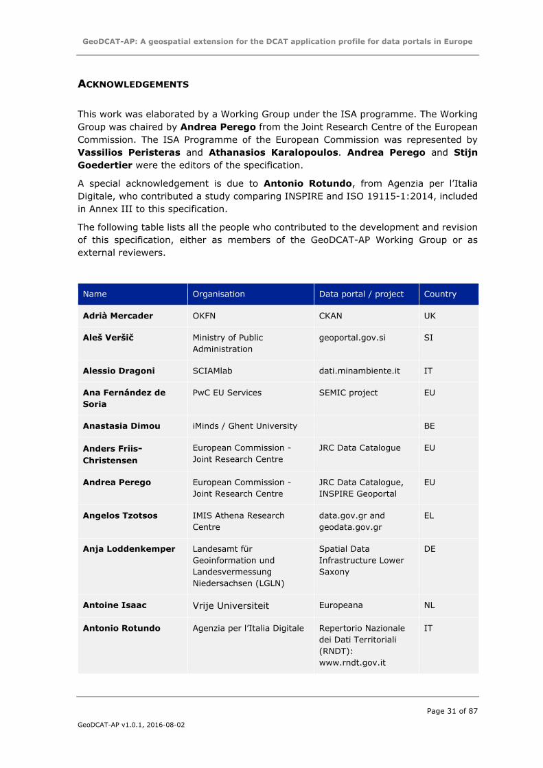
ACKNOWLEDGEMENTS
This work was elaborated by a Working Group under the ISA programme. The Working
Group was chaired by Andrea Perego from the Joint Research Centre of the European
Commission. The ISA Programme of the European Commission was represented by
Vassilios Peristeras and Athanasios Karalopoulos. Andrea Perego and Stijn
Goedertier were the editors of the specification.
A special acknowledgement is due to Antonio Rotundo, from Agenzia per l’Italia
Digitale, who contributed a study comparing INSPIRE and ISO 19115-1:2014, included
in Annex III to this specification.
The following table lists all the people who contributed to the development and revision
of this specification, either as members of the GeoDCAT-AP Working Group or as
external reviewers.
Name Organisation Data portal / project Country
Adrià Mercader OKFN CKAN UK
Aleš Veršič Ministry of Public
Administration
geoportal.gov.si SI
Alessio Dragoni SCIAMlab dati.minambiente.it IT
Ana Fernández de
Soria
PwC EU Services SEMIC project EU
Anastasia Dimou iMinds / Ghent University BE
Anders Friis-
Christensen
European Commission -
Joint Research Centre
JRC Data Catalogue EU
Andrea Perego European Commission -
Joint Research Centre
JRC Data Catalogue,
INSPIRE Geoportal
EU
Angelos Tzotsos IMIS Athena Research
Centre
data.gov.gr and
geodata.gov.gr
EL
Anja Loddenkemper Landesamt für
Geoinformation und
Landesvermessung
Niedersachsen (LGLN)
Spatial Data
Infrastructure Lower
Saxony
DE
Antoine Isaac Vrije Universiteit Europeana NL
Antonio Rotundo Agenzia per l’Italia Digitale Repertorio Nazionale
dei Dati Territoriali
(RNDT):
www.rndt.gov.it
IT
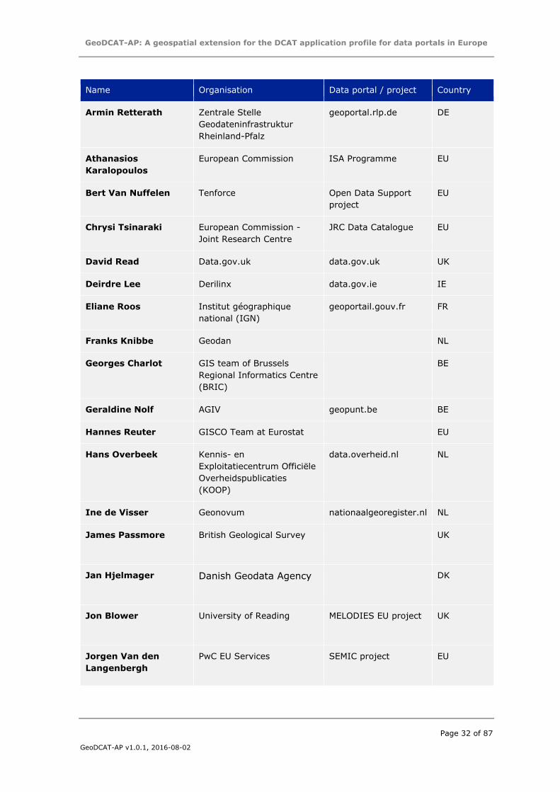
GeoDCAT-AP: A geospatial extension for the DCAT application profile for data portals in Europe
Page 32 of 87
GeoDCAT-AP v1.0.1, 2016-08-02
Name Organisation Data portal / project Country
Armin Retterath Zentrale Stelle
Geodateninfrastruktur
Rheinland-Pfalz
geoportal.rlp.de DE
Athanasios
Karalopoulos
European Commission ISA Programme EU
Bert Van Nuffelen Tenforce Open Data Support
project
EU
Chrysi Tsinaraki European Commission -
Joint Research Centre
JRC Data Catalogue EU
David Read Data.gov.uk data.gov.uk UK
Deirdre Lee Derilinx data.gov.ie IE
Eliane Roos Institut géographique
national (IGN)
geoportail.gouv.fr FR
Franks Knibbe Geodan NL
Georges Charlot GIS team of Brussels
Regional Informatics Centre
(BRIC)
BE
Geraldine Nolf AGIV geopunt.be BE
Hannes Reuter GISCO Team at Eurostat EU
Hans Overbeek Kennis- en
Exploitatiecentrum Officiële
Overheidspublicaties
(KOOP)
data.overheid.nl NL
Ine de Visser Geonovum nationaalgeoregister.nl NL
James Passmore British Geological Survey UK
Jan Hjelmager Danish Geodata Agency DK
Jon Blower University of Reading MELODIES EU project UK
Jorgen Van den
Langenbergh
PwC EU Services SEMIC project EU
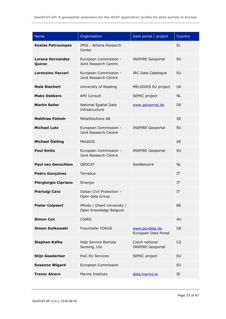
GeoDCAT-AP: A geospatial extension for the DCAT application profile for data portals in Europe
Page 33 of 87
GeoDCAT-AP v1.0.1, 2016-08-02
Name Organisation Data portal / project Country
Kostas Patroumpas IMIS - Athena Research
Center
EL
Lorena Hernandez
Quiroz
European Commission -
Joint Research Centre
INSPIRE Geoportal EU
Lorenzino Vaccari European Commission -
Joint Research Centre
JRC Data Catalogue EU
Maik Riechert University of Reading MELODIES EU project UK
Makx Dekkers AMI Consult SEMIC project NL
Martin Seiler National Spatial Data
Infrastructure
www.geoportal.de DE
Matthias Palmér MetaSolutions AB SE
Michael Lutz European Commission -
Joint Research Centre
INSPIRE Geoportal EU
Michael Östling MetaGIS SE
Paul Smits European Commission -
Joint Research Centre
INSPIRE Geoportal EU
Paul van Genuchten GEOCAT GeoNetwork NL
Pedro Gonçalves Terradue IT
Piergiorgio Cipriano Sinergis IT
Pierluigi Cara Italian Civil Protection –
Open data Group
IT
Pieter Colpaert iMinds / Ghent University /
Open Knowledge Belgium
BE
Simon Cox CSIRO AU
Simon Dutkowski Fraunhofer FOKUS www.govdata.de,
European Data Portal
DE
Stephan Kafka Help Service Remote
Sensing, Ltd.
Czech national
INSPIRE Geoportal
CZ
Stijn Goedertier PwC EU Services SEMIC project EU
Susanne Wigard European Commission EU
Trevor Alcorn Marine Institute data.marine.ie IE
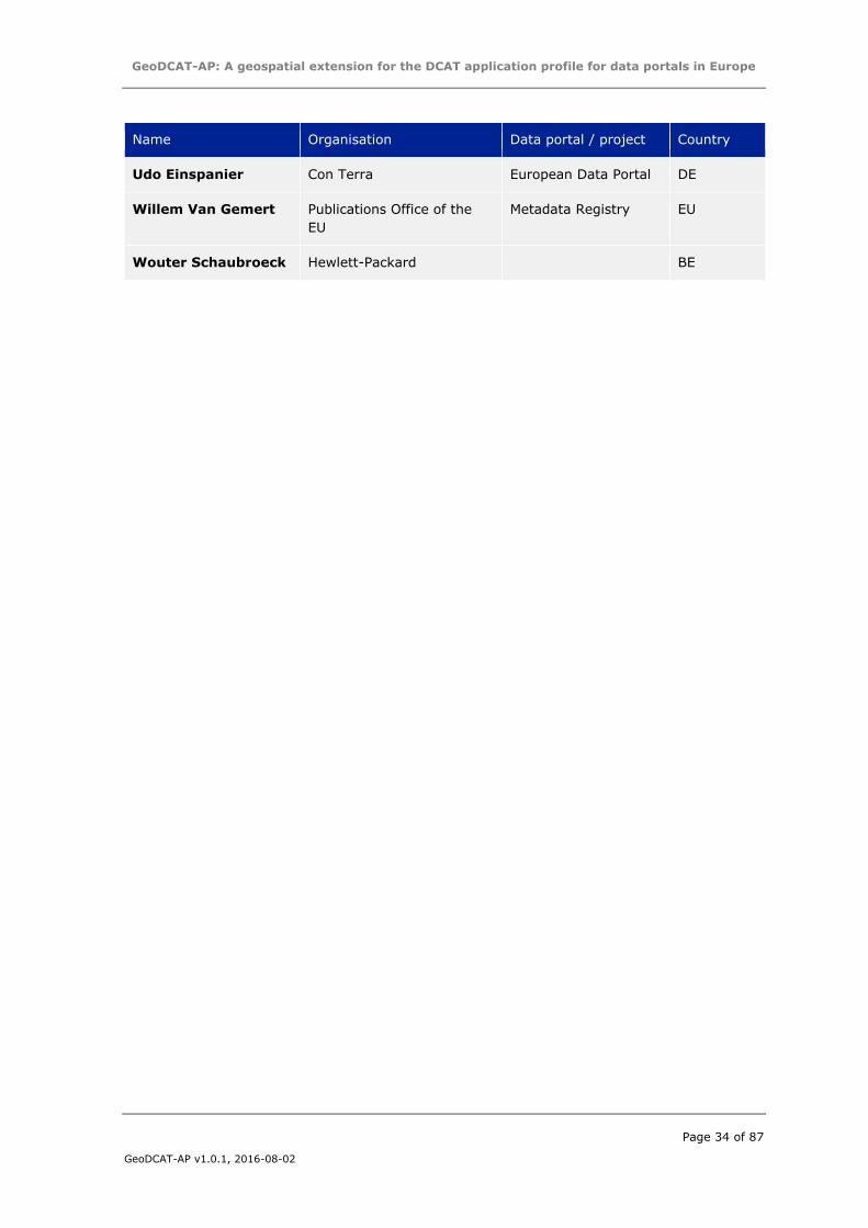
GeoDCAT-AP: A geospatial extension for the DCAT application profile for data portals in Europe
Page 34 of 87
GeoDCAT-AP v1.0.1, 2016-08-02
Name Organisation Data portal / project Country
Udo Einspanier Con Terra European Data Portal DE
Willem Van Gemert Publications Office of the
EU
Metadata Registry EU
Wouter Schaubroeck Hewlett-Packard BE
GeoDCAT-AP: A geospatial extension for the DCAT application profile for data portals in Europe
Page 35 of 87
GeoDCAT-AP v1.0.1, 2016-08-02
REFERENCES
[BCP47] IETF, “IEFT BCP 47 Tags for Identifying Languages,” 2009. [Online]. Available: http://tools.ietf.org/html/bcp47
[CLD-FREQ] DCMI, “Dublin Core Collection Description Frequency Vocabulary,” 2007. [Online]. Available: http://dublincore.org/groups/collections/frequency/
[CNT] W3C, “Representing Content in RDF - W3C Content Vocabulary,” [Online].
Available: http://www.w3.org/TR/Content-in-RDF10/
[CSW] Open Geospatial Consortium, “Catalogue Services Specification 2.0.2, OGC 07-045, ISO Metadata Application Profile for CSW 2.0,” 2007. [Online]. Available: http://www.opengeospatial.org/standards/cat
[DCAT] W3C, “Data Catalog Vocabulary (DCAT),” 2014. [Online]. Available: http://www.w3.org/TR/vocab-dcat/
[DCAT-AP] European Commission, ISA Programme, “DCAT Application Profile for data
portals in Europe,” 2015. [Online]. Available: https://joinup.ec.europa.eu/node/63567
[DCTERMS] DCMI, “DCMI Metadata Terms,” 2012. [Online]. Available:
http://dublincore.org/documents/2012/06/14/dcmi-terms/
[DCWIKI] DCMI, “User Guide / Publishing Metadata,” [Online]. Available: http://wiki.dublincore.org/index.php/User_Guide/Publishing_Metadata
[EARL] W3C, “W3C Evaluation and Report Language (EARL),” 2011. [Online].
Available: http://www.w3.org/TR/EARL10-Schema/
[GEODCAT-XSLT] A. Perego, “XSLT for converting ISO 19139 metadata into DCAT-AP,” 2015. [Online]. Available:
https://webgate.ec.europa.eu/CITnet/stash/projects/ODCKAN/repos/iso-19139-to-dcat-ap/
[GEOHASH] Wikipedia, “Geohash,” [Online]. Available:
http://en.wikipedia.org/wiki/Geohash
[GEOHASH-36] Wikipedia, “Geohash-36,” [Online]. Available: http://en.wikipedia.org/wiki/Geohash-36
[GEOJSON] H. Butler, M. Daly, A. Doyle, S. Gillies, T. Schaub and C. Schmidt, “The
GeoJSON Format Specification,” 2008. [Online]. Available: http://geojson.org/geojson-spec.html
[GEONAMES] geonames.org, “Geonames.org,” [Online]. Available:
http://www.geonames.org/
[GEOSPARQL] Open Geospatial Consortium, “GeoSPARQL - A Geographic Query Language for RDF Data,” 2012. [Online]. Available:
http://www.opengeospatial.org/standards/geosparql
[GML] Open Geospatial Consortium, “Geography Markup Language,” [Online]. Available: http://www.opengeospatial.org/standards/gml
GeoDCAT-AP: A geospatial extension for the DCAT application profile for data portals in Europe
Page 36 of 87
GeoDCAT-AP v1.0.1, 2016-08-02
[IANA-CS] IANA, “Character Sets,” [Online]. Available: http://www.iana.org/assignments/character-sets/character-sets.xhtml
[IANA-MT] IANA, “Media Types Register,” [Online]. Available: http://www.iana.org/assignments/media-types/media-types.xhtml
[INSPIRE-D&S-REG] European Commission, “Commission Regulation (EU) No 1089/2010 of 23 November 2010 implementing Directive 2007/2/EC of the European Parliament and of the Council as regards interoperability of spatial data
sets and services,” 2010. [Online]. Available: http://eur-lex.europa.eu/eli/reg/com/2010/1089 .
[INSPIRE-DC] European Commission, “State of progress in the development of guidelines to express elements of the INSPIRE metadata implementing rules using
ISO 15836 (Dublin core),” [Online]. Available: http://inspire.ec.europa.eu/reports/ImplementingRules/metadata/MD_IR_and_DC_state%20of%20progress.pdf
[INSPIRE-DCAT] INSPIRE Maintenance and Implementation Group, “Alignment of INSPIRE metadata with DCAT-AP,” 2014. [Online]. Available: https://ies-svn.jrc.ec.europa.eu/projects/metadata/wiki/Alignment_of_INSPIRE_meta
data_with_DCAT-AP
[INSPIRE-DIR] European Parliament, “DIRECTIVE 2007/2/EC OF THE EUROPEAN PARLIAMENT AND OF THE COUNCIL of 14 March 2007 establishing an Infrastructure for Spatial Information in the European Community
(INSPIRE),” 2007. [Online]. Available: http://eur-lex.europa.eu/LexUriServ/LexUriServ.do?uri=OJ:L:2007:108:0001:0014:en:PDF
[INSPIRE-DS-TG] European Commission, “Technical Guidance for the implementation of INSPIRE Discovery Services. Version 3.1,” 2011. [Online]. Available: http://inspire.jrc.ec.europa.eu/documents/Network_Services/TechnicalGui
dance_DiscoveryServices_v3.1.pdf
[INSPIRE-MD-REG] European Commission, “Commission Regulation (EC) No 1205/2008 of 3 December 2008 implementing Directive 2007/2/EC of the European Parliament and of the Council as regards metadata,” 2008. [Online].
Available: http://eur-lex.europa.eu/eli/reg/com/2008/1205
[INSPIRE-MD-TG] European Commission, “INSPIRE Metadata Implementing Rules: Technical Guidelines based on EN ISO 19115 and EN ISO 19119,” 2013. [Online].
Available: http://inspire.ec.europa.eu/index.cfm/pageid/101
[INSPIRE-MT] European Commission, “INSPIRE Media Type Register,” [Online]. Available: http://inspire.ec.europa.eu/media-types/
[ISO19115] ISO (International Organization for Standardization), “ISO 19115:2003 Geographic information -- Metadata,” 2003. [Online]. Available: http://www.iso.org/iso/catalogue_detail?csnumber=26020
[ISO19115-1] ISO (International Organization for Standardization), “ISO 19115-1:2014 -
- Geographic information -- Metadata -- Part 1: Fundamentals,” 2014. [Online]. Available:
http://www.iso.org/iso/iso_catalogue/catalogue_tc/catalogue_detail.htm?c
snumber=53798
[ISO19119] ISO (International Organization for Standardization), “ISO 19119:2005 -- Geographic information -- Services,” 2005. [Online]. Available:
GeoDCAT-AP: A geospatial extension for the DCAT application profile for data portals in Europe
Page 37 of 87
GeoDCAT-AP v1.0.1, 2016-08-02
http://www.iso.org/iso/home/store/catalogue_tc/catalogue_detail.htm?csnumber=39890
[ISO19125-1] ISO (International Organization for Standardization), “ISO 19125-1:2004
Geographic information -- Simple feature access -- Part 1: Common
architecture,” 2004. [Online]. Available: http://www.iso.org/iso/home/store/catalogue_tc/catalogue_detail.htm?csnumber=40114
[ISO19139] ISO (International Organization for Standardization), “ISO/TS 19139:2007 - Geographic information -- Metadata -- XML schema implementation,” 2007. [Online]. Available: http://www.iso.org/iso/catalogue_detail.htm?csnumber=32557
[ISO639-2] ISO (International Organization for Standardization), “ISO 639-2:1998 Codes for the representation of names of languages -- Part 2: Alpha-3 code,” 1998. [Online]. Available:
http://www.iso.org/iso/catalogue_detail?csnumber=4767
[KML] Open Geospatial Consortium, “Keyhole Markup Language (KML),” [Online]. Available: http://www.opengeospatial.org/standards/kml
[LAT-LONG] W3C, “WGS84 Geo Positioning: an RDF vocabulary,” 2009. [Online]. Available: http://www.w3.org/2003/01/geo/wgs84_pos#
[LOCN] European Commission, ISA Programme, “ISA Programme Location Core Vocabulary,” 2015. [Online]. Available: http://www.w3.org/ns/locn#
[MDR-CONT] Publications Office of the EU, “Named Authority List: Continents,” [Online].
Available: http://publications.europa.eu/mdr/authority/continent/
[MDR-COUNTRIES] Publications Office of the EU, “Named Authority List: Countries,” [Online].
Available: http://publications.europa.eu/mdr/authority/country/
[MDR-FREQ] Publications Office of the EU, “Named Authority List: Frequencies,” [Online]. Available:
http://publications.europa.eu/mdr/authority/frequency/
[MDR-FT] Publications Office of the EU, “Named Authority List: File Types,” [Online]. Available: http://publications.europa.eu/mdr/authority/file-type/
[MDR-LANG] Publications Office of the EU, “Named Authority List: Languages,” [Online].
Available: http://publications.europa.eu/mdr/authority/language/
[MDR-PLACES] Publications Office of the EU, “Named Authority List: Places,” [Online]. Available: http://publications.europa.eu/mdr/authority/place/
[MDR-THEMES] Publications Office of the EU, “Named Authority List: Data Themes,” [Online]. Available: http://publications.europa.eu/mdr/authority/data-theme/
[NEOGEO] GeoVocab.org, “NeoGeo Vocabulary Specification - Madrid Edition,” 2012. [Online]. Available: http://geovocab.org/doc/neogeo/
[PROV] W3C, “PROV-O: The PROV Ontology,” 2013. [Online]. Available: http://www.w3.org/TR/prov-o/
[RFC4288] IETF, “RFC 4288 – Media Type Specifications and Registration Procedures,” 2005. [Online]. Available: https://tools.ietf.org/html/rfc4288
GeoDCAT-AP: A geospatial extension for the DCAT application profile for data portals in Europe
Page 38 of 87
GeoDCAT-AP v1.0.1, 2016-08-02
[RFC5870] IETF, “RFC 5870 - A Uniform Resource Identifier for Geographic Locations ('geo' URI),” 2010. [Online]. Available: https://tools.ietf.org/html/rfc5870
[SCHEMA] “Schema.org,” [Online]. Available: http://schema.org
[VCARD] W3C, “vCard Ontology for describing persons and organisations,” 2013.
[Online]. Available: http://www.w3.org/TR/vcard-rdf/
[XML] W3C, “Extensible Markup Language (XML) 1.0 (Fifth Edition),” [Online]. Available: http://www.w3.org/TR/2008/REC-xml-20081126/
GeoDCAT-AP: A geospatial extension for the DCAT application profile for data portals in Europe
Page 39 of 87
GeoDCAT-AP v1.0.1, 2016-08-02
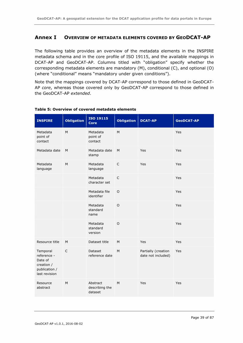
Annex I OVERVIEW OF METADATA ELEMENTS COVERED BY GEODCAT-AP
The following table provides an overview of the metadata elements in the INSPIRE
metadata schema and in the core profile of ISO 19115, and the available mappings in
DCAT-AP and GeoDCAT-AP. Columns titled with “obligation” specify whether the
corresponding metadata elements are mandatory (M), conditional (C), and optional (O)
(where “conditional” means “mandatory under given conditions”).
Note that the mappings covered by DCAT-AP correspond to those defined in GeoDCAT-
AP core, whereas those covered only by GeoDCAT-AP correspond to those defined in
the GeoDCAT-AP extended.
Table 5: Overview of covered metadata elements
INSPIRE Obligation ISO 19115
Core Obligation DCAT-AP GeoDCAT-AP
Metadata
point of
contact
M Metadata
point of
contact
M Yes
Metadata date M Metadata date
stamp
M Yes Yes
Metadata
language
M Metadata
language
C Yes Yes
Metadata
character set
C Yes
Metadata file
identifier
O Yes
Metadata
standard
name
O Yes
Metadata
standard
version
O Yes
Resource title M Dataset title M Yes Yes
Temporal
reference -
Date of
creation /
publication /
last revision
C Dataset
reference date
M Partially (creation
date not included)
Yes
Resource
abstract
M Abstract
describing the
dataset
M Yes Yes
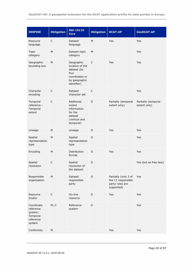
GeoDCAT-AP: A geospatial extension for the DCAT application profile for data portals in Europe
Page 40 of 87
GeoDCAT-AP v1.0.1, 2016-08-02
INSPIRE Obligation ISO 19115
Core Obligation DCAT-AP GeoDCAT-AP
Resource
language
C Dataset
language
M Yes Yes
Topic
category
M Dataset topic
category
M Yes
Geographic
bounding box
M Geographic
location of the
dataset (by
four
coordinates or
by geographic
identifier)
C Yes Yes
Character
encoding
C Dataset
character set
C Yes
Temporal
reference -
Temporal
extent
C Additional
extent
information
for the
dataset
(vertical and
temporal)
O Partially (temporal
extent only)
Partially (temporal
extent only)
Lineage M Lineage O Yes Yes
Spatial
representation
type
M Spatial
representation
type
O Yes
Encoding M Distribution
format
O Yes Yes
Spatial
resolution
C Spatial
resolution of
the dataset
O Yes (but as free text)
Responsible
organisation
M Dataset
responsible
party
O Partially (only 3 of
the 11 responsible
party roles are
supported)
Yes
Resource
locator
C On-line
resource
O Yes Yes
Coordinate
reference
system;
Temporal
reference
system
M; C Reference
system
O Yes
Conformity M Yes Yes
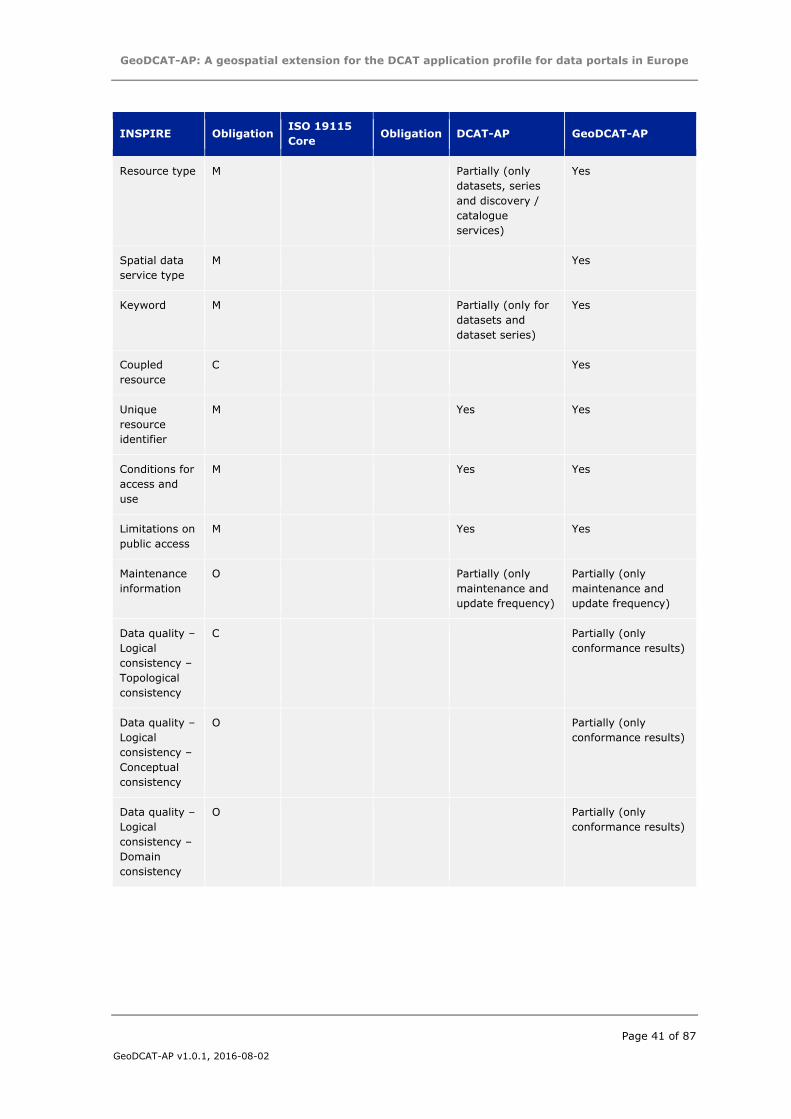
GeoDCAT-AP: A geospatial extension for the DCAT application profile for data portals in Europe
Page 41 of 87
GeoDCAT-AP v1.0.1, 2016-08-02
INSPIRE Obligation ISO 19115
Core Obligation DCAT-AP GeoDCAT-AP
Resource type M Partially (only
datasets, series
and discovery /
catalogue
services)
Yes
Spatial data
service type
M Yes
Keyword M Partially (only for
datasets and
dataset series)
Yes
Coupled
resource
C Yes
Unique
resource
identifier
M Yes Yes
Conditions for
access and
use
M Yes Yes
Limitations on
public access
M Yes Yes
Maintenance
information
O Partially (only
maintenance and
update frequency)
Partially (only
maintenance and
update frequency)
Data quality –
Logical
consistency –
Topological
consistency
C Partially (only
conformance results)
Data quality –
Logical
consistency –
Conceptual
consistency
O Partially (only
conformance results)
Data quality –
Logical
consistency –
Domain
consistency
O Partially (only
conformance results)
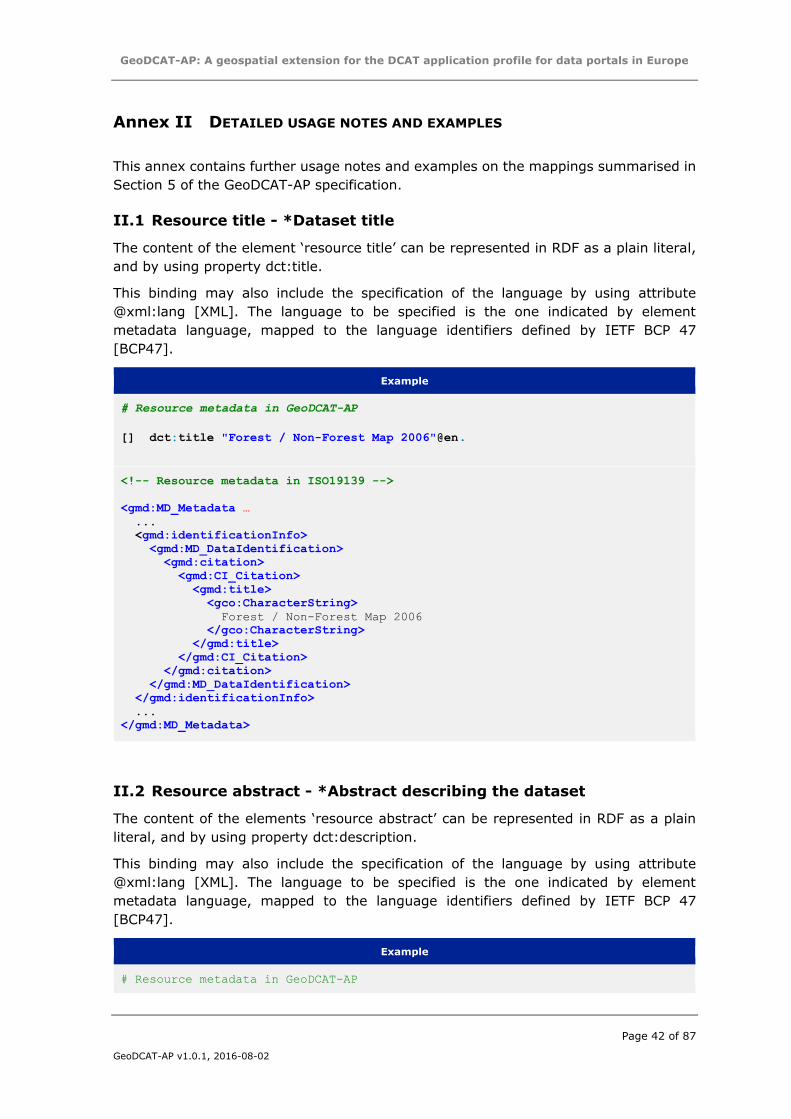
GeoDCAT-AP: A geospatial extension for the DCAT application profile for data portals in Europe
Page 42 of 87
GeoDCAT-AP v1.0.1, 2016-08-02
Annex II DETAILED USAGE NOTES AND EXAMPLES
This annex contains further usage notes and examples on the mappings summarised in
Section 5 of the GeoDCAT-AP specification.
II.1 Resource title - *Dataset title
The content of the element ‘resource title’ can be represented in RDF as a plain literal,
and by using property dct:title.
This binding may also include the specification of the language by using attribute
@xml:lang [XML]. The language to be specified is the one indicated by element
metadata language, mapped to the language identifiers defined by IETF BCP 47
[BCP47].
Example
# Resource metadata in GeoDCAT-AP
[] dct:title "Forest / Non-Forest Map 2006"@en.
<!-- Resource metadata in ISO19139 -->
<gmd:MD_Metadata …
...
<gmd:identificationInfo>
<gmd:MD_DataIdentification>
<gmd:citation>
<gmd:CI_Citation>
<gmd:title>
<gco:CharacterString>
Forest / Non-Forest Map 2006
</gco:CharacterString>
</gmd:title>
</gmd:CI_Citation>
</gmd:citation>
</gmd:MD_DataIdentification>
</gmd:identificationInfo>
...
</gmd:MD_Metadata>
II.2 Resource abstract - *Abstract describing the dataset
The content of the elements ‘resource abstract’ can be represented in RDF as a plain
literal, and by using property dct:description.
This binding may also include the specification of the language by using attribute
@xml:lang [XML]. The language to be specified is the one indicated by element
metadata language, mapped to the language identifiers defined by IETF BCP 47
[BCP47].
Example
# Resource metadata in GeoDCAT-AP
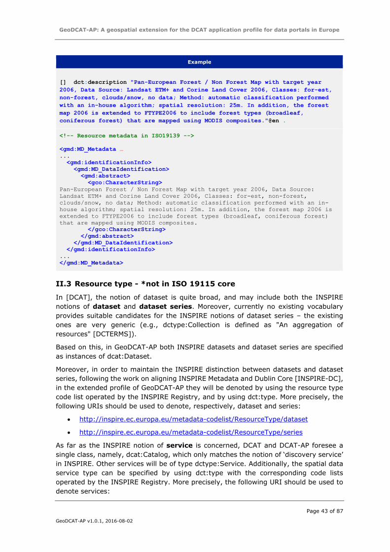
GeoDCAT-AP: A geospatial extension for the DCAT application profile for data portals in Europe
Page 43 of 87
GeoDCAT-AP v1.0.1, 2016-08-02
Example
[] dct:description "Pan-European Forest / Non Forest Map with target year
2006, Data Source: Landsat ETM+ and Corine Land Cover 2006, Classes: for-est,
non-forest, clouds/snow, no data; Method: automatic classification performed
with an in-house algorithm; spatial resolution: 25m. In addition, the forest
map 2006 is extended to FTYPE2006 to include forest types (broadleaf,
coniferous forest) that are mapped using MODIS composites."@en .
<!-- Resource metadata in ISO19139 -->
<gmd:MD_Metadata …
...
<gmd:identificationInfo>
<gmd:MD_DataIdentification>
<gmd:abstract>
<gco:CharacterString>
Pan-European Forest / Non Forest Map with target year 2006, Data Source:
Landsat ETM+ and Corine Land Cover 2006, Classes: for-est, non-forest,
clouds/snow, no data; Method: automatic classification performed with an in-
house algorithm; spatial resolution: 25m. In addition, the forest map 2006 is
extended to FTYPE2006 to include forest types (broadleaf, coniferous forest)
that are mapped using MODIS composites.
</gco:CharacterString>
</gmd:abstract>
</gmd:MD_DataIdentification>
</gmd:identificationInfo>
...
</gmd:MD_Metadata>
II.3 Resource type - *not in ISO 19115 core
In [DCAT], the notion of dataset is quite broad, and may include both the INSPIRE
notions of dataset and dataset series. Moreover, currently no existing vocabulary
provides suitable candidates for the INSPIRE notions of dataset series – the existing
ones are very generic (e.g., dctype:Collection is defined as "An aggregation of
resources" [DCTERMS]).
Based on this, in GeoDCAT-AP both INSPIRE datasets and dataset series are specified
as instances of dcat:Dataset.
Moreover, in order to maintain the INSPIRE distinction between datasets and dataset
series, following the work on aligning INSPIRE Metadata and Dublin Core [INSPIRE-DC],
in the extended profile of GeoDCAT-AP they will be denoted by using the resource type
code list operated by the INSPIRE Registry, and by using dct:type. More precisely, the
following URIs should be used to denote, respectively, dataset and series:
http://inspire.ec.europa.eu/metadata-codelist/ResourceType/dataset
http://inspire.ec.europa.eu/metadata-codelist/ResourceType/series
As far as the INSPIRE notion of service is concerned, DCAT and DCAT-AP foresee a
single class, namely, dcat:Catalog, which only matches the notion of ‘discovery service’
in INSPIRE. Other services will be of type dctype:Service. Additionally, the spatial data
service type can be specified by using dct:type with the corresponding code lists
operated by the INSPIRE Registry. More precisely, the following URI should be used to
denote services:
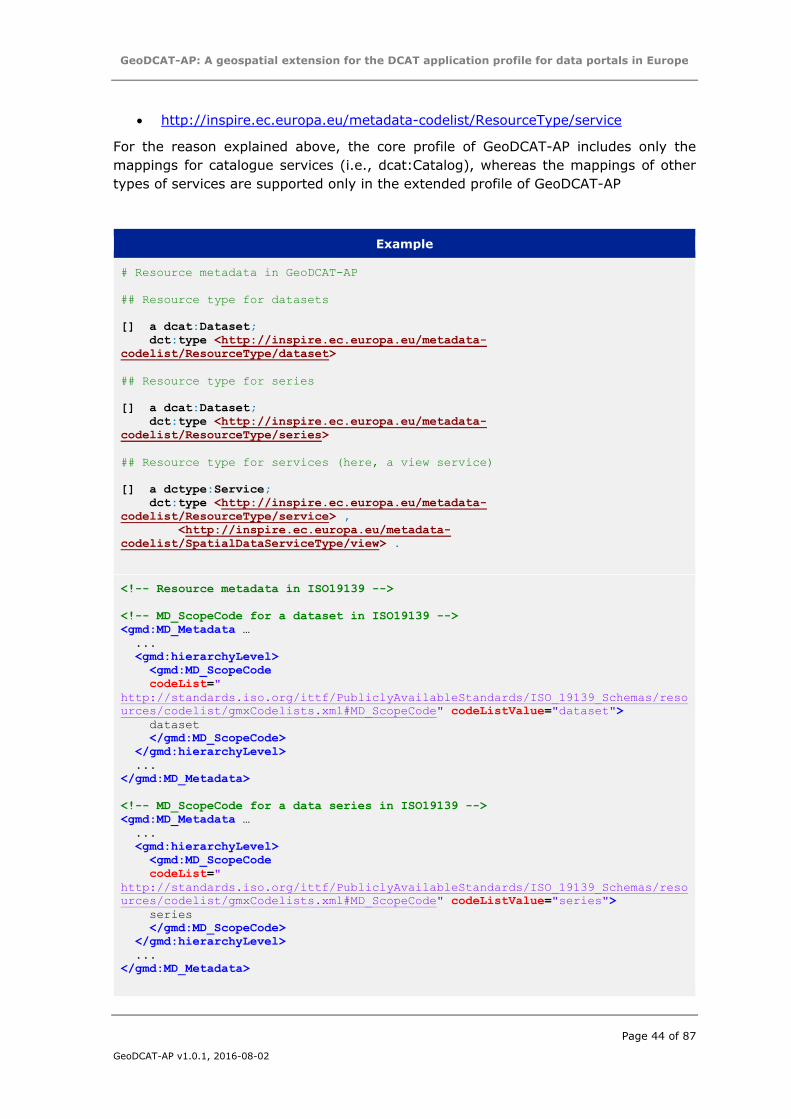
GeoDCAT-AP: A geospatial extension for the DCAT application profile for data portals in Europe
Page 44 of 87
GeoDCAT-AP v1.0.1, 2016-08-02
http://inspire.ec.europa.eu/metadata-codelist/ResourceType/service
For the reason explained above, the core profile of GeoDCAT-AP includes only the
mappings for catalogue services (i.e., dcat:Catalog), whereas the mappings of other
types of services are supported only in the extended profile of GeoDCAT-AP
Example
# Resource metadata in GeoDCAT-AP
## Resource type for datasets
[] a dcat:Dataset;
dct:type <http://inspire.ec.europa.eu/metadata-
codelist/ResourceType/dataset>
## Resource type for series
[] a dcat:Dataset;
dct:type <http://inspire.ec.europa.eu/metadata-
codelist/ResourceType/series>
## Resource type for services (here, a view service)
[] a dctype:Service;
dct:type <http://inspire.ec.europa.eu/metadata-
codelist/ResourceType/service> ,
<http://inspire.ec.europa.eu/metadata-
codelist/SpatialDataServiceType/view> .
<!-- Resource metadata in ISO19139 -->
<!-- MD_ScopeCode for a dataset in ISO19139 -->
<gmd:MD_Metadata …
...
<gmd:hierarchyLevel>
<gmd:MD_ScopeCode
codeList="
http://standards.iso.org/ittf/PubliclyAvailableStandards/ISO_19139_Schemas/reso
urces/codelist/gmxCodelists.xml#MD_ScopeCode" codeListValue="dataset">
dataset
</gmd:MD_ScopeCode>
</gmd:hierarchyLevel>
...
</gmd:MD_Metadata>
<!-- MD_ScopeCode for a data series in ISO19139 -->
<gmd:MD_Metadata …
...
<gmd:hierarchyLevel>
<gmd:MD_ScopeCode
codeList="
http://standards.iso.org/ittf/PubliclyAvailableStandards/ISO_19139_Schemas/reso
urces/codelist/gmxCodelists.xml#MD_ScopeCode" codeListValue="series">
series
</gmd:MD_ScopeCode>
</gmd:hierarchyLevel>
...
</gmd:MD_Metadata>
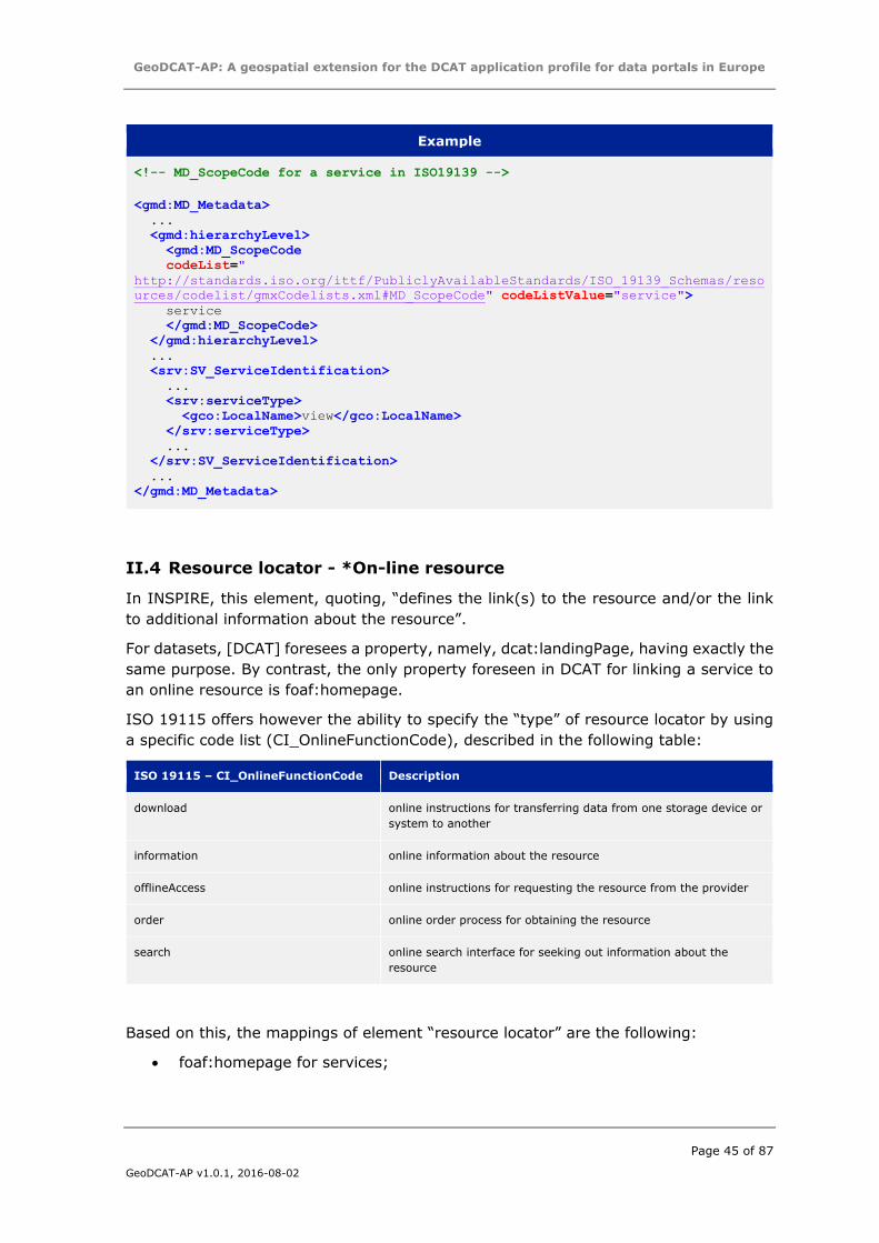
GeoDCAT-AP: A geospatial extension for the DCAT application profile for data portals in Europe
Page 45 of 87
GeoDCAT-AP v1.0.1, 2016-08-02
Example
<!-- MD_ScopeCode for a service in ISO19139 -->
<gmd:MD_Metadata>
...
<gmd:hierarchyLevel>
<gmd:MD_ScopeCode
codeList="
http://standards.iso.org/ittf/PubliclyAvailableStandards/ISO_19139_Schemas/reso
urces/codelist/gmxCodelists.xml#MD_ScopeCode" codeListValue="service">
service
</gmd:MD_ScopeCode>
</gmd:hierarchyLevel>
...
<srv:SV_ServiceIdentification>
...
<srv:serviceType>
<gco:LocalName>view</gco:LocalName>
</srv:serviceType>
...
</srv:SV_ServiceIdentification>
...
</gmd:MD_Metadata>
II.4 Resource locator - *On-line resource
In INSPIRE, this element, quoting, “defines the link(s) to the resource and/or the link
to additional information about the resource”.
For datasets, [DCAT] foresees a property, namely, dcat:landingPage, having exactly the
same purpose. By contrast, the only property foreseen in DCAT for linking a service to
an online resource is foaf:homepage.
ISO 19115 offers however the ability to specify the “type” of resource locator by using
a specific code list (CI_OnlineFunctionCode), described in the following table:
ISO 19115 – CI_OnlineFunctionCode Description
download online instructions for transferring data from one storage device or
system to another
information online information about the resource
offlineAccess online instructions for requesting the resource from the provider
order online order process for obtaining the resource
search online search interface for seeking out information about the
resource
Based on this, the mappings of element “resource locator” are the following:
foaf:homepage for services;
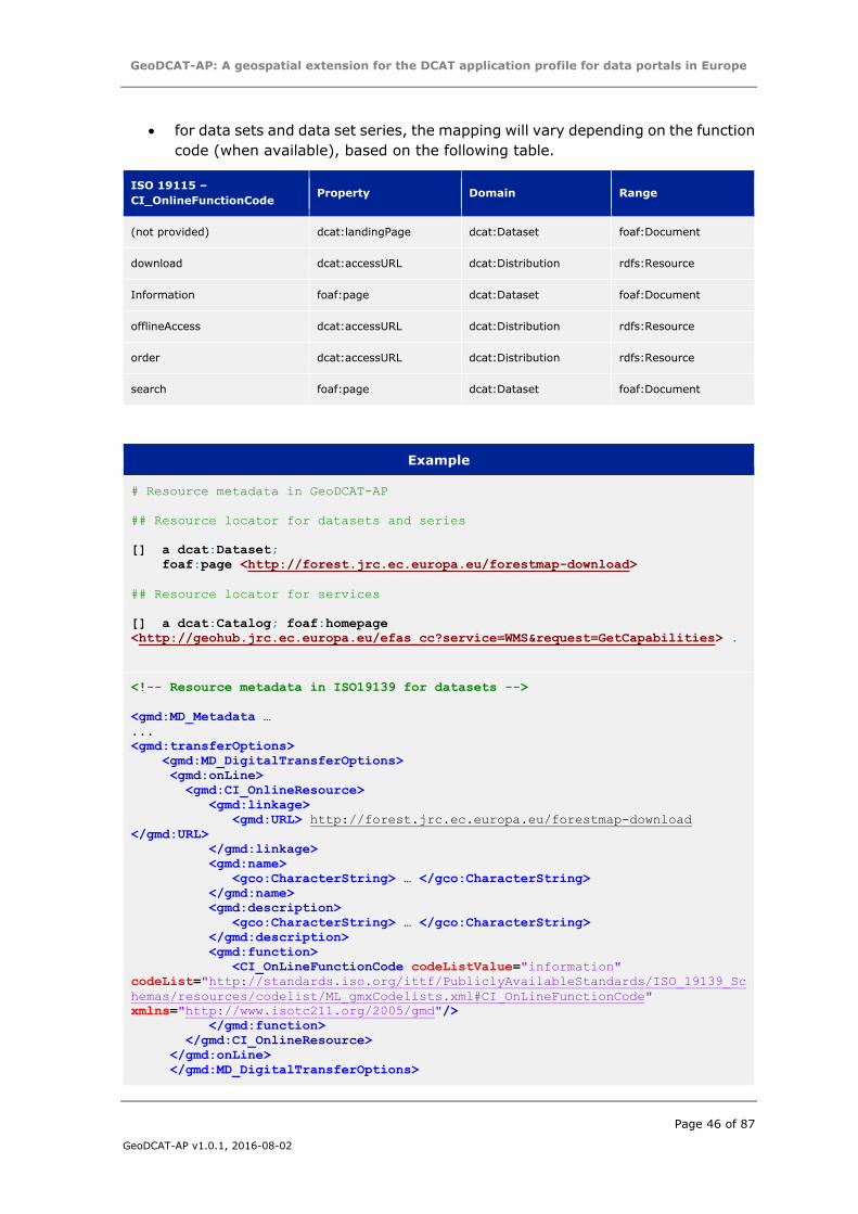
GeoDCAT-AP: A geospatial extension for the DCAT application profile for data portals in Europe
Page 46 of 87
GeoDCAT-AP v1.0.1, 2016-08-02
for data sets and data set series, the mapping will vary depending on the function
code (when available), based on the following table.
ISO 19115 –
CI_OnlineFunctionCode Property Domain Range
(not provided) dcat:landingPage dcat:Dataset foaf:Document
download dcat:accessURL dcat:Distribution rdfs:Resource
Information foaf:page dcat:Dataset foaf:Document
offlineAccess dcat:accessURL dcat:Distribution rdfs:Resource
order dcat:accessURL dcat:Distribution rdfs:Resource
search foaf:page dcat:Dataset foaf:Document
Example
# Resource metadata in GeoDCAT-AP
## Resource locator for datasets and series
[] a dcat:Dataset;
foaf:page <http://forest.jrc.ec.europa.eu/forestmap-download>
## Resource locator for services
[] a dcat:Catalog; foaf:homepage
<http://geohub.jrc.ec.europa.eu/efas_cc?service=WMS&request=GetCapabilities> .
<!-- Resource metadata in ISO19139 for datasets -->
<gmd:MD_Metadata …
...
<gmd:transferOptions>
<gmd:MD_DigitalTransferOptions>
<gmd:onLine>
<gmd:CI_OnlineResource>
<gmd:linkage>
<gmd:URL> http://forest.jrc.ec.europa.eu/forestmap-download
</gmd:URL>
</gmd:linkage>
<gmd:name>
<gco:CharacterString> … </gco:CharacterString>
</gmd:name>
<gmd:description>
<gco:CharacterString> … </gco:CharacterString>
</gmd:description>
<gmd:function>
<CI_OnLineFunctionCode codeListValue="information"
codeList="http://standards.iso.org/ittf/PubliclyAvailableStandards/ISO_19139_Sc
hemas/resources/codelist/ML_gmxCodelists.xml#CI_OnLineFunctionCode"
xmlns="http://www.isotc211.org/2005/gmd"/>
</gmd:function>
</gmd:CI_OnlineResource>
</gmd:onLine>
</gmd:MD_DigitalTransferOptions>
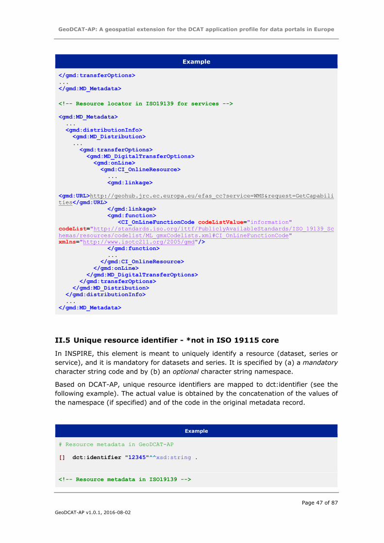
GeoDCAT-AP: A geospatial extension for the DCAT application profile for data portals in Europe
Page 47 of 87
GeoDCAT-AP v1.0.1, 2016-08-02
Example
</gmd:transferOptions>
...
</gmd:MD_Metadata>
<!-- Resource locator in ISO19139 for services -->
<gmd:MD_Metadata>
...
<gmd:distributionInfo>
<gmd:MD_Distribution>
...
<gmd:transferOptions>
<gmd:MD_DigitalTransferOptions>
<gmd:onLine>
<gmd:CI_OnlineResource>
...
<gmd:linkage>
<gmd:URL>http://geohub.jrc.ec.europa.eu/efas_cc?service=WMS&request=GetCapabili
ties</gmd:URL>
</gmd:linkage>
<gmd:function>
<CI_OnLineFunctionCode codeListValue="information"
codeList="http://standards.iso.org/ittf/PubliclyAvailableStandards/ISO_19139_Sc
hemas/resources/codelist/ML_gmxCodelists.xml#CI_OnLineFunctionCode"
xmlns="http://www.isotc211.org/2005/gmd"/>
</gmd:function>
...
</gmd:CI_OnlineResource>
</gmd:onLine>
</gmd:MD_DigitalTransferOptions>
</gmd:transferOptions>
</gmd:MD_Distribution>
</gmd:distributionInfo>
...
</gmd:MD_Metadata>
II.5 Unique resource identifier - *not in ISO 19115 core
In INSPIRE, this element is meant to uniquely identify a resource (dataset, series or
service), and it is mandatory for datasets and series. It is specified by (a) a mandatory
character string code and by (b) an optional character string namespace.
Based on DCAT-AP, unique resource identifiers are mapped to dct:identifier (see the
following example). The actual value is obtained by the concatenation of the values of
the namespace (if specified) and of the code in the original metadata record.
Example
# Resource metadata in GeoDCAT-AP
[] dct:identifier "12345"^^xsd:string .
<!-- Resource metadata in ISO19139 -->
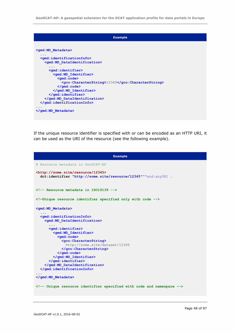
GeoDCAT-AP: A geospatial extension for the DCAT application profile for data portals in Europe
Page 48 of 87
GeoDCAT-AP v1.0.1, 2016-08-02
Example
<gmd:MD_Metadata>
...
<gmd:identificationInfo>
<gmd:MD_DataIdentification>
...
<gmd:identifier>
<gmd:MD_Identifier>
<gmd:code>
<gco:CharacterString>12345</gco:CharacterString>
</gmd:code>
</gmd:MD_Identifier>
</gmd:identifier>
</gmd:MD_DataIdentification>
</gmd:identificationInfo>
...
</gmd:MD_Metadata>
If the unique resource identifier is specified with or can be encoded as an HTTP URI, it
can be used as the URI of the resource (see the following example).
Example
# Resource metadata in GeoDCAT-AP
<http://some.site/resource/12345>
dct:identifier "http://some.site/resource/12345"^^xsd:anyURI .
<!-- Resource metadata in ISO19139 -->
<!—Unique resource identifier specified only with code -->
<gmd:MD_Metadata>
...
<gmd:identificationInfo>
<gmd:MD_DataIdentification>
...
<gmd:identifier>
<gmd:MD_Identifier>
<gmd:code>
<gco:CharacterString>
http://some.site/dataset/12345
</gco:CharacterString>
</gmd:code>
</gmd:MD_Identifier>
</gmd:identifier>
</gmd:MD_DataIdentification>
</gmd:identificationInfo>
...
</gmd:MD_Metadata>
<!-- Unique resource identifier specified with code and namespace -->
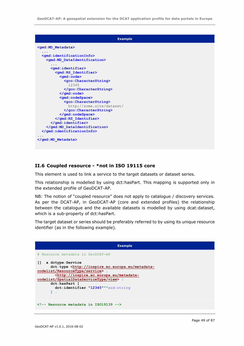
GeoDCAT-AP: A geospatial extension for the DCAT application profile for data portals in Europe
Page 49 of 87
GeoDCAT-AP v1.0.1, 2016-08-02
Example
<gmd:MD_Metadata>
...
<gmd:identificationInfo>
<gmd:MD_DataIdentification>
...
<gmd:identifier>
<gmd:RS_Identifier>
<gmd:code>
<gco:CharacterString>
12345
</gco:CharacterString>
</gmd:code>
<gmd:codeSpace>
<gco:CharacterString>
http://some.site/dataset/
</gco:CharacterString>
</gmd:codeSpace>
</gmd:RS_Identifier>
</gmd:identifier>
</gmd:MD_DataIdentification>
</gmd:identificationInfo>
...
</gmd:MD_Metadata>
II.6 Coupled resource - *not in ISO 19115 core
This element is used to link a service to the target datasets or dataset series.
This relationship is modelled by using dct:hasPart. This mapping is supported only in
the extended profile of GeoDCAT-AP.
NB: The notion of “coupled resource” does not apply to catalogue / discovery services.
As per the DCAT-AP, in GeoDCAT-AP (core and extended profiles) the relationship
between the catalogue and the available datasets is modelled by using dcat:dataset,
which is a sub-property of dct:hasPart.
The target dataset or series should be preferably referred to by using its unique resource
identifier (as in the following example).
Example
# Resource metadata in GeoDCAT-AP
[] a dctype:Service
dct:type <http://inspire.ec.europa.eu/metadata-
codelist/ResourceType/service> ,
<http://inspire.ec.europa.eu/metadata-
codelist/SpatialDataServiceType/view> ;
dct:hasPart [
dct:identifier "12345"^^xsd:string
] .
<!-- Resource metadata in ISO19139 -->
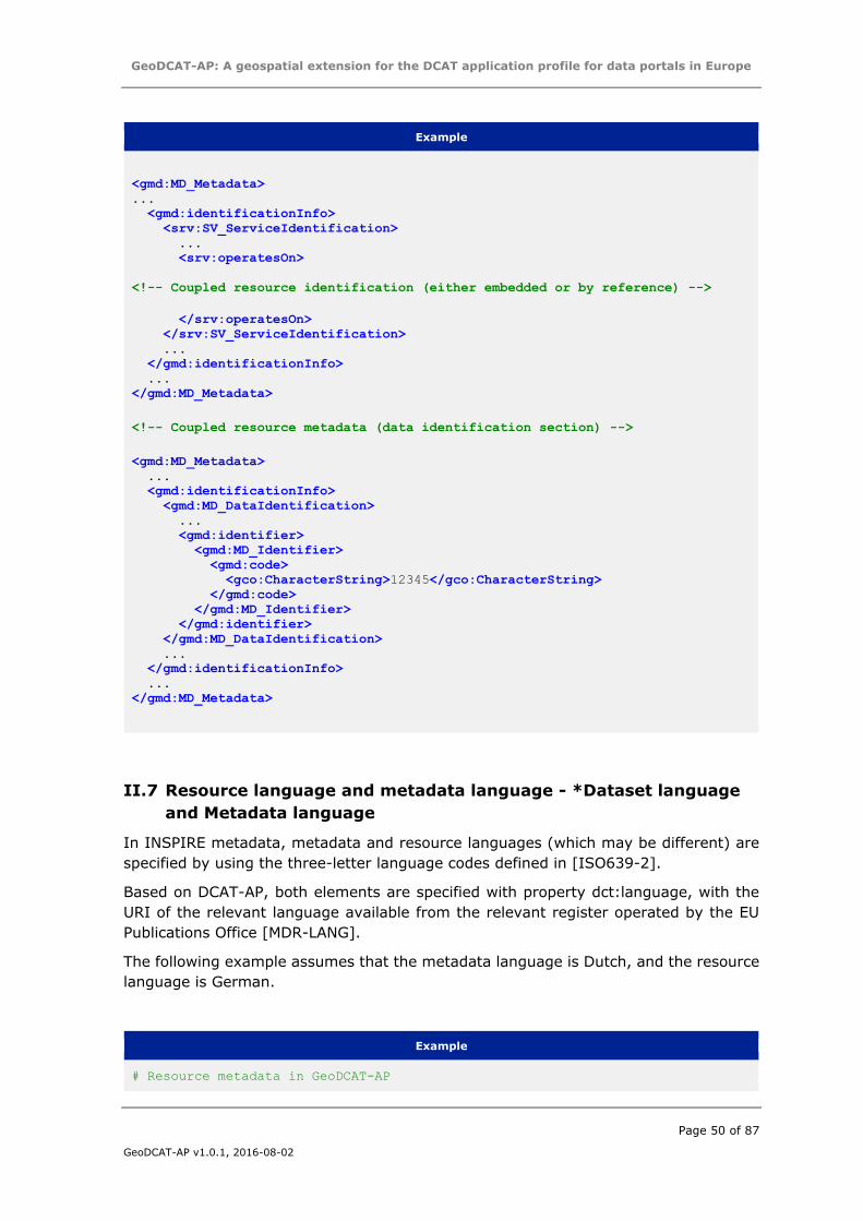
GeoDCAT-AP: A geospatial extension for the DCAT application profile for data portals in Europe
Page 50 of 87
GeoDCAT-AP v1.0.1, 2016-08-02
Example
<gmd:MD_Metadata>
...
<gmd:identificationInfo>
<srv:SV_ServiceIdentification>
...
<srv:operatesOn>
<!-- Coupled resource identification (either embedded or by reference) -->
</srv:operatesOn>
</srv:SV_ServiceIdentification>
...
</gmd:identificationInfo>
...
</gmd:MD_Metadata>
<!-- Coupled resource metadata (data identification section) -->
<gmd:MD_Metadata>
...
<gmd:identificationInfo>
<gmd:MD_DataIdentification>
...
<gmd:identifier>
<gmd:MD_Identifier>
<gmd:code>
<gco:CharacterString>12345</gco:CharacterString>
</gmd:code>
</gmd:MD_Identifier>
</gmd:identifier>
</gmd:MD_DataIdentification>
...
</gmd:identificationInfo>
...
</gmd:MD_Metadata>
II.7 Resource language and metadata language - *Dataset language
and Metadata language
In INSPIRE metadata, metadata and resource languages (which may be different) are
specified by using the three-letter language codes defined in [ISO639-2].
Based on DCAT-AP, both elements are specified with property dct:language, with the
URI of the relevant language available from the relevant register operated by the EU
Publications Office [MDR-LANG].
The following example assumes that the metadata language is Dutch, and the resource
language is German.
Example
# Resource metadata in GeoDCAT-AP
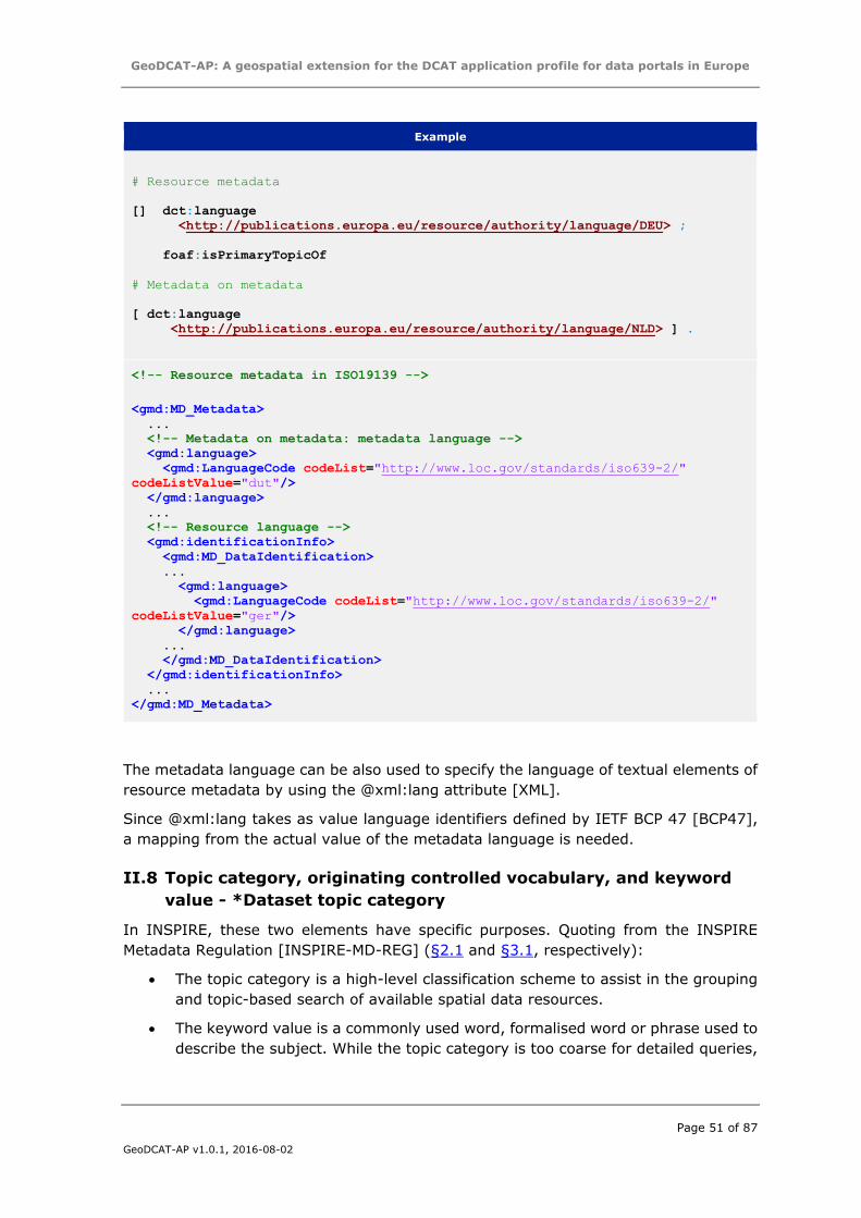
GeoDCAT-AP: A geospatial extension for the DCAT application profile for data portals in Europe
Page 51 of 87
GeoDCAT-AP v1.0.1, 2016-08-02
Example
# Resource metadata
[] dct:language
<http://publications.europa.eu/resource/authority/language/DEU> ;
foaf:isPrimaryTopicOf
# Metadata on metadata
[ dct:language
<http://publications.europa.eu/resource/authority/language/NLD> ] .
<!-- Resource metadata in ISO19139 -->
<gmd:MD_Metadata>
...
<!-- Metadata on metadata: metadata language -->
<gmd:language>
<gmd:LanguageCode codeList="http://www.loc.gov/standards/iso639-2/"
codeListValue="dut"/>
</gmd:language>
...
<!-- Resource language -->
<gmd:identificationInfo>
<gmd:MD_DataIdentification>
...
<gmd:language>
<gmd:LanguageCode codeList="http://www.loc.gov/standards/iso639-2/"
codeListValue="ger"/>
</gmd:language>
...
</gmd:MD_DataIdentification>
</gmd:identificationInfo>
...
</gmd:MD_Metadata>
The metadata language can be also used to specify the language of textual elements of
resource metadata by using the @xml:lang attribute [XML].
Since @xml:lang takes as value language identifiers defined by IETF BCP 47 [BCP47],
a mapping from the actual value of the metadata language is needed.
II.8 Topic category, originating controlled vocabulary, and keyword
value - *Dataset topic category
In INSPIRE, these two elements have specific purposes. Quoting from the INSPIRE
Metadata Regulation [INSPIRE-MD-REG] (§2.1 and §3.1, respectively):
The topic category is a high-level classification scheme to assist in the grouping
and topic-based search of available spatial data resources.
The keyword value is a commonly used word, formalised word or phrase used to
describe the subject. While the topic category is too coarse for detailed queries,
GeoDCAT-AP: A geospatial extension for the DCAT application profile for data portals in Europe
Page 52 of 87
GeoDCAT-AP v1.0.1, 2016-08-02
keywords help narrowing a full text search and they allow for structured keyword
search.
Moreover, two types of keywords are allowed:
free keywords;
keywords taken from a controlled vocabulary.
Finally, topic categories apply only to datasets and dataset series.
II.8.1 Topic category and keyword in datasets and dataset series
As far as dataset metadata are concerned, in both DCAT and DCAT-AP, a distinction is
made only between free keywords and keywords from controlled vocabularies,
associated with a URI. For the former, dcat:keyword is used, whereas for the latter
dcat:theme (which is a sub-property of dct:subject). Since the INSPIRE Registry
operates URI registers for topic categories and INSPIRE spatial data themes, and in
order to keep the distinction existing in INSPIRE between topic categories and
keywords, the mapping is as follows:
Topic category is mapped to dct:subject, and expressed by the corresponding
URIs minted for the ISO code list in the INSPIRE Registry – reference register:
o http://inspire.ec.europa.eu/metadata-codelist/TopicCategory
Keywords not associated with a controlled vocabulary will be mapped to
dcat:keyword;
INSPIRE spatial data themes are mapped to dcat:theme and expressed by the
corresponding URI in the INSPIRE Registry – reference register:
http://inspire.ec.europa.eu/theme
Keywords associated with other controlled vocabularies are mapped to
dcat:theme.
Following DCAT-AP recommendations, keywords from controlled vocabularies should be
preferably specified with dereferenceable HTTP URIs. In such a case, the information
concerning the originating controlled vocabulary can be omitted.
When keywords cannot be specified with HTTP URIs, they should be modelled as a
skos:Concept associated with a skos:ConceptScheme (modelling the originating
controlled vocabulary), and annotated with the textual content and reference date(s) in
the relevant INSPIRE metadata elements.
The representation of the information concerning the controlled vocabulary is illustrated
in the following table.
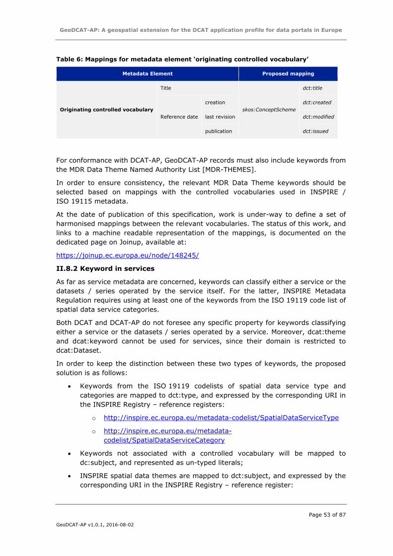
GeoDCAT-AP: A geospatial extension for the DCAT application profile for data portals in Europe
Page 53 of 87
GeoDCAT-AP v1.0.1, 2016-08-02
Table 6: Mappings for metadata element ‘originating controlled vocabulary’
Metadata Element Proposed mapping
Originating controlled vocabulary
Title
skos:ConceptScheme
dct:title
Reference date
creation dct:created
last revision dct:modified
publication dct:issued
For conformance with DCAT-AP, GeoDCAT-AP records must also include keywords from
the MDR Data Theme Named Authority List [MDR-THEMES].
In order to ensure consistency, the relevant MDR Data Theme keywords should be
selected based on mappings with the controlled vocabularies used in INSPIRE /
ISO 19115 metadata.
At the date of publication of this specification, work is under-way to define a set of
harmonised mappings between the relevant vocabularies. The status of this work, and
links to a machine readable representation of the mappings, is documented on the
dedicated page on Joinup, available at:
https://joinup.ec.europa.eu/node/148245/
II.8.2 Keyword in services
As far as service metadata are concerned, keywords can classify either a service or the
datasets / series operated by the service itself. For the latter, INSPIRE Metadata
Regulation requires using at least one of the keywords from the ISO 19119 code list of
spatial data service categories.
Both DCAT and DCAT-AP do not foresee any specific property for keywords classifying
either a service or the datasets / series operated by a service. Moreover, dcat:theme
and dcat:keyword cannot be used for services, since their domain is restricted to
dcat:Dataset.
In order to keep the distinction between these two types of keywords, the proposed
solution is as follows:
Keywords from the ISO 19119 codelists of spatial data service type and
categories are mapped to dct:type, and expressed by the corresponding URI in
the INSPIRE Registry – reference registers:
o http://inspire.ec.europa.eu/metadata-codelist/SpatialDataServiceType
o http://inspire.ec.europa.eu/metadata-
codelist/SpatialDataServiceCategory
Keywords not associated with a controlled vocabulary will be mapped to
dc:subject, and represented as un-typed literals;
INSPIRE spatial data themes are mapped to dct:subject, and expressed by the
corresponding URI in the INSPIRE Registry – reference register:
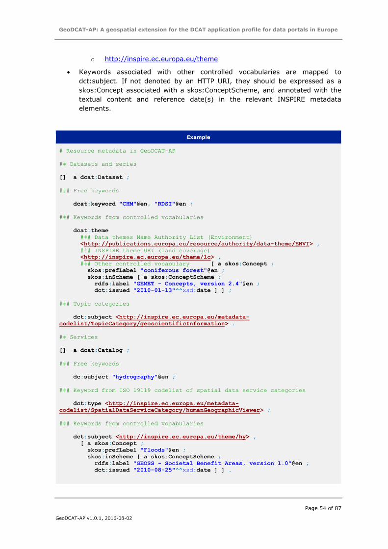
GeoDCAT-AP: A geospatial extension for the DCAT application profile for data portals in Europe
Page 54 of 87
GeoDCAT-AP v1.0.1, 2016-08-02
o http://inspire.ec.europa.eu/theme
Keywords associated with other controlled vocabularies are mapped to
dct:subject. If not denoted by an HTTP URI, they should be expressed as a
skos:Concept associated with a skos:ConceptScheme, and annotated with the
textual content and reference date(s) in the relevant INSPIRE metadata
elements.
Example
# Resource metadata in GeoDCAT-AP
## Datasets and series
[] a dcat:Dataset ;
### Free keywords
dcat:keyword "CHM"@en, "RDSI"@en ;
### Keywords from controlled vocabularies
dcat:theme
### Data themes Name Authority List (Environment)
<http://publications.europa.eu/resource/authority/data-theme/ENVI> ,
### INSPIRE theme URI (land coverage)
<http://inspire.ec.europa.eu/theme/lc> ,
### Other controlled vocabulary [ a skos:Concept ;
skos:prefLabel "coniferous forest"@en ;
skos:inScheme [ a skos:ConceptScheme ;
rdfs:label "GEMET - Concepts, version 2.4"@en ;
dct:issued "2010-01-13"^^xsd:date ] ] ;
### Topic categories
dct:subject <http://inspire.ec.europa.eu/metadata-
codelist/TopicCategory/geoscientificInformation> .
## Services
[] a dcat:Catalog ;
### Free keywords
dc:subject "hydrography"@en ;
### Keyword from ISO 19119 codelist of spatial data service categories
dct:type <http://inspire.ec.europa.eu/metadata-
codelist/SpatialDataServiceCategory/humanGeographicViewer> ;
### Keywords from controlled vocabularies
dct:subject <http://inspire.ec.europa.eu/theme/hy> ,
[ a skos:Concept ;
skos:prefLabel "Floods"@en ;
skos:inScheme [ a skos:ConceptScheme ;
rdfs:label "GEOSS - Societal Benefit Areas, version 1.0"@en ;
dct:issued "2010-08-25"^^xsd:date ] ] .
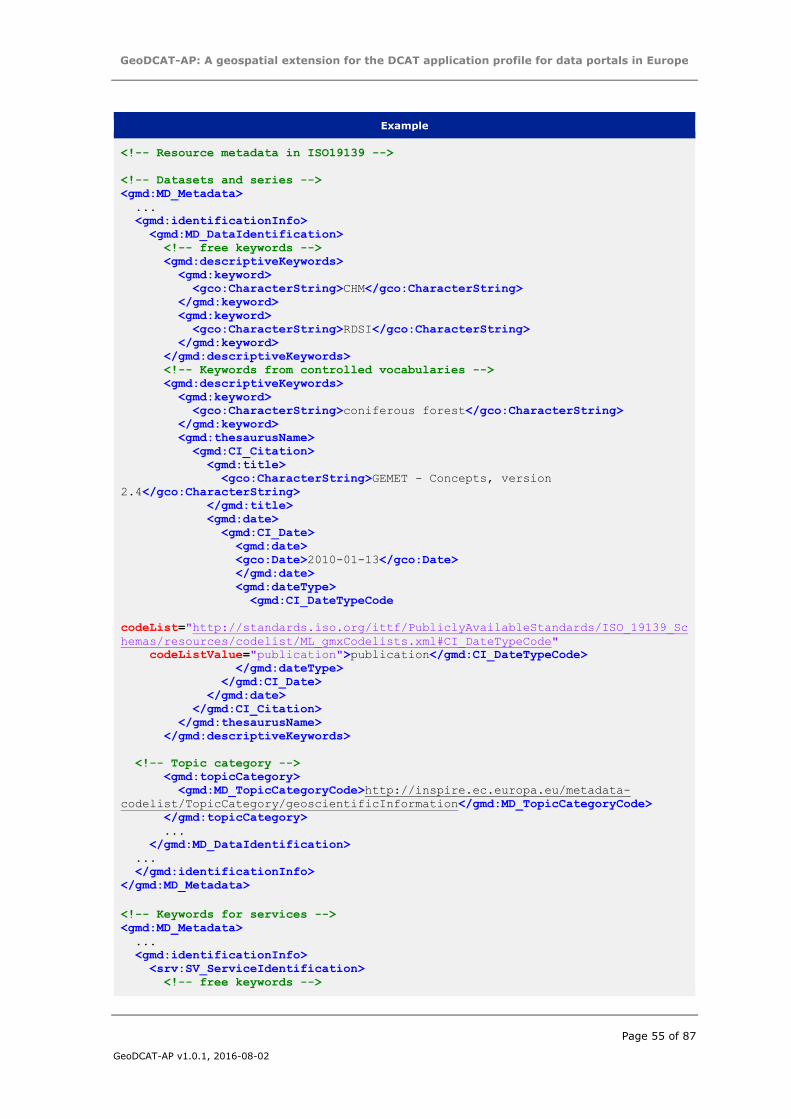
GeoDCAT-AP: A geospatial extension for the DCAT application profile for data portals in Europe
Page 55 of 87
GeoDCAT-AP v1.0.1, 2016-08-02
Example
<!-- Resource metadata in ISO19139 -->
<!-- Datasets and series -->
<gmd:MD_Metadata>
...
<gmd:identificationInfo>
<gmd:MD_DataIdentification>
<!-- free keywords -->
<gmd:descriptiveKeywords>
<gmd:keyword>
<gco:CharacterString>CHM</gco:CharacterString>
</gmd:keyword>
<gmd:keyword>
<gco:CharacterString>RDSI</gco:CharacterString>
</gmd:keyword>
</gmd:descriptiveKeywords>
<!-- Keywords from controlled vocabularies -->
<gmd:descriptiveKeywords>
<gmd:keyword>
<gco:CharacterString>coniferous forest</gco:CharacterString>
</gmd:keyword>
<gmd:thesaurusName>
<gmd:CI_Citation>
<gmd:title>
<gco:CharacterString>GEMET - Concepts, version
2.4</gco:CharacterString>
</gmd:title>
<gmd:date>
<gmd:CI_Date>
<gmd:date>
<gco:Date>2010-01-13</gco:Date>
</gmd:date>
<gmd:dateType>
<gmd:CI_DateTypeCode
codeList="http://standards.iso.org/ittf/PubliclyAvailableStandards/ISO_19139_Sc
hemas/resources/codelist/ML_gmxCodelists.xml#CI_DateTypeCode"
codeListValue="publication">publication</gmd:CI_DateTypeCode>
</gmd:dateType>
</gmd:CI_Date>
</gmd:date>
</gmd:CI_Citation>
</gmd:thesaurusName>
</gmd:descriptiveKeywords>
<!-- Topic category -->
<gmd:topicCategory>
<gmd:MD_TopicCategoryCode>http://inspire.ec.europa.eu/metadata-
codelist/TopicCategory/geoscientificInformation</gmd:MD_TopicCategoryCode>
</gmd:topicCategory>
...
</gmd:MD_DataIdentification>
...
</gmd:identificationInfo>
</gmd:MD_Metadata>
<!-- Keywords for services -->
<gmd:MD_Metadata>
...
<gmd:identificationInfo>
<srv:SV_ServiceIdentification>
<!-- free keywords -->
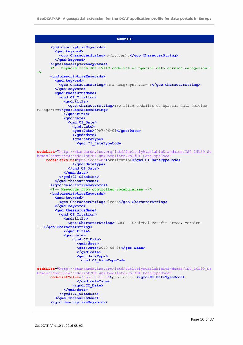
GeoDCAT-AP: A geospatial extension for the DCAT application profile for data portals in Europe
Page 56 of 87
GeoDCAT-AP v1.0.1, 2016-08-02
Example
<gmd:descriptiveKeywords>
<gmd:keyword>
<gco:CharacterString>hydrography</gco:CharacterString>
</gmd:keyword>
</gmd:descriptiveKeywords>
<!-- Keyword from ISO 19119 codelist of spatial data service categories -
->
<gmd:descriptiveKeywords>
<gmd:keyword>
<gco:CharacterString>humanGeographicViewer</gco:CharacterString>
</gmd:keyword>
<gmd:thesaurusName>
<gmd:CI_Citation>
<gmd:title>
<gco:CharacterString>ISO 19119 codelist of spatial data service
categories</gco:CharacterString>
</gmd:title>
<gmd:date>
<gmd:CI_Date>
<gmd:date>
<gco:Date>2007-06-01</gco:Date>
</gmd:date>
<gmd:dateType>
<gmd:CI_DateTypeCode
codeList="http://standards.iso.org/ittf/PubliclyAvailableStandards/ISO_19139_Sc
hemas/resources/codelist/ML_gmxCodelists.xml#CI_DateTypeCode"
codeListValue="publication">publication</gmd:CI_DateTypeCode>
</gmd:dateType>
</gmd:CI_Date>
</gmd:date>
</gmd:CI_Citation>
</gmd:thesaurusName>
</gmd:descriptiveKeywords>
<!-- Keywords from controlled vocabularies -->
<gmd:descriptiveKeywords>
<gmd:keyword>
<gco:CharacterString>Floods</gco:CharacterString>
</gmd:keyword>
<gmd:thesaurusName>
<gmd:CI_Citation>
<gmd:title>
<gco:CharacterString>GEOSS - Societal Benefit Areas, version
1.0</gco:CharacterString>
</gmd:title>
<gmd:date>
<gmd:CI_Date>
<gmd:date>
<gco:Date>2010-08-25</gco:Date>
</gmd:date>
<gmd:dateType>
<gmd:CI_DateTypeCode
codeList="http://standards.iso.org/ittf/PubliclyAvailableStandards/ISO_19139_Sc
hemas/resources/codelist/ML_gmxCodelists.xml#CI_DateTypeCode"
codeListValue="publication">publication</gmd:CI_DateTypeCode>
</gmd:dateType>
</gmd:CI_Date>
</gmd:date>
</gmd:CI_Citation>
</gmd:thesaurusName>
</gmd:descriptiveKeywords>
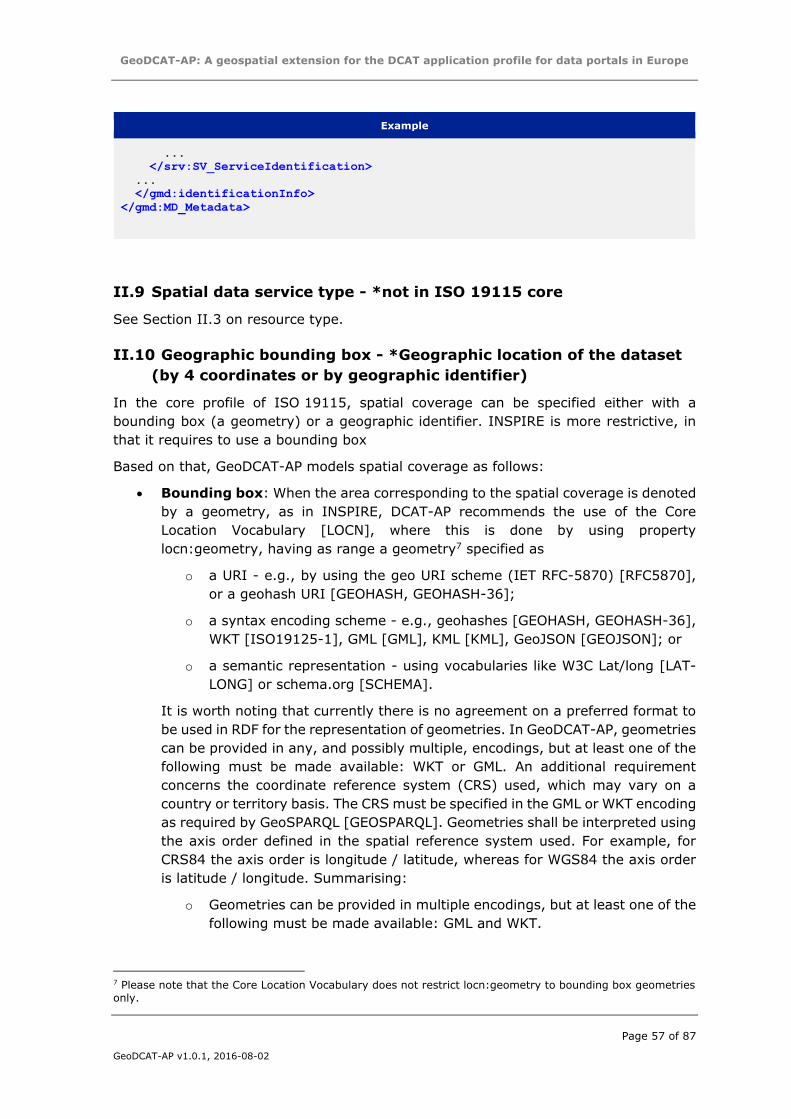
GeoDCAT-AP: A geospatial extension for the DCAT application profile for data portals in Europe
Page 57 of 87
GeoDCAT-AP v1.0.1, 2016-08-02
Example
...
</srv:SV_ServiceIdentification>
...
</gmd:identificationInfo>
</gmd:MD_Metadata>
II.9 Spatial data service type - *not in ISO 19115 core
See Section II.3 on resource type.
II.10 Geographic bounding box - *Geographic location of the dataset
(by 4 coordinates or by geographic identifier)
In the core profile of ISO 19115, spatial coverage can be specified either with a
bounding box (a geometry) or a geographic identifier. INSPIRE is more restrictive, in
that it requires to use a bounding box
Based on that, GeoDCAT-AP models spatial coverage as follows:
Bounding box: When the area corresponding to the spatial coverage is denoted
by a geometry, as in INSPIRE, DCAT-AP recommends the use of the Core
Location Vocabulary [LOCN], where this is done by using property
locn:geometry, having as range a geometry7 specified as
o a URI - e.g., by using the geo URI scheme (IET RFC-5870) [RFC5870],
or a geohash URI [GEOHASH, GEOHASH-36];
o a syntax encoding scheme - e.g., geohashes [GEOHASH, GEOHASH-36],
WKT [ISO19125-1], GML [GML], KML [KML], GeoJSON [GEOJSON]; or
o a semantic representation - using vocabularies like W3C Lat/long [LAT-
LONG] or schema.org [SCHEMA].
It is worth noting that currently there is no agreement on a preferred format to
be used in RDF for the representation of geometries. In GeoDCAT-AP, geometries
can be provided in any, and possibly multiple, encodings, but at least one of the
following must be made available: WKT or GML. An additional requirement
concerns the coordinate reference system (CRS) used, which may vary on a
country or territory basis. The CRS must be specified in the GML or WKT encoding
as required by GeoSPARQL [GEOSPARQL]. Geometries shall be interpreted using
the axis order defined in the spatial reference system used. For example, for
CRS84 the axis order is longitude / latitude, whereas for WGS84 the axis order
is latitude / longitude. Summarising:
o Geometries can be provided in multiple encodings, but at least one of the
following must be made available: GML and WKT.
7 Please note that the Core Location Vocabulary does not restrict locn:geometry to bounding box geometries
only.

GeoDCAT-AP: A geospatial extension for the DCAT application profile for data portals in Europe
Page 58 of 87
GeoDCAT-AP v1.0.1, 2016-08-02
o For GML and WKT, the CRS must be specified as defined in GeoSPARQL
[GEOSPARQL].
Geographic identifier: ISO 19115 core also allows specifying the geographic
location using a geographic identifier. Following DCAT-AP, for this, it is
recommended to use an HTTP URI from one of the following registers /
gazetteers:
o The Named Authority Lists operated by the Metadata Registry of the EU
Publications office concerning continents [MDR-CONT], countries [MD-
COUNTRIES], and places [MDR-PLACES].
o If none of the above provides the relevant geographic identifiers,
Geonames [GEONAMES] should be used.
If an HTTP URI is not available, the geographical identifier must be expressed
with skos:prefLabel, and the reference to the originating controlled vocabulary
(if any) must be specified with skos:inScheme. The controlled vocabulary will be
described by a name (dct:title) and a last modified data (dct:modified).
As far as geographic identifiers are concerned, following DCAT-AP, GeoDCAT-AP does
not prevent the use other vocabularies in addition to the recommended ones. The
vocabularies identified by the GeoDCAT-AP WG are listed in Section 6 of the GeoDCAT-
AP specification.
The following example shows how to specify the spatial coverage.
Example
# Resource metadata in GeoDCAT-AP using a geographic bounding box. This example
uses multiple encodings, namely, the
# recommended ones (WKT and GML), plus GeoJSON. To denote the datatype of the
GeoJSON literal, the URL of the corresponding
# IANA media type.
[] dct:spatial [ a dct:Location ;
locn:geometry "POLYGON((-10.58 70.09,34.59 70.09,34.59 34.56,-10.58
34.56,
-10.58 70.09))"^^gsp:wktLiteral ;
locn:geometry "<gml:Envelope
srsName=\"http://www.opengis.net/def/crs/OGC/1.3/CRS84\">
<gml:lowerCorner>34.56 -10.58</gml:lowerCorner>
<gml:upperCorner>70.09 34.59</gml:upperCorner>
</gml:Envelope>"^^gsp:gmlLiteral ] ;
locn:geometry
"{\"type\":\"Polygon\",\"crs\":{\"type\":\"name\",\"properties\":{\"name\":\"ur
n:ogc:def:crs:OGC:1.3:CRS84\"}},
\"coordinates\":[[[-
10.58,70.09],[34.59,70.09],[34.59,34.56],[-10.58,34.56],[-10.58,70.09]]]
}"^^<https://www.iana.org/assignments/media-
types/application/vnd.geo+json> ].
# Resource metadata in GeoDCAT-AP using a geographic identifier
#If a URI is used for the geographic identifier (recommended)
[]
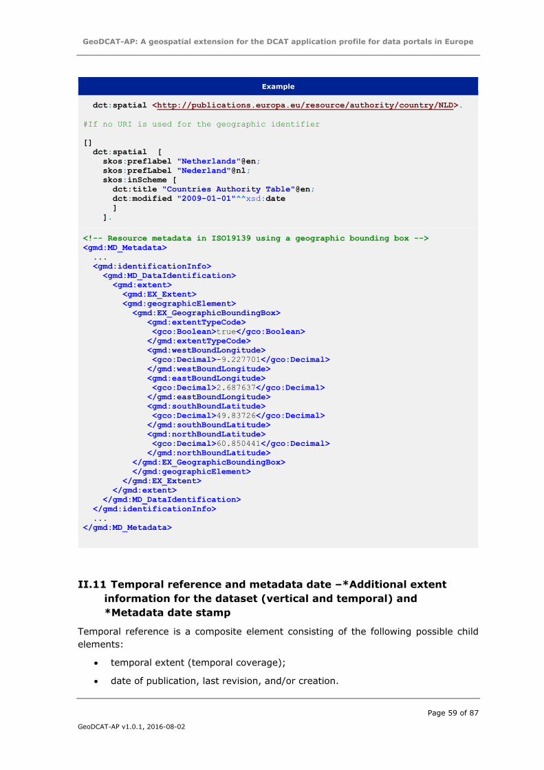
GeoDCAT-AP: A geospatial extension for the DCAT application profile for data portals in Europe
Page 59 of 87
GeoDCAT-AP v1.0.1, 2016-08-02
Example
dct:spatial <http://publications.europa.eu/resource/authority/country/NLD>.
#If no URI is used for the geographic identifier
[]
dct:spatial [
skos:preflabel "Netherlands"@en;
skos:prefLabel "Nederland"@nl;
skos:inScheme [
dct:title "Countries Authority Table"@en;
dct:modified "2009-01-01"^^xsd:date
]
].
<!-- Resource metadata in ISO19139 using a geographic bounding box -->
<gmd:MD_Metadata>
...
<gmd:identificationInfo>
<gmd:MD_DataIdentification>
<gmd:extent>
<gmd:EX_Extent>
<gmd:geographicElement>
<gmd:EX_GeographicBoundingBox>
<gmd:extentTypeCode>
<gco:Boolean>true</gco:Boolean>
</gmd:extentTypeCode>
<gmd:westBoundLongitude>
<gco:Decimal>-9.227701</gco:Decimal>
</gmd:westBoundLongitude>
<gmd:eastBoundLongitude>
<gco:Decimal>2.687637</gco:Decimal>
</gmd:eastBoundLongitude>
<gmd:southBoundLatitude>
<gco:Decimal>49.83726</gco:Decimal>
</gmd:southBoundLatitude>
<gmd:northBoundLatitude>
<gco:Decimal>60.850441</gco:Decimal>
</gmd:northBoundLatitude>
</gmd:EX_GeographicBoundingBox>
</gmd:geographicElement>
</gmd:EX_Extent>
</gmd:extent>
</gmd:MD_DataIdentification>
</gmd:identificationInfo>
...
</gmd:MD_Metadata>
II.11 Temporal reference and metadata date –*Additional extent
information for the dataset (vertical and temporal) and
*Metadata date stamp
Temporal reference is a composite element consisting of the following possible child
elements:
temporal extent (temporal coverage);
date of publication, last revision, and/or creation.
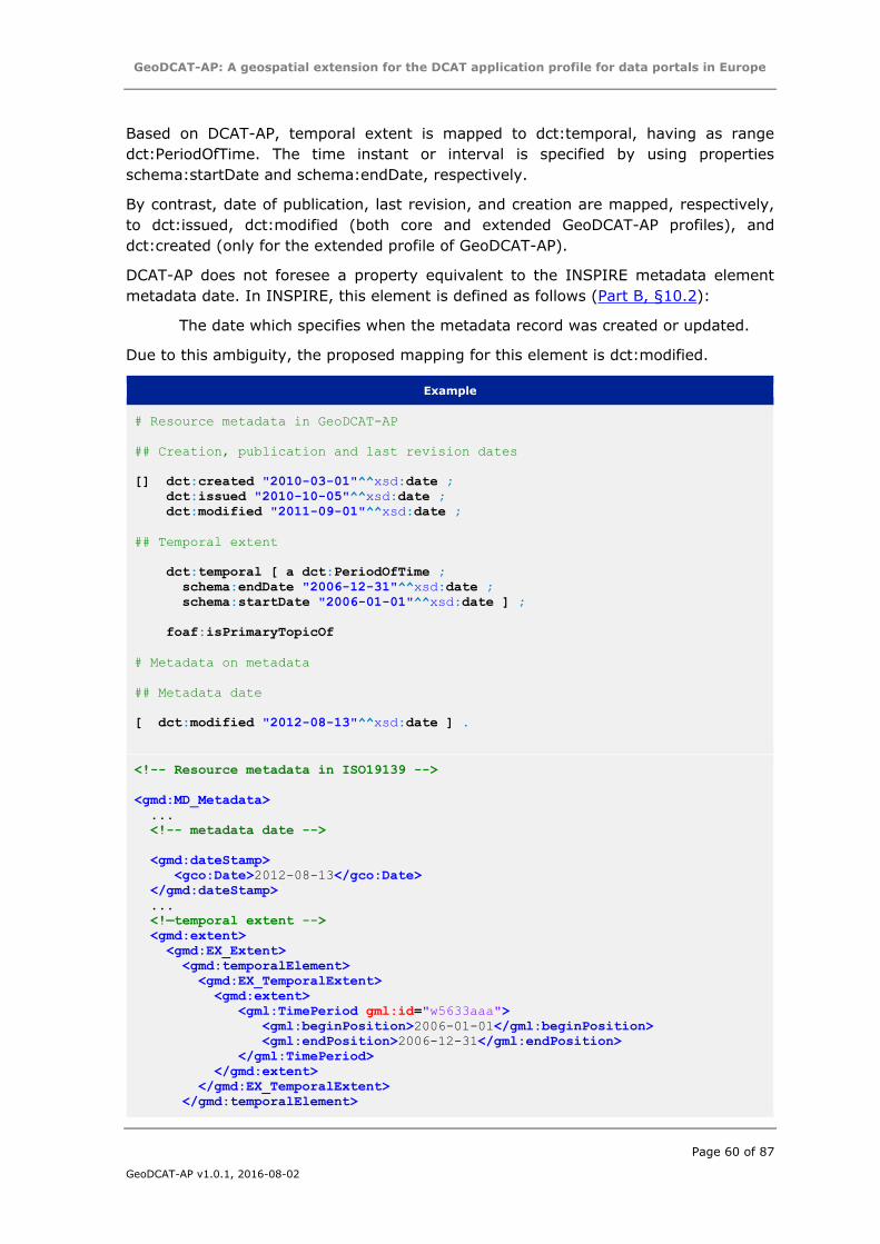
GeoDCAT-AP: A geospatial extension for the DCAT application profile for data portals in Europe
Page 60 of 87
GeoDCAT-AP v1.0.1, 2016-08-02
Based on DCAT-AP, temporal extent is mapped to dct:temporal, having as range
dct:PeriodOfTime. The time instant or interval is specified by using properties
schema:startDate and schema:endDate, respectively.
By contrast, date of publication, last revision, and creation are mapped, respectively,
to dct:issued, dct:modified (both core and extended GeoDCAT-AP profiles), and
dct:created (only for the extended profile of GeoDCAT-AP).
DCAT-AP does not foresee a property equivalent to the INSPIRE metadata element
metadata date. In INSPIRE, this element is defined as follows (Part B, §10.2):
The date which specifies when the metadata record was created or updated.
Due to this ambiguity, the proposed mapping for this element is dct:modified.
Example
# Resource metadata in GeoDCAT-AP
## Creation, publication and last revision dates
[] dct:created "2010-03-01"^^xsd:date ;
dct:issued "2010-10-05"^^xsd:date ;
dct:modified "2011-09-01"^^xsd:date ;
## Temporal extent
dct:temporal [ a dct:PeriodOfTime ;
schema:endDate "2006-12-31"^^xsd:date ;
schema:startDate "2006-01-01"^^xsd:date ] ;
foaf:isPrimaryTopicOf
# Metadata on metadata
## Metadata date
[ dct:modified "2012-08-13"^^xsd:date ] .
<!-- Resource metadata in ISO19139 -->
<gmd:MD_Metadata>
...
<!-- metadata date -->
<gmd:dateStamp>
<gco:Date>2012-08-13</gco:Date>
</gmd:dateStamp>
...
<!—temporal extent -->
<gmd:extent>
<gmd:EX_Extent>
<gmd:temporalElement>
<gmd:EX_TemporalExtent>
<gmd:extent>
<gml:TimePeriod gml:id="w5633aaa">
<gml:beginPosition>2006-01-01</gml:beginPosition>
<gml:endPosition>2006-12-31</gml:endPosition>
</gml:TimePeriod>
</gmd:extent>
</gmd:EX_TemporalExtent>
</gmd:temporalElement>
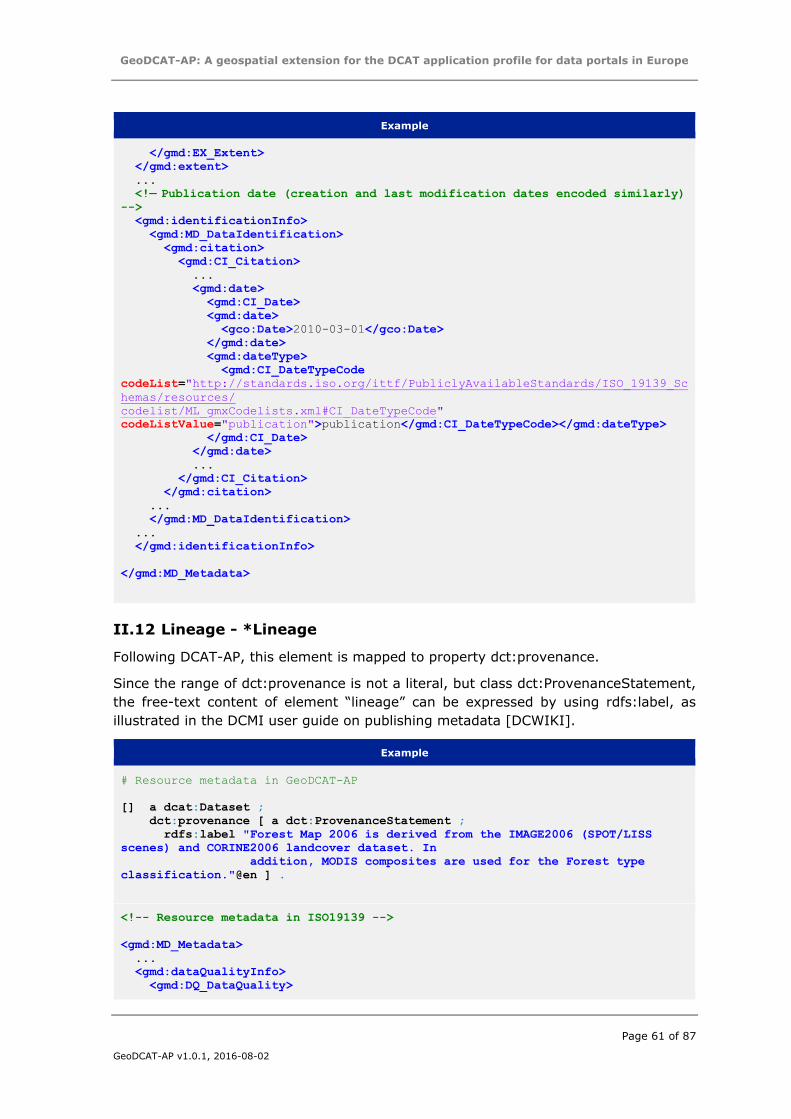
GeoDCAT-AP: A geospatial extension for the DCAT application profile for data portals in Europe
Page 61 of 87
GeoDCAT-AP v1.0.1, 2016-08-02
Example
</gmd:EX_Extent>
</gmd:extent>
...
<!— Publication date (creation and last modification dates encoded similarly) -->
<gmd:identificationInfo>
<gmd:MD_DataIdentification>
<gmd:citation>
<gmd:CI_Citation>
...
<gmd:date>
<gmd:CI_Date>
<gmd:date>
<gco:Date>2010-03-01</gco:Date>
</gmd:date>
<gmd:dateType>
<gmd:CI_DateTypeCode
codeList="http://standards.iso.org/ittf/PubliclyAvailableStandards/ISO_19139_Sc
hemas/resources/
codelist/ML_gmxCodelists.xml#CI_DateTypeCode"
codeListValue="publication">publication</gmd:CI_DateTypeCode></gmd:dateType>
</gmd:CI_Date>
</gmd:date>
...
</gmd:CI_Citation>
</gmd:citation>
...
</gmd:MD_DataIdentification>
...
</gmd:identificationInfo>
</gmd:MD_Metadata>
II.12 Lineage - *Lineage
Following DCAT-AP, this element is mapped to property dct:provenance.
Since the range of dct:provenance is not a literal, but class dct:ProvenanceStatement,
the free-text content of element “lineage” can be expressed by using rdfs:label, as
illustrated in the DCMI user guide on publishing metadata [DCWIKI].
Example
# Resource metadata in GeoDCAT-AP
[] a dcat:Dataset ;
dct:provenance [ a dct:ProvenanceStatement ;
rdfs:label "Forest Map 2006 is derived from the IMAGE2006 (SPOT/LISS
scenes) and CORINE2006 landcover dataset. In
addition, MODIS composites are used for the Forest type
classification."@en ] .
<!-- Resource metadata in ISO19139 -->
<gmd:MD_Metadata>
...
<gmd:dataQualityInfo>
<gmd:DQ_DataQuality>

GeoDCAT-AP: A geospatial extension for the DCAT application profile for data portals in Europe
Page 62 of 87
GeoDCAT-AP v1.0.1, 2016-08-02
Example
<gmd:lineage>
<gmd:LI_Lineage>
<gmd:statement>
<gco:CharacterString> Forest Map 2006 is derived from the IMAGE2006
(SPOT/LISS scenes) and CORINE2006 landcover dataset. In addition, MODIS
composites are used for the Forest type classification.
</gco:CharacterString>
</gmd:statement>
</gmd:LI_Lineage>
</gmd:lineage>
</gmd:DQ_DataQuality>
</gmd:dataQualityInfo>
...
</gmd:MD_Metadata>
II.13 Spatial resolution – Spatial resolution of the dataset
In DCAT-AP, no equivalent term is foreseen.
There are currently no candidates in existing vocabularies to represent such metadata
elements.
Based on this, GeoDCAT-AP defines a provisional mapping, representing spatial
resolution in a human-readable form only, using property rdfs:comment.
Example
# Resource metadata in GeoDCAT-AP
# Spatial resolution as equivalent scale
[] a dcat:Dataset ;
rdfs:comment "Spatial resolution (equivalent scale): 1:10000"@en .
# Spatial resolution as distance
[] a dcat:Dataset ;
rdfs:comment "Spatial resolution (distance): 5 km"@en .
<!-- Resource metadata in ISO19139 -->
<gmd:MD_Resolution>
<gmd:equivalentScale>
<gmd:MD_RepresentativeFraction>
<gmd:denominator>
<gco:Integer>10000</gco:Integer>
</gmd:denominator>
</gmd:MD_RepresentativeFraction>
</gmd:equivalentScale>
</gmd:MD_Resolution>
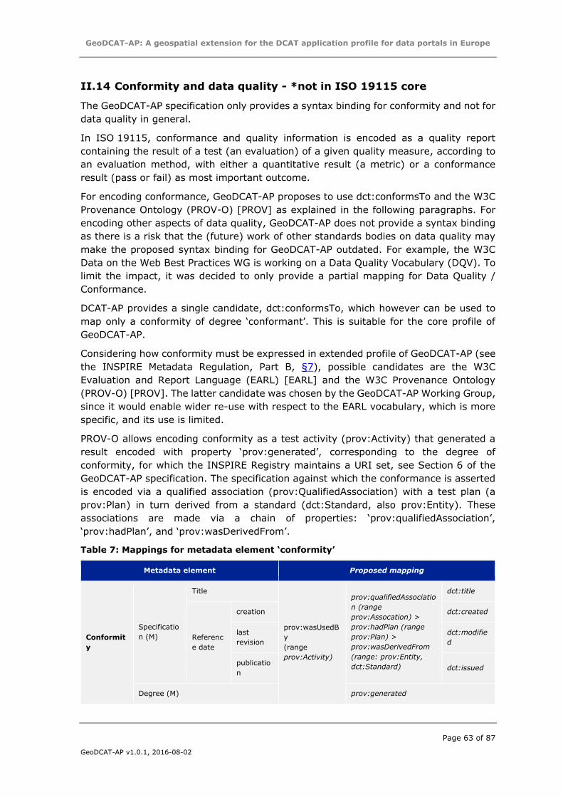
GeoDCAT-AP: A geospatial extension for the DCAT application profile for data portals in Europe
Page 63 of 87
GeoDCAT-AP v1.0.1, 2016-08-02
II.14 Conformity and data quality - *not in ISO 19115 core
The GeoDCAT-AP specification only provides a syntax binding for conformity and not for
data quality in general.
In ISO 19115, conformance and quality information is encoded as a quality report
containing the result of a test (an evaluation) of a given quality measure, according to
an evaluation method, with either a quantitative result (a metric) or a conformance
result (pass or fail) as most important outcome.
For encoding conformance, GeoDCAT-AP proposes to use dct:conformsTo and the W3C
Provenance Ontology (PROV-O) [PROV] as explained in the following paragraphs. For
encoding other aspects of data quality, GeoDCAT-AP does not provide a syntax binding
as there is a risk that the (future) work of other standards bodies on data quality may
make the proposed syntax binding for GeoDCAT-AP outdated. For example, the W3C
Data on the Web Best Practices WG is working on a Data Quality Vocabulary (DQV). To
limit the impact, it was decided to only provide a partial mapping for Data Quality /
Conformance.
DCAT-AP provides a single candidate, dct:conformsTo, which however can be used to
map only a conformity of degree ‘conformant’. This is suitable for the core profile of
GeoDCAT-AP.
Considering how conformity must be expressed in extended profile of GeoDCAT-AP (see
the INSPIRE Metadata Regulation, Part B, §7), possible candidates are the W3C
Evaluation and Report Language (EARL) [EARL] and the W3C Provenance Ontology
(PROV-O) [PROV]. The latter candidate was chosen by the GeoDCAT-AP Working Group,
since it would enable wider re-use with respect to the EARL vocabulary, which is more
specific, and its use is limited.
PROV-O allows encoding conformity as a test activity (prov:Activity) that generated a
result encoded with property ‘prov:generated’, corresponding to the degree of
conformity, for which the INSPIRE Registry maintains a URI set, see Section 6 of the
GeoDCAT-AP specification. The specification against which the conformance is asserted
is encoded via a qualified association (prov:QualifiedAssociation) with a test plan (a
prov:Plan) in turn derived from a standard (dct:Standard, also prov:Entity). These
associations are made via a chain of properties: ‘prov:qualifiedAssociation’,
‘prov:hadPlan’, and ‘prov:wasDerivedFrom’.
Table 7: Mappings for metadata element ‘conformity’
Metadata element Proposed mapping
Conformit
y
Specificatio
n (M)
Title
prov:wasUsedB
y
(range
prov:Activity)
prov:qualifiedAssociatio
n (range
prov:Assocation) >
prov:hadPlan (range
prov:Plan) >
prov:wasDerivedFrom
(range: prov:Entity,
dct:Standard)
dct:title
Referenc
e date
creation dct:created
last
revision
dct:modifie
d
publicatio
n dct:issued
Degree (M) prov:generated
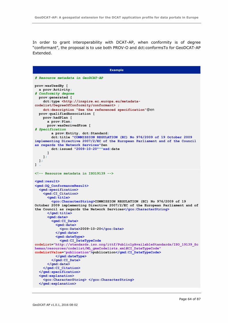
GeoDCAT-AP: A geospatial extension for the DCAT application profile for data portals in Europe
Page 64 of 87
GeoDCAT-AP v1.0.1, 2016-08-02
In order to grant interoperability with DCAT-AP, when conformity is of degree
“conformant”, the proposal is to use both PROV-O and dct:conformsTo for GeoDCAT-AP
Extended.
Example
# Resource metadata in GeoDCAT-AP
prov:wasUsedBy [
a prov:Activity;
# Conformity degree
prov:generated [
dct:type <http://inspire.ec.europa.eu/metadata-
codelist/DegreeOfConformity/conformant> ;
dct:description “See the referenced specification”@en prov:qualifiedAssociation [
prov:hadPlan [
a prov:Plan;
prov:wasDerivedFrom [
# Specification
a prov:Entity, dct:Standard;
dct:title "COMMISSION REGULATION (EC) No 976/2009 of 19 October 2009
implementing Directive 2007/2/EC of the European Parliament and of the Council
as regards the Network Services"@en
dct:issued "2009-10-20"^^xsd:date
]
];
];
] .
<!-- Resource metadata in ISO19139 -->
<gmd:result>
<gmd:DQ_ConformanceResult>
<gmd:specification>
<gmd:CI_Citation>
<gmd:title>
<gco:CharacterString>COMMISSION REGULATION (EC) No 976/2009 of 19
October 2009 implementing Directive 2007/2/EC of the European Parliament and of
the Council as regards the Network Services</gco:CharacterString>
</gmd:title>
<gmd:date>
<gmd:CI_Date>
<gmd:date>
<gco:Date>2009-10-20</gco:Date>
</gmd:date>
<gmd:dateType>
<gmd:CI_DateTypeCode
codeList="http://standards.iso.org/ittf/PubliclyAvailableStandards/ISO_19139_Sc
hemas/resources/codelist/ML_gmxCodelists.xml#CI_DateTypeCode"
codeListValue="publication">publication</gmd:CI_DateTypeCode>
</gmd:dateType>
</gmd:CI_Date>
</gmd:date>
</gmd:CI_Citation>
</gmd:specification>
<gmd:explanation>
<gco:CharacterString> </gco:CharacterString>
</gmd:explanation>
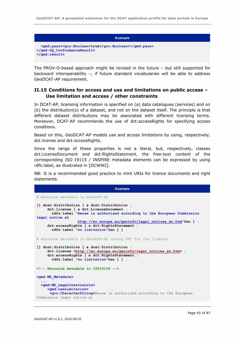
GeoDCAT-AP: A geospatial extension for the DCAT application profile for data portals in Europe
Page 65 of 87
GeoDCAT-AP v1.0.1, 2016-08-02
Example
<gmd:pass><gco:Boolean>true</gco:Boolean></gmd:pass>
</gmd:DQ_ConformanceResult>
</gmd:result>
The PROV-O-based approach might be revised in the future – but still supported for
backward interoperability –, if future standard vocabularies will be able to address
GeoDCAT-AP requirement.
II.15 Conditions for access and use and limitations on public access –
Use limitation and access / other constraints
In DCAT-AP, licensing information is specified on (a) data catalogues (services) and on
(b) the distribution(s) of a dataset, and not on the dataset itself. The principle is that
different dataset distributions may be associated with different licensing terms.
Moreover, DCAT-AP recommends the use of dct:accessRights for specifying access
conditions.
Based on this, GeoDCAT-AP models use and access limitations by using, respectively,
dct:license and dct:accessRights.
Since the range of these properties is not a literal, but, respectively, classes
dct:LicenseDocument and dct:RightsStatement, the free-text content of the
corresponding ISO 19115 / INSPIRE metadata elements can be expressed by using
rdfs:label, as illustrated in [DCWIKI].
NB: It is a recommended good practice to mint URIs for licence documents and right
statements.
Example
# Resource metadata in GeoDCAT-AP
[] dcat:distribution [ a dcat:Distribution ;
dct:license [ a dct:LicenseDocument ;
rdfs:label "Reuse is authorised according to the European Commission
legal notice at
http://ec.europa.eu/geninfo/legal_notices_en.htm"@en ] ;
dct:accessRights [ a dct:RightsStatement ;
rdfs:label "no limitation"@en ] ] .
# Resource metadata in GeoDCAT-AP (using URI for the licence)
[] dcat:distribution [ a dcat:Distribution ;
dct:license <http://ec.europa.eu/geninfo/legal_notices_en.htm> ;
dct:accessRights [ a dct:RightsStatement ;
rdfs:label "no limitation"@en ] ] .
<!-- Resource metadata in ISO19139 -->
<gmd:MD_Metadata>
...
<gmd:MD_LegalConstraints>
<gmd:useLimitation>
<gco:CharacterString>Reuse is authorised according to the European
Commission legal notice at
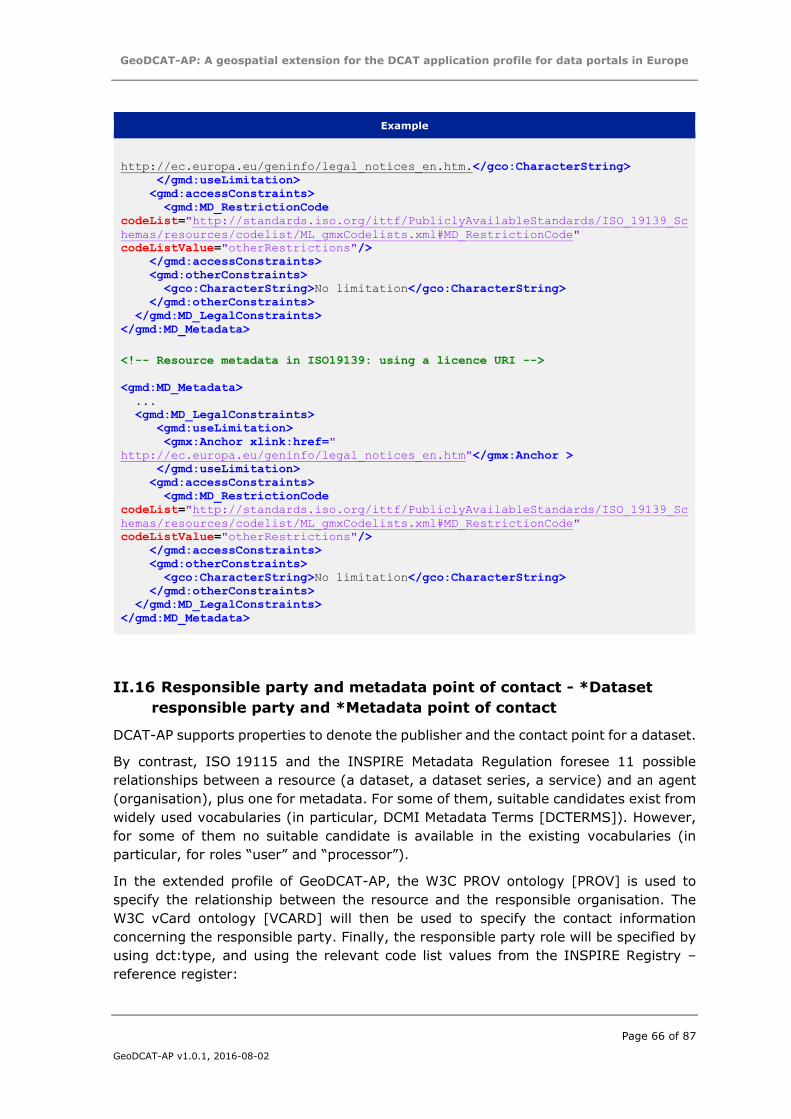
GeoDCAT-AP: A geospatial extension for the DCAT application profile for data portals in Europe
Page 66 of 87
GeoDCAT-AP v1.0.1, 2016-08-02
Example
http://ec.europa.eu/geninfo/legal_notices_en.htm.</gco:CharacterString>
</gmd:useLimitation>
<gmd:accessConstraints>
<gmd:MD_RestrictionCode
codeList="http://standards.iso.org/ittf/PubliclyAvailableStandards/ISO_19139_Sc
hemas/resources/codelist/ML_gmxCodelists.xml#MD_RestrictionCode"
codeListValue="otherRestrictions"/>
</gmd:accessConstraints>
<gmd:otherConstraints>
<gco:CharacterString>No limitation</gco:CharacterString>
</gmd:otherConstraints>
</gmd:MD_LegalConstraints>
</gmd:MD_Metadata>
<!-- Resource metadata in ISO19139: using a licence URI -->
<gmd:MD_Metadata>
...
<gmd:MD_LegalConstraints>
<gmd:useLimitation>
<gmx:Anchor xlink:href="
http://ec.europa.eu/geninfo/legal_notices_en.htm"</gmx:Anchor >
</gmd:useLimitation>
<gmd:accessConstraints>
<gmd:MD_RestrictionCode
codeList="http://standards.iso.org/ittf/PubliclyAvailableStandards/ISO_19139_Sc
hemas/resources/codelist/ML_gmxCodelists.xml#MD_RestrictionCode"
codeListValue="otherRestrictions"/>
</gmd:accessConstraints>
<gmd:otherConstraints>
<gco:CharacterString>No limitation</gco:CharacterString>
</gmd:otherConstraints>
</gmd:MD_LegalConstraints>
</gmd:MD_Metadata>
II.16 Responsible party and metadata point of contact - *Dataset
responsible party and *Metadata point of contact
DCAT-AP supports properties to denote the publisher and the contact point for a dataset.
By contrast, ISO 19115 and the INSPIRE Metadata Regulation foresee 11 possible
relationships between a resource (a dataset, a dataset series, a service) and an agent
(organisation), plus one for metadata. For some of them, suitable candidates exist from
widely used vocabularies (in particular, DCMI Metadata Terms [DCTERMS]). However,
for some of them no suitable candidate is available in the existing vocabularies (in
particular, for roles “user” and “processor”).
In the extended profile of GeoDCAT-AP, the W3C PROV ontology [PROV] is used to
specify the relationship between the resource and the responsible organisation. The
W3C vCard ontology [VCARD] will then be used to specify the contact information
concerning the responsible party. Finally, the responsible party role will be specified by
using dct:type, and using the relevant code list values from the INSPIRE Registry –
reference register:
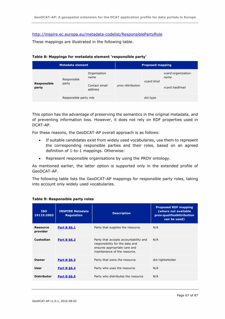
GeoDCAT-AP: A geospatial extension for the DCAT application profile for data portals in Europe
Page 67 of 87
GeoDCAT-AP v1.0.1, 2016-08-02
http://inspire.ec.europa.eu/metadata-codelist/ResponsiblePartyRole
These mappings are illustrated in the following table.
Table 8: Mappings for metadata element ‘responsible party’
Metadata element Proposed mapping
Responsible
party
Responsible
party
Organisation
name
prov:Attribution
vcard:Kind
vcard:organization-
name
Contact email
address vcard:hasEmail
Responsible party role dct:type
This option has the advantage of preserving the semantics in the original metadata, and
of preventing information loss. However, it does not rely on RDF properties used in
DCAT-AP.
For these reasons, the GeoDCAT-AP overall approach is as follows:
If suitable candidates exist from widely used vocabularies, use them to represent
the corresponding responsible parties and their roles, based on an agreed
definition of 1-to-1 mappings. Otherwise:
Represent responsible organisations by using the PROV ontology.
As mentioned earlier, the latter option is supported only in the extended profile of
GeoDCAT-AP.
The following table lists the GeoDCAT-AP mappings for responsible party roles, taking
into account only widely used vocabularies.
Table 9: Responsible party roles
ISO
19115:2003
INSPIRE Metadata
Regulation Description
Proposed RDF mapping
(where not available
prov:qualifiedAttribution
can be used)
Resource
provider
Part B §6.1 Party that supplies the resource. N/A
Custodian Part B §6.2 Party that accepts accountability and
responsibility for the data and
ensures appropriate care and
maintenance of the resource.
N/A
Owner Part B §6.3 Party that owns the resource. dct:rightsHolder
User Part B §6.4 Party who uses the resource. N/A
Distributor Part B §6.5 Party who distributes the resource N/A
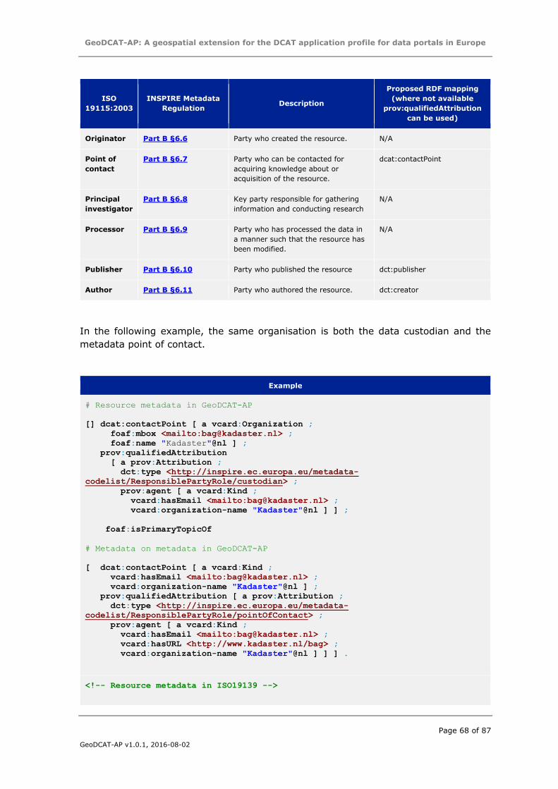
GeoDCAT-AP: A geospatial extension for the DCAT application profile for data portals in Europe
Page 68 of 87
GeoDCAT-AP v1.0.1, 2016-08-02
ISO
19115:2003
INSPIRE Metadata
Regulation Description
Proposed RDF mapping
(where not available
prov:qualifiedAttribution
can be used)
Originator Part B §6.6 Party who created the resource. N/A
Point of
contact
Part B §6.7 Party who can be contacted for
acquiring knowledge about or
acquisition of the resource.
dcat:contactPoint
Principal
investigator
Part B §6.8 Key party responsible for gathering
information and conducting research
N/A
Processor Part B §6.9 Party who has processed the data in
a manner such that the resource has
been modified.
N/A
Publisher Part B §6.10 Party who published the resource dct:publisher
Author Part B §6.11 Party who authored the resource. dct:creator
In the following example, the same organisation is both the data custodian and the
metadata point of contact.
Example
# Resource metadata in GeoDCAT-AP
[] dcat:contactPoint [ a vcard:Organization ;
foaf:mbox <mailto:[email protected]> ;
foaf:name "Kadaster"@nl ] ;
prov:qualifiedAttribution
[ a prov:Attribution ;
dct:type <http://inspire.ec.europa.eu/metadata-
codelist/ResponsiblePartyRole/custodian> ;
prov:agent [ a vcard:Kind ;
vcard:hasEmail <mailto:[email protected]> ;
vcard:organization-name "Kadaster"@nl ] ] ;
foaf:isPrimaryTopicOf
# Metadata on metadata in GeoDCAT-AP
[ dcat:contactPoint [ a vcard:Kind ;
vcard:hasEmail <mailto:[email protected]> ;
vcard:organization-name "Kadaster"@nl ] ;
prov:qualifiedAttribution [ a prov:Attribution ;
dct:type <http://inspire.ec.europa.eu/metadata-
codelist/ResponsiblePartyRole/pointOfContact> ;
prov:agent [ a vcard:Kind ;
vcard:hasEmail <mailto:[email protected]> ;
vcard:hasURL <http://www.kadaster.nl/bag> ;
vcard:organization-name "Kadaster"@nl ] ] ] .
<!-- Resource metadata in ISO19139 -->
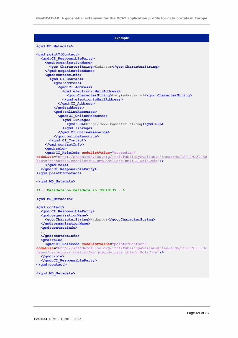
GeoDCAT-AP: A geospatial extension for the DCAT application profile for data portals in Europe
Page 69 of 87
GeoDCAT-AP v1.0.1, 2016-08-02
Example
<gmd:MD_Metadata>
...
<gmd:pointOfContact>
<gmd:CI_ResponsibleParty>
<gmd:organisationName>
<gco:CharacterString>Kadaster</gco:CharacterString>
</gmd:organisationName>
<gmd:contactInfo>
<gmd:CI_Contact>
<gmd:address>
<gmd:CI_Address>
<gmd:electronicMailAddress>
<gco:CharacterString>[email protected]</gco:CharacterString>
</gmd:electronicMailAddress>
</gmd:CI_Address>
</gmd:address>
<gmd:onlineResource>
<gmd:CI_OnlineResource>
<gmd:linkage>
<gmd:URL>http://www.kadaster.nl/bag</gmd:URL>
</gmd:linkage>
</gmd:CI_OnlineResource>
</gmd:onlineResource>
</gmd:CI_Contact>
</gmd:contactInfo>
<gmd:role>
<gmd:CI_RoleCode codeListValue="custodian"
codeList="http://standards.iso.org/ittf/PubliclyAvailableStandards/ISO_19139_Sc
hemas/resources/codelist/ML_gmxCodelists.xml#CI_RoleCode"/>
</gmd:role>
</gmd:CI_ResponsibleParty>
</gmd:pointOfContact>
...
</gmd:MD_Metadata>
<!-- Metadata on metadata in ISO19139 -->
<gmd:MD_Metadata>
...
<gmd:contact>
<gmd:CI_ResponsibleParty>
<gmd:organisationName>
<gco:CharacterString>Kadaster</gco:CharacterString>
</gmd:organisationName>
<gmd:contactInfo>
...
</gmd:contactInfo>
<gmd:role>
<gmd:CI_RoleCode codeListValue="pointofContact"
codeList="http://standards.iso.org/ittf/PubliclyAvailableStandards/ISO_19139_Sc
hemas/resources/codelist/ML_gmxCodelists.xml#CI_RoleCode"/>
</gmd:role>
</gmd:CI_ResponsibleParty>
</gmd:contact>
...
</gmd:MD_Metadata>
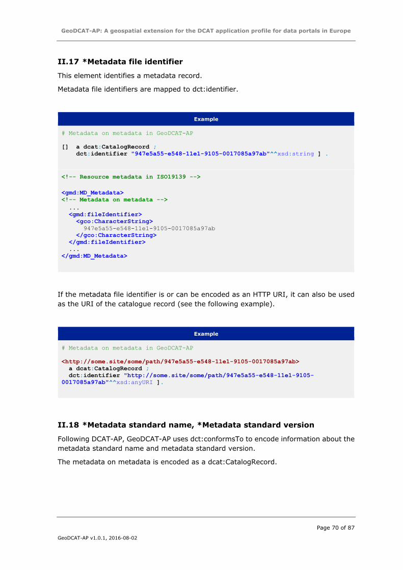
GeoDCAT-AP: A geospatial extension for the DCAT application profile for data portals in Europe
Page 70 of 87
GeoDCAT-AP v1.0.1, 2016-08-02
II.17 *Metadata file identifier
This element identifies a metadata record.
Metadata file identifiers are mapped to dct:identifier.
Example
# Metadata on metadata in GeoDCAT-AP
[] a dcat:CatalogRecord ;
dct:identifier "947e5a55-e548-11e1-9105-0017085a97ab"^^xsd:string ] .
<!-- Resource metadata in ISO19139 -->
<gmd:MD_Metadata>
<!-- Metadata on metadata -->
...
<gmd:fileIdentifier>
<gco:CharacterString>
947e5a55-e548-11e1-9105-0017085a97ab
</gco:CharacterString>
</gmd:fileIdentifier>
...
</gmd:MD_Metadata>
If the metadata file identifier is or can be encoded as an HTTP URI, it can also be used
as the URI of the catalogue record (see the following example).
Example
# Metadata on metadata in GeoDCAT-AP
<http://some.site/some/path/947e5a55-e548-11e1-9105-0017085a97ab>
a dcat:CatalogRecord ;
dct:identifier "http://some.site/some/path/947e5a55-e548-11e1-9105-
0017085a97ab"^^xsd:anyURI ].
II.18 *Metadata standard name, *Metadata standard version
Following DCAT-AP, GeoDCAT-AP uses dct:conformsTo to encode information about the
metadata standard name and metadata standard version.
The metadata on metadata is encoded as a dcat:CatalogRecord.
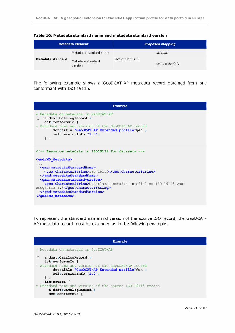
GeoDCAT-AP: A geospatial extension for the DCAT application profile for data portals in Europe
Page 71 of 87
GeoDCAT-AP v1.0.1, 2016-08-02
Table 10: Metadata standard name and metadata standard version
Metadata element Proposed mapping
Metadata standard
Metadata standard name
dct:conformsTo
dct:title
Metadata standard
version owl:versionInfo
The following example shows a GeoDCAT-AP metadata record obtained from one
conformant with ISO 19115.
Example
# Metadata on metadata in GeoDCAT-AP
[] a dcat:CatalogRecord ;
dct:conformsTo [
# Standard name and version of the GeoDCAT-AP record
dct:title "GeoDCAT-AP Extended profile"@en ;
owl:versionInfo "1.0".
] .
<!-- Resource metadata in ISO19139 for datasets -->
<gmd:MD_Metadata>
...
<gmd:metadataStandardName>
<gco:CharacterString>ISO 19115</gco:CharacterString>
</gmd:metadataStandardName>
<gmd:metadataStandardVersion>
<gco:CharacterString>Nederlands metadata profiel op ISO 19115 voor
geografie 1.3</gco:CharacterString>
</gmd:metadataStandardVersion>
</gmd:MD_Metadata>
To represent the standard name and version of the source ISO record, the GeoDCAT-
AP metadata record must be extended as in the following example.
Example
# Metadata on metadata in GeoDCAT-AP
[] a dcat:CatalogRecord ;
dct:conformsTo [
# Standard name and version of the GeoDCAT-AP record
dct:title "GeoDCAT-AP Extended profile"@en ;
owl:versionInfo "1.0".
] ;
dct:source [
# Standard name and version of the source ISO 19115 record
a dcat:CatalogRecord ;
dct:conformsTo [
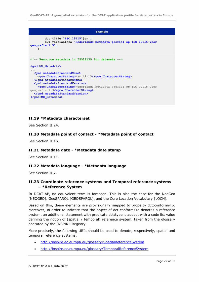
GeoDCAT-AP: A geospatial extension for the DCAT application profile for data portals in Europe
Page 72 of 87
GeoDCAT-AP v1.0.1, 2016-08-02
Example
dct:title "ISO 19115"@en ;
owl:versionInfo "Nederlands metadata profiel op ISO 19115 voor
geografie 1.3".
] .
<!-- Resource metadata in ISO19139 for datasets -->
<gmd:MD_Metadata>
...
<gmd:metadataStandardName>
<gco:CharacterString>ISO 19115</gco:CharacterString>
</gmd:metadataStandardName>
<gmd:metadataStandardVersion>
<gco:CharacterString>Nederlands metadata profiel op ISO 19115 voor
geografie 1.3</gco:CharacterString>
</gmd:metadataStandardVersion>
</gmd:MD_Metadata>
II.19 *Metadata characterset
See Section II.24.
II.20 Metadata point of contact - *Metadata point of contact
See Section II.16.
II.21 Metadata date - *Metadata date stamp
See Section II.11.
II.22 Metadata language - *Metadata language
See Section II.7.
II.23 Coordinate reference systems and Temporal reference systems
– *Reference System
In DCAT-AP, no equivalent term is foreseen. This is also the case for the NeoGeo
[NEOGEO], GeoSPARQL [GEOSPARQL], and the Core Location Vocabulary [LOCN].
Based on this, these elements are provisionally mapped to property dct:conformsTo.
Moreover, in order to indicate that the object of dct:conformsTo denotes a reference
system, an additional statement with predicate dct:type is added, with a code list value
defining the notion of (spatial / temporal) reference system, taken from the glossary
operated by the INSPIRE Registry.
More precisely, the following URIs should be used to denote, respectively, spatial and
temporal reference systems:
http://inspire.ec.europa.eu/glossary/SpatialReferenceSystem
http://inspire.ec.europa.eu/glossary/TemporalReferenceSystem
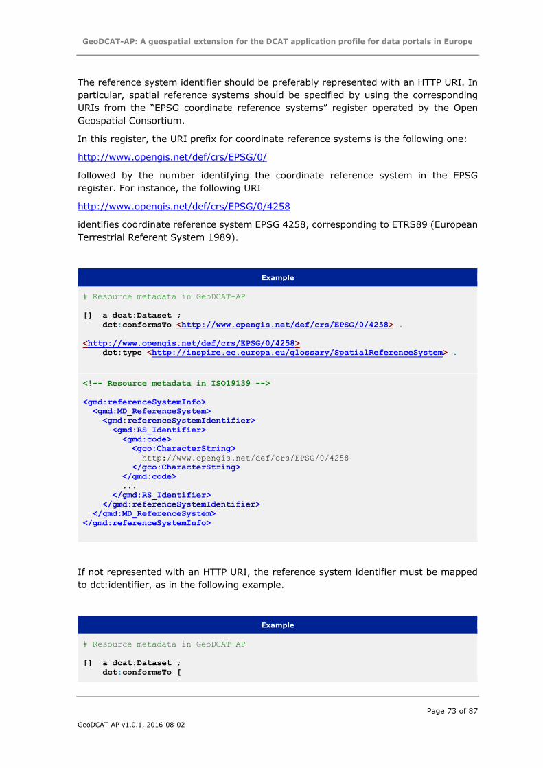
GeoDCAT-AP: A geospatial extension for the DCAT application profile for data portals in Europe
Page 73 of 87
GeoDCAT-AP v1.0.1, 2016-08-02
The reference system identifier should be preferably represented with an HTTP URI. In
particular, spatial reference systems should be specified by using the corresponding
URIs from the “EPSG coordinate reference systems” register operated by the Open
Geospatial Consortium.
In this register, the URI prefix for coordinate reference systems is the following one:
http://www.opengis.net/def/crs/EPSG/0/
followed by the number identifying the coordinate reference system in the EPSG
register. For instance, the following URI
http://www.opengis.net/def/crs/EPSG/0/4258
identifies coordinate reference system EPSG 4258, corresponding to ETRS89 (European
Terrestrial Referent System 1989).
Example
# Resource metadata in GeoDCAT-AP
[] a dcat:Dataset ;
dct:conformsTo <http://www.opengis.net/def/crs/EPSG/0/4258> .
<http://www.opengis.net/def/crs/EPSG/0/4258>
dct:type <http://inspire.ec.europa.eu/glossary/SpatialReferenceSystem> .
<!-- Resource metadata in ISO19139 -->
<gmd:referenceSystemInfo>
<gmd:MD_ReferenceSystem>
<gmd:referenceSystemIdentifier>
<gmd:RS_Identifier>
<gmd:code>
<gco:CharacterString>
http://www.opengis.net/def/crs/EPSG/0/4258
</gco:CharacterString>
</gmd:code>
...
</gmd:RS_Identifier>
</gmd:referenceSystemIdentifier>
</gmd:MD_ReferenceSystem>
</gmd:referenceSystemInfo>
If not represented with an HTTP URI, the reference system identifier must be mapped
to dct:identifier, as in the following example.
Example
# Resource metadata in GeoDCAT-AP
[] a dcat:Dataset ;
dct:conformsTo [
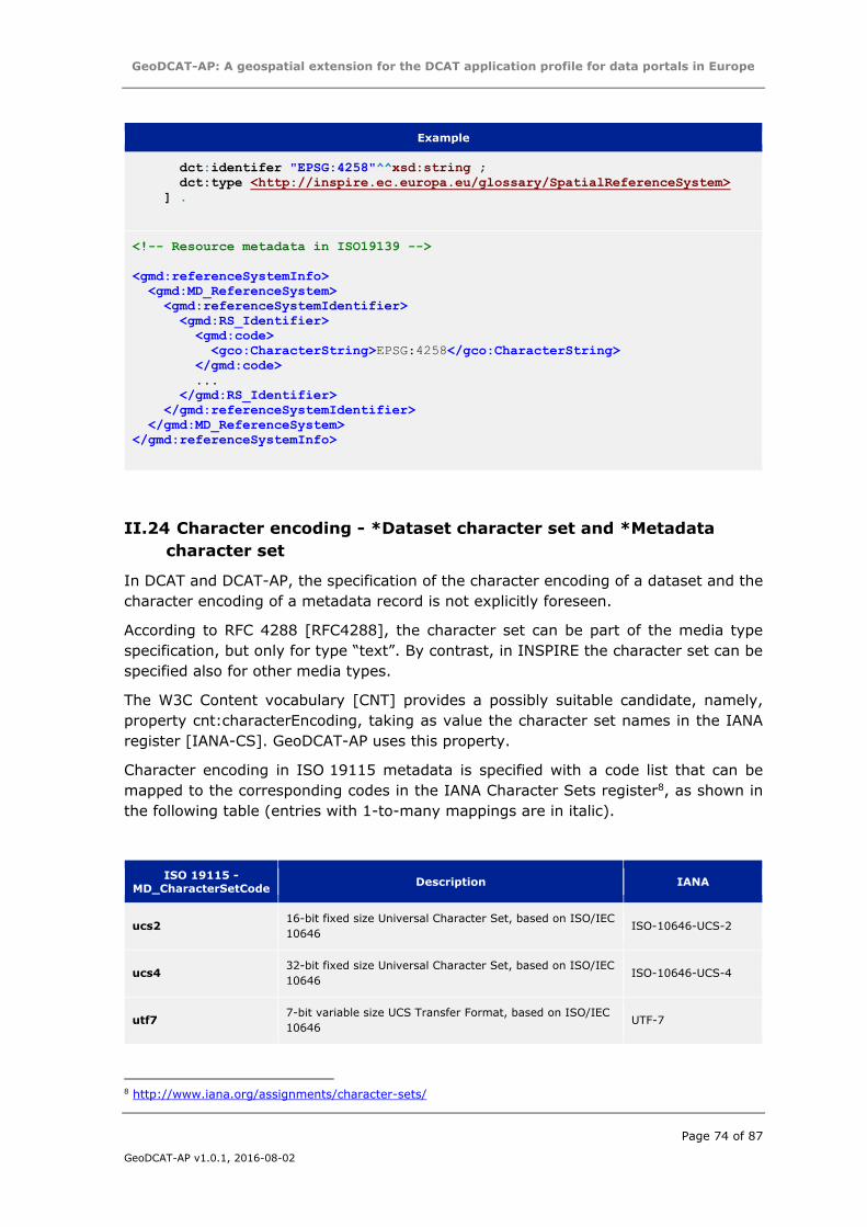
GeoDCAT-AP: A geospatial extension for the DCAT application profile for data portals in Europe
Page 74 of 87
GeoDCAT-AP v1.0.1, 2016-08-02
Example
dct:identifer "EPSG:4258"^^xsd:string ;
dct:type <http://inspire.ec.europa.eu/glossary/SpatialReferenceSystem>
] .
<!-- Resource metadata in ISO19139 -->
<gmd:referenceSystemInfo>
<gmd:MD_ReferenceSystem>
<gmd:referenceSystemIdentifier>
<gmd:RS_Identifier>
<gmd:code>
<gco:CharacterString>EPSG:4258</gco:CharacterString>
</gmd:code>
...
</gmd:RS_Identifier>
</gmd:referenceSystemIdentifier>
</gmd:MD_ReferenceSystem>
</gmd:referenceSystemInfo>
II.24 Character encoding - *Dataset character set and *Metadata
character set
In DCAT and DCAT-AP, the specification of the character encoding of a dataset and the
character encoding of a metadata record is not explicitly foreseen.
According to RFC 4288 [RFC4288], the character set can be part of the media type
specification, but only for type “text”. By contrast, in INSPIRE the character set can be
specified also for other media types.
The W3C Content vocabulary [CNT] provides a possibly suitable candidate, namely,
property cnt:characterEncoding, taking as value the character set names in the IANA
register [IANA-CS]. GeoDCAT-AP uses this property.
Character encoding in ISO 19115 metadata is specified with a code list that can be
mapped to the corresponding codes in the IANA Character Sets register8, as shown in
the following table (entries with 1-to-many mappings are in italic).
ISO 19115 -
MD_CharacterSetCode Description IANA
ucs2 16-bit fixed size Universal Character Set, based on ISO/IEC
10646 ISO-10646-UCS-2
ucs4 32-bit fixed size Universal Character Set, based on ISO/IEC
10646 ISO-10646-UCS-4
utf7 7-bit variable size UCS Transfer Format, based on ISO/IEC
10646 UTF-7
8 http://www.iana.org/assignments/character-sets/
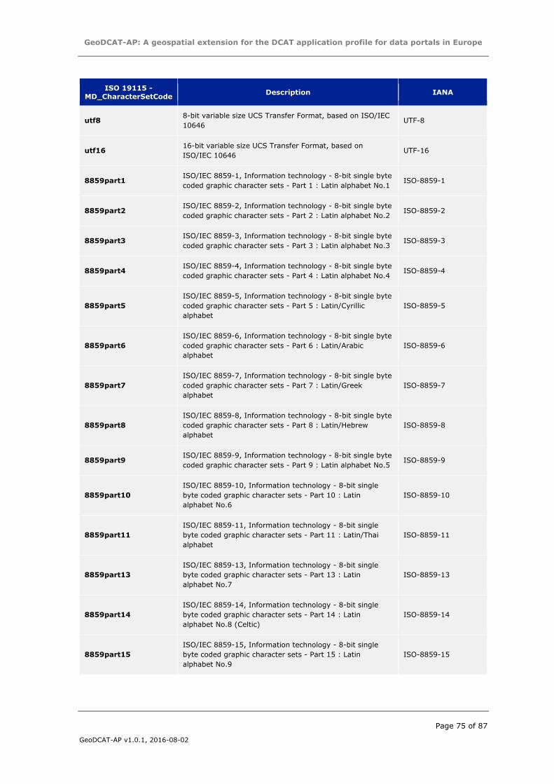
GeoDCAT-AP: A geospatial extension for the DCAT application profile for data portals in Europe
Page 75 of 87
GeoDCAT-AP v1.0.1, 2016-08-02
ISO 19115 -
MD_CharacterSetCode Description IANA
utf8 8-bit variable size UCS Transfer Format, based on ISO/IEC
10646 UTF-8
utf16 16-bit variable size UCS Transfer Format, based on
ISO/IEC 10646 UTF-16
8859part1 ISO/IEC 8859-1, Information technology - 8-bit single byte
coded graphic character sets - Part 1 : Latin alphabet No.1 ISO-8859-1
8859part2 ISO/IEC 8859-2, Information technology - 8-bit single byte
coded graphic character sets - Part 2 : Latin alphabet No.2 ISO-8859-2
8859part3 ISO/IEC 8859-3, Information technology - 8-bit single byte
coded graphic character sets - Part 3 : Latin alphabet No.3 ISO-8859-3
8859part4 ISO/IEC 8859-4, Information technology - 8-bit single byte
coded graphic character sets - Part 4 : Latin alphabet No.4 ISO-8859-4
8859part5
ISO/IEC 8859-5, Information technology - 8-bit single byte
coded graphic character sets - Part 5 : Latin/Cyrillic
alphabet
ISO-8859-5
8859part6
ISO/IEC 8859-6, Information technology - 8-bit single byte
coded graphic character sets - Part 6 : Latin/Arabic
alphabet
ISO-8859-6
8859part7
ISO/IEC 8859-7, Information technology - 8-bit single byte
coded graphic character sets - Part 7 : Latin/Greek
alphabet
ISO-8859-7
8859part8
ISO/IEC 8859-8, Information technology - 8-bit single byte
coded graphic character sets - Part 8 : Latin/Hebrew
alphabet
ISO-8859-8
8859part9 ISO/IEC 8859-9, Information technology - 8-bit single byte
coded graphic character sets - Part 9 : Latin alphabet No.5 ISO-8859-9
8859part10
ISO/IEC 8859-10, Information technology - 8-bit single
byte coded graphic character sets - Part 10 : Latin
alphabet No.6
ISO-8859-10
8859part11
ISO/IEC 8859-11, Information technology - 8-bit single
byte coded graphic character sets - Part 11 : Latin/Thai
alphabet
ISO-8859-11
8859part13
ISO/IEC 8859-13, Information technology - 8-bit single
byte coded graphic character sets - Part 13 : Latin
alphabet No.7
ISO-8859-13
8859part14
ISO/IEC 8859-14, Information technology - 8-bit single
byte coded graphic character sets - Part 14 : Latin
alphabet No.8 (Celtic)
ISO-8859-14
8859part15
ISO/IEC 8859-15, Information technology - 8-bit single
byte coded graphic character sets - Part 15 : Latin
alphabet No.9
ISO-8859-15
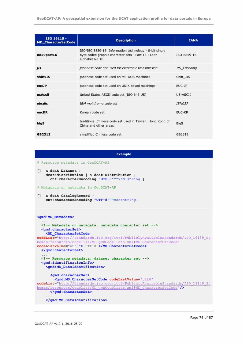
GeoDCAT-AP: A geospatial extension for the DCAT application profile for data portals in Europe
Page 76 of 87
GeoDCAT-AP v1.0.1, 2016-08-02
ISO 19115 -
MD_CharacterSetCode Description IANA
8859part16
ISO/IEC 8859-16, Information technology - 8-bit single
byte coded graphic character sets - Part 16 : Latin
alphabet No.10
ISO-8859-16
jis japanese code set used for electronic transmission JIS_Encoding
shiftJIS japanese code set used on MS-DOS machines Shift_JIS
eucJP japanese code set used on UNIX based machines EUC-JP
usAscii United States ASCII code set (ISO 646 US) US-ASCII
ebcdic IBM mainframe code set IBM037
eucKR Korean code set EUC-KR
big5 traditional Chinese code set used in Taiwan, Hong Kong of
China and other areas Big5
GB2312 simplified Chinese code set GB2312
Example
# Resource metadata in GeoDCAT-AP
[] a dcat:Dataset ;
dcat:distribution [ a dcat:Distribution ;
cnt:characterEncoding "UTF-8"^^xsd:string ] .
# Metadata on metadata in GeoDCAT-AP
[] a dcat:CatalogRecord ;
cnt:characterEncoding "UTF-8"^^xsd:string.
<gmd:MD_Metadata>
...
<!-- Metadata on metadata: metadata character set -->
<gmd:characterSet>
<MD_CharacterSetCode
codeList="http://standards.iso.org/ittf/PubliclyAvailableStandards/ISO_19139_Sc
hemas/resources/codelist/ML_gmxCodelists.xml#MD_CharacterSetCode"
codeListValue="utf8"> UTF-8 </MD_CharacterSetCode>
</gmd:characterSet>
...
<!-- Resource metadata: dataset character set -->
<gmd:identificationInfo>
<gmd:MD_DataIdentification>
...
<gmd:characterSet>
<gmd:MD_CharacterSetCode codeListValue="utf8"
codeList="http://standards.iso.org/ittf/PubliclyAvailableStandards/ISO_19139_Sc
hemas/resources/codelist/ML_gmxCodelists.xml#MD_CharacterSetCode"/>
</gmd:characterSet>
...
</gmd:MD_DataIdentification>
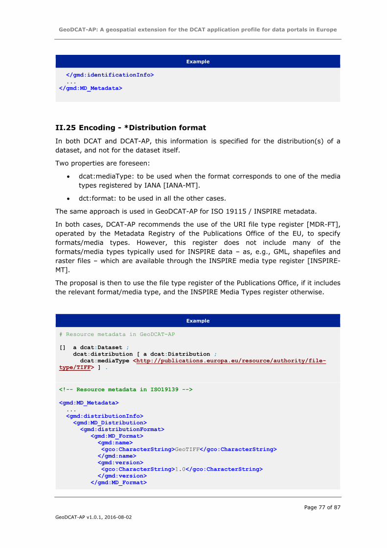
GeoDCAT-AP: A geospatial extension for the DCAT application profile for data portals in Europe
Page 77 of 87
GeoDCAT-AP v1.0.1, 2016-08-02
Example
</gmd:identificationInfo>
...
</gmd:MD_Metadata>
II.25 Encoding - *Distribution format
In both DCAT and DCAT-AP, this information is specified for the distribution(s) of a
dataset, and not for the dataset itself.
Two properties are foreseen:
dcat:mediaType: to be used when the format corresponds to one of the media
types registered by IANA [IANA-MT].
dct:format: to be used in all the other cases.
The same approach is used in GeoDCAT-AP for ISO 19115 / INSPIRE metadata.
In both cases, DCAT-AP recommends the use of the URI file type register [MDR-FT],
operated by the Metadata Registry of the Publications Office of the EU, to specify
formats/media types. However, this register does not include many of the
formats/media types typically used for INSPIRE data – as, e.g., GML, shapefiles and
raster files – which are available through the INSPIRE media type register [INSPIRE-
MT].
The proposal is then to use the file type register of the Publications Office, if it includes
the relevant format/media type, and the INSPIRE Media Types register otherwise.
Example
# Resource metadata in GeoDCAT-AP
[] a dcat:Dataset ;
dcat:distribution [ a dcat:Distribution ;
dcat:mediaType <http://publications.europa.eu/resource/authority/file-
type/TIFF> ] .
<!-- Resource metadata in ISO19139 -->
<gmd:MD_Metadata>
...
<gmd:distributionInfo>
<gmd:MD_Distribution>
<gmd:distributionFormat>
<gmd:MD_Format>
<gmd:name>
<gco:CharacterString>GeoTIFF</gco:CharacterString>
</gmd:name>
<gmd:version>
<gco:CharacterString>1.0</gco:CharacterString>
</gmd:version>
</gmd:MD_Format>
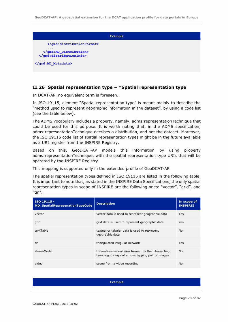
GeoDCAT-AP: A geospatial extension for the DCAT application profile for data portals in Europe
Page 78 of 87
GeoDCAT-AP v1.0.1, 2016-08-02
Example
</gmd:distributionFormat>
...
</gmd:MD_Distribution>
</gmd:distributionInfo>
...
</gmd:MD_Metadata>
II.26 Spatial representation type – *Spatial representation type
In DCAT-AP, no equivalent term is foreseen.
In ISO 19115, element “Spatial representation type” is meant mainly to describe the
“method used to represent geographic information in the dataset”, by using a code list
(see the table below).
The ADMS vocabulary includes a property, namely, adms:representationTechnique that
could be used for this purpose. It is worth noting that, in the ADMS specification,
adms:representationTechnique decribes a distribution, and not the dataset. Moreover,
the ISO 19115 code list of spatial representation types might be in the future available
as a URI register from the INSPIRE Registry.
Based on this, GeoDCAT-AP models this information by using property
adms:representationTechnique, with the spatial representation type URIs that will be
operated by the INSPIRE Registry.
This mapping is supported only in the extended profile of GeoDCAT-AP.
The spatial representation types defined in ISO 19115 are listed in the following table.
It is important to note that, as stated in the INSPIRE Data Specifications, the only spatial
representation types in scope of INSPIRE are the following ones: “vector”, “grid”, and
“tin”.
ISO 19115 -
MD_SpatialRepresenationTypeCode Description
In scope of
INSPIRE?
vector vector data is used to represent geographic data Yes
grid grid data is used to represent geographic data Yes
textTable textual or tabular data is used to represent
geographic data
No
tin triangulated irregular network Yes
stereoModel three-dimensional view formed by the intersecting
homologous rays of an overlapping pair of images
No
video scene from a video recording No
Example
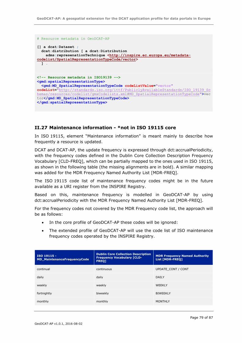
GeoDCAT-AP: A geospatial extension for the DCAT application profile for data portals in Europe
Page 79 of 87
GeoDCAT-AP v1.0.1, 2016-08-02
# Resource metadata in GeoDCAT-AP
[] a dcat:Dataset ;
dcat:distribution [ a dcat:Distribution
adms:represenationTechnique <http://inspire.ec.europa.eu/metadata-
codelist/SpatialRepresentationTypeCode/vector>
] .
<!-- Resource metadata in ISO19139 -->
<gmd:spatialRepresentationType>
<gmd:MD_SpatialRepresentationTypeCode codeListValue="vector"
codeList="http://standards.iso.org/ittf/PubliclyAvailableStandards/ISO_19139_Sc
hemas/resources/codelist/gmxCodelists.xml#MD_SpatialRepresentationTypeCode">vec
tor</gmd:MD_SpatialRepresentationTypeCode>
</gmd:spatialRepresentationType>
II.27 Maintenance information - *not in ISO 19115 core
In ISO 19115, element “Maintenance information” is meant mainly to describe how
frequently a resource is updated.
DCAT and DCAT-AP, the update frequency is expressed through dct:accrualPeriodicity,
with the frequency codes defined in the Dublin Core Collection Description Frequency
Vocabulary [CLD-FREQ], which can be partially mapped to the ones used in ISO 19115,
as shown in the following table (the missing alignments are in bold). A similar mapping
was added for the MDR Frequency Named Authority List [MDR-FREQ].
The ISO 19115 code list of maintenance frequency codes might be in the future
available as a URI register from the INSPIRE Registry.
Based on this, maintenance frequency is modelled in GeoDCAT-AP by using
dct:accrualPeriodicity with the MDR Frequency Named Authority List [MDR-FREQ].
For the frequency codes not covered by the MDR Frequency code list, the approach will
be as follows:
In the core profile of GeoDCAT-AP these codes will be ignored:
The extended profile of GeoDCAT-AP will use the code list of ISO maintenance
frequency codes operated by the INSPIRE Registry.
ISO 19115 - MD_MaintenanceFrequencyCode
Dublin Core Collection Description Frequency Vocabulary [CLD-FREQ]
MDR Frequency Named Authority List [MDR-FREQ]
continual continuous UPDATE_CONT / CONT
daily daily DAILY
weekly weekly WEEKLY
fortnightly biweekly BIWEEKLY
monthly monthly MONTHLY
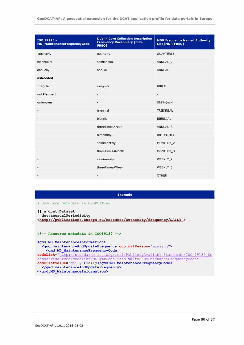
GeoDCAT-AP: A geospatial extension for the DCAT application profile for data portals in Europe
Page 80 of 87
GeoDCAT-AP v1.0.1, 2016-08-02
ISO 19115 - MD_MaintenanceFrequencyCode
Dublin Core Collection Description Frequency Vocabulary [CLD-FREQ]
MDR Frequency Named Authority List [MDR-FREQ]
quarterly quarterly QUARTERLY
biannually semiannual ANNUAL_2
annually annual ANNUAL
asNeeded - -
Irregular irregular IRREG
notPlanned - -
unknown - UNKNOWN
- triennial TRIENNIAL
- biennial BIENNIAL
- threeTimesAYear ANNUAL_3
- bimonthly BIMONTHLY
- semimonthly MONTHLY_2
- threeTimesAMonth MONTHLY_3
- semiweekly WEEKLY_2
- threeTimesAWeek WEEKLY_3
- - OTHER
Example
# Resource metadata in GeoDCAT-AP
[] a dcat:Dataset ;
dct:accrualPeriodicity
<http://publications.europa.eu/resource/authority/frequency/DAILY > .
<!-- Resource metadata in ISO19139 -->
<gmd:MD_MaintenanceInformation>
<gmd:maintenanceAndUpdateFrequency gco:nilReason="missing">
<gmd:MD_MaintenanceFrequencyCode
codeList="http://standards.iso.org/ittf/PubliclyAvailableStandards/ISO_19139_Sc
hemas/resources/codelist/ML_gmxCodelists.xml#MD_MaintenanceFrequencyCode"
codeListValue="daily">daily</gmd:MD_MaintenanceFrequencyCode>
</gmd:maintenanceAndUpdateFrequency>
</gmd:MD_MaintenanceInformation>
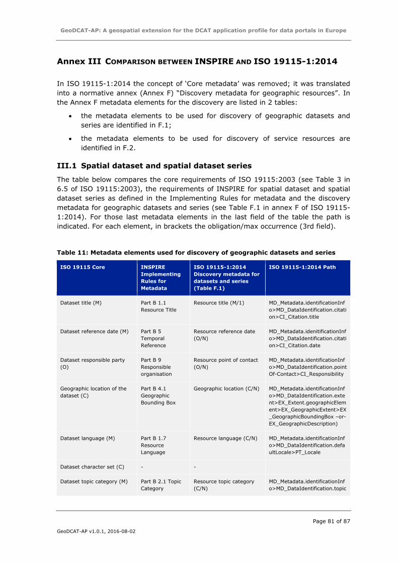
GeoDCAT-AP: A geospatial extension for the DCAT application profile for data portals in Europe
Page 81 of 87
GeoDCAT-AP v1.0.1, 2016-08-02
Annex III COMPARISON BETWEEN INSPIRE AND ISO 19115-1:2014
In ISO 19115-1:2014 the concept of ‘Core metadata’ was removed; it was translated
into a normative annex (Annex F) “Discovery metadata for geographic resources”. In
the Annex F metadata elements for the discovery are listed in 2 tables:
the metadata elements to be used for discovery of geographic datasets and
series are identified in F.1;
the metadata elements to be used for discovery of service resources are
identified in F.2.
III.1 Spatial dataset and spatial dataset series
The table below compares the core requirements of ISO 19115:2003 (see Table 3 in
6.5 of ISO 19115:2003), the requirements of INSPIRE for spatial dataset and spatial
dataset series as defined in the Implementing Rules for metadata and the discovery
metadata for geographic datasets and series (see Table F.1 in annex F of ISO 19115-
1:2014). For those last metadata elements in the last field of the table the path is
indicated. For each element, in brackets the obligation/max occurrence (3rd field).
Table 11: Metadata elements used for discovery of geographic datasets and series
ISO 19115 Core INSPIRE
Implementing
Rules for
Metadata
ISO 19115-1:2014
Discovery metadata for
datasets and series
(Table F.1)
ISO 19115-1:2014 Path
Dataset title (M) Part B 1.1
Resource Title
Resource title (M/1) MD_Metadata.identificationInf
o>MD_DataIdentification.citati
on>CI_Citation.title
Dataset reference date (M) Part B 5
Temporal
Reference
Resource reference date
(O/N)
MD_Metadata.idenitificationInf
o>MD_DataIdentification.citati
on>CI_Citation.date
Dataset responsible party
(O)
Part B 9
Responsible
organisation
Resource point of contact
(O/N)
MD_Metadata.identificationInf
o>MD_DataIdentification.point
Of-Contact>CI_Responsibility
Geographic location of the
dataset (C)
Part B 4.1
Geographic
Bounding Box
Geographic location (C/N) MD_Metadata.identificationInf
o>MD_DataIdentification.exte
nt>EX_Extent.geographicElem
ent>EX_GeographicExtent>EX
_GeographicBoundingBox –or-
EX_GeographicDescription)
Dataset language (M) Part B 1.7
Resource
Language
Resource language (C/N) MD_Metadata.identificationInf
o>MD_DataIdentification.defa
ultLocale>PT_Locale
Dataset character set (C) - -
Dataset topic category (M) Part B 2.1 Topic
Category
Resource topic category
(C/N)
MD_Metadata.identificationInf
o>MD_DataIdentification.topic
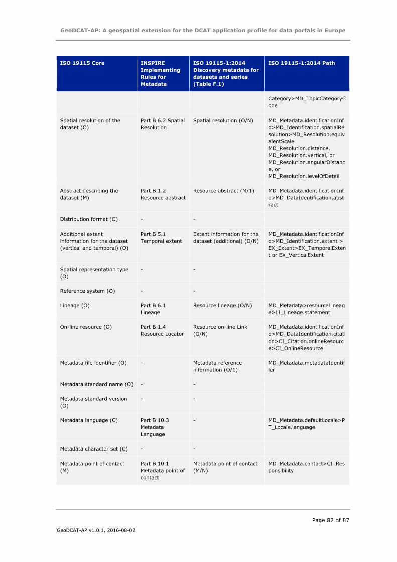
GeoDCAT-AP: A geospatial extension for the DCAT application profile for data portals in Europe
Page 82 of 87
GeoDCAT-AP v1.0.1, 2016-08-02
ISO 19115 Core INSPIRE
Implementing
Rules for
Metadata
ISO 19115-1:2014
Discovery metadata for
datasets and series
(Table F.1)
ISO 19115-1:2014 Path
Category>MD_TopicCategoryC
ode
Spatial resolution of the
dataset (O)
Part B 6.2 Spatial
Resolution
Spatial resolution (O/N) MD_Metadata.identificationInf
o>MD_Identification.spatialRe
solution>MD_Resolution.equiv
alentScale
MD_Resolution.distance,
MD_Resolution.vertical, or
MD_Resolution.angularDistanc
e, or
MD_Resolution.levelOfDetail
Abstract describing the
dataset (M)
Part B 1.2
Resource abstract
Resource abstract (M/1) MD_Metadata.identificationInf
o>MD_DataIdentification.abst
ract
Distribution format (O) - -
Additional extent
information for the dataset
(vertical and temporal) (O)
Part B 5.1
Temporal extent
Extent information for the
dataset (additional) (O/N)
MD_Metadata.identificationInf
o>MD_Identification.extent >
EX_Extent>EX_TemporalExten
t or EX_VerticalExtent
Spatial representation type
(O)
- -
Reference system (O) - -
Lineage (O) Part B 6.1
Lineage
Resource lineage (O/N) MD_Metadata>resourceLineag
e>LI_Lineage.statement
On-line resource (O) Part B 1.4
Resource Locator
Resource on-line Link
(O/N)
MD_Metadata.identificationInf
o>MD_DataIdentification.citati
on>CI_Citation.onlineResourc
e>CI_OnlineResource
Metadata file identifier (O) - Metadata reference
information (O/1)
MD_Metadata.metadataIdentif
ier
Metadata standard name (O) - -
Metadata standard version
(O)
- -
Metadata language (C) Part B 10.3
Metadata
Language
- MD_Metadata.defaultLocale>P
T_Locale.language
Metadata character set (C) - -
Metadata point of contact
(M)
Part B 10.1
Metadata point of
contact
Metadata point of contact
(M/N)
MD_Metadata.contact>CI_Res
ponsibility
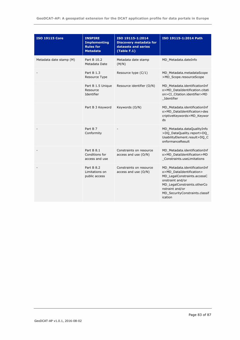
GeoDCAT-AP: A geospatial extension for the DCAT application profile for data portals in Europe
Page 83 of 87
GeoDCAT-AP v1.0.1, 2016-08-02
ISO 19115 Core INSPIRE
Implementing
Rules for
Metadata
ISO 19115-1:2014
Discovery metadata for
datasets and series
(Table F.1)
ISO 19115-1:2014 Path
Metadata date stamp (M) Part B 10.2
Metadata Date
Metadata date stamp
(M/N)
MD_Metadata.dateInfo
- Part B 1.3
Resource Type
Resource type (C/1) MD_Metadata.metadataScope
>MD_Scope.resourceScope
Part B 1.5 Unique
Resource
Identifier
Resource identifier (O/N) MD_Metadata.identificationInf
o>MD_DataIdentification.citati
on>CI_Citation.identifier>MD
_Identifier
Part B 3 Keyword Keywords (O/N) MD_Metadata.identificationInf
o>MD_DataIdentification>des
criptiveKeywords>MD_Keywor
ds
- Part B 7
Conformity
- MD_Metadata.dataQualityInfo
>DQ_DataQuality.report>DQ_
UsabilityElement.result>DQ_C
onformanceResult
- Part B 8.1
Conditions for
access and use
Constraints on resource
access and use (O/N)
MD_Metadata.identificationInf
o>MD_DataIdentification>MD
_Constraints.useLimitations
- Part B 8.2
Limitations on
public access
Constraints on resource
access and use (O/N)
MD_Metadata.identificationInf
o>MD_DataIdentification>
MD_LegalConstraints.accessC
onstraint and/or
MD_LegalConstraints.otherCo
nstraint and/or
MD_SecurityConstraints.classif
ication
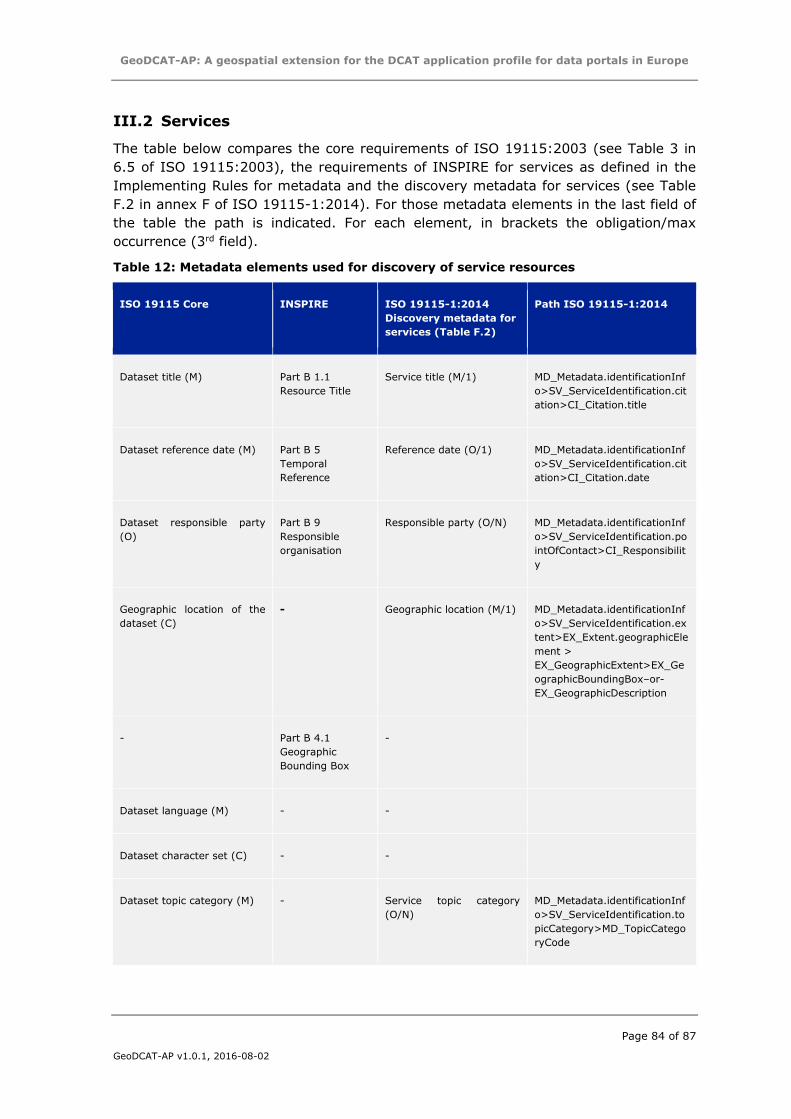
GeoDCAT-AP: A geospatial extension for the DCAT application profile for data portals in Europe
Page 84 of 87
GeoDCAT-AP v1.0.1, 2016-08-02
III.2 Services
The table below compares the core requirements of ISO 19115:2003 (see Table 3 in
6.5 of ISO 19115:2003), the requirements of INSPIRE for services as defined in the
Implementing Rules for metadata and the discovery metadata for services (see Table
F.2 in annex F of ISO 19115-1:2014). For those metadata elements in the last field of
the table the path is indicated. For each element, in brackets the obligation/max
occurrence (3rd field).
Table 12: Metadata elements used for discovery of service resources
ISO 19115 Core INSPIRE ISO 19115-1:2014
Discovery metadata for
services (Table F.2)
Path ISO 19115-1:2014
Dataset title (M) Part B 1.1
Resource Title
Service title (M/1) MD_Metadata.identificationInf
o>SV_ServiceIdentification.cit
ation>CI_Citation.title
Dataset reference date (M) Part B 5
Temporal
Reference
Reference date (O/1) MD_Metadata.identificationInf
o>SV_ServiceIdentification.cit
ation>CI_Citation.date
Dataset responsible party
(O)
Part B 9
Responsible
organisation
Responsible party (O/N) MD_Metadata.identificationInf
o>SV_ServiceIdentification.po
intOfContact>CI_Responsibilit
y
Geographic location of the
dataset (C)
- Geographic location (M/1) MD_Metadata.identificationInf
o>SV_ServiceIdentification.ex
tent>EX_Extent.geographicEle
ment >
EX_GeographicExtent>EX_Ge
ographicBoundingBox–or-
EX_GeographicDescription
- Part B 4.1
Geographic
Bounding Box
-
Dataset language (M) - -
Dataset character set (C) - -
Dataset topic category (M) - Service topic category
(O/N)
MD_Metadata.identificationInf
o>SV_ServiceIdentification.to
picCategory>MD_TopicCatego
ryCode
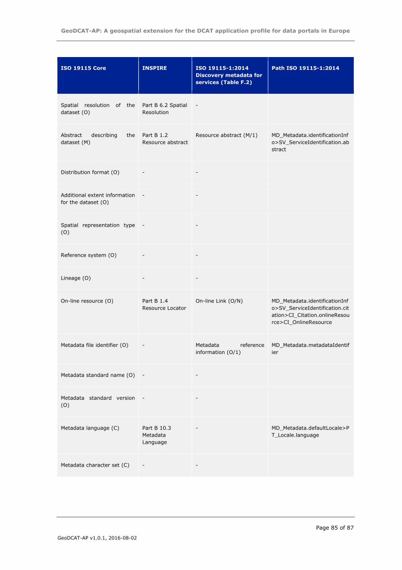
GeoDCAT-AP: A geospatial extension for the DCAT application profile for data portals in Europe
Page 85 of 87
GeoDCAT-AP v1.0.1, 2016-08-02
ISO 19115 Core INSPIRE ISO 19115-1:2014
Discovery metadata for
services (Table F.2)
Path ISO 19115-1:2014
Spatial resolution of the
dataset (O)
Part B 6.2 Spatial
Resolution
-
Abstract describing the
dataset (M)
Part B 1.2
Resource abstract
Resource abstract (M/1) MD_Metadata.identificationInf
o>SV_ServiceIdentification.ab
stract
Distribution format (O) - -
Additional extent information
for the dataset (O)
- -
Spatial representation type
(O)
- -
Reference system (O) - -
Lineage (O) - -
On-line resource (O) Part B 1.4
Resource Locator
On-line Link (O/N) MD_Metadata.identificationInf
o>SV_ServiceIdentification.cit
ation>CI_Citation.onlineResou
rce>CI_OnlineResource
Metadata file identifier (O) - Metadata reference
information (O/1)
MD_Metadata.metadataIdentif
ier
Metadata standard name (O) - -
Metadata standard version
(O)
- -
Metadata language (C) Part B 10.3
Metadata
Language
- MD_Metadata.defaultLocale>P
T_Locale.language
Metadata character set (C) - -
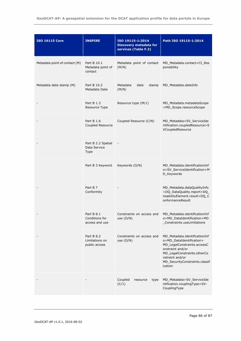
GeoDCAT-AP: A geospatial extension for the DCAT application profile for data portals in Europe
Page 86 of 87
GeoDCAT-AP v1.0.1, 2016-08-02
ISO 19115 Core INSPIRE ISO 19115-1:2014
Discovery metadata for
services (Table F.2)
Path ISO 19115-1:2014
Metadata point of contact (M) Part B 10.1
Metadata point of
contact
Metadata point of contact
(M/N)
MD_Metadata.contact>CI_Res
ponsibility
Metadata date stamp (M) Part B 10.2
Metadata Date
Metadata date stamp
(M/N)
MD_Metadata.dateInfo
- Part B 1.3
Resource Type
Resource type (M/1) MD_Metadata.metadataScope
>MD_Scope.resourceScope
- Part B 1.6
Coupled Resource
Coupled Resource (C/N) MD_Metadata>SV_ServiceIde
ntification.coupledResource>S
VCoupledResource
- Part B 2.2 Spatial
Data Service
Type
-
Part B 3 Keyword Keywords (O/N) MD_Metadata.identificationInf
o>SV_ServiceIdentification>M
D_Keywords
- Part B 7
Conformity
- MD_Metadata.dataQualityInfo
>DQ_DataQuality.report>DQ_
UsabilityElement.result>DQ_C
onformanceResult
- Part B 8.1
Conditions for
access and use
Constraints on access and
use (O/N)
MD_Metadata.identificationInf
o>MD_DataIdentification>MD
_Constraints.useLimitations
- Part B 8.2
Limitations on
public access
Constraints on access and
use (O/N)
MD_Metadata.identificationInf
o>MD_DataIdentification>
MD_LegalConstraints.accessC
onstraint and/or
MD_LegalConstraints.otherCo
nstraint and/or
MD_SecurityConstraints.classif
ication
- - Coupled resource type
(C/1)
MD_Metadata>SV_ServiceIde
ntification.couplingType>SV-
CouplingType
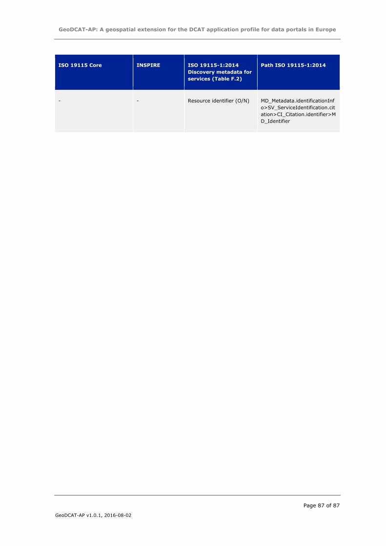
GeoDCAT-AP: A geospatial extension for the DCAT application profile for data portals in Europe
Page 87 of 87
GeoDCAT-AP v1.0.1, 2016-08-02
ISO 19115 Core INSPIRE ISO 19115-1:2014
Discovery metadata for
services (Table F.2)
Path ISO 19115-1:2014
- - Resource identifier (O/N) MD_Metadata.identificationInf
o>SV_ServiceIdentification.cit
ation>CI_Citation.identifier>M
D_Identifier


![GeoDCAT-AP: A geospatial extension for the DCAT ... · metadata elements of the core profile of ISO 19115:2003 [ISO19115] and those defined in the framework of the INSPIRE Directive](https://img.pdfslide.us/doc/110x75/600c09b903bf36255565fd26/geodcat-ap-a-geospatial-extension-for-the-dcat-metadata-elements-of-the-core.jpg)