Embed Size (px)
Citation preview
Geochemical Techniques for Detection of Blind Porphyry Copper-GoldMineralization under Basalt Cover, Woodjam Prospect, South-Central British
Columbia (NTS 093A/03, /06)
T. Bissig, Mineral Deposit Research Unit, University of British Columbia, Vancouver, BC, [email protected]
D.R. Heberlein, Heberlein Geoconsulting, North Vancouver, BC
C.E. Dunn, Colin Dunn Consulting Inc., North Saanich, BC
Bissig, T., Heberlein, D.R., Dunn, C.E. (2013): Geochemical techniques for detection of blind porphyry copper-gold mineralization underbasalt cover, Woodjam prospect, south-central British Columbia (NTS 093A/03, /06); in Geoscience BC Summary of Activities 2012,Geoscience BC, Report 2013-1, p. 63–78.
Introduction
This paper outlines activities conducted under the
Geoscience BC project entitled: “Seeing through Chilcotin
basalts: the geochemical signal of what is hidden under-
neath (092P, 093A, C)”. Field components of the study
were undertaken in conjunction with another Geoscience
BC project in the same area entitled: “Evaluation of plant
exudates to assist in mineral exploration and the develop-
ment of simple and cost effective field procedures and ana-
lytical methods” (see Heberlein et al., 2013).
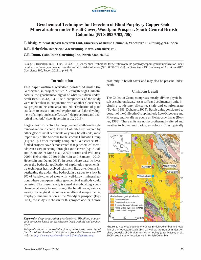
Large areas prospective for porphyry and epithermal-style
mineralization in central British Columbia are covered by
either glaciofluvial sediments or young basalt units, most
importantly of the Miocene to Pleistocene Chilcotin Group
(Figure 1). Other recently completed Geoscience BC-
funded projects have demonstrated that geochemical meth-
ods can assist in seeing through exotic cover (e.g., Cook
and Dunn, 2007; Dunn et al., 2007; Barnett and Williams,
2009; Heberlein, 2010; Heberlein and Samson, 2010;
Heberlein and Dunn, 2011). In areas where basaltic lavas
cover the bedrock, application of exploration-geochemis-
try techniques has received relatively little attention in in-
vestigating the underlying bedrock, in part due to a lack in
BC of basalt-covered sites with well-known mineraliza-
tion, where deep-penetrating geochemical methods could
be tested. The present study is aimed at establishing a geo-
chemical strategy to see through the basalt cover, using a
variety of analytical techniques on different sample media.
Porphyry mineralization at the Woodjam prospect (Fig-
ure 1), the study site chosen for this project, occurs in close
proximity to basalt cover and may also be present under-
neath.
Chilcotin Basalt
The Chilcotin Group comprises mostly olivine-phyric ba-
salt as coherent lavas, lesser tuffs and sedimentary units in-
cluding sandstone, siltstone, shale and conglomerate
(Bevier, 1983; Dohaney, 2009). Basalt units, considered to
be part of the Chilcotin Group, include Late Oligocene and
Miocene, and locally as young as Pleistocene, lavas (Bev-
ier, 1983). These units are not hydrothermally altered and
weather to brown and dark grey colours. They typically
Geoscience BC Report 2013-1 63
Keywords: deep-penetrating geochemistry, Woodjam, copper-gold porphyry, basalt cover, selective leach, soil pH and conduc-tivity
This publication is also available, free of charge, as colour digitalfiles in Adobe Acrobat® PDF format from the Geoscience BCwebsite: http://www.geosciencebc.com/s/DataReleases.asp.
Figure 1. Regional geology of central British Columbia and loca-tion of the Woodjam study area as well as the nearby major por-phyry deposits of Gibraltar and Mount Polley (after Massey et al.,2005); see inset for location within British Columbia.
consist of highly vesiculated coherent lavas, featuring vari-
able degrees of columnar jointing. Chemically, they cover a
broad range of compositions, from alkali olivine-basalt and
basaltic andesite to less common hawaiite, mugearite and
trachyandesite (Dohaney, 2009). Traditionally, Chilcotin
basalt units have been mapped as extensive plateaus (e.g.,
Massey et al., 2005; Figure 1) and are best exposed in the
incised valleys of present-day rivers. Recent work (An-
drews and Russell, 2008; Dohaney, 2009) has established
that most of the basalt lavas actually followed low-lying to-
pography and, in many places where the Chilcotin Group is
mapped, the basalt cover may be thin or absent, making ex-
ploration in those areas potentially viable. Their presence
in the subsurface is commonly indicated by angular boul-
ders and colluvial debris. Chilcotin Group rocks are also
widely covered by Quaternary glacial sediments.
Geochemically the Chilcotin Group basalt units are distinc-
tive from the underlying Triassic Nicola Group basalt flows
and basalt-derived volcaniclastic sediments. In contrast to
the Nicola Group (Vaca, 2012), these units have higher Ti,
Ta, Nb, Th, U and light rare earth element contents, do not
have a clear-cut arc signature, and plot in the tholeiitic and
within-plate fields (Figure 2; Dohaney, 2009). The Nicola
Group and along-strike equivalent Takla Group commonly
host porphyry Cu-Au mineralization, including the Wood-
jam prospect(Figures 1, 3) where the field sampling for this
study was carried out, whereas the Chilcotin Group basalt
units are not known to be mineralized.
Benefits to the Mining Industry
This study is designed to test whether a geochemical signal
of mineralization under basalt cover can be detected in the
near-surface environment. It also aims to provide the min-
eral-exploration community with a better understanding of
different sampling media that can be used for geochemical
exploration in regions with basalt cover. The study pro-
vides comparisons of element concentrations in soils and
plants (spruce) subjected to various total-analysis and se-
lective-leach methods, and assesses the relative capabilities
of each medium for recording the secondary geochemical-
dispersion patterns of the geology, including blind mineral
deposits under cover. It also examines the trace-element
composition of coatings and materials within vesicles in the
basalt units; a selection of results is reported herein.
Project Area
Test sites selected for this study lie within Gold Fields Can-
ada Exploration and Consolidated Woodjam Copper
Corp.’s Woodjam property, which is located in the Cariboo
Mining District of central BC. (NTS map areas 093A/03, /
06; Figure 3). The property, which consists of 178 mineral
claims totalling 58 470 ha, lies about 50 km to the northeast
of Williams Lake. Horsefly, the nearest settlement and lo-
gistical base for the fieldwork, is within the property
boundary and is accessible by a paved road from Williams
Lake.
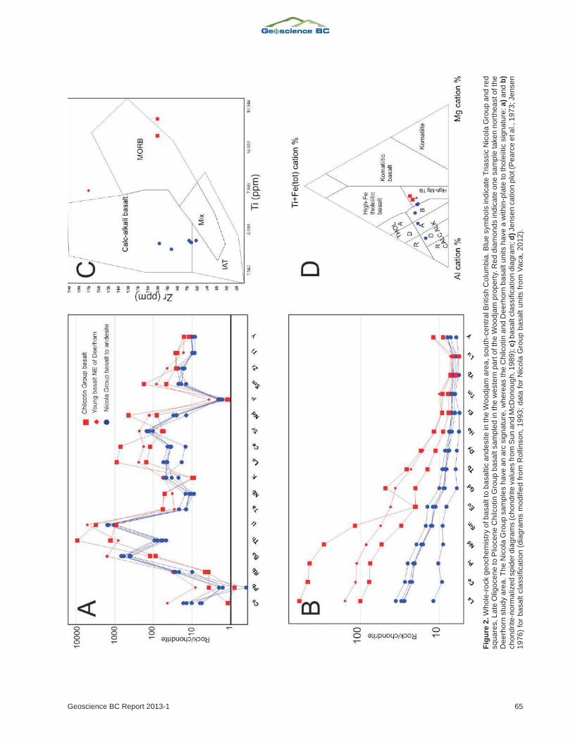
The two test sites, known as Deerhorn and Three Firs (for-
merly known as Megalloy; Figure 3), lie 8 and 12 km re-
spectively to the southeast and south of Horsefly; both are
readily accessible via a network of well-maintained log-
ging roads. Within those areas, one east-oriented and one
east-northeast-oriented sample traverse pass from glacio-
fluvial sediment-covered areas into glaciofluvial sediment-
and/or basalt-covered areas. In both transects, mineraliza-
tion is known to underlie the unconsolidated sediments
near the transition to basalt-covered areas. At the time of
writing, no mineralized zone directly underlying basalt
cover had been defined by drilling, although one (MAG-
12-04) of three angled drillholes (Figure 3; Consolidated
Woodjam Copper Corp., 2012a) at Three Firs passes
through about 60 m of glaciofluvial material and about
30 m of basalt into mineralized bedrock. The top of the bed-
rock, which is fragmental and clay rich, contains Fe and Mn
oxides just below the basalt; this can be interpreted as a
paleoregolith but it may also be interpreted as fault gouge.
Surficial Environment
The project area lies at the boundary between the Fraser
Plateau and Quesnel Highland physiographic regions of
central BC (Holland, 1964). The terrain in the study areas
has characteristics of both regions. The Deerhorn test site
lies at a fairly sharp transition between relatively flat, roll-
ing topography typical of the Fraser Plateau on the western
side of the mineralized zone, and low hills of the Quesnel
Highland to the east (Figure 3). Elevations across the
Deerhorn sample traverses, which cross the transition, vary
from 900 m at the west to 1030 m at the highest point, close
to the eastern end. A number of small lakes and ponds are
dotted throughout the area; the largest of these is Mica lake,
which lies on the southwestern side of the mineralized
zone. Lakes are linked by small streams and boggy depres-
sions, which form part of a dendritic drainage pattern con-
necting with the Horsefly River about 5 km to the northeast
of Deerhorn. Three Firs lies in a similar physiographic set-
ting to Deerhorn (Figure 3). More than half of the Three
Firs sample traverse crosses relatively flat terrain typical of
the Fraser Plateau, where elevations range from 975 to
1000 m asl. At these lower elevations, a number of swamps
and small creeks define a northwest-flowing dendritic
drainage pattern, which merges with Woodjam Creek some
8 km to the northwest. The terrain gradually rises eastward
into the rounded hills of the Quesnel Highland, where the
maximum elevation at the eastern end of the line is 1140 m.
Quaternary glacial deposits cover the mineralization at
both study areas. To the east of Deerhorn, surficial deposits
consist of an intermittent till veneer, which mantles the hill-
64 Geoscience BC Summary of Activities 2012
Geoscience BC Report 2013-1 65
Fig
ure
2.W
ho
le-r
ock
ge
och
em
istr
yo
fb
asa
ltto
ba
sa
ltic
an
de
site
inth
eW
oo
dja
ma
rea
,so
uth
-ce
ntr
alB
ritish
Co
lum
bia
.B
lue
sym
bo
lsin
dic
ate
Tri
assic
Nic
ola
Gro
up
an
dre
dsq
ua
res,L
ate
Olig
oce
ne
toP
lioce
ne
Ch
ilco
tin
Gro
up
ba
sa
ltsa
mp
led
inth
ew
este
rnpa
rto
fth
eW
oo
dja
mp
rop
ert
y.R
ed
dia
mo
nd
sin
dic
ate
on
esa
mp
leta
ke
nn
ort
he
asto
fth
eD
ee
rho
rnstu
dy
are
a.T
he
Nic
ola
Gro
up
sa
mp
les
ha
ve
an
arc
sig
na
ture
,w
he
rea
sth
eC
hilc
otin
an
dD
ee
rho
rnb
asa
ltu
nits
ha
ve
aw
ith
in-p
late
toth
ole
iitic
sig
na
ture
:a
)a
nd
b)
ch
on
dri
te-n
orm
aliz
ed
sp
ide
rd
iag
ram
s(c
ho
nd
rite
va
lue
sfr
om
Su
na
nd
McD
on
ou
gh
,1
98
9);
c)b
asa
ltcla
ssific
atio
nd
iag
ram
;d
)Je
nse
nca
tio
np
lot(P
ea
rce
eta
l.,1
97
3;Je
nse
n1
97
6)
for
ba
sa
ltcla
ssific
atio
n(d
iag
ram
sm
od
ifie
dfr
om
Ro
llin
so
n,
19
93
;d
ata
for
Nic
ola
Gro
up
ba
sa
ltu
nits
fro
mV
aca
,2
01
2).
sides and becomes thicker in topographic depressions. The
maximum thickness of the till is unknown but the presence
of outcrops on the northern flank of the hillside east of
Deerhorn suggests that it is likely to be no more than a few
metres thick at that location. Glacial landforms, such as
drumlinoid features, are present in this area and east of the
sample traverse. Their long axes indicate a west-northwest-
erly ice-flow direction. Cover thickens rapidly westward
onto the lowlands and drilling at Deerhorn has shown that
the bedrock surface is buried beneath up to 60 m of till and
glaciofluvial sediments (Skinner, 2010; Del Real et al.,
2013). Surficial deposits on the eastern shore of Mica lake
and southern limit of the projected mineralized zone (Fig-
ure 3) consist of well-sorted sand and gravel of probable
glaciofluvial origin; the distribution of these deposits is un-
known. A hill consisting of basaltic rocks assigned to the
66 Geoscience BC Summary of Activities 2012
Figure 3. Bedrock geology of the Woodjam South prospect, south-central British Columbia. (modified from Del Real et al., 2013;J. Blackwell, pers. comm., 2012). Map is in UTM NAD 83 projection, Zone 10. Red outlines denote surface projection of the +0.2 g/t Auequivalent mineralization; black dots show soil-sample locations. Specific drillhole and sample locations mentioned in the text are indi-cated. Abbreviations: IAT, island-arc tholeiite; MORB, mid-ocean ridge basalt. Place name with the generic in lower case is unofficial.
Chilcotin Group lies to the east-northeast of the mineral-
ized zone (Figure 3). Samples collected along the east-,
northeast-oriented traverse largely come from this basalt-
covered area. The depth to bedrock below the basalt flows
and potential presence of mineralization below this basalt is
unknown.
At Three Firs, the cover environment contains a Tertiary
basalt unit beneath the glacial deposits in the western part
of the sample traverse. Drilling has indicated that the basalt
may cover a part of the mineralized zone. The basalt con-
sists of a fresh, black, highly vesicular flow unit up to 20 m
thick. Nicola Group rocks at its lower contact are frag-
mented and intensely clay-altered over several metres in
what is either a gouge-filled fault zone or a paleoregolith.
The extent of basalt cover is unknown, although its distri-
bution is most likely restricted to paleovalleys rather than
forming a continuous cap over the mineralized area. This
would be typical of other occurrences of Chilcotin Group
flows in the region (Dohaney, 2009). Surficial deposits at
Three Firs consist predominantly of glacial till, which
forms a blanket 40–100 m thick. There is no outcrop in the
vicinity of the mineralization. Till cover appears to thin
gradually eastward and outcrops of a distinctive ‘turkey-
track’ feldspar porphyritic andesite become widespread in
the east-central part of the sample traverse. On the hillside,
at the eastern end of the traverse, till cover is present as a
thin veneer of no more than a metre or two thick.
Regional Geological Setting
The Woodjam prospect lies in the southern part of the
highly prospective Quesnel terrane: a Late Triassic to Early
Jurassic magmatic arc complex, which extends for most of
the length of the Canadian Cordillera. It is flanked to the
east by assemblages of Proterozoic and Paleozoic carbon-
ate and siliciclastic rocks of ancestral North American af-
finity, but is separated from them by a sliver of oceanic ba-
salt and chert of the Slide Mountain terrane (Schiarizza et
al., 2009). Oceanic rocks of the Late Paleozoic to Early Me-
sozoic Cache Creek terrane bound the Quesnel terrane to
the west. The southern part of the Quesnel terrane hosts a
number of important Cu-Au porphyry deposits; nearby
examples include Gibraltar and Mount Polley.
In the Woodjam area, the Quesnel terrane is represented by
Middle to Upper Triassic volcano-sedimentary rocks of the
Nicola Group (Figures 1, 3). Locally, this consists of a shal-
low northwest-dipping sequence of volcanic and volcanic-
derived sedimentary rocks, which include augite-phyric
basalt flows and polymictic breccias containing latite,
trachyte and equivalent volcanic clasts (Gold Fields Can-
ada Exploration, unpublished data, 2012). Sandstone and
conglomerate are intercalated with the volcanic units. A
suite of more or less coeval intrusions of alkaline to calcal-
kaline affinity intrudes the volcanic and sedimentary se-
quence. These intrusions include the Early Jurassic Takom-
kane batholith, located to the south and east of the project
area, and a number of smaller syenite, monzonite, quartz
monzonite and monzodiorite stocks and dikes within the
Woodjam property itself, many of which are associated
with Cu-Au mineralization.
The Woodjam South property contains several centres of
Early Jurassic porphyry-style Cu-Mo-Au mineralization
(Schiarizza, 2009; Sherlock et al., 2012; Mineral Deposit
Research Unit, unpublished data, 2011). Style of mineral-
ization, hostrocks and metal association vary from one min-
eralized centre to another; these include the Southeast,
Takom, Megabuck, Deerhorn and Three Firs zones (Fig-
ure 3; Del Real et al., 2013). The Southeast zone is at the
most advanced stage of exploration and is currently under-
going advanced exploration drilling. Copper-molybdenum
mineralization is hosted in intrusive rocks, which form part
of the Takomkane batholith. Deerhorn is the next most ad-
vanced prospect and is currently at the advanced explora-
tion drilling stage. It is characterized by Cu-Au mineraliza-
tion hosted in Nicola Group volcanic rocks and a series of
small porphyry stocks and dikes (see below). The remain-
ing prospects are all at the exploratory drilling stage. Three
Firs represents a new discovery that was made early in 2012
(Consolidated Woodjam Copper Corp., 2012a); it is cur-
rently in the initial drill-testing stage. Nicola Group rocks
in much of the western part of the Woodjam South property
area and an area to the east of Deerhorn are covered by
younger Cenozoic basalt flows belonging to the Chilcotin
Group. This younger volcanic- and sedimentary-rock cov-
er masks prospective areas of the underlying Nicola Group.
Geology of Test Areas
Deerhorn
Deerhorn is a blind zone of porphyry Cu-Au–style mineral-
ization, which was discovered by drilling a large
chargeability anomaly in 2007 (Skinner, 2010). The miner-
alization, defined by the red +0.2 g/t Au equivalent outline
in Figure 3, is the surface projection of a pipe-like body
containing a higher-grade shoot, which plunges at a moder-
ate angle to the southeast (Gold Fields Canada Exploration,
unpublished data, 2012). Its dimensions are approximately
350 m in strike, 100 m in width and 200 m in depth (Consol-
idated Woodjam Copper Corp., 2012b). Higher-grade min-
eralization is enclosed within a much more extensive
lower-grade envelope defined by quartz and magnetite
stockwork and veinlets, and disseminated chalcopyrite
mineralization. Low-grade mineralization is coincident
with an arcuate chargeability anomaly, which extends
northwest of the Deerhorn drill site and continues south and
west to the Megabuck East and Megabuck prospects.
Geological mapping and reconstruction of the bedrock ge-
ology from drilling by Gold Fields Canada Exploration
Geoscience BC Report 2013-1 67
(Figure 3; J. Blackwell, pers. comm., 2012) indicate that the
mineralization is hosted in a southwest-striking, northwest-
dipping package of Nicola Group andesite and volcanic-
derived sandstone. Higher-grade mineralization is associ-
ated with a number of northwest-striking dike-like
monzonite bodies, which cross the contact between volca-
nic-derived sandstone in the southeast and andesite in the
northwest of the mineralized zone. The intrusion and vol-
cano-sedimentary units are offset by sets of west-north-
west- and northeast-striking faults (Gold Fields Canada
Exploration, unpublished data, 2012). Mineralization
subcrops beneath a variable cover of Quaternary glacial
and glaciofluvial deposits, which consist of a till blanket up
to 40 m thick over the mineralization and a sequence of
overlying glaciofluvial sand and gravel exposed in road-
cuts near the southeastern shore of Mica lake; the extent of
these deposits is unknown. To the northeast of the mineral-
ized area, coherent basalt flows, presumably of the Chil-
cotin Group, are present. The thickness of these basalts is
unknown but they appear to be directly underlying the soil
profile in at least part of the area.
Three Firs (Megalloy)
Bedrock geology of the Three Firs study area is not well un-
derstood. Mineralization was only discovered at this pros-
pect during the spring of 2012 and, at the time of sampling
for this study, only three holes had encountered significant
Cu-Au mineralization (Consolidated Woodjam Copper
Corporation, 2012a). What makes this study area appealing
from a deep-penetrating–geochemistry standpoint is the
presence of a basalt unit, inferred to be part of the Chilcotin
Group, which overlies at least part of the mineralized zone.
The extent of the basalt is unknown and difficult to resolve
from the interpretation of ground and airborne magnetic
data (Gold Fields Canada Exploration, unpublished data,
2012). Drilling shows that it consists of one or several co-
herent flows and forms a cap at least 30 m thick overlying
the altered and mineralized Nicola Group rocks. The
known distribution of basalt and the surface projections of
the mineralized drill intersections are illustrated in Figure 3
(Gold Fields Canada Exploration, unpublished data, 2012)
and indicated for reference in the geochemical plots below.
Overlying the basalt are Quaternary glacial sediments;
where observed in drill road exposures, these appear to
consist of a boulder till containing abundant large rounded
clasts (up to 1 m in diameter) of distinctive ‘turkey-track’
andesite porphyry that is known to outcrop near the eastern
end of the sample traverse and immediately to the south-
east. The size and composition of the boulders indicate that
the till is locally derived and possibly forms only a thin
veneer across the survey area.
Field Procedures
Soils
At each sample station, at least one hole was dug to a depth
of about 50 cm to collect a few grams of the upper Ae hori-
zon (eluviated greyish zone immediately below the or-
ganic-rich Ah horizon) for pH and conductivity measure-
ments, the upper B horizon (Bf or Bm horizon) and the
interval of 10–25 cm beneath the base of organic matter for
Mobile Metal Ion™ (MMI) analysis. The locations of the
sample stations are shown on Figure 3 and the sample types
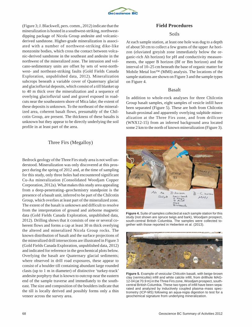
on Figure 4.
Basalt
In addition to whole-rock analyses for three Chilcotin
Group basalt samples, eight samples of vesicle infill have
been separated (Figure 5). These are both from Chilcotin
basalt-proximal and apparently overlying sulphide miner-
alization at the Three Firs zone, and from drillcore
(WNX12-15) from an inferred background area located
some 2 km to the north of known mineralization (Figure 3).
68 Geoscience BC Summary of Activities 2012
Figure 4. Suite of samples collected at each sample station for thisstudy (not shown are spruce twigs and bark), Woodjam prospect,south-central British Columbia. The samples were collected to-gether with those reported in Heberlein et al. (2013).
Figure 5. Example of vesicular Chilcotin basalt, with beige-brownclay (vermiculite) infill and white calcite infill, from drillhole MAG-12-04 (at 70.9 m) in the Three Firs zone, Woodjam prospect, south-central British Columbia. These two types of infill have been sepa-rated and analyzed by inductively coupled plasma–mass spec-trometry (ICP-MS) following an aqua-regia digestion to test for ageochemical signature from underlying mineralization.
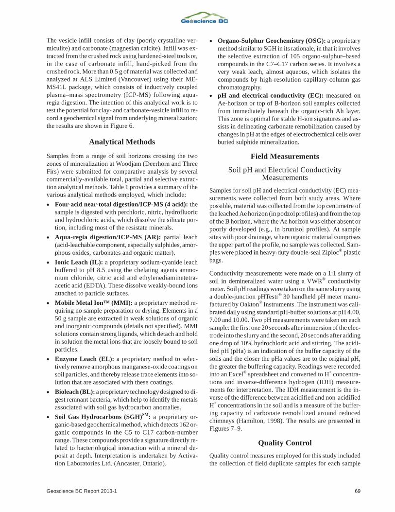
The vesicle infill consists of clay (poorly crystalline ver-
miculite) and carbonate (magnesian calcite). Infill was ex-
tracted from the crushed rock using hardened-steel tools or,
in the case of carbonate infill, hand-picked from the
crushed rock. More than 0.5 g of material was collected and
analyzed at ALS Limited (Vancouver) using their ME-
MS41L package, which consists of inductively coupled
plasma–mass spectrometry (ICP-MS) following aqua-
regia digestion. The intention of this analytical work is to
test the potential for clay- and carbonate-vesicle infill to re-
cord a geochemical signal from underlying mineralization;
the results are shown in Figure 6.
Analytical Methods
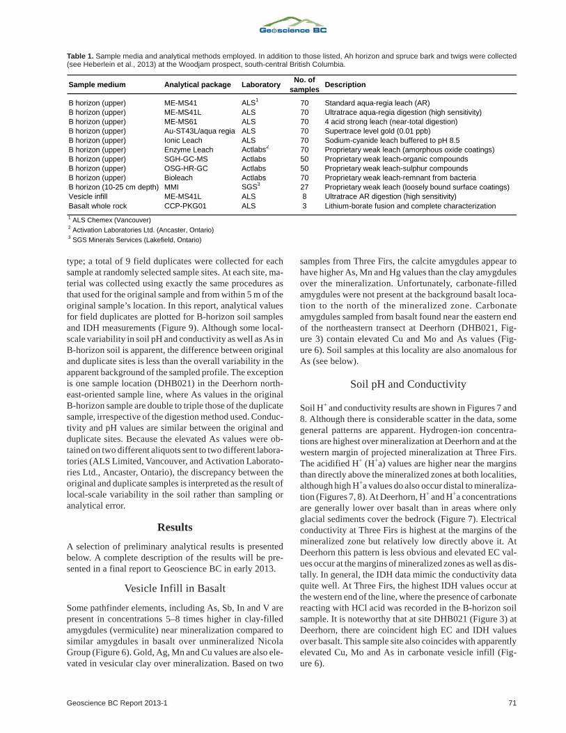
Samples from a range of soil horizons crossing the two
zones of mineralization at Woodjam (Deerhorn and Three
Firs) were submitted for comparative analysis by several
commercially-available total, partial and selective extrac-
tion analytical methods. Table 1 provides a summary of the
various analytical methods employed, which include:
� Four-acid near-total digestion/ICP-MS (4 acid): the
sample is digested with perchloric, nitric, hydrofluoric
and hydrochloric acids, which dissolve the silicate por-
tion, including most of the resistate minerals.
� Aqua-regia digestion/ICP-MS (AR): partial leach
(acid-leachable component, especially sulphides, amor-
phous oxides, carbonates and organic matter).
� Ionic Leach (IL): a proprietary sodium-cyanide leach
buffered to pH 8.5 using the chelating agents ammo-
nium chloride, citric acid and ethylenediaminetetra-
acetic acid (EDTA). These dissolve weakly-bound ions
attached to particle surfaces.
� Mobile Metal Ion™ (MMI): a proprietary method re-
quiring no sample preparation or drying. Elements in a
50 g sample are extracted in weak solutions of organic
and inorganic compounds (details not specified). MMI
solutions contain strong ligands, which detach and hold
in solution the metal ions that are loosely bound to soil
particles.
� Enzyme Leach (EL): a proprietary method to selec-
tively remove amorphous manganese-oxide coatings on
soil particles, and thereby release trace elements into so-
lution that are associated with these coatings.
� Bioleach (BL): a proprietary technology designed to di-
gest remnant bacteria, which help to identify the metals
associated with soil gas hydrocarbon anomalies.
� Soil Gas Hydrocarbons (SGH)SM
: a proprietary or-
ganic-based geochemical method, which detects 162 or-
ganic compounds in the C5 to C17 carbon-number
range. These compounds provide a signature directly re-
lated to bacteriological interaction with a mineral de-
posit at depth. Interpretation is undertaken by Activa-
tion Laboratories Ltd. (Ancaster, Ontario).
� Organo-Sulphur Geochemistry (OSG): a proprietary
method similar to SGH in its rationale, in that it involves
the selective extraction of 105 organo-sulphur–based
compounds in the C7–C17 carbon series. It involves a
very weak leach, almost aqueous, which isolates the
compounds by high-resolution capillary-column gas
chromatography.
� pH and electrical conductivity (EC): measured on
Ae-horizon or top of B-horizon soil samples collected
from immediately beneath the organic-rich Ah layer.
This zone is optimal for stable H-ion signatures and as-
sists in delineating carbonate remobilization caused by
changes in pH at the edges of electrochemical cells over
buried sulphide mineralization.
Field Measurements
Soil pH and Electrical ConductivityMeasurements
Samples for soil pH and electrical conductivity (EC) mea-
surements were collected from both study areas. Where
possible, material was collected from the top centimetre of
the leached Ae horizon (in podzol profiles) and from the top
of the B horizon, where the Ae horizon was either absent or
poorly developed (e.g., in brunisol profiles). At sample
sites with poor drainage, where organic material comprises
the upper part of the profile, no sample was collected. Sam-
ples were placed in heavy-duty double-seal Ziploc® plastic
bags.
Conductivity measurements were made on a 1:1 slurry of
soil in demineralized water using a VWR® conductivity
meter. Soil pH readings were taken on the same slurry using
a double-junction pHTestr® 30 handheld pH meter manu-
factured by Oakton® Instruments. The instrument was cali-
brated daily using standard pH-buffer solutions at pH 4.00,
7.00 and 10.00. Two pH measurements were taken on each
sample: the first one 20 seconds after immersion of the elec-
trode into the slurry and the second, 20 seconds after adding
one drop of 10% hydrochloric acid and stirring. The acidi-
fied pH (pHa) is an indication of the buffer capacity of the
soils and the closer the pHa values are to the original pH,
the greater the buffering capacity. Readings were recorded
into an Excel® spreadsheet and converted to H+ concentra-
tions and inverse-difference hydrogen (IDH) measure-
ments for interpretation. The IDH measurement is the in-
verse of the difference between acidified and non-acidified
H+ concentrations in the soil and is a measure of the buffer-
ing capacity of carbonate remobilized around reduced
chimneys (Hamilton, 1998). The results are presented in
Figures 7–9.
Quality Control
Quality control measures employed for this study included
the collection of field duplicate samples for each sample
Geoscience BC Report 2013-1 69
70 Geoscience BC Summary of Activities 2012
Fig
ure
6C
he
mis
try
(aq
ua
reg
ia)
ofve
sic
lein
fill
inC
hilc
otin
ba
sa
lt,W
oo
dja
mp
rosp
ect,
so
uth
-ce
ntr
alB
ritish
Co
lum
bia
.T
he
x-a
xis
on
the
pro
ba
bili
typ
lots
sh
ow
sth
en
orm
alsco
rein
un
its
of
sta
nd
ard
de
via
tio
nfo
r:a
)A
u;
b)
Ag
;c
)A
s;
d)
V;
e)
Cu
;f)
Hg
;g
)In
;h
)M
n;
i)M
o;
j)S
b.
An
aly
tica
lva
lue
sa
reg
ive
nin
pa
rts
pe
rm
illio
n(p
pm
).
type; a total of 9 field duplicates were collected for each
sample at randomly selected sample sites. At each site, ma-
terial was collected using exactly the same procedures as
that used for the original sample and from within 5 m of the
original sample’s location. In this report, analytical values
for field duplicates are plotted for B-horizon soil samples
and IDH measurements (Figure 9). Although some local-
scale variability in soil pH and conductivity as well as As in
B-horizon soil is apparent, the difference between original
and duplicate sites is less than the overall variability in the
apparent background of the sampled profile. The exception
is one sample location (DHB021) in the Deerhorn north-
east-oriented sample line, where As values in the original
B-horizon sample are double to triple those of the duplicate
sample, irrespective of the digestion method used. Conduc-
tivity and pH values are similar between the original and
duplicate sites. Because the elevated As values were ob-
tained on two different aliquots sent to two different labora-
tories (ALS Limited, Vancouver, and Activation Laborato-
ries Ltd., Ancaster, Ontario), the discrepancy between the
original and duplicate samples is interpreted as the result of
local-scale variability in the soil rather than sampling or
analytical error.
Results
A selection of preliminary analytical results is presented
below. A complete description of the results will be pre-
sented in a final report to Geoscience BC in early 2013.
Vesicle Infill in Basalt
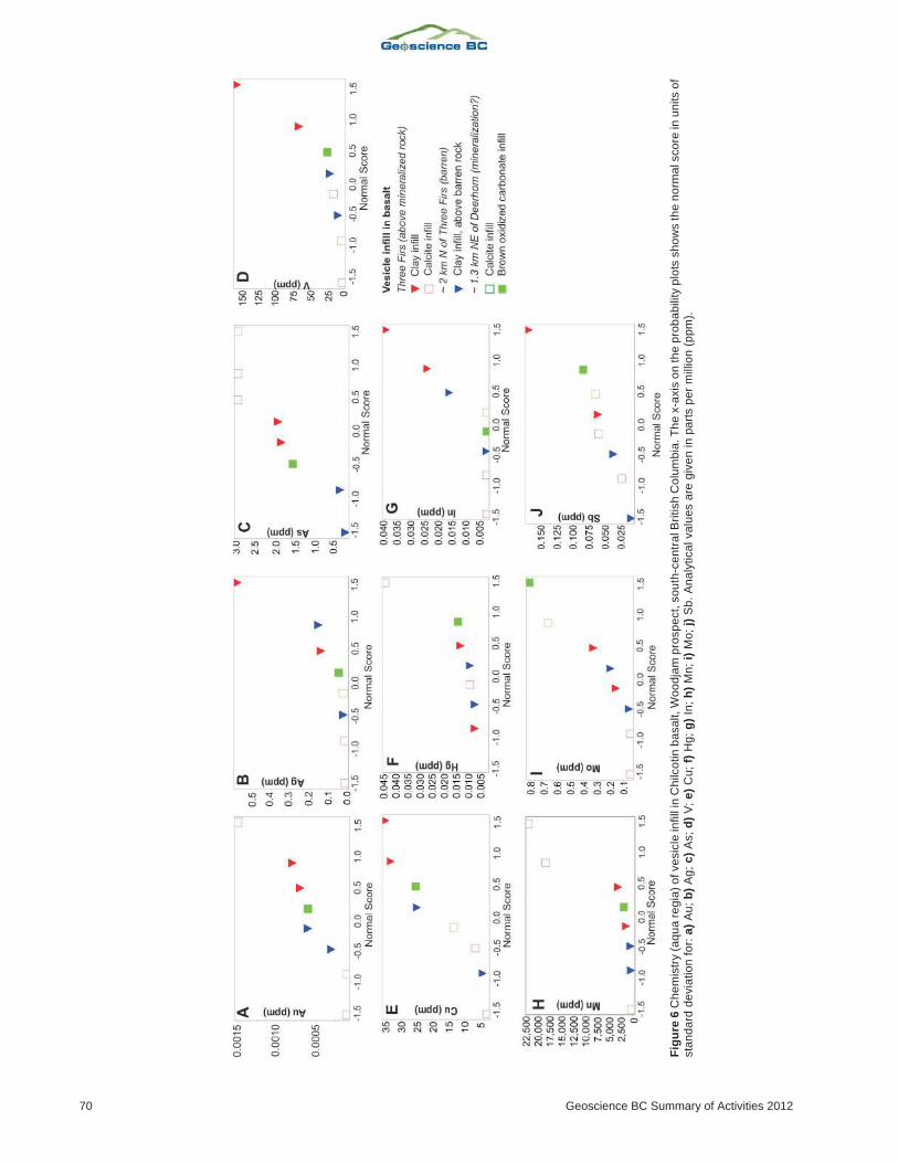
Some pathfinder elements, including As, Sb, In and V are
present in concentrations 5–8 times higher in clay-filled
amygdules (vermiculite) near mineralization compared to
similar amygdules in basalt over unmineralized Nicola
Group (Figure 6). Gold, Ag, Mn and Cu values are also ele-
vated in vesicular clay over mineralization. Based on two
samples from Three Firs, the calcite amygdules appear to
have higher As, Mn and Hg values than the clay amygdules
over the mineralization. Unfortunately, carbonate-filled
amygdules were not present at the background basalt loca-
tion to the north of the mineralized zone. Carbonate
amygdules sampled from basalt found near the eastern end
of the northeastern transect at Deerhorn (DHB021, Fig-
ure 3) contain elevated Cu and Mo and As values (Fig-
ure 6). Soil samples at this locality are also anomalous for
As (see below).
Soil pH and Conductivity
Soil H+ and conductivity results are shown in Figures 7 and
8. Although there is considerable scatter in the data, some
general patterns are apparent. Hydrogen-ion concentra-
tions are highest over mineralization at Deerhorn and at the
western margin of projected mineralization at Three Firs.
The acidified H+ (H+a) values are higher near the margins
than directly above the mineralized zones at both localities,
although high H+a values do also occur distal to mineraliza-
tion (Figures 7, 8). At Deerhorn, H+ and H+a concentrations
are generally lower over basalt than in areas where only
glacial sediments cover the bedrock (Figure 7). Electrical
conductivity at Three Firs is highest at the margins of the
mineralized zone but relatively low directly above it. At
Deerhorn this pattern is less obvious and elevated EC val-
ues occur at the margins of mineralized zones as well as dis-
tally. In general, the IDH data mimic the conductivity data
quite well. At Three Firs, the highest IDH values occur at
the western end of the line, where the presence of carbonate
reacting with HCl acid was recorded in the B-horizon soil
sample. It is noteworthy that at site DHB021 (Figure 3) at
Deerhorn, there are coincident high EC and IDH values
over basalt. This sample site also coincides with apparently
elevated Cu, Mo and As in carbonate vesicle infill (Fig-
ure 6).
Geoscience BC Report 2013-1 71
Sample medium Analytical package LaboratoryNo. of
samplesDescription
B horizon (upper) ME-MS41 ALS1
70 Standard aqua-regia leach (AR)
B horizon (upper) ME-MS41L ALS 70 Ultratrace aqua-regia digestion (high sensitivity)
B horizon (upper) ME-MS61 ALS 70 4 acid strong leach (near-total digestion)
B horizon (upper) Au-ST43L/aqua regia ALS 70 Supertrace level gold (0.01 ppb)
B horizon (upper) Ionic Leach ALS 70 Sodium-cyanide leach buffered to pH 8.5
B horizon (upper) Enzyme Leach Actlabs2
70 Proprietary weak leach (amorphous oxide coatings)
B horizon (upper) SGH-GC-MS Actlabs 50 Proprietary weak leach-organic compounds
B horizon (upper) OSG-HR-GC Actlabs 50 Proprietary weak leach-sulphur compounds
B horizon (upper) Bioleach Actlabs 70 Proprietary weak leach-remnant from bacteria
B horizon (10-25 cm depth) MMI SGS3
27 Proprietary weak leach (loosely bound surface coatings)
Vesicle infill ME-MS41L ALS 8 Ultratrace AR digestion (high sensitivity)
Basalt whole rock CCP-PKG01 ALS 3 Lithium-borate fusion and complete characterization
1ALS Chemex (Vancouver)
2Activation Laboratories Ltd. (Ancaster, Ontario)
3SGS Minerals Services (Lakefield, Ontario)
Table 1. Sample media and analytical methods employed. In addition to those listed, Ah horizon and spruce bark and twigs were collected(see Heberlein et al., 2013) at the Woodjam prospect, south-central British Columbia.

72 Geoscience BC Summary of Activities 2012
Fig
ure
7.S
oil
pH
an
dco
nd
uctivity
da
tafo
rth
eD
ee
rho
rnsu
rve
ya
rea
,Wo
od
jam
pro
sp
ect,
so
uth
-ce
ntr
alB
ritish
Co
lum
bia
.Are
as
un
de
rb
asa
ltco
ve
ra
nd
su
rfa
ce
pro
jectio
no
fth
em
ine
raliz
atio
n,
de
fin
ed
by
the
0.2
g/t
Au
eq
uiv
ale
ntco
nto
urs
,a
rere
pre
se
nte
db
yg
rap
hs
sh
ow
ing
a)H
+,co
nce
ntr
atio
no
fh
yd
rog
en
ion
s(~
inve
rse
ofp
H);
b)H
+a
,co
nce
ntr
atio
no
fh
yd
rog
en
ion
sa
fte
ra
dd
itio
no
f1
dro
po
f1
0%
HC
la
cid
;c
)e
lectr
ica
lco
nd
uctivity;
d)
inve
rse
hyd
rog
en
diffe
ren
ce
,1
/(H
+a
–H
+).
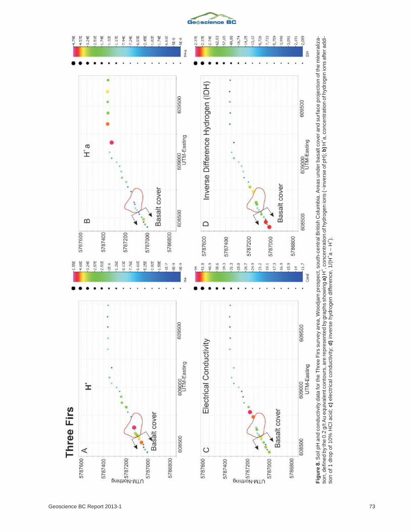
Geoscience BC Report 2013-1 73
Fig
ure
8.S
oil
pH
an
dco
nd
uctivity
da
tafo
rth
eT
hre
eF
irs
su
rve
ya
rea
,W
oo
dja
mp
rosp
ect,
so
uth
-ce
ntr
alB
ritish
Co
lum
bia
.A
rea
su
nd
erb
asa
ltco
ve
ra
nd
su
rfa
ce
pro
jectio
no
fth
em
ine
raliz
a-
tio
n,d
efin
ed
by
the
0.2
g/t
Au
eq
uiv
ale
ntc
on
tou
rs,a
rere
pre
se
nte
db
yg
rap
hs
sh
ow
ing
a)H
+,c
on
ce
ntr
atio
no
fhyd
rog
en
ion
s(~
inve
rse
ofp
H);
b)H
+a
,co
nce
ntr
atio
no
fhyd
rog
en
ion
sa
fte
ra
dd
i-tio
no
f1
dro
po
f1
0%
HC
la
cid
;c
)e
lectr
ica
lco
nd
uctivity;
d)
inve
rse
hyd
rog
en
diffe
ren
ce
,1
/(H
+a
–H
+).
74 Geoscience BC Summary of Activities 2012
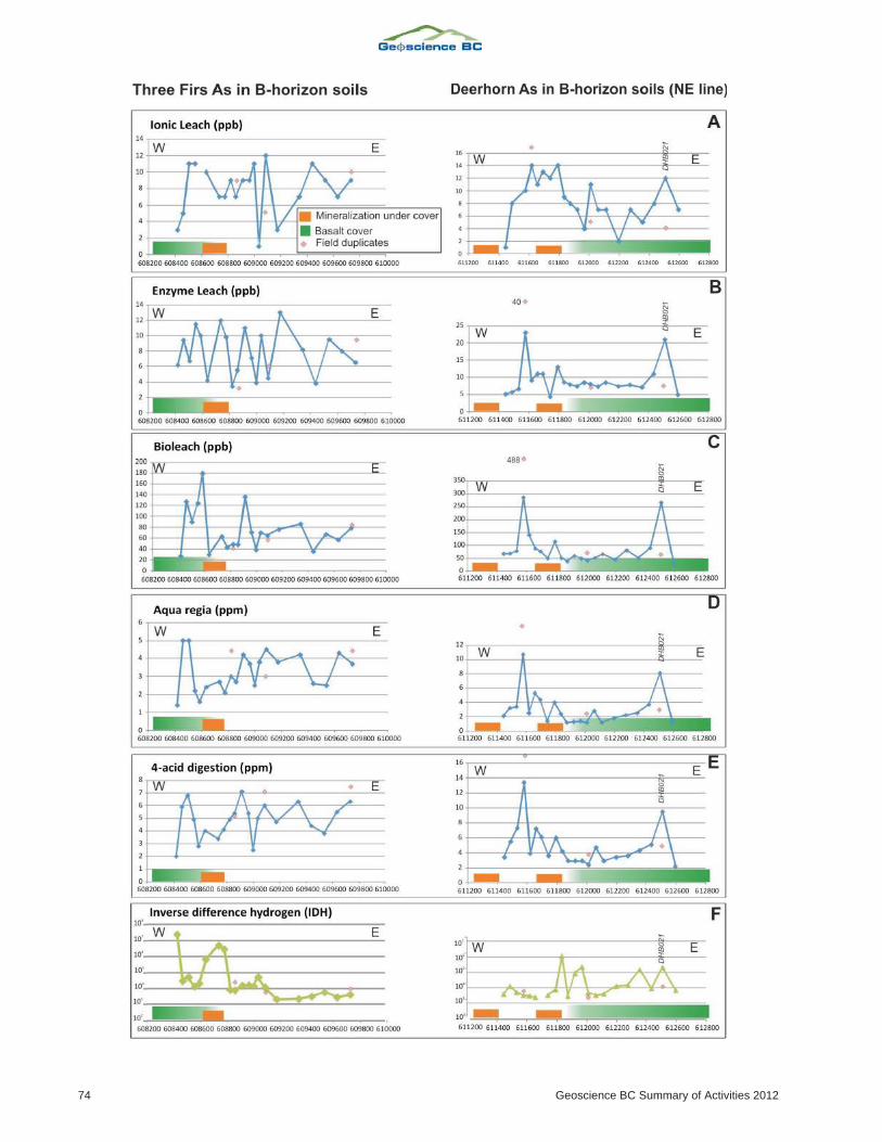
B-Horizon Soil Geochemistry
For the purposes of this paper, As results were chosen to il-
lustrate the variations in response between the different an-
alytical techniques over the partly basalt-covered areas at
Three Firs and the northeast-oriented sample traverse at
Deerhorn (Figure 9). Arsenic is a common pathfinder ele-
ment used in porphyry exploration and accumulates at re-
dox gradients, such as above the edge of mineralization
(Hamilton, 1998; Pfeifer et al., 2004). It was chosen be-
cause elevated concentrations of it were also observed in
amygdules in basalt (Figure 6). At Three Firs, elevated As
values occurring in the vicinity of the mineralized zone are
most clearly observed in the results obtained from the
Bioleach and aqua-regia digestions. Arsenic values at the
edges of the mineralized zone are double to triple the values
of soils directly above the mineralization. Enzyme Leach
and Ionic Leach results are noisy and do not show any rec-
ognizable pattern. The response from the 4-acid digestion
does seem to mimic the aqua-regia results but the data are of
lower contrast near the mineralization. It is noteworthy that
the westernmost 4 to 5 samples at Three Firs were collected
where basalt is inferred to underlie the glaciofluvial sedi-
ments. The results of the Bioleach and aqua-regia diges-
tions reveal that several of these samples contain elevated
As (Figure 9). The IDH results are also shown on Figure 9
for comparison. The samples directly above mineralization
are about three orders of magnitude lower than on either
margin, although the highest value at the western extreme
of the sampled line does not coincide with elevated As
values in the aqua-regia and Bioleach data.
On the Deerhorn northeastern sample traverse, As concen-
trations are highest between the two mineralized areas (or-
ange bars on Figure 9). Slightly elevated As values are also
evident in the eastern part of the mineralized area, near the
location at which the basalt cover is inferred to start. As
seen at Three Firs, the aqua-regia and Bioleach results
show 2–4 fold increases in As concentrations between the
mineralized zones compared to soils directly above miner-
alization. However, in contrast to Three Firs, Enzyme
Leach and 4-acid digestions also show similar patterns;
Ionic Leach lacks a recognizable signal for this element.
The second sample from the eastern end of the Deerhorn
traverse (site DHB021) also exhibits consistently high As
concentrations in all extractions, which coincides with a
relatively high IDH value (approximately 2 x 10⁵) and high
As concentrations in carbonate-vesicle infill (Figures 6, 7).
Implications for Exploration Geochemistryin Basalt-Covered Areas
Preliminary data analysis suggests that soils directly over
basalt-covered areas (i.e., northeast of Deerhorn) have
some inherent geochemical characteristics, such as lower
H+ (or elevated pH), that distinguish them from areas only
covered by glaciofluvial sediments. This may be explained
by the more reactive nature of the relatively mafic Chilcotin
Group basalt units compared to the underlying Nicola
Group. The high IDH and conductivity values at Three Firs,
and less clearly at Deerhorn, may be related to remobilized
carbonate at the margins of a possible reduced chimney
above mineralization. The IDH response does not appear to
be distinct between basalt-covered areas and those that are
only covered by glaciofluvial sediment. The analytical re-
sults also suggest that the geochemical signal of As can be
seen through both types of cover. This is exemplified at
Three Firs, where elevated As was detected in soils above
basalt cover adjacent to known mineralization.
Both at Deerhorn and Three Firs, the Bioleach and aqua-
regia techniques provide good contrast results. Preliminary
comparison with SGH and OSG data, and interpretations
provided by Activation Laboratories Ltd. (Sutherland,
2012), suggest a positive anomaly of low molecular-weight
SGH and sulphur allotrope coincident with high As values.
At Deerhorn, near the eastern limit of the sample traverse,
there are coincident IDH, conductivity and soil As re-
sponses. All methods, except Ionic Leach, define an inter-
pretable pattern. It is unknown to what extent these re-
sponses indicate the presence of underlying mineralization
because of the poor precision provided by the field dupli-
cate samples. However, this response cannot be explained
as a result of hydromorphic concentration because the sam-
ple location does not coincide with a break in slope or
poorly drained ground. One possible explanation is that soil
anomalies may be influenced by the fracture permeability
in the basalt cover. Further sampling is necessary to delin-
eate the small-scale soil geochemical variability and
potential significance of this feature.
Although the dataset is limited, results from clay and car-
bonate amygdules in the basalt suggest that this sample me-
dium may be capable of recording a signal from mineraliza-
tion under basalt cover. Mobile ions from the underlying
mineralization are perhaps being captured by adsorption
onto clay, whereas in carbonate some of the elements pres-
ent in comparatively high concentrations may form part of
the calcite-crystal structure (e.g., Mn, Cu). These may re-
flect the immediate wallrock composition or elements mo-
bilized from below. In the samples studied here, carbonate
amygdules have only been encountered where nearby min-
Geoscience BC Report 2013-1 75
Figure 9. Comparison of As geochemistry using different methodson B-horizon soils taken in partly basalt-covered east-northeast-oriented transects (see Figure 3 for locations), Woodjam prospect,south-central British Columbia. The left column is for the Three Firsarea, the right column for the Deerhorn area. The results for differ-ent methods are presented, from weak digestion at the top tostrong digestion at the bottom: a) Ionic Leach; b) Enzyme Leach; c)Bioleach; d) aqua regia; e) 4 acid; f) inverse-difference–hydrogen(IDH) data are shown for comparison. Pink diamonds depict the an-alytical values for the field duplicates.
eralization is known or where soils are anomalous in As.
Therefore, it can, be hypothesized that vesicle-filling car-
bonate could be an indication of pH gradients that occur at
the margins of reduced chimneys above oxidizing
sulphides (cf. Hamilton, 1998). Clearly, further study and
more extensive sampling are necessary to confirm the
potential use of vesicle and/or fracture infill as a geochemi-
cal-exploration tool.
Acknowledgments
The authors thank Gold Fields Canada Exploration and
Consolidated Woodjam Copper Corp. for allowing them
access to the Woodjam property and for providing them
with much of the base-map data included in this report.
They also appreciate their generous logistical support dur-
ing the sampling campaigns. A special thank you to
R. Sherlock and A. Rainbow for their advice during the
planning stages of the project and to A. Annejohn and
M. Eckfeldt for their assistance with the sampling. They
also acknowledge Activation Laboratories Ltd. and ALS
Limited for their generous contributions to the analytical
work, and C. Hart and J. Blackwell for their reviews and
helpful suggestions for improvements to the manuscript.
Finally, the authors thank Geoscience BC for its financial
support, without which this project would not have been
possible.
References
Andrews, G.D.M. and Russell, J.K. (2008): Cover thickness acrossthe southern Interior Plateau, British Columbia (NTS 092O,P; 093A, B, C, F): constraints from water-well records;Geoscience BC Summary of Activities 2007, GeoscienceBC, Report 2008-1, p. 11–20.
Barnett, C.T. and Williams, P.M. (2009): Using geochemistry andneural networks to map geology under glacial cover;Geoscience BC, Report 2009-3, 27 p., URL <http://www.geosciencebc.com/s/2009-03.asp> [November 2012].
Bevier, M. L. (1983) Regional stratigraphy and age of ChilcotinGroup basalts, south-central British Columbia: CanadianJournal of Earth Sciences, v. 20, no. 4, p. 515–524.
Consolidated Woodjam Copper Corp. (2012a): New gold-copperzone discovered at the Woodjam North property; Consoli-dated Woodjam Copper Corp., press release, August 7,2012, URL <http://www.woodjamcopper.com/2012/ 08/07/gold-copper-zone-discovered-woodjam-north-property/>[November 2012].
Consolidated Woodjam Copper Corp. (2012b): Woodjam North;Consolidated Woodjam Copper Corp., URL <http://www.woodjamcopper.com/projects/woodjam-north/> [No-vember 2012].
Cook, S.J. and Dunn, C.E. (2007): Final report on results of theCordilleran Geochemistry Project: a comparative assess-ment of soil geochemical methods for detecting buried min-eral deposits—3Ts Au-Ag prospect, central BritishColumbia; Geoscience BC, Report 2007-7, 225 p., URL<http://www.geosciencebc.com/s/2007-07.asp> [Novem-ber 2012].
del Real, I., Hart, C.J.R., Bouzari, F., Blackwell, J.L., Rainbow, A.,Sherlock, R. and Skinner, T. (2012): Paragenesis and alter-ation of the Southeast Zone and Deerhorn porphyry depos-its, Woodjam property, central British Columbia (parts of093A); in Geoscience BC Summary of Activities 2012,Geoscience BC, Report 2013-1, p. 79–90.
Dohaney, J. A.M. (2009): Distribution of the Chilcotin Group bas-alts, British Columbia; MSc thesis, University of British Co-lumbia, 124 p., 2 maps, URL <https://circle.ubc.ca/ handle/2429/24161> [November 2012].
Dunn, C.E., Cook, S.J. and Hall, G.E.M. (2007): Halogens in sur-face exploration geochemistry: evaluation and developmentof methods for detecting buried mineral deposits;Geoscience BC, Report 2007-10, URL <http://www.geosciencebc.com/s/2007-10.asp> [November 2012].
Hamilton, S.M. (1998): Electrochemical mass-transport in over-burden: a new model to account for the formation of selec-tive leach geochemical anomalies in glacial terrain; Journalof Geochemical Exploration, v 63, p. 155–172.
Heberlein, D.R. (2010): Comparative study of partial and selectiveextractions of soils over blind porphyry copper-gold miner-alization at Kwanika and Mount Milligan, central BritishColumbia (NTS 093N/01, /19): fieldwork, soil conductivityand pH results; in Geoscience BC Summary of Activities2010, Geoscience BC, Report 2010-1, p. 11–24., URL <http://www.geosciencebc.com/s/SummaryofActivi t ies .asp?ReportID=379075> [November 2012].
Heberlein, D.R. and Dunn, C.E. (2011): The application of surfaceorganic materials as sample media over deeply buried min-eralization at the Kwanika Central Zone, north-central Brit-ish Columbia (NTS 93N); Geoscience BC, Report 2011-3,p. 1–74., URL <http://www.geosciencebc.com/s/2011-03.asp> [November 2012].
Heberlein, D. R. and Samson, H. (2010): An assessment of soilgeochemical methods for detecting copper-gold porphyrymineralization through Quaternary glaciofluvial sedimentsat the Kwanika Central Zone, north-central British Colum-bia; Geoscience BC, Report 2010-3, p. 1–89., URL <http://www.geosciencebc.com/s/2010-03.asp> [November 2012].
Heberlein, D.R., Dunn, C.E. and Macfarlane, W. (2013): Use of or-ganic media in the geochemical detection of blind porphyrycopper-gold mineralization in the Woodjam property area,south-central British Columbia (NTS 093A/03, /06); inGeoscience BC Summary of Activities 2012, GeoscienceBC, Report 2013-1, p. 47–62.
Holland, S.S. (1964): Landforms of British Columbia: a physio-graphic outline; BC Ministry of Energy, Mines and NaturalGas, Bulletin 48, 138 p.
Jensen, L.S. (1976): A new cation plot for classifying subalkalicvolcanic rocks; Ontario Division of Mines, MiscellaneousPaper, no. 66.
Massey, N.W.D, MacIntyre, D.G., Desjardins, P.J. and Cooney,R.T. (2005): Digital geology map of British Columbia:whole province; BC Ministry of Energy, Mines and NaturalGas, GeoFile 2005-1, URL <http://www.empr.gov.bc.ca/Mining/Geoscience/PublicationsCatalogue/GeoFiles/Pages/2005-1.aspx> [November 2012].
Pearce, J.A. and Cann, J.R. (1973): Tectonic setting of basic volca-nic rocks determined using trace element analyses; Earthand Planetary Science Letters, v. 19, p. 290–230.
Pfeifer, H.-R., Gueye-Girardet, A., Reymond, D., Schlegel, C.,Temgoua, E., Hesterberg, D. L. and Chou, J. W. (2004): Dis-persion of natural arsenic in the Malcantone watershed,
76 Geoscience BC Summary of Activities 2012
southern Switzerland: field evidence for repeated sorption-desorption and oxidation-reduction processes; Geoderma,v. 122, p. 205–234.
Rollinson, H. (1993): Using geochemical data: evaluation, presen-tation, interpretation; Longman, 177 p.
Schiarizza, P., Bell, K. and Bayliss, S. (2009): Geology and min-eral occurrences of the Murphy Lake area, south-centralBritish Columbia (NTS 093A/03); in Geological Fieldwork2008, BC Ministry of Energy, Mines and Natural Gas, Paper2009-1, p. 169–187.
Sherlock, R., Poos, S., Trueman, A. (2012): NI 43-101 Technicalreport for 2011 activities on the Woodjam South property;Consolidated Woodjam Copper Corp., 185 p., URL <http://woodjamcopper.com/data/NI%2043-101%20Woodjam%20Technical%20Report.pdf> [November, 2012]
Skinner, T. (2010): Report on the 2010 activities on the WoodjamNorth Property; BC Ministry of Energy, Mines and Natural
Gas, Assessment Report 32 302, 81 p., URL <http://aris.empr.gov.bc.ca/search.asp?mode=repsum&rep_no=32302> [November 2012].
Sun, S.-s. and McDonough, W. F. (1989): Chemical and isotopicsystematics of oceanic basalts: implications for mantle com-positions and processes; in Magmatism in the Ocean Basins,A.D. Saunders and M.J. Norry (ed.), Geological Society ofAmerica, Special Publication 42, p. 313–345.
Sutherland, D. (2012): SGH-soil gas hydrocarbon predictive geo-chemistry; prepared for the Mineral Deposit Research Unit,Department of Earth and Ocean Sciences, University ofBritish Columbia, unpublished report, 42 p.
Vaca, S. (2012): Variability in the Nicola/Takla Group basalts andimplications for alkalic Cu-Au porphyry prospectivity in theQuesnel terrane, British Columbia, Canada; MSc thesis,University of British Columbia, Vancouver, 148 p., URL<https://circle.ubc.ca/handle/2429/43192> [November2012].
Geoscience BC Report 2013-1 77

78 Geoscience BC Summary of Activities 2012