Embed Size (px)
Citation preview
Geo Technical Investigation Report for Bhakrywala Landfill Site
Geo technical Investigation and Topographic Survey for Landfill Site in Gujranwala
Geotechnical Investigation Report
The report presents findings of the field investigation laboratory testing and geotechnical recommendations for Geo technical Investigation and Topographic Survey for Landfill Site in Gujranwala.
[January 20154]

Geo Technical Investigation Report for Bhakrywala Landfill Site
Title Page
Executive Summary 1
1. Introduction 2
1.1. Scope of Report 2
1.2. Objectives of Investigations 2
1.3. Proposed Development 2
1.4. Scope of Work 2 1.4.1. Field Investigations 2 1.4.2. Laboratory Tests 3
2. Site Description 4
2.1. Location of the Project Site 4
2.2. Geology and Seismicity of the Area 4 2.2.1. Geology 4 2.2.2. Seismicity 4
2.3. Current Use of Project Area 4
2.4. Topography of Project Area 4
3. Subsurface Exploration 5
3.1. General 5
3.2. Drilling 5
3.3. Standard Penetration Tests (SPT) 5
3.4. Sampling 5 3.4.1. Disturbed Soil Samples 5 3.4.2. Undisturbed Soil Samples 6 3.4.3. Ground Water Samples 6
3.5. Installation of Piezometers 6
3.6. Field Permeability Test 7
4. Laboratory Test Results 8
4.1. Grain Size Analysis 8
4.2. Hydrometer Analysis 8
4.3. Atterberg Limits 9
Table of Contents

Geo Technical Investigation Report for Bhakrywala Landfill Site
4.4. Natural Moisture Content 9
4.5. Direct Shear Test 9
4.6. Unconfined Compressive Strength 10
4.7. Oedometer Test (OED) 10
4.8. Chemical Tests 10
5. Ground Conditions and Engineering Properties 11
5.1. Lithology of Project Area 11
5.2. Ground Conditions 11
5.3. Groundwater Table 12
5.4. Geotechnical Design Parameters 12 5.4.1. Summary of Design Parameters 12 5.4.2. Discussion on Design Parameters 12 5.4.3. Geotechnical Design Criteria 12
6. Engineering Considerations 14
6.1. Earthworks 14 6.1.1. Ground Preparation 14
6.2. Foundations 14 6.2.1. Proposed Structures 14 6.2.2. Design of Shallow Foundations 14 6.2.3. Modulus of Subgrade Reaction 14 6.2.4. Placement of Granular Fill 15
6.3. Lateral Earth Pressure 15 6.3.1. Static Earth Pressure Coefficients 15 6.3.2. Dynamic Earth Pressure Coefficients 16
6.4. Construction of Roads & Embankments 16 6.4.1. Formation of Subgrade and Embankment 16 6.4.2. Borrow Placement and Compaction 16
6.5. Constraints and Risks 17 6.5.1. Damp Proofing and Surface Drainage 17 6.5.2. Contaminated Land 17 6.5.3. Quality Control 17
6.6. Design and Construction Aspects of Land Fill 17 6.6.1. Formation of Temporary and Final Cover 17 6.6.2. Excavation at Site 18 6.6.3. Liquefaction Potential 18 6.6.4. Cement Type 18
7. Conclusions 19
8. References 20
Annexure A. Drawings A-1
A.1. Site Location Map A-2

Geo Technical Investigation Report for Bhakrywala Landfill Site
A.2. Geotechnical Investigation Plan A-1
A.3. Geological Map of the Project Area A-1
A.4. Seismic Map of Pakistan A-1
Annexure B. Figures B-1
B.1. Variation of SPT Blows with Depth B-2
B.2. Summary of Laboratory Test Results B-4 B.2.1. Laboratory Classification Testing B-5 B.2.2. Summary of Strength Related Test Results B-1
B.3. Allowable Bearing Capacity Curve B-1 B.3.1. Square/Rectangular Foundation B-1 B.3.2. Strip Foundation B-1
Annexure C. Field Permeability Test Data C-1
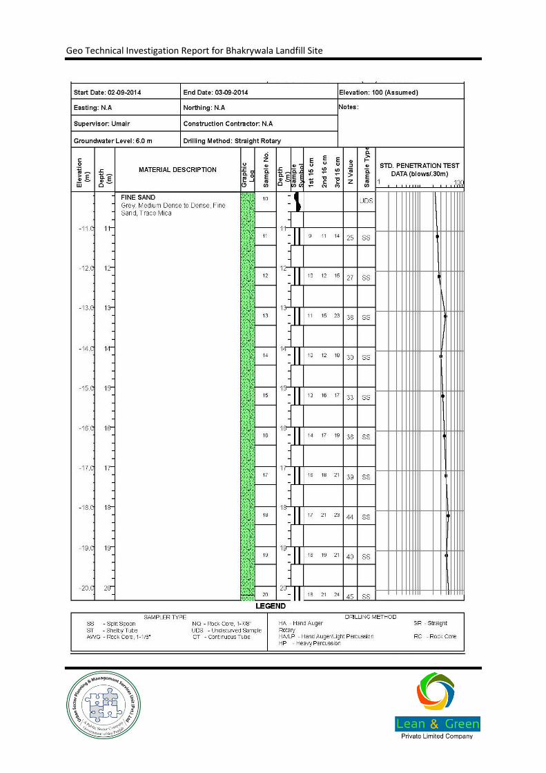
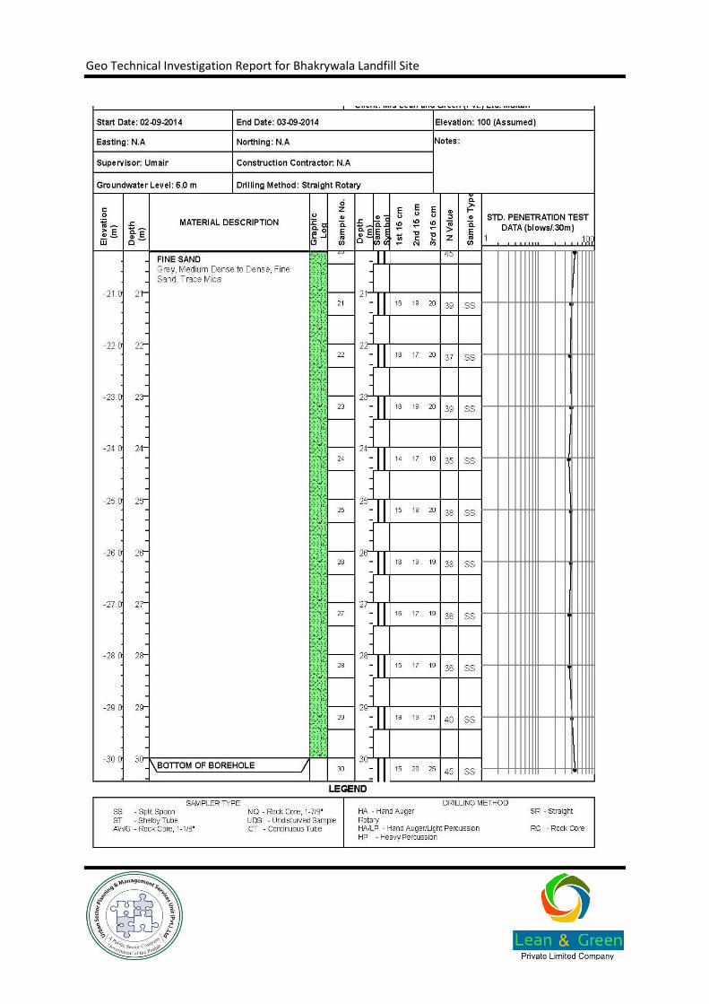
Annexure D. Site Investigation Logs D-7
D.1. Borehole Logs D-8
Annexure E. Laboratory Test Data Error! Bookmark not defined.
Annexure F. Site Photographs E-1
Geo Technical Investigation Report for Bhakrywala Landfill Site
List of Tables
Table 1-1: List of Field Tests 3
Table 1-2: List of Laboratory Tests 3
Table 3-1 - Ground Water Level Observation during Field Investigation 6
Table 5-1: Summary of Ground Conditions 11
Table 5-2: Summary of Design Parameters 12
Table 6-1: Borrow Compaction Parameters 16
Geo Technical Investigation Report for Bhakrywala Landfill Site
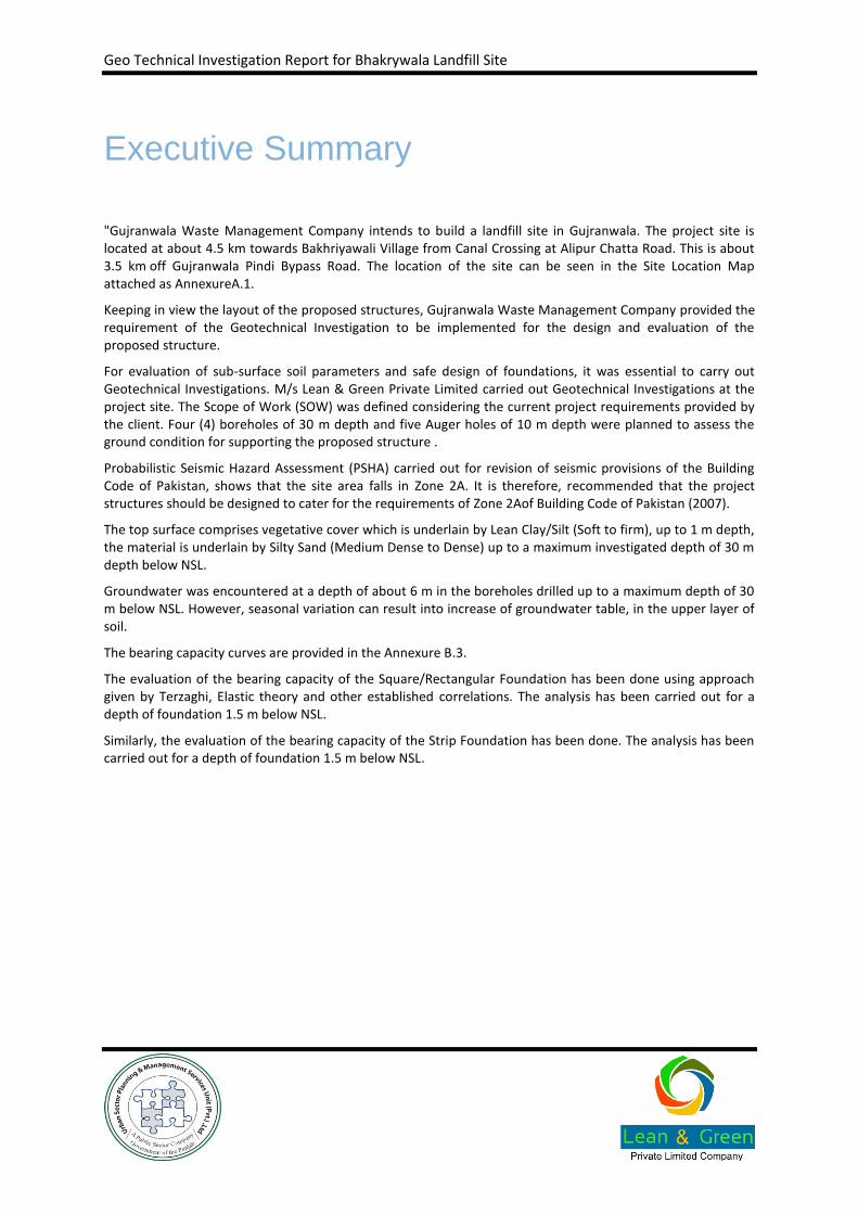
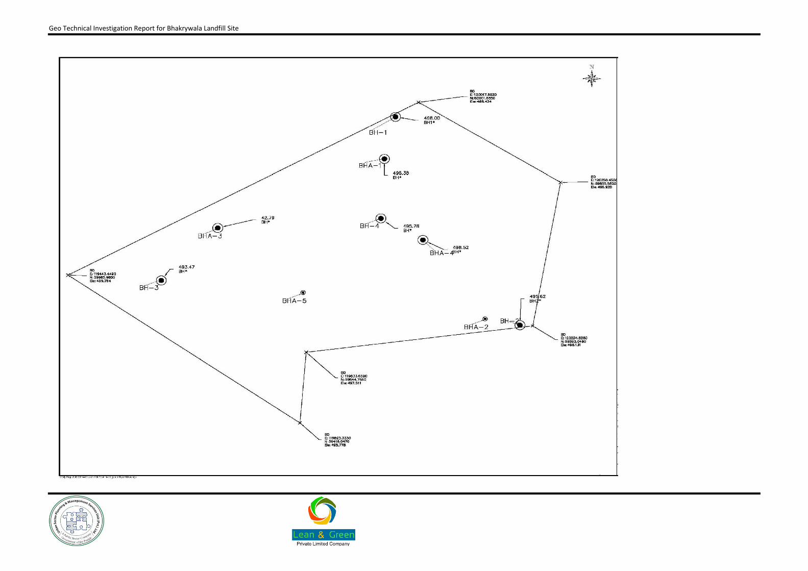
"Gujranwala Waste Management Company intends to build a landfill site in Gujranwala. The project site is located at about 4.5 km towards Bakhriyawali Village from Canal Crossing at Alipur Chatta Road. This is about 3.5 km off Gujranwala Pindi Bypass Road. The location of the site can be seen in the Site Location Map attached as AnnexureA.1.
Keeping in view the layout of the proposed structures, Gujranwala Waste Management Company provided the requirement of the Geotechnical Investigation to be implemented for the design and evaluation of the proposed structure.
For evaluation of sub-surface soil parameters and safe design of foundations, it was essential to carry out Geotechnical Investigations. M/s Lean & Green Private Limited carried out Geotechnical Investigations at the project site. The Scope of Work (SOW) was defined considering the current project requirements provided by the client. Four (4) boreholes of 30 m depth and five Auger holes of 10 m depth were planned to assess the ground condition for supporting the proposed structure .
Probabilistic Seismic Hazard Assessment (PSHA) carried out for revision of seismic provisions of the Building Code of Pakistan, shows that the site area falls in Zone 2A. It is therefore, recommended that the project structures should be designed to cater for the requirements of Zone 2Aof Building Code of Pakistan (2007).
The top surface comprises vegetative cover which is underlain by Lean Clay/Silt (Soft to firm), up to 1 m depth, the material is underlain by Silty Sand (Medium Dense to Dense) up to a maximum investigated depth of 30 m depth below NSL.
Groundwater was encountered at a depth of about 6 m in the boreholes drilled up to a maximum depth of 30 m below NSL. However, seasonal variation can result into increase of groundwater table, in the upper layer of soil.
The bearing capacity curves are provided in the Annexure B.3.
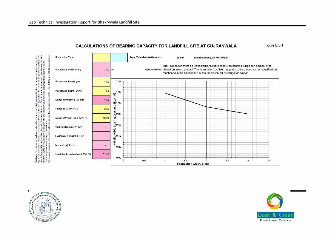
The evaluation of the bearing capacity of the Square/Rectangular Foundation has been done using approach given by Terzaghi, Elastic theory and other established correlations. The analysis has been carried out for a depth of foundation 1.5 m below NSL.
Similarly, the evaluation of the bearing capacity of the Strip Foundation has been done. The analysis has been carried out for a depth of foundation 1.5 m below NSL.
Executive Summary

Geo Technical Investigation Report for Bhakrywala Landfill Site
1.1. Scope of Report
Gujranwala Waste Management Company (GWMC) has planned the construction of a Landfill Site in Gujranwala. The project site is located at about 4.5 km towards Bakhriyawali Village from Canal Crossing at Alipur Chatta Road, this is about 3.5 km off Gujranwala Pindi Bypass Road. Keeping in view the layout of the proposed structures GWMC provided the requirement of the Geotechnical Investigation to be implemented for the design and evaluation of the proposed structure.
For evaluation of sub-surface soil parameters and safe design of foundations, it was essential to carry out Geotechnical Investigations. M/s Lean & Green Private Limited was assigned the task to carry out Geotechnical Investigations at the project site. This Geotechnical Investigation report provides detail of current site conditions and interpretation of the investigation works carried out for the design and evaluation of proposed foundations. In addition, the report also delineates the guidelines and recommendations on geotechnical aspects to be used for structural design as well as considerations for construction activity.
1.2. Objectives of Investigations
The geotechnical investigation were undertaken to meet the following objectives:
To delineate the subsoil conditions of the site area.
To evaluate the geotechnical design parameters for various structures
1.3. Proposed Development
The proposed project involves Construction of Landfill Site in Gujranwala.
1.4. Scope of Work
The Scope of Work (SOW) was defined considering the current project requirements provided by the client. The Geotechnical Investigation was accordingly planned to assess the ground condition for supporting the proposed structure.
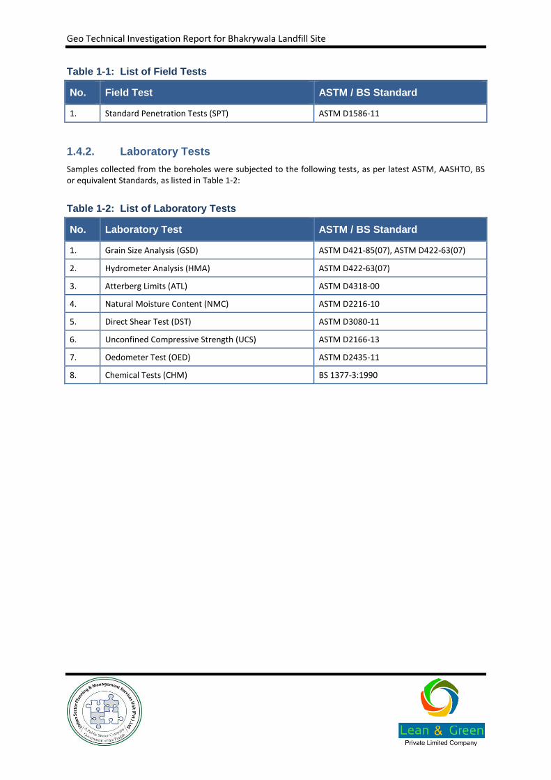
1.4.1. Field Investigations
The Scope of Work (SOW) was defined considering the current project requirements provided by the client. Four (4) boreholes of 30m depth and five Auger holes of 10 m depth were planned to assess the ground condition for supporting the proposed structure.
In addition to above three of the boreholes were converted in to piezometers, for long term monitoring of fluctuation of ground water table. Five (5) permeability tests were performed in the auger holes drilled at site up to maximum investigation depth of 10 m below NSL. The field investigations were performed as per the latest ASTM standards listed in Table 1-1
1. Introduction
Geo Technical Investigation Report for Bhakrywala Landfill Site
Table 1-1: List of Field Tests
No. Field Test ASTM / BS Standard
1. Standard Penetration Tests (SPT) ASTM D1586-11
1.4.2. Laboratory Tests
Samples collected from the boreholes were subjected to the following tests, as per latest ASTM, AASHTO, BS or equivalent Standards, as listed in Table 1-2:
Table 1-2: List of Laboratory Tests
No. Laboratory Test ASTM / BS Standard
1. Grain Size Analysis (GSD) ASTM D421-85(07), ASTM D422-63(07)
2. Hydrometer Analysis (HMA) ASTM D422-63(07)
3. Atterberg Limits (ATL) ASTM D4318-00
4. Natural Moisture Content (NMC) ASTM D2216-10
5. Direct Shear Test (DST) ASTM D3080-11
6. Unconfined Compressive Strength (UCS) ASTM D2166-13
7. Oedometer Test (OED) ASTM D2435-11
8. Chemical Tests (CHM) BS 1377-3:1990
Geo Technical Investigation Report for Bhakrywala Landfill Site
2.1. Location of the Project Site
The project site is located at about 4.5 km towards Bakhriyawali Village from Canal Crossing at Alipur Chatta Road, this is about 3.5 km off Gujranwala Pindi Bypass Road. The location of the site can be seen in the Site Location Map attached as AnnexureA.1
2.2. Geology and Seismicity of the Area
2.2.1. Geology
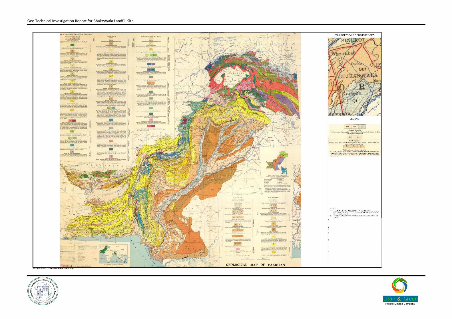
The project site is located in Punjab, which is a plain of Alluvial material and scattered rocks at deeper depth. A Geological Map showing the Geological distribution of the area is provided in Annexure A.3Geological Map of the Project Area.
2.2.2. Seismicity
Probabilistic Seismic Hazard Assessment (PSHA) carried out for revision of seismic provisions of the Building Code of Pakistan, shows that the site area falls in Zone 2A. It is therefore, recommended that the project structures should be designed to cater for the requirements of Zone 2Aof Building Code of Pakistan (2007).
A plan showing various zones of Pakistan as per Latest Seismic Microzonation as given in the Building code of Pakistan is attached with this report as Annexure A.4.
2.3. Current Use of Project Area
The site area is currently open, and partly in use as agriculture and mostly for borrowing the material for nearby earth works.
2.4. Topography of Project Area
The topographically the site area used to be a fairly plain. But after start of borrowing of soil, it has developed depressions of more than 6 m in the most of area which is now filled with water. The area under cultivation is fairly plain.
2. Site Description
Geo Technical Investigation Report for Bhakrywala Landfill Site
3.1. General
The field investigation was performed under full time supervision by our experienced geotechnical engineer who supervised drilling operation, sampling and logging and top supervised the laboratory testing. The field tests that were performed are listed in Table 1-1
3.2. Drilling
A total of nine (9) boreholes of maximum borehole depth of thirty meters (30 m) were planned at the project site. The field investigation was supported by relevant laboratory testing. The drilling and sampling work has been performed using the standards, procedures and equipment’s recommended for engineering site investigation. The exact location of boreholes has been marked on the ground in the presence of the client’s representative.
3.3. Standard Penetration Tests (SPT)
Standard penetration test is by far the most popular and economical method of obtaining subsurface information. It is carried out to assess the in-situ compactness of various soil layers. Significant numbers of foundation design procedures make use of SPT results.
Testing method essentially consists of driving split spoon sampler of specified dimensions up to a distance of 46cm into the soil at bottom of borehole. A 63.5kg hammer failing free from a height of 76cm is used to drive the sampler. Number of blows required to drive the sampler were carried out in accordance with the specification of ASTM D1586-11. Continuous standard penetration test is performed wherever possible.
The SPT’s were carried out at an interval of 1m in boreholes. A total of one hundred sixteen (116) SPT’s were performed. Annexure B.1 shows the variation of SPT blows with depth and the detail of SPT Results are given in the individual borehole logs in Annexure D.1.
3.4. Sampling
Collection of representative samples forms an essential part of investigation program. The following types of samples have been collected for this Project.
3.4.1. Disturbed Soil Samples
Disturbed soil samples were obtained either from the Auger/bailer as the borehole was advanced or from the spilt spoon sampler after performing Standard Penetration Test (SPT). Disturbed samples were used to classify the soil type and depth of occurrence of different layers, and were preserved, for laboratory testing. All the samples obtained from the boreholes were properly preserved in polythene bags and labelled as disturbed samples. The entire sampling, preservation and transportation of the samples were carried out as per latest ASTM standards.
3. Subsurface Exploration
Geo Technical Investigation Report for Bhakrywala Landfill Site
3.4.2. Undisturbed Soil Samples
A total of four (4) undisturbed soil samples were recovered from the boreholes, using Pitcher samplers. After determining the in-situ density, the samples were properly waxed, labelled and preserved before transportation to the laboratory.
3.4.3. Ground Water Samples
The groundwater table was encountered at a depth of about 6m below NSL, during geotechnical investigations carried out at site. A total of four (4) water sample were collected from the boreholes.
The most of the exiting site area has been ponded apparently with the ground water and rain water accumulated in the deep excavated area more than 6 m.
3.5. Installation of Piezometers
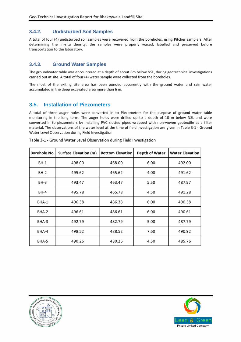
A total of three auger holes were converted in to Piezometers for the purpose of ground water table monitoring in the long term. The auger holes were drilled up to a depth of 10 m below NSL and were converted in to piezometers by installing PVC slotted pipes wrapped with non-woven geotextile as a filter material. The observations of the water level at the time of field investigation are given in Table 3-1 - Ground Water Level Observation during Field Investigation
Table 3-1 - Ground Water Level Observation during Field Investigation
Borehole No. Surface Elevation (m) Bottom Elevation Depth of Water Water Elevation
BH-1 498.00 468.00 6.00 492.00
BH-2 495.62 465.62 4.00 491.62
BH-3 493.47 463.47 5.50 487.97
BH-4 495.78 465.78 4.50 491.28
BHA-1 496.38 486.38 6.00 490.38
BHA-2 496.61 486.61 6.00 490.61
BHA-3 492.79 482.79 5.00 487.79
BHA-4 498.52 488.52 7.60 490.92
BHA-5 490.26 480.26 4.50 485.76

Geo Technical Investigation Report for Bhakrywala Landfill Site
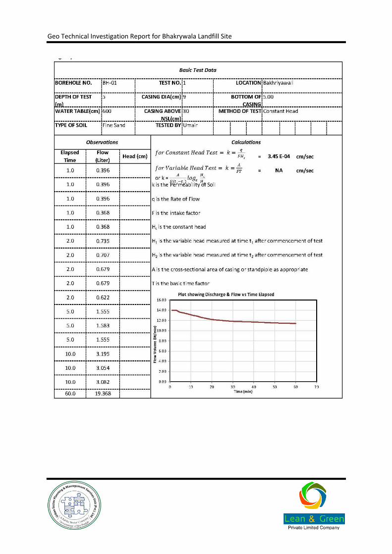
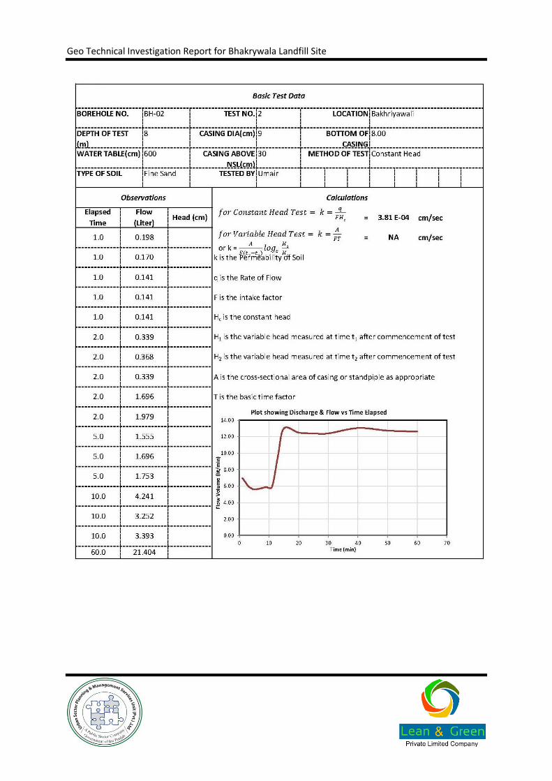
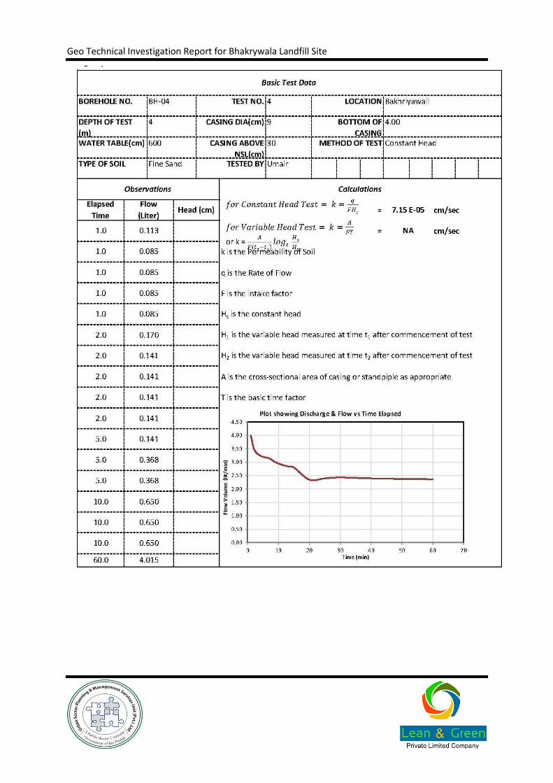
3.6. Field Permeability Test
Five (5) field permeability tests were carried out at different depths in the overburden soils. This yielded preliminary information about the order of magnitude and variability of the coefficient of permeability. The method of falling of variable head is more appropriate for clays. Therefore, Constant Head method was adopted for these tests as most of the test horizons were encountering sandy soils. The tests were carried out as per BS 5930, BS 1377 P5 and ASTM D2434-68 (1994). In all the cases, the boreholes were cased from the ground surface to the top of the soil column to be tested. The borehole drilled and was washed with clean water in order to clear the test zone. In this test, the head of water was maintained, and the volume of flow was measured as a function of time. The results of these tests are as follows:
Borehole No. Depth Material Coefficient of Permeability (cm/sec)
BH-01 5 Fine Sand 3.45E-04
BH-02 8 Fine Sand 3.81E-04
BH-03 3 Fine Sand 1.22E-04
BH-04 4 Fine Sand 7.15E-05
BH-05 8 Fine Sand 3.12E-04
Geo Technical Investigation Report for Bhakrywala Landfill Site
In addition to field testing, a number of laboratory tests, as listed in Table 1-2, were also conducted on selected soil samples. Results of these tests are helpful in classification of soil, determining engineering properties such as classification, compactness and suitability for construction material; the same is given in the Annexure B.2.1, which contains laboratory test results.
Brief description of all the laboratory tests and testing standards is given in the following sections.
4.1. Grain Size Analysis
Soil is an uncemented aggregate of mineral grains and decayed matter with liquid and gas in the empty spaces between the solid particles, which consists of an assemblage of discrete of particles of various sizes and shapes. This analysis consists of shaking the soil sample through a set of sieves, which decrease in opening sizes from top to bottom. The object is to group these particles into separate size ranges and to determine the relative proportions by dry weight, of each size range.
Grain size analysis is been conducted in two stages. Particles size distribution of coarse-grained soils is performed by sieve analysis while hydrometer analysis is conducted to establish distribution of fine-grained soils. Grain size analysis is carried out as per ASTM D422-63(07).
Based on the results of these analyses and the Atterberg limits, the soil is classified into groups and sub-groups according to their engineering behaviour. Generally two elaborate classification systems are used which are the American Association of State Highway and Transportation Officials (AASHTO) classification system and the Unified Soil Classification System (USCS). The AASHTO classification system (AASHTO M145 or ASTM D3282-09) is used mostly by highway departments for road design, whereas the USCS system (ASTM D2487-11) is used by geotechnical engineers for foundation design etc.
A total of one hundred twenty three (123) sieve analyses were conducted on the samples collected from the site.
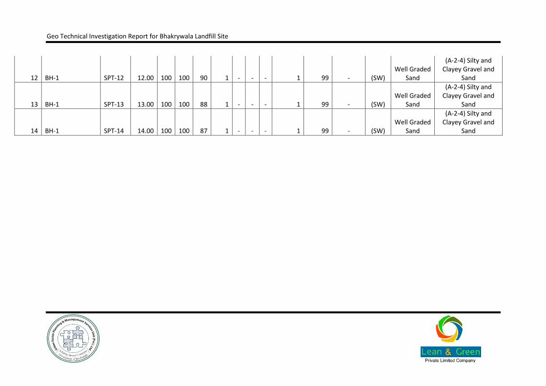
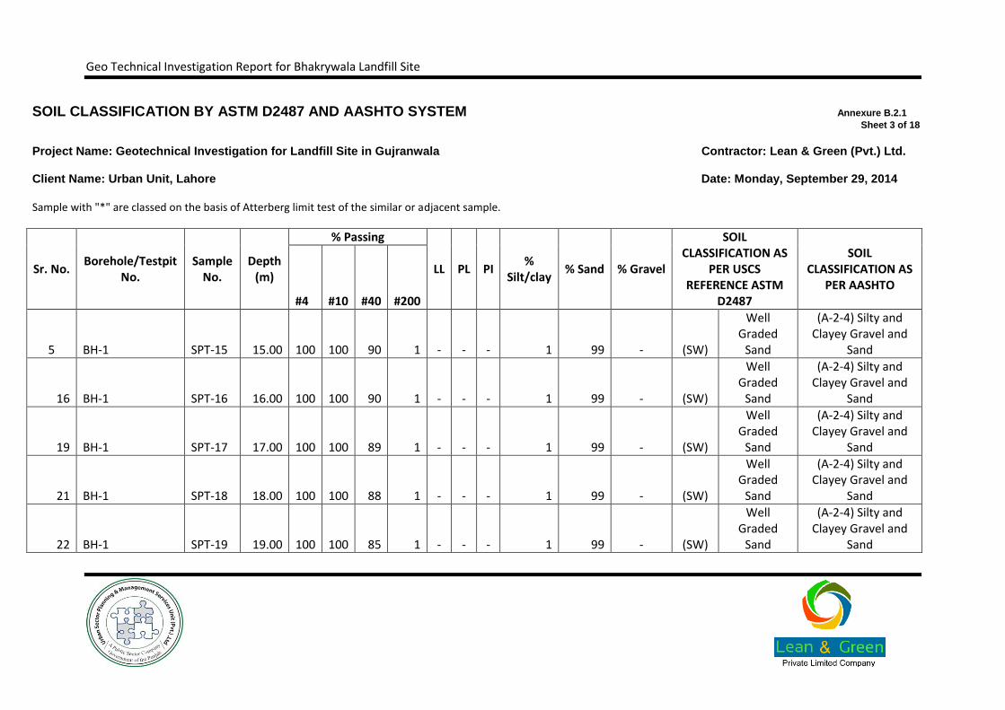
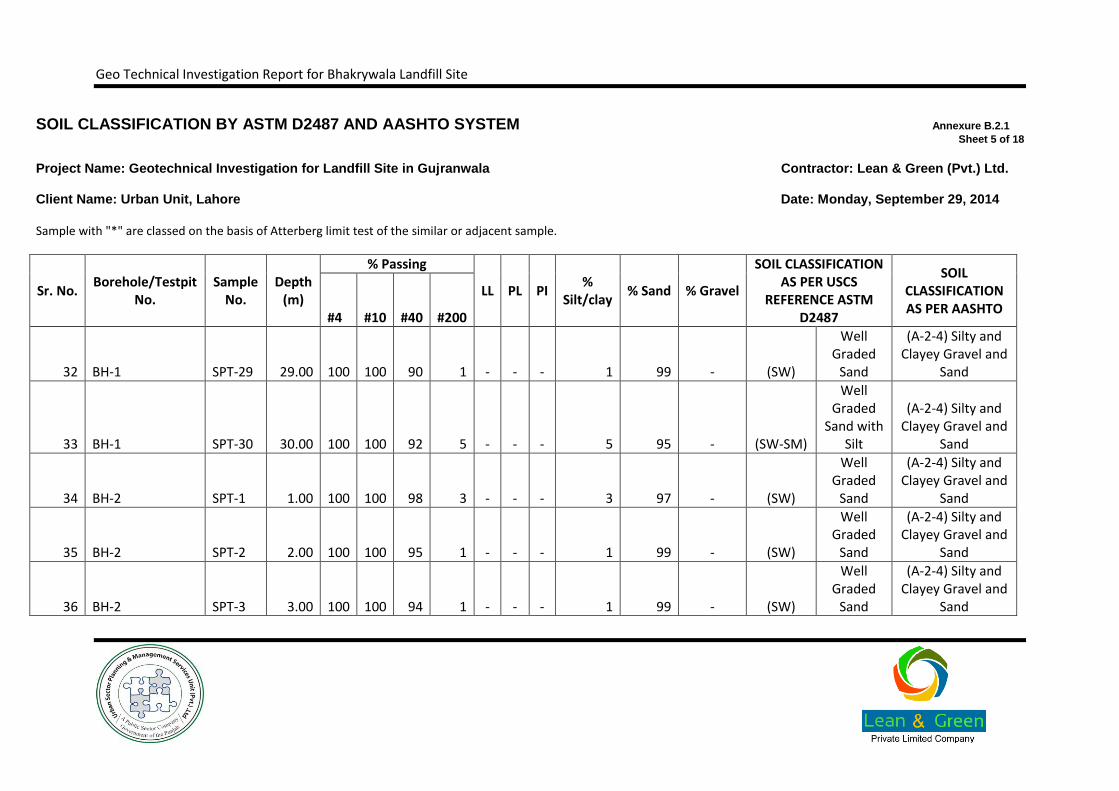
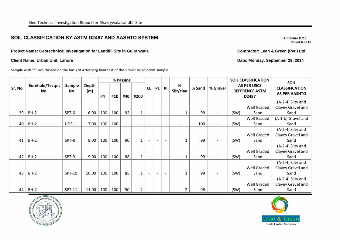
The classification test results indicate that the subsoil mostly comprises of CL, ML, SM, SP-SM/SW-SM groups on the basis of USCS System. The soils classified as granular indicated fines (passing # 200 sieve) ranging from 1% to 32%. The fine content in the cohesive soils were indicated as 80% to 98%.
4.2. Hydrometer Analysis
Hydrometer analysis is the process by which fine-grained soils, silts and clays, are graded. It is performed if the grain sizes are too small for sieve analysis. The basis for this test is Stoke’s Law for falling spheres in a viscous fluid in which the terminal velocity of fall depends on the grain diameter and the densities of the grain in suspension and of the fluid.
The soil sample is mixed in water, along with a dispersing agent to separate individual soil particles. The density of the soil suspension is determined with a hydrometer calibrated to read in grams of solids per litre after the sand settles out and again after the silt settles. Corrections are made for the density and temperature of the dispersing solution, as defined in ASTM D422-63(07).
A total of two (2) hydrometer tests performed on the soil samples indicated that the percent passing from a 0.02mm size ranged from 24% to 48% and percent passing from a 0.002mm size varied from 6% to 22%.
4. Laboratory Test Results
Geo Technical Investigation Report for Bhakrywala Landfill Site
4.3. Atterberg Limits
Atterberg limits, as described in ASTM D4318-00, are a basic measure of the critical water contents of a fine-grained soil, such as its shrinkage limit, plastic limit, and liquid limit. As a dry, clayey soil takes on increasing amounts of water, it undergoes dramatic and distinct changes in behaviour and consistency. Depending on the water content of the soil, it may appear in four states: solid, semi-solid, plastic and liquid. In each state, the consistency and behaviour of a soil is different and consequently so are its engineering properties.
Plastic limit (PL) is the moisture content at which the soil passes from the semisolid to the plastic state, as the moisture content is increased. It is determined by rolling out a thread of the fine portion of a soil on a flat, non-porous surface.
Liquid Limit (LL) is the moisture content at which a soil passes from the plastic state to a liquid state as the water content is increased.
Plasticity Index (PI) is the difference of moisture content at liquid and plastic limits (PI=LL-PL). A plot of Pi against LL provides the bases for classification of cohesive soils. It also provides insight into several soil characteristics such as compressibility and strength.
A total of five (5) Atterberg limit tests performed on the soil samples indicated that the liquid limit (LL) ranged from 30 to 31and plasticity index (PI) varied from 10 to 11, while three (3) samples showed a non-plastic (NP) behaviour.
4.4. Natural Moisture Content
Moisture content of soil is the ratio of the amount of water present in a soil sample to the solid mass of the soil. The knowledge of the in situ natural moisture content will give an idea of the state of soil in the field. It is essential in in establishing a correlation between soil behaviour and its index properties and determining the bearing capacity and settlement. The standard procedure is given in ASTM D2216-10.
The laboratory tests performed on four (4)relatively undisturbed soil samples extracted up to a maximum depth of 6m below NSL have yielded natural moisture content ranging from 16%to 31%.
4.5. Direct Shear Test
Direct shear test, according to ASTM D3080-11, is a laboratory to measure the shear strength properties of soil. It is performed on three or four specimens from a relatively undisturbed soil sample. A specimen is placed in a shear box which has two stacked rings to hold the sample; the contact between the two rings is at approximately the mid-height of the sample. A confining stress is applied vertically to the specimen, and the upper ring is pulled laterally until the sample fails, or through a specified strain. The load applied and the strain induced is recorded at frequent intervals to determine a stress-strain curve for each confining stress. This test is commonly used for dry or saturated sandy soils.
A total of four (4) direct shear tests were performed on the relatively undisturbed granular soil samples extracted from undisturbed soil samples extracted from boreholes using pitcher sampler. The results indicated
angles of internal friction varying from 33° to 37° with the corresponding cohesion intercept of zero.
Geo Technical Investigation Report for Bhakrywala Landfill Site
4.6. Unconfined Compressive Strength
The objective of the unconfined compression test is to determine the unconsolidated un-drained strength of a cohesive soil in an inexpensive manner. Fine-grained soils are usually tested in compression. Undisturbed specimens are cut from tube samples and disturbed specimens are loaded in compression, recording load and deflection measurements. The unconfined test uses axial loading without lateral confining pressures, making it the simplest and relatively quickest laboratory method of estimating strength of soil. Standard Procedure is given in ASTM D2166-13.
The project site area has a very thin cover of cohesive material in the upper 1 m only, therefore, no undisturbed soil sample was extracted from the cohesive material. Therefore, the unconfined compression test was not performed.
4.7. Oedometer Test (OED)
An oedometer test is a kind of geotechnical investigation performed in geotechnical engineering that measures a soil's consolidation properties. Oedometer tests, as described in ASTM D2435-11, are performed by applying different loads to a soil sample and measuring the deformation response. The results from these tests are used to predict how a soil in the field will deform in response to a change in effective stress.
Oedometer tests are designed to simulate the one-dimensional consolidation and drainage conditions that soils experience in the field. To simulate these conditions, rigid confining rings are used to prevent lateral displacement of the soil sample.
The project site area has a very thin cover of cohesive material in the upper 1 m only, therefore, no undisturbed soil sample was extracted from the cohesive material. Therefore, the unconfined compression test was not performed.
4.8. Chemical Tests
The chemical tests are performed, as per BS 1377 Part 3, to check the acidity of the soil and the quantities of aggressive materials in the ground, such as Sulphates, Chlorides and Organic materials which may attack buried concrete or metal.
Chemical tests carried out on two (2) water samples indicated that total soluble solids varied as 355 to 460ppm and chloride contents from 67 to 98ppm.

Geo Technical Investigation Report for Bhakrywala Landfill Site
5.1. Lithology of Project Area
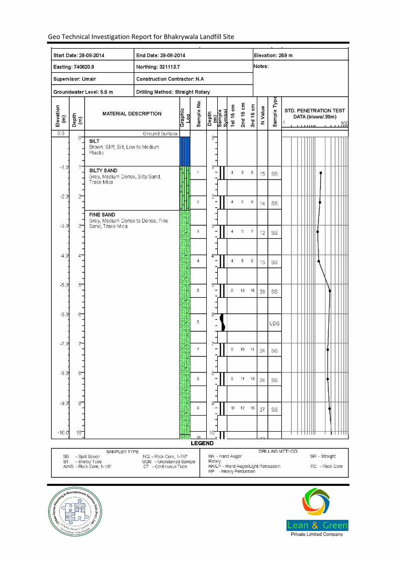
The top surface comprises vegetative cover which is underlain by Lean Clay/Silt (Soft to firm), up to 1 m depth, the material is underlain by Silty Sand (Medium Dense to Dense) up to a maximum investigated depth of 30 m depth below NSL
5.2. Ground Conditions
The ground conditions consist of the following general conditions summarized below in Table 5-1
Table 5-1: Summary of Ground Conditions
Borehole No.
Top Depth (m)
Bottom Depth (m)
Description Title Description
1 0 1 1 SILT
1 1 4 3 SILTY SAND
1 4 10.11 6.10 FINE SAND
1 10.11 20.21 10.10 FINE SAND
1 20.21 30 9.8 FINE SAND
2 0 1 1 SILT
2 1 2 1 SILTY SAND
2 2 10.10 8.10 FINE SAND
2 10.10 20.21 10.10 FINE SAND
2 20.20 30 9.78 FINE SAND
3 0 1 1 SILT
3 1 2.5 1.5 SILTY SAND
3 2.5 10.10 7.6 FINE SAND
3 10.11 20.22 10.11 FINE SAND
3 20.22 30 9.78 FINE SAND
4 0 1 1 SILT
4 1 2 1 SILTY SAND
5. Ground Conditions and Engineering Properties

Geo Technical Investigation Report for Bhakrywala Landfill Site
Borehole No.
Top Depth (m)
Bottom Depth (m)
Description Title Description
4 2 10.11 8.11 FINE SAND
4 10.11 20.22 10.11 FINE SAND
4 20.22 30 9.78 FINE SAND
5.3. Groundwater Table
Groundwater was encountered at a depth of about 6 m in the boreholes drilled up to a maximum depth of 30 m below NSL. However, seasonal variation can result into increase of groundwater table, in the upper layer of soil
5.4. Geotechnical Design Parameters
5.4.1. Summary of Design Parameters
Table 5-2 summarizes the recommended layer thicknesses used in parameters selection and design recommendation evaluated.
Table 5-2: Summary of Design Parameters
Material Type
Depth below NSL
D (m)
Bulk Density
(g/cm³)
Coefficient of Volume Compressibility
(mv)cm2/kg
Angle of Internal Friction
Phi (°)
Cohesion
C (kg/cm²)
Young’s Modulus
E (MPa)
Lean Clay/Silt
0.0-3.0 1.65 0.012 - 0.35 1.0
Silty Sand/Fine Sand
3.0-30.0
1.75 - 32.00 - 7.5
5.4.2. Discussion on Design Parameters
The design parameters have been evaluated considering results of field geotechnical investigation, laboratory testing, experience, and judgment of author of this report in the similar ground. The ground condition reveals mostly Cohesive (silt/Lean Clay)at the foundation laying depth of about 1.5m below NSL.
5.4.3. Geotechnical Design Criteria
The foundations of all the structures should meet the following design criteria:
These should be safe against shear failure of the supporting ground. A factor of safety of 3 is adopted for this purpose.

Geo Technical Investigation Report for Bhakrywala Landfill Site
These should not settle excessively under the service loads. A limit of 25mm has been put on the total settlement of individual foundations. Similarly, the angular distortion between the two adjacent foundations should not exceed1/500.
The bedding of pipelines should be rigid enough to remain stable. This should be attained by compacting the pipe bedding to at least 95% Modified Proctor Compaction (70% Relative density).
If mat foundation is adopted, it should not settle beyond limits under the service loads. A limit of 50 mm has been put on the total settlement of foundations (corresponds to adifferential settlement of about 35 mm between the centre and edge of the mat foundation).
Geo Technical Investigation Report for Bhakrywala Landfill Site
6.1. Earthworks
6.1.1. Ground Preparation
The topsoil at site mostly belongs to vegetative material. Initial site preparation will require removal of such contaminated/vegetative topsoil. Such soil may be used in the landscaping.
6.2. Foundations
6.2.1. Proposed Structures
The proposed structures are expected to be low level loading as they will mostly comprise administration buildings etc. Usually this kind of buildings can be supported on shallow foundation. Considering the ground conditions, it is recommended to support these buildings on strip foundation with after recommended ground improvement in case any weak pocket observed during construction at site.
6.2.2. Design of Shallow Foundations
The evaluation of the bearing capacity of the Square/Rectangular Foundation has been done using approach given by Terzaghi, Elastic theory and other established correlations. The analysis has been carried out for a depth of foundation 1.5 m below NSL. The bearing capacity curves are presented in Annexure B.3.1.
Similarly, the evaluation of the bearing capacity of the Strip Foundation has been done. The analysis has been carried out for a depth of foundation 1.5 m below NSL. The bearing capacity curves are presented as Annexure.
6.2.3. Modulus of Subgrade Reaction
Modulus of sub-grade reaction Ks can be evaluated using the evaluated allowable bearing pressure, respective structural pressure, and factor of safety (FOS). The expression for its calculation is given below:
For Strip and Square Footings with 25.4mm (1 inch) tolerable settlement
For Raft / Mat Footings with 50.8 mm (2 inch) tolerable settlement
6. Engineering Considerations

Geo Technical Investigation Report for Bhakrywala Landfill Site
6.2.4. Placement of Granular Fill
If any soft and loose material encountered, at foundation excavation level, during construction, then it should be further excavated and replaced with suitable granular material in proper compaction.
The availability of the sound ground must be confirmed before placement of the foundation pad. An experienced engineer should confirm the soundness of the excavation base as the upper soil is weak.
The excavated surface must be proof compacted to at least 95% of the Modified AASHTO Dry Density before placement of foundation or pavement.
The suitable granular material, if used, should comprise granular material, free draining, well graded, non-plastic and having particle size in a range of 0.075 mm to maximum 75 mm. The maximum content of fines should be limit to 10%. The minimum compaction requirement for granular back fill or proof rolling below foundation base should be at least 95% Modified AASHTO dry density or 75 % Relative Density.
6.3. Lateral Earth Pressure
6.3.1. Static Earth Pressure Coefficients
In case of buried structures and retaining walls, use of cohesion-less backfill is recommended. The evaluation of static earth pressure on buried wall / retaining walls depends upon the movement allowed for in the design, configuration of the wall, backfill geometry and the type of soil used as backfill. For smooth vertical walls with horizontal backfill, the following simplified expressions can be used for determination of coefficients of Lateral Earth Pressure.
Coefficient of Active Earth Pressure
Coefficient of Earth Pressure at Rest
Coefficient of Passive Earth Pressure
Geo Technical Investigation Report for Bhakrywala Landfill Site
Where is effective Angle of Internal Friction of backfill soil.
The effective Angle of Friction of typical granular soils available in Punjab may be used as 30 degree.
6.3.2. Dynamic Earth Pressure Coefficients
For evaluation of earth pressure under earthquake conditions, the equations proposed by Mononobe-Okabe may be used.
6.4. Construction of Roads & Embankments
6.4.1. Formation of Subgrade and Embankment
Subgrade consisting of Silty Sand / Sandy Silt usually belongs to A4 material is found at site as per geotechnical investigation and visually inspected at site during site reconnaissance. However, there is presence of A-6 soil at surface as well. Therefore, it must be noted that only A-4 soils should be used for subgrade and embankment construction.
It is recommended to adopt an average design CBR of existing subgrade as 7, which is inline the above the minimum CBR value requirements of the subgrade material as per NHA Specifications.
6.4.2. Borrow Placement and Compaction
Before placement of the Earth fill/borrow fill, in-situ soil should be proof-rolled to achieve a minimum compaction level of 90% Modified AASHTO density.
The following maximum layer thickness, minimum compaction is recommended for various elements of embankment:
Table 6-1: Borrow Compaction Parameters
Material Type Material Type
Maximum Compacted Layer Thickness
(cm)
Recommended Modified AASHTO Compaction
(%)
(a). A-4 as Embankment & Subgrade
Top 30cm A-4 15 95
30cm – 75cm A-4 20 93
Below 75cm A-4 20 90

Geo Technical Investigation Report for Bhakrywala Landfill Site
6.5. Constraints and Risks
6.5.1. Damp Proofing and Surface Drainage
Principle constraints include following:
Proper paving should be provided along the periphery of the Structure.
All the backfilling of the foundation above concrete pad should be done with non swell cohesive material to avoid seepage of water in the foundation base. Alternatively, the top 30cm of any backfilling should be carried out with non-swelling cohesive soil.
Adequate water proofing/damp proofing shall be provided for the structure. To avoid problem regarding moisture, it is recommended to adopt water-reducing admixtures in concrete.
Cementitious coatings should also be provided to avoid moisture movement through the concrete.
6.5.2. Contaminated Land
The spillage of fuels, oils or other contaminants on the site should be prohibited and servicing of tools, plants, and machinery during the construction period should be managed to prevent pollution, while large numbers of machines are operating on the site.
6.5.3. Quality Control
The following precautions must be ensured for better quality control at site for construction stage:
The water cement ratio of the concrete should be monitored properly for better quality of concrete.
The compaction works should be supervised by experienced geotechnical engineer. The compaction of the area under foundation and other major load bearing locations should be certified by a licensed professional engineer for its laying as per specifications.
6.6. Design and Construction Aspects of Land Fill
6.6.1. Formation of Temporary and Final Cover
Soil or similar inert material should be used for the lifetime of the land fill site, to cover the waste on a regular basis. Extra thickness of "final cover" material shall also be required once the site has reached completion.
The simple spreading of daily cover is very effective way to reduce the attraction of waste to birds, suppress odours, prevent fly infestations, discourage rats and other animals, to reduce exposure to atmosphere conditions and to reduce wind blow litter.
Ideally, cover material should be taken from within the site, increasing the available space for waste disposal and reducing the need to bring material from elsewhere.
The material excavated from the site should be adequate for use a temporary and final cover material. Final confirmation should be made on remoulded permeability of the representative samples taken from the borrow source if adopted. At this time we expect that the soil removed during excavation will be used.
The soil should be compacted to at least 95 percent of the modified proctor density within a moisture content range of 0 to 3 percent wet of optimum.
Geo Technical Investigation Report for Bhakrywala Landfill Site
6.6.2. Excavation at Site
The excavation required for the construction of foundation up to a shallow depth of about 3m, can be made without provision of any supporting system. The provision of dewatering must be kept in the scope of work of construction due to possibility of rainy season, during construction.
The excavation for the land fill area can be easily done with simple mechanical means, which is being practice currently at site. Since the adjacent areas are being used for agriculture purpose therefore, no major stability issues are anticipated to results in to property loss, however, it is recommended to excavate at a slope angle established by hit and trial method at site for an excavation of about 6 m, which is foreseen in the light of current ground conditions.
As a broad guideline it is suggested to adopt a slope angle of 2H:1V, however, based on hit and trial method adopted at site, the angle can be further steepened.
The base of the land fill site should be design for a permeability of existing base soil in a range of 3.12 to 3.18x10⁻⁴. For sealing of the base of the land fill site, a clay liner may be adopted, for which suitable soils would be high plastic clays, locally the areas near sambrial/Sialkot, material of high plasticity index (PI above 15 is usually available, which may be used blended with additives to improve the permeability values. Alternatively, geotextile based clay liner may be adopted.
6.6.3. Liquefaction Potential
Liquefaction is a loss of the shear strength of a soil that occurs when the ground experiences strong ground shaking. The phenomenon may result in large total and/or differential settlement beneath Structures founded on the liquefying soils. In order for the potential effects of liquefaction to be manifested at the ground surface, the soils generally have to be granular, loose to moderately dense, saturated relatively near the ground surface, and must be subjected to a sufficient magnitude and duration of shaking.
According to the grading plans for the proposed Landfill Site, surficial soils will be removed so that the proposed filling will be directly underlain by medium dense to dense Sands. With the removal of upper alluvium, the nearest groundwater will be on the order of 1 to 2m below the base of the landfill. Due to the lack of a week sandy soil, the relatively low design site acceleration being in zone 2A, and the competency of the Sands at about 6 m depth, the potential for significant, large-scale liquefaction effects and associated dynamic settlement to cause damage to the composite liner system and other site facilities is very low..
6.6.4. Cement Type
It is recommended to use Ordinary Portland Cement as per results of chemical tests performed at soil and water samples from site.
Geo Technical Investigation Report for Bhakrywala Landfill Site
In summary it is concluded that
The top surface comprises vegetative cover which is underlain by Lean Clay/Silt (Soft to firm), up to 1 m depth, the material is underlain by Silty Sand (Medium Dense to Dense) up to a maximum investigated depth of 30 m depth below NSL
Groundwater was encountered at a depth of about 6 m in the boreholes drilled up to a maximum depth of 30 m below NSL. However, seasonal variation can result into increase of groundwater table, in the upper layer of soil
The bearing capacity curves are provided in the Annexure B.3
The evaluation of the bearing capacity of the Square/Rectangular Foundation has been done using approach given by Terzaghi, Elastic theory and other established correlations. The analysis has been carried out for a depth of foundation 1.5 m below NSL.
Similarly, the evaluation of the bearing capacity of the Strip Foundation has been done. The analysis has been carried out for a depth of foundation 1.5 m below NSL.
Proper paving should be provided along the periphery of the Structure.
All the backfilling of the foundation above concrete pad should be done with non swell cohesive material to avoid seepage of water in the foundation base. Alternatively, the top 30cm of any backfilling should be carried out with non-swelling cohesive soil.
Adequate water proofing/damp proofing shall be provided for the structure. To avoid problem regarding moisture, it is recommended to adopt water-reducing admixtures in concrete.
If any soft and loose material encountered, at foundation excavation level, during construction, then it should be further excavated and replaced with suitable granular material in proper compaction.
Cementitious coatings should also be provided to avoid moisture movement through the concrete.
“The base of the land fill site should be design for a permeability of existing base soil in a range of 3.12 to 3.18x10⁻⁴. For sealing of the base of the land fill site, a clay liner may be adopted, for which suitable soils would be high plastic clays, locally the areas near sambrial/Sialkot, material of high plasticity index (PI above 15 is usually available, which may be used blended with additives to improve the permeability values. Alternatively, geotextile based clay liner may be adopted.”
7. Conclusions

Geo Technical Investigation Report for Bhakrywala Landfill Site
Following References and specialized Software have been utilized in the development of this report:
Foundation Analysis and Design by Joseph E. Bowles
Winlog & Winfence (softwares for generation of graphical borehole logs and subsurface profiles)
NovoSPT a software from Novotech (for assessment and correlation of standard penetration resistance data for analysis and design)
Building Code of Pakistan as given on Pakistan Engineering Council Website
ASTM Book volume 4.08 (Soils and Rocks)
Geotechnical Earthquake Engineering by Kramer
8. References

Geo Technical Investigation Report for Bhakrywala Landfill Site
Annexure A. Drawings
Geo Technical Investigation Report for Bhakrywala Landfill Site
A.1. Site Location Map

Geo Technical Investigation Report for Bhakrywala Landfill Site

Geo Technical Investigation Report for Bhakrywala Landfill Site
A.2. Geotechnical Investigation Plan
Geo Technical Investigation Report for Bhakrywala Landfill Site

Geo Technical Investigation Report for Bhakrywala Landfill Site
A.3. Geological Map of the Project Area
Geo Technical Investigation Report for Bhakrywala Landfill Site
Geo Technical Investigation Report for Bhakrywala Landfill Site
A.4. Seismic Map of Punjab

Geo Technical Investigation Report for Bhakrywala Landfill Site

Geo Technical Investigation Report for Bhakrywala Landfill Site
Annexure B. Figures

Geo Technical Investigation Report for Bhakrywala Landfill Site
B.1. Variation of SPT Blows with Depth

Geo Technical Investigation Report for Bhakrywala Landfill Site

Geo Technical Investigation Report for Bhakrywala Landfill Site
B.2. Summary of Laboratory Test Results

Geo Technical Investigation Report for Bhakrywala Landfill Site
B.2.1. Laboratory Classification Testing
Geo Technical Investigation Report for Bhakrywala Landfill Site
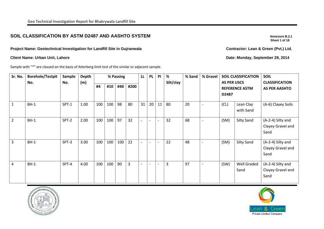
SOIL CLASSIFICATION BY ASTM D2487 AND AASHTO SYSTEM Annexure B.2.1
Sheet 1 of 18
Project Name: Geotechnical Investigation for Landfill Site in Gujranwala Contractor: Lean & Green (Pvt.) Ltd.
Client Name: Urban Unit, Lahore Date: Monday, September 29, 2014
Sample with "*" are classed on the basis of Atterberg limit test of the similar or adjacent sample.
Sr. No. Borehole/Testpit
No.
Sample
No.
Depth
(m)
% Passing LL PL PI %
Silt/clay
% Sand % Gravel SOIL CLASSIFICATION
AS PER USCS
REFERENCE ASTM
D2487
SOIL
CLASSIFICATION
AS PER AASHTO #4 #10 #40 #200
1 BH-1 SPT-1 1.00 100 100 98 80 31 20 11 80 20 - (CL) Lean Clay
with Sand
(A-6) Clayey Soils
2 BH-1 SPT-2 2.00 100 100 97 32 - - - 32 68 - (SM) Silty Sand (A-2-4) Silty and
Clayey Gravel and
Sand
3 BH-1 SPT-3 3.00 100 100 100 22 - - - 22 48 - (SM) Silty Sand (A-2-4) Silty and
Clayey Gravel and
Sand
4 BH-1 SPT-4 4.00 100 100 90 3 - - - 3 97 - (SW) Well Graded
Sand
(A-2-4) Silty and
Clayey Gravel and
Sand
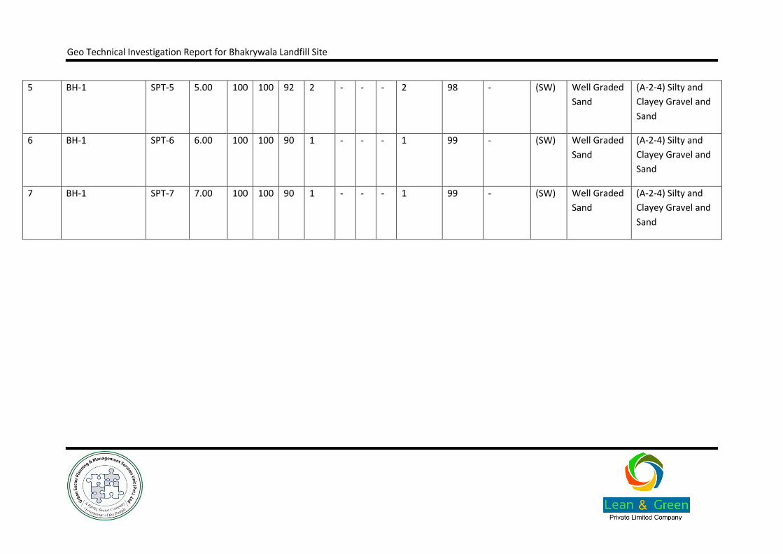
Geo Technical Investigation Report for Bhakrywala Landfill Site
5 BH-1 SPT-5 5.00 100 100 92 2 - - - 2 98 - (SW) Well Graded
Sand
(A-2-4) Silty and
Clayey Gravel and
Sand
6 BH-1 SPT-6 6.00 100 100 90 1 - - - 1 99 - (SW) Well Graded
Sand
(A-2-4) Silty and
Clayey Gravel and
Sand
7 BH-1 SPT-7 7.00 100 100 90 1 - - - 1 99 - (SW) Well Graded
Sand
(A-2-4) Silty and
Clayey Gravel and
Sand

Geo Technical Investigation Report for Bhakrywala Landfill Site
SOIL CLASSIFICATION BY ASTM D2487 AND AASHTO SYSTEM Annexure B.2.1
Sheet 2 of 18
Project Name: Geotechnical Investigation for Landfill Site in Gujranwala Contractor: Lean & Green (Pvt.) Ltd.
Client Name: Urban Unit, Lahore Date: Monday, September 29, 2014
Sample with "*" are classed on the basis of Atterberg limit test of the similar or adjacent sample.
Sr. No. Borehole/Testpit
No. Sample
No. Depth
(m)
% Passing
LL PL PI %
Silt/clay % Sand % Gravel
SOIL CLASSIFICATION AS
PER USCS REFERENCE ASTM
D2487
SOIL CLASSIFICATION AS
PER AASHTO #4 #10 #40 #200
8 BH-1 SPT-8 8.00 100 100 90 1 - - - 1 99 - (SW) Well Graded
Sand
(A-2-4) Silty and Clayey Gravel and
Sand
9 BH-1 SPT-9 9.00 100 100 92 1 - - - 1 99 - (SW) Well Graded
Sand
(A-2-4) Silty and Clayey Gravel and
Sand
10 BH-1 SPT-10 10.00 100 100 100 - - - - - 100 - (SW) Well Graded
Sand
(A-2-4) Silty and Clayey Gravel and
Sand
11 BH-1 SPT-11 11.00 100 100 95 1 - - - 1 99 - (SW) Well Graded
Sand
(A-2-4) Silty and Clayey Gravel and
Sand
Geo Technical Investigation Report for Bhakrywala Landfill Site
12 BH-1 SPT-12 12.00 100 100 90 1 - - - 1 99 - (SW) Well Graded
Sand
(A-2-4) Silty and Clayey Gravel and
Sand
13 BH-1 SPT-13 13.00 100 100 88 1 - - - 1 99 - (SW) Well Graded
Sand
(A-2-4) Silty and Clayey Gravel and
Sand
14 BH-1 SPT-14 14.00 100 100 87 1 - - - 1 99 - (SW) Well Graded
Sand
(A-2-4) Silty and Clayey Gravel and
Sand
Geo Technical Investigation Report for Bhakrywala Landfill Site
SOIL CLASSIFICATION BY ASTM D2487 AND AASHTO SYSTEM Annexure B.2.1
Sheet 3 of 18
Project Name: Geotechnical Investigation for Landfill Site in Gujranwala Contractor: Lean & Green (Pvt.) Ltd.
Client Name: Urban Unit, Lahore Date: Monday, September 29, 2014
Sample with "*" are classed on the basis of Atterberg limit test of the similar or adjacent sample.
Sr. No. Borehole/Testpit
No. Sample
No. Depth
(m)
% Passing
LL PL PI %
Silt/clay % Sand % Gravel
SOIL CLASSIFICATION AS
PER USCS REFERENCE ASTM
D2487
SOIL CLASSIFICATION AS
PER AASHTO #4 #10 #40 #200
5 BH-1 SPT-15 15.00 100 100 90 1 - - - 1 99 - (SW)
Well Graded
Sand
(A-2-4) Silty and Clayey Gravel and
Sand
16 BH-1 SPT-16 16.00 100 100 90 1 - - - 1 99 - (SW)
Well Graded
Sand
(A-2-4) Silty and Clayey Gravel and
Sand
19 BH-1 SPT-17 17.00 100 100 89 1 - - - 1 99 - (SW)
Well Graded
Sand
(A-2-4) Silty and Clayey Gravel and
Sand
21 BH-1 SPT-18 18.00 100 100 88 1 - - - 1 99 - (SW)
Well Graded
Sand
(A-2-4) Silty and Clayey Gravel and
Sand
22 BH-1 SPT-19 19.00 100 100 85 1 - - - 1 99 - (SW)
Well Graded
Sand
(A-2-4) Silty and Clayey Gravel and
Sand

Geo Technical Investigation Report for Bhakrywala Landfill Site
23 BH-1 SPT-20 20.00 100 100 90 1 - - - 1 99 - (SW)
Well Graded
Sand
(A-2-4) Silty and Clayey Gravel and
Sand
24 BH-1 SPT-21 21.00 100 100 95 1 - - - 1 99 - (SW)
Well Graded
Sand
(A-2-4) Silty and Clayey Gravel and
Sand

Geo Technical Investigation Report for Bhakrywala Landfill Site
SOIL CLASSIFICATION BY ASTM D2487 AND AASHTO SYSTEM Annexure B.2.1
Sheet 4 of 18
Project Name: Geotechnical Investigation for Landfill Site in Gujranwala Contractor: Lean & Green (Pvt.) Ltd.
Client Name: Urban Unit, Lahore Date: Monday, September 29, 2014
Sample with "*" are classed on the basis of Atterberg limit test of the similar or adjacent sample.
Sr. No. Borehole/Testpit
No. Sample
No. Depth
(m)
% Passing
LL PL PI %
Silt/clay % Sand % Gravel
SOIL CLASSIFICATION AS
PER USCS REFERENCE ASTM
D2487
SOIL CLASSIFICATION AS
PER AASHTO #4 #10 #40 #200
25 BH-1 SPT-22 22.00 100 100 92 1 - - - 1 99 - (SW)
Well Graded
Sand
(A-2-4) Silty and Clayey Gravel and
Sand
26 BH-1 SPT-23 23.00 100 100 93 1 - - - 1 99 - (SW)
Well Graded
Sand
(A-2-4) Silty and Clayey Gravel and
Sand
27 BH-1 SPT-24 24.00 100 100 90 1 - - - 1 99 - (SW)
Well Graded
Sand
(A-2-4) Silty and Clayey Gravel and
Sand
28 BH-1 SPT-25 25.00 100 100 88 1 - - - 1 99 - (SW)
Well Graded
Sand
(A-2-4) Silty and Clayey Gravel and
Sand
29 BH-1 SPT-26 26.00 100 100 90 1 - - - 1 99 - (SW)
Well Graded
Sand
(A-2-4) Silty and Clayey Gravel and
Sand

Geo Technical Investigation Report for Bhakrywala Landfill Site
30 BH-1 SPT-27 27.00 100 100 89 1 - - - 1 99 - (SW)
Well Graded
Sand
(A-2-4) Silty and Clayey Gravel and
Sand
31 BH-1 SPT-28 28.00 100 100 94 1 - - - 1 99 - (SW)
Well Graded
Sand
(A-2-4) Silty and Clayey Gravel and
Sand
Geo Technical Investigation Report for Bhakrywala Landfill Site
SOIL CLASSIFICATION BY ASTM D2487 AND AASHTO SYSTEM Annexure B.2.1
Sheet 5 of 18
Project Name: Geotechnical Investigation for Landfill Site in Gujranwala Contractor: Lean & Green (Pvt.) Ltd.
Client Name: Urban Unit, Lahore Date: Monday, September 29, 2014
Sample with "*" are classed on the basis of Atterberg limit test of the similar or adjacent sample.
Sr. No. Borehole/Testpit
No. Sample
No. Depth
(m)
% Passing
LL PL PI %
Silt/clay % Sand % Gravel
SOIL CLASSIFICATION AS PER USCS
REFERENCE ASTM D2487
SOIL CLASSIFICATION AS PER AASHTO
#4 #10 #40 #200
32 BH-1 SPT-29 29.00 100 100 90 1 - - - 1 99 - (SW)
Well Graded
Sand
(A-2-4) Silty and Clayey Gravel and
Sand
33 BH-1 SPT-30 30.00 100 100 92 5 - - - 5 95 - (SW-SM)
Well Graded
Sand with Silt
(A-2-4) Silty and Clayey Gravel and
Sand
34 BH-2 SPT-1 1.00 100 100 98 3 - - - 3 97 - (SW)
Well Graded
Sand
(A-2-4) Silty and Clayey Gravel and
Sand
35 BH-2 SPT-2 2.00 100 100 95 1 - - - 1 99 - (SW)
Well Graded
Sand
(A-2-4) Silty and Clayey Gravel and
Sand
36 BH-2 SPT-3 3.00 100 100 94 1 - - - 1 99 - (SW)
Well Graded
Sand
(A-2-4) Silty and Clayey Gravel and
Sand

Geo Technical Investigation Report for Bhakrywala Landfill Site
37 BH-2 SPT-4 4.00 100 100 93 1 - - - 1 99 - (SW)
Well Graded
Sand
(A-2-4) Silty and Clayey Gravel and
Sand
38 BH-2 SPT-5 5.00 100 100 90 1 - - - 1 99 - (SW)
Well Graded
Sand
(A-2-4) Silty and Clayey Gravel and
Sand
Geo Technical Investigation Report for Bhakrywala Landfill Site
SOIL CLASSIFICATION BY ASTM D2487 AND AASHTO SYSTEM Annexure B.2.1
Sheet 6 of 18
Project Name: Geotechnical Investigation for Landfill Site in Gujranwala Contractor: Lean & Green (Pvt.) Ltd.
Client Name: Urban Unit, Lahore Date: Monday, September 29, 2014
Sample with "*" are classed on the basis of Atterberg limit test of the similar or adjacent sample.
Sr. No. Borehole/Testpit
No. Sample
No. Depth
(m)
% Passing
LL PL PI %
Silt/clay % Sand % Gravel
SOIL CLASSIFICATION AS PER USCS
REFERENCE ASTM D2487
SOIL CLASSIFICATION AS PER AASHTO
#4 #10 #40 #200
39 BH-2 SPT-6 6.00 100 100 92 1 - - - 1 99 - (SW) Well Graded
Sand
(A-2-4) Silty and Clayey Gravel and
Sand
40 BH-2 UDS-1 7.00 100 100 - - - - - - 100 - (SW) Well Graded
Sand (A-1-b) Gravel and
Sand
41 BH-2 SPT-8 8.00 100 100 90 1 - - - 1 99 - (SW) Well Graded
Sand
(A-2-4) Silty and Clayey Gravel and
Sand
42 BH-2 SPT-9 9.00 100 100 88 1 - - - 1 99 - (SW) Well Graded
Sand
(A-2-4) Silty and Clayey Gravel and
Sand
43 BH-2 SPT-10 10.00 100 100 85 1 - - - 1 99 - (SW) Well Graded
Sand
(A-2-4) Silty and Clayey Gravel and
Sand
44 BH-2 SPT-11 11.00 100 100 90 2 - - - 2 98 - (SW) Well Graded
Sand
(A-2-4) Silty and Clayey Gravel and
Sand

Geo Technical Investigation Report for Bhakrywala Landfill Site
45 BH-2 SPT-12 12.00 100 100 92 1 - - - 1 99 - (SW) Well Graded
Sand
(A-2-4) Silty and Clayey Gravel and
Sand

Geo Technical Investigation Report for Bhakrywala Landfill Site
SOIL CLASSIFICATION BY ASTM D2487 AND AASHTO SYSTEM Annexure B.2.1
Sheet 7 of 18
Project Name: Geotechnical Investigation for Landfill Site in Gujranwala Contractor: Lean & Green (Pvt.) Ltd.
Client Name: Urban Unit, Lahore Date: Monday, September 29, 2014
Sample with "*" are classed on the basis of Atterberg limit test of the similar or adjacent sample.
Sr. No. Borehole/Testpit
No. Sample
No. Depth
(m)
% Passing
LL PL PI %
Silt/clay % Sand % Gravel
SOIL CLASSIFICATION AS
PER USCS REFERENCE ASTM
D2487
SOIL CLASSIFICATION AS PER AASHTO
#4 #10 #40 #200
46 BH-2 SPT-13 13.00 100 100 88 1 - - - 1 99 - (SW) Well Graded
Sand
(A-2-4) Silty and Clayey Gravel and
Sand
47 BH-2 SPT-14 14.00 100 100 90 1 - - - 1 99 - (SW) Well Graded
Sand
(A-2-4) Silty and Clayey Gravel and
Sand
48 BH-2 SPT-15 15.00 100 100 87 1 - - - 1 99 - (SW) Well Graded
Sand
(A-2-4) Silty and Clayey Gravel and
Sand
49 BH-2 SPT-16 16.00 100 100 85 1 - - - 1 99 - (SW) Well Graded
Sand
(A-2-4) Silty and Clayey Gravel and
Sand
50 BH-2 SPT-17 17.00 100 100 88 1 - - - 1 99 - (SW) Well Graded
Sand
(A-2-4) Silty and Clayey Gravel and
Sand
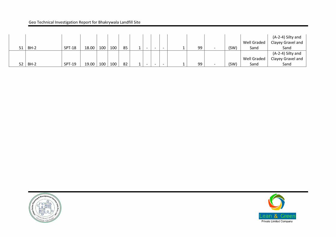
Geo Technical Investigation Report for Bhakrywala Landfill Site
51 BH-2 SPT-18 18.00 100 100 85 1 - - - 1 99 - (SW) Well Graded
Sand
(A-2-4) Silty and Clayey Gravel and
Sand
52 BH-2 SPT-19 19.00 100 100 82 1 - - - 1 99 - (SW) Well Graded
Sand
(A-2-4) Silty and Clayey Gravel and
Sand

Geo Technical Investigation Report for Bhakrywala Landfill Site
SOIL CLASSIFICATION BY ASTM D2487 AND AASHTO SYSTEM Annexure B.2.1
Sheet 8 of 18
Project Name: Geotechnical Investigation for Landfill Site in Gujranwala Contractor: Lean & Green (Pvt.) Ltd.
Client Name: Urban Unit, Lahore Date: Monday, September 29, 2014
Sample with "*" are classed on the basis of Atterberg limit test of the similar or adjacent sample.
Sr. No. Borehole/Testpit
No. Sample
No. Depth
(m)
% Passing
LL PL PI %
Silt/clay % Sand % Gravel
SOIL CLASSIFICATION AS
PER USCS REFERENCE ASTM
D2487
SOIL CLASSIFICATION AS PER AASHTO
#4 #10 #40 #200
53 BH-2 SPT-20 20.00 100 100 90 1 - - - 1 99 - (SW)
Well Graded
Sand
(A-2-4) Silty and Clayey Gravel and
Sand
54 BH-2 SPT-21 21.00 100 100 93 1 - - - 1 99 - (SW)
Well Graded
Sand
(A-2-4) Silty and Clayey Gravel and
Sand
55 BH-2 SPT-22 22.00 100 100 87 1 - - - 1 99 - (SW)
Well Graded
Sand
(A-2-4) Silty and Clayey Gravel and
Sand
56 BH-2 SPT-23 23.00 100 100 90 1 - - - 1 99 - (SW)
Well Graded
Sand
(A-2-4) Silty and Clayey Gravel and
Sand
57 BH-2 SPT-24 24.00 100 100 88 1 - - - 1 99 - (SW)
Well Graded
Sand
(A-2-4) Silty and Clayey Gravel and
Sand

Geo Technical Investigation Report for Bhakrywala Landfill Site
58 BH-2 SPT-25 25.00 100 100 88 1 - - - 1 99 - (SW)
Well Graded
Sand
(A-2-4) Silty and Clayey Gravel and
Sand
59 BH-2 SPT-26 26.00 100 100 90 1 - - - 1 99 - (SW)
Well Graded
Sand
(A-2-4) Silty and Clayey Gravel and
Sand
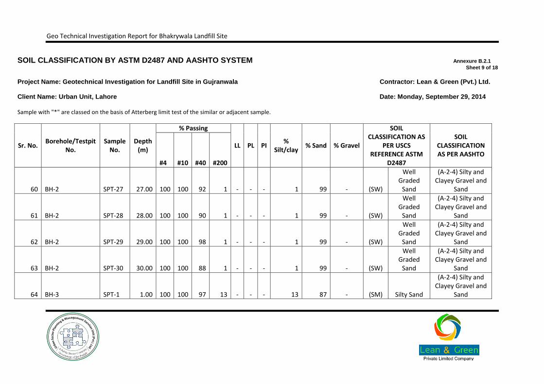
Geo Technical Investigation Report for Bhakrywala Landfill Site
SOIL CLASSIFICATION BY ASTM D2487 AND AASHTO SYSTEM Annexure B.2.1
Sheet 9 of 18
Project Name: Geotechnical Investigation for Landfill Site in Gujranwala Contractor: Lean & Green (Pvt.) Ltd.
Client Name: Urban Unit, Lahore Date: Monday, September 29, 2014
Sample with "*" are classed on the basis of Atterberg limit test of the similar or adjacent sample.
Sr. No. Borehole/Testpit
No. Sample
No. Depth
(m)
% Passing
LL PL PI %
Silt/clay % Sand % Gravel
SOIL CLASSIFICATION AS
PER USCS REFERENCE ASTM
D2487
SOIL CLASSIFICATION AS PER AASHTO
#4 #10 #40 #200
60 BH-2 SPT-27 27.00 100 100 92 1 - - - 1 99 - (SW)
Well Graded
Sand
(A-2-4) Silty and Clayey Gravel and
Sand
61 BH-2 SPT-28 28.00 100 100 90 1 - - - 1 99 - (SW)
Well Graded
Sand
(A-2-4) Silty and Clayey Gravel and
Sand
62 BH-2 SPT-29 29.00 100 100 98 1 - - - 1 99 - (SW)
Well Graded
Sand
(A-2-4) Silty and Clayey Gravel and
Sand
63 BH-2 SPT-30 30.00 100 100 88 1 - - - 1 99 - (SW)
Well Graded
Sand
(A-2-4) Silty and Clayey Gravel and
Sand
64 BH-3 SPT-1 1.00 100 100 97 13 - - - 13 87 - (SM) Silty Sand
(A-2-4) Silty and Clayey Gravel and
Sand

Geo Technical Investigation Report for Bhakrywala Landfill Site
65 BH-3 SPT-2 2.00 100 100 90 1 - - - 1 99 - (SW)
Well Graded
Sand
(A-2-4) Silty and Clayey Gravel and
Sand
66 BH-3 SPT-3 3.00 100 100 88 1 - - - 1 99 - (SW)
Well Graded
Sand
(A-2-4) Silty and Clayey Gravel and
Sand
Geo Technical Investigation Report for Bhakrywala Landfill Site
SOIL CLASSIFICATION BY ASTM D2487 AND AASHTO SYSTEM Annexure B.2.1
Sheet 10 of 18
Project Name: Geotechnical Investigation for Landfill Site in Gujranwala Contractor: Lean & Green (Pvt.) Ltd.
Client Name: Urban Unit, Lahore Date: Monday, September 29, 2014
Sample with "*" are classed on the basis of Atterberg limit test of the similar or adjacent sample.
Sr. No. Borehole/Testpit
No. Sample
No. Depth
(m)
% Passing
LL PL PI %
Silt/clay % Sand % Gravel
SOIL CLASSIFICATION AS PER USCS
REFERENCE ASTM D2487
SOIL CLASSIFICATION AS PER AASHTO
#4 #10 #40 #200
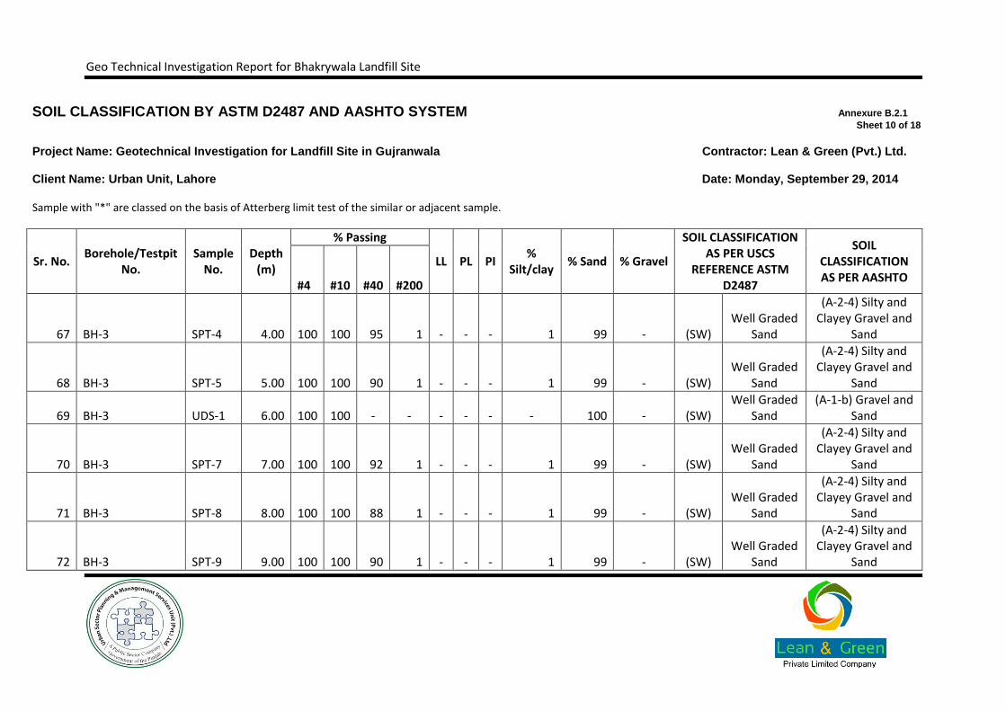
67 BH-3 SPT-4 4.00 100 100 95 1 - - - 1 99 - (SW) Well Graded
Sand
(A-2-4) Silty and Clayey Gravel and
Sand
68 BH-3 SPT-5 5.00 100 100 90 1 - - - 1 99 - (SW) Well Graded
Sand
(A-2-4) Silty and Clayey Gravel and
Sand
69 BH-3 UDS-1 6.00 100 100 - - - - - - 100 - (SW) Well Graded
Sand (A-1-b) Gravel and
Sand
70 BH-3 SPT-7 7.00 100 100 92 1 - - - 1 99 - (SW) Well Graded
Sand
(A-2-4) Silty and Clayey Gravel and
Sand
71 BH-3 SPT-8 8.00 100 100 88 1 - - - 1 99 - (SW) Well Graded
Sand
(A-2-4) Silty and Clayey Gravel and
Sand
72 BH-3 SPT-9 9.00 100 100 90 1 - - - 1 99 - (SW) Well Graded
Sand
(A-2-4) Silty and Clayey Gravel and
Sand
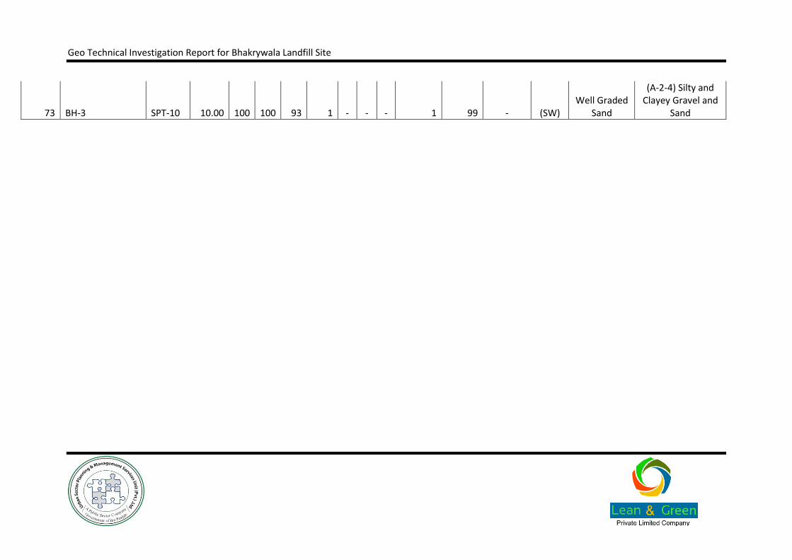
Geo Technical Investigation Report for Bhakrywala Landfill Site
73 BH-3 SPT-10 10.00 100 100 93 1 - - - 1 99 - (SW) Well Graded
Sand
(A-2-4) Silty and Clayey Gravel and
Sand

Geo Technical Investigation Report for Bhakrywala Landfill Site
SOIL CLASSIFICATION BY ASTM D2487 AND AASHTO SYSTEM Annexure B.2.1
Sheet 11 of 18
Project Name: Geotechnical Investigation for Landfill Site in Gujranwala Contractor: Lean & Green (Pvt.) Ltd.
Client Name: Urban Unit, Lahore Date: Monday, September 29, 2014
Sample with "*" are classed on the basis of Atterberg limit test of the similar or adjacent sample.
Sr. No. Borehole/Testpit
No. Sample
No. Depth
(m)
% Passing
LL PL PI %
Silt/clay % Sand % Gravel
SOIL CLASSIFICATION AS
PER USCS REFERENCE ASTM
D2487
SOIL CLASSIFICATION AS PER AASHTO
#4 #10 #40 #200
74 BH-3 SPT-11 11.00 100 100 90 1 - - - 1 99 - (SW) Well Graded
Sand
(A-2-4) Silty and Clayey Gravel and
Sand
75 BH-3 SPT-12 12.00 100 100 88 1 - - - 1 99 - (SW) Well Graded
Sand
(A-2-4) Silty and Clayey Gravel and
Sand
76 BH-3 SPT-13 13.00 100 100 87 1 - - - 1 99 - (SW) Well Graded
Sand
(A-2-4) Silty and Clayey Gravel and
Sand
77 BH-3 SPT-14 14.00 100 100 91 1 - - - 1 99 - (SW) Well Graded
Sand
(A-2-4) Silty and Clayey Gravel and
Sand
78 BH-3 SPT-15 15.00 100 100 88 1 - - - 1 99 - (SW) Well Graded
Sand
(A-2-4) Silty and Clayey Gravel and
Sand

Geo Technical Investigation Report for Bhakrywala Landfill Site
79 BH-3 SPT-16 16.00 100 100 85 1 - - - 1 99 - (SW) Well Graded
Sand
(A-2-4) Silty and Clayey Gravel and
Sand
80 BH-3 SPT-17 17.00 100 100 83 1 - - - 1 99 - (SW) Well Graded
Sand
(A-2-4) Silty and Clayey Gravel and
Sand
Geo Technical Investigation Report for Bhakrywala Landfill Site
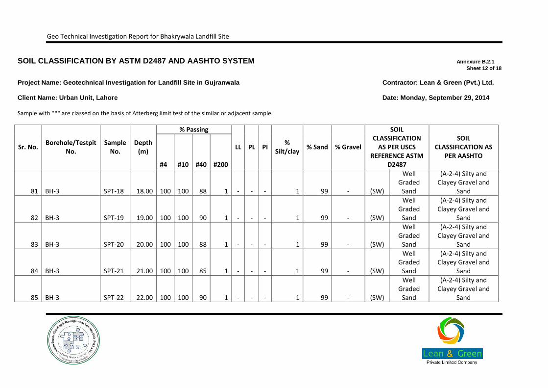
SOIL CLASSIFICATION BY ASTM D2487 AND AASHTO SYSTEM Annexure B.2.1
Sheet 12 of 18
Project Name: Geotechnical Investigation for Landfill Site in Gujranwala Contractor: Lean & Green (Pvt.) Ltd.
Client Name: Urban Unit, Lahore Date: Monday, September 29, 2014
Sample with "*" are classed on the basis of Atterberg limit test of the similar or adjacent sample.
Sr. No. Borehole/Testpit
No. Sample
No. Depth
(m)
% Passing
LL PL PI %
Silt/clay % Sand % Gravel
SOIL CLASSIFICATION
AS PER USCS REFERENCE ASTM
D2487
SOIL CLASSIFICATION AS
PER AASHTO #4 #10 #40 #200
81 BH-3 SPT-18 18.00 100 100 88 1 - - - 1 99 - (SW)
Well Graded
Sand
(A-2-4) Silty and Clayey Gravel and
Sand
82 BH-3 SPT-19 19.00 100 100 90 1 - - - 1 99 - (SW)
Well Graded
Sand
(A-2-4) Silty and Clayey Gravel and
Sand
83 BH-3 SPT-20 20.00 100 100 88 1 - - - 1 99 - (SW)
Well Graded
Sand
(A-2-4) Silty and Clayey Gravel and
Sand
84 BH-3 SPT-21 21.00 100 100 85 1 - - - 1 99 - (SW)
Well Graded
Sand
(A-2-4) Silty and Clayey Gravel and
Sand
85 BH-3 SPT-22 22.00 100 100 90 1 - - - 1 99 - (SW)
Well Graded
Sand
(A-2-4) Silty and Clayey Gravel and
Sand

Geo Technical Investigation Report for Bhakrywala Landfill Site
86 BH-3 SPT-23 23.00 100 100 87 1 - - - 1 99 - (SW)
Well Graded
Sand
(A-2-4) Silty and Clayey Gravel and
Sand
87 BH-3 SPT-24 24.00 100 100 86 1 - - - 1 99 - (SW)
Well Graded
Sand
(A-2-4) Silty and Clayey Gravel and
Sand

Geo Technical Investigation Report for Bhakrywala Landfill Site
SOIL CLASSIFICATION BY ASTM D2487 AND AASHTO SYSTEM Annexure B.2.1
Sheet 13 of 18
Project Name: Geotechnical Investigation for Landfill Site in Gujranwala Contractor: Lean & Green (Pvt.) Ltd.
Client Name: Urban Unit, Lahore Date: Monday, September 29, 2014
Sample with "*" are classed on the basis of Atterberg limit test of the similar or adjacent sample.
Sr. No. Borehole/Testpit
No. Sample
No. Depth
(m)
% Passing
LL PL PI %
Silt/clay % Sand % Gravel
SOIL CLASSIFICATION AS PER USCS
REFERENCE ASTM D2487
SOIL CLASSIFICATION AS PER AASHTO
#4 #10 #40 #200
88 BH-3 SPT-25 25.00 100 100 85 1 - - - 1 99 - (SW) Well Graded
Sand
(A-2-4) Silty and Clayey Gravel and
Sand
89 BH-3 SPT-26 26.00 100 100 90 1 - - - 1 99 - (SW) Well Graded
Sand
(A-2-4) Silty and Clayey Gravel and
Sand
90 BH-3 SPT-27 27.00 100 100 88 1 - - - 1 99 - (SW) Well Graded
Sand
(A-2-4) Silty and Clayey Gravel and
Sand
91 BH-3 SPT-28 28.00 100 100 87 1 - - - 1 99 - (SW) Well Graded
Sand
(A-2-4) Silty and Clayey Gravel and
Sand
92 BH-3 SPT-29 29.00 100 100 90 1 - - - 1 99 - (SW) Well Graded
Sand
(A-2-4) Silty and Clayey Gravel and
Sand

Geo Technical Investigation Report for Bhakrywala Landfill Site
93 BH-3 SPT-30 30.00 100 100 85 1 - - - 1 99 - (SW) Well Graded
Sand
(A-2-4) Silty and Clayey Gravel and
Sand
94 BH-4 SPT-1 1.00 100 100 90 3 - - - 3 97 - (SW) Well Graded
Sand
(A-2-4) Silty and Clayey Gravel and
Sand

Geo Technical Investigation Report for Bhakrywala Landfill Site
SOIL CLASSIFICATION BY ASTM D2487 AND AASHTO SYSTEM Annexure B.2.1
Sheet 14 of 18
Project Name: Geotechnical Investigation for Landfill Site in Gujranwala Contractor: Lean & Green (Pvt.) Ltd.
Client Name: Urban Unit, Lahore Date: Monday, September 29, 2014
Sample with "*" are classed on the basis of Atterberg limit test of the similar or adjacent sample.
Sr. No. Borehole/Testpit
No. Sample
No. Depth
(m)
% Passing
LL PL PI %
Silt/clay % Sand % Gravel
SOIL CLASSIFICATION AS PER USCS
REFERENCE ASTM D2487
SOIL CLASSIFICATION AS PER AASHTO
#4 #10 #40 #200
95 BH-4 SPT-2 2.00 100 100 88 2 - - - 2 98 - (SW) Well Graded
Sand
(A-2-4) Silty and Clayey Gravel and
Sand
96 BH-4 SPT-3 3.00 100 100 85 1 - - - 1 99 - (SW) Well Graded
Sand
(A-2-4) Silty and Clayey Gravel and
Sand
97 BH-4 SPT-4 4.00 100 100 82 1 - - - 1 99 - (SW) Well Graded
Sand
(A-2-4) Silty and Clayey Gravel and
Sand
98 BH-4 SPT-5 5.00 100 100 80 1 - - - 1 99 - (SW) Well Graded
Sand
(A-2-4) Silty and Clayey Gravel and
Sand
99 BH-4 SPT-6 6.00 100 100 85 1 - - - 1 99 - (SW) Well Graded
Sand
(A-2-4) Silty and Clayey Gravel and
Sand
Geo Technical Investigation Report for Bhakrywala Landfill Site
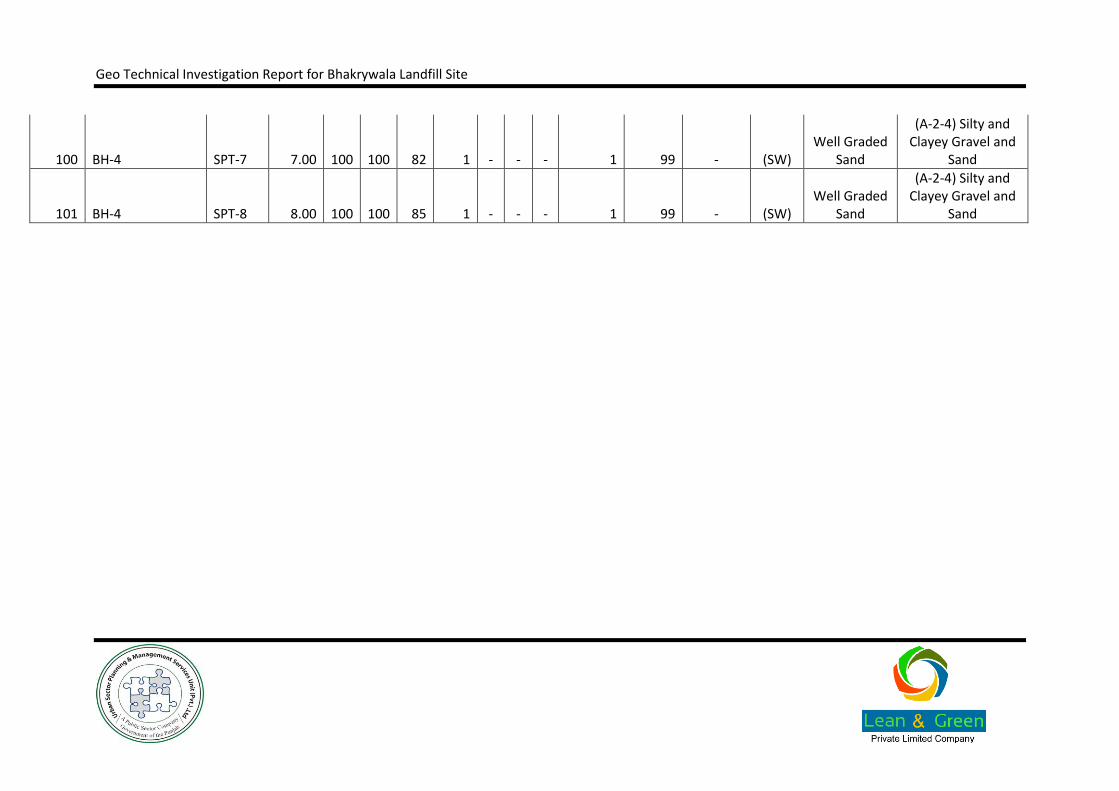
100 BH-4 SPT-7 7.00 100 100 82 1 - - - 1 99 - (SW) Well Graded
Sand
(A-2-4) Silty and Clayey Gravel and
Sand
101 BH-4 SPT-8 8.00 100 100 85 1 - - - 1 99 - (SW) Well Graded
Sand
(A-2-4) Silty and Clayey Gravel and
Sand
Geo Technical Investigation Report for Bhakrywala Landfill Site
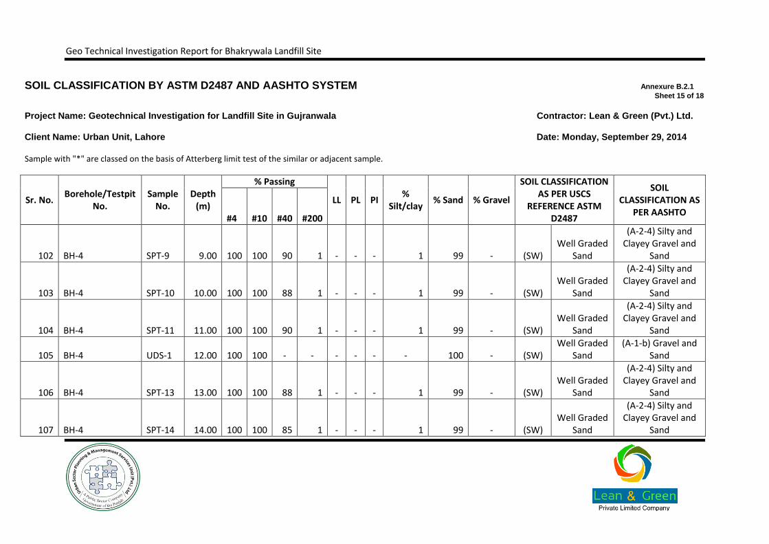
SOIL CLASSIFICATION BY ASTM D2487 AND AASHTO SYSTEM Annexure B.2.1
Sheet 15 of 18
Project Name: Geotechnical Investigation for Landfill Site in Gujranwala Contractor: Lean & Green (Pvt.) Ltd.
Client Name: Urban Unit, Lahore Date: Monday, September 29, 2014
Sample with "*" are classed on the basis of Atterberg limit test of the similar or adjacent sample.
Sr. No. Borehole/Testpit
No. Sample
No. Depth
(m)
% Passing
LL PL PI %
Silt/clay % Sand % Gravel
SOIL CLASSIFICATION AS PER USCS
REFERENCE ASTM D2487
SOIL CLASSIFICATION AS
PER AASHTO #4 #10 #40 #200
102 BH-4 SPT-9 9.00 100 100 90 1 - - - 1 99 - (SW) Well Graded
Sand
(A-2-4) Silty and Clayey Gravel and
Sand
103 BH-4 SPT-10 10.00 100 100 88 1 - - - 1 99 - (SW) Well Graded
Sand
(A-2-4) Silty and Clayey Gravel and
Sand
104 BH-4 SPT-11 11.00 100 100 90 1 - - - 1 99 - (SW) Well Graded
Sand
(A-2-4) Silty and Clayey Gravel and
Sand
105 BH-4 UDS-1 12.00 100 100 - - - - - - 100 - (SW) Well Graded
Sand (A-1-b) Gravel and
Sand
106 BH-4 SPT-13 13.00 100 100 88 1 - - - 1 99 - (SW) Well Graded
Sand
(A-2-4) Silty and Clayey Gravel and
Sand
107 BH-4 SPT-14 14.00 100 100 85 1 - - - 1 99 - (SW) Well Graded
Sand
(A-2-4) Silty and Clayey Gravel and
Sand

Geo Technical Investigation Report for Bhakrywala Landfill Site
108 BH-4 SPT-15 15.00 100 100 82 1 - - - 1 99 - (SW) Well Graded
Sand
(A-2-4) Silty and Clayey Gravel and
Sand

Geo Technical Investigation Report for Bhakrywala Landfill Site
SOIL CLASSIFICATION BY ASTM D2487 AND AASHTO SYSTEM Annexure B.2.1
Sheet 16 of 18
Project Name: Geotechnical Investigation for Landfill Site in Gujranwala Contractor: Lean & Green (Pvt.) Ltd.
Client Name: Urban Unit, Lahore Date: Monday, September 29, 2014
Sample with "*" are classed on the basis of Atterberg limit test of the similar or adjacent sample.
Sr. No. Borehole/Testpit
No. Sample
No. Depth
(m)
% Passing
LL PL PI %
Silt/clay % Sand % Gravel
SOIL CLASSIFICATION AS PER USCS
REFERENCE ASTM D2487
SOIL CLASSIFICATION AS
PER AASHTO #4 #10 #40 #200
109 BH-4 SPT-16 16.00 100 100 85 1 - - - 1 99 - (SW) Well Graded
Sand
(A-2-4) Silty and Clayey Gravel and
Sand
110 BH-4 SPT-17 17.00 100 100 80 1 - - - 1 99 - (SW) Well Graded
Sand
(A-2-4) Silty and Clayey Gravel and
Sand
111 BH-4 SPT-18 18.00 100 100 88 1 - - - 1 99 - (SW) Well Graded
Sand
(A-2-4) Silty and Clayey Gravel and
Sand
112 BH-4 SPT-19 19.00 100 100 90 1 - - - 1 99 - (SW) Well Graded
Sand
(A-2-4) Silty and Clayey Gravel and
Sand
113 BH-4 SPT-20 20.00 100 100 89 1 - - - 1 99 - (SW) Well Graded
Sand
(A-2-4) Silty and Clayey Gravel and
Sand

Geo Technical Investigation Report for Bhakrywala Landfill Site
114 BH-4 SPT-21 21.00 100 100 90 1 - - - 1 99 - (SW) Well Graded
Sand
(A-2-4) Silty and Clayey Gravel and
Sand
115 BH-4 SPT-22 22.00 100 100 88 1 - - - 1 99 - (SW) Well Graded
Sand
(A-2-4) Silty and Clayey Gravel and
Sand
Geo Technical Investigation Report for Bhakrywala Landfill Site
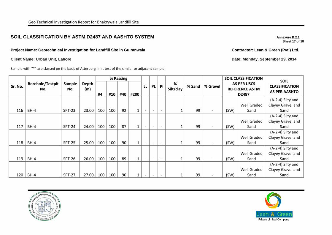
SOIL CLASSIFICATION BY ASTM D2487 AND AASHTO SYSTEM Annexure B.2.1
Sheet 17 of 18
Project Name: Geotechnical Investigation for Landfill Site in Gujranwala Contractor: Lean & Green (Pvt.) Ltd.
Client Name: Urban Unit, Lahore Date: Monday, September 29, 2014
Sample with "*" are classed on the basis of Atterberg limit test of the similar or adjacent sample.
Sr. No. Borehole/Testpit
No. Sample
No. Depth
(m)
% Passing
LL PL PI %
Silt/clay % Sand % Gravel
SOIL CLASSIFICATION AS PER USCS
REFERENCE ASTM D2487
SOIL CLASSIFICATION AS PER AASHTO
#4 #10 #40 #200
116 BH-4 SPT-23 23.00 100 100 92 1 - - - 1 99 - (SW) Well Graded
Sand
(A-2-4) Silty and Clayey Gravel and
Sand
117 BH-4 SPT-24 24.00 100 100 87 1 - - - 1 99 - (SW) Well Graded
Sand
(A-2-4) Silty and Clayey Gravel and
Sand
118 BH-4 SPT-25 25.00 100 100 90 1 - - - 1 99 - (SW) Well Graded
Sand
(A-2-4) Silty and Clayey Gravel and
Sand
119 BH-4 SPT-26 26.00 100 100 89 1 - - - 1 99 - (SW) Well Graded
Sand
(A-2-4) Silty and Clayey Gravel and
Sand
120 BH-4 SPT-27 27.00 100 100 90 1 - - - 1 99 - (SW) Well Graded
Sand
(A-2-4) Silty and Clayey Gravel and
Sand

Geo Technical Investigation Report for Bhakrywala Landfill Site
121 BH-4 SPT-28 28.00 100 100 88 1 - - - 1 99 - (SW) Well Graded
Sand
(A-2-4) Silty and Clayey Gravel and
Sand
122 BH-4 SPT-29 29.00 100 100 87 1 - - - 1 99 - (SW) Well Graded
Sand
(A-2-4) Silty and Clayey Gravel and
Sand
Geo Technical Investigation Report for Bhakrywala Landfill Site
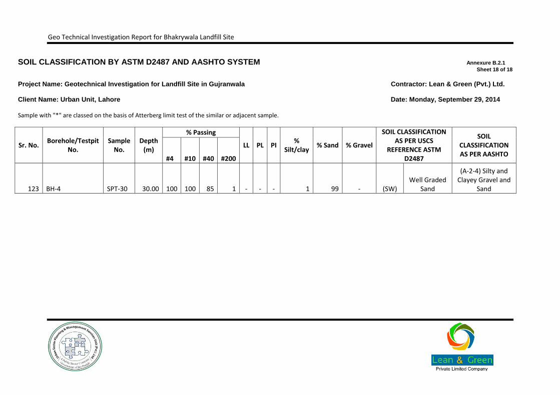
SOIL CLASSIFICATION BY ASTM D2487 AND AASHTO SYSTEM Annexure B.2.1
Sheet 18 of 18
Project Name: Geotechnical Investigation for Landfill Site in Gujranwala Contractor: Lean & Green (Pvt.) Ltd.
Client Name: Urban Unit, Lahore Date: Monday, September 29, 2014
Sample with "*" are classed on the basis of Atterberg limit test of the similar or adjacent sample.
Sr. No. Borehole/Testpit
No. Sample
No. Depth
(m)
% Passing
LL PL PI %
Silt/clay % Sand % Gravel
SOIL CLASSIFICATION AS PER USCS
REFERENCE ASTM D2487
SOIL CLASSIFICATION AS PER AASHTO
#4 #10 #40 #200
123 BH-4 SPT-30 30.00 100 100 85 1 - - - 1 99 - (SW) Well Graded
Sand
(A-2-4) Silty and Clayey Gravel and
Sand

Geo Technical Investigation Report for Bhakrywala Landfill Site
SUMMARY OF CHEMICAL TEST RESULTS PERFORMED ON SOIL/WATER SAMPLES Annexure B.2.3
Sheet 2 of 2
Project Name: Geotechnical Investigation for Landfill Site in Gujranwala Contractor: Lean & Green (Pvt.) Ltd.
Client Name: Urban Unit, Lahore Date: Monday, September 29, 2014
Sr. No. Borehole/Testpit No.
Sample No. Depth (m) Organic Matter
Content (%) Sulphate Contents
(%) Chloride Contents
(%) PH TDS (PPM)
1 BH-1 WS - - - 0.092 - 445.000
2 BH-2 WS - - - 0.098 - 460.000
3 BH-3 WS - - - 0.089 - 435.000
4 BH-4 WS - - - 0.067 - 355.000
Geo Technical Investigation Report for Bhakrywala Landfill Site
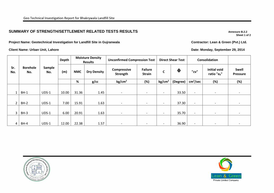
B.2.2. Summary of Strength Related Test Results
Geo Technical Investigation Report for Bhakrywala Landfill Site
SUMMARY OF STRENGTH/SETTLEMENT RELATED TESTS RESULTS Annexure B.2.2
Sheet 1 of 2
Project Name: Geotechnical Investigation for Landfill Site in Gujranwala Contractor: Lean & Green (Pvt.) Ltd.
Client Name: Urban Unit, Lahore Date: Monday, September 29, 2014
Sr. No.
Borehole No.
Sample No.
Depth Moisture Density
Results Unconfirmed Compression Test Direct Shear Test Consolidation
(m) NMC Dry Density Compressive
Strength Failure Strain
C ᶲ "cv" initial void ratio "e0"
Swell Pressure
% g/cc kg/cm2 (%) kg/cm2 (Degree) cm2/sec (%) (%)
1 BH-1 UDS-1 10.00 31.36 1.45 - - - 33.50 - - -
2 BH-2 UDS-1 7.00 15.91 1.63 - - - 37.30 - - -
3 BH-3 UDS-1 6.00 20.91 1.63 - - - 35.70 - - -
4 BH-4 UDS-1 12.00 22.38 1.57 - - - 36.90 - - -

Geo Technical Investigation Report for Bhakrywala Landfill Site
B.3. Allowable Bearing Capacity Curve
Geo Technical Investigation Report for Bhakrywala Landfill Site
B.3.1. Square/Rectangular Foundation
Geo Technical Investigation Report for Bhakrywala Landfill Site

Geo Technical Investigation Report for Bhakrywala Landfill Site
Geo Technical Investigation Report for Bhakrywala Landfill Site
B.3.2. Strip Foundation

Geo Technical Investigation Report for Bhakrywala Landfill Site
Geo Technical Investigation Report for Bhakrywala Landfill Site
Annexure C. Field Permeability Test Data
Geo Technical Investigation Report for Bhakrywala Landfill Site
Geo Technical Investigation Report for Bhakrywala Landfill Site

Geo Technical Investigation Report for Bhakrywala Landfill Site
Geo Technical Investigation Report for Bhakrywala Landfill Site

Geo Technical Investigation Report for Bhakrywala Landfill Site
Geo Technical Investigation Report for Bhakrywala Landfill Site
Annexure D. Site Investigation Logs

Geo Technical Investigation Report for Bhakrywala Landfill Site
D.1. Borehole Logs
Geo Technical Investigation Report for Bhakrywala Landfill Site
Geo Technical Investigation Report for Bhakrywala Landfill Site

Geo Technical Investigation Report for Bhakrywala Landfill Site

Geo Technical Investigation Report for Bhakrywala Landfill Site

Geo Technical Investigation Report for Bhakrywala Landfill Site
Geo Technical Investigation Report for Bhakrywala Landfill Site

Geo Technical Investigation Report for Bhakrywala Landfill Site

Geo Technical Investigation Report for Bhakrywala Landfill Site

Geo Technical Investigation Report for Bhakrywala Landfill Site

Geo Technical Investigation Report for Bhakrywala Landfill Site
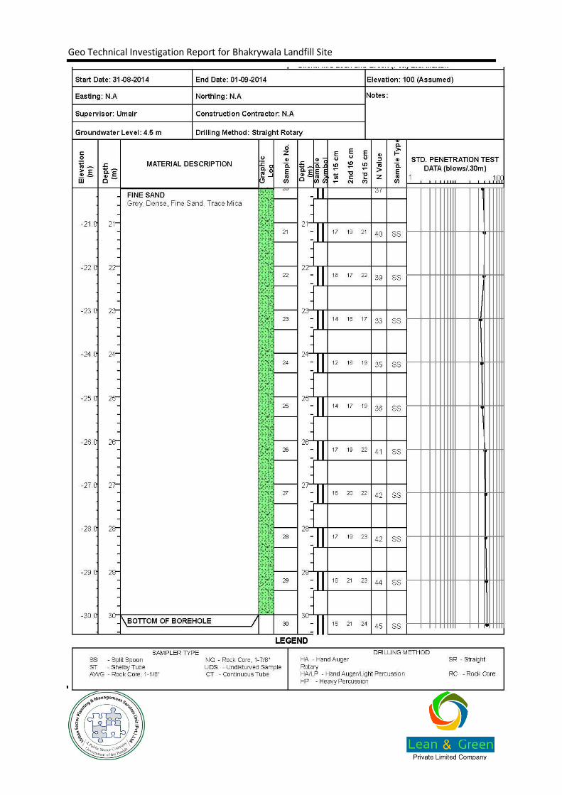
Geo Technical Investigation Report for Bhakrywala Landfill Site

Geo Technical Investigation Report for Bhakrywala Landfill Site
Annexure E. Site Photographs
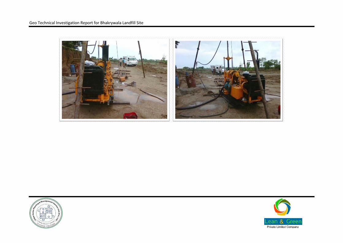
Geo Technical Investigation Report for Bhakrywala Landfill Site

Geo Technical Investigation Report for Bhakrywala Landfill Site

Geo Technical Investigation Report for Bhakrywala Landfill Site
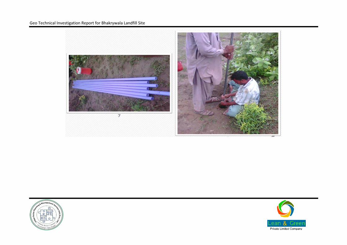
Geo Technical Investigation Report for Bhakrywala Landfill Site

Geo Technical Investigation Report for Bhakrywala Landfill Site
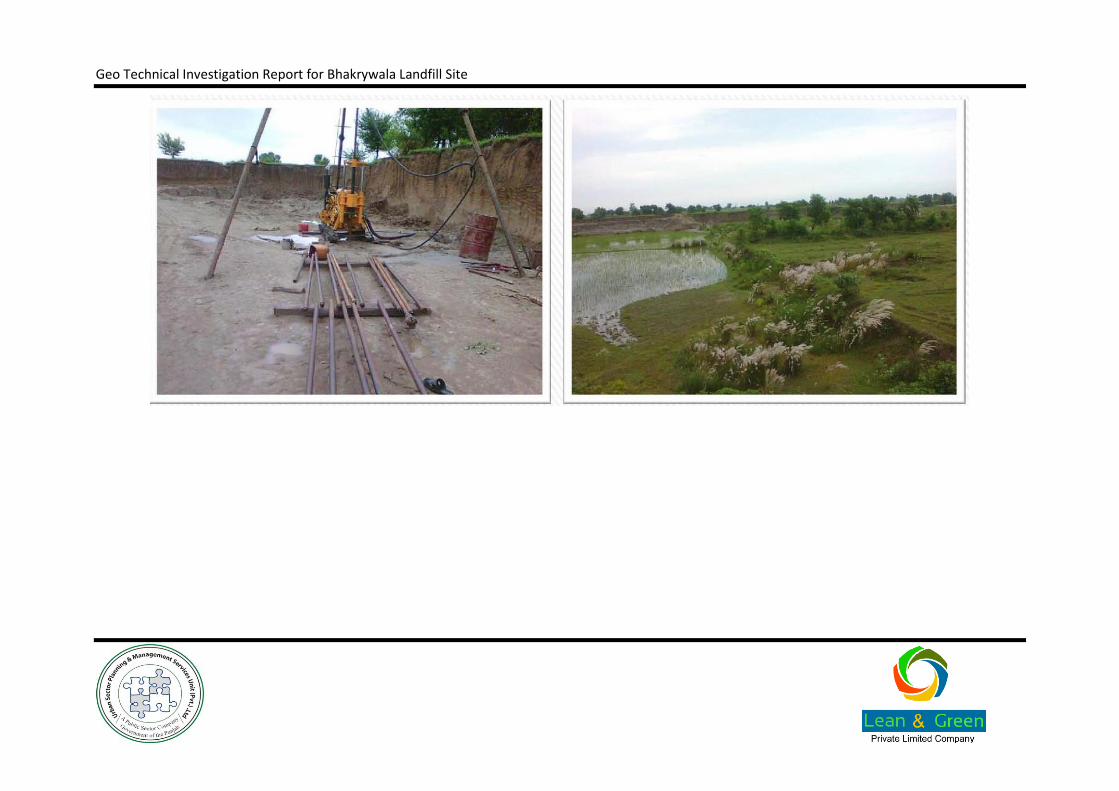
Geo Technical Investigation Report for Bhakrywala Landfill Site
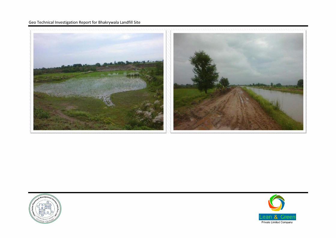
Geo Technical Investigation Report for Bhakrywala Landfill Site
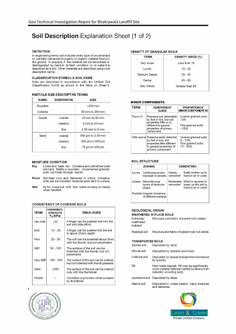
Geo Technical Investigation Report for Bhakrywala Landfill Site
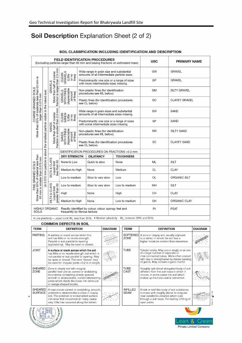
Geo Technical Investigation Report for Bhakrywala Landfill Site