Embed Size (px)
Citation preview
KENNECOTT GREENS CREEK MINING COMPANY
GENERAL PLAN OF OPERATIONS
APPENDIX 14
RECLAMATION PLAN
Date:October 2000
Reclamation PlanOctober 2000
Page ii
TABLE OF CONTENTS
1. Introduction .........................................................................................................1-1
1.1. Purpose and Scope of Reclamation Plan ..........................................................1-1
1.2. Site History ........................................................................................................1-1
1.3. Post-Mining Land Use and Ownership ..............................................................1-1
1.4. Agency Requirements .......................................................................................1-11.4.1. United States Forest Service ..............................................................................................................1-11.4.2. Alaska Department of Environmental Conservation..........................................................................1-71.4.3. Alaska Department of Natural Resources ..........................................................................................1-8
1.5. Plan Objectives................................................................................................1-10
1.6. Reclamation Schedule.....................................................................................1-111.6.1. Interim Reclamation.........................................................................................................................1-111.6.2. Concurrent Reclamation ..................................................................................................................1-121.6.3. Temporary Cessation .......................................................................................................................1-131.6.4. Final Reclamation............................................................................................................................1-131.6.5. Post-Closure Care and Maintenance ...............................................................................................1-14
1.7. Detailed Plan Submission and Approval..........................................................1-14
1.8. Final Reclamation Plan and Monitoring/Contingency Plan ..............................1-15
1.9. Bond Cost Calculation and Bond Release.......................................................1-151.9.1. Incremental Bond Release................................................................................................................1-151.9.2. Bonding and Management During Post-Closure Care Period ........................................................1-161.9.3. Final Bond Release ..........................................................................................................................1-17
1.10. Reporting ..................................................................................................1-17
2. Performance Goals ...........................................................................................2-18
2.1 Water Quality...................................................................................................2-182.1.1. Monitoring Requirements.................................................................................................................2-182.1.2. Waiver or Modification ....................................................................................................................2-182.1.3. Performance Standards and Point of Compliance...........................................................................2-192.1.4. Contact Water Management.............................................................................................................2-20
2.2. Demolition........................................................................................................2-212.2.1. Solid Waste.......................................................................................................................................2-21
Reclamation PlanOctober 2000
Page iii
2.2.2. Hazardous Materials........................................................................................................................2-21
2.3. Land Use/Vegetation .......................................................................................2-212.3.1. Roads and Site Access......................................................................................................................2-212.3.2. Aesthetics .........................................................................................................................................2-222.3.3. Revegetation.....................................................................................................................................2-222.3.4. Wildlife Use......................................................................................................................................2-25
2.4. Stability ............................................................................................................2-262.4.1. Mass Instability ................................................................................................................................2-262.4.2. Permanent Channels and Channel Inspection .................................................................................2-272.4.3. Drainage ..........................................................................................................................................2-282.4.4. Cover Performance and Inspection..................................................................................................2-292.4.5. Erosion .............................................................................................................................................2-31
3. Attachment A: Reclamation Plan .......................................................................3-1
Reclamation PlanOctober 2000
Page iv
LIST OF TABLES
Table 1-1. General Forest Service reclamation requirements. 1-2
Table 1-2. Monument-specific Forest Service reclamation requirements. 1-5
Table 1-3. Tongass Forest specific Forest Service reclamation requirements. 1-6
Table 1-4. NEPA reclamation requirements. 1-6
Table 1-5. Reclamation requirements of the Alaska Mine Reclamation Act. 1-9
LIST OF FIGURES
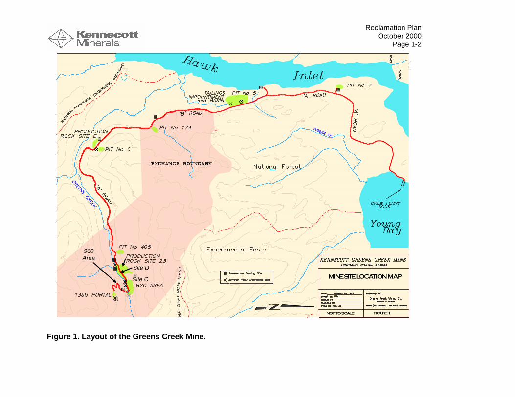
Figure 1. Layout of the Greens Creek Mine. 1-2
Reclamation PlanOctober 2000
Page 1-1
1. Introduction
1.1. Purpose and Scope of Reclamation Plan
The Kennecott Greens Creek Mining Company (KGCMC) reclamation plan is designedto return the mine to a near-natural condition as contemplated in the FinalEnvironmental Impact Statement (FEIS). Additionally, the goal of this plan is toimplement concurrent reclamation, as appropriate, to minimize the effects ofdisturbance while mining within Admiralty National Monument (Monument). Also, thereclamation plan is designed to meet the Forest Service Manual’s definition ofreclamation: “Those actions performed during or after mineral activities to shape,stabilize, revegetate, or otherwise treat the affected lands in order to achieve a safe andecologically stable condition and land use that is consistent with long-term forest landand resource management plans and local environmental conditions.” Additionally, thereclamation plan is designed to fulfill the requirements of the State of Alaska forfacilities over which they have jurisdiction through the Alaska Department ofEnvironmental Conservation (ADEC) including the Solid Waste Management Programand other regulatory initiatives, and the Reclamation Act administered by the AlaskaDepartment of Natural Resources (ADNR). Finally, the plan addresses therequirements of the US Army Corps of Engineers (COE) and the City and Borough ofJuneau (CBJ).
This reclamation plan sets performance goals applicable to interim, concurrent and finalreclamation, and addresses post-closure monitoring requirements. It also setsscheduling and other standards for reclamation and for final closure planningrequirements, and it explains how detailed, regularly-updated reclamation task planningwill be used for purposes of calculating a reclamation bond.
1.2. Site History
Kennecott Greens Creek Mining Company (KGCMC) began operating a mine/millcomplex in the upper Greens Creek drainage of northern Admiralty Island in February1989. The production startup was the culmination of approximately two years ofintense development and construction following a 10-year permitting effort. In 1993 themine suspended operations primarily because of low metal prices. Operations restartedin 1996 following extensive feasibility studies, recovered metal prices, and site-widereconstruction efforts. The facility design as it is currently permitted and operated isshown in Figure 1.
Reclamation PlanOctober 2000
Page 1-2
Figure 1. Layout of the Greens Creek Mine.
FIGURE 1
MINE SITE LOCATION MAP
NOT TO SCALE
Site D
Site C
960Area

Reclamation PlanOctober 2000
Page 1-1
1.3. Post-Mining Land Use and Ownership
The land comprising the Greens Creek mine, inclusive of all Admiralty Island facilities,consists of both publicly and privately owned uplands and tidelands. Greens Creekleases parcels from the United States on both the Monument and non-monumentlands. It uses other public lands pursuant to special use permits issued by the ForestService and leases issued by the State of Alaska. It owns land on Admiralty Island bothas a result of patenting mining and millsite claims and through transfer of private landsin the historic cannery area from its predecessor. Additionally, Greens Creek holdssubsurface and restricted surface use rights to approximately 7,300 acres of publiclands as a result of a land exchange made pursuant to the Greens Creek LandExchange Act of 1995 (Pub. L. 104-123 April 1, 1996).
Under the land exchange agreement, certain of the private lands (e.g. patented claims)owned by Greens Creek ultimately will be transferred to the United States and the7,300 acres of subsurface and restricted-use surface lands patented to Greens Creekin 1999 will revert to the United States. The land exchange agreement does not imposespecial reclamation requirements on these lands. It requires simply that they must bereclaimed in accordance with applicable laws and the approved reclamation plan.
Final reclamation of the mine facilities will take into account anticipated post-miningland uses. Since such uses likely will be limited primarily to monument-related activities,returning the surface to a near-natural condition should satisfy post-mining land useneeds as to most of the lands. Private lands that will retain their private status, if any,after mining were developed for non-monument uses prior to creation of the AdmiraltyIsland National Monument. After closure, Greens Creek will consult with the ultimatelandowner, as well as any agencies having regulatory authority over reclamation ofsuch lands, to determine the final disposition of structures and facilities then havingremaining useful life.
1.4. Agency Requirements
1.4.1. United States Forest ServiceThe Forest Service has numerous reclamation requirements for the Greens Creekmine. These requirements can be categorized as general Forest Service mining rules,Forest and Monument specific rules, and decisions reached through the NEPA process.These are discussed in Table 1.1 through 1.4, respectively.

Reclamation PlanOctober 2000
Page 1-2
Table 1-1. General Forest Service reclamation requirements.
General Forest Service Mine Reclamation Requirements
CODE OF FEDERAL REGULATIONSTITLE 36--PARKS, FORESTS, AND PUBLIC PROPERTYPART 228--MINERALS
Subpart A--Locatable Minerals
Sec. 228.8 …All operations shall be conducted so as, where feasible, to minimize adverse environmental impactson National Forest surface resources, including the following requirements:
(f) Roads. Operator shall construct and maintain all roads so as to assure adequate drainage and to minimize or,where practicable, eliminate damage to soil, water, and other resource values. Unless otherwise approved by theauthorized officer, roads no longer needed for operations:
(1) Shall be closed to normal vehicular traffic,
(2) Bridges and culverts shall be removed,
(3) Cross drains, dips, or water bars shall be constructed, and
(4) The road surface shall be shaped to as near a natural contour as practicable and be stabilized.
(g) Reclamation. Upon exhaustion of the mineral deposit or at the earliest practicable time during operations, orwithin 1 year of the conclusion of operations, unless a longer time is allowed by the authorized officer, operator shall,where practicable, reclaim the surface disturbed in operations by taking such measures as will prevent or controlonsite and off-site damage to the environment and forest surface resources including:
(1) Control of erosion and landslides;
(2) Control of water runoff;
(3) Isolation, removal or control of toxic materials;
(4) Reshaping and revegetation of disturbed areas, where reasonably practicable; and
(5) Rehabilitation of fisheries and wildlife habitat.
(h) Certification or other approval issued by State agencies or other Federal agencies of compliance with laws andregulations relating to mining operations will be accepted as compliance with similar or parallel requirements ofthese regulations.
Sec. 228.10 …Unless otherwise agreed to by the authorized officer, operator shall remove within a reasonable timefollowing cessation of operations all structures, equipment and other facilities and clean up the site of operations...
Sec. 228.13
(a) Any operator required to file a plan of operations shall, when required by the authorized officer, furnish a bondconditioned upon compliance with Sec. 228.8(g), prior to approval of such plan of operations. In lieu of a bond, theoperator may deposit into a Federal depository, as directed by the Forest Service, and maintain therein, cash in anamount equal to the required dollar amount of the bond or negotiable securities of the United States having marketvalue at the time of deposit of not less than the required dollar amount of the bond. A blanket bond coveringnationwide or statewide operations may be furnished if the terms and conditions thereof are sufficient to comply withthe regulations in this part.
(b) In determining the amount of the bond, consideration will be given to the estimated cost of stabilizing,rehabilitating, and reclaiming the area of operations.
(c) In the event that an approved plan of operations is modified in accordance with Sec. 228.4 (d) and (e), theauthorized officer will review the initial bond for adequacy and, if necessary, will adjust the bond to conform to theoperations plan as modified.
(d) When reclamation has been completed in accordance with Sec. 228.8(g), the authorized officer will notify theoperator that performance under the bond has been completed: Provided, however, That when the Forest Service
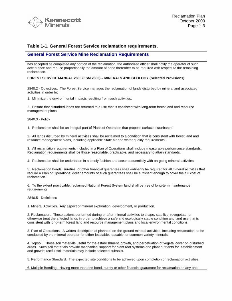
Reclamation PlanOctober 2000
Page 1-3
Table 1-1. General Forest Service reclamation requirements.
General Forest Service Mine Reclamation Requirements
has accepted as completed any portion of the reclamation, the authorized officer shall notify the operator of suchacceptance and reduce proportionally the amount of bond thereafter to be required with respect to the remainingreclamation.
FOREST SERVICE MANUAL 2800 (FSM 2800) – MINERALS AND GEOLOGY (Selected Provisions)
2840.2 - Objectives. The Forest Service manages the reclamation of lands disturbed by mineral and associatedactivities in order to:
1. Minimize the environmental impacts resulting from such activities.
2. Ensure that disturbed lands are returned to a use that is consistent with long-term forest land and resourcemanagement plans.
2840.3 - Policy
1. Reclamation shall be an integral part of Plans of Operation that propose surface disturbance.
2. All lands disturbed by mineral activities shall be reclaimed to a condition that is consistent with forest land andresource management plans, including applicable State air and water quality requirements.
3. All reclamation requirements included in a Plan of Operations shall include measurable performance standards.Reclamation requirements shall be those reasonable, practicable, and necessary to attain standards.
4. Reclamation shall be undertaken in a timely fashion and occur sequentially with on-going mineral activities.
5. Reclamation bonds, sureties, or other financial guarantees shall ordinarily be required for all mineral activities thatrequire a Plan of Operations; dollar amounts of such guarantees shall be sufficient enough to cover the full cost ofreclamation.
6. To the extent practicable, reclaimed National Forest System land shall be free of long-term maintenancerequirements.
2840.5 - Definitions
1. Mineral Activities. Any aspect of mineral exploration, development, or production.
2. Reclamation. Those actions performed during or after mineral activities to shape, stabilize, revegetate, orotherwise treat the affected lands in order to achieve a safe and ecologically stable condition and land use that isconsistent with long-term forest land and resource management plans and local environmental conditions.
3. Plan of Operations. A written description of planned, on-the-ground mineral activities, including reclamation, to beconducted by the mineral operator for either locatable, leasable, or common variety minerals.
4. Topsoil. Those soil materials useful for the establishment, growth, and perpetuation of vegetal cover on disturbedareas. Such soil materials provide mechanical support for plant root systems and plant nutrients for establishmentand growth; useful soil materials may include selected subsoils.
5. Performance Standard. The expected site conditions to be achieved upon completion of reclamation activities.
6. Multiple Bonding. Having more than one bond, surety or other financial guarantee for reclamation on any one
Reclamation PlanOctober 2000
Page 1-4
Table 1-1. General Forest Service reclamation requirements.
General Forest Service Mine Reclamation Requirements
mineral operation.
7. Excess Bonding. Where the total amount of bonds, sureties or other financial guarantees exceeds the cost ofreclamation.
8. Interim Shutdown. The cessation of mineral activities by the operator prior to the expected time described in thePlan of Operations.
9. Disturbed Area. The surface lands disturbed by mineral or associated activities.
2841 - RECLAMATION COMPONENTS FOR PLANS OF OPERATIONS. Forest Supervisors shall ensure thefollowing administrative and environmental components are adequately addressed in each Plan of Operations whenapplicable:
1. Administrative Components.
a. Timing, kind, and amount of reclamation to be accomplished concurrently with mineral activities.
b. Reclamation requirements for interim shutdown, including seasonal shutdown.
c. The maximum allowable time in the event of interim shutdown before final reclamation measures will be required.
d. Concurrent and final reclamation of transportation facilities, such as roads, railways, tramways, power linecorridors, and pipelines.
e. Removal of facilities and reclamation of the site.
f. Timeframes for periodic review and updating of the Plan of Operations, including reclamation performancerequirements and financial guarantees.
g. Procedures for ensuring interim and final stability of waste embankments, including dumps, tailings dams, orimpoundments.
2. Environmental Components.
a. Final configuration of the disturbed areas, including such items as roads, pits, waste embankments, ponds, leachpads, drill holes, and facility sites.
b. Revegetation of disturbed areas, including timing, kind, and amount.
c. Topsoil management, including soil salvage and reapplication (FSM 2550 and FSH 2509.15).
d. Air quality management during and after operations (FSM 2580 and FSH 2509.19).
e. Watershed management, including runoff and erosion control, and riparian and wetland protection (FSM 2520and FSH 2509.15).
f. Water quality management, including physical and chemical characteristics of surface and subsurface waterduring and after operations (FSM 2530 and FSH 2509.15).
Reclamation PlanOctober 2000
Page 1-5
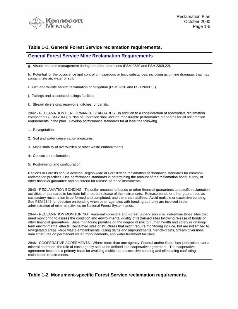
Table 1-1. General Forest Service reclamation requirements.
General Forest Service Mine Reclamation Requirements
g. Visual resource management during and after operations (FSM 2380 and FSH 2309.22).
h. Potential for the occurrence and control of hazardous or toxic substances, including acid mine drainage, that maycontaminate air, water or soil.
i. Fish and wildlife habitat reclamation or mitigation (FSM 2630 and FSH 2609.11).
j. Tailings and associated tailings facilities.
k. Stream diversions, reservoirs, ditches, or canals.
2842 - RECLAMATION PERFORMANCE STANDARDS. In addition to a consideration of appropriate reclamationcomponents (FSM 2841), a Plan of Operation shall include measurable performance standards for all reclamationrequirements in the plan. Develop performance standards for at least the following.
1. Revegetation.
2. Soil and water conservation measures.
3. Mass stability of overburden or other waste embankments.
4. Concurrent reclamation.
5. Post-mining land configuration.
Regions or Forests should develop Region-wide or Forest-wide reclamation performance standards for commonreclamation practices. Use performance standards in determining the amount of the reclamation bond, surety, orother financial guarantee and as criteria for release of these instruments.
2843 - RECLAMATION BONDING. Tie dollar amounts of bonds or other financial guarantees to specific reclamationactivities or standards to facilitate full or partial release of the instruments. Release bonds or other guarantees assatisfactory reclamation is performed and completed, and the area stabilized. Avoid multiple or excessive bonding.See FSM 2846 for direction on bonding when other agencies with bonding authority are involved in theadministration of mineral activities on National Forest System lands.
2844 - RECLAMATION MONITORING. Regional Foresters and Forest Supervisors shall determine those sites thatneed monitoring to assess the condition and environmental quality of reclaimed sites following release of bonds orother financial guarantees. Base monitoring priorities on the degree of risk to human health and safety or on long-term environmental effects. Reclaimed sites or structures that might require monitoring include, but are not limited to,revegetated areas, large waste embankments, tailing dams and impoundments, french-drains, stream diversions,dam structures on permanent water impoundments, and water treatment facilities.
2846 - COOPERATIVE AGREEMENTS. Where more than one agency, Federal and/or State, has jurisdiction over amineral operation, the role of each agency should be defined in a cooperative agreement. The cooperativeagreement becomes a primary basis for avoiding multiple and excessive bonding and eliminating conflictingreclamation requirements.
Table 1-2. Monument-specific Forest Service reclamation requirements.

Reclamation PlanOctober 2000
Page 1-6
Admiralty Island Reclamation Requirements
Subpart D--Miscellaneous Minerals Provisions
Sec. 228.80 Operations within Misty Fjords and Admiralty Island National Monuments, Alaska.
This section affirms that subpart A of the regulations (§§228.1 to 228.15) applies to mining conducted within theMonument. Additional provisions of this section apply to mine operations but do not specifically address facilityreclamation.
Table 1-3. Tongass Forest specific Forest Service reclamation requirements.
Tongass National Forest Reclamation Requirements
TONGASS NATIONAL FOREST LAND AND RESOURCE MANAGEMENT PLAN (TLRMP) (1997)
Note: The majority of Greens Creek’s facilities (everything south of the north end of the tailings pile) lie withinAdmiralty Island National Monument in an area with a Land Use Designation of “Nonwilderness NationalMonument”. The road north of the tailings pile to Young Bay lies outside of the National Monument in an area with aLand Use Designation of “Semi Remote Recreation”. As such, the two areas are treated slightly different within theForest Plan in regards to minerals development and reclamation.
The TLRMP being implemented at the time the reclamation plan was prepared contemplates that (a) disturbed areaswill be reclaimed in accordance with an approved plan of operations; (b) reclamation will leave a natural-appearingcondition; (c) affected areas will be rehabilitated to minimize the evidence of past mining and to return the area togenerally natural conditions, to the maximum extent feasible; and that this is consistent with the project specificreclamation goals as described in the NEPA documents.
General TLRMP reclamation requirements:
“…Reclaim disturbed areas in accordance with an approved plan of operations….”
Semi-Remote Recreation land use designation requirements:
“ Approve reclamation plans in which minerals activities leave a natural-appearing condition.
Ensure that landform modifications simulate naturally-occurring forms.
Ensure that disturbed areas are revegetated in accordance with project plans.””
Nonwilderness National Monument land use designation requirements:
“ Develop rehabilitation plans following project completion. Include, as needed, rehabilitation of fish and wildlifehabitats, soil resources, and the scenery…”
“…After the completion of mining, rehabilitation of the affected areas is done to minimize the evidence of past miningand to the maximum extent feasible, seek to return the area to generally natural conditions. Ultimately, the entireNonwilderness National Monument provides the same natural settings and recreation experience as the adjacentwilderness National Monument areas…”
Table 1-4. NEPA reclamation requirements.

Reclamation PlanOctober 2000
Page 1-7
NEPA Reclamation Requirements
Although the EIS and EA’s conducted for the project do not contain enforceable standards, they contain generallanguage about the goals and scope of reclamation activities contemplated during review and approval of theproject.
GREENS CREEK FINAL ENVIRONMENTAL IMPACT STATEMENT (1983)
Relevant sections of the Final EIS state:
“…The reclamation plan will include all areas on National Forest land disturbed by the project…”
“Reclamation
1. Reclamation within the monument will be to as near a natural condition as practicable. This will include sealingmine openings, restoring original surface drainage, removal of all structures, recontouring where possible andrevegetating all disturbed areas.
2. Reclamation requirements on the non-monument portion of the project area will be determined by the mostcurrent TLMP revision at the time of the mine closure. …”
Also see pages 2-57 through 2-60 for general reclamation guidance.
ENVIRONMENTAL ASSESSMENT FOR PROPOSED CHANGES TO THE GENERAL PLAN OF OPERATION FORTHE DEVELOPMENT AND OPERATION OF THE GREENS CREEK MINE ADMIRALTY ISLAND NATIONALMONUMENT, ALASKA (March 1988)
Reclamation provisions described on page 2-11. Also see pages 4-15 to 4-16 and 4-23, for discussion ofreclamation in the context of the then-proposed alternative.
ENVIRONMENTAL ASSESSMENT FOR ADDITIONAL WASTE ROCK DISPOSAL CAPACITY AT GREENSCREEK MINE ADMIRALTY ISLAND NATIONAL MONUMENT, ALASKA (November 1992)
See the reclamation section on pages 30 through 31 and Table 26 on page 96.
Note that alternative 3 was the selected alternative.
The FEIS Record of Decision (ROD) states that reclamation performed within theMonument will intend to return as near a natural condition as practicable. This includessealing mine openings, restoring original surface drainage, removing structures, re-establishing natural contours where possible, and stabilizing the soils. Stabilizing thesoils includes revegetating all disturbed areas, where necessary, and ensuring andmaintaining healthy growth.
The ROD states that detailed mitigation, monitoring, and reclamation plans will beincluded in the Final Operating Plan. The reclamation plan includes all areas onNational Forest land disturbed by the project. The plan includes both landsadministered by the Admiralty National Monument and Juneau Ranger District (JRD).The reclamation of the Hawk Inlet facility is also covered in this reclamation plan. Theprivately-owned surface facility is under the jurisdiction of the CBJ and ADNR.
1.4.2. Alaska Department of Environmental ConservationMining wastes, except for certain kinds of tailings are categorically exempt fromregulation under the Alaska solid waste program 18 Alaska Administrative Code (AAC)
Reclamation PlanOctober 2000
Page 1-8
section 60.005(b)(8), unless they pose a potential "welfare threat or environmentalproblem associated with the management of the waste". Recently, ADEC and KGCMCagreed to include production rock Site 23 in the waste disposal permit for whichKGCMC had previously applied. Site 23 was included not because it poses animmediate environmental problem, but so that the waste disposal permit would cover itsmanagement, even if an environmental problem does not develop. Mining waste isregulated under the monofill standards 18 AAC section 60.455 which allows thedepartment the discretion to incorporate applicable provisions of 18 AAC 60 into awaste disposal permit. A waste that is not specifically addressed in Article 4, such aswaste rock, will be classified by the ADEC and assigned the most applicable wastecategory. The disposal of these wastes is also subject to the requirements of Article1,2,4,6 and 7 of 18 AAC 60 as necessary to prevent a violation of the air qualitystandards found in 18 AAC 50 or the water quality standards found in 18 AAC 70.
The waste disposal permit will contain conditions based on applicable provisions ofArticle 1 and 2 (60.010 to 60.265) that have to do with general standards, limitations,prohibitions and administrative procedures to be followed by every disposal facilityregulated under the chapter. Additionally, the waste disposal permit will apply relevantlocational, operational, and design related requirements from the monofill standards inArticle 4 (18 AAC 60.400 to 60.495) in which the industrial waste standards mostclosely match the Greens Creek facilities. The monofill requirements also includeclosure and post-closure care, deed notations, notifications, monitoring and reporting.
According to regulation, financial assurance will be required for closure and post-closure care. The post-closure maintenance and monitoring period that begins aftercompletion of all reclamation activities will extend to a minimum of thirty years, andpossibly beyond, as determined at the end of the 30-year period. The permit for thefacility will have additional requirements for temporary closure during times when themine temporarily shuts down and stops the disposal process. Article 7 specifies certainvisual, surface water and groundwater monitoring requirements, some of which apply tothe post-closure period. Within the detection monitoring subsection, if a significantstatistical difference exists between upgradient and downgradient stations or if thewater quality standards are exceeded in detection monitoring, then assessmentmonitoring will be triggered. Assessment monitoring will require that the plume beidentified and that the owner/operator identify and implement remedial correctivemeasures according to 40 Code of Federal Regulations (CFR) 258.55 to 258.58.Lastly, the facilities at Greens Creek are open to waivers to any provision of the chapterunder 18 AAC 60.900 upon adequate demonstration and ADEC discretion.
1.4.3. Alaska Department of Natural ResourcesAlaska Statute AS 27.19, the Reclamation Act, applies to state, federal, municipal andprivate land and water subject to mining operations and is administered by thecommissioner of the Department of Natural Resources. The Reclamation Act states
Reclamation PlanOctober 2000
Page 1-9
that "a mining operation shall be conducted in a manner that prevents unnecessary andundue degradation of land and water resources, and the mining operation shall bereclaimed as contemporaneously as practicable with the mining operation to leave thesite in a stable condition". An approved reclamation plan and a performance bond arerequired prior to approval of a mining operation with the exception of certain smalloperations. The bond amount shall be set at a level not more than an amountreasonably necessary to ensure the faithful performance of the requirements of thereclamation plan. The ADNR cannot require the bond to exceed $750 for each acre ofmined land, though 11 AAC 97.420 (c) allows a miner to provide a bond for more thanthe $750 statutory limit. The commissioner, on a determination that an agreement is inthe best interest of the state, may enter into a cooperative management agreement withthe federal government or a state agency to implement a requirement of theReclamation Act or a regulation adopted under it.
Alaska Administrative Code (11 AAC 97 Mining Reclamation) applies to the approval ofreclamation plans, reclamation bonding, and enforcement of reclamation requirementsunder AS 27.19 for locatable mineral, leasable mineral, and material mining operationson state, federal, municipal, and private land. Nothing in the Reclamation Act precludesa federal or state agency (including the Department of Natural Resources), acting underits own regulatory or proprietary authority, from establishing and enforcing additionalrequirements or higher standards for reclamation. The Reclamation PerformanceStandards are defined in 11 AAC 97.200 and are summarized in Table 1-5.
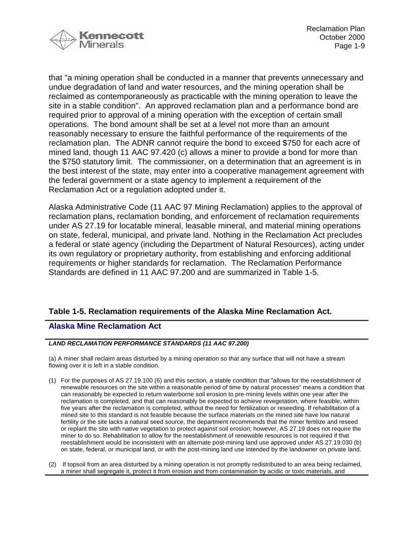
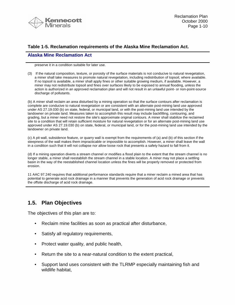
Table 1-5. Reclamation requirements of the Alaska Mine Reclamation Act.
Alaska Mine Reclamation Act
LAND RECLAMATION PERFORMANCE STANDARDS (11 AAC 97.200)
(a) A miner shall reclaim areas disturbed by a mining operation so that any surface that will not have a streamflowing over it is left in a stable condition.
(1) For the purposes of AS 27.19.100 (6) and this section, a stable condition that "allows for the reestablishment ofrenewable resources on the site within a reasonable period of time by natural processes" means a condition thatcan reasonably be expected to return waterborne soil erosion to pre-mining levels within one year after thereclamation is completed, and that can reasonably be expected to achieve revegetation, where feasible, withinfive years after the reclamation is completed, without the need for fertilization or reseeding. If rehabilitation of amined site to this standard is not feasible because the surface materials on the mined site have low naturalfertility or the site lacks a natural seed source, the department recommends that the miner fertilize and reseedor replant the site with native vegetation to protect against soil erosion; however, AS 27.19 does not require theminer to do so. Rehabilitation to allow for the reestablishment of renewable resources is not required if thatreestablishment would be inconsistent with an alternate post-mining land use approved under AS 27.19.030 (b)on state, federal, or municipal land, or with the post-mining land use intended by the landowner on private land.
(2) If topsoil from an area disturbed by a mining operation is not promptly redistributed to an area being reclaimed,a miner shall segregate it, protect it from erosion and from contamination by acidic or toxic materials, and
Reclamation PlanOctober 2000
Page 1-10
Table 1-5. Reclamation requirements of the Alaska Mine Reclamation Act.
Alaska Mine Reclamation Act
preserve it in a condition suitable for later use.
(3) If the natural composition, texture, or porosity of the surface materials is not conducive to natural revegetation,a miner shall take measures to promote natural revegetation, including redistribution of topsoil, where available.If no topsoil is available, a miner shall apply fines or other suitable growing medium, if available. However, aminer may not redistribute topsoil and fines over surfaces likely to be exposed to annual flooding, unless theaction is authorized in an approved reclamation plan and will not result in an unlawful point- or non-point-sourcedischarge of pollutants.
(b) A miner shall reclaim an area disturbed by a mining operation so that the surface contours after reclamation iscomplete are conducive to natural revegetation or are consistent with an alternate post-mining land use approvedunder AS 27.19.030 (b) on state, federal, or municipal land, or with the post-mining land use intended by thelandowner on private land. Measures taken to accomplish this result may include backfilling, contouring, andgrading, but a miner need not restore the site's approximate original contours. A miner shall stabilize the reclaimedsite to a condition that will retain sufficient moisture for natural revegetation or for an alternate post-mining land useapproved under AS 27.19.030 (b) on state, federal, or municipal land, or for the post-mining land use intended by thelandowner on private land.
(c) A pit wall, subsidence feature, or quarry wall is exempt from the requirements of (a) and (b) of this section if thesteepness of the wall makes them impracticable or impossible to accomplish. However, a miner shall leave the wallin a condition such that it will not collapse nor allow loose rock that presents a safety hazard to fall from it.
(d) If a mining operation diverts a stream channel or modifies a flood plain to the extent that the stream channel is nolonger stable, a miner shall reestablish the stream channel in a stable location. A miner may not place a settlingbasin in the way of the reestablished channel location unless the fines will be properly removed or protected fromerosion.
11 AAC 97.240 requires that additional performance standards require that a miner reclaim a mined area that haspotential to generate acid rock drainage in a manner that prevents the generation of acid rock drainage or preventsthe offsite discharge of acid rock drainage.
1.5. Plan Objectives
The objectives of this plan are to:
• Reclaim mine facilities as soon as practical after disturbance,
• Satisfy all regulatory requirements,
• Protect water quality, and public health,
• Return the site to a near-natural condition to the extent practical,
• Support land uses consistent with the TLRMP especially maintaining fish andwildlife habitat,
Reclamation PlanOctober 2000
Page 1-11
• Minimize or eliminate long-term management requirements,
• Ensure long-term stability, and
• Provide a basis for estimating the cost for reclaiming the mine.
A myriad of specific reclamation techniques may be used to accomplish the goalsoutlined above. Additionally, the technologies available for reclamation are constantlychanging as the industry gains collective experience with mine operation and closure.Consequently, the reclamation plan must provide a framework that encourageschanges in reclamation technologies, while providing clear guidance on theperformance requirements that the plan must achieve. Accordingly, the format of thisplan has been developed to define performance goals by describing specific post-closure monitoring requirements, including duration and frequency of inspection orsampling, compliance points, and compliance levels. Specific technologies that will beemployed to satisfy these performance goals are the responsibility of KGCMC. Adetailed reclamation plan will be submitted and periodically updated by KGCMC asrequired in Section 1.7.
1.6. Reclamation Schedule
The ultimate reclamation of a mine is often considered during the earliest stages ofmine design to ensure that facilities are sited, designed and operated in a manner thatis conducive to timely and cost-effective final reclamation. Reclamation activities mayoccur throughout the life of a mine operation. Five stages of reclamation have beendefined for the purposes of this plan as described below.
1.6.1. Interim ReclamationInterim reclamation includes all actions taken to stabilize disturbed areas duringoperation of the mine. Generally, the focus of interim reclamation is to reduce erosionand sedimentation of waterways, and to protect water quality.
Techniques used to protect slopes from erosion and to reduce sediment delivery intowater courses include various Best Management Practices (BMP’s) that are describedin more detail in the GPO Appendix 10. Management actions used to protect waterquality include surface water diversion, groundwater diversion, and collection andtreatment of contact water. These management actions are also described in moredetail in GPO Appendix 10.
KGCMC has striven to maintain habitat in its natural condition and improve the habitatin areas where it is feasible. Wildlife has quickly taken advantage of newly created
Reclamation PlanOctober 2000
Page 1-12
habitats at inactive production rock sites and along the roads that are maintained andimproved through interim stabilization seeding. The installation of a fish pass in GreensCreek is an example of an improvement in habitat. The fish pass was originallyproposed as mitigation for lost salmon rearing areas because the location and methodof surface tailings disposal would have interfered with these areas. Then KGCMCchanged how surface tailings disposal has been handled which minimized disturbanceto the salmon rearing areas. However, KGCMC still installed the previously proposedfish pass structures to allow salmon access to additional spawning habitat in middleGreens Creek.
KGCMC has routinely performed interim reclamation at inactive sites until finalreclamation can be completed, as required by the Forest Service leases and BMP’s.Interim reclamation has included hydroseeding and fertilization of disturbed sites tominimize erosion and reduce sediment production in these areas. Maintenance of theseareas has achieved the requirements of the leases and BMP’s and has resulted inhealthy grass and clover growth.
Berms, slope drains, straw bales, silt fences, catch basins, polymers, and hydroseedinghave been utilized for temporary erosion control since inception of the mine. Whenconstruction is in progress but cannot be completed until the following year, KGCMCremoves all temporary culverts and constructs temporary cross drains, drainageditches, dips, berms, culverts, or other facilities needed to control erosion.
KGCMC strives to implement soil stabilization and erosion control measures in alldisturbed and unprotected areas prior to the end of a normal operating season. Workon any additional disturbed areas commences when weather permits or when practical.
1.6.2. Concurrent ReclamationReclamation activities should be completed as soon as practical after portions of minefacilities achieve their final grade. Reclamation that is completed while the mine is stillin production is termed concurrent reclamation. Concurrent reclamation differs frominterim reclamation in that concurrent reclamation is designed to provide permanent,low maintenance achievement of reclamation goals.
Concurrent reclamation is encouraged for many reasons. First, it allows the mine andagencies to measure the performance of specific reclamation technologies before mineclosure and to refine the techniques for site-specific conditions. Next, concurrentreclamation reduces bonding requirements. Also, concurrent reclamation for areas ofthe mine project which are constructed in phases (e.g., tailings pile) can have beneficialeffects such as minimizing water infiltration. Additionally, concurrent reclamationfacilitates the determination of closure costs. Finally, evaluation of the performance of

Reclamation PlanOctober 2000
Page 1-13
concurrently reclaimed areas allows for a more accurate assessment of the likelihoodthat specific reclamation technologies will achieve performance goals.
Generally, for areas in which ARD risk may exist, KGCMC will initiate concurrentreclamation within 6 months of the time that both of the following conditions occur; 1)the performance of reclamation techniques such as the oxygen-excluding cover hasbeen verified by field evaluations and has been found to be effective, and 2) acontiguous area within a facility greater than 2 acres in extent has been brought to itsfinal grade. Five consecutive years of monitoring will be required to verify theeffectiveness of the cover. For other areas without a risk of ARD, concurrentreclamation shall be initiated within 6 months of the time that a contiguous area within afacility greater than 2 acres in extent has been brought to its final grade. Before areasmay be reclaimed concurrently with mine operation, a detailed reclamation plan mustbe submitted for Agency review and approval. Plan requirements are described inmore detail in Section 1.7.
1.6.3. Temporary CessationIn the event of temporary cessation of mining activities, KGCMC shall notify theappropriate Agencies in writing at least thirty days prior to any planned suspension orcessation of operations of ninety days or longer. KGCMC shall notify the Agencies ofany unanticipated suspension or cessation of operations expected to last more thanninety days or more within ten days of the first day of the temporary closure. The noticeshall state the nature and reason for the temporary closure, the anticipated duration ofthe temporary closure and any event that would reasonably be anticipated to result ineither the resumption or abandonment of operations. Project operations must resumefor not less than ninety consecutive days in order to terminate the temporary closurestatus. If a temporary closure extends beyond ten years, the Agencies may deemproject operations to be permanently abandoned or ceased, and whereupon finalreclamation must commence unless otherwise agreed to by the Agencies. KGCMCshall ensure that the project area is maintained in a safe and secure condition during atemporary closure and KGCMC shall not allow the project area to be degraded oreroded during or as a result of the temporary closure. KGCMC shall continue, in fullforce, all water collection and treatment, monitoring and reporting required by thereclamation plan unless otherwise agreed to by the agencies.
While the mine operation is inactive, environmental monitoring programs, including theinternal monitoring programs described in Appendices 3 and 11 will remain in effect.The need for implementation of interim reclamation activities or final reclamation oncomponents of the mine will be addressed on the basis of environmental monitoringresults and consultation with the appropriate agencies.
1.6.4. Final Reclamation

Reclamation PlanOctober 2000
Page 1-14
After KGCMC has completed operations at Greens Creek, or at any individual facility ormine unit, then final reclamation can be initiated. When a facility is no longer neededfor mine operation or when it has reached its design capacity, then reclamation shall beinitiated as soon as practical. It is assumed that at the final reclamation stage, asignificant amount of site-specific reclamation experience and performance data will beavailable. This information will be used to guide development of a site-wide closureplan. Before areas may undergo final reclamation, a detailed plan must be submittedfor Agency review and approval. Plan requirements are described in more detail inSection 1.7.
1.6.5. Post-Closure Care and MaintenanceAchievement of many reclamation goals can be expected over a number of years.During the period immediately after final reclamation, the site will be inspected,monitored and managed in a fashion that helps achieve the long-term goals set out inSection 2. Specific management actions that will be employed may depend in part, onthe results of post-closure monitoring. The sequence of response actions taken byKGCMC triggered by adverse monitoring results will be described in a detailedcontingency plan that will be submitted as part of the final reclamation plan for the mineor if temporary cessation lasts more than 3 years unless otherwise approved by theappropriate agencies.
1.7. Detailed Plan Submission and Approval
A detailed reclamation plan will be submitted periodically by KGCMC. The plan willcontain sufficient detail to allow calculation of closure cost including post-closuremaintenance and monitoring and to demonstrate that the reclaimed facilities willconform to performance standards, and will describe monitoring to be conducted duringthe post-closure period.
The first detailed reclamation plan shall be submitted on or before July 1, 2001, unlesslater submission is authorized in writing by the appropriate agencies. Subsequentupdates to the detailed reclamation plan will be submitted at least every five years. Thetiming of the five-year updates shall be coordinated with the five-year audits thatKGCMC and the agencies anticipate having conducted by a third-party auditor, so thatinformation developed during the audits can be taken into account in updating thedetailed reclamation plan. More frequent plan revision may be required by the agenciesif substantial increases in the disturbed area have occurred since the last reclamationplan revision, or if specific portions of the plan are shown to be incapable of meetingperformance goals.
The detailed reclamation plan shall contain preliminary engineering drawings andcalculations and a tabulation of material quantities required to complete thereclamation. Additionally, the plan will have a map of the mine area (with detailed maps

Reclamation PlanOctober 2000
Page 1-15
of Site 23/D, the mill area, the Tailings facility, and other facilities to be reclaimed withan engineered cover) showing final grades, location of channels and diversions, a siteaccess plan, and vegetation type/land use designations. The reclamation plan shouldalso contain a detailed schedule that designates all areas that have been (or will be)concurrently reclaimed by year.
Additionally, a detailed monitoring plan should be developed that identifies howmonitoring will be conducted for FWMP sites, internal contact water, and for vegetationestablishment. The monitoring plan should describe the sites monitored, the datacollected, and the monitoring frequency and duration.
Finally, the reclamation plan shall contain an evaluation of the predicted environmentalperformance of the facilities that demonstrates that performance goals will be met. Thedemonstration should consist of previously collected performance data from KGCMCfacilities (or from similar sites) that are used as inputs to appropriate models that predictsite-specific behavior.
1.8. Final Reclamation Plan and Monitoring/Contingency Plan
Prior to commencement of final reclamation of any facility at the site, KGCMC willsubmit a final reclamation plan that will be used as the basis for remaining reclamationactivities at the site. The final reclamation plan will follow the same format as priorupdates of the detailed reclamation plan. The final plan will also include a Monitoringand Contingency Plan that describes in detail what actions KGCMC would follow if thesite fails to meet performance goals during the post-closure monitoring period, includinglong-term contact water management, should that prove necessary. The actionsdescribed in the Contingency Plan may be used to determine potential costs that maybe associated with the post-closure care and maintenance period. These costs can beused to calculate the amount of bond that needs to be retained after incremental bondrelease (Section 1.9).
1.9. Bond Cost Calculation and Bond Release
Federal, State and municipal agencies have authority to require financial assurance forperformance of reclamation or facility closure and post-closure monitoring activities atGreens Creek. Agencies will coordinate their bonding authority through a memorandumof agreement or other mutually agreeable means. Proof of financial assurance, whichmay take any form mutually agreed upon by the agencies and KGCMC, is referred to asa “bond” in this section. Unless otherwise agreed between the agencies and KGCMC,the bond amount will be calculated on the basis of detailed reclamation plans submittedby KGCMC pursuant to this appendix.
1.9.1. Incremental Bond Release
Reclamation PlanOctober 2000
Page 1-16
A site or area will be eligible for release or partial release of the bond amount directlyattributable to that site or area when all pertinent aspects of final reclamation activitiesare complete, including: removing any facility and necessary materials, grading thesurface, applying cover-soils as necessary, and applying the final seed mix. Bondrelease can be sought for areas reclaimed concurrently (during operation) or after finalreclamation.
For a site or area subject to overlapping jurisdiction of the agencies, concurrence fromall agencies having jurisdiction over the site or area will be sought as to thecompleteness of the reclamation. KGCMC will apply for incremental bond release bysubmitting a letter to the appropriate agencies requesting release of the specific site orarea(s). Also, the letter will summarize the conducted reclamation activities, thereclamation activity schedule, and the final revegetation completion date.
The agencies will approve incremental bond release through a process upon which theyhave agreed. The agencies may require a joint agency/KGCMC site visit to confirm thatKGCMC has completed pertinent reclamation activities at the site or area(s). Thesereclamation requirements will be described in the detailed and final reclamation plans,in the waste disposal permit, and in other applicable permits. If required under thepost-reclamation/closure requirements of an applicable permit or approval, KGCMC willcontinue monitoring the site or area(s) in compliance with applicable permits orapproval until the agencies release the entire bond.
1.9.2. Bonding and Management During Post-Closure Care PeriodAfter mining activities are completed in a particular area, KGCMC will return the area toa natural appearing condition using the pertinent procedures described in thisReclamation Plan. After closure, a portion of the site’s total bond will be retained for aperiod to be determined in consultation with the agencies, in light of the applicable post-closure care requirements, to provide for personnel, materials, equipment, and repairsnecessary for monitoring, maintenance, and post-closure water management shouldreclamation maintenance and contingencies become necessary.
If monitoring shows that a site or area is not satisfactorily progressing toward meetingperformance goals, KGCMC, will within 60 days of problem identification propose forthe agencies’ concurrence a written corrective action plan which may require either orboth:
• Continued monitoring, with continued retention of the remaining bond amount,over an extended period until progress is made toward satisfaction of theperformance goals;
• Implemention of remedial measures to correct the situation delaying orpreventing attainment of those goals.

Reclamation PlanOctober 2000
Page 1-17
If remedial measures are implemented, KGCMC will, at the discretion of appropriateagencies, restart the monitoring period, which will delay final bond release. The agencyholding the bond, in accordance with the agreement among the agencies, may proceedwith final bond release if the problems being addressed through remedial measuresrepresent an insignificant proportion of the unreclaimed area compared to the overallsuccess of the reclamation closure.
1.9.3. Final Bond ReleaseFinal release of the remaining bond will occur when monitoring demonstrates thatperformance goals described in Section 2.0 have been met and any post-closuremonitoring required by an applicable permit or approval has been satisfactorilycompleted. Application for and final bond release will follow the same protocol asdescribed above for incremental bond release. Removal of monitoring equipment willfollow the joint agency/KGCMC site visit for confirmation of final bond release.
1.10. Reporting
Starting in 2001, KGCMC shall include in each annual report a tabulation of disturbedacreage and concurrently reclaimed areas (including date), and a description ofreclamation activities planned for the following year (provided in the report or in anattached annual workplan for the upcoming year). The report shall also contain anarrative and as-built drawings (in hard copy and in electronic form, if available) thatdescribe the reclamation. Annual reports are submitted to the Forest Service, ADECand ADNR. Additionally, performance monitoring of concurrently reclaimed areas, andpost-closure monitoring results will also be described in annual reports. Additionalreporting requirements are described in Section 2.0.
Reclamation PlanOctober 2000
Page 2-18
2. Performance Goals
2.1 Water Quality
2.1.1. Monitoring RequirementsThe KGCMC Fresh Water Monitoring Program (FWMP) in Appendix 1 of the GPOdocuments the necessary methods, procedures, analysis, data management, andinformation to fulfill the water quality monitoring requirements. After closure KGCMC willcontinue to:
• Sample and analyze groundwater monitoring wells per the latest FWMPschedule.
• Sample and analyze surface water monitoring sites per the latest FWMPschedule.
• Sample and analyze sediment and marine organisms, marine receiving watersand effluent bioassay as long as wastewater discharges continue under theNational Pollutant Discharge Elimination System (NPDES) permit.
If practical, remaining monitoring sites that were used in internal monitoring programs atProduction Rock Pile 23 and D, the Tailings facility, and at remaining inactiveProduction Rock piles will also continue to be monitored during the post-closuremonitoring period.
2.1.2. Waiver or ModificationWater quality monitoring shall be conducted for not less than 5 years after completionof reclamation activities and not less than 3 years after cessation of collection andtreatment of contact water (see Section 2.1.4). KGCMC may, however, requestmodification of the water quality monitoring requirements at any or all monitoring sites.Modifications may include removal of water quality monitoring stations, reduction inmonitoring frequency, or changes in constituents monitored. Request for changes inthe monitoring requirements at a facility will be contained in a report that demonstratesthat all downgradient monitoring stations have been in compliance with Alaska WaterQuality Standards (AWQS) for at least 3 consecutive years. Additionally, results ofmonitoring at internal sites must corroborate the finding that water quality downgradientof the facility will not change in the foreseeable future. The report will be submitted byKGCMC to the appropriate agencies for their review and approval prior to changingwater quality monitoring practices.

Reclamation PlanOctober 2000
Page 2-19
This waiver section should be interpreted jointly with waiver provisions contained in theFWMP. Where the waiver provisions contained in this document conflict with theFWMP, these provisions supercede the FWMP.
If a point source discharge permit remains in effect for the components of the mineaffected by the request for modification, then KGCMC will also obtain approval for anymodifications of the point source discharge permit from the agency or agencies havingpermit authority for the discharge.
2.1.3. Performance Standards and Point of ComplianceThe facilities will be in compliance if 1) all relevant AWQS are met at the downgradientmonitoring points specified in Table 2-1, or 2) if accepted detection monitoring statisticalanalysis, as set out in Section 10 of Appendix 1 (FWMP), applied to the upgradient anddowngradient stations fail to show a statistically significant increase in the constituents.These provisions supercede the compliance provisions of the FWMP.
Table 2-1. Proposed compliance monitoring locations for KGCMC facilities.
Facility Compliance Points
Mill Area/920 Portal/1350 Adit Upgradient - Site 48 (upper Greens Creek)
Downgradient - Site 6 (middle Greens Creek),
Production Rock Pile 23/D Upgradient - Site 6 (middle Greens Creek)
Downgradient - Site 54 (Greens Creek belowD Pond)
Tailings Upgradient - Site 58 monitor well MW-T001C(peat), and Site 59 monitor well MW-T001A(till)
Downgradient - Tributary creek headwaters /Site 27 monitor well MW-2/shallow (peat), andSite 28 monitor well MW-2/deep (till)
Downgradient - West side / Site 29 monitorwell MW-3/shallow (peat), and Site 30 monitorwell MW-3/deep (till)
All other areas No specific compliance point identified.

Reclamation PlanOctober 2000
Page 2-20
2.1.4. Contact Water ManagementDuring operation of the Greens Creek mine, seepage collected beneath Site 23 and theTailings facility, and waters that run off of Site 23, Site D, the mill area, and the Tailingsfacility are collected and treated. Collectively, these waters, known as “contact water”,are collected and treated prior to discharge under an NPDES permit. In order to returnthe site to a near-natural condition and minimize or eliminate long-term managementrequirements, KGCMC plans to phase out collection and conventional treatment ofcontact water. In order to ensure that water quality will be protected after KGCMCceases to collect and treat contact water, the following requirements shall be satisfied.
• Before KGCMC will be allowed to cease collection and conventional treatment ofcontact water, a report will be developed by KGCMC for submission to theappropriate agencies. The report will utilize a water quality predictive model ofthe Production Rock and Tailings facilities to determine whether AWQS will bemet at downgradient stations, and will include identification of effective treatmentmethods. Achievement of AWQS at the compliance point can be by any of thefollowing processes alone or in combination: reduction in ARD or metals loadsdue to reclamation practices, deployment of demonstrated biological or othernon-conventional treatment techniques, or reliance on natural attenuationmechanisms.
• A monitoring plan must be submitted with the report that identifies “earlywarning” stations that will detect increases in metal loading that represent aprecursor to violation of AWQS at the facility compliance point. The monitoringplan shall describe the indicator parameters to be monitored, the monitoringfrequency, and duration. Additionally, “trigger levels” shall be proposed at eachearly warning station that represents levels of constituents that may causesubsequent violation of AWQS at the compliance point.
• The findings of the report, and the monitoring plan are subject to review andapproval by the appropriate agencies.
Early warning stations and the downgradient point of compliance shall be monitored fora minimum of 3 years after cessation of collection and treatment of contact water. Ifviolation of the AWQS occurs at the compliance points, or if trigger levels are exceededat the early warning stations, then KGCMC shall notify the agencies as required by theFWMP. Additionally, a report shall be prepared which describes the potential orobserved water quality violation, and will identify probable causes. This report shall besubmitted by KGCMC to the appropriate agencies within 30 days of problemidentification. A corrective action plan shall be submitted by KGCMC to the appropriateagencies for review and approval within 75 days of the date of problem identification.Following approval of the plan, KGCMC shall implement the plan in a timely manner.The corrective actions to be taken may include, but need not be limited to, changes in
Reclamation PlanOctober 2000
Page 2-21
the passive treatment system, modification of the water management system, re-establishment of conventional treatment, or improvements to the facility reclamation.
2.2. Demolition
2.2.1. Solid WasteStructures that have been constructed on Forest Service administered lands will bedemolished. All material and equipment will be salvaged and recycled wheneconomically feasible. All hazardous materials will be removed as described in Section2.2.2 below. Materials that cannot be salvaged will be removed from the site fordisposal or disposed on-site in an appropriate manner. If applicable, a solid wastepermit will be obtained for on-site disposal of demolition debris.
KGCMC will recover and remove all salvageable equipment, instrumentation, furniture,unused chemicals and fuels, and other salvageable or waste material followingpermanent closure of the operation. All mobile equipment and other equipment notneeded for future potential uses of the site will be salvaged and removed from the site.Removal will consist of loading at the site, transporting to the KGCMC Hawk Inlet facilityand offloading to a barge. These materials will either be shipped to buyers, recyclers, orto an approved waste disposal area.
2.2.2. Hazardous MaterialsHazardous materials that remain on-site at the time of final reclamation, whether in theform of unused process reagents, fuels or lubricants, or as residue from demolition ofthe site (contaminated soil, etc.) shall be removed from Admiralty Island and will beproperly recycled or disposed under applicable State and Federal law.
2.3. Land Use/Vegetation
2.3.1. Roads and Site AccessAs a part of periodic updates of the detailed reclamation plan and the final reclamationplan that will be submitted by KGCMC to the appropriate agencies, a site access planwill show the roads and trails that are retained after facility closure. Additionally, anapproximate time frame for road removal will be developed. Road access will beretained to the Tailings facility, production rock piles, mill area and portal for at least thefirst five years after closure. Roads will be maintained for longer if necessitatedbecause of continued collection and treatment of contact water (Section 2.1.4). The siteaccess plan shall be developed in a manner that balances the need for economic post-closure care and maintenance and for achieving the goal of returning the site to a near-natural condition.
Reclamation PlanOctober 2000
Page 2-22
2.3.2. AestheticsThe final reclamation plan shall be reviewed by a qualified professional to assess thedegree to which the reclamation plan meets the aesthetic goals of the plan. Examplesof aesthetic considerations in a reclamation plan may include but are not limited to:
• reduction in the extent of long uninterrupted slope crests with the sameelevation,
• design of contours on reclaimed facilities that have crenulations in plan view (e.g.having an irregularly wavy or serrate outline) that approximate those found insurrounding landforms,
• creation of slopes that have a similar profile to those found in surroundinglandforms (e.g. concave or convex profiles), and
• integration of natural drainage networks into reclaimed slopes.
Aesthetic considerations may conflict with other performance goals such as stability orenvironmental performance of engineered covers. Where such conflicts exist,environmental protection shall take precedence over aesthetics.
2.3.3. RevegetationDisturbed areas at Greens Creek will be reclaimed to one of three vegetation typesincluding upland meadows, upland forest, or wetlands. Specific seed mixtures, woodyseedling density, and maps showing each vegetation type will be submitted within thedetailed reclamation plan.
Revegetation success will be monitored for three years following seedbed preparation,fertilization, seeding, mulching, and temporary erosion control measures. Fallrevegetation surveys will be conducted the first year and a fall survey will be conductedthe second and third year. Growth, ground cover, and species survival will be measuredand reported on an annual basis. Specific goals for different plant communities arespecified in Section 2.3.3.4.
2.3.3.1. Upland Meadow AreasIn all reclaimed areas with slope greater than 25%, the soils will first be stabilized usinga hydromulch mixture. A seed mixture containing predominantly native species, to beapproved by the Forest Service prior to use, will be broadcast at a rate of 30 lbs purelive seed per acre or other approved rate. Additional native species may be added tothe mix to provide cover and variety based upon seed availability and their suitability forhydroseeding. These species may consist of forbs, grass species, blueberries and otherfood sources that would benefit the wildlife.

Reclamation PlanOctober 2000
Page 2-23
Areas reclaimed with grass and forbs on Admiralty Island have shown significant use bya wide range of wildlife species; deer, bear, rodents, raptors, and songbirds. KGCMCwill generally limit open meadow areas to 10 contiguous acres to enhance edge-effect,benefit wildlife, improve aesthetics, and advance the rate of succession to the nextseral stage.
2.3.3.2. Upland Forest AreasForest stands will be developed using a combination of natural regeneration andreseeding or transplanting. Natural regeneration is preferred over planting as a meansof establishing a coniferous overstory in small areas where seed sources are available.Natural regeneration will ensure re-establishment of Admiralty Island genotype species,follow natural successional stages, and provide unique wildlife habitat during standdevelopment. Naturally-regenerated plants are well adapted to growing on site. Theseeds either migrate from surrounding native plants or, in many instances, are alreadyin the soil. Natural regeneration benefits the environment by ensuring the succession ofnaturally occurring, site adapted genotype species.
According to an Alaska Forest Management Education Alliance (AFMEA) pamphlet onForest Regeneration, Alaska has some unique regeneration opportunities that relate tothe type of trees and cold soils in Southeast Alaska. The coastal forests of SoutheastAlaska regenerate very quickly and profusely. Approximately 95% of disturbed areasseed-in naturally from surrounding stands. Western hemlock and Sitka spruce growrapidly in this area. Natural regeneration of these climax species is evident throughoutareas previously disturbed by KGCMC activities and in areas without any reclamationpreparation.
KGCMC will utilize natural regeneration as the primary method of woody plantrestoration in areas seeded as upland meadows and in disturbed areas less than 200feet in their shortest dimension. Accelerated regeneration through seeding will beimplemented in more expansive reclaimed areas. Accelerated regeneration wouldconsist of planting more of the climax species to minimize large open areas andaccelerate succession.
In areas where the trees propagate either from natural regeneration or from plantedseedlings, KGCMC may thin the subsequent growth to allow the remaining trees togrow more quickly and achieve climax forest conditions.
2.3.3.3. Wetland AreasWetlands provide food, protection from predators, and other vital habitat factors formany fish and wildlife species. Wetland systems have economic value associated withrecreational, commercial, and subsistence use of fish and wildlife resources. Inaddition, wetlands remove sediment from overland flows before they reach lakes, riversand bays. Wetlands intercept storm runoff and release floodwaters gradually to

Reclamation PlanOctober 2000
Page 2-24
downstream surface and groundwater systems. A significant portion of the GreensCreek temperate rain forest setting supports wetlands. Riparian, muskeg, and forestedwetland communities all occur in the area.
Final reclamation will provide additional wetland habitats. KGCMC has an agreementwith the U.S. Army Corps of Engineers to compensate for wetlands lost duringconstruction by re-establishing and creating additional wetlands. These wetlands willmitigate disturbances and protect the biological productivity for a unique wildlife habitat.KGCMC currently intends to create several wetland sites if the opportunity andconditions are ideal for wetlands. Others will be constructed to maintain adequatehydrology in existing, adjacent, and restored wetlands.
Constructed wetlands will be monitored annually for three years. Permanent vegetationsampling points will monitor plant establishment, growth, and relative abundance.
2.3.3.4. Specific Plant Community GoalsVegetation on reclaimed areas at Greens Creek shall be subject to the monitoringrequirements and performance standards described below. Roads used for permanentaccess and other areas where buildings are maintained for post-mining use, shall notbe subject to vegetation standards.
Vegetation success will be monitored through annual inspections, as well as by surveysof the reclaimed areas in years 1, 2 and 3 following completion of reclamation activities.KGCMC shall submit reports to the Forest Service, ADEC, ADNR and the U.S. ArmyCorps of Engineers describing the results of these revegetation surveys by the firstquarter of the calendar year following completion of annual data collection andmonitoring activities. The reports shall include an assessment of vegetation success.Climatic variation and its effects on vegetative growth rates will be considered in thisassessment.
Vegetation establishment and success on each reclaimed facility shall be monitoredthrough the establishment of transect lines. Transect locations for all reclaimed areasshall be selected by KGCMC in consultation with the appropriate agencies. Vegetationinspections of all reclaimed areas shall follow the following guidelines:
• Visual inspections of vegetation cover by life-form will be conducted (includingannual grass, perennial grass, forbs, shrubs, trees, litter and standing dead.)Evidence of dieback, subsidence, slope failures or erosion will be noted.
• Inspections will be conducted on permanent transects.
• Pedestrian traffic will be restricted to the downhill side of the transect line andpeople will not be allowed to walk on the plots.
Reclamation PlanOctober 2000
Page 2-25
• Vegetation monitoring will be conducted once each year during peak standingbiomass.
Revegetation efforts shall be considered successful when the following conditions aremet:
• The total vegetative cover (including live biomass of perennial species, litter, andstanding dead) in each revegetated area is equal to or exceeds 80 percent aerialcover, with a 90 percent statistical confidence limit;
• The density of actively growing trees is within 80 percent of target levelscontained in the approved reclamation plan with a 90 percent statisticalconfidence;
• The reclaimed wetland and plant meadow areas have at least three graminoidspresent each with relative herbaceous cover value equal to or greater than 5percent, with no one graminoid comprising more than 70 percent relative cover;
• The reclaimed upland forest areas have at least two species of trees and onespecies of shrubs present, with each species comprising no less than 5 percentor no greater than 95 percent of the relative density value.
If vegetation monitoring indicates that, due to natural or other causes, a reclaimed areadoes not exhibit the potential to achieve the revegetation standards described above, areport shall be prepared which describes the area in question, the situation asidentified, probable causes, and a corrective action plan. This report shall be submittedby KGCMC to the appropriate agencies within 60 days of problem identification.Following approval of the plan by the appropriate agencies, KGCMC shall implementthe plan in a timely manner. The corrective actions to be taken may include, but neednot be limited to, re-establishment of topsoil thickness, reseeding, and replanting oftrees and shrubs.
2.3.4. Wildlife UseKGCMC will conduct qualitative wildlife species counts to monitor wildlife habitatutilization and wildlife habitat potential of the reclaimed areas. These counts will beconducted and reported on an annual basis.
Reclamation PlanOctober 2000
Page 2-26
2.4. Stability
2.4.1. Mass InstabilitySemi-annual inspections of all reclaimed areas for evidence of slope instability shall bemade in year 1. Annual inspections will be made in years 2, 3 and 5 followingcompletion of reclamation activities. Additionally, Site 23/D, the Tailings Facility, andother facilities reclaimed with engineered covers will be monitored every five years forthe duration of the post-closure mandatory period specified in the waste disposalpermit. KGCMC shall submit a slope-stability report to the appropriate agencies,summarizing the findings of the periodic inspections.
• Development Rock Piles: The slopes and benches of the waste rock pile shallremain in a stable condition.
• Underground Mine: The portal area and stopes within 50 feet of land surfaceshall be monitored for signs of geotechnical instability.
• Tailings Pile: The slopes and benches of the tailings pile shall remain in a stablecondition.
• Other Reclaimed Areas: The slopes of other areas throughout the permit area,including the mill area, borrow areas, reclaimed exploration roads, access roads,and other support facilities shall remain in a stable condition.
Mass instability, including slope failure and subsidence in the above areas, shall besubject to the contingency requirements described below.
Production Rock Pile: If slope movement, subsidence, erosion or other massinstability which threatens the performance of the reclaimed soil cover occurs, KGCMCshall notify the appropriate agencies within two business days of problem discovery,and shall take timely action to prevent excessive entry of surface water into the pile.Additionally, a geotechnical investigation shall be conducted, and a report describingthe cause of the failure and appropriate remedies for completing necessary repairs andfor preventing future slope movement shall be submitted by KGCMC to the appropriateagencies for review. After review and approval of the plan by the appropriate agencies,KGCMC shall implement the corrective measures described in the plan in a timelymanner.
Underground Mine: If crown pillar failure occurs over any stopes, or if developmentheadings collapse near the portal, KGCMC shall notify the appropriate agencies withintwo business days of problem discovery, shall conduct a geotechnical investigation todetermine the cause of such failure and shall propose a corrective action plan forreview. After review and approval of the plan by the appropriate agencies, KGCMCshall implement the approved plan in a timely manner.
Reclamation PlanOctober 2000
Page 2-27
Tailings Pile: If slope movement, subsidence, erosion or other mass instability isobserved in the tailings pile, KGCMC shall notify the appropriate agencies within twobusiness days of problem discovery. A geotechnical investigation shall be conducted toascertain the extent of the problem, and a report describing the situation as identified,including estimates of the volume affected by the instability and potential consequencesof the instability with respect to its affect on the integrity of the cover system anddrainage features, shall be developed by KGCMC and submitted to the appropriateagencies within 30 days of the date of problem identification. A corrective action planshall be submitted by KGCMC to the agencies for review and approval within 75 days ofthe date of problem identification. Any remedial measures undertaken in conjunctionwith the corrective action plan shall be completed in a timely manner, which minimizesdisturbance to reclaimed areas and meets all original design criteria for the tailings pile.
Other Reclaimed Areas: If slope movement, subsidence or other failure whichthreatens the integrity of any other reclaimed area occurs, KGCMC shall notify theappropriate agencies within 30 days of problem discovery and shall repair any damagethat could affect other reclaimed facilities in a timely manner.
2.4.2. Permanent Channels and Channel InspectionSurface water flows will be managed in most cases by establishing vegetative cover andconstructing moderate slopes. Most slopes will be constructed with a 3H:1V slope.Constructing slopes at 3:1 reduces the erosive effects of water. In areas with minor flowconcentrations, straw bales, silt fences, and swales will be used to reduce the velocity ofthe water and reduce erosion while vegetation becomes established. Also, hydroseedingof these areas will stabilize the soils.
If natural stream channels enter reclaimed areas the water will be diverted, diffused, orchanneled through the reclaimed area using designed and constructed non-erosivechannels. Stream channels will be stabilized with degradable fiber mat to establishvegetation. Riprap will be used to stabilize the constructed channels in areas that aresubject to highly erosive stream flows.
All drainage channels and diversion structures installed during reclamation of the GreensCreek Mine shall be designed to handle flows from a 24 hour/25 year storm event, at aminimum, and shall be subject to the routine inspection and maintenance requirementsdescribed below.
In order to ensure that the drainage channels and diversion structures are functioningproperly, they shall be inspected semi-annually for signs of excessive erosion for fiveyears following completion of reclamation activities. After the first two years ofmonitoring, KGCMC may propose to the appropriate agencies that inspection beconducted less frequently if appropriate. During the five year period, drainage channelsand diversion structures shall be inspected within 24 hours following storm events in
Reclamation PlanOctober 2000
Page 2-28
excess of 2 inches of rainfall for signs of deterioration and erosional damage as well assedimentation.
During the remainder of the post-closure monitoring period required under the wastedisposal permit, drainage channels and diversion structures shall be inspected after eachstorm event that exceeds the largest prior storm that has occurred since completion ofreclamation. The appropriate agencies may require more frequent inspection by KGCMCduring the post-closure monitoring period if the drainage channels and diversionstructures are shown to require frequent maintenance or repair.
Routine inspections and inspections completed after major storm events shall be subjectto the following requirements:
• Physical damage, trash build-up and sedimentation shall be recorded on fieldinspection sheets.
• Diversion intake and outflow areas shall be inspected for evidence of scouring orbypass.
• Any areas needing maintenance or repair shall be reported on the field inspectionsheets.
If damage is noted, appropriate repairs shall be completed by KGCMC in a timelymanner. A summary of all observed damage requiring repair shall be submitted annuallyto the appropriate agency, including as-built reports verifying the completion of therequired repair.
If significant damage or overflow is caused by storms that are smaller than the structure’sdesign storm, KGCMC shall conduct an investigation to identify the cause of significantdamage or overflow of diversions. A report shall be prepared by KGCMC identifying theextent of the problem and the probable causes. The report shall be submitted to theappropriate agencies within 30 days of the date of problem identification. A correctiveaction plan shall also be submitted to the appropriate agencies for review and approvalwithin 75 days of the date of problem identification. The corrective actions to be takenmay include, but need not be limited to, regrading, armoring of drainage features, re-design and re-construction of channel cross-section and alignment, replacement oftopsoil, reseeding, and replanting of trees and shrubs. After approval by the appropriateagencies, KGCMC shall implement the plan in a timely manner.
2.4.3. DrainageThe surface of the reclaimed facilities shall be maintained in a free-draining condition,which allows water to egress the facility without ponding or causing erosion, to theextent practical.
Reclamation PlanOctober 2000
Page 2-29
If significant ponding of water occurs on the surface of any non-wetland reclaimedfacility, KGCMC shall notify agencies within two business days of the date of problemidentification. In addition, the extent of such ponding will be ascertained and a reportdescribing the situation as identified, including probable causes, shall be developed byKGCMC and submitted to the agencies within 30 days of the date of problemidentification. A corrective action plan shall be submitted by KGCMC to the agenciesfor review and approval within 75 days of the date of problem identification. Followingapproval of the corrective action plan by the agencies, KGCMC shall implement theplan in a timely manner. The corrective actions to be taken may include, but need notbe limited to, the following steps:
• placement of additional fill that meets original design criteria.
• regrading of placed fill to original design criteria.
• placement of growth medium to original design thickness.
• reseeding/planting as per original design specifications.
Any such remedial measures shall be undertaken in a manner that minimizesdisturbance to adjacent reclaimed areas.
2.4.4. Cover Performance and Inspection
2.4.4.1. Cover PerformanceField instrumentation will be installed to monitor performance of engineered coversused at KGCMC. The installation includes the following components:
• A weather station for measuring precipitation, net radiation, relative humidity,temperature, and wind speed.
• Thermal conductivity sensors to measure soil suction and temperature.
• Lysimeters to measure infiltration rates.
• Neutron Probe access tubes for monitoring water content profiles at selectedlocations on the site.
Construction details for the installation of the instrumentation is shown in the USELWaste Rock Cover Design Final Report (1998). KGCMC proposes to monitor coverperformance for 5 years beginning with installation of the Site 23 cover. KGCMC willdetermine from these monitoring results whether to propose additional coverperformance test monitoring in which instrumentation will be installed at other selected
Reclamation PlanOctober 2000
Page 2-30
cover sites. The monitoring approach is subject to review and approval by theappropriate agencies.
2.4.4.2. Cover InspectionIn order to ensure that the cover systems are functioning properly, they will beinspected semi-annually for five years following completion of reclamation activities forsigns of excessive erosion, damage due to blow-down of trees or damage by animals.Excessive erosion is defined to be erosion that has exposed or threatens to expose anylow permeability layer or oxygen excluding layer due to removal of soil. After the firsttwo years of inspection, KGCMC may propose to the appropriate agencies thatinspection be conducted less frequently, if appropriate. During the five year period, thecover system, diversion structures and drainage channels shall also be inspected byKGCMC within 24 hours following storm events in excess of 2 inches of rainfall for signsof deterioration and erosional damage as well as sedimentation. Any necessary repairsshall be completed by KGCMC in a timely manner.
If levels of erosion which are potentially destructive to the low permeability or oxygenexcluding layer are identified, KGCMC shall notify the appropriate agencies within twobusiness days of the date of problem identification. In addition, the extent of theproblem will be ascertained and a report describing the situation as identified, includingprobable causes, shall be developed by KGCMC and submitted to the agencies within30 days. A corrective action plan shall be submitted to the agencies for review andapproval within 75 days of the date of problem identification. Following approval of thecorrective action plan, KGCMC shall implement the corrective action plan in a timelymanner. This work may include, but need not be limited to, regrading, armoring ofdrainage features, re-establishment of topsoil thickness, reseeding, and replanting oftrees and shrubs.
If the cover system is breached by rodents and/or other digging wildlife, the extent ofthe problem will be ascertained and a report describing the situation as identified,including probable causes shall be developed by KGCMC and submitted to theappropriate agencies within 30 days of the date of problem identification. A correctiveaction plan shall be submitted to the agencies for review and approval within 75 days ofthe date of problem identification. Following approval of the corrective action plan,KGCMC shall implement the plan in a timely manner. If removal and/or relocation ofanimals is required, State of Alaska and Forest Service biologists shall be consultedregarding the removal/relocation process. In the event of an emergency need toremove or relocate animals when no biologist is available for consultation, KGCMCshall consult with qualified wildlife biologists and submit a summary report of the actionstaken to the agencies.
Repair of the low permeability layer shall include, but need not be limited to, thefollowing steps:
Reclamation PlanOctober 2000
Page 2-31
• removal of growth medium from the affected and immediately adjacent area andstockpiling.
• removal of the damaged areas of the low permeability layer or oxygen-excludinglayer.
• re-installation of the cover components in affected areas to the designperformance criteria under the same QA/QC procedures as the originalinstallation. The edges of the re-installed layers will overlap with the adjacentundisturbed layers to assure adequate joining of the layers.
• replacement of overlying cover layers to their original design thickness.
• reseeding/planting as per original design specifications.
All such repairs shall be undertaken in a manner that minimizes the disturbance to thesurrounding reclaimed area. KGCMC shall submit an as-built report of the workperformed under the corrective action plan to the agencies.
2.4.5. ErosionAll reclaimed areas shall be inspected semi-annually for five years following completionof reclamation activities for signs of excessive erosion. After the first two years ofmonitoring, KGCMC may propose to the appropriate agencies that inspection beconducted less frequently if appropriate. Routine monitoring shall include a visualassessment of rills and gullies.
Erosion of applied cover-soil from the production rock piles or tailings pile shall notexpose significant contiguous areas of low permeability or oxygen excluding layers orotherwise be allowed to significantly decrease the performance of the reclaimed soilcover in minimizing infiltration into the pile.
Erosion of applied cover-soil from reclaimed roads, borrow areas, the mill area, andother reclaimed areas shall not be permitted to significantly decrease the performanceof the reclaimed soil cover in supporting vegetation.
If erosion features deeper than 8 inches develop, KGCMC shall repair the damagedareas in a timely manner. If large numbers of significant erosion features are evidentduring an inspection period (more than 25 rills per acre over an area of 1 acre or more),then a mitigation plan to prevent recurrence of the erosion shall be developed,submitted for agency review and approval, and implemented by KGCMC. Elements ofsuch a mitigation plan may include, but need not be limited to, regrading or otherwisere-directing surface runoff away from the affected areas.

Reclamation PlanOctober 2000
Page 2-32
If potentially destructive levels of erosion are identified, KGCMC shall notify theappropriate agencies within two business days. In addition, KGCMC shall determinethe extent of erosion and shall submit a report describing the situation identified andprobable causes to the appropriate agencies within 30 days of the date of problemidentification. A corrective action plan shall be submitted by KGCMC to the appropriateagencies for review and approval within 75 days of the date of problem identification.Following approval of the corrective action plan, KGCMC shall implement the plan in atimely manner. This work may include, but need not be limited to, regrading, armoringof drainage features, re-establishment of topsoil thickness, reseeding, and replanting oftrees and shrubs.

Reclamation PlanOctober 2000
Page 3-1
3. Attachment A: Reclamation Plan1
• This section to be developed and submitted by KGCMC by 7/1/20012