Embed Size (px)
Citation preview

UNEP’s Global Environmental Alert Service (GEAS)
Table of Contents
Part 1: GEAS concept paper
Part 2:GEAS implementation plan

Part 1
Global Environmental Alert Service (GEAS)
Vision: Everyone in the world should have access to information about what is happening to his or her environment.
Mission: Providing scientific information for decision making.
Goal: Empowering people with engaging environmental information.
Executive Summary
Empowering people with engaging environmental information in a near-real time mode is now in the realm of reality. Decades after its birth, the Internet is slowly blossoming into a uniquely social medium that makes new information easily and continually available by harnessing the power of modern information and communication tools. UNEP's Global Environmental Alert Service (GEAS) will use the Internet to provide people with online access to compelling and dynamic information about environmental changes as they occur. This vehicle will be an engaging platform that piques interest in environmental issues and a tool that can help to mitigate environmental harm. The GEAS platform could well become the standard delivery mode for up-to-date information about any and all environment-related topics and the locales affected. One can easily imagine the BBC, CNN, and Google using the GEAS ‘UNEP Living Sources’ for describing the world’s environmental affairs. Harnessing the power of the Internet, GEAS will build on UNEP’s existing infrastructure to enhance and accelerate the flow of information from scientific research and earth observation systems to environmental decision makers and the general public. Although much information and many data sets are currently available in the public domain, there is a need for a credible information broker that searches and packages the policy-relevant material and delivers that information in an easily understood format to the public and decision makers.
The Global Environmental Alert Service has three components that would support short- and long-term decision-making:
Component 1: Near Real-time Environmental Hazards AlertsGEAS will be a notification service that uses appropriate formats (email, web service with real-time maps) to alert people to what is happening to their environments so that timely decisions can be made
Component 2: Environmental Hotspots AlertsThrough change studies of photographs, satellite images, maps and narratives, GEAS will document visual evidence of global environmental

change resulting from natural processes, human activities and the interaction between them
Component 3: Environmental Science AlertsAs a support for environmental decision making, GEAS will provide decision makers and all interested users with policy-relevant scientific findings about the environment condensed into short reports or briefing notes
The long term vision is that UNEP becomes a household word as the provider of environmental solutions to periodic routine societal queries. A related notion is that the public should be able to click on an area of interest and find out what is happening to their changing environment. This also leads to growth of Environmental Science on the Internet.
It is feasible that over time, people begin to change their everyday habits – from the coffee they drink in the morning to the way they get to work – to more environmentally benign action because information gleaned from GEAS has clearly shown the implications their personal choices have on the planet.
UNEP’s Global Environmental Alert Service (GEAS)WHY?
Vision: Everyone in the world should have access to information about what is happening to his/her environment
Mission: Providing scientific information for decision making
Goal: Empowering people with engaging environmental information
WHAT?
Grand integrator and communicator of scientifically credible data andinformation;
Proactive in delivery of information to users via email, webservices and other media;
Leverage upon partners assets and provide outlet to their products and services;
Harness the power of Internet and other ICT tools e.g. 3 D visualization, mapping etc.
WHY?
Potential of making UNEP a credible authoritative sources ofenvironmental information;
Connecting stakeholders and catalyzing actions;
HOW?
Business model between Nupedia (failed because of heavy peer review process) and Wikipedia (growing lack of credibility)
GEAS component 1: Near-Real

Connecting producer of information to consumers;
UNEP as a source of information to CNN, BBC etc.;
Implementation of the Bali Plan: Catalyze national actions forcollection of data and provide public access to environmental information;
Value added over Global Earth Observation System of Systems (GEOSS) products and services;
Accountability and transparency – Visualization tools.
Time Environmental Hazards Alerts
GEAS component 2: Environmental Hotspots Alerts
GEAS component 3: Environmental Science Alerts
UNEP’s Mandate: the Present Scope
Among UNEP’s principal mandates is the following:
“To keep under review the world environmental situation in order to ensure that emerging environmental problems of wide international significance receive appropriate and adequate consideration by governments.” (UN General Assembly 1972)
UNEP is the designated authority of the United Nations system regarding environmental issues at global and regional levels. Its mandate is to coordinate the development of consensus on environmental policies and action by keeping the global environment under review and bringing emerging issues to the attention of governments and the international community. Through its periodically released publications, UNEP is the voice for the environment within the United Nations system, providing access to environmental data and information as well as informing the international community of policy options to address environmental issues.
To fulfill this mandate, UNEP produces a suite of Global Environment Outlook (GEO) products, including its flagship report released every five years. Released between these major reports, the GEO Year Book consists of an annual survey of the changing global environment. In addition to the GEO products, a number of thematic reports are produced. These and other published materials attempt to provide an analysis of the state of the environment at global and regional levels.
Furthermore, the Bali Strategic Plan for Technology Support and Capacity-building stipulates the following cross cutting activities to fulfill the UNEP mandate:

1. Development of national research, monitoring and assessment capacity, including training in assessment and early warning;
2. Support to national and regional institutions in data collection, analysis and monitoring of environmental trends;
3. Access to scientific and technological information, including information on state-of-the-art technologies;
4. Education and awareness-raising, including networking among universities with programmes of excellence in the field of the environment.
The mandate of UNEP’s Division of Early Warning and Assessment (DEWA) is to provide the world community with improved access to meaningful environmental data and information, and to help increase the capacity of governments to use environmental information for decision making and action planning for sustainable human development. Thanks to the wide and rapid spread of the Internet, which has dramatically expanded the geographic boundaries of our communication abilities, UNEP will be able to broaden its ability to collect and disseminate environmental information and assist in technology support and capacity building.
A new opportunity for timely environmental alerts
An extreme decentralization of information and data through the World Wide Web makes it possible for millions of people worldwide to have easy, instantaneous access to a vast amount of diverse online information. This powerful communication medium has spread rapidly to interconnect our world, enabling near-real-time communications and data exchanges worldwide. According to the Internet World Stats database, as of 31 December 2006, global documented internet usage was 1,300 million people (http://www.internetworldstats.com/stats.htm). Thus, the Internet has become an important medium to access and deliver information worldwide in a very timely fashion.
In addition, remote sensing satellites now provide a continuous stream of data. They are capable of rapid and effective detection of environmental hazards such as transboundary air pollutants, wild fires, deforestation, changes in water levels, and natural hazards. With rapid advances in data collection, analysis, visualization and dissemination, including technologies such as remote sensing, Geographical Information Systems (GIS), web mapping, sensor webs, telecommunications and ever growing Internet connectivity, it is now feasible to deliver relevant environmental information on a regular basis to a worldwide audience relatively inexpensively. In recent years, commercial companies such as Google, Yahoo and Microsoft, have started incorporating maps and satellite imagery in their products and services, delivering compelling visualization and providing easy tools that everyone can use to add to their geographic knowledge.
Information is now available in a near-real-time mode from a variety of sources at global and local levels. In coming years, the multi-scaled global information network will greatly improve thanks to new technological advances facilitating the distribution of global environmental data and information at all levels. Globalization and timeliness of communication provides an unprecedented opportunity for UNEP’s GEAS to catalyze

environmental action at every level by rapidly providing its stakeholders with high-quality, scientifically credible information.
To accomplish this, however, UNEP needs a formal network to efficiently collect, synthesize and integrate information derived from earth observation systems and scientific research and to distribute that information in a timely manner throughout the United Nations decision-making structure and to policy makers and the wider public at global, regional and local scales.
The Global Environmental Alert Service (GEAS)
The Global Environmental Alert Service (GEAS) will complement UNEP’s current efforts in assessing global, regional and national environmental conditions and disseminating findings to nations and the public in a more timely fashion, enhancing cooperation and capacity building efforts.
GEAS builds upon the following emerging trends related to environmental information:
New approach Traditional approach
Continuous monitoring and prediction of changes
One-time assessments
Solution-oriented studies Problem raising studies
Rise of civil society and growth of issue-based communities to precipitate change
Information delivered to governments only
Data integration from several sources Sole production of data
Studies involving affected population Wild area studies
Multiple-risk information Single-risk information
Rapid response to real-time events Post-event responses
Internet tools for mass communication with compelling, dynamic, 3D visualization
Paper copy reports distributed to specific audiences
Using a multi-scaled approach, GEAS will build on UNEP’s existing infrastructure to enhance and accelerate the flow of information from scientific research and earth observation systems to environmental decision makers and the general public. GEAS will directly contribute to UNEP’s efforts at providing evidence of environmental change by packaging and presenting scientifically credible information from around the globe to

local users, including national focal points in the environment ministries, in the form of regular briefing reports. GEAS will intimately interact with global observation systems, including the Global Earth Observation System of Systems (GEOSS), and deliver relevant information gleaned from such observations of environmental events occurring around the globe. The GEOSS will help all nations involved produce and manage their information in a way that benefits the environment as well as humanity by taking the planet’s pulse. GEOSS will generate better information for decision-making, and GEAS will bring this information to policy makers and other users.
Although much information and many data sets are currently available in the public domain, there is a need for a credible information broker who searches and packages the policy relevant material and delivers that information in an easily understood format to the public and decision makers. Through GEAS, UNEP and its partners will fill that gap by becoming the “Earth Situation Room”.
Through GEAS, UNEP and its partners will promote cooperation among science, observing systems and decision-making processes at various levels and scales. With its bottom-up approach, UNEP and partners, by the means of GEAS, will provide local level information to global audiences: i.e., “globalization of local information”; on the other hand, the GEAS top-down process will favor the flow of information from global sources to regional, national and local ones: i.e., ‘localization of global information”, providing technology support and meeting capacity-building needs at the country level.
Potential users consist of: (1) UNEP's Governing Council, made up of national environment ministers, which guides its activities and sets its global environmental agenda; (2) UNEP’s regional offices, charged with coordinating environmental activities within regions and maintaining close links to national environment ministries and civil societies; (3) Environmental Conventions that are tasked with assisting parties in implementing the provisions of treaties; and (4) a large public information structure to publish and disseminate information to policy makers, newspapers and civil society throughout the world.
The aim is also to take advantage of the integrated, comprehensive, and sustained Global Earth Observation System of Systems (GEOSS), which would build a global architecture to better monitor, coordinate and integrate existing and future earth observation systems and to yield the science on which sound policy may be built.
The GEAS Concept and Components
The Global Environmental Alert Service has three components that support short- and long-term decision-making:
1) GEAS component 1: Near Real-time Environmental Hazards AlertsData and information will be automatically streamed through GEAS from earth monitoring and observing systems as well as from other sources at both local and global scales. UNEP will continuously screen and analyze the data for event detection, prioritization and scientific credibility . It will package the information into formats

appropriate to a broad range of users and actively disseminate it for timely decision making (using, for example, early warning information notes, Emails, web services, real-time maps, etc.)
2) GEAS component 2: Environmental Hotspots AlertsThrough GEAS, UNEP and partners will provide a comprehensive, visual presentation of scientifically verifiable information on changes in the global environment – both the good and the bad – acquired and assessed through state-of-the-art remote sensing technology. The objective is to document visual evidence of global environmental change resulting from natural processes and human activities and the interaction between them. The change studies will contain photographs, satellite images, maps and narratives that provide insight into the many ways the environment has changed and continues to change.
3) GEAS component 3: Environmental Science Alerts
Using GEAS, UNEP and partners will systematically search various scientific literature databases and science news services for peer-reviewed, policy-relevant environmental science articles. These findings will be condensed into short reports or briefing notes designed to support environmental decision making. These short reports and briefing notes will be delivered through the GEAS subscription service based on user profiles tailored to specific regional and thematic interests.
GEAS components in detail:
1. GEAS COMPONENT 1: NEAR REAL-TIME ENVIRONMENTAL HAZARDS ALERTS
“To work expeditiously towards the establishment of a worldwide early warning system for all natural hazards with regional nodes, building on existing national and regional capacity such as the newly established Indian Ocean Tsunami Warning and Mitigation System” (2005 UN World Summit Outcome).
A globally comprehensive early warning system can be built, based on the many existing systems and capacities. This will not be a single, centrally planned and commanded system, but a networked and coordinated assemblage of nationally owned and operated systems. It will make use of existing observation networks, warning centers, modeling and forecasting capacities, telecommunication networks, and preparedness and response capacities. (ISDR Global Survey on Early Warning Systems)
It is generally recognized that it is fundamental to establish effective early warning systems to better identify the risk and occurrence of hazards and to better monitor the level of vulnerability of a population. The challenge is to ensure that early warnings result in prompt responses by governments and potentially the international community. It requires that information be effectively disseminated in an accessible form down to the end user.

By building upon ongoing efforts to promote early warning, GEAS has a critical role in preventing hazardous events from turning into disasters. The main goal is to inform users about events occurring worldwide, such as the movement of pollutants, aerosol concentrations, air pollution, water level in lakes, deforestation and forest fire, water quality and warming of ocean temperature etc. It will also focus on other near-real-time information related to natural events, such as earthquakes, tsunamis, severe weather, volcanic eruptions, El Nino events, storms, floods, droughts, cyclones and fires wherever such data sets are being generated.
Using GEAS, UNEP and partners will stream the real-time data on events occurring worldwide and send timely and reliable alerts to a broad range of users, actively disseminating the data by various means such as early warning information, Emails, web services, real-time maps, etc.
GEAS will alert users about environmental hazard events by three different means: real-time maps, web service and alerts by email. These three tools will cover a wide range of users and situations. The availability of real-time maps will provide a user-friendly approach to environmental hazards monitoring; correlated with online short notes and reports available on the web site, the maps will make it possible for a wide range of users to be informed and updated on the world’s environmental situation. Web service will be a fundamental tool to effectively disseminate this information, available anytime and everywhere.
The alerts will be specific user-oriented alerts, tailored to user requirements and needs. Among other choices, users will specify the way they wish to receive alerts, by Email; they may also choose a threshold for alert notification and geographical area of interest.
Implementation of GEAS component 1
The globalization of communication has greatly favored early warning technologies. Today, information is available in near-real-time from various media (i.e., the Internet) for many countries. For near-real time information, UNEP and partners will stream information through GEAS, screen it to detect reliable information and disseminate this through appropriate means to users. The implementation plan for the GEAS real-time component is represented in Annex.
The implementation plan for the near-real-time component may be subdivided as follows:
Resources:
Identification of data and information sources
Automatic streaming of information from credible sources using international
standards and protocols
Analysis:
Detection and screening of data and information sources
Integration, synthesis and packaging
Creation of a database of alerts

Alert database screening
Output:
Real-time mapping
Web Services
E-mail notification
The source for GEAS data collection should be reliable real-time data supporting a standard format (such as CAP, RSS, XML, etc.). A number of sources match these requirements in terms of reliability and scientific rigor, including the JRC GDACS system, USGS, NOAA – National Weather Service, Dartmouth College Flood Observatory, and the University of Maryland’s fire alert system. As more sources adopt a standard format, there will be more of them to serve through GEAS. In fact, the GEAS architecture has been designed to be flexible and can be updated to include more sources as they become available.
GEAS will have an automated system that collects information from the sources to create a database of alerts. The alert database will feed the website and the real-time map. The real-time map will show the location and type of events occurring worldwide. When opened, a clickable window on the real-time map describes each event, in addition to providing other information available on the website. The alert database will be screened and GEAS will automatically notify users by Email alerts.
GEAS will use standard formats for communicating alerts to address the challenge of effective coordination and data exchange. The Common Alerting Protocol (CAP), Really Simple Syndication (RSS) and Extensible Markup Language (XML) are examples of standard data interchange formats for structured information that can be applied to warning messages for a broad range of information management and warning dissemination systems. The advantage of standard format alerts is their compatibility with all information systems, warning systems, media, and most importantly, with new technologies such as web services.
A partnership with Google and the news media will be explored.
More recently a standard format that embeds simple to complex geographic information in RSS feeds is emerging called GeoRSS. A GeoRSS encoded feed can be fed into a client that understands it and can map it. Among the major players, Yahoo will support GeoRSS. By adding important kinds of locations (points, lines, and boundaries) as well as other extensibility, the enhanced GeoRSS is important for its illuminating applications.

Benefits of real-time alert service: US EPA EnviroFlash
What is EnviroFlash?: It is an e-mail and pager notification system that alerts you when your local air quality reaches the level that you specify. EnviroFlash provides air quality information in real-time to subscribers, allowing them to take steps to protect their health in critical situations. The service may be especially helpful for people at great risk from air pollution, such as children, and those with heart and lung disease or asthma.
EnviroFlash sends an email or pager notification according to an air quality index (AQI) -- a color-coded index based on the health effects of air pollution.
This information can also be accessed through the AIRNow Web site that provides the public with easy access to national air quality information. The Web site offers daily AQI forecasts as well as real-time AQI conditions for over 300 cities across the US, and provides links to more detailed State and local air quality Web sites.
Taking advantage of new technologies
Three dimensional real-time visualization maps are raising the prospect for collecting and interpreting location-specific information quickly and economically, making it possible for large networks to map and monitor the release of toxic gases and their spread, for example, to locate a tsunami and quickly determine the potentially affected areas visually, or to visualize in near-real time global ice concentration and snow extent on a virtual 3D Earth. Virtual maps represent a very easy interface to a lot of different data. GEAS will use Google maps and 3D Google Earth maps to visualize real-time information about environmental hazards.
The GEAS 3D Google Earth visualization of real-time environmental hazards will allow users to overlay data with a spatial component on top of background imagery. By “flying around” in three dimensions, in a click GEAS users will obtain all the information available on a disaster occurring worldwide. User-friendly virtual globe maps of environmental information will facilitate the communication of spatial information between stakeholders and government agencies. One goal is to provide access to post-disaster images using Google Earth’s geospatial browser to help communities and rescue agencies. Real-time spatial images showing the location and extent of affected areas are of enormous benefit to aid operations.
The advantage of thinking spatially and temporally will lead to key insights. Google Earth proved to be very useful during the two most catastrophic natural events of 2005, for example – Hurricane Katrina and the Pakistan earthquake. In the case of Hurricane Katrina, US federal agencies took advantage of spatial image browsing. Volunteers and aid agencies used Google Earth images of flood-free areas in New Orleans to identify the areas that could be used as outlets for food donations.
Aid agencies also used satellite data during the Pakistan earthquake for post-event rescue operations. On this occasion, MapAction, a UK Charity agency, distributed images to

local agencies. The agency extrapolated logistical information from these images that was an essential key to effective disaster management.
UNEP and partners will also guide users in the access of high-resolution images from the available sources through GEAS. GEAS will communicate real-time alerts by using different means, such as real-time maps (Google map and Google Earth), information on the web service and Email alerts to users.
Visualisation of US EPA’s Toxic Release Inventory
Google Earth is being used to show where toxic chemicals are being released in
US communities. Google Earth’s hosting of EPA's Toxic Release Inventory (TRI) is an effort to add environmental information on toxic chemicals to Google Earth satellite maps. Now, facilities that are required to report releases of toxic chemicals to EPA's Toxic Release Inventory (TRI) can be identified as buildings in zoomable photos instead of just nondescript points on a map. The public can use Google Earth TRI to see TRI facilities in their neighborhoods and to obtain detailed reports on the nature of the toxic chemicals being released and the quantities. Google Earth combines satellite imagery, maps and the power of Google Search to put the world's geographic (and environmental) information at people’s fingertips, allowing them to “fly” from space to their own neighborhood. Users simply type in an address and then zoom right in. They can search for schools, parks, restaurants, and hotels, for example, or get driving directions. They can tilt and rotate the view to see 3D terrain and buildings. (See http://www.turboperl.com/google/ for a prototype)
Visualisation of National Snow and Ice Data Center (NSIDC) Images Viewable Using Google Earth
The National Snow and Ice Data Center gives the possibility to view images and data through Google Earth. The main goal is to help the general public better understand the cryosphere by making the data more visible and interactive. The Near Real-Time Global Ice Concentration and Snow Extent product (Near real-time Ice and Snow Extent, NISE) provides daily, global near real-time maps of sea ice concentrations and snow extent. NSIDC gives the possibility to monitor the ice concentration and snow extent by visualizing this information in Google Earth. In addition to it by using the Online Glacier Photograph Database is possible to view how some glaciers have changed over long time periods by photograph pairs available in Google Earth for several glaciers worldwide. (http://nsidc.org/data/google_earth/)

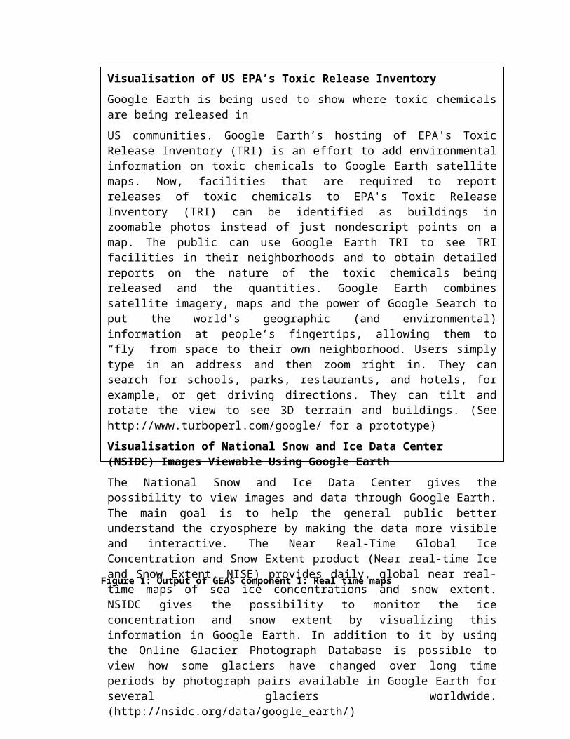
Figure 1: Output of GEAS component 1: Real time maps
KeyRed - volcanic eruptionsBlue - floodsYellow - earthquakesPink - cyclones.
Details are available by clicking on the markers; pop-up windows describe event type, location, date and time and provide links for additional information (as shown in the figure for cyclone).
2. GEAS COMPONENT 2: ENVIRONMENTAL HOTSPOTS ALERTS
“To protect our natural resource base in support of development” (2005 UN World Summit outcome)
At a time when the world community is striving to identify the impacts of humans actions on the planet’s life support system, powerful, time-sequenced satellite images from all parts of the world provide unique, visible and scientifically-convincing evidence that human actions are causing substantial harmful as well as constructive changes to the Earth’s environment and natural resource base. Such images clearly provide scientists and policy makers with original, scientifically valid assessment and early warning information on the recent and potential long-term consequences of human activities on

the biosphere, thereby assisting governments and civil society to identify and shape corrective and new measures for helping achieve sustainable development. By enhancing the visualization of scientific information on environmental change, satellite imagery will enable United Nations organizations to strengthen links with relevant institutions in developed countries, assist them in building the capacity of national-level institutions in developing countries, and help them to identify and report more effectively on their obligations under various international agreements.
The proof of the importance and impact of visual evidence of environmental change in hotspots is demonstrated by UNEP’s best selling publication One Planet, Many People: Atlas of Our Changing Environment, which shows before and after satellite photos to document changes to the Earth’s surface over the past 30 years. UNEP developed the Atlas in response to its mandate to keep under review the world environmental situation and to ensure that emerging environmental problems of wide international significance receive appropriate and adequate consideration by governments. The Atlas contains some astounding satellite imagery and illustrates the alarming rate of environmental destruction. Through the innovative use of some 271 satellite images, 215 ground photos and 66 maps, the Atlas provides visual proof of global environmental changes – both positive and negative – resulting from natural processes and human activities. Case studies include themes such as atmosphere, coastal areas, waters, forests, croplands, grasslands, urban areas, and tundra and Polar Regions. The Atlas demonstrates how our growing numbers and our consumption patterns are shrinking our natural resource base. We all are aware that our planet is changing; however, “seeing is believing” and “a picture is worth a thousands words.” Thus, the Atlas helps to connect the general public to complex scientific information by harnessing the potential of information technology tools.
This GEAS component will present time-series images from space that portray the nature and extent of our impact on the planet. An example of environmental change in hotspots is presented in the Figure below.

Figure 2: Mesopotamian Wetlands: Death of an Ecosystem (1973-2000)
GEAS will usher the material from the Atlas through Google Earth. Placing this type of information in the public eye is a major step forward in raising awareness about environmental change. The vehicle of Google is a compelling and engaging platform that will help to pique public interest in environmental issues. New data would be easily and continually made available. This platform could well become an effective communication channel for delivering local information about environmental change to a global audience of millions of people. The Google Earth interface of the Atlas of Our Changing Environment brings this knowledge to every person on the globe, available with just one click.

Figure 3: Google Earth Atlas of Our Changing Environment
Implementation of GEAS component 2
UNEP and partners will search science publication databases and science news services for reports of environmental change that lend themselves to illustration with remote sensing images. Again, UNEP will solicit the expertise and contacts available at GEOSS and others agencies for suggested study sites. In addition, users will be encouraged to submit suggestions.
UNEP will seek remote sensing imagery for each of the suggested locations. It will select those that best lend themselves to illustration with visually presented remote sensing from the list of suggestions that have imagery available. Finally, it will conduct research into the nature and cause of the visible change and write a short case study to accompany the images.
As with all components of the GEAS, these case studies will be actively disseminated by links and regular emails, sent to all service subscribers. These links will take the user to an interface in Google Earth where the remote sensing images and accompanying text will be displayed in context.
3. GEAS COMPONENT 3: ENVIRONMENTAL SCIENCE ALERTS

Policy makers should be regularly made aware of policy-relevant scientific findings published in peer-reviewed environmental science journals. Unfortunately, policy makers and the majority of practitioners may not have access to such information and generally do not have time to sort through the enormous number of articles published each month to find the information relevant to their location or topic of concern. Another problem is that it may take a year or two from the time a manuscript is submitted for publication to when it is actually published and even longer for such research results to be generally known through the standard publishing venues.
UNEP and partners will do this filtering for them by systematically searching various science literature databases and science news services for important developments in their area and package and disseminate this information in a convenient and accessible way to users. Gateways to other credible sources, such as the Encyclopedia of the Earth (under development), will be provided as well.
As an example, the EU Directorate-General Environment recently launched an Environment News Alert Service to disseminate research results in a more usable format for policy making and to help communicate environmental issues to the general public. This service provides scientific information about the main themes of the Environmental Action Programme so as to reinforce the links between science and policy. The service was built on the EU’s request for clear scientific information based on solid scientific evidence; the contents of the notification notes, however, are mainly focused on scientific results of either EU-funded projects or European research groups regarding European environmental issues relevant for the EU DG Environment policy making. The information is disseminated by email and on the EU web pages.
One additional area for action is helping developing countries to learnabout new publications. Simply because articles are on the web andavailable does not mean that they are known and will be accessed. UNEPshould promote more effective ways to publicize new research and results.UNEP could send out alerts on new journals, reports and articles toMinistries of Environments and appropriate universities and researchfacilities through its proposed Global Environmental Alert Service (GEAS). UNEP and partners will guide users in the access and search of scientific papers. UNEP’s GEAS will direct users to what they are looking for just simply by guiding and suggesting them websites of journals, research institutions and groups involved in the field of their interest.
In due course GEAS can provide online services on Journal access, Research online, Educational resources/ Powerpoints, Case studies on environmental solutions.
GEAS component 3 main outcomes can be synthesized in the following activities:
Science and policy briefs
Journal access
Research online
Educational resources/ PPT
Solutions case studies
Implementation of GEAS component 3
UNEP along with its partners will regularly scan major environmental journals for relevant articles. It will conduct database searches with a list of topics identified through a users’ survey, and will monitor environmental news sites for emerging topics and relevant environmental news. From these searches, it will select the most important and policy relevant information and report the findings.
These findings will be reported concisely, in layman’s language and without scientific jargon. In some cases, additional related articles and data will be sought to provide context for the major findings reported. In every case, the need to keep the information relevant to policy issues will be the foremost criterion in the selection of articles and information to be included in the briefing notes. These notes will be designed to serve as support for environmental decision making to “advocate and coordinate measure and action to tackle these problems and their causes, thereby reducing future risks” (UN Task Force on Environment and Human Settlements, June 1998).
As with the other components of GEAS, these short reports and briefing notes will be delivered through a subscription service based on user profiles tailored to specific regional and thematic interests. Policy makers and interested users will be encouraged and helped to subscribe. UNEP and partners will continually seek feedback as to content and delivery of the briefing notes to make them more convenient and more relevant.
A sample of a potential GEAS briefing note, representing the output of GEAS component 3, is shown below.
Neglected Research Dimension: Methane Emissions from Green Plants
BackgroundThe results of recent research published in the journal Nature documents a surprising discovery: in the presence of oxygen, green plants produce the greenhouse gas methane.
Methane is one of the largest contributors to global warming – second only to carbon dioxide. Its large contribution is due in part to its great potency in trapping heat in the Earth's atmosphere.
Emissions of methane have grown dramatically since pre-industrial times. Methane is emitted from both anthropogenic and natural sources. Anthropogenic activities include fossil fuel production, livestock enteric fermentation, manure management, rice paddies, biomass combustion, and waste management (EPA 2006). The Intergovernmental Panel on Climate Change (IPCC 2001) estimated that 60 per cent of global methane production is from anthropogenic activities.
Natural sources of methane are wetlands, gas hydrates, permafrost, termites, oceans, freshwater bodies, non-wetland soils, and wildfires (EPA 2006).

Until now, it was scientifically proven that methane was produced naturally in environments lacking oxygen by bacteria acting on vegetation in swamps and rice paddies. Studies on plant physiology and biochemistry, however, had not studied the possibility of methane emissions or lack thereof from plants in the presence of oxygen (Keppler and others 2006).
Results and conclusion
This recent discovery by scientists in Germany shows that plants worldwide produce millions of tonnes of methane in the presence of oxygen. This finding was contrary to previous thinking that methane could only be produced by plants in the absence of oxygen. It was also discovered that methane production doubles with every 10 ºC increase in temperature over the range of 30-70 ºC. This natural source may contribute almost one third of total methane emissions.
Other than lab results, arguments supportive of this discovery are the observance of plumes of methane above tropical forests, high levels of methane found in ice formed 2000 years ago when plants covered most of Earth’s surface, and reduction in the build-up of methane in the atmosphere probably due to global deforestation.
Policy Implications
This study has implications for the Clean Development Mechanism (CDM) of the Kyoto Protocol, which allows countries to offset part of their carbon dioxide emissions through afforestation projects. The discovery shows that the relationship between greenhouse gases and the environment is more complex than previously believed. This will make it difficult to quantify the sink capacity of the afforestation and reforestation projects in comparison with fossil fuel emissions.
Afforestation and reforestation projects for carbon dioxide sequestration may have a reduced net positive effect because in addition to acting as carbon sinks they can also act as methane sources. The authors of the research estimate that the success of reforestation programs for climate would be lessened by between one and four per cent. These findings suggest that the valuation of carbon credits for afforestation projects may need to incorporate the negative effects of methane production. In addition, these findings have implications for the global methane budget and “may call for a reconsideration of the role of natural methane sources in past climate change.” In particular, climate models, which previously failed to account for methane production from plants, and will need to be reevaluated.
References
EPA (2006). Methane. US Environmental Protection Agency http://www.epa.gov/methane/index.html [Accessed 30 January 2006]
IPCC (2001). Climate Change 2001: The Scientific Basis. Contribution of Working Group I to the Third Assessment Report of the Intergovernmental Panel on Climate Change http://www.grida.no/climate/ipcc_tar/wg1/index.htm [Accessed 30 January 2006]

Keppler, Frank, John T. G. Hamilton, Marc Braβ, Thomas Röckmann (2006). Methane emissions from terrestrial plants under aerobic conditions. Nature 439 (7073):187-91
Profiling System
The wealth of available environmental science and earth observation information can be overwhelming. Policy makers need to separate what is relevant to them from a sea of publications, websites, advocacy groups and news services. By allowing the user to define areas of interest, both thematically and geographically, UNEP and partners, through GEAS, help policy makers sort through this flood of information and become familiar and up-to-date about major environmental concerns.
The GEAS allows interested stakeholders and the public to request notification of environmental information relevant to them. Each user will be able to select notification by region and by theme. The general public can define their profile on-line via a link in the initial email invitation. For policy makers, UNEP staff will assist in establishing and maintaining their profiles through the use of personal visits, telephone surveys, email surveys or paper surveys, as is most appropriate for each policy maker. The profiling will provide identical access to information for both policy makers and the general public. Subscribers will be able to edit their profiles at anytime.
Conclusions
Getting environmental information to public and decision makers in near-real time mode is now in the realm of reality. UNEP's GEAS effort will provide people with online access to compelling and dynamic information about environmental changes as they occur. GEAS is a much-needed service. This vehicle will provide an engaging platform that will help mitigate damage from disasters and pique interest in environmental issues. New UNEP information could easily and continually be made available. This platform could well become the standard for delivery of information on any UN-related topic for any locale affected. One can easily imagine the BBC and CNN using the ‘UNEP Living Sources’ for describing world affairs. The long term vision is that eventually UNEP becomes a household word as the provider of environmental solutions to periodic routine societal queries. Related to this is the notion that the public should be able to click on an area of interest and find out what type of ecosystem he or she lives in, what the societal and economic values of that ecosystem’s goods and services are, what the ecosystem’s water quality is like, what other creatures live there and how they are faring, what is likely to change in the ecosystem in 10 years time, what the air quality is like today, among a myriad of other questions about environmental parameters. This is information that can be made available to answer public queries as a public good. UNEP considers this kind of service as enhancing Environmental Science on the Internet.

It is feasible that over time, we begin to change our everyday habits – from the coffee we drink in the morning to the way we get to work – because information gleaned from GEAS has clearly shown the implications our personal choices have on the planet.

ANNEX : Flow diagram of Global Environmental Alert Service (GEAS)


Architecture of GEAS-Component 1-Near-Real-Time Environmental Hazards Alerts


List of Acronyms:
CAP-Common Alerting Protocol
DG Environment-European Commission Directorate-General Environment
GDACS- Global Disaster Alert and Coordination System (by JRC)
GEO- Global Environment Outlook
GEOSS- Global Earth Observation System of Systems
HEWS-Humanitarian Early Warning Early Warning Service
ISDR-International Strategy for Disaster Reduction
JRC- Joint Research Center-European Commission, Directorate General
KML-Keyhole Markup Language
NOAA-National Oceanic and Atmospheric Organization
NSIDC-National Snow and Ice Data Center
NWS-National Weather Service
OEM- program for Email marketing and mailing list management
PHP- Hypertext Preprocessor
PPEW-Platform for the Promotion of Early Warning (ISDR)
RSS -Really Simple Syndication
UN-United Nations
UNEP-United Nations Environment Programme
USGS-U.S. Geological Survey
WFP-World Food Programme
XML -Extensible Markup Language

Appendix-A
An analysis of the performance of existing global alert systems
The potential impact of GEAS can be evaluated by the means of a performance analysis. This analysis assesses feasibility and compares the performance of some global alert systems: GEAS, WFP (World Food Programme), HEWS (Humanitarian Early Warning Service), JRC (Joint Research Center) and USGS (United States Geological Survey) warning services. The aim of this analysis is to show the rationale of GEAS’s design and to demonstrate how UNEP and partners through GEAS will coherently address a set of needs suggested by this comparative analysis of existing warning services.
The three areas of comparison used to evaluate the existing systems are:
Type of events covered
Variety of output/communication forms
Range of users served
The optimal warning service will be as comprehensive as possible in terms of content, output and range of users. GEAS aims to cover most environmental hazards at a global scale. It will deliver this information in a variety of user-friendly formats to reach the widest range of users. This advantage is strongly supported by the results of this analysis.
The following table shows the types of events covered by each existing warning service as well as the proposed GEAS. GEAS will provide an alert service for all possible natural events while USGS alert service provides information only on earthquakes.
Table 1: Comparative analysis related to the system coverage of natural events to help decide which system is the best for contents
Type of event Warning Systems
GEAS HEWS WFP JRC USGS
EarthquakesTsunamis
Severe weatherVolcanicEl NinoStormsFloods
DroughtsCyclones/Hurricanes
FiresLocust
Other Environmental
Issues

KeyTurquoise - GEASGrey - HEWSLight Green - WFPDark Blue – JRCForest Green-USGS
The following table compares the variety of output/communication types supported by each of the warning systems. Through GEAS, UNEP and partners will disseminate environmental hazard information through email, and/or web service alerts. Existing systems, such as WFP and HEWS, post the information on a web site and JRC sends emails, SMS and faxes to users. The JRC notification service is provided on a daily basis (Table 3). In addition, reviews of recent scientific research in areas relevant to environmental policy will be delivered by GEAS in briefing note and short report form.
Table 2: Comparative analysis related to the output provided by the warning systems to help decide which system is the best for type of output released (Note USGS notification service is only for earthquakes)
Output Warning Systems
GEAS JRC USGS WFP HEWS
Web serviceEmail
Briefing NotesReport
Fax/SMSKeyTurquoise - GEASGrey - HEWSLight Green - WFPDark Blue – JRCForest Green-USGS
The following table shows the variety of themes reported in the email notifications provided by the various warning systems. The only natural event notification provided by USGS service is earthquakes. HEWS and WFP offer no email notifications for natural events.
Table 3: Comparative analysis related to the content of email notification service provided by the warning systems to help decide which system is the best for contents of Email service

Email Notification Warning Systems
GEAS JRC USGS HEWS WFP
EarthquakeTsunami
Severe weatherVolcanicEl NinoStormsFlood
DroughtCyclones/Hurricanes
FireDisease outbreaks
FamineOther Environmental
Issues
LocustKeyTurquoise - GEASDark Blue – JRC
Forest Green-USGS
GEAS email notifications would be available to all organizations and individuals – USGS serves as wide a variety of users, however their notification service is only for earthquakes. JRC also operates a disaster coordination program together with several partners as UN-OCHA, UNOSAT and HEWSweb with the main aim at favoring real-time information exchange by all actors of the international disaster response community. As part of the coordination program, UN-OCHA provides an e-mail service to inform users about critical situation updates during disaster response operations.
Table 4: Results of the comparative analysis related to the users alerted by the warning systems to help decide which system is best for dissemination of information (Note USGS notification service is only for earthquakes).
Email Service Users Warning Systems
GEAS USGS JRC WFP HEWS
International OrganizationsHumanitarian Aid
Policy/Decision MakersCivil Society

KeyTurquoise - GEAS
Forest Green-USGS
Dark Blue – JRC
The results of the analysis show that UNEP and partners through GEAS will provide a more comprehensive service for content coverage, range of users and format of message alert compared to the performance of other existing warning services such as WFP, USGS, JRC and HEWS.

Part 2
Global Environmental Alert Service (GEAS)
Implementation Plan
1. Preamble
Empowering people with engaging environmental information in a near-real time mode is now in the realm of reality. Digital revolution has made it possible to connect instantaneously with billions of other people across the planet. Harnessing the power of the Internet, GEAS will build on UNEP’s existing infrastructure to enhance and accelerate the flow of information from scientific research, local knowledge and earth observation systems to environmental decision makers and the general public. Although much information and many data sets are currently available in the public domain, there is a need for a credible information broker that searches and packages the policy-relevant material and delivers that information in an easily understood format to the public and decision makers.
2. Purpose of this plan
The purpose of this Plan is to summarize the essential steps to be undertaken, by UNEP and partners such as research communities, intergovernmental, international, and regional organizations, to put in place a Global Environmental Alert Service (GEAS).
3. Vision
Everyone in the world should have access to information about what is happening to his or her environment.
4. Purpose and benefits
The long term vision of GEAS is that the public should be able to demarcate an area of interest and find out what is happening to their changing environment and what are consequences of choices they make everyday. Despite laudable efforts, the current situation with respect to the availability of existing alert systems is not optimal and more has to be done towards the development of an effective and usable alert system.

The Global Environmental Alert Service has three components that would support short- and long-term decision-making:
Component 1: Near Real-time Environmental Hazards AlertsGEAS will be a notification service that uses appropriate formats (email, web service with real-time maps) to alert people about environmental events in a timely fashion.
Component 2: Environmental Hotspots AlertsThrough change studies of photographs, satellite images, maps and narratives, GEAS will document visual evidence of site specific environmental changes resulting from natural processes, human activities and the interaction between them.
Component 3: Environmental Science Alerts
In order to bridge the gap between science and policy, GEAS will provide decision makers and interested users with policy-relevant scientific findings about the environment condensed into short reports and briefing notes
4.1 User involvement
GEAS will be demand driven, results oriented, coordinated, responsive in a timely way, and engage partners strategically. The goal is to enhance societal benefits of environmental data by making them accessible to all. The benefits of GEAS will be realized globally by the involvement of managers, policy makers, scientific community and civil society. Engagement of users in developing countries will enhance capacity building efforts.
GEAS will be a service tailored on users’ needs through a user survey as part of a profiling system. The GEAS allows interested stakeholders and the public to request notification of environmental information relevant to them. Each user will be able to select notification by region and by theme. The general public can define their profile on-line via a link in the initial email invitation. Subscribers will be able to edit their profiles at anytime.
In due course, an online GEAS community Forum will favor cooperation and exchange of expertise and knowledge. Researchers from developed countries will have the possibility to interact with researchers from developing countries providing technology support and meeting capacity-building needs at the country level. As an outcome, researchers from developing countries will have the opportunity to receive information and broaden their perspectives and scientific knowledge, i.e. “localization of global information”, at the same time researchers from developed countries will benefit from the cooperation by receiving local knowledge, i.e. “globalization of local information”.

5. Scope
Using a multi-scaled approach, GEAS will build on UNEP’s existing infrastructure to enhance and accelerate the flow of information from scientific research and earth observation systems to environmental decision makers and the general public. GEAS will directly contribute to UNEP’s efforts at providing evidence of environmental change by packaging and presenting scientifically credible information from around the globe to local users in near-real time, including national focal points in the environment ministries, in the form of regular briefing reports.
GEAS will intimately interact with global observation systems, including the Global Earth Observation System of Systems (GEOSS), and deliver relevant information gleaned from such observations of environmental events occurring around the globe. GEOSS will generate better information for decision-making, and GEAS will package such information to be understandable to policy makers and other users.
GEAS will promote use of international standards and protocols and collaborate with GEONETCast and others to support their effort to enhance delivery of data and information to users, especially in developing countries, though a global network of communication satellites. GEAS through GEONETCast and others will provide global coverage and use standard protocols to broadcast information worldwide.
6. Role of UNEP
The Bali Strategic Plan for Technology Support and Capacity-building stipulates the following cross cutting activities to fulfill the UNEP mandate:
5. Development of national research, monitoring and assessment capacity, including training in assessment and early warning;
6. Support to national and regional institutions in data collection, analysis and monitoring of environmental trends;
7. Access to scientific and technological information, including information on state-of-the-art technologies;
8. Education and awareness-raising, including networking among universities with programmes of excellence in the field of the environment.
GEAS will respond to the Bali plan by focusing around core areas of work where UNEP has leadership and can provide a "value added" service. UNEP and partners through GEAS will deliver responsive, flexible and cutting edge services that meet member governments’ needs and ensure phased delivery of the Bali Plan. UNEP will play following role:
UNEP as a credible authoritative sources of environmental information
Connecting producers and consumers of environmental data and information
UNEP as a source of information to media i.e. CNN, BBC etc.

Implementation of the Bali Plan on Capacity Building and Technology Support: Catalyze national actions for collection of data and provide public access to environmental information
Value added over Global Earth Observation System of Systems (GEOSS) products and services;
Promote accountability and transparency through ‘evidences’ and visualization tools;
7. Technical approach and Capacity Building
7.1 Technical Approach
To achieve a global, coordinated and effective alert service GEAS will undertake several steps. These steps are here summarized for each of the three components of GEAS that will be implemented in phases. Working with a selected range of partners will be crucial to maximizing the impact of UNEP's activities and making them felt on the ground.
1. GEAS COMPONENT 1: NEAR REAL-TIME ENVIRONMENTAL HAZARDS ALERTS
Identification of environmental issues of interest and concern
Identification of sources
Analysis of sources: credible, reliable, scientifically sound, supporting a standard format (such as CAP, RSS, XML, etc.).
System design and implementation for automatic streaming of information from sources and insertion of information in database
Alert database design and maintenance
Web service design and maintenance
Visualization: Google maps and Google Earth etc.
Alert Service: Design of alert system (Automated)
Identification of users and collection of emails
Email database design and maintenance
Development of a profiling system
Interaction with Media (through CAP alerts sent to TV and/or Radio, packaging of information into image and reports for TV/Radio/News specials)
Dissemination of alerts (Email, Media)
Archive design

GEAS COMPONENT 1: ROLE FOR UNEP REGIONS
Identification of regional/local environmental issues of interest and concern
Identification of regional sources
Identification of users and collection of emails
Interaction and cooperation with regional media services
Dissemination of alerts in regional language
2. GEAS COMPONENET 2: ENVIRONMENTAL HOTSPOTS ALERTS
Identification of environmental hotspots
Identification of sources
Satellite data retrieving
Analysis of satellite data
Packaging of change study
Archive database design and maintenance
Writing the narratives of the change study
Google Earth and Maps visualization
Web site design and maintenance
GEAS COMPONENT 2: ROLE FOR UNEP REGIONS
Identification of regional/local environmental hotspots
Writing the narratives of the change study (in regional language)
Dissemination of environmental changes studies
3. GEAS COMPONENT 3: ENVIRONMENTAL SCIENCE ALERTS
Identification of sources
Screening sources
Identification of scientific findings
Screening of findings
Identification and assessment of regional/local policy relevant environmental issues
Identification of policy relevant findings
Integration of material
Synthesis

Packaging
Email system design and maintenance (Manual)
Email database (common to component 1)
Profiling system (common to component 1)
Feed back system
Archive
GEAS COMPONENT 3: ROLE FOR UNEP REGIONS
Identification and assessment of regional/local policy relevant environmental issues
Identification of sources/findings
Identification of users
Translation of briefing reports to regional language
Dissemination to regional users
Foster cooperation with local governments
7.2 Capacity Building efforts
Capacity building efforts are addressed by each of GEAS’ components:
GEAS COMPONENT 1: NEAR REAL-TIME ENVIRONMENTAL HAZARDS ALERTS
Development of national research, monitoring and assessment capacity, including training in assessment and early warning
Organization of training courses for local decision makers and communities
Education and awareness rising, including networking among universities with programmes of excellence in the field of the environment.
GEAS COMPONENET 2: ENVIRONMENTAL HOTSPOTS ALERTS
Support to national and regional institutions in data collection, analysis and monitoring of environmental trends
Access to scientific and technological information, including information on state-of-the-art technologies
Identifying local scientist for UNEP Visiting Scientist program
Organization of seminars, meetings and courses for trainings.

GEAS COMPONENT 3: ENVIRONMENTAL SCIENCE ALERTS
Organization of seminars/conferences for policy makers/scientists
Education and awareness rising, including networking among governments in the field of the environment.
Education and awareness rising, including networking among universities with programmes of excellence in the field of the environment.
Journal access
Research online
Educational resources/ Powerpoints
Solutions case studies
8. Resource requirements for GEAS implementation
Start-up resources required for the real-time service alert service (component 1) have very little overlap with the other two components. Also, once the alert service is operational, it will automatically stream much of its content from the primary sources of alert information. On the other hand, the change studies and science digests (outcomes of the components 2 and 3 of GEAS) will require significant resources to commence, and their continuing operation, particularly in terms of content production, will require resources on a sustained basis. For these reasons, it is useful to look at the resources required for the real-time alert service independently and to look at the resources needed for the other two components together.
For the component 1 (alert service), the primary tasks are 1) acquiring the necessary software and building the architecture to automate the delivery of real-time data to alert service subscribers and 2) development of the website/web pages that will support those alerts. Software costs should be minimal. Some or all of the needed software may be available as open data software at no cost. The largest investment of resources will be identifying credible sources of near-real time information, programming, configuration and web page design.
The creation and maintenance of an email database is the primary point of overlap between the three components – the alert service, the briefing notes and the change study services. Resource requirements for collecting and expanding the list of subscribers will entirely depend on the priority placed on reaching the maximum number of users. The minimum requirement would result from using the UNEP email address list and other list servers and soliciting subscriptions on the website(s).
For the environmental science briefing notes and the environmental change case studies, the ongoing production of content will require the largest share of resources. Depending on the number of unique profiles, differing amounts of content will be required to ensure that each release contains content relevant to at least a large fraction, if not all, of

the subscribers. Time requirements related to each release involves collecting the content, sorting the content to the profiles and sending the emails Additional time will be required to conduct user surveys, respond to user feedback, find and add email addresses and maintain the system. Software capabilities may reduce the need for some of these resources by automating the sorting of content to user profiles and simplifying user surveys.
Further development of an archive tool, initially developed to organize studies featured in the One Planet, Many People project could also be used to organize and manage data for the change studies displayed in Google Earth and the change studies are displayed independently on UNEP’s web page.
Estimated Annual Budget
One project manager $150,000
One remote sensing specialist $100,000
One GIS analyst $100,000
One software engineer $100,000
One data base analyst $100,000
One environmental analyst $100,000
One Science writer $100,000
Office space, Travel, H/w, S/w $150,000
Capacity building: - workshop etc. $300,000
Total: $ 1.2 million
9. GEAS Organizational Structure
Advisory Committee
An advisory committee is proposed for:
Providing advices and guidance.
Helping shape future programs and activities.
Partners
GEAS works with several partners such as research networks, UNEP regional offices, private sector and institutions active in environmental protection. This cooperation allows

truly reaching out communities, having interest in providing public access to environmental information and enhancing UNEP capacity-building efforts.
Secretariat
A core group will coordinate various and activities and delivery of information.
10. Phased implementation plan
The following implementation guidelines are being used to develop the Global Environmental Alert Service (GEAS). The service is being implemented in phases.
Phase 1 will be the initial release of the service. In particular, during phase 1 the component 1 will integrate information from a limited number of sources and a first simplified web service will be implemented to disseminate this information. The email alert service will be developed in phase 3. In phase 1, component 2 will include a consistent number of change case studies, released through web services and Google Earth.
Additional features will be added to component 1 and 2, in Phase 2 and 3, once the initial service is operational.
Component 3 and alerts email service will be implemented in phase 3.
Note: Phase 1 is ongoing, component 2 is being developed and component 2 is completed. Once phase 1 is concluded, phase 2 will be implemented.
10.1 Phase 1
Note phase 1 is an ongoing phase: for component 1 tasks 1 to 4 have been completed while tasks 5 to 8 are still ongoing. Phase 1 component 2 has been completed.
GEAS COMPONENT 1: NEAR REAL-TIME ENVIRONMENTAL HAZARDS ALERTS
Tasks 1-2-3 for SOURCES:
Identification of environmental issues of interest and concern (Completed)
Identification of sources (Completed)
Analysis of sources: credible, reliable, scientifically sound, supporting a standard format (such as CAP, RSS, XML, etc.). (Completed)
Task 4: SYSTEM DESIGN: System design for automatic streaming of information from sources and insertion of information in database (Completed)
(Task 5: 1 month to complete) SCRIPTS: Implementation of software for design for automatic streaming of information from sources and insertion of

information in database (for first 5 sources: cyclones, fires, earthquakes, floods, volcanic eruptions) (Ongoing-add floods and fires for Brazil and South Africa)
(Task 6: 2 month) DATABASE: Alert database design (Add floods table and fires for Brazil and South Africa)
(Tasks 7: 2 months)MAPS: Visualization: Google maps and Google Earth etc. for the first 5 sources (Ongoing)
(Task 8: 1 month) WEB SERVICE: Main page design and implementation (Ongoing)
PHASE 1
COMP.1 1 MONTH 1 MONTH 1 MONTH
TASKS
1-2-3: SOURCES COMPLETED COMPLETED COMPLETED
4: SYSTEM DESIGN COMPLETED COMPLETED COMPLETED
5: SCRIPTS FOR DATA
STREAMING
COMPLETED COMPLETED COMPLETED ADD
FLOODS-FIRES
6: ALERT DATABASE
DESIGN
ADD FLOODS-
FIRES
7: VISUALIZATION-GMAPS
AND GEARTH
ONGOING
8: WEBSERVICE: MAIN
PAGE
ONGOING
GEAS COMPONENT 2: ENVIRONMENTAL HOTSPOTS ALERTS
Phase 1 for component 2 is completed, for this reason phases table has been omitted. The following steps have been implemented to complete the phase 1 of component 2:
Identification of environmental hotspots
Identification of sources
Satellite data retrieving
Analysis of satellite data
Packaging of change study
Archive database design and maintenance
Writing the narratives of the change study

Google Earth and Maps visualization
Web site design and maintenance
10.2 Phase 2 (6 months)
GEAS COMPONENT 1: NEAR REAL-TIME ENVIRONMENTAL HAZARDS ALERTS
(Task 1: 3 months) SCRIPTS: Implementation of software for design for automatic streaming of information from sources and insertion of information in database (for additional sources: floods, air quality, water level of lakes, droughts, and atmosphere and climate themes).
(Task 2: 2 months) DATBASE: Alert database design (for the additional sources) and maintenance
(Task 3: 2 months) MAPS: Visualization: Google maps and Google Earth etc. for the additional sources and background layers
(Task 4: 2 months) WEB SERVICE: design, implementation (additional web pages) and maintenance.
PHASE 2 (6 MONTHS)
COMP.1 1 MONTH 1 MONTH 1 MONTH 1 MONTH 1 MONTH 1 MONTH
TASKS
1: SCRIPTS FOR DATA STREAMING
2: ALERT DATABASE DESIGN
3: VISUALIZATION-GMAPS AND
GEARTH
4: WEBSERVICE
GEAS COMPONENT 2: ENVIRONMENTAL HOTSPOTS ALERTS
Note that tasks 9 to 17 are repeated continuously throughout the operational life of the component. Timing for tasks is flexible.
Repeat tasks listed in Phase 1 for component 2, for new environmental hotspots

PHASE 2 (6 MONTHS)
COMP.2
TASKS
9-10: HOTSPOTS AND SOURCES
11: DATA
12: ANALYSIS
13: PACKAGING
14: DATABASE
15: NARRATIVES
16: VISUALIZATION
17: WEB SERVICE
10.3 Phase 3 (6 months)
GEAS COMPONENT 1: NEAR REAL-TIME ENVIRONMENTAL HAZARDS ALERTS
(Task 1: 3 months) SCRIPTS: Implementation of software for design for automatic streaming of information from sources and insertion of information in database (for remaining sources).
(Task 2: 2 months): DATABASE: Alert database design (for the additional sources) and maintenance
(Task 3: 2 months): VISUALIZATION AND WEB SERVICE: Google maps and Google Earth etc. for the additional sources
(Task 4: 4 months) USERS: Identification of users and collection of emails (for Email Alert Service)
(Task 5: 2 months) USERS EMAIL DATABASE: design and maintenance
(Tasks 6-7: 6 months) Development of a profiling system
Email Alert Service (Automated): Email system design and implementation
(Task 8-9: 3 months) Archive design (for component 1)
Interaction with Media (through CAP alerts sent to TV and/or Radio, packaging of information into image and reports for TV/Radio/News specials)

PHASE 3 (6 MONTHS)
COMP.1 1 MONTH 1 MONTH 1 MONTH 1 MONTH 1 MONTH 1 MONTH
TASKS
1: SCRIPTS FOR DATA STREAMING
2: ALERT DATABASE DESIGN
3: VISUALIZATION AND WEBSERVICE
4: USERS
5: USERS DATABASE
6: PROFILING SYSTEM
7: EMAIL SERVICE
8: ARCHIVE
9: MEDIA
GEAS COMPONENT 2: ENVIRONMENTAL HOTSPOTS ALERTS
Repeat tasks listed in Phase 1 for component 2, for new environmental hotspots
GEAS COMPONENT 3: ENVIRONMENTAL SCIENCE ALERTS
Note for tasks 12 to 17 no timing is given is a continuous process throughout the operational life of the component.
(Task 11: 3 months): Identification of sources
(Task 12-17: 3 months): Screening sources
Identification and assessment of regional/local policy relevant environmental issues
Identification of policy relevant findings
Integration of material
Synthesis
Packaging
(Task 18: 6 months): EMAIL SYSTEM: design and maintenance (Manual)
(Task 19) Email database (common to component 1)
(Task 20) Profiling system (common to component 1)

(Task 21: 3 months): FEED BACK system
(Task 22: 3 months): ARCHIVE
PHASE 3 (6 MONTHS)
COMP.3 1 MONTH 1 MONTH 1 MONTH 1 MONTH 1 MONTH 1 MONTH
TASKS
11: SOURCES
12-17: INTEGRATION, SYNTHESIS
AND PACKAGING
18: EMAIL SYSTEM DESIGN
19: EMAIL DATABASE
(COMPLETED IN PHASE 2 FOR COMP.1)
20: PROFILING SYSTEM
(COMPLETED IN PHASE 2 FOR COMP.1)
21: FEEDBACK SYSTEM
22: ARCHIVE
Table 5: Phase 1 Sources for Alerts Component (1): “Extreme Events” Sub-themes
Sub-theme Data Source Parameters Update Frequency
Cyclones University of Hawaii
Most recent data archive
Location (lat, long); name; date; time; wind speed; category; pressure; type of event (tropical depression, hurricane, etc).
3 hours
Earthquakes USGS Location (lat, long); date; time; magnitude; depth; USGS id; description
20 minutes
Fires University of Maryland
Location (lat, long); date; time; temperature; certainty.
Daily
Brazil-CPTEC Link to map Daily
South Africa-WebFire Mapper
Link to map Daily

Floods Dartmouth Flood Observatory – Surface Water Watch
Location (lat, long); Country; River; date;time; estimated discharge; status (1=low flow, 2=normal flow, 3=flood, 4 = major flooding)
Daily
Volcanic Eruptions
Smithsonian Institute
Location (lat, long); description; new eruption or continuing
Daily
Table 6: Phase 2 and 3 Themes for Alerts Component (1)
Theme Data Source Parameters Update Frequency
Background Layers
Day-Night Image Layer in Google Earth
Population Density:
CIESIN population density
Population projections 2025:
Population Action International and Columbia University
Static layer in Google Earth
Administrative Boundaries Layer in Google Earth and Google Maps
Environmental Themes
Atmosphere and Climate
Precipitation Change:
IRI – Precipitation
Date, Location. Daily
Water availability
USDA- -Lake’s Level Monitoring
Location of lakes, level (m)
10 days
Sea Height Anomalies
NOAA- - Near-real-time AltimeterGoogle Earth Layer Every
2 days
IRI
Ocean temp anomalyGoogle Earth Layer

Droughts worldwide -
Benfield Hazard Research CentreCountry; (maybe
description from “drought news”) and the above link to the map. Add as a Google Earth layer (available on the website)
Monthly
Melting Glaciers-
NSIDC-Near Real-Time SSM/I EASE-Grid Daily Global Ice Concentration and Snow Extent
Add as a Google Earth layer (available on the website)
or order data: http://nsidc.org/data/nise1.html
Daily
Floods-
Dartmouth Flood Observatory – Surface Water Watch
Location (lat, long); Country; River; date;time; estimated discharge; status (1=low flow, 2=normal flow, 3=flood, 4 = major flooding)
Daily
Heat Waves-
NWS- Excessive Heat Outlooks
Link for US to the NWS page
Daily
Temperature Rise:
SST
Google Earth Layer
Carbon Tracker-NOAA-Carbon Emissions monitoring (2000-2006)
Links to carbon flux time-series for each continent
Water Vapor (MODIS)
OMI-Total Ozone Column
Global Ozone Field
Daily
Coastal and Marine
NASA – Chlorophyll
MODIS - Chlorophyll Daily
Forests INPE-Monitoring Amazon Deforestation
Provide link to map (Note should register to access the map).
Note data available is for 2004-2006

Extreme Events
See
Tsunamis - NOAA RSS
Tsunamis - PTWC (tsunami bulletins) Interested areas; Time issued, description
Pollution U.S. Air Quality - EPA – AirNow
Air Quality
Ozone
Particles
Link to EPA AirNow website
Daily
UK Air Quality Network Link to website Daily
EEA-Air quality for EU Link to website
SEPA-China Air quality Link to website
EPD-Hong Kong Air Quality Link to website Daily
Department-Ministry of Natural Resources and Environment
Bangkok air quality
Regional air quality data
Link to website Daily
Environment Protection Authority - Department of Environment and Conservation – Australia
Link to website Daily
Ministry of Environment – Ontario Link to website Daily
City of Cape Town air quality network - Cape Town South Africa
Link to website 3 hours
OMI
Or http://disc.gsfc.nasa.gov/Aura/OMI/omaeruv.shtml
Aerosol Index, Aerosol Optical Depth
Daily
Trabsboundary Movement of pollutants
OMI-Aerosol Type
Schiamachy-Absorbing aerosol index
Daily
Other WHO- Reports on crises and emergencies
Country, Link
FAO GIEWS (Global Information Country, Date, Link Mont

and Early Warning System on Food and Agriculture)
hly
Reports on disease outbreaks Country, Link
Map of Malaria Risk for Africa Link to the map 10 days