Embed Size (px)
Citation preview
© WJEC CBAC Ltd.
GCE MARKING SCHEME
GEOLOGY AS/Advanced
SUMMER 2013

© WJEC CBAC Ltd.
INTRODUCTION The marking schemes which follow were those used by WJEC for the Summer 2013 examination in GCE GEOLOGY. They were finalised after detailed discussion at examiners' conferences by all the examiners involved in the assessment. The conferences were held shortly after the papers were taken so that reference could be made to the full range of candidates' responses, with photocopied scripts forming the basis of discussion. The aim of the conferences was to ensure that the marking schemes were interpreted and applied in the same way by all examiners. It is hoped that this information will be of assistance to centres but it is recognised at the same time that, without the benefit of participation in the examiners' conferences, teachers may have different views on certain matters of detail or interpretation. WJEC regrets that it cannot enter into any discussion or correspondence about these marking schemes. Page GL1 1 GL2 5 GL3 19 GL4 25 GL5 34
© WJEC CBAC Ltd.
GCE Geology – GL1
Summer 2013
Q.1 (a) (i) Ordovician [1]
(ii) Evolved/appeared in (late) Cambrian (1)
Achieved maximum diversity in (early) Ordovician (1)
Extinct in early Devonian (1) [3]
(iii) Trilobites evolved earlier / Graptolites later (1)
Trilobites showed greater diversity / Graptolites not as diverse (1)
Trilobites decline more rapid initially, then gradual / Graptolites gradual decline (1)
Trilobites extinct later – Permian / Graptolites extinct first-Devonian (1)
2 max [2]
(iv) Evolved rapidly (1) through many short lived stages (1)
Facies free – not restricted to a single environment (1)
Very abundant / common (1)
Easy to identify (1)
Widespread / worldwide distribution (1)
Description of evolution pattern theca/stipes (1)
Hard parts suitable for preservation (1)
2 max [2]
(b) (i) Pygidium – accept thorax [1]
(ii) Pyrite / Iron Pyrite [1]
(iii) Petrification/Petrifaction/Pyritisation (1) R – reserved mark
Original hard parts dissolved away (1)
Replaced by minerals (1) precipitated from solution (1)
Credit reference to formation of mould then cast
R + 2 max [3]
(iv) Death assemblage (1) Not as Life Assemblage, statement is false (1) R
Reference to process-transport / moved / washed / eroded (1) R
Fossils are incomplete/broken (1)
Fossils sorted / all similar size (1)
Only one fossil group is present (1)
All fossils same age/size not a range from juveniles to adult (1)
Fragments aligned (1)
2R + 1 max [3]
Total 16 marks
© WJEC CBAC Ltd.
Q.2 (a) (i) Gneiss [1]
(ii) The folds strike north–south (1)
The fold limbs have roughly equal angles of dip (1)
Asymmetrical synclines and anticlines (limbs of equal length) (1) [3]
(b) (i) Reverse fault/Thrust Fault (1)
Hanging wall upthrown / footwall downthrown (1)
Compression/crustal shortening (1)
Fault plane dips less than 45° / low angle = thrust (1)
Metamorphic rocks (older) now on top of/overly younger sedimentary rocks (1)
3 max [3]
(ii) Fault breccia (1) angular, poorly sorted rock (1)
Fault line drag (1) beds bent upwards/downwards next to fault as it moves (1)
Marker beds (1) characteristic colour / mineral / fossil content to estimate throw (1)
Slickensides (1) grooves / scratches on fault plane indicates direction of movement (1)
Change in rock type – regional metamorphic rock overlies sedimentary (1) and explanation (1)
Presence of a spring (1) Fault scarp (1) Gully / Trench (1) and elaboration (1)
Find the outcrop of the dyke / marker bed to the west (1)
2 max [2]
(c) Unconformity (1) R
Shale and rocks below are folded (1)
Conglomerate horizontal / sub-horizontal / unconformable (1)
Erosion surface / cross cutting surface (1)
R + 2 max [3]
(d) False – Gneiss is the oldest NOT the youngest (1)
Gneiss is a foliated regional metamorphic rock – other rocks not metamorphosed (1)
Gneiss has been thrust over onto younger rocks (1)
Gneiss fault boundary – can’t tell / don’t know – may be older (1)
True – Dolerite is the youngest (1) Younger than the rocks it cuts through (1)
It is discordant cutting through all the sedimentary rocks (1)
4 max [4]
Total 16 marks
© WJEC CBAC Ltd.
Q.3 (a) (i) Ocean ridge symbol drawn within the age band 0-5 Ma (1)
Ocean trench symbol drawn offshore and parallel to / along the coastline of west coast of South America (1) [2]
(ii) Symmetrical pattern / Repeated pattern (1)
Increases in age to the west and the east / A to B gets younger and B to C gets older (1)
Credit reference to ages (1)
2 max [2]
(b) (i) 700 km in 30 million years = 70000000/30000000 (1)
2.33 cm per year (1) (accept 2.2 to 2.5) [2]
(ii) Spreading rate changed at 30 Ma (1)
Faster 30-42 Ma (6.5 cm per year), Slower 0-30 Ma (2.33 cm per year) (1) [2]
(iii) Radiometric / Radioactive / Radioisotope dating (1)
Named method Rb/Sr, K/Ar, Ur/Pb (1)
Reference to decay of unstable radioactive isotopes / parent-daughter / half-life (1)
Used on igneous rocks / basalts (1)
2 max [2]
(c) Subduction (or description) (1) of oceanic / mafic crust / lithosphere / plate (1)
Partial melting (1) R
Of mantle wedge / subducted plate (1)
Contamination / assimilation of xenoliths / continental material (1)
Credit reference to release of water from subducting slab to initiate partial melting (1)
R + 2 max [3]
Total 13 marks
© WJEC CBAC Ltd.
Q.4 (a) (i) 2 or 3 sets of joints (1)
Horizontal joints (1) Vertical joints (1)
Joints intersect at right angles / grid pattern (1)
Unevenly spaced, credit reference to spacing measurements (1)
2 max [2]
(ii) Cooling and contraction (1)
Pressure release / dilatation / unloading (1) 1 max [1]
(iii) Freeze-thaw activity or frost shattering (1)
Water enters joints, freezes and expands by 9% in volume (1)
Internal stresses set up within the rock (1)
Process repeated many times – rock weakened and breaks apart (1) R
Credit reference to insolation / exfoliation / pressure release and explanation
R + 2 max [3]
(b) (i) Quartz [1]
(ii) Size – in the range 1 to 10mm (1)
Shape – angular / subangular / sub-rounded (1)
Sorting – moderately sorted / poorly sorted (1) – no credit for well sorted [3]
(iii) Hydrolysis of feldspar / mica to form clay / reference to chemical weathering (1)
Quartz harder than feldspar and mica (1)
Quartz has no cleavage but feldspar / mica have cleavage (1)
Quartz is unreactive and is the only mineral that remains (1)
Credit examples – feldspar-kaolinite / china clay, biotite mica / chlorite (1)
Clay minerals – lighter, washed away / blown away / removed (1)
2 max [2]
(iv) False – unlikely to be Aeolian because:
Too coarse (1) expect arenaceous 0.5-1.0mm (1) pitted / frosted (1)
Too angular (1) expect well rounded, spherical, millet seed shaped (1)
Too poorly sorted – wind can only move a very narrow range of particle sizes (1)
Short transport – still angular / poorly sorted / fluvial / alluvial (1)
– no credit for marine or glacial
3 max [3]
Total 15 marks

WJEC
May 2013
1212/01
AS GEOLOGY GL2a
Mark Scheme
Notes:
This scheme shows the minimum acceptable answer(s) for each mark point. It cannot give every possible alternative so that an equivalent phrasing/drawing
should be accepted; use your professional judgement, but if in doubt, seek guidance from the e-mail address [email protected] (quoting your name and
centre number).
Marking needs to take into account the quality of communication used. The nature of this paper means that continuous prose is
not compulsory – answers given in note/diagram form are just as acceptable. Correct spelling of geological terms is desirable; use your
professional judgement as to how close the candidate is!
A forward slash, /, indicates an alternative response; brackets, ( ), indicate a more complete response but is not awarded further credit.
Always mark in red ink and ensure that every page has some ink on it to show that you have read it, even if no marks have been awarded.
Do not correct students’ work.
Instructions for marking “ticked boxes” are given where appropriate within this mark scheme.
Put a tick close to the key word, phrase or drawing which gains one mark.
Please include annotation shown in scheme to confirm which marks have been awarded (e.g. C for crystalline, Sc for scale etc.)
on questions 1(a), 2(a)(i) and 6. See marked example.
Write the total for each part-question in the margin close to the brackets showing the available mark.
Do not exceed the total for each part-question and do not re-distribute marks between sections.
Write the question total in the box at the end of each question and transfer this to the front cover.
Insert the total for the paper on the front cover.
A marked example is available for download from the WJEC secure website
David Evans
Principal Moderator
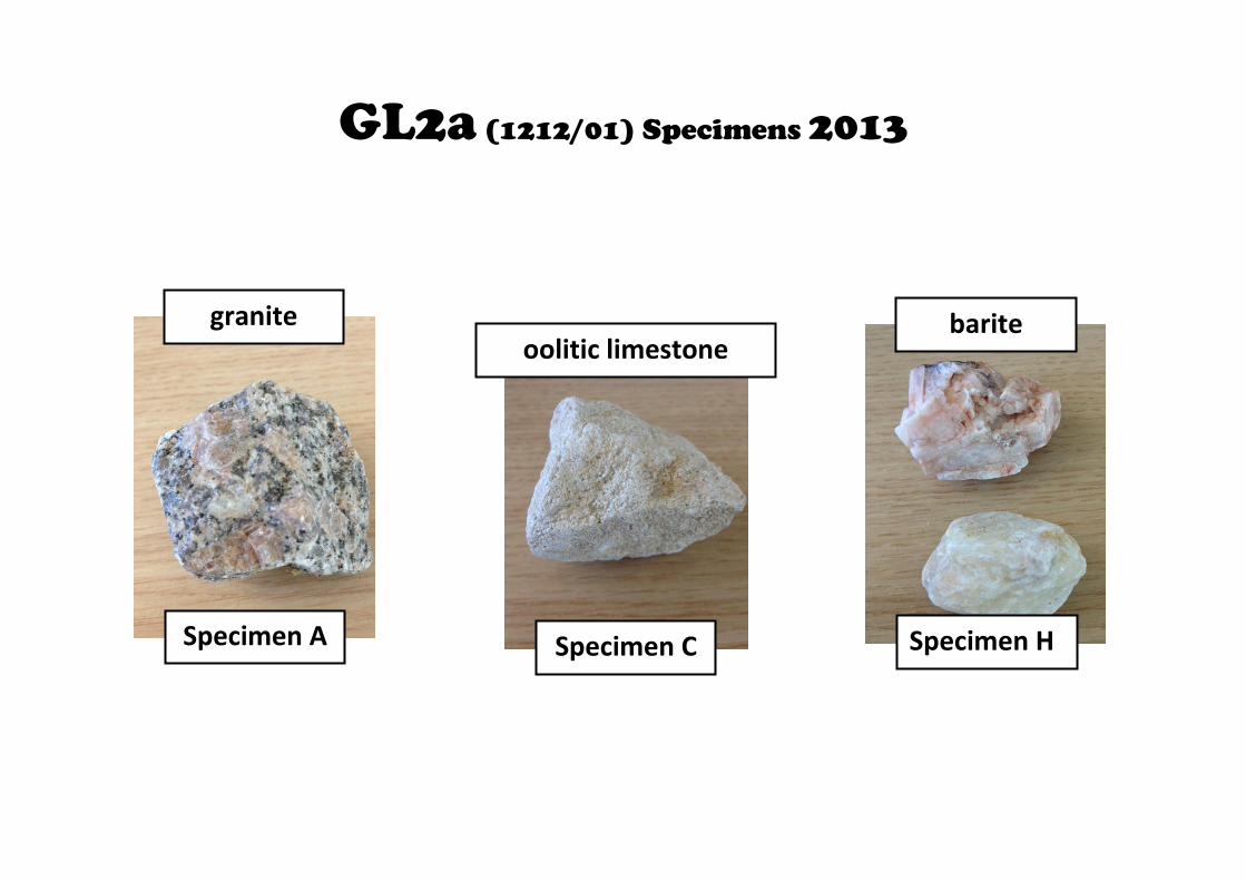
GL2a (1212/01) Specimens 2013
Specimen C Specimen H
barite oolitic limestone
Specimen A
granite
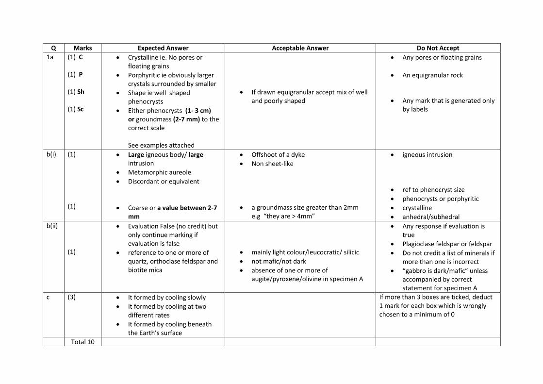
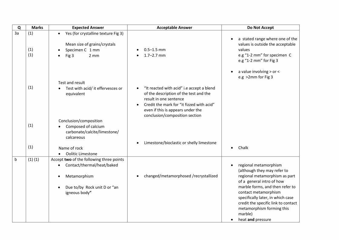
Q Marks Expected Answer Acceptable Answer Do Not Accept
1a (1) C (1) P (1) Sh (1) Sc
Crystalline ie. No pores or floating grains
Porphyritic ie obviously larger crystals surrounded by smaller
Shape ie well shaped phenocrysts
Either phenocrysts (1- 3 cm) or groundmass (2-7 mm) to the correct scale See examples attached
If drawn equigranular accept mix of well and poorly shaped
Any pores or floating grains
An equigranular rock
Any mark that is generated only by labels
b(i) (1) (1)
Large igneous body/ large intrusion
Metamorphic aureole
Discordant or equivalent
Coarse or a value between 2-7 mm
Offshoot of a dyke
Non sheet-like
a groundmass size greater than 2mm e.g “they are > 4mm”
igneous intrusion
ref to phenocryst size
phenocrysts or porphyritic
crystalline
anhedral/subhedral
b(ii) (1)
Evaluation False (no credit) but only continue marking if evaluation is false
reference to one or more of quartz, orthoclase feldspar and biotite mica
mainly light colour/leucocratic/ silicic
not mafic/not dark
absence of one or more of augite/pyroxene/olivine in specimen A
Any response if evaluation is true
Plagioclase feldspar or feldspar
Do not credit a list of minerals if more than one is incorrect
“gabbro is dark/mafic” unless accompanied by correct statement for specimen A
c (3) It formed by cooling slowly
It formed by cooling at two different rates
It formed by cooling beneath the Earth’s surface
If more than 3 boxes are ticked, deduct 1 mark for each box which is wrongly chosen to a minimum of 0
Total 10
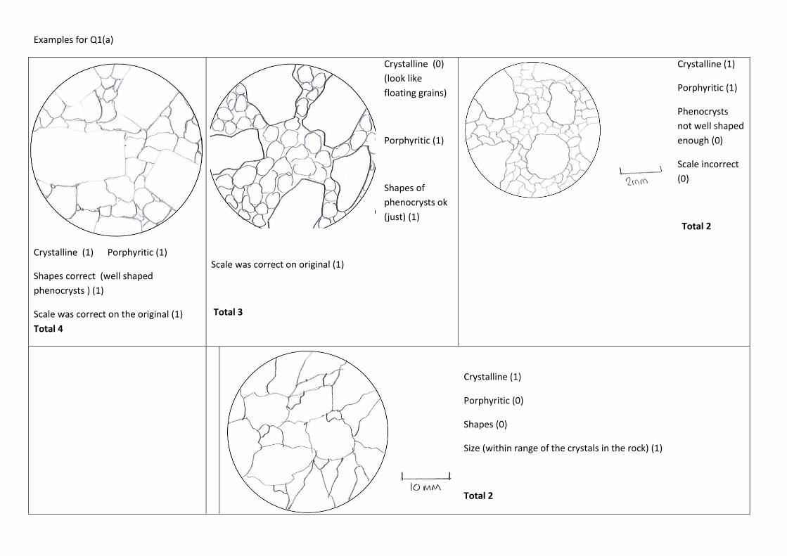
Examples for Q1(a)
Crystalline (1) Porphyritic (1)
Shapes correct (well shaped
phenocrysts ) (1)
Scale was correct on the original (1)
Total 4
Crystalline (0)
(look like
floating grains)
Porphyritic (1)
Shapes of
phenocrysts ok
(just) (1)
Scale was correct on original (1)
Total 3
Crystalline (1)
Porphyritic (1)
Phenocrysts
not well shaped
enough (0)
Scale incorrect
(0)
Total 2
Crystalline (1)
Porphyritic (0)
Shapes (0)
Size (within range of the crystals in the rock) (1)
Total 2

Crystalline (1)
Phenocrysts (1)
Shape of phenocrysts (1)
Scale (1)
N.B. The diagram does not have to fill the
entire circle
N.B There is no credit for labels. Do not credit any features whch are generated by labels. Mark only what is drawn

Q Marks Expected Answer Acceptable Answer Do Not Accept
2a(i) (1) Sc (1) Sh (1) B (1) F
Drawn to correct scale (it should fill box vertically)
Correct ratio of “height” to width (ie it looks correct rather than too fat or too elongate) and relatively accurate shape (see examples attached) (be relatively generous for shape)
Shows top edge of brachial valve
Shows the foramen
Allow a minimum “height” of 7.5 cm and maximum of 10 cm (which will be just longer than the box)
a(ii) (1) 2 valves of unequal size If more than 1box is ticked, deduct 1 mark for each box which is wrongly chosen to a minimum of 0
b (1) Brachiopod
Total 6

Examples for Q2(a)(i)
Scale correct (fills box vertically) (1)
Ratio and shape correct (1)
Top edge of brachial valve shown (1)
Foramen shown (1)
Total 4
Scale incorrect (0)
Ratio and shape (shape not good enough) (0)
Top edge of brachial valve shown (1)
Foramen shown (1)
Total 2
Scale correct (fills box enough vertically: ignore x1 in the box)
(1)
Ratio and shape (too thin) (0)
Top edge of brachial valve shown (1)
Foramen shown (1)
Total 3

Scale correct (fills box enough vertically) (1)
Ratio and shape correct enough. (Be relatively
generous on shape) (1)
Top edge of brachial valve shown (1)
Foramen shown (1)
Total 4
Scale incorrect (0)
Ratio and shape (shape good enough) (1)
Top edge of brachial valve shown (1)
Foramen shown (1)
Total 3
Scale correct (fills box enough vertically) (1)
Ratio and shape (shape good enough) (1)
Top edge of brachial valve shown (1)
Foramen not complete (0)
Total 3
Q Marks Expected Answer Acceptable Answer Do Not Accept
3a (1) (1) (1) (1) (1) (1)
Yes (for crystalline texture Fig 3) Mean size of grains/crystals
Specimen C 1 mm
Fig 3 2 mm
Test and result
Test with acid/ it effervesces or equivalent
Conclusion/composition
Composed of calcium carbonate/calcite/limestone/ calcareous
Name of rock
Oolitic Limestone
0.5–1.5 mm
1.7–2.7 mm
“It reacted with acid” i.e accept a blend of the description of the test and the result in one sentence
Credit the mark for “it fizzed with acid” even if this is appears under the conclusion/composition section
Limestone/bioclastic or shelly limestone
a stated range where one of the values is outside the acceptable values e.g “1-2 mm” for specimen C e.g “1-2 mm” for Fig 3
a value involving > or < e.g >2mm for Fig 3
Chalk
b (1) (1) Accept two of the following three points
Contact/thermal/heat/baked
Metamorphism
Due to/by Rock unit D or “an igneous body”
changed/metamorphosed /recrystallized
regional metamorphism (although they may refer to regional metamorphism as part of a general intro of how marble forms, and then refer to contact metamorphism specifically later, in which case credit the specific link to contact metamorphism forming this marble)
heat and pressure
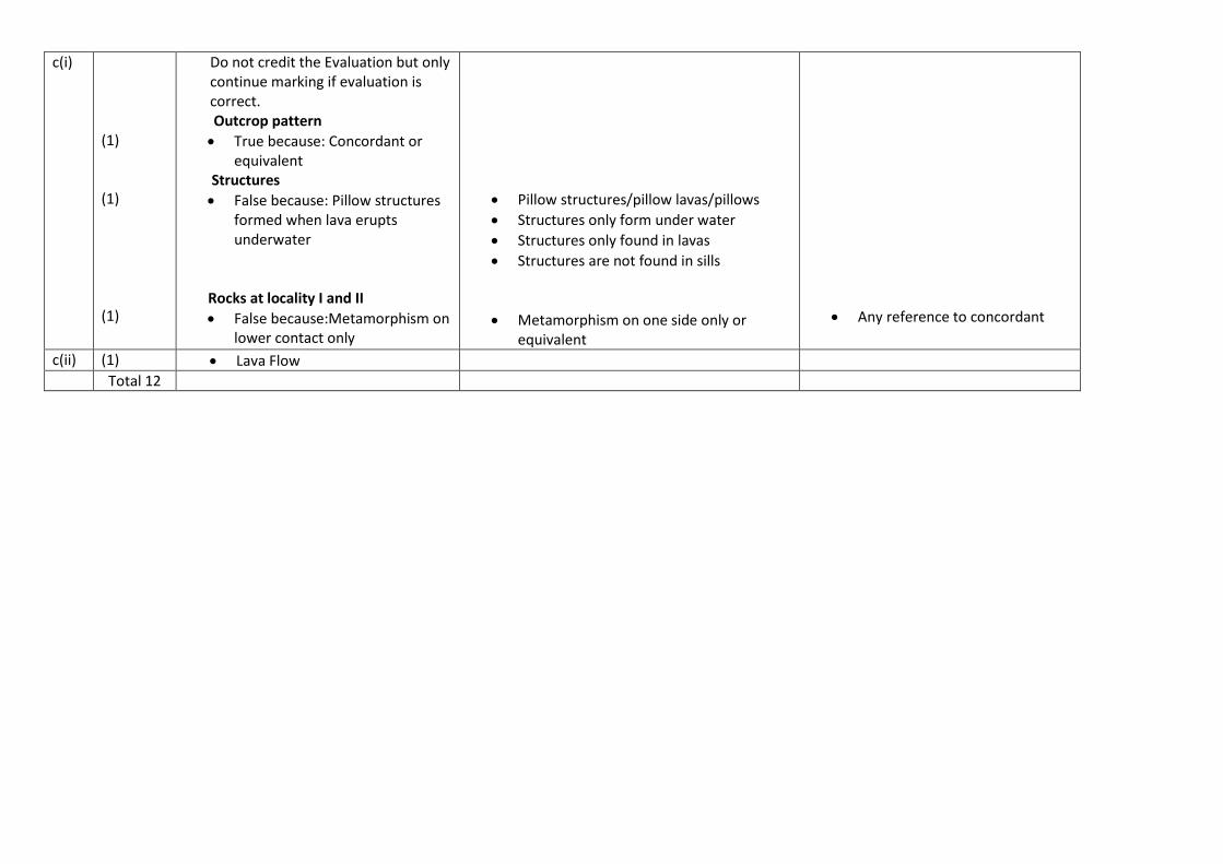
c(i) (1) (1) (1)
Do not credit the Evaluation but only continue marking if evaluation is correct. Outcrop pattern
True because: Concordant or equivalent
Structures
False because: Pillow structures formed when lava erupts underwater
Rocks at locality I and II
False because:Metamorphism on lower contact only
Pillow structures/pillow lavas/pillows
Structures only form under water
Structures only found in lavas
Structures are not found in sills
Metamorphism on one side only or equivalent
Any reference to concordant
c(ii) (1) Lava Flow
Total 12
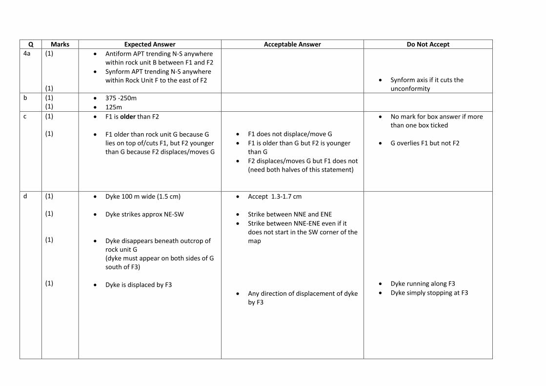
Q Marks Expected Answer Acceptable Answer Do Not Accept
4a (1) (1)
Antiform APT trending N-S anywhere within rock unit B between F1 and F2
Synform APT trending N-S anywhere within Rock Unit F to the east of F2
Synform axis if it cuts the unconformity
b (1) (1)
375 -250m
125m
c (1) (1)
F1 is older than F2
F1 older than rock unit G because G lies on top of/cuts F1, but F2 younger than G because F2 displaces/moves G
F1 does not displace/move G
F1 is older than G but F2 is younger than G
F2 displaces/moves G but F1 does not (need both halves of this statement)
No mark for box answer if more than one box ticked
G overlies F1 but not F2
d (1) (1) (1) (1)
Dyke 100 m wide (1.5 cm)
Dyke strikes approx NE-SW
Dyke disappears beneath outcrop of rock unit G (dyke must appear on both sides of G south of F3)
Dyke is displaced by F3
Accept 1.3-1.7 cm
Strike between NNE and ENE
Strike between NNE-ENE even if it does not start in the SW corner of the map
Any direction of displacement of dyke by F3
Dyke running along F3
Dyke simply stopping at F3

e(i) (1) (1) (1)
Did scratch with a steel pin
Description/observation Credit description of only the following
Heft in hand or equivalent
Look for/at the crystal habit or equivalent Result
Feels heavy or equivalent
Bladed crystals Candidates who have referred to a test/observation other than density or crystal habit will score no mark for description of test/observation, but may score one mark for a correct result of that test or observation for barite as follows
Has 2 good cleavages planes at 90°
Can be scratched by a copper coin
Cannot be scratched by a finger nail
Has a white streak
Has a vitreous (or resinous) lustre
Correct colour for the specimen e.g white, yellow white, pink
Does not react with acid
Tabular crystals
N.B A few samples of specimen H did contain calcite as well as barite. If a candidate has noted a positive acid reaction, then credit this up to two marks for the description of test and result but only if they have then named the mineral as calcite in e(ii)
Has a hardness of 3-3.5 (or any other stated figures alone)
A quoted relative density of 4-5
A quoted hardness value
e(ii) (1) Barite Calcite (but only if positive acid reaction noted in e(i))
Total 14

Q Marks Expected Answer Acceptable Answer Do Not Accept
5
See below
Candidates are asked to complete a sketch cross section not to construct, so the mark scheme allows for some variations in dips/positions of beds
Approximate dip values for fold limbs (40°-60°)
Any dip > 5° on unconformity (base B)
Inclined (<80°)APT of folds
Vertical Fault F1 at an angle of less than 80°
Total 13
[Type a quote from the document or the summary of an
interesting point. You can position the text box anywhere in the
document. Use the Drawing Tools tab to change the formatting
of the pull quote text box.]
NB – There are 14 marks available.
Mark to a maximum of 13.
Q Marks Expected Answer Acceptable Answer Do Not Accept
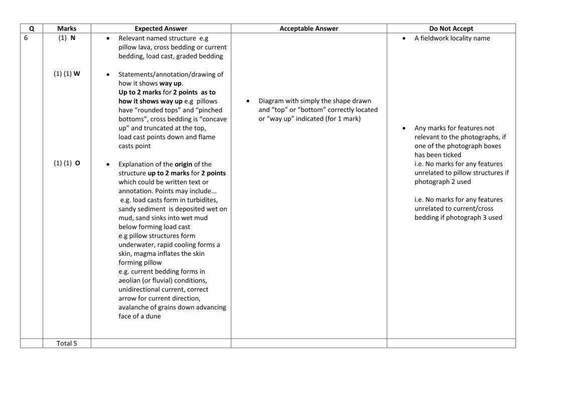
6 (1) N
(1) (1) W
(1) (1) O
Relevant named structure e.g pillow lava, cross bedding or current bedding, load cast, graded bedding
Statements/annotation/drawing of how it shows way up. Up to 2 marks for 2 points as to how it shows way up e.g pillows have “rounded tops” and “pinched bottoms”, cross bedding is “concave up” and truncated at the top, load cast points down and flame casts point
Explanation of the origin of the structure up to 2 marks for 2 points which could be written text or annotation. Points may include... e.g. load casts form in turbidites, sandy sediment is deposited wet on mud, sand sinks into wet mud below forming load cast e.g pillow structures form underwater, rapid cooling forms a skin, magma inflates the skin forming pillow e.g. current bedding forms in aeolian (or fluvial) conditions, unidirectional current, correct arrow for current direction, avalanche of grains down advancing face of a dune
Diagram with simply the shape drawn and “top” or “bottom” correctly located or “way up” indicated (for 1 mark)
A fieldwork locality name
Any marks for features not relevant to the photographs, if one of the photograph boxes has been ticked i.e. No marks for any features unrelated to pillow structures if photograph 2 used i.e. No marks for any features unrelated to current/cross bedding if photograph 3 used
Total 5
© WJEC CBAC Ltd.
GCE Geology – GL3
Summer 2013
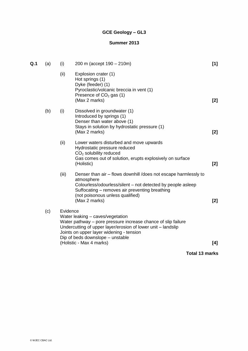
Q.1 (a) (i) 200 m (accept 190 – 210m) [1]
(ii) Explosion crater (1) Hot springs (1) Dyke (feeder) (1)
Pyroclastic/volcanic breccia in vent (1) Presence of CO2 gas (1) (Max 2 marks) [2]
(b) (i) Dissolved in groundwater (1) Introduced by springs (1) Denser than water above (1) Stays in solution by hydrostatic pressure (1) (Max 2 marks) [2]
(ii) Lower waters disturbed and move upwards
Hydrostatic pressure reduced CO2 solubility reduced Gas comes out of solution, erupts explosively on surface (Holistic) [2]
(iii) Denser than air – flows downhill /does not escape harmlessly to atmosphere Colourless/odourless/silent – not detected by people asleep Suffocating – removes air preventing breathing (not poisonous unless qualified) (Max 2 marks) [2]
(c) Evidence Water leaking – caves/vegetation Water pathway – pore pressure increase chance of slip failure Undercutting of upper layer/erosion of lower unit – landslip Joints on upper layer widening - tension Dip of beds downslope – unstable (Holistic - Max 4 marks) [4]
Total 13 marks
© WJEC CBAC Ltd.
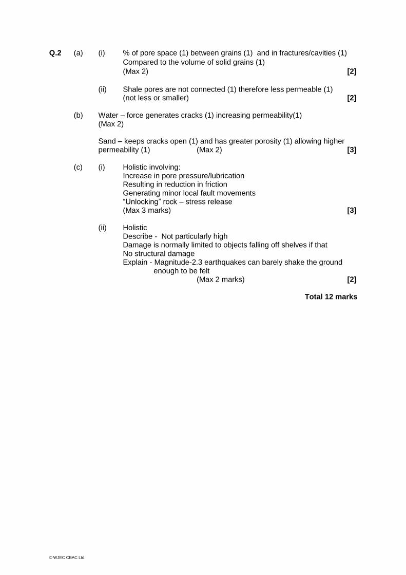
Q.2 (a) (i) % of pore space (1) between grains (1) and in fractures/cavities (1)
Compared to the volume of solid grains (1)
(Max 2) [2]
(ii) Shale pores are not connected (1) therefore less permeable (1) (not less or smaller) [2]
(b) Water – force generates cracks (1) increasing permeability(1) (Max 2) Sand – keeps cracks open (1) and has greater porosity (1) allowing higher permeability (1) (Max 2) [3]
(c) (i) Holistic involving:
Increase in pore pressure/lubrication Resulting in reduction in friction Generating minor local fault movements “Unlocking” rock – stress release (Max 3 marks) [3]
(ii) Holistic Describe - Not particularly high Damage is normally limited to objects falling off shelves if that No structural damage
Explain - Magnitude-2.3 earthquakes can barely shake the ground enough to be felt
(Max 2 marks) [2]
Total 12 marks

© WJEC CBAC Ltd.
Q.3 (a) Outline the social and economic benefits and limitations of attempting to
predict earthquakes.
Benefits: Promotes awareness of potential dangers Protection of life and property reduces hazard Time for disaster planning hazard mapping/landuse planning evacuation procedures emplacement community preparedness preparing the emergency services (fire/ambulance/civil defence) building codes implementation/enforcement contingencies for redevelopment/aid relief Psychological effects - feeling “safe”
Limitations: Prediction does not always allow effective warning (Kobe) Insurance premiums high/house prices fall Hinders economic development Current methods are unreliable LECDs do not have money for prediction or control/favours MEDCs Psychological effects – feeling “unsafe” (Max 10 marks, only advantages or disadvantages max 7) (b) Using one or more case studies, explain how the destructive effects of
earthquakes can be managed and controlled to reduce risk.
Stress release on faults. Theoretical. Release of "locked" areas of fault by injecting fluids along fault to produce smaller controlled earthquakes or underground explosions.
Denver - waste fluids injected into deep wells in fractured rock triggered minor earthquakes until pumping stopped. Water lubricates fault zone.
Colorado - pumping water from deep wells - reduced water pressure/decreased earthquakes.
Both considered as a possible method of releasing the strain in "locked" parts of San Andreas fault. Very expensive and not proven to be safe or feasible yet.
Credit students who write wholly or partly beyond the specification such as:
Evacuation measures (related to prediction), good emergency services and planning, earthquake drills.
Reinforced masonry, reinforced concrete/steel frames. Extra strengthening given to bridges.
Engineered building design - flexible buildings on low slopes. Smart buildings” with counter weight, rubber dampers on foundations etc. Thought given to flexible gas pipe, hoardings and glass in high-rise buildings.
Hazard Maps – prevention of building on land liable to subsidence, liquefaction, flow.
(Max 15 marks, no case study max 12)
Total 25 marks

© WJEC CBAC Ltd.
Q.4 (a) Describe the potential hazards associated with lava flows and explain how the risk to life and property often depends upon the composition of the magma.
Expect: Lava flows Hot 800oC-1000oC, fluid (depending on composition and temp) Can be fast flowing (50km/hr) or slow, travel far (50km) or not Easy to avoid for people/not for property Causes fire and loss of property Can kill in rare cases (very fluid lava) e.g. Nyiragongo (Congo), Etna, etc. Types of magma - mafic/intermediate/silicic Various magmas have different compositions that affect viscosity (more silica rich - more viscous) gas content that affects viscosity (higher gas - more viscous) More viscous silicic magma – explosive as gas is not able to escape easily e.g Pinatubo, Vesuvius, Iceland, Hawaii (Max 10 marks, no case study max 7) (b) Using one or more case studies, explain how the risk to life and property
associated with a major volcanic event largely depends upon the extent to which the eruption can be predicted or its effects minimised.
Holistic approach Minimising volcanic hazards and efficient/effective prediction reduces the risk
and scale of the potential hazard Prediction may include - monitoring ground deformation, gravity and thermal
anomalies, gas emissions and seismic activity (harmonic tremors) Effectiveness discussed and case studies given credit – Pinatubo Minimising may involve - evacuation, hazard mapping, diversion/blocks, dropping/spraying with water, explosion of flow margin Case studies credited – Iceland, Etna Ultimately always risk of hazard if people choose to live near volcanoes (Max 15 marks, no case study max 12)
Total 25 marks

© WJEC CBAC Ltd.
Q.5 (a) Using diagrams, describe how the stability of working faces, associated with the extraction of rock and minerals, may reflect the friction angle and presence of rock disconformities.
Effect of strata dipping "into" and "out of" a rock face (daylighting) at angles <
and > the stable slope friction angle (~35o). Friction angle changes with pore pressure and rock type (shale v sandstone)
Examples Disconformities = Joints/faults/cleavage/bedding. Increased weathering of surface, breaks rock up into discrete sections. Density of joints/faults controls weathering rate. Joint/fault direction patterns. (Max 10 marks, no diagram max 7)
(b) Explain the methods that may be used to monitor potentially unstable slopes. Holistic Ground levelling/surveying Changes in height/position - Rate of change increase Micro seismic monitoring Micro seismic events as rock begins to slide - Increase in number/size/rate Surface strain measurement Changes in the width of surface cracks - Increase in size/rate Electronic distance measurement Laser beam measures distance between fixed points - Changes in distances Tiltmeter Records changes rate of inclination of slope face Borehole distortion meter
Measure tilt/inclination of borehole - Greater distortion from vertical with strain changes
Aerial photographs/satellite imagery - Changes with time Groundwater pressures – Pore pressure changes with time Credit examples Accept volcanic slope monitoring (Mt St Helens) (Max 15 marks)
Total 25 marks
© WJEC CBAC Ltd.
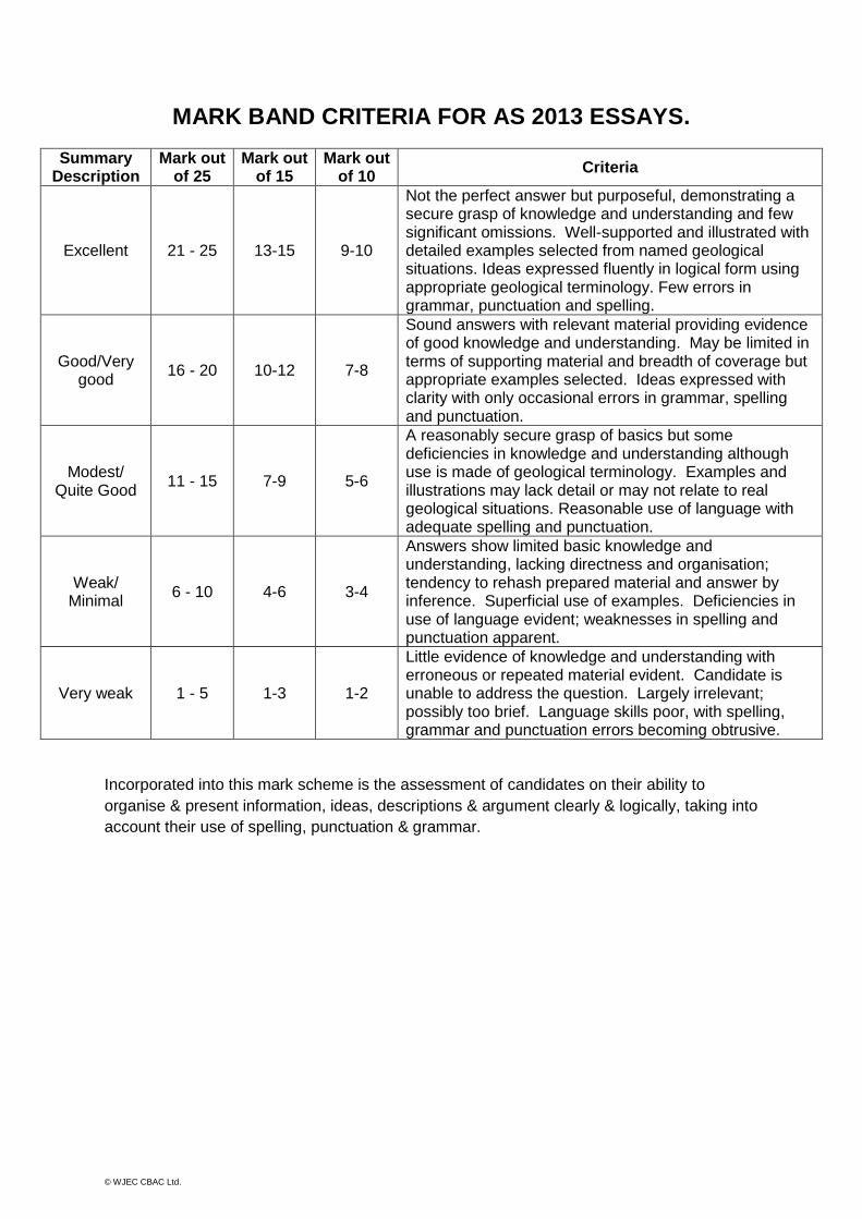
MARK BAND CRITERIA FOR AS 2013 ESSAYS.
Summary Description
Mark out of 25
Mark out of 15
Mark out of 10
Criteria
Excellent 21 - 25 13-15 9-10
Not the perfect answer but purposeful, demonstrating a secure grasp of knowledge and understanding and few significant omissions. Well-supported and illustrated with detailed examples selected from named geological situations. Ideas expressed fluently in logical form using appropriate geological terminology. Few errors in grammar, punctuation and spelling.
Good/Very good
16 - 20 10-12 7-8
Sound answers with relevant material providing evidence of good knowledge and understanding. May be limited in terms of supporting material and breadth of coverage but appropriate examples selected. Ideas expressed with clarity with only occasional errors in grammar, spelling and punctuation.
Modest/ Quite Good
11 - 15 7-9 5-6
A reasonably secure grasp of basics but some deficiencies in knowledge and understanding although use is made of geological terminology. Examples and illustrations may lack detail or may not relate to real geological situations. Reasonable use of language with adequate spelling and punctuation.
Weak/ Minimal
6 - 10 4-6 3-4
Answers show limited basic knowledge and understanding, lacking directness and organisation; tendency to rehash prepared material and answer by inference. Superficial use of examples. Deficiencies in use of language evident; weaknesses in spelling and punctuation apparent.
Very weak 1 - 5 1-3 1-2
Little evidence of knowledge and understanding with erroneous or repeated material evident. Candidate is unable to address the question. Largely irrelevant; possibly too brief. Language skills poor, with spelling, grammar and punctuation errors becoming obtrusive.
Incorporated into this mark scheme is the assessment of candidates on their ability to
organise & present information, ideas, descriptions & argument clearly & logically, taking into
account their use of spelling, punctuation & grammar.
© WJEC CBAC Ltd.
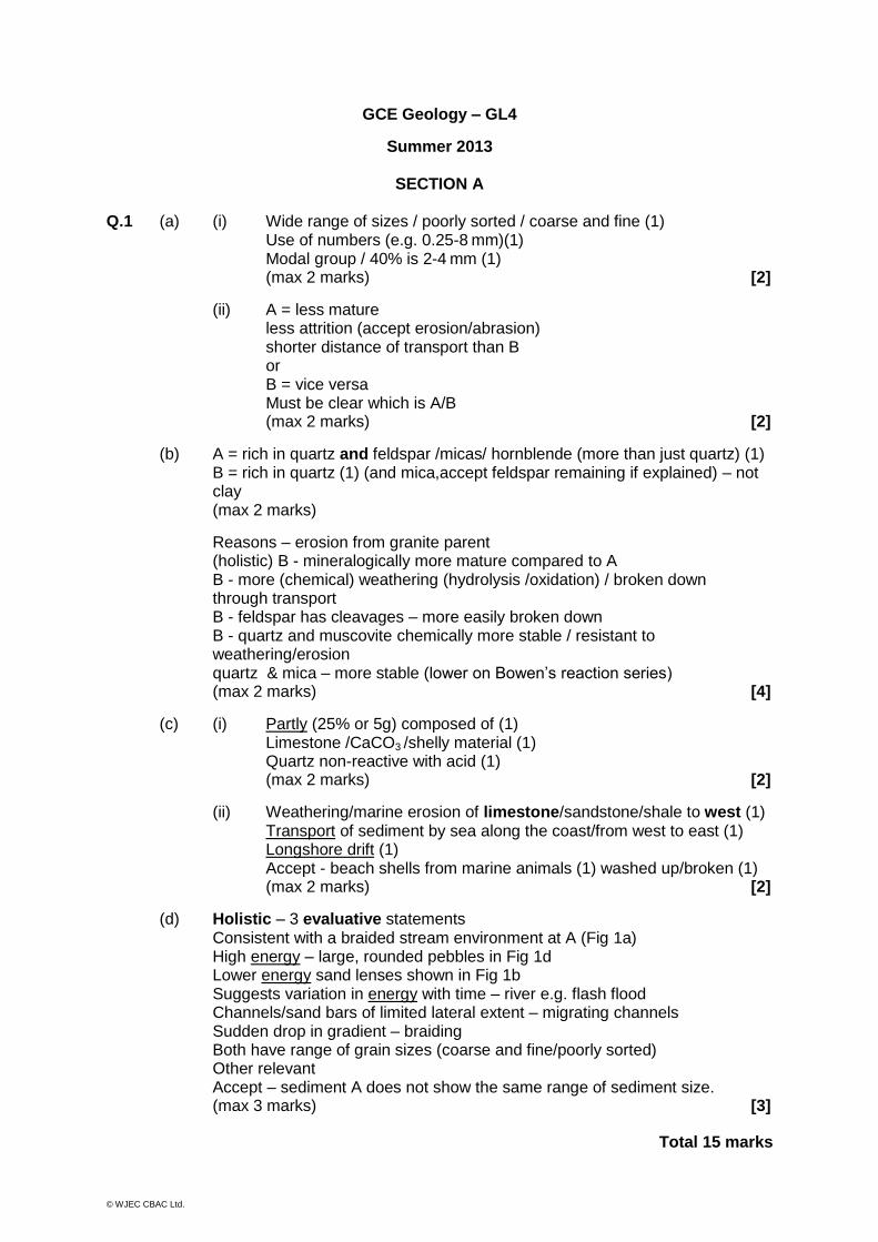
GCE Geology – GL4
Summer 2013
SECTION A
Q.1 (a) (i) Wide range of sizes / poorly sorted / coarse and fine (1) Use of numbers (e.g. 0.25-8 mm)(1) Modal group / 40% is 2-4 mm (1) (max 2 marks) [2]
(ii) A = less mature less attrition (accept erosion/abrasion) shorter distance of transport than B
or B = vice versa Must be clear which is A/B (max 2 marks) [2]
(b) A = rich in quartz and feldspar /micas/ hornblende (more than just quartz) (1) B = rich in quartz (1) (and mica,accept feldspar remaining if explained) – not clay (max 2 marks)
Reasons – erosion from granite parent (holistic) B - mineralogically more mature compared to A B - more (chemical) weathering (hydrolysis /oxidation) / broken down through transport B - feldspar has cleavages – more easily broken down B - quartz and muscovite chemically more stable / resistant to weathering/erosion quartz & mica – more stable (lower on Bowen’s reaction series) (max 2 marks) [4]
(c) (i) Partly (25% or 5g) composed of (1) Limestone /CaCO3 /shelly material (1) Quartz non-reactive with acid (1) (max 2 marks) [2]
(ii) Weathering/marine erosion of limestone/sandstone/shale to west (1) Transport of sediment by sea along the coast/from west to east (1) Longshore drift (1) Accept - beach shells from marine animals (1) washed up/broken (1) (max 2 marks) [2]
(d) Holistic – 3 evaluative statements Consistent with a braided stream environment at A (Fig 1a) High energy – large, rounded pebbles in Fig 1d Lower energy sand lenses shown in Fig 1b Suggests variation in energy with time – river e.g. flash flood Channels/sand bars of limited lateral extent – migrating channels Sudden drop in gradient – braiding Both have range of grain sizes (coarse and fine/poorly sorted) Other relevant Accept – sediment A does not show the same range of sediment size. (max 3 marks) [3]
Total 15 marks
© WJEC CBAC Ltd.
Q.2 (a)
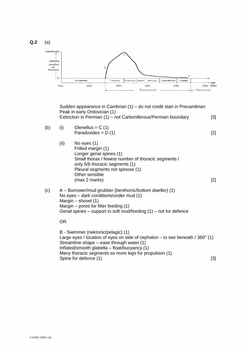
Sudden appearance in Cambrian (1) – do not credit start in Precambrian Peak in early Ordovician (1) Extinction in Permian (1) – not Carboniferous/Permian boundary [3]
(b) (i) Olenellus = C (1) Paradoxides = D (1) [2] (ii) No eyes (1)
Frilled margin (1) Longer genal spines (1) Small thorax / fewest number of thoracic segments / only 5/6 thoracic segments (1) Pleural segments not spinose (1) Other sensible (max 2 marks) [2]
(c) A – Burrower/mud grubber (benthonic/bottom dweller) (1) No eyes – dark conditions/under mud (1) Margin – shovel (1) Margin – pores for filter feeding (1) Genal spines – support in soft mud/feeding (1) – not for defence
OR
B - Swimmer (nektonic/pelagic) (1) Large eyes / location of eyes on side of cephalon – to see beneath / 360° (1) Streamline shape – ease through water (1) Inflated/smooth glabella – float/buoyancy (1) Many thoracic segments so more legs for propulsion (1) Spine for defence (1) [3]
© WJEC CBAC Ltd.
(d) (i) Holistic mineralised skeletons only evolved at the Cambrian fossil record is biased previously they were soft bodied / lacking hard parts did not survive preservation before Cambrian(max 2) [2]
(ii) Arrow (E) at ~565Ma (635-542 Ma) [1] (iii) Snowball Earth finishes (1) New opportunities for evolutionary development (1)
e.g. environment changed / warmed, more favourable for life; nutrients in the sea, organisms expand into niches; volcanoes give out CO2, could be used in creating hard parts / CaCO3 Or alternative theory (max 2 marks) [2]
Total 15 marks

© WJEC CBAC Ltd.
Q.3 (a) (i) Lower below boundary/decreases above boundary/increases and reaches maximum (1) Dramatic increase at KT boundary Use of numbers (1) (max 2 marks) [2]
(ii) Excellent / very good / strong (1) Positive correlation / both peak at KT boundary / as iridium increases so does soot (or vice versa) (1) Use of numbers (1) Tertiary less good correlation, iridium decreases but soot fluctuates (1) (max 2 marks) [2]
(iii) Asteroid / impact (related to iridium) (1)
Heat from impact caused wildfires creating soot (1R) which correlates with impact debris/iridium falling from suspension (1) (max 2 marks – R plus 1) [2]
(b) (i) Spherical – condense in a droplet (around initial nucleus) drop through atmosphere rotating as they fall (max 1 mark) Glassy - rapid cooling of melt (1) [2] (ii) Holistic – evidence explained
Additional spherule layers (1) – further impacts (long geological time) of earlier Chicxulub (1) Micro-tektites/spherules show erosion (1) takes a long time (1) Limestone deposited between spherule layers (1) take a long time to be deposited (1) Sandstone burrowed - long time in deposition to form (1) Chicxulub layer is over 8m (1) down/below/underneath so long time between (1) Other sensible credited (2 plus 2 = max 4 marks) [4]
(c) One of: Volcanic activity – Deccan (1) flood basalt (1) / environmental impact/change e.g. SO2, ash blocks out sun (1) Changes in sea-level – loss of habitat – greater competition Rapid climate change – unable to adapt/loss of food/methane hydrate release Other appropriate and explained
(max 3 marks) [3]
Total 15 marks
© WJEC CBAC Ltd.
Q.4 (a) (i) Outcrop – must include xenoliths [1] (ii) Dyke continued to Quarry A (1) Cross-cutting pluton (1) [2] (b) (i) Direction of σ max – N-S (1R) do not accept only ‘north’ or ‘south’ Evidence E-W orientation of slaty cleavage / slate dips / faces south (1) aligned at 90 degrees to stress (1) axial planar cleavage seen at 90° to the relict bedding (folds / axial planes) (1) (max 3 marks – R plus 2) [3] (ii) Forcible intrusion of granite (1) locally (radial) distortion of the cleavage (1) [2] (c) Holistic
C recrystallised following the (original) regional metamorphism / contact metamorphism (high temperature / low pressure) (1) C shows random growth of new mineral – spotted rock/hornfels/chiastolite That cut across the original foliation It is in the metamorphic aureole of the pluton/close to the pluton (max 3 marks) [3]
(d) (i) Na-rich on rim rising to Ca-rich in core [1] (ii) Holistic
Ca-rich first to crystallise Solid solution series Temp drops too fast for equilibrium to be maintained Crystals unable to completely react back with melt/equilibrium Before more Na-rich crystals form around older crystals Process continues until crystallisation complete (max 3 marks) [3]
Total 15 marks
© WJEC CBAC Ltd.
SECTION B
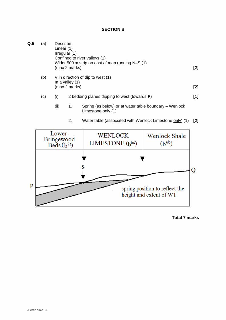
Q.5 (a) Describe Linear (1) Irregular (1) Confined to river valleys (1) Wider 500 m strip on east of map running N–S (1) (max 2 marks) [2] (b) V in direction of dip to west (1) In a valley (1) (max 2 marks) [2] (c) (i) 2 bedding planes dipping to west (towards P) [1] (ii) 1. Spring (as below) or at water table boundary – Wenlock Limestone only (1) 2. Water table (associated with Wenlock Limestone only) (1) [2]
Total 7 marks
© WJEC CBAC Ltd.
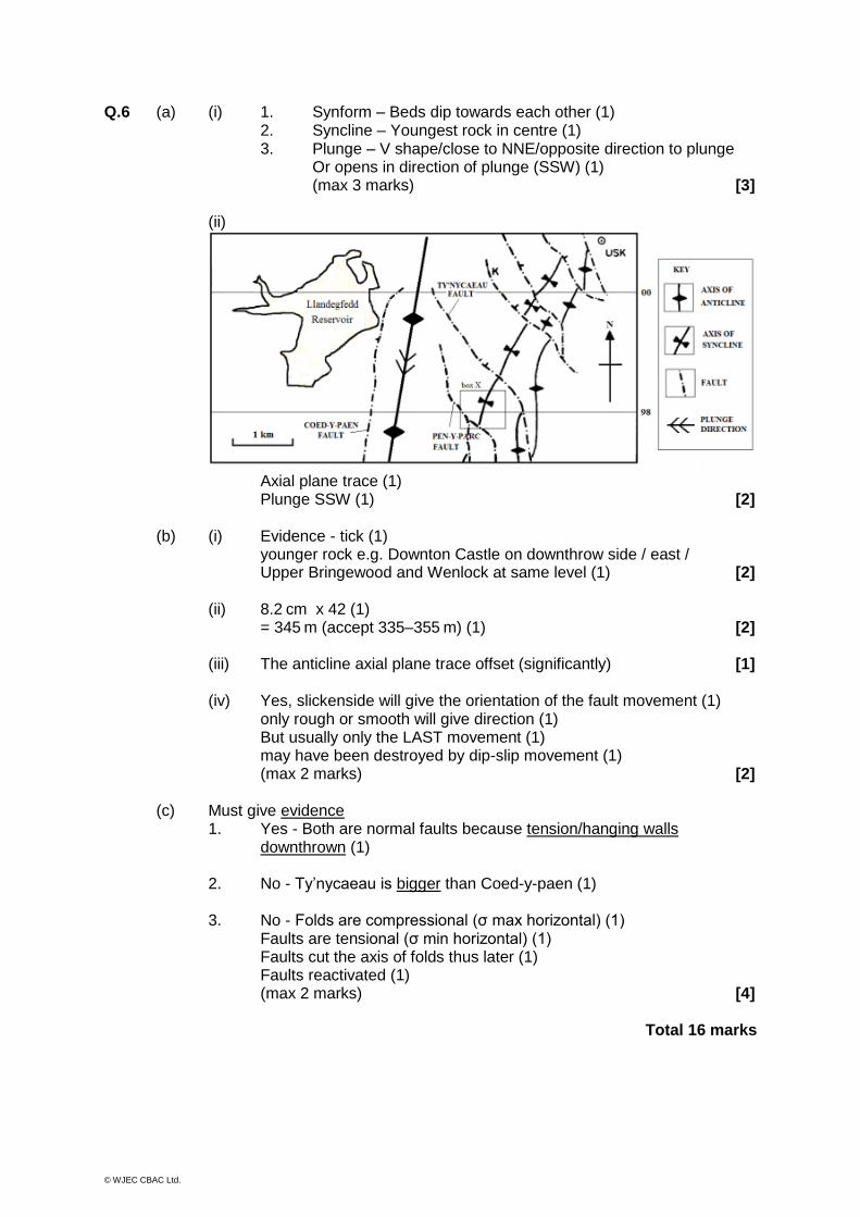
Q.6 (a) (i) 1. Synform – Beds dip towards each other (1) 2. Syncline – Youngest rock in centre (1) 3. Plunge – V shape/close to NNE/opposite direction to plunge Or opens in direction of plunge (SSW) (1) (max 3 marks) [3] (ii)
Axial plane trace (1) Plunge SSW (1) [2] (b) (i) Evidence - tick (1)
younger rock e.g. Downton Castle on downthrow side / east / Upper Bringewood and Wenlock at same level (1) [2]
(ii) 8.2 cm x 42 (1) = 345 m (accept 335–355 m) (1) [2] (iii) The anticline axial plane trace offset (significantly) [1] (iv) Yes, slickenside will give the orientation of the fault movement (1)
only rough or smooth will give direction (1) But usually only the LAST movement (1) may have been destroyed by dip-slip movement (1) (max 2 marks) [2]
(c) Must give evidence 1. Yes - Both are normal faults because tension/hanging walls downthrown (1)
2. No - Ty’nycaeau is bigger than Coed-y-paen (1) 3. No - Folds are compressional (σ max horizontal) (1)
Faults are tensional (σ min horizontal) (1) Faults cut the axis of folds thus later (1) Faults reactivated (1) (max 2 marks) [4]
Total 16 marks
© WJEC CBAC Ltd.
Q.7 (a) Height = 200 cm (accept 150–250 cm) (1) Direction = E (1) [2] (b) Any two features for (1) each Dip 10° Massive (limestone) Irregular bedding planes Joints / fractures Erosion surface More weathered/less weathered Other sensible e.g. biological weathering No credit for ‘rusty colour’, unconformity, cleavage planes [2] (c) Holistic
Suitable: Limestone is jointed = permeable Underlain and overlain by impermeable siltstones and
mudstones = water (artesian) trapped Synformal structure between faults – basin to trap water Outcrop on surface Not much faulting – stable
Less suitable: Limestone relatively thin – 10 m Limited surface outcrop Antiformal structures - water will flow away down dip Faulting in area (max 3 marks) [3]
Total 7 marks

© WJEC CBAC Ltd.
Q.8 (a) 1. Dip (limited factor) (1) Angle too shallow/gentle/10° or less – below stable friction angle (1)
Direction – against the dip to SW into the hill (– not significant) (1) Credit lubrication / pore water pressure (max 2 marks)
2. Fluvial conditions (possible factor) (1)
River undercutting the toe of slide (1) Change to hydrological system (limestone filling up with water, lubricating/reducing friction) (1)
(max 2 marks)
3. Faulting (possible factor) Reactivation/movement/activated/dynamic movement- weakness – water channel
(max 1 mark) [5] (b) (i) Holistic
Siltstones and mudstones (b7a Lower Bringewood beds) base (1) Impermeable – less leakage (1) River valley bottom – catchment (1) Spring line evidence (1) Stable, no faults cut the site (1) (max 2 marks) [2]
(ii) Following explained Landslide – further slip / unstable ground (1) Permeable limestones (b6c Wenlock Limestone) – leakage (1) Faulting – reactivation/ leakage (1) Other sensible e.g. weight of dam on rocks (1) (max 3 marks) [3]
Total 10 marks
© WJEC CBAC Ltd.
GCE GEOLOGY
SUMMER 2013 MARK SCHEME
Theme 1 – Quaternary Geology
Q.1 (a) (i) Scotland granite fragments (1)
calcareous mud and marine shell fragments from sea bed (1) [2]
(ii) e.g. glacial striations (1)
scratches on bedrock made as a result of erosion by fragments held in
the ice (1) trending NE-SW (1)
allow other evidence 2 max [2]
(b) (i) alignment - flow/solifluction flow (1)
local debris not transported far (1)
ice wedge casts, origin (2) [2]
(ii) poorly sorted - dumped by ice (1)
angular - little attrition during transport by ice (1)
matrix of rock flour ground by ice (1)
no bedding - dumped by ice (1) 3 max [3]
(c) (i) raised beach/wave-cut platform above sea level
accept conglomerate above sea level [1]
(ii) drowned river/ria and /or submerged forest
explained [2]
(d) interglacial/temperate raised beach/conglomerate and platform
periglacial cooling climate lower head
ice advance/glaciation till
periglacial warming climate upper head
interglacial/temperate ria/submerged forest
5 correct (3) 3/4 correct (2) 1/2 correct (1)
[3]
Total 15 marks
© WJEC CBAC Ltd.
Q.2 (a) Draw a sketch section across a modern carbonate reef system. Describe the
variation in grain type, grain size and texture of limestones that may be found
in this environment.
(b) Evaluate the extent to which biological, physical and chemical processes
contribute to the formation of the types of limestone shown in the sketch
section.
(a) Description
grain type – peloids, ooliths, bioclasts, microfossils, macrofossils, reef
fragments, calcite mud
grain size – coarse to fine
textures – oolitic, bioclastic, pelitic, micrite, sparite, coarse fragments
OR
description of rock types such as oosparite, biosparite, micritic mudstone,
breccias (reef debris)
(b) Evaluate role of processes such as currents (oolitic), biological (reef), storm
waves (reef debris), chemical (precipitation of calcite mud)
Total 25 marks
© WJEC CBAC Ltd.
Q.3 (a) Describe how an analysis of (i) pollen diagrams and
(ii) the vertebrate record
can provide evidence for climatic fluctuations in Britain during the Quaternary.
(b) Evaluate the use of radiocarbon dating (14C) of organic material from the
Quaternary.
(a) Description
(i) pollen – dispersal of pollen from living vegetation, death assemblage
in lake sediments not same as original vegetation proportions due to
differing amounts from each plant/types of pollination
ease of preservation
analysis of sediment, reconstruction of assemblage may be biased to
certain species,
interpretation based on modern floral distributions related to climatic
zones
use of herbs/grasses, lack of tree pollen (tundra) coniferous forest,
deciduous forest in determining climate
(ii) vertebrates – disarticulated skeletons, incomplete terrestrial record,
lack of abundance, special preservation
uniformitarianism, similar modern species, similar adaptations,
adapted to climate (temperature)
or distribution of food source
http://www.chobham.info/images/Glacial_Animals.gif
(b) Evaluate
only date organic material; half-life of 5,730 years so can only date recent
events (100,000 y?)
cannot be used for most of the Quaternary
problems with contamination e.g. pollen
can be useful for marine record but terrestrial record of fossils incomplete and
discontinuous
Total 25 marks
© WJEC CBAC Ltd.
Q.4 (a) Using illustrated examples, explain the relationship between geology and
topography in three of the following:
dipping strata
folds
faults
joints
igneous bodies
(b) Evaluate the view that Quaternary landforms are only partly controlled by
geological structure and lithology.
(a) Description of three examples
Case studies might include:
Wenlock Edge (dipping strata), Pennines / Weald (folds),
Great Glen / Craven fault (faults), Arthur’s Seat / Skye (igneous),
Giant’s Causeway (igneous / joints)
Look for quality diagrams, labelling, authentic examples and relationship to
geology
(b) Evaluate influence of glacial/periglacial deposits and glacial erosion on
landforms which mask/add to underlying geology
Total 25 marks

© WJEC CBAC Ltd.
Theme 2 – Geology of Natural Resources
Q.1 (a) (i) >100m wide at top, 20-30m wide at bottom (1)
elongated (1) vertical/very steeply dipping (1) thin (1) tapering down (1)
[(1) for size + (1) for description of shape]
2 max [2]
(ii) massive sulphide (1) + (hydrothermal) veins (1)
in association with volcanic rock (1) parallel to boundaries of lava (1)
at a destructive plate margin (1) black smokers (1)
3 max [3]
(b) (i) covered by glacial till (1) no exposure at surface (1)
till impermeable so no geochemical trace (1)
other acceptable reason (1) 2 max [2]
(ii) gravity survey (1) gravimeter (1) measures changes in density (1)
ore mineral denser than surrounding rocks (1) done on land or in the
air (1)
magnetic survey (1) measures changes in magnetic field (1)
ore minerals mostly have some iron content (1) done on land or in the
air (1)
seismic survey (1) explosions/vibrations (1)
reflect seismic waves off ore body (1)
denser than surrounding rocks (1) record 2-way travel time (1)
electrical survey (1) current passed through the ground (1)
measure conductivity / resistivity of rocks (1) less effective because of
impermeable cover (1)
only credit 1 technique 4 max [4]
(c) (i) waste tips at surface (1) acid mine drainage (1)
heavy metal contamination (1) visual impact of mine (1)
interference with groundwater flow (1)
stability of rock faces (1) noise/vibration from blasting (1) – any one
[1]
(ii) answer depends on problem chosen e.g. restricted blasting, bunding,
settling tanks, treatment of water, backfill, vegetation,
liners / geomembranes
holistic mark [3]
Total 15 marks

© WJEC CBAC Ltd.
Q.2 Evaluate the statement:
“Sedimentary processes and associations can produce metalliferous ores and
non-metallic minerals of economic importance.”
Metalliferous ores: reference to placer deposits (e.g. gold),
residual deposits (e.g. bauxite) and precipitated deposits (e.g. lithium),
weathering (e.g. Malachite & Azurite)
Processes concentrating metals into economically viable deposits
Non-metalliferous minerals (deposits): reference to china clay, limestone, diamond
sands, bulk sand and gravel etc. [could refer to coal]
Credit examples given and discussion of processes
Breadth v depth
Must evaluate the role sedimentary processes play for full marks
Total 25 marks
Q.3 (a) Describe how coal-forming environments can produce coal of different ranks.
(b) Evaluate the use of depleted oil and gas reservoirs as possible CO2
repositories (carbon sequestration).
(a) Description of coal-forming swamps/deltas
Supply of organic material exceeds rate of decay
Rapid burial of organic material/removal from aerobic conditions
Subsidence of sequence of rocks
Temperature and duration of burial
Expulsion of volatiles/increase in % of carbon
Progression from peat-lignite-bituminous coal-anthractite
Credit diagrams and examples
(b) Possible solution to climate change
Carbon capture and storage, CO2 is removed from flue gases, such as in
power stations and oil refineries, before being stored in underground
reservoirs. Can reduce emissions by 80-90%.
Hydrocarbon traps provide a location to permanently store carbon dioxide in
the rocks.
Energy cost - uses 10-40 % of the energy produced by a power station.
Wide adoption of CCS may negate efficiency gains of the last 50 years.
No effect on emissions from transport & extraction of fuel
Expensive solution to problem
Must evaluate for full marks
Total 25 marks

© WJEC CBAC Ltd.
Q.4. Evaluate the role of geological factors in controlling the formation, migration and
accumulation of oil and natural gas.
Planktonic life in surface waters of oceans (oil & gas)
Land plants (gas)
Source rock – clay/shale with high organic content
Depth: temperature and duration of burial
Porosity and permeability of rock
Pathways of migration: faults, joints, bedding surfaces, pore spaces
Reservoir rock
Cap rock: impermeable clay/shale
Structures to create traps: anticline, fault, unconformity, salt domes
All factors must occur in correct sequence for economic accumulations of
hydrocarbons
Credit diagrams and examples
Must evaluate for access to full marks
Total 25 marks
© WJEC CBAC Ltd.
Theme 3 – Geological Evolution of Great Britain
Q.1 (a) L: graptolite (1)
M: trilobite (1) [2]
(b) (i) any 2 from
irregular / folded / discontinuous (disjointed / chaotic etc) for (1) each
2 max [2]
(ii) current-bedded / undisturbed beds below (and above) /
no metamorphism [1]
(c) (i) (assemblage or) corals / brachiopods / trilobites (1)
one explained (1) [2]
(ii) flute casts ? / shales ? / (grading?) / no fossils (1)
explained (1) [2]
(iii) slump structures (1) explained (1) [2]
(d) corals and brachiopods / Law of Uniformitarianism = warm climate
no evidence of latitude change / require pattern or palaeomagnetism
sound conclusion [4]
Total 15 marks
© WJEC CBAC Ltd.
Q.2. Geological evidence suggests that Britain drifted northwards throughout the
Carboniferous and Permo-Triassic.
Describe and evaluate the evidence provided by
(i) sedimentary rocks and fossils,
(ii) palaeomagnetism.
Description – up to 19 marks
(i) Carboniferous equatorial carbonate platform
Bioclastic and oolitic limestones re Law of Uniformitarianism
Colonial corals / reefs
Brachiopods
Coal / seatearth / abundant vegetation / tropical forest / swamp
Cross-bedded deltaic sandstones
Abundant plant fossils - ferns, tree ferns
Insects / amphibians
Permian desert
Red sandstones / haematite / iron oxide staining / well sorted, rounded
/ aeolian dune bedding / evaporites / breccias / desiccation cracks
Rare fossils / tracks / trails / footprints
(ii) Palaeomagnetism, low angle inclination explained
Evaluation – 20+ marks
(i) Open to interpretation, overall trend plus Law of Uniformitarianism offers
convincing evidence
(ii) Reliable data will give low angle magnetic inclination, decreasing to zero and
then to a low angle again, possibly more convincing than (i)?
Assumes dipolar field
Assumes rocks undisturbed / tectonic / metamorphism
Inaccuracies in dating methods
Total 25 marks
© WJEC CBAC Ltd.
Q.3 (a) Describe the range of igneous bodies and their associated rock types found in
the Tertiary Igneous Province.
(b) Evaluate the importance of this range to an understanding of the plate
tectonic setting in which it was produced.
(a) Description – up to 19 marks
Abundant igneous activity in NW Britain. Locations.
Range of bodies. Flood basalts. Plutons - granitic and gabbroic.
Dyke swarms.
Sills. Columnar jointing.
Range of rock types. Basaltic volcanic activity and associated gabbroic and
granitic centres.
(b) Evaluation – 20+ marks
Mantle plume develops beneath northwest UK and Greenland.
Rifting and development of spreading centre, opening of North Atlantic.
Large volume of (flood) basalt associated with mantle plumes.
Hot spot trail to Iceland. Mid ocean ridge still active.
Evidence of tension (dykes etc.)
Later granitic intrusions due to melting of continental crust.
Total 25 marks
Q.4. Describe and evaluate the use of igneous and metamorphic rocks and structures in
interpreting the plate tectonic setting in which the Caledonian Orogeny developed.
Description – up to 19 marks
Granite intrusions in Scotland and Lake District, less so in Wales.
Andesites, tuffs etc. in Lake District, Rhyolites etc. in Wales
High grade regional metamorphism in Scotland (gneiss, migmatites), lower grade in
Lake District and Wales (slates)
Evaluation – 20+ marks
Granites suggest deep crustal melting
Metamorphism suggests heat/ pressure at depth in continental crust
Continent/continent convergence (NE-SW trend suggest plates converging
from SE and NW)
Total 25 marks
© WJEC CBAC Ltd.
Theme 4 – Geology of the Lithosphere
Q.1 (a) station 2: 30 s (accept 28-32) (1)
station 11: 77 s (accept 74-78) (1) [2]
(b) drawn correctly starting at source with i = r (accept multiple reflections) [2]
(c) velocity increases as P waves enter more rigid medium / mantle 6.5 to 8.1 kms-1 refraction (occurs / away from the normal)
reverse occurs as P wave refracts to station (3 valid points) [3]
(d) (i) 260 ±10% [1]
(ii) use the candidate’s answer to (d)(i)
correct use of velocities 8.1 and 6.5 (1)
correct substitution = √(1.4/14.6) or √0.11 (1)
answer should be = 260/2 x 0.33 = 43 (1) [3]
(e) holistic 3 marks for description / explanation
A – weathered and eroded / craton / expect “average” 30-35km /
40km above average
B – ocean basins / thin oceanic crust/ expect 5-10km
C – orogenic belt / collision / crustal thickening / above average
D – collision / subduction / thickening / above average / not to 40km
[4]
Total 15 marks
© WJEC CBAC Ltd.
Q.2 (a) Describe the range of tectonic structures caused by brittle deformation.
(b) Evaluate the role of tensional stresses in their formation in orogenic belts.
(a) Descriptions – up to 19 marks
Faulting - normal, reverse and tear, credit labelled diagrams
(b) Evaluation – 20+ marks
Forces (principal stresses) produce folding (ductile) and/or faulting (brittle)
Orogenesis mainly compressional / thrusts
Tension produces normal faults / rifts, more common at CPM
Relationship between stress orientation and type of deformation,
stress / strain curves
Elastic limit, faulting before elastic limit, effect of temperature
Depth v breadth
Total 25 marks
Q.3 (a) Describe the nature and origin of the layered structure of the oceanic
lithosphere.
(b) Evaluate the contribution that ocean drilling has made to our understanding of
the layered structure and composition of the oceanic lithosphere.
(a) Descriptions – up to 19 marks
Layers 1, 2 and 3, credit labelled diagrams
MOR, sediment (oozes), pillow, dyke, plutonic form, sea floor spreading
Convection, thickening of sediments (+crust) away from ridge
(b) Evaluation – 20+ marks
Confined to upper layers, sediment and pillows easy by dredging, drilling very
superficial
Modern technology beginning to make possible but as yet very limited and
best “direct” evidence from ophiolites
Total 25 marks
© WJEC CBAC Ltd.
Q.4 (a) Describe the distribution of ages of rocks in continental areas.
(b) Evaluate the link between this age distribution and the J Tuzo Wilson cycle.
(a) Descriptions – up to 19 marks
Example(s), older rock surrounded by or adjacent to younger rocks
Africa and North America provide examples, Britain older to NW and younger
to the SE
(b) Evaluation – 20+ marks
Continents “grow” due to abduction at DPM, younger material is obducted
onto older material
Destructive plate margins, essentially older material in the centre /
progressively younger outwards (e.g. North America)
Obduction may not be from all sides and continents may be split due to plate
tectonics (e.g. Britain.)
This may be explained by the J Tuzo Wilson Cycle re. break up of
(super)continents in stages leading to formation of (super)continents
Total 25 marks

© WJEC CBAC Ltd.
MARK BAND CRITERIA FOR A2 ESSAYS
Summary Description
Marks out of 25
Criteria
Outstanding 25-23 Not the perfect answer, but a candidate could not be expected to produce better work at this level in the time allowed.
Very good 22-20 Arguments are purposeful, well supported & show both balance and style. Irrefutable evidence of a thorough grasp of concepts & principles. A hint of flair apparent in work.
Good 19-17 The answer is direct & explicit; shows the ability to use knowledge & understanding & to discuss. May be limited in terms of supporting material & breadth of coverage.
Quite good 16-14 Shows a reasonably secure grasp of the basics, but answer may show some slight deficiencies in terms of either knowledge & understanding or directness & organisation.
Modest 13-11 Material is mainly relevant & sound, but points need more development (& support). Could be much more direct & explicit in approach.
Minimal 10-8 Work impoverished by limited knowledge & understanding; tendency to rehash prepared material & to answer by inference. Answer rather hit & miss.
Weak 7-5 Little evidence of knowledge or understanding; unable or unwilling to address the question; essentially random in approach.
Very weak 4-1 Largely irrelevant; too brief; abundant erroneous material.
Unacceptable 0 Wholly irrelevant or nothing written.
Incorporated into this mark scheme is the assessment of candidates on their ability to organise & present information, ideas, descriptions & argument clearly & logically, taking into account their use of spelling, punctuation & grammar.

© WJEC CBAC Ltd.
QUICK GUIDE
Description K / U Discussion Terminology
Outstanding 23-25 Not perfect BUT Thorough
Very good 20-22 Thorough grasp Well supported. Hint of flair + EVALUATION
Sound
Good 17-19 Direct/explicit Limited support - breadth. Lacks detail - depth
Significant
Quite Good 14-16 Basics Slight deficiencies. Limited scope relevance
Basic
Modest 11-13 Mainly relevant Needs much more development
Minimal 8-10 Limited/rehash Hit and miss Little
Weak 5-7 Little evidence Question not addressed
Very Weak 1-4 Irrelevant/erroneous Too brief
Unacceptable
0
Thus key dividing lines are:
Outstanding - Across the board – no significant weaknesses
Very good - EVALUATION
Good - Good read - some omissions in content/detail/discussion
Quite Good - Essay title has been addressed but not a convincing argument
Modest - Bit difficult to follow. Do they really know? Addressed the question but need much more discussion = mark scheme
Minimal/Weak/Very Weak - Rehash at best - irrelevant material/no essay to mark/mark per point?
GCE GEOLOGY MS without unit 2a - Summer 2013

© WJEC CBAC Ltd.
WJEC 245 Western Avenue Cardiff CF5 2YX Tel No 029 2026 5000 Fax 029 2057 5994 E-mail: [email protected] website: www.wjec.co.uk