Embed Size (px)
Citation preview
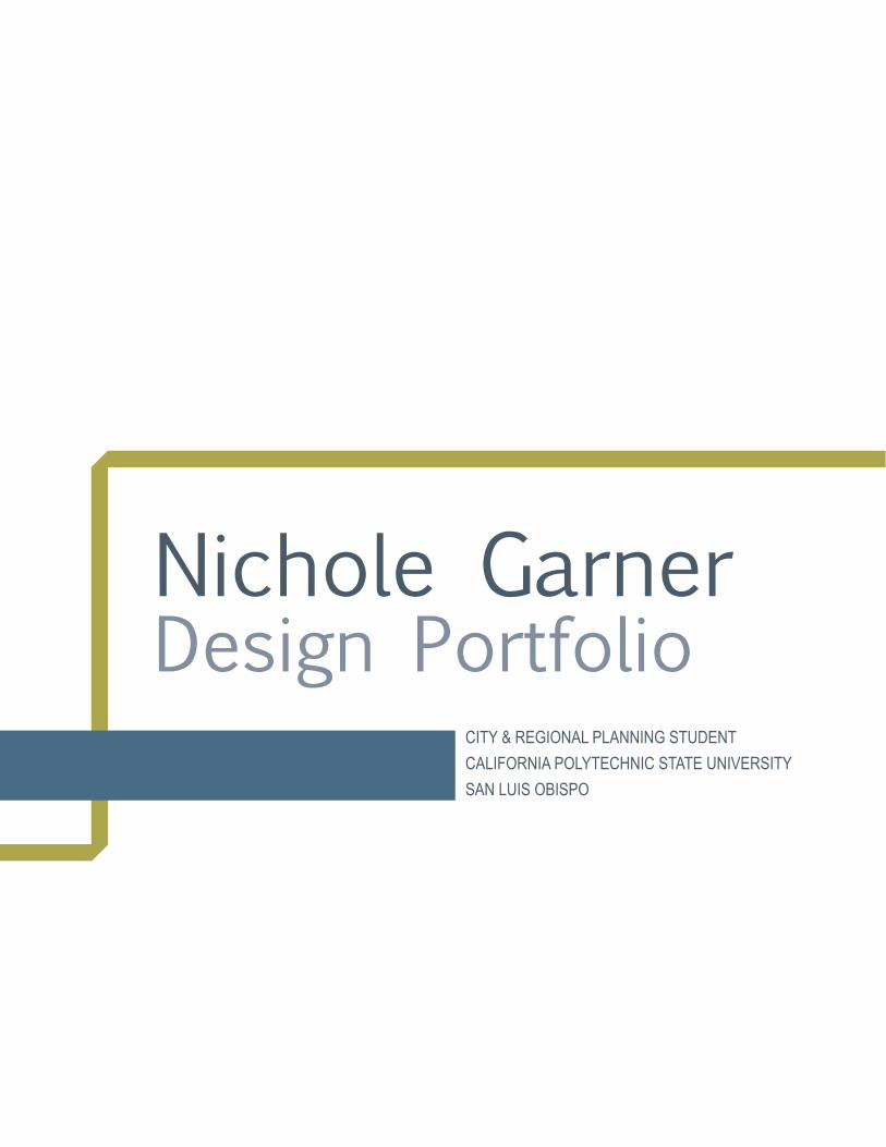
Nichole GarnerDesign Portfolio
CITY & REGIONAL PLANNING STUDENTCALIFORNIA POLYTECHNIC STATE UNIVERSITYSAN LUIS OBISPO

CONTENTS
Studio Project 1................................................................4Studio Project 2................................................................6Studio Project 3................................................................8
4 Garner | Portfolio
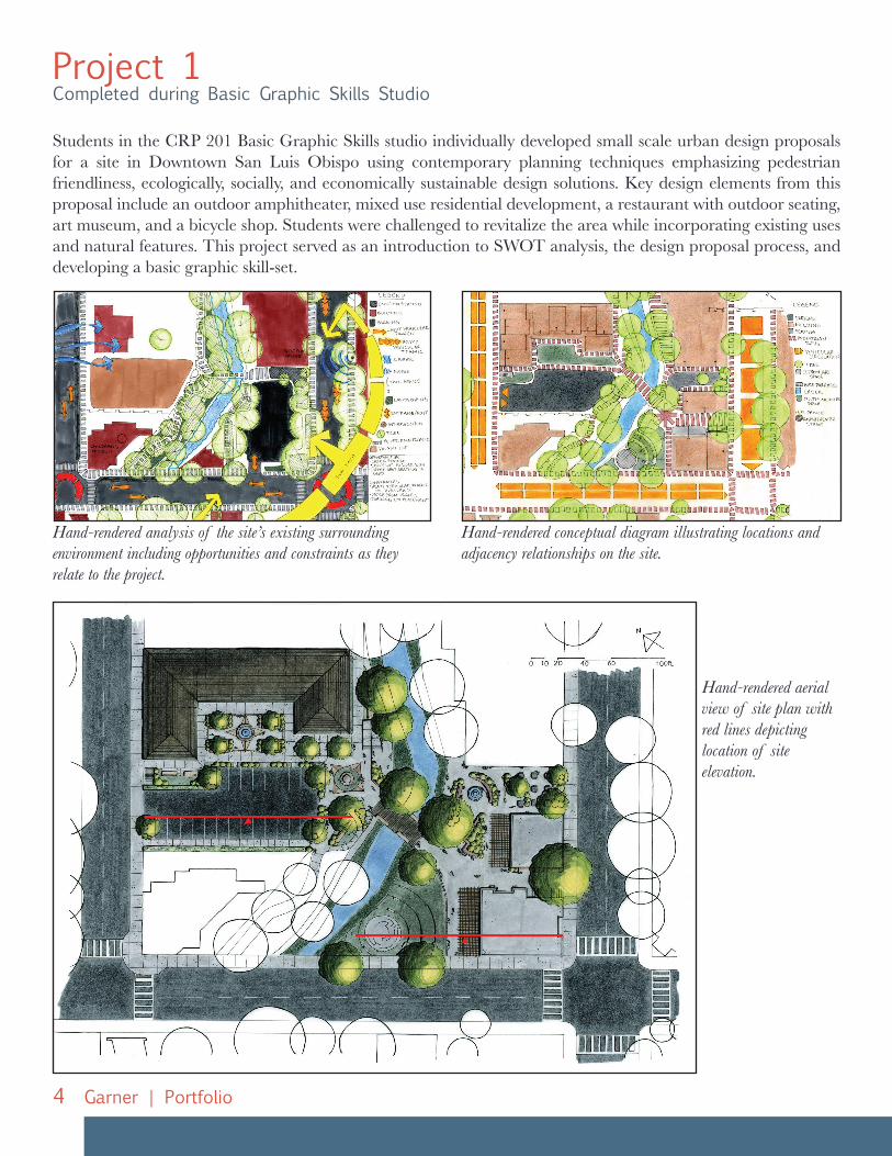
Project 1Completed during Basic Graphic Skills Studio
Students in the CRP 201 Basic Graphic Skills studio individually developed small scale urban design proposals for a site in Downtown San Luis Obispo using contemporary planning techniques emphasizing pedestrian friendliness, ecologically, socially, and economically sustainable design solutions. Key design elements from this proposal include an outdoor amphitheater, mixed use residential development, a restaurant with outdoor seating, art museum, and a bicycle shop. Students were challenged to revitalize the area while incorporating existing uses and natural features. This project served as an introduction to SWOT analysis, the design proposal process, and developing a basic graphic skill-set.
Hand-rendered aerial view of site plan with red lines depicting location of site elevation.
Hand-rendered analysis of the site’s existing surrounding environment including opportunities and constraints as they relate to the project.
Hand-rendered conceptual diagram illustrating locations and adjacency relationships on the site.
5Garner | Portfolio
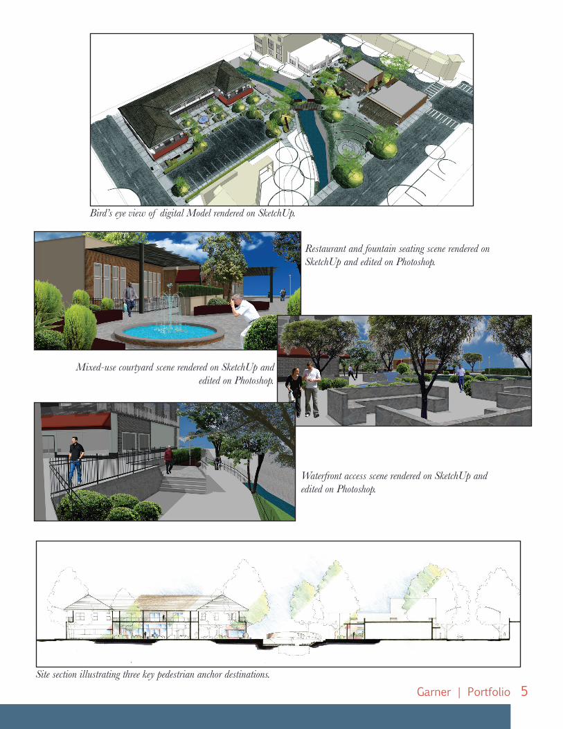
Bird’s eye view of digital Model rendered on SketchUp.
Site section illustrating three key pedestrian anchor destinations.
Restaurant and fountain seating scene rendered on SketchUp and edited on Photoshop.
Mixed-use courtyard scene rendered on SketchUp and edited on Photoshop.
Waterfront access scene rendered on SketchUp and edited on Photoshop.
6 Garner | Portfolio
Project 2Completed during Urban Design Studio II
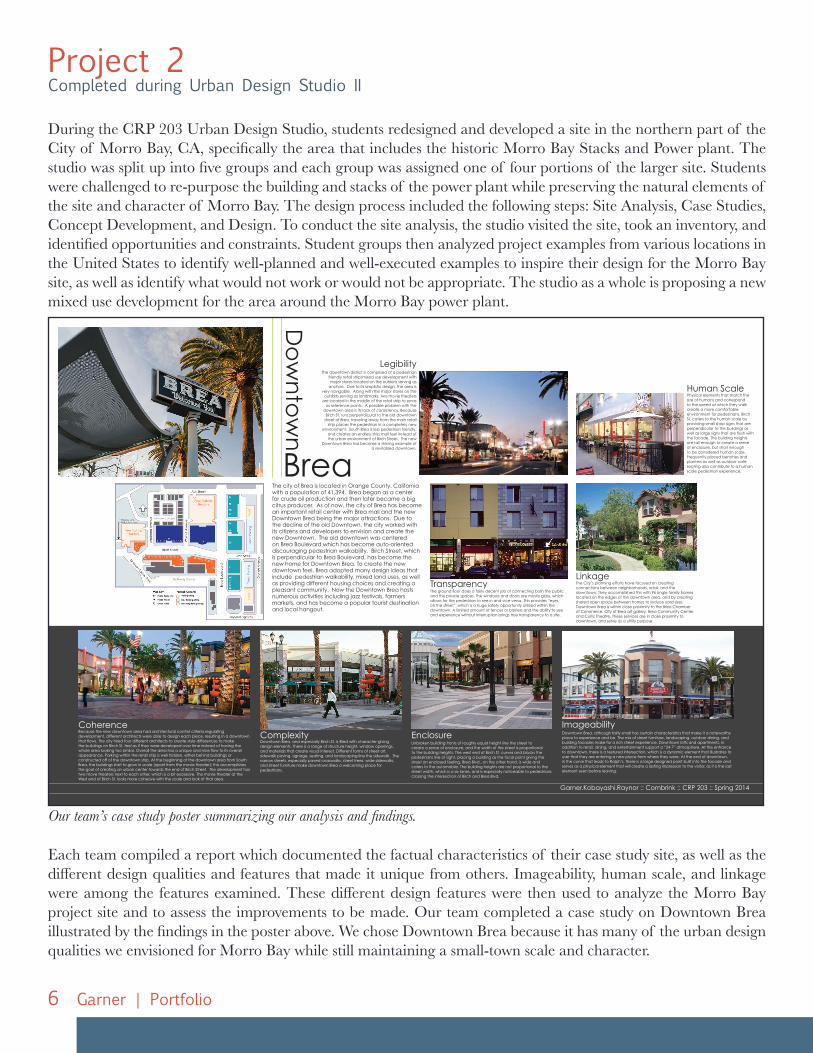
During the CRP 203 Urban Design Studio, students redesigned and developed a site in the northern part of the City of Morro Bay, CA, specifically the area that includes the historic Morro Bay Stacks and Power plant. The studio was split up into five groups and each group was assigned one of four portions of the larger site. Students were challenged to re-purpose the building and stacks of the power plant while preserving the natural elements of the site and character of Morro Bay. The design process included the following steps: Site Analysis, Case Studies, Concept Development, and Design. To conduct the site analysis, the studio visited the site, took an inventory, and identified opportunities and constraints. Student groups then analyzed project examples from various locations in the United States to identify well-planned and well-executed examples to inspire their design for the Morro Bay site, as well as identify what would not work or would not be appropriate. The studio as a whole is proposing a new mixed use development for the area around the Morro Bay power plant.
Garner.Kobayashi.Raynor :: Combrink :: CRP 203 :: Spring 2014
The city of Brea is located in Orange County, California with a population of 41,394. Brea began as a center for crude oil production and then later became a big citrus producer. As of now, the city of Brea has become an important retail center with Brea mall and the new Downtown Brea being the major attractions. Due to the decline of the old Downtown, the city worked with its citizens and developers to envision and create the new Downtown. The old downtown was centered on Brea Boulevard which has become auto-oriented discouraging pedestrian walkability. Birch Street, which is perpendicular to Brea Boulevard, has become the new home for Downtown Brea. To create the new downtown feel, Brea adopted many design ideas that include pedestrian walkability, mixed land uses, as well as providing different housing choices and creating a pleasant community. Now the Downtown Brea hosts numerous activities including jazz festivals, farmers markets, and has become a popular tourist destination and local hangout.
Do
wn
tow
n
Brea
Physical elements that match the size of humans and correspond to the speed at which they walk create a more comfortable environment for pedestrians. Birch St. caters to the human scale by providing small shop signs that are perpendicular to the buildings as well as large signs that are flush with the facade. The building heights are tall enough to create a sense of enclosure, but short enough to be considered human scale. Frequently placed benches and planters as well as outdoor cafe seating also contribute to a human scale pedestrian experience.
Downtown Brea, although fairly small has certain characteristics that make it a noteworthy place to experience and be. The mix of street furniture, landscaping, outdoor dining, and building facades make for a rich street experience. Downtown lofts and apartments, in addition to retail, dining, and entertainment support a “24-7” atmosphere. At the entrance to downtown, there is a textured intersection, which is a dynamic element that illustrates to user that they are entering a new place from where they were. At the end of downtown, in the curve that leads to Ralph’s, there is a large designed point built into the facade and serves as a physical element that will create a lasting impression to the visitor, as it is the last element seen before leaving.
The ground floor does a fairly decent job of connecting both the public and the private spaces. The windows and doors are mostly glass, which allows for the pedestrian to see in and vice versa. This provides “eyes on the street”, which is a huge safety opportunity utilized within the downtown. A limited amount of fences or barriers and the ability to see and experience without interruption brings true transparency to a site.
Unbroken building fronts of roughly equal height line the street to create a sense of enclosure, and the width of the street is proportional to the building heights. The west end of Birch St. curves and blocks the pedestrians line of sight, placing a building as the focal point giving the street an enclosed feeling. Brea Blvd., on the other hand, is wide and caters to the automobile. The building heights are not proportional to the street width, which is a six lanes, and is especially noticeable to pedestrians crossing the intersection of Birch and Brea Blvd.
The City’s planning efforts have focused on creating connections between neighborhoods, retail, and the downtown. They accomplished this with 96 single family homes located on the edges of the downtown area, and by creating shared open space between homes to reduce yard sizes. Downtown Brea is within close proximity to the Brea Chamber of Commerce, City of Brea art gallery, Brea Community Center, and Curtis Theatre. These services are in close proximity to downtown, and serve as a utility purpose.
The downtown district is comprised of a pedestrian friendly retail strip/mixed use development with major stores located on the outskirts serving as
anchors. Due to its simplistic design, the area is very navigable. Along with the major stores on the
outskirts serving as landmarks, two movie theaters are located in the middle of the retail strip to serve
as reference points. A possible problem with the downtown area is its lack of consistency. Because
Birch St. runs perpendicular to the old downtown street of Brea, traveling away from the main retail
strip places the pedestrian in a completely new environment. South Brea is less pedestrian friendly,
and creates an endless strip mall feel instead of the urban environment of Birch Street. The new
Downtown Brea has become a shining example of a revitalized downtown.
Imageability
Legibility
Enclosure
Human Scale
TransparencyLinkage
Coherence
Downtown Brea, and especially Birch St. is filled with character-giving design elements. There is a range of structure height, window openings, and materials that create visual interest. Different forms of street art, sidewalk paving, signage, seating, and landscaping line the sidewalk. The narrow streets, especially paved crosswalks, street trees, wide sidewalks, and street furniture make downtown Brea a welcoming place for pedestrians.
ComplexityBecause the new downtown area had architectural control criteria regulating development, different architects were able to design each piece, resulting in a downtown that flows. The city hired four different architects to create style differences to make the buildings on Birch St. feel as if they were developed over time instead of having the whole area looking too similar. Overall the area has a unique and nice flow to its overall appearance. Parking within the retail strip is well hidden, either behind buildings or constructed off of the downtown strip. At the beginning of the downtown area from South Brea, the buildings start to grow in scale (apart from the movie theater); this accomplishes the goal of creating an urban center towards the end of Birch Street. The development has two move theaters next to each other, which is a bit excessive. The movie theater at the West end of Birch St. looks more cohesive with the scale and look of that area.
Each team compiled a report which documented the factual characteristics of their case study site, as well as the different design qualities and features that made it unique from others. Imageability, human scale, and linkage were among the features examined. These different design features were then used to analyze the Morro Bay project site and to assess the improvements to be made. Our team completed a case study on Downtown Brea illustrated by the findings in the poster above. We chose Downtown Brea because it has many of the urban design qualities we envisioned for Morro Bay while still maintaining a small-town scale and character.
Our team’s case study poster summarizing our analysis and findings.
7Garner | Portfolio
A
B
1 2
3
4
5
67 8
9 10 11
12
13
Mo
rro B
ay
cross section A
street elevation B
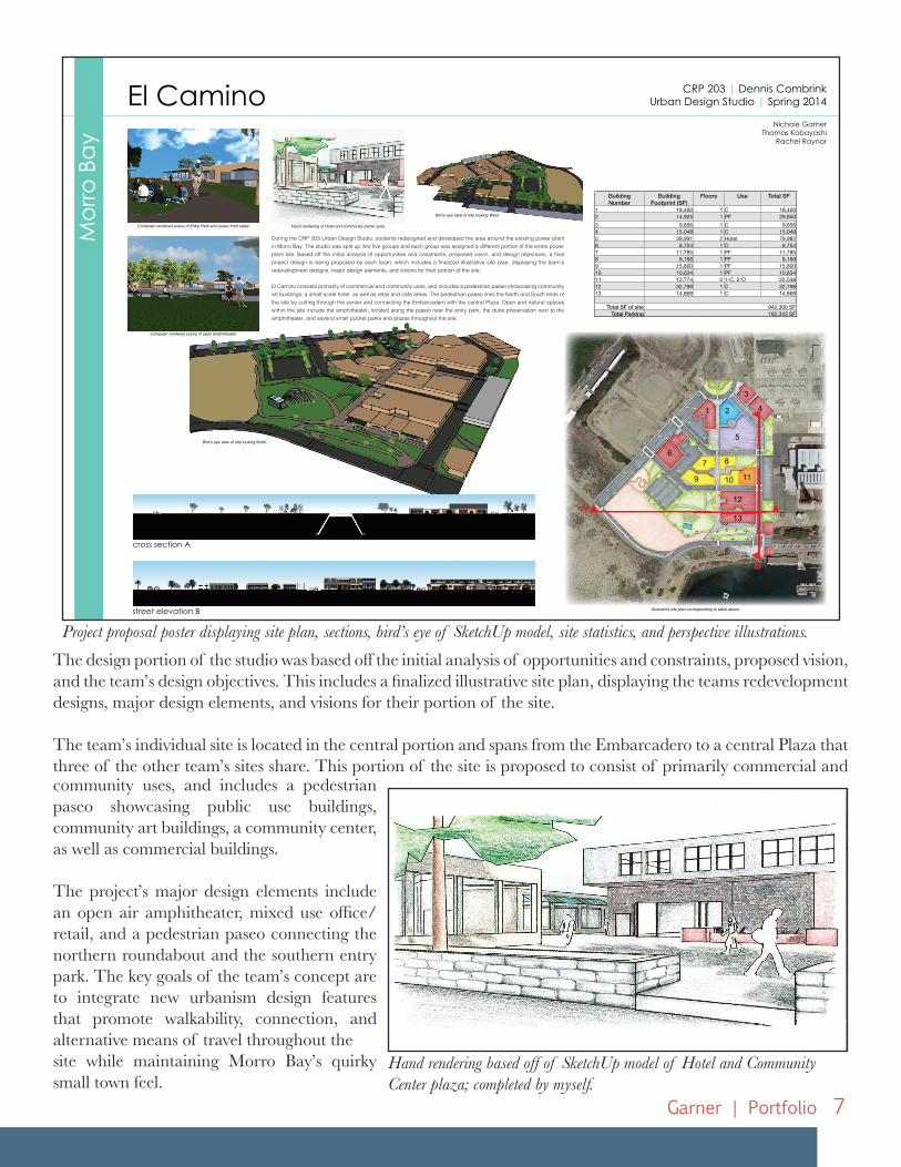
During the CRP 203 Urban Design Studio, students redesigned and developed the area around the existing power plant in Morro Bay. The studio was split up into five groups and each group was assigned a different portion of the entire power plant site. Based off the initial analysis of opportunities and constraints, proposed vision, and design objectives, a final project design is being proposed by each team, which includes a finalized illustrative site plan, displaying the team’s redevelopment designs, major design elements, and visions for their portion of the site.
El Camino consists primarily of commercial and community uses, and includes a pedestrian paseo showcasing community art buildings, a small-scale hotel, as well as retail and cafe areas. The pedestrian paseo links the North and South ends of the site by cutting through the center and connecting the Embarcadero with the central Plaza. Open and natural spaces within the site include the amphitheater, located along the paseo near the entry park, the dune preservation next to the amphitheater, and several small pocket parks and plazas throughout the site.
Nichole GarnerThomas Kobayashi
Rachel Raynor
CRP 203 | Dennis CombrinkUrban Design Studio | Spring 2014
Building Number
Building Footprint (SF)
Floors Use Total SF
1 18,400 1 C 18,4002 14,925 1 PF 29,8503 9,656 1 C 9,6564 15,048 1 C 15,0485 39,991 2 Hotel 79,9826 6,754 1 C 6,7547 11,785 1 PF 11,7858 8,188 1 PF 8,1889 15,800 1 PF 15,80010 10,634 1 PF 10,63411 12,774 2 1-C, 2-O 25,54812 32,798 1 C 32,79813 14,868 1 C 14,868
Total SF of site 942,300 SFTotal Parking 162,343 SF
El Camino
Computer rendered scene of Entry Park and ocean front cafes. Hand rendering of Hotel and community center area.
Bird’s eye view of site looking West.
Bird’s eye view of site looking North.
Computer rendered scene of open amphitheater.
Illustrative site plan corresponding to table above.
The design portion of the studio was based off the initial analysis of opportunities and constraints, proposed vision, and the team’s design objectives. This includes a finalized illustrative site plan, displaying the teams redevelopment designs, major design elements, and visions for their portion of the site.
The team’s individual site is located in the central portion and spans from the Embarcadero to a central Plaza that three of the other team’s sites share. This portion of the site is proposed to consist of primarily commercial and community uses, and includes a pedestrian paseo showcasing public use buildings, community art buildings, a community center, as well as commercial buildings.
The project’s major design elements include an open air amphitheater, mixed use office/ retail, and a pedestrian paseo connecting the northern roundabout and the southern entry park. The key goals of the team’s concept are to integrate new urbanism design features that promote walkability, connection, and alternative means of travel throughout thesite while maintaining Morro Bay’s quirky small town feel.
Hand rendering based off of SketchUp model of Hotel and Community Center plaza; completed by myself.
Project proposal poster displaying site plan, sections, bird’s eye of SketchUp model, site statistics, and perspective illustrations.
8 Garner | Portfolio
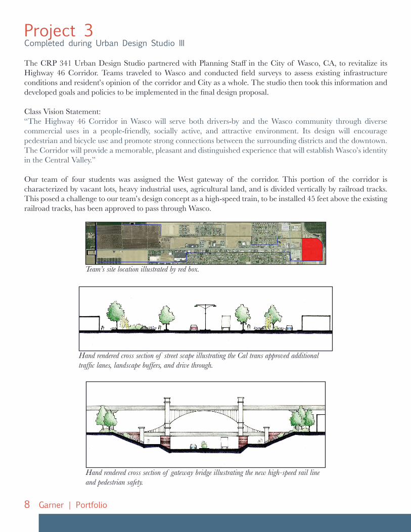
Project 3Completed during Urban Design Studio III
The CRP 341 Urban Design Studio partnered with Planning Staff in the City of Wasco, CA, to revitalize its Highway 46 Corridor. Teams traveled to Wasco and conducted field surveys to assess existing infrastructure conditions and resident’s opinion of the corridor and City as a whole. The studio then took this information and developed goals and policies to be implemented in the final design proposal.
Class Vision Statement:“The Highway 46 Corridor in Wasco will serve both drivers-by and the Wasco community through diverse commercial uses in a people-friendly, socially active, and attractive environment. Its design will encourage pedestrian and bicycle use and promote strong connections between the surrounding districts and the downtown. The Corridor will provide a memorable, pleasant and distinguished experience that will establish Wasco’s identity in the Central Valley.”
Our team of four students was assigned the West gateway of the corridor. This portion of the corridor is characterized by vacant lots, heavy industrial uses, agricultural land, and is divided vertically by railroad tracks. This posed a challenge to our team’s design concept as a high-speed train, to be installed 45 feet above the existing railroad tracks, has been approved to pass through Wasco.
Hand rendered cross section of street scape illustrating the Cal trans approved additional traffic lanes, landscape buffers, and drive through.
Hand rendered cross section of gateway bridge illustrating the new high-speed rail line and pedestrian safety.
Team’s site location illustrated by red box.
9Garner | Portfolio
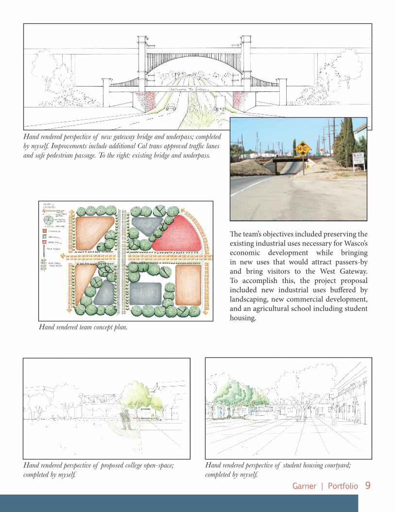
Hand rendered team concept plan.
Hand rendered perspective of new gateway bridge and underpass; completed by myself. Improvements include additional Cal trans approved traffic lanes and safe pedestrian passage. To the right: existing bridge and underpass.
Hand rendered perspective of proposed college open-space; completed by myself.
Hand rendered perspective of student housing courtyard; completed by myself.
The team’s objectives included preserving the existing industrial uses necessary for Wasco’s economic development while bringing in new uses that would attract passers-by and bring visitors to the West Gateway. To accomplish this, the project proposal included new industrial uses buffered by landscaping, new commercial development, and an agricultural school including student housing.


![Garner Transcripts 1[1]](https://img.pdfslide.us/doc/110x75/547c0b85b4af9fea158b5003/garner-transcripts-11.jpg)