Embed Size (px)
Citation preview

GANGTOK Slum Free City Plan of Action

The capital city of the state of Sikkim
Largest city with a total population of 100,086 in 2011
Accounts for about 65% of the total urban population of Sikkim
Population increased from 29,354 in 2001 to 100,086 in 2011
Besides, natural increase and net in-migration, this phenomenal
population increase in last decade is also due to revision of city
boundary.
The total area under Gangtok Municipal Corporation is 19.63 sq. km
Population density in Gangtok municipal area is 52 persons / ha.
Total number of wards in the city is 15
Percentage of slum population to total population is 23.51%
Percentage of slum households to total households is 25.60%
GANGTOK An Introduction
GANGTOK: Slum Free City Plan of Action Initiation Stage
INITIATION Sharing
Slum Situation
Finalizing Slum Definition
Based on Gazette Notification of 2003
Meeting with various stakeholders,
(Duration : FEB ’12 to May ’13)
Visit to all slums
by HUDCO Team(Duration : Nov ’12
to May ’13)
Resolution of ULB/ concerned state
government dept.for preparation of Slum free City Plan
Stakeholder Identification
Establishment of RAY technical Cell

GANGTOK: Slum Free City Plan of Action Defining Slum
“A slum is a cluster of compact settlements of 5 or more households which generally grow very unsystematically and haphazardly in an unhealthy condition and atmosphere on government and private vacant land. Slums also exist in the owner based household premises.”

GA
NG
TO
K: S
lum
Fre
e C
ity P
lan
of A
ctio
n
Ward
wis
e L
ist o
f Slu
ms

GANGTOK: Slum Free City Plan of Action Preparatory Stage
FINALIZATION OF LIST OF SLUMS WITH LOCATION AND SLUM BOUNDARIES
SOCIO-ECONOMIC HOUSEHOLD SURVEY of SLUMSSpatial distributionDemographic featuresSocio-economic conditions Physical infrastructure
GIS MAPPING Review of the Existing Spatial Data Satellite ImageGe-referencing spatial data and
information
MISHoisting data in designated Govt. of India website
DIALOGUE WITH BENEFICIARIES FOR AWARENESS & CONSENSUS BUILDING
Card Issued to Households after Conducting Household level socio-economic Survey

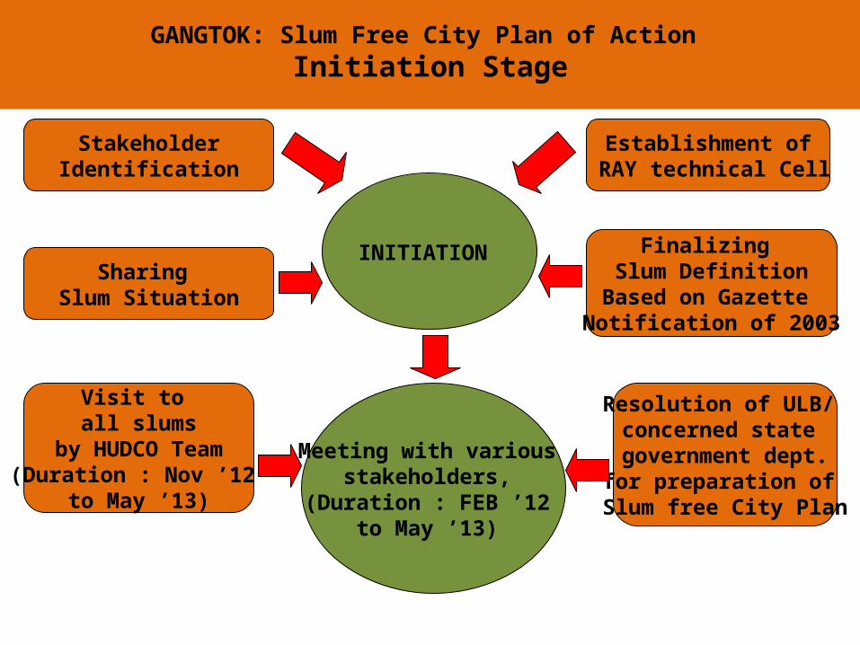
GANGTOK: Slum Free City Plan of Action Slum Situation: Assessment
58 Total Number of Slums
12 Notified Slums
46 Non- notified Slums
78% slum population in notified slums
23580 Total Slum Population
6085 Total Slum Households
6 Slums with no. of HHs <5
1.15 sq. km Area Under Slums
205 p/ha Average Density in Slums
75.86% Slums in Private
Land 8.28%% BPL HHs in Slums
GANGTOK: Slum Free City Plan of Action Slum Situation: Assessment
70% Pucca slum houses
3 slums with no pucca house
79% Slum HHs are ‘rented’
occupants
79% HHs have access to tap water
within premises 12No. of Slums in Chandmari
ward (highest)
4961Slum population in Arithang (maximum)
1316Total No. of HHs in the biggest
slum – Slaughter House

GANGTOK: Slum Free City Plan of Action Slums in Gangtok R
em
ote
Scatte
red
& In
accessib
le
Locatio
ns

GANGTOK: Slum Free City Plan of Action Slums in Gangtok
Pre
cario
us &
Vu
lnera
ble
Site

GANGTOK: Slum Free City Plan of Action Slums in Gangtok U
nsafe
& In
ad
eq
uate
Hou
sin
g

GANGTOK: Slum Free City Plan of Action Slums in Gangtok
Insu
fficie
nt &
Inad
eq
uate
In
frastru
ctu
re

GANGTOK: Slum Free City Plan of Action The Challenges
No. of slums appears to be limited (58), but proportion of
slum households to total households is 23.51% which is much
higher than the national average of 17% as per Census 2011.
The slums are scattered all over the city but in varying
degrees. 38 out of 58 slums and for 69% of the total slum
households are in core areas.
Percentage of slum population varies from 2.63% of total
population in the Daragaon Ward to 61.58% of the population
(Diesel Power House).
Most of the slums are of small, when expressed in terms of
no. of HHs in slums.
The BPL HHs to slum households around 8%.
Most of the slums are in private land.
Most of the slum HHs are ‘rented’ occupants.
Limited Land supply for residential development by public
agencies
Constrained land supply due to hostile / incompatible terrain.

GANGTOK: Slum Free City Plan of Action Tenability Analysis
Guiding Principle:
Sustainable and pro-people interventions without compromising the ‘larger’ interest of environment, ecology or city development.
Un-tenability status primarily assigned to only those slums that poses a threat to the life of the inhabitants by virtue of it being located in sites vulnerable to natural disasters or ecologically fragile.
Tenability defined based on composite score of vulnerability to hazards like earthquake, landslide, slope & flash flood.
Slums falling in the last two categories i.e. Medium High and Very High have been recommended as “Untenable”.

GANGTOK: Slum Free City Plan of Action Tenability Analysis
Based on the composite score derived from vulnerability to multiple natural disasters, each slum has been categorized into following vulnerability categories:
Low Medium Low Medium Medium High Very High.
Slums falling in the last two categories i.e. Medium High and Very High have been recommended as “Untenable”.
Multi hazard map is based on micro level data and that slums return composite score of more than one category. In such cases, the category that has the maximum percentage area is taken as the deciding category for that slum.

GANGTOK: Slum Free City Plan of Action Tenability Analysis
No. of households and population in slums assigned ‘untenable’ status accounts only 1.3 and 1.5 % of slum HHs and population respectively.
Additional land requirement for slum free city is minimal
Small size being small, affected population can be accommodated in redevelopment sites within the same ward.
5 Untenable
slums based on vulnerability to natural disaster
1Untenable
slum due to land
ownership
363Total
population living in
Untenable Slums

GANGTOK: Slum Free City Plan of Action Prioritization of Slums
List of Chosen for Indicators Prioritization
Socio-Economic Vulnerability :– % of unemployed population to total population in the slum (1.5)– % of HHs with monthly income less than Rs. 3000/-, to total
households in the slum (4)– % age of Illiterate population to total population in the slum (1.5)– % of BPL HHs to total households in the slum (2)– % age of ST+SC HHs to total households in the slum (0.5)
Housing Vulnerability :– % of Kutcha Dwelling Units to totals DUs in the slum (6)– % of Semi-pucca Dwelling Units to totals DUs in the slum (6)
Infrastructure Vulnerability :– % of HHs without Tap water to total households in the slum (3)– % HHs engaged in Open Defecation to total HHs in the slum (1.5)– % of HHs with access to Kutcha Roads to total HHs in the slum (1)– % HH not connected to drainage facilities to total HHs in the slum
(1.5)– % HHs connected to sewerage facilities to total HHs in the slum (1.5)– Availability of street light facility within the slum (1)

GANGTOK: Slum Free City Plan of Action Prioritization of Slums
First Priority Slums: score value of 2 and 3 in all three parameters. The most vulnerable being slum with 3 X 3 X 3 score e.g. Kanchan Colony and Dui Mile.
Second Priority Slums: Score value 2 and 3 for housing and infrastructureand1 for economic status. 20 slums in this category.
Third priority slums: Slums that registers score value 1 in at least one parameter. There are 20 slums in this category. Slum Star Hall and Chandmari have a matrix score of 1 X 1 X 1 implying they are the least vulnerable in terms of socio-economic, housing & infrastructure index.
Final Range Code 1: Capable Final Range Code 2: Medium
Final Range Code 3: Vulnerable

GANGTOK: Slum Free City Plan of Action Prioritization of Slums: Refinement
Criteria for refinement of slum prioritization All slums in Govt. land irrespective of the department is considered as first priority.
All slums that required ‘relocation’ due to tenability status :-
Vulnerable / prone to multiple hazards
The relocation plan can be combined with the redevelopment plans of listed slums in the same ward
Except the slum ‘Beside Bhanugram,’ in Arithang ward all are in Government land
All slums in ‘private’ land has been categorized in Second and Third Priority based on the Vulnerability Index value to allow ‘preparatory’ phase to finalize the development options and strategies

GANGTOK: Slum Free City Plan of Action Development Options
Challenges for implementing development options: Private Land Non-Sikkimese
migrant occupant. Unwillingness of the
landlords to pay & participate in development interventions.
Unwillingness of the tenants to participate due to insecurity of tenure.
Requires Consensus Building % Capacity enhancement.

GANGTOK: Slum Free City Plan of Action Estimated Investment Requirement

GANGTOK: Slum Free City Plan of Action Preventive Strategy
Creation of Adequate Housing Stock
Absolute shortage is NIL in
GMC area The current housing
shortage calculated based
on katcha & obsolescent
houses are 2399 . Population projected for
2025 is 1,48,006. Total DUs requirement by
2025 is 37006 based on avg.
HH size. Total DUs requirement for
EWS category by 2025 is
estiomated to be 4254 units.
(@ 33% of the total Housing
Stock).
Challenges towards Housing Supply
Nature of land unsuitable for residential development.
Fragile environment and terrain that limits the possibility of high rise high density development.
Substantial number of slums are in ‘forest’ land limiting the possibility of regularization.
Stringent land laws
Restrictive ownership laws.
Absence of public agency in supply of housing

20-25% Land reservation for EWS & LIG with a system
of cross subsidization
Implementation of Rent Control Act
Enactment of user Charges
To secure Credit from Bank & Financial Institutions
To create Shelter Fund
Introduce & Implement State Housing and Habitat
Policy
Formulation of Apartment Ownership Act and
Cooperative housing act
Enforcement of safety standards in buildings Enforcement of proper site selection and usage of earthquake resistant features in buildings to prevent loss of housing stock in natural occurrence.
GANGTOK: Slum Free City Plan of Action Necessary reforms

A new Planning or Development Authority under the control
of UD & H Deptt. may be formed as an autonomous bBody for
development of the Greater Gangtok Area.
UD & H Deptt., Govt. of Sikkim will act as a facilitator.
Devolution of power as per 74th Constitutional Amendment to
the Gangtok Municipal Corporation.
SUDA to be structured for taking up Slum Improvement &
Relocation works in Gangtok in association with other
implementing agencies.
SHDB may be revived for undertaking formal layout based
housing project.
Land Assembly Cell should be established.
Regional study to be done at macro level for assessing the
Regional vulnerability and understand the extent of carrying
capacity of city of Gangtok.
GANGTOK: Slum Free City Plan of Action Recommendations for Institutional Arrangements

THANK YOU