Embed Size (px)
Citation preview

Galileo as a multi-purpose source of space-generated big dataSpace Forum 2019
22 May 2019, Luxembourg
Omar Valdés – Market Development Officer

Big data
Why using Galileo?
Securing the data
Agenda
2
GSA and EGNSS in a nutshell

Securing the data
Big data
Why using Galileo?
Agenda
3
GSA and EGNSS in a nutshell

The European GNSS Agency (GSA) is responsible for market development and operations of Galileo and EGNOS
4
• Staff: around 160• Nationalities: 22• Headquarters: Prague, Czech Republic • Other Locations:
• France• The Netherlands
• Spain• United Kingdom
The GSA’s mission is to support European Union objectives and achieve the highest return on
European GNSS investment, in terms of benefits to users and economic growth and competitiveness

Galileo is the European GNSS offering a wide range of services
Open Service (OS)
High Accuracy Service (HAS)
Search and Rescue Service (SAR)
Public Regulated Service (PRS)
Galileo open and free of charge service set up for positioning and timing services
Service restricted to government-authorised users, for sensitive applications that require a high level of service continuity
Europe’s contribution to COSPAS-SARSAT, an international satellite-based search and rescue distress alert detection system
A service complementing the OS by providing an additional navigation signal and added-value services in a different frequency band. The HAS signal can be encrypted in order to control the access to the Galileo HAS services
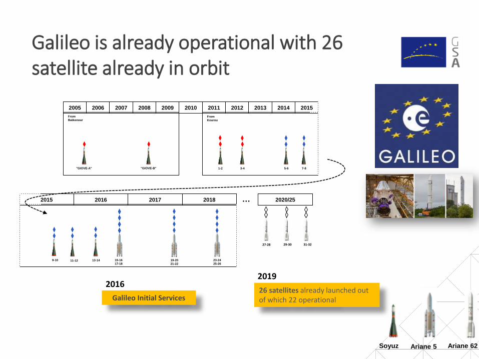
Galileo is already operational with 26 satellite already in orbit
31-3227-28 29-30
2005 2006 2007 2008 2009 2010 2011 2012 2013 2014 2015
2016
"GIOVE-A" "GIOVE-B" 1-2 3-4 5-6 7-8
From
BaïkonourFrom
Kourou
2017 2018 2020/25
9-10
2015
15-16
17-1811-12
Soyuz Ariane 5
19-20
21-22
23-24
25-2613-14
Galileo Initial Services26 satellites already launched out of which 22 operational
Ariane 62
…
20192016

Securing the data
Big Data
GSA and EGNSS in a nutshell
Agenda
8
Why using Galileo?

The current Galileo added value in mass market
Multi-constellation
Multipath Resistant
Multi-constellation
Dual frequency GNSS smartphones
Multipath Resistant
= Galileo differentiator= Galileo together other GNSS
Dual frequency GNSS smartphones
Better positioning in urban environments
Development of newvalue-added services
Enhancement of offered ones
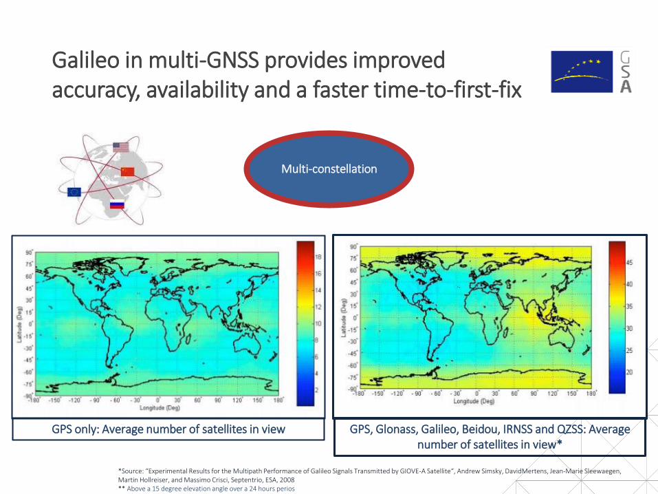
Multi-constellation
*Source: “Experimental Results for the Multipath Performance of Galileo Signals Transmitted by GIOVE-A Satellite“, Andrew Simsky, DavidMertens, Jean-Marie Sleewaegen, Martin Hollreiser, and Massimo Crisci, Septentrio, ESA, 2008** Above a 15 degree elevation angle over a 24 hours perios
GPS only: Average number of satellites in view GPS, Glonass, Galileo, Beidou, IRNSS and QZSS: Average number of satellites in view*
Galileo in multi-GNSS provides improved accuracy, availability and a faster time-to-first-fix

Multipath Resistant
**Source: “Estimating the Time-To-First-Fix for GNSS Signals Theory and Simulation Results”‘ Marco Anghileri, Matteo Paonni, Stefan Wallner, José-Ángel Ávila-Rodríguez, Bernd Eissfeller, Institute of Geodesy and Navigation, University FAF Munich, Germany’
The strength of Galileo signal, together with an advanced code modulations, makes Galileo better mitigating multipath effects (especially in E5, but also E1)**
Galileo improves GNSS location in challenging urban environments

• Availability of raw GNSS measurements
• Entry into the market of dual frequency GNSS receivers smartphones:
Dual frequency receivers and raw measurements will enable innovative apps
12
‒ XiaomiM8, presented in June 2018, is the first phone using a dual frequency chipset (BCM47755 by Broadcom)
‒ By using L1 and L5 frequency bands, It is able to provide an accuracy up to 30 cm
‒ Galileo is the GNSS currently providing the biggest number of L5 satellites
HUAWEI Mate 20
Dual frequency GNSS
smartphones
Dual frequency GNSS
smartphones
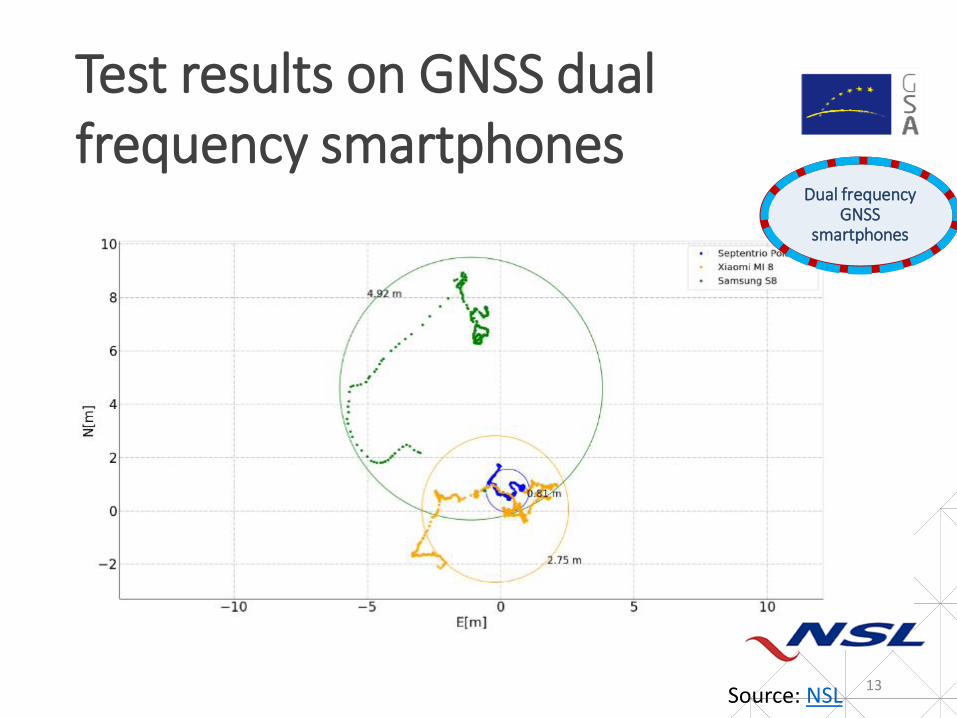
Test results on GNSS dual frequency smartphones
13Source: NSL
Dual frequency GNSS
smartphones
Dual frequency GNSS
smartphones

Dual frequency and Galileo
14
Dual frequency GNSS
smartphones
Dual frequency GNSS
smartphones

Securing the data
GSA and EGNSS in a nutshell
Why using Galileo?
Agenda
15
Big data

1. “Classic”: PVT processed in the receiver and provided to the application as processing data
2. External processing of “Raw data” for PVT estimation
Two approaches for positioning processing
16
2
1
Generic block diagram of a GNSS receiver (source: https://www.gsa.europa.eu/system/files/reports/gnss_raw_measurement_web_0.pdf)

PVT provided to the application already processed receiver in a suitable format (e.g. RINEX, NMEA)
The classic approach
17
$GPGGA,132318.00,5005.8586,N,01426.0729,E,1,15,01.0,207.0,M,45.5,M,,*5C$GPRMC,132318.00,A,5005.8586,N,01426.0729,E,00.00,092.8,250815,,,A*52$GPGSV,5,1,17,07,12,314,42,08,23,296,34,13,07,025,22,15,14,056,32*7D$GPGSV,5,2,17,16,55,215,49,18,56,104,29,19,20,293,39,20,14,042,24*7F$GPGSV,5,3,17,21,44,068,27,22,43,167,36,26,32,187,43,27,63,297,45*72$GPGSV,5,4,17,33,26,216,44,37,32,170,,39,32,166,37,40,21,131,*76$GPGSV,5,5,17,49,32,192,*49$GLGSV,3,1,10,65,50,096,02,66,23,159,34,72,26,032,,78,08,220,16*66$GLGSV,3,2,10,79,30,262,41,80,22,328,35,81,65,329,43,82,07,286,37*6C$GLGSV,3,3,10,87,11,094,,88,56,069,*6A$GAGSV,1,1,02,162,34,281,44,169,11,169,00*63$GNGSA,A,3,27,18,22,07,26,16,08,19,,,,,01.6,01.0,01.2*11$GNGSA,A,3,162,,,,,,,,,,,,01.6,01.0,01.2*2C$GNGSA,A,3,66,78,79,80,81,82,,,,,,,01.6,01.0,01.2*13$PORZD,A,016.1*3A
$GPGGA,132319.00,5005.8586,N,01426.0729,E,1,15,01.0,207.0,M,45.5,M,,*5D
• Continuous tracking with 1 Hz frequency
• 1 sec data block
• $GPGSV: GPS satellite tracked
• $GLGSV: GLONASS satellite tracked
• $GAGSV: Galileo satellite tracked
• New second block begins

• For the previous example one hour of continuous tracking resulted in roughly 3MB of data
• For example:
‒ Luxembourg City had by 01/01/2017 174 buses1
‒ Assuming that continuous tracking as presented before of the bus fleet is desired
‒ The amount of data generated every day would be:
174 x 3MB/hour x 12 hours/day ~ 6,3 TB/day
‒ Assuming only positioning data is necessary!
‒ If other data is necessary, the amount would be even greater
The classic approach
181 https://www.vdl.lu/sites/default/files/media/document/Le%20r%C3%A9seau%20en%20chiffres.pdf

• Raw measurements are extracted from the receiver
• They are transferred somewhere else via a data channel
• The PVT is estimated “somewhere else” using a computing platform
External processing of raw data
19
# Raw
ElapsedRealtimeNanosSystemClock TimeNanos LeapSecond
TimeUncertaintyNanos FullBiasNanos BiasNanos BiasUncertaintyNanos
DriftNanosPerSecond
DriftUncertaintyNanosPerSecond
HardwareClockDiscontinuityCount SVID
TimeOffsetNanos State
ReceivedSVTimeNanos
ReceivedSVTimeUncertaintyNanos Cn0DbHz
PseudorangeRateMetersPerSecond
PseudorangeRateUncertaintyMetersPerSecond
AccumulatedDeltaRangeState
AccumulatedDeltaRangeMeters
AccumulatedDeltaRangeUncertaintyMeters
CarrierFrequencyHz
CarrierCycles
CarrierPhase
CarrierPhaseUncertainty
MultipathIndicator SNRInDb
ConstellationType
#
Raw 135606 75418000000 -1.19669E+18 0 13.23280023 0 2 0 47 3.95E+14 61 23.71351242 -7.5321121 0.305104553 6 -867.37607 3.40E+38 0 1
Raw 135607 75418000000 -1.19669E+18 0 13.23280023 0 5 0 47 3.95E+14 94 16.26821327 -633.52109 4.200237801 6 -42004.792 3.40E+38 0 1
Raw 135607 75418000000 -1.19669E+18 0 13.23280023 0 6 0 47 3.95E+14 37 27.96049881 457.666486 0.187633808 3 30857.606 0.00342582 0 1
Raw 135607 75418000000 -1.19669E+18 0 13.23280023 0 7 0 47 3.95E+14 26 30.86655998 -289.41956 0.135272371 6 -20367.979 3.40E+38 0 1
Raw 135607 75418000000 -1.19669E+18 0 13.23280023 0 9 0 47 3.95E+14 11 38.48816299 230.254993 0.057577176 3 15748.575 0.001081328 0 1
Raw 135607 75418000000 -1.19669E+18 0 13.23280023 0 16 0 47 3.95E+14 37 27.94695663 41.0942701 0.19056277 3 1226.9034 0.003431165 0 1
Full bias ns
Cn0 DbHz
Pseudorangem/s

• The previous slide shows an abstract of the raw data recorded for a 160 minutes observation session
• The whole data file measures roughly 31MB
• Applying this scenario to the Luxembourg’s buses example:
174 x 11,6MB/hour x 12 hours/day ~ 24 TB/day
• Under the same assumptions (only positioning data, no other data of the vehicles recorded)
• This solution then requires:
‒ More data capacity than the “classic” one
‒ More computing processing on the remote site
• But
‒ It reliefs the tracking device from a heavy computing charge
‒ Reduces battery consumption
‒ Enables tracking on applications that have limited availability of power
External processing of raw data
20

• Vietnam passed legislation requiring all vehicles used for transport must be equipped with tracking devices
• According to the Director of the Transport Department in the Ministryof Transport of Vietnam the regulation requires tracking devices to send the following data to the concerned authority:
‒ Route itinerary.
‒ Speed: measured by GNSS chipset, and counter meter.
‒ Continuous driving time
‒ Working time of drivers in a day
• This resulted in:
‒ 2 billion data packs submitted every day
‒ 1,4 TB of data per day!
A real example
21

• Location-Based Services, e.g.:
‒ Smartphones producing geo-tagged pictures
‒ Augmented reality games
• IoT
• Road, e.g.:
‒ Fleet tracking (like shown in the Luxembourg’s buses example)
‒ Connected vehicles in general
• Time stamping of financial transactions
• Scientific applications
A few GNSS applications needing big data
22

Galileo impact in emerging mass market applications
GSA and EGNSS in a nutshell
The Galileo differentiators
Agenda
23
Securing the data

• Two main risks are well known to the use of GNSS data:
‒ Jamming
Blocking the reception of GNSS signals by tone signals emitted in the GSNSS frequency rates: studies going on to limit its impact but so far it can be easily detected and reported
‒ Spoofing
Altering the PVT solution by emitting signals that replicate those emitted by the GNSS satellites so that an inaccurate solution is reported (e.g. the receiver believes it is in Luxembourg while it is in Prague)
Risks to GNSS data
24

Overcoming spoofing
= Galileo differentiator
Development of newvalue-added services
Enhancement of offered ones
Galileo NMA Authentication
Galileo CS Authentication
Need for authentication emerges
from users to enhance Galileo value
proposition with regards to:
• Enabling commercially sensitive
applications
• Enhancing big data collection
Main applications: Law
enforcement, fraud management,
billing, payment by location…

• GNSS in general is a source of valuable space-generated data that can benefit from the technologies associated to big data and computing
• Galileo in particular can be valuable to making such solutions more secure by improving the quality and reliability of the collected data
• Stay tuned to the GSA website for R&D funding opportunities in these synergies
Concluding
26

• GSA fosters adoption of Galileo and EGNOS with funding opportunities:
‒ Horizon 2020 calls for development of GNSS applications
‒ Fundamental Elements R&D actions for the development of receiver technologies
• We also have actions to expand the market of European companies overseas. E.g.:
‒ BELS+ project http://www.belsproject.eu/
‒ GNSS.Asia https://gnss.asia/
THANK YOU FOR YOUR ATTENTION!
Check our funding opportunities!
27

Linking space to user needs
GSA Twitter - @EU_GNSSEGNOS Twitter - @EGNOSPortal
GNSS Facebook page
GNSS YouTube Channel
GNSS Market, Research & Development
GSA Newsletter
GNSS Slideshare Page (presentations)
European GNSS Agency LinkedIn Page
www.GSA.europa.eu
How to get in touch:
28