Embed Size (px)
Citation preview

- GIS
- Geospatial Data
- Spatial Data Infrastructure (SDI)
Key Concepts
LCSSD BBL: GeoNode – 10/20/2010 Galen Evans, [email protected]

A new approach to spatial data infrastructure focused around users and collaboration
What is GeoNode?
LCSSD BBL: GeoNode – 10/20/2010 Galen Evans, [email protected]

- Catalogue Existing Data
- Identify Data Needs
- Collect Missing Data
Distribute and manage data
- Develop Hazard Models
- Develop Vulnerability
Models- Develop Exposure Database
Conduct Risk
Modeling
- Urban Planning & Codes
- Works Projects - Cat Risk Financing- Public
Education - Response
PreparednessClimate Impact Modeling
Data Collection Risk Modeling Adaptation & Mitigation
GeoNode
Example: GeoNode for DRM
LCSSD BBL: GeoNode – 10/20/2010 Galen Evans, [email protected]

GeoData: It is out there… somewhere
??
Why GeoNode?
LCSSD BBL: GeoNode – 10/20/2010 Galen Evans, [email protected]

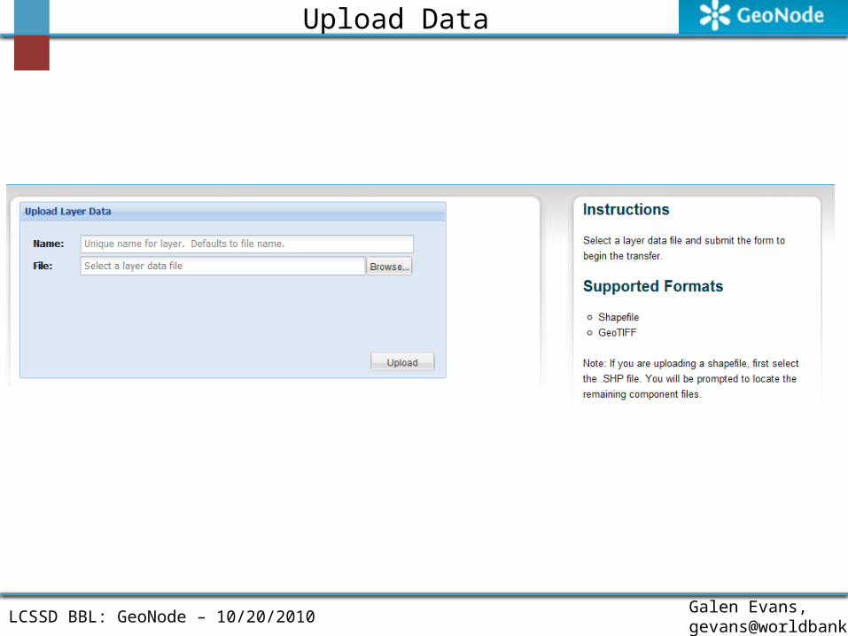
Makes publishing easy
• Upload data through the web
• Edit metadata in the same place
• Restrict access if you need to
GeoNode Features
LCSSD BBL: GeoNode – 10/20/2010 Galen Evans, [email protected]

Makes publishing useful• Convert to many output formats
– Google Earth works immediately after upload
• Build maps combining uploaded layers- Link, embed, download
• Style layers in context
GeoNode Features
LCSSD BBL: GeoNode – 10/20/2010 Galen Evans, [email protected]

Collect metadata– Provided through browser editor– Associated with users– What maps is a layer in?– What tags do other users add?
GeoNode Features
LCSSD BBL: GeoNode – 10/20/2010 Galen Evans, [email protected]

Metadata and the actual data in the same place and maintained through one easy-to-use interface.
View and Explore Data
LCSSD BBL: GeoNode – 10/20/2010 Galen Evans, [email protected]

Two GIS Analysts, both in the same organization
I really need a forests dataset…
Finally! Finished that forests dataset
Analyst A Analyst B
Use Case
LCSSD BBL: GeoNode – 10/20/2010 Galen Evans, [email protected]

GeoNode allows Analyst B to easily share the forests dataset with Analyst A – even if they don’t know each other
Analyst B Creates Data
Analyst B uploads data to
GeoNode
Analyst A finds and downloads
data
This allows for improved efficiency, and higher quality results
Use Case
LCSSD BBL: GeoNode – 10/20/2010 Galen Evans, [email protected]

Building a Community
• Users• Developers
Listserv - Users - Developers
IRC Channel
An open and transparent process
The Community
LCSSD BBL: GeoNode – 10/20/2010 Galen Evans, [email protected]

A Growing Community of Users and Potential Users
• Caribbean Community Climate Change Center• SEGEPLAN – Guatemala• Government of Peru• Government of St. Lucia• Government of St. Vincent• Government of Grenada• University of West Indies• Harvard University – Center for Geospatial Analysis• Oxford University – Archaeology Department• AfriSpatial• More – An Open Community!
The Community
LCSSD BBL: GeoNode – 10/20/2010 Galen Evans, [email protected]

• Social Networking features
• Federation
• Online editing
Moving Forward
LCSSD BBL: GeoNode – 10/20/2010 Galen Evans, [email protected]