Embed Size (px)
Citation preview

Examination Matters
GeographyA2
OCR
Contents
Introduction .................................................................................................................................................... 3
Exam advice .................................................................................................................................................... 4
Unit F763 Global Issues
Section A: structured questions and mark schemes
Generic mark scheme .............................................................................................................................................. 12
Environmental issues: questions 1–3 ................................................................................................................ 13
Economic issues: questions 4–6 .......................................................................................................................... 17
Section A: key content
Environmental issues: questions 1–3 ................................................................................................................ 20
Economic issues: questions 4–6 .......................................................................................................................... 24
Section B: essay questions and mark schemes
Environmental issues: Earth hazards: question 1 ........................................................................................ 28
Environmental issues: Ecosystems and environments under threat: question 2 .......................... 30
Environmental issues: Climatic hazards: question 3 .................................................................................. 32
Economic issues: Population and resources: question 4 .......................................................................... 34
Economic issues: Globalisation: question 5 .................................................................................................. 36
Economic issues: Development and inequalities: question 6 ................................................................ 38
Unit F764 Geographical Skills
Questions and mark schemes
Section A: structured questions
Geographical research: questions 1–3 ............................................................................................................ 41
Section A: mark schemes
Geographical research: questions 1–3 ............................................................................................................ 45
Section B: essay questions
Geographical investigations: questions 4 and 5 .......................................................................................... 52
Section B: mark schemes
Geographical investigations: questions 4 and 5 .......................................................................................... 54
2Examination Matters, supporting OCR A2 Geography, Raw © Philip Allan Updates
Introduction
Examination Matters consists of three parts. The first part (pages 4–11) provides generalexamination advice on matters such as schemes of assessment, exam technique and exampractice. The second part (pages 12–39) comprises specimen exam questions and mark schemesfor Unit F763 (Global Issues), and the final part (pages 40–55) provides specimen exam questionsand mark schemes for Unit F764 (Geographical Skills). The mark schemes give descriptions oflevels of attainment. An indication of the key content to include in your answer is given,identified by the symbol . In Section B of Unit F763 (Global Issues), an examiner’s commentary,identified by the symbol e, gives advice on what makes a good answer.
It is important to view the content of the specification and the methods of examination as awhole. Learning for the examination is best done with assessment methods firmly in mind.But before you attempt specific questions, you should consult the sections How to answer examquestions and Command words and phrases on pages 7–11.
The examination questions in this online material should be used in conjunction with the A2 textbook. Before attempting to answer the questions, read through the relevant sections inthe textbook. Then consult the mark schemes. These tell you how examiners mark your answers(i.e. what they look for and the criteria against which your answers are judged). Check also theguidance given on the content of good answers. For questions that demand examples,suggested case studies from the textbook are given in the examiner’s commentary.
3Examination Matters, supporting OCR A2 Geography, Raw © Philip Allan Updates
Exam advice
Scheme of assessmentTable 1.1 shows what you have to do in the written examinations for Units F763 and F764. Eachpaper consists of two Sections, A and B. In F763, Section A contains six data response questions:three on Environmental issues, and three on Economic issues. Candidates must answer threequestions, at least one from Environmental issues and one from Economic issues. Section B has12 open-ended essay questions, two for each option. (Only one question for each option isprovided in this online resource.) Candidates answer two essay questions, choosing one from theEnvironmental issues options and one from the Economic issues option.
The scheme of assessment for F764 is broadly similar. Section A comprises three structured, dataresponse questions based around various stimulus materials. Candidates answer one question.Section B includes two open-ended essay questions that examine fieldwork and research skills.Candidates answer both questions.
Table 1.1 A2 Scheme of assessment
F763 Global Issues� Section A: Three data response questions, at least one from Environmental issues (i.e. Earth
hazards, Ecosystems and Climatic hazards) and at least one from Economic issues (i.e.Population and resources, Globalisation, and Development and inequalities). Candidateschoose three from six questions.
� Section B: Two essay questions, one from Environmental issues (i.e. Earth hazards, Ecosystems,and Climatic hazards) and one from Economic issues (i.e. Population and resources,Globalisation, and Development and inequalities). Candidates select two from twelvequestions.
Unit% of A2assessment Style of assessment
Rawmarks
Uniformmarks
Timeallowed
F763Global Issues
60
Section A: answer three dataresponse questions. At least onemust be chosen from Environmental issues and one from Economic issues
30
120 2 1–2 hours
Section B: answer two essayquestions, one from Environmentalissues options and one fromEconomic issues options
60
F764GeographicalSkills
40
Section A: choose one structuredessay question
20
80 11–2 hours
Section B: answer both essayquestions
40
4Examination Matters, supporting OCR A2 Geography, Raw © Philip Allan Updates

F764 Geographical Skills� Section A: One data response question on the general stages of geographical investigation
(e.g. data collection, data analysis).� Section B: Two essay questions on specific geographical investigations undertaken by
candidates.
Structured/data response questionsIn Section A of Global Issues (F763), questions are based on data presented as tables, charts,maps, newspaper clippings etc., which are related to the six options that comprise the content ofthe unit. All the questions have exactly the same wording:
‘Outline an issue indicated and suggest appropriate management.’
While the data sets will change for each examination, the question will retain the same wording.
Section A of Geographical Skills (F764) consists of three data response questions. Data sets, in theform of maps, charts, satellite images and tables, are provided for each question and provide thestimulus to assess understanding of the various stages of geographical enquiry. Unlike thestandard question in Section A of F763, the structured questions on geographical skills arevaried, and change from one examination to the next.Your choice of question might beinfluenced by the extent to which you can develop synoptic material from other parts of thespecification.
Essay-type questionsSection B of Global Issues consists of six essay-type questions on Environmental issues, and six onEconomic issues. Assuming that most candidates have studied three out of the six options in thisunit, the choice amounts to three questions out of six. The essay questions are discursive,evaluative and wide-ranging, and all provide scope for synoptic input (see section onpages 28–39).
Section B of Geographical Skills has two compulsory essay-type questions. These questionsinclude description and explanation, as well as evaluation.
Synoptic assessmentSynoptic assessment is included in both A2 units. The definition of synoptic assessment is:
…assessment of candidates’ ability to draw on their understanding of the connections
between different aspects of geography represented in the specification, and to
demonstrate their ability to ‘think like a geographer’.
Synoptic assessment requires candidates to use knowledge, understanding and skills drawnfrom outside the content of an A2 unit — that is, from studies at AS and elsewhere at A2.For example, specimen question 3 on global climate change (see page 32) in Section B of Global Issues, provides opportunities to make connections with the content of Cold environmentsand Hot arid and semi-arid environments of AS.
Study of the mark schemes in this online resource reveals the importance of synopticity. To achieveLevel 3 for Analysis, interpretation and evaluation (AO2) in the essay-type questions in theGlobal Issues (F763) unit, candidates must demonstrate clear evidence of synopticity.The synopticrequirement also appears in the structured, data response questions in Section A of GeographicalSkills (F764). In sub-question 1c, Level 2 is only reached where clear synopticity is demonstrated.Synopticity is implicit in the fieldwork and research essay questions in Section B of this unit, wherecandidates are expected to draw on the fieldwork and research experience they have gainedthroughout the A-level course.
5Examination Matters, supporting OCR A2 Geography, Raw © Philip Allan Updates

Synoptic assessment has two main purposes. First, it encourages candidates to adopt a broadperspective when analysing people and environment issues. This is a quintessential geograph-ical approach, seeking to integrate (and synthesise) understanding of society, economy and thephysical environment. Second, it gives the A-level Geography specification a coherence, whichbecause of modularity, and the reduction of the subject into a series of discrete units, it mightotherwise lack.
Mark scheme criteriaExamination answers are assessed against a number of criteria. For A2 Geography there are threecriteria or assessment objectives (AOs).They are:1 Demonstrate knowledge and understanding of the specification content, concepts and
processes.2 Analyse, interpret and evaluate geographical information, issues and viewpoints, and apply
them in unfamiliar contexts.3 Select and use a variety of methods, skills and techniques (including the use of new tech-
nologies) to investigate questions and issues, reach conclusions and communicate findings.
It is important for you to know exactly how your answers will be judged. If you look at the markschemes you can see how these assessment criteria are applied. Table 1.2 shows the weightinggiven to each AO.
Table 1.2 Assessment objective weightings at A2
Preparing for examsSuccess in examinations at A-level depends primarily on two things:� your knowledge and understanding of the specification content� your ability to apply your knowledge and understanding accurately to the questions in the
examination
How to reviseThe bulk of your revision will focus on improving your knowledge and understanding. This willinvolve learning ideas, theories, explanations, examples and case studies. However, this must bedone intelligently and effectively. The best way to prepare is to structure your revision aroundthe questions for investigation and key ideas set out for each topic in the specification.Structured revision will help to focus your learning on those themes commonly used inassessment in the examination. For example, if you were revising flood hazards, it would be mosteffective to organise your learning around key ideas such as the physical and human factors thatcreate flood risks, the environmental, social and economic effects of flooding, and the humanresponses to flood hazards (see Figure 1.1). These ideas would be studied within the context ofactual river and coastal flood events.
Lists of key ideas are essential revision tools, and these are headlined in your A2 textbook at thestart of each new topic. In addition, the subheadings for each topic match the key ideas in thespecification.
% of A2
Unit Title AO1 AO2 AO3 Total
F763 Global Issues 20 30 10 60
F764 Geographical Skills 10 10 20 40
Total 30 40 30 100
6Examination Matters, supporting OCR A2 Geography, Raw © Philip Allan Updates

It must be emphasised that effective revision cannot be an automatic and unthinking process,where you work chronologically, page by page, through your notes. Meaningful revision must bestructured to reflect the requirements of assessment in the final exam.You will find that anorganised and structured revision approach is the most rewarding and, ultimately, the mostproductive way to revise.
The importance of examples and case studiesAn important feature of the OCR A-level Geography specification is its emphasis on exemplifica-tion through in-depth case studies. At A2, the essay-type questions in Section B of Global Issuesrequire detailed examples, even though the question may not ask for them explicitly. The markschemes make this clear: to achieve Level 3 for knowledge and understanding (AO1),candidates must make ‘effective use of detailed exemplification’. More generalised answers,containing some, or limited exemplification, cannot achieve more than Level 2 for knowledgeand understanding. For this reason, generalised answers cannot access the highest levels ofattainment.
In the Geographical Skills unit, exemplification is provided by the experience of fieldwork andresearch enquiries that you have undertaken. References to this work should be place-specificand provide details of the area studied, the character of the investigation, the influence of thelocal environment on hypothesis formulation and sampling strategies, and the unique problemsencountered.
How to answer exam questionsTwo types of exam question are used in the A2 examination. Shorter answer, data responsequestions are used in Section A on the Global Issues (F763) and the Geographical Skills (F764)papers. Section B on both papers uses a different style of assessment based on essay-typequestions.
Mass movements• Types• Causes• Impacts• Human responses
Casestudies
Floods• Causes — physical• Causes — human• Types — river and coastal• Impacts• Human responses
Earth hazards• Mass movements• Floods• Earthquakes• Volcanic eruptions
Earth hazards• Mass movements• Floods• Earthquakes• Volcanic eruptions
Impact of earth hazardsThe influence of:• Economic development• Technological development• Population density• Human responses
Casestudies
Casestudies:MEDCs and LEDCs
Earthquakes• Tectonic processes• Hazards — primary and secondary• Impacts• Human responses
Casestudies
Volcanic eruptions• Tectonic processes• Hazards — primary and secondary• Impacts• Human responses
Casestudies
7Examination Matters, supporting OCR A2 Geography, Raw © Philip Allan Updates
Figure 1.1 Revising earth hazards

F763 Global Issues
Data response questionsThere are six structured, data response questions in Section A, three on Environmental issues,and three on Economic issues.You must answer three questions, with at least one chosen fromEnvironmental issues and one from Economic issues. Each question is worth 10 marks. All thequestions are the same: only the stimulus resources vary (see page 12). The resources suggest awide range of possible issues and management responses, and it is likely that some of youranswers will draw on parts of the AS specification, as well as A2.You have approximately50 minutes to spend on this part of the examination, which means just less than 20 minutes foreach data response question. Thus a typical answer is not likely to exceed one to one and a halfsides of A4.
Your first task is to outline an issue suggested by the resource material. This part of the questionfocuses on knowledge and understanding, and requires a clear statement of the issue, its causesand the conflict that might arise between different interest groups. The second part of thequestion asks for possible management strategies to address the issue. These strategies shouldbe described briefly, outlining their cost (economic and environmental), feasibility, timescale andimpact. Some evaluative comments on their relative suitability and likelihood of success areneeded for answers to achieve Level 3. Care should be taken to ensure that there is reasonableequality in the length of answers to the two parts of the question.
Open-ended essaysYou have to answer two open-ended essay questions from Section B, one on Environmentalissues and one on Economic issues. Each essay is worth 30 marks and should be allocatedapproximately 50 minutes’ writing time. All the questions are discursive and evaluative, requiresome synoptic input, and are wide ranging and summative. Successful answers will be supportedwith appropriate examples and case studies. Essays are marked according to three assessmentobjectives (see page 28): there are 9 marks for knowledge and understanding (AO1); 17 marksfor analysis, interpretation and evaluation (AO2); and 4 marks for investigation, conclusionand communication (AO3).You should note that to achieve Level 3 on AO2, answers must ‘showclear evidence of synopticity’ and ‘clear evaluation’. Figure 1.2 shows a typical open-ended essayquestion and the opportunities to demonstrate knowledge, understanding, synopticity and theskills of discussion and evaluation.
Figure1.2 A typical Global Issues open-ended essay question
‘Global climate change poses the greatest risks to the world’s
poorest countries’. Discuss
Synopticity — poor countries affected by climate change — e.g. Bangladesh
(AS Coastal environments option), Mali (AS Hot arid and semi-arid
environments option)
Discussion and evaluation: to what extent do you agree
with the statement?
Knowledge and understanding of the risks posed by climate change
based on A2 Climatic hazard option
8Examination Matters, supporting OCR A2 Geography, Raw © Philip Allan Updates
Planning answers to open-ended questionsWith 50 minutes to write your essay, you can afford to reserve 4 or 5 minutes for thinking timeand writing a brief plan of your answer.Your plan should outline the content of each section ofyour answer and the geographical examples and case studies that you intend to use. It isimportant to include in your plan some substantial and identifiable synoptic content. It is alsoimportant to remember that the emphasis in your essay is discussion and that evaluation shouldpermeate the entire answer, not just be left to the conclusion.Your answer should have a clearstructure, with three main components: an introduction, a main body and a conclusion. Thissimple structure, based on the essay question in Figure 1.2, is shown in the plan in Table 1.3.
Table 1.3 Sample essay plan
F764 Geographical Skills
Structured data response questionsSection A consists of three structured, data response questions designed to test candidates’research skills. Each question is divided three sub-sections (a (i), a (ii) and b or a, b and c) worth 5,10 and 5 marks respectively. Candidates choose one question. Unlike the data responsequestions in F763, the format of these data response questions is highly variable. Moreover, incontrast to F763, the questions on F764 require a specific response to the resource materials.The main opportunity for synoptic input occurs in sub-questions (b (i)/(ii) or b/c), which test thewider knowledge and understanding of the research topic. For example, the specimen dataresponse questions (see pages 41–44) require some understanding of sampling, statisticalsignificance and mapping, which are not directly related to the stimulus material andquestion (a). In selecting a question you should consider its scope for including synoptic materialfrom AS fieldwork/research investigations as well as from other parts of the A2 specification.
You can spend around 30 minutes on Section A. Be sure to read all parts of the questionbefore making your choice and ensure that the length of your answer to each sub-question isproportional to the mark weighting.
‘Global climate change poses the greatest risks to the world’s poorest countries.’ Discuss
Introduction The introduction should (a) define any key terms used in the question, such as‘global climate change’ and ‘the world’s poorest countries’, and (b) indicate thebroad structure of your answer. In this example you might first refer to thegeneral risks posed by global climate change, and second assess the risks to theworld’s poorest countries.
Main body This is where you develop the points made in the introduction. For example, youmight assess the general risks related to rising temperature (e.g. impact on foodproduction, spread of disease, forest fires, sea-level rise), declining rainfall (e.g.drought, desertification), increasing rainfall (e.g. floods) and increased storminess(e.g. hurricanes, depressions). You then need to focus on the level of risk faced bythe world’s poorest countries. How many people are affected? How severe is thelikely impact of climate change? How will change disrupt the environment,society and economy?
Conclusion The conclusion should be a summary of the main points developed in youranswer. It will include some overall evaluation of the validity of the statement orcontention. In your conclusion you may accept, partly accept or reject thestatement. What matters is that the conclusion should be consistent with thearguments in the body of the answer.
9Examination Matters, supporting OCR A2 Geography, Raw © Philip Allan Updates

10Examination Matters, supporting OCR A2 Geography, Raw © Philip Allan Updates
The core content for Section A of Geographical Skills, and the focus of your revision, are the sixstages of geographical enquiry. Each question on the paper will deal with one or more aspects ofgeographical enquiry such as data collection, data presentation, and data analysis and interpre-tation. There is also a significant emphasis on new technologies in geographical research,including computer skills and the application of Geographical Information Systems (GIS).
The mark schemes give two attainment levels for sub-questions (a) and (c), and three for sub-question (b). The term ‘clear’ is the descriptor for the highest attainment level: answers at thelowest level are termed ‘limited’. Synopticity is also likely to be a feature of answers at the highestlevel.
You should note that there is no expectation that you will have carried out fieldwork investiga-tion on the topics referred to in the questions in Section A.
Open-ended essaysSection B of Geographical Skills comprises two essay-type questions, each worth 20 marks. This isthe only part of the AS/A-level specification where you have no choice of question: you mustanswer both. However, this is less of a constraint than first appears, because both questionsinvite you to write about aspects of fieldwork investigations that you have completed during theA-level course. The mark weighting suggests that you should spend around 30 minutes on eachessay. This will include 3–4 minutes of thinking time and planning (see the section on essay planson page 9).
The essay questions in Section B typically include two or three command words, such as‘describe’,‘how’ and ‘explain’. In addition they always include some evaluation, with commandssuch as ‘assess’, ‘to what extent…?’ and ‘how important…?’. The mark scheme has three levels ofattainment, and unlike the essays on F763, it is not structured by the assessment objectives.Instead, all the assessment objectives are subsumed within the description of each level.
To score well on the essay questions it is clear that your answer must relate specifically, and indepth, to research and fieldwork investigation you have undertaken. There should, for example,be detailed references to the local area of study, its specific character, sources of data, theproblems (often unique) of data collection and interpretation and so on. Generalised responses,however accurate, are unlikely to achieve more than Level 1. Examiners can further differentiateanswers by the extent to which they evaluate theories, methodologies and outcomes. Thus,Level 3 answers will contain ‘detailed evaluation’ while Level 1 answers have ‘little, if any,evaluation.’
Command words and phrasesCommand words and phrases in examination questions are crucial because they tell you whatyou have to do.You must respond precisely to their instructions. For example, the instruction‘describe’ is very different from ‘explain’. Ignoring command words and phrases is a fundamentalerror, and is a common cause of under-achievement. Table 1.4 lists the common commandwords and phrases used in questions in the OCR A2 Geography examination and explains whatthey require you to do.

Table 1.4 Key command words and phrases
Practise writing your own answersBefore sitting the final examination you will need plenty of practice in answering data responseand essay-style questions. In total, your A2 textbook and this online material contain 18 dataresponse questions and 18 essay-style questions for F763, along with six structured dataresponse questions and four essay questions for F764. Together, these cover a large number ofthe themes that are likely to appear in the final examinations.
You should integrate the answering of examination questions with your revision of each topic.Start with the questions here in Examination Matters, and write an outline answer for eachquestion. Each outline should include relevant content and, where appropriate, arguments,evaluation and examples. Use the mark schemes to guide you — these provide indicativecontent, descriptions of levels of attainment, and examiners’ comments. Finally, use the questionsin the textbook (without mark schemes) and, under timed conditions, plan and then write outfull answers.
Command word/phrase Requirements
Describe Provide a picture in words of a feature, pattern or process.
Outline The same as ‘describe’ but requiring less detail. The idea is to identifythe basic characteristics of a feature, pattern or process.
Compare/contrast Describe the similarities and differences of at least two features,patterns and processes.
Examine Describe and comment on a pattern, process or idea. ‘Examine’ oftenrefers to ideas or arguments, which demand close scrutiny fromdifferent viewpoints.
Why?/Explain/Account for Give the causes of a feature, phenomenon or pattern. This usuallyrequires an understanding of processes. Explanation is a higher-levelskill than description and this is reflected in its greater markweighting in examinations.
Discuss/Assess/To whatextent?/How important?/Evaluate/Consider the viewthat/How far do you agreewith?/Assess the degree towhich…
These commands are evaluative and invite you to consider theevidence for a given statement or point of view, connected to anissue or problem, and make reasoned judgements. Evaluation is thehighest order skill required in the A-level examination and figuresprominently in the assessment of essay-style questions on F763 andF764.
11Examination Matters, supporting OCR A2 Geography, Raw © Philip Allan Updates

12Examination Matters, supporting OCR A2 Geography, Raw © Philip Allan Updates
Unit F763 Global Issues
Section A: structured questions and mark schemesSection A of F763 comprises six questions: three on Environmental issues and three on Economicissues. Each question includes data in various forms (e.g. maps, photos, diagrams, charts andnewspaper articles) and provides the stimulus for candidates to identify an issue, and suggestappropriate strategies to manage it. In answering the questions, candidates are expected toadopt a synoptic approach. This means drawing on knowledge, understanding and skills fromwork at AS as well as A2.
Because the questions in Section A all have the same structure, and make the same demandson candidates, there is a common mark scheme for all questions. This is called a generic markscheme. Each question is marked out of 10, with the assessment objectives weighted thus:� AO1: demonstrate knowledge and understanding of the content, concepts and processes
(4 marks).� AO2: analyse, interpret and evaluate geographical information, issues and viewpoints and
apply understanding in unfamiliar contexts (4 marks).� AO3: select and use a variety of methods, skills and techniques to investigate questions and
issues, reach conclusions and communicate findings (2 marks).
Generic mark scheme
Level Mark Descriptor
Level 3 9–10 marks Candidates demonstrate a good knowledge and understanding to identifyappropriate issues and a high level of application and evaluation to present acoherent and logical set of possible management strategies.There is good use ofgeographical terminology and clear evidence of drawing on ideas/concepts froma range of sources to identify and/or suggest remedial strategies.
Level 2 5–8 marks Candidates demonstrate a sound knowledge and understanding to identify someof the issues and a sound application and evaluation to present a coherent andlogical set of possible management strategies.There is sound use of geographicalterminology and some evidence of drawing on ideas/concepts from a range ofsources to identify and/or suggest remedial strategies.
Level 1 0–4 marks Candidates demonstrate a limited knowledge and understanding to identify theappropriate issues and a limited or basic level of application and evaluation topresent a limited or basic set of possible management strategies.There is limitedor inaccurate use of geographical terminology and little evidence of drawing onideas/concepts from a range of sources to identify and/or suggest remedialstrategies.
If there is clear evidence that no strategies are offered then a maximum of 5 marks can be awarded.
If inappropriate issues are identified but appropriate strategies offered, the strategies can be credited by up toa maximum of 5 marks.

Environmental issues: questions 1–3
Question 1
Resource 1
Resource 1 focuses on the Bhuj earthquake in Gujarat in India, in January 2001.
Outline an issue indicated and suggest appropriate management. (10 marks)
The 7.6 magnitude Bhuj earthquake that shook the Indian Province of Gujarat on the morningof 26 January 2001 was one of the two most deadly earthquakes to strike India in recordedhistory. One month after the earthquake official Government of India figures placed the deathtoll at 19 727 and the number of injured at 166 000. Indications were that 600 000 people wereleft homeless, with 348 000 houses destroyed and an additional 844 000 damaged. The IndianState Department estimates that the earthquake affected, directly or indirectly, 15.9 millionpeople out of a total population of 37.8 million. More than 20 000 cattle are reported killed.Government estimates place direct economic losses at $1.3 billion. Other estimates indicatelosses may be as high as $5 billion.
13Examination Matters, supporting OCR A2 Geography, Raw © Philip Allan Updates

Question 2
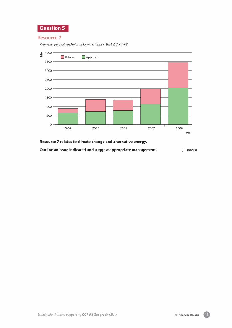
Resource 2
Plant and animal species at risk in the Nevada Desert spring communities
Resource 3
Resources 2 and 3 relate to a proposal to extract groundwater from a desert aquifer in southern Nevada.
Outline an issue indicated and suggest appropriate management. (10 marks)
Explosive economic and population growth in Las Vegas, Nevada, has stimulated demand foradditional water supplies. However, water demand in this arid environment has reached thelimits of current supply. To meet future needs, local officials from Las Vegas and satellitecommunities hope to obtain rights to about 1.32 billion m3 per year from a regionalgroundwater aquifer extending from Salt Lake City, Utah, to Death Valley, California. Thisaquifer feeds the Great Basin spring systems. These springs support unique ecosystems ofgreat biodiversity, including 20 species and sub-species — mainly snails, insects and fish —listed under the Endangered Species Act.
Source: Bioscience, September 2007, Vol. 57, No. 8.
Native spring-dwellingspecies in southern Nevada
Endangered species/sub-species
Threatened species/sub-species
Mammals 1 0
Birds 2 0
Fish 11 2
Plants 1 2
14Examination Matters, supporting OCR A2 Geography, Raw © Philip Allan Updates

Question 3
Resource 4
Track followed by Hurricane Ike across the Caribbean and Gulf of Mexico
Resource 5
The Cuban government ordered 1.2 million people to seek safety with friends and relatives orat government shelters.
In Havana, where Hurricane Ike was expected to unleash heavy winds and rain this morning,evacuations began in earnest yesterday afternoon.
The government closed schools and government offices in the capital as people reinforcedwindows, removed plants from balconies and formed long queues at bakeries.
Gustav tore across western Cuba as a Category 4 hurricane last month, damaging 100 000homes and causing billions of dollars of damage. But no deaths were reported as a result ofmandatory evacuations of at least 250 000 people.
‘In all of Cuba’s history, we have never had two hurricanes this close together,’ said JoséRubiera, head of Cuba’s meteorological service.
Waves created by Ike crashed into apartment buildings, hurling heavy spray over theirrooftops, and winds uprooted trees.
Falling utility poles crushed cars parked along narrow streets in the central city of Camagüeyand the wind transformed buildings of stone and brick into piles of rubble.
Felix García, a meteorologist at the US National Hurricane Center in Miami, forecast that Ikewould become even more powerful.
‘It’s over warm waters,’ García said. ‘It can definitely maintain its strength right now, and whenit’s out of Cuba it has the potential to become a lot stronger.’
Source: Newspaper extract from 9 September 2008
15Examination Matters, supporting OCR A2 Geography, Raw © Philip Allan Updates

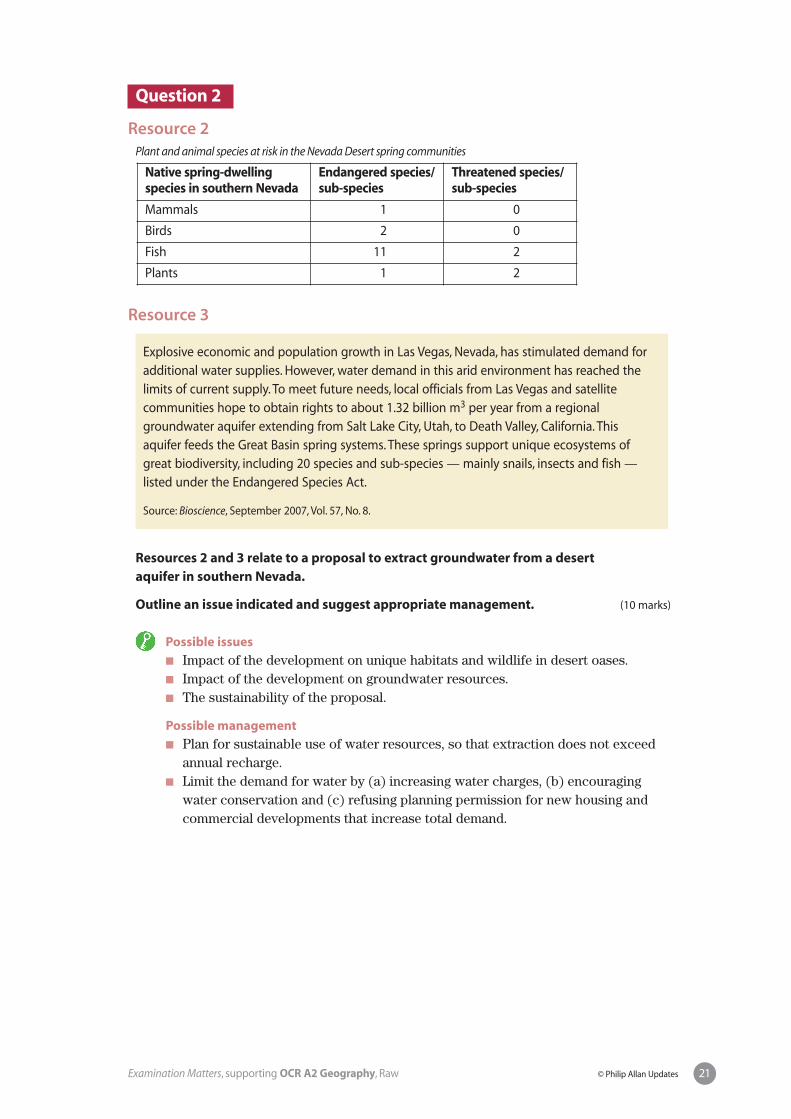
Resources 4 and 5 relate to Hurricane Ike, an Atlantic hurricane that hit the Caribbean and Texas in September 2008.
Outline an issue indicated and suggest appropriate management. (10 marks)
16Examination Matters, supporting OCR A2 Geography, Raw © Philip Allan Updates

Economic issues: questions 4–6
Question 4
Resource 6
Dependency ratios for a range of MEDC countries, 1975–2005
Resource 6 concerns the ageing of populations in MEDCs.
Outline an issue indicated and suggest appropriate management. (10 marks)
35
40
45
50
55
60
65
1975 1980 1985 1990 1995 2000 2005
Dep
end
ency
rat
io (
0–14
+ >
64/
15–6
4)
UKIrelandGermanySpainPoland
17Examination Matters, supporting OCR A2 Geography, Raw © Philip Allan Updates
Question 5
Resource 7
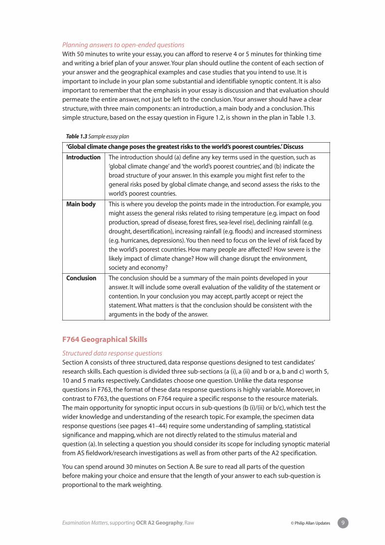
Planning approvals and refusals for wind farms in the UK, 2004–08
Resource 7 relates to climate change and alternative energy.
Outline an issue indicated and suggest appropriate management. (10 marks)
Mw
0
500
1000
1500
2000
2500
3000
3500
4000
2004
Refusal
2005 2006 2007 2008
Approval
Year
18Examination Matters, supporting OCR A2 Geography, Raw © Philip Allan Updates

Question 6
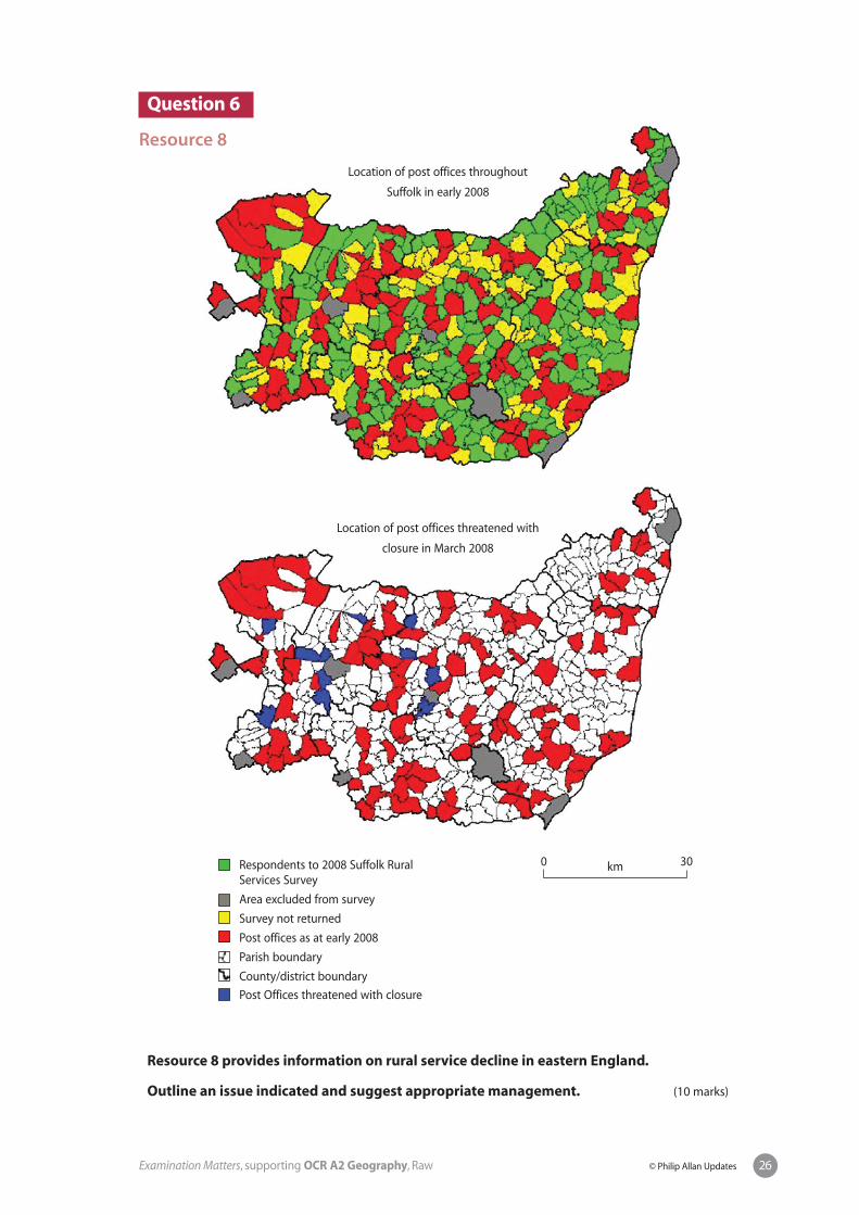
Resource 8
Location of post offices throughout
Suffolk in early 2008
Location of post offices threatened with
closure in March 2008
Resource 8 provides information on rural service decline in eastern England.
Outline an issue indicated and suggest appropriate management. (10 marks)
19Examination Matters, supporting OCR A2 Geography, Raw © Philip Allan Updates
Respondents to 2008 Suffolk RuralServices Survey
Area excluded from survey
Survey not returned
Post offices as at early 2008
Parish boundary
County/district boundary
Post Offices threatened with closure
0 30km

Section A: key content
Environmental issues: questions 1–3
Question 1
Resource 1
Resource 1 focuses on the Bhuj earthquake in Gujarat in India, in January 2001.
Outline an issue indicated and suggest appropriate management. (10 marks)
Possible issues
� As Gujarat is a zone of tectonic instability and high earthquake risk, could morehave been done to prepare the region for a major quake?
� Why was the earthquake so devastating?� Should people live in areas of known areas of risk?� What efforts were made to prepare the people, government, housing and infra-
structure for a major quake?� How effective was the relief effort in the aftermath of the quake?� Did poverty contribute to the disaster?
Possible management
� Stricter building codes (and their enforcement) to make all buildings and infra-structure earthquake-proof.
� Programmes to educate the public better about their response to earthquakes.� Disaster management plans drawn up by local authorities.� Economic development to improve living standards and reduce risks.
The 7.6 magnitude Bhuj earthquake that shook the Indian Province of Gujarat on the morningof 26 January 2001 was one of the two most deadly earthquakes to strike India in recordedhistory. One month after the earthquake official Government of India figures placed the deathtoll at 19 727 and the number of injured at 166 000. Indications were that 600 000 people wereleft homeless, with 348 000 houses destroyed and an additional 844 000 damaged. The IndianState Department estimates that the earthquake affected, directly or indirectly, 15.9 millionpeople out of a total population of 37.8 million. More than 20 000 cattle are reported killed.Government estimates place direct economic losses at $1.3 billion. Other estimates indicatelosses may be as high as $5 billion.
20Examination Matters, supporting OCR A2 Geography, Raw © Philip Allan Updates
Question 2
Resource 2
Plant and animal species at risk in the Nevada Desert spring communities
Resource 3
Resources 2 and 3 relate to a proposal to extract groundwater from a desert aquifer in southern Nevada.
Outline an issue indicated and suggest appropriate management. (10 marks)
Possible issues
� Impact of the development on unique habitats and wildlife in desert oases. � Impact of the development on groundwater resources.� The sustainability of the proposal.
Possible management
� Plan for sustainable use of water resources, so that extraction does not exceedannual recharge.
� Limit the demand for water by (a) increasing water charges, (b) encouragingwater conservation and (c) refusing planning permission for new housing andcommercial developments that increase total demand.
Explosive economic and population growth in Las Vegas, Nevada, has stimulated demand foradditional water supplies. However, water demand in this arid environment has reached thelimits of current supply. To meet future needs, local officials from Las Vegas and satellitecommunities hope to obtain rights to about 1.32 billion m3 per year from a regionalgroundwater aquifer extending from Salt Lake City, Utah, to Death Valley, California. Thisaquifer feeds the Great Basin spring systems. These springs support unique ecosystems ofgreat biodiversity, including 20 species and sub-species — mainly snails, insects and fish —listed under the Endangered Species Act.
Source: Bioscience, September 2007, Vol. 57, No. 8.
Native spring-dwellingspecies in southern Nevada
Endangered species/sub-species
Threatened species/sub-species
Mammals 1 0
Birds 2 0
Fish 11 2
Plants 1 2
21Examination Matters, supporting OCR A2 Geography, Raw © Philip Allan Updates

Question 3
Resource 4
Track followed by Hurricane Ike across the Caribbean and Gulf of Mexico
Resource 5
The Cuban government ordered 1.2 million people to seek safety with friends and relatives orat government shelters.
In Havana, where Hurricane Ike was expected to unleash heavy winds and rain this morning,evacuations began in earnest yesterday afternoon.
The government closed schools and government offices in the capital as people reinforcedwindows, removed plants from balconies and formed long queues at bakeries.
Gustav tore across western Cuba as a Category 4 hurricane last month, damaging 100 000homes and causing billions of dollars of damage. But no deaths were reported as a result ofmandatory evacuations of at least 250 000 people.
‘In all of Cuba’s history, we have never had two hurricanes this close together,’ said JoséRubiera, head of Cuba’s meteorological service.
Waves created by Ike crashed into apartment buildings, hurling heavy spray over theirrooftops, and winds uprooted trees.
Falling utility poles crushed cars parked along narrow streets in the central city of Camagüeyand the wind transformed buildings of stone and brick into piles of rubble.
Felix García, a meteorologist at the US National Hurricane Center in Miami, forecast that Ikewould become even more powerful.
‘It’s over warm waters,’ García said. ‘It can definitely maintain its strength right now, and whenit’s out of Cuba it has the potential to become a lot stronger.’
Source: Newspaper extract from 9 September 2008
22Examination Matters, supporting OCR A2 Geography, Raw © Philip Allan Updates
Resources 4 and 5 relate to Hurricane Ike, an Atlantic hurricane that hit theCaribbean and Texas in September 2008.
Outline an issue indicated and suggest appropriate management. (10 marks)
Possible issues
� Were people living in the Caribbean given sufficient early warning of thehurricane?
� Should evacuation be compulsory for populations in the coastal areas the Gulf?� Should future building be restricted in coastal areas vulnerable to storm surges?� Are flood defences adequate to cope with a category 4 or 5 hurricane?� Are poorer people and older people more vulnerable to hurricane hazards than the
rest of the population?
Possible management
� Improvements in hurricane warnings to inform the populations at risk.� Effective disaster planning to deal with emergency situations (both evacuation
and aftermath at local and national levels).� Disaster prevention measures such as flood control engineering.� Integrated ecological approaches to reduce the impact of storm surges (e.g.
maintaining wetlands, salt marshes etc.).� Planning controls on building in flood-prone coastal regions.
23Examination Matters, supporting OCR A2 Geography, Raw © Philip Allan Updates

24Examination Matters, supporting OCR A2 Geography, Raw © Philip Allan Updates
Economic issues: questions 4–6
Question 4
Resource 6
Dependency ratios for a range of MEDC countries, 1975–2005
Resource 6 concerns the ageing of populations in MEDCs.
Outline an issue indicated and suggest appropriate management. (10 marks)
Possible issues
� Increased levels of dependency with the retired population supported by adecreasing percentage of economically active persons.
� Increasing cost to government of state pensions.� Increasing cost to government of health care for ageing populations.� Declining birth rates with increasing proportion of old people.� Less vitality, drive and dynamism within society.� Social problems with more single-person households.
Possible management
� Raise the age of retirement (old people work and pay taxes for longer, don’t drawpension benefits and some die before reaching pensionable age).
� Encourage immigration of young, skilled migrants.� Legislate to make contributions to private pensions by workers compulsory.
35
40
45
50
55
60
65
1975 1980 1985 1990 1995 2000 2005
Dep
end
ency
rat
io (
0–14
+ >
64/
15–6
4)
UKIrelandGermanySpainPoland

Question 5
Resource 7
Planning approvals and refusals for wind farms in the UK, 2004–08
Resource 7 relates to climate change and alternative energy.
Outline an issue indicated and suggest appropriate management. (10 marks)
Possible issues
� The production of electricity from fossil fuels is cheaper than alternative energysuch as wind power.
� Increased use of alternative energy will create significant environmental problems.� There is widespread and popular opposition to the expansion of wind power.� Alternative energy can only meet a relatively small proportion of total energy
demand.
Possible management
� Carbon dioxide emissions could be reduced by the introduction of clean technolo-gies for coal burning, the sequestration of carbon, carbon trading etc.
� Wind farms can be sited offshore where they are less environmentally damagingand arouse less opposition.
� A range of alternative energy resources (in addition to wind power) could bedeveloped (e.g. wave energy, solar power).
Mw
0
500
1000
1500
2000
2500
3000
3500
4000
2004
Refusal
2005 2006 2007 2008
Approval
Year
25Examination Matters, supporting OCR A2 Geography, Raw © Philip Allan Updates
Respondents to 2008 Suffolk RuralServices Survey
Area excluded from survey
Survey not returned
Post offices as at early 2008
Parish boundary
County/district boundary
Post Offices threatened with closure
26Examination Matters, supporting OCR A2 Geography, Raw © Philip Allan Updates
Question 6
Resource 8
Location of post offices throughout
Suffolk in early 2008
Location of post offices threatened with
closure in March 2008
Resource 8 provides information on rural service decline in eastern England.
Outline an issue indicated and suggest appropriate management. (10 marks)
0 30km

27Examination Matters, supporting OCR A2 Geography, Raw © Philip Allan Updates
Possible issues
� Closure of rural post offices causes particular hardship for somedemographic/social/economic groups, e.g. aged, carless, poor.
� Closure increases economic and social deprivation in the countryside.� Rural services are essential to the economic health and sustainability of rural
communities.� The loss of rural services means more journeys, which contribute to congestion
and pollution and are inconsistent with sustainable planning.
Possible management
� Government subsidies to maintain rural services.� The introduction of mobile services.� Local communities cooperate and develop their own non-profit-making
enterprises (e.g. retail, transport).

Section B: essay questions and mark schemesSection B of F763 comprises twelve essay questions. These questions are split evenly betweenEnvironmental issues and Economic issues. There are two questions on each of the six topicscovered by the unit. Candidates must answer two essay questions, one from Environmentalissues and one from Economic issues. Apart from differences in content, all the essay questionsmake the same basic demands and rely on a standard generic mark scheme. The questions arebroad-based and invite discussion and evaluation within the framework of a synopticapproach. Synopticity is achieved by drawing widely on knowledge, understanding and skillsfrom other parts of the AS/A2 course and integrating them into the answer.
Environmental issues: Earth hazards
Question 1To what extent can preparedness and disaster planning mitigate the effectsof earth hazards? (30 marks)
Preparedness includes building codes in earthquake-prone regions, flood controlstructures, warnings of potential hazards by government agencies (e.g. volcaniceruptions, mass movements), disaster planning (e.g. evacuation, emergency relief).The effect of these measures is to decrease the vulnerability of a population tonatural hazards. Despite these measures, earth hazards can still result in major lossof life and economic damage. This is because other factors influence their impact,e.g. magnitude of the event, speed of the event, distribution and density of thepopulation, levels of economic development and so on.
AO1 Knowledge and understanding
Level 3 8–9 marks Detailed knowledge and understanding of the influence of preparedness andother factors for a variety of earth hazards. Cause and effect are wellunderstood and there is effective use of detailed examples.
Level 2 5–7 marks Some knowledge and understanding of the influence of preparedness andother factors for a variety of earth hazards. Cause and effect are understoodand there is use of exemplification.
Level 1 1–4 marks Limited knowledge and understanding of the influence of preparedness andother factors on earth hazards. Cause and effect are not well understood andthere is limited exemplification.
AO2 Analysis, interpretation and evaluation
Level 3 14–17 marks Clear analysis of the relative importance of preparedness etc. and an effectiveevaluation of the significance of scale, population, technology etc. Effectivesynopticity.
Level 2 8–13 marks Some analysis of the relative importance of preparedness etc. and a limitedevaluation of the significance of other factors. Some attempt at synopticity.
Level 1 1–7 marks Limited analysis of the relative importance of preparedness etc. and noattempt to evaluate the significance of other factors.
28Examination Matters, supporting OCR A2 Geography, Raw © Philip Allan Updates
AO3 Investigate, conclude, communicate
Level 3 4 marks Answer is well structured with effective use of grammar and spelling.Geographical terminology is used accurately.There is a clear conclusion.
Level 2 3 marks Answer may have poor structure with some inaccurate spelling andinaccurate use of geographical terminology.There is a limited conclusion.
Level 1 1–2 marks Communication is basic, with little structure and inaccurate spelling.There isno attempt at a conclusion.
e You will need to define the terms ‘preparedness’ and ‘disaster planning’ at the outset.Good answers will recognise that the impact/effect of earth hazards is due to a range offactors (scale of the event, population density etc.) and that preparedness can only do somuch. Effective preparedness greatly reduced the death toll in earthquakes in SanFrancisco (1989) and Northridge (1994) but this was not the case in Kobe in 1995. Theargument that poor countries are harder hit by earth hazards than rich countries (e.g.Nevado del Ruiz eruption of 1985, Asian tsunami 2004) is persuasive. Arguments shouldbe balanced and draw on a number of different earth hazards. Use should be made of ASstudies on population distribution, urban population density and levels of developmentto provide a synoptic input. The essay should end with a clear conclusion that isconsistent with previous arguments.
29Examination Matters, supporting OCR A2 Geography, Raw © Philip Allan Updates

Environmental issues: Ecosystems and environments under threat
Question 2Discuss the view that humankind’s current exploitation of natural ecosystems is unsustainable. (30 marks)
Evidence to support the statement will be cited from specific examples at a range ofscales, e.g. global warming and climate change, desertification, land degradation,deforestation, overfishing, falling water tables etc. However, candidates can counterthe statement with examples of sustainable management of ecosystems, e.g. nationalparks, nature reserves, forestry, stewardship in modern farming etc.
AO1 Knowledge and understanding
Level 3 8–9 marks Detailed knowledge and understanding of sustainable and unsustainable useof natural ecosystems. Cause and effect are well understood and there iseffective use of detailed examples.
Level 2 5–7 marks Some knowledge and understanding of the sustainable and unsustainableuse of natural ecosystems. Cause and effect are understood and there is useof exemplification.
Level 1 1–4 marks Limited knowledge and understanding of sustainable and unsustainable useof natural ecosystems. Cause and effect are not well understood and there islimited exemplification.
AO2 Analysis, interpretation and evaluation
Level 3 14–17 marks Clear analysis of the scale and significance of unsustainable use of naturalecosystems and effective evaluation of its significance compared withsustainable use. Effective synopticity.
Level 2 8–13 marks Some analysis of unsustainable use of natural ecosystems and limitedevaluation of its significance compared with sustainable use. Some attemptat synopticity.
Level 1 1–7 marks Limited analysis of unsustainable use of natural ecosystems and no attemptto evaluate its significance.
AO3 Investigate, conclude, communicate
Level 3 4 marks Answer is well structured with effective use of grammar and spelling.Geographical terminology is used accurately.There is a clear conclusion.
Level 2 3 marks Answer may have poor structure with some inaccurate spelling andinaccurate use of geographical terminology.There is a limited conclusion.
Level 1 1–2 marks Communication is basic, with little structure and inaccurate spelling.There isno attempt at a conclusion.
30Examination Matters, supporting OCR A2 Geography, Raw © Philip Allan Updates

e In general terms the statement is probably valid, but in detail it can be challenged. Theconcept of ‘sustainability’ will be central in good answers (i.e. meeting the needs of thepresent without compromising the needs of future generations) and should be definedin the introduction. Arguments must be supported by a range of specific examplesrelated to human activities such as energy extraction/production, manufacturing,tourism, farming and so on and their harmful impact on ecosystems. Case studies fromAS will be relevant (e.g. oil production in Alaska, mass tourism in Spain, ecotourism inNepal) and will provide the necessary synopticity. Examples of sustainable human use ofecosystems will provide balance to the discussion. The essay should have a reasonedconclusion, which on the whole, is more likely to go along with the assertion.
31Examination Matters, supporting OCR A2 Geography, Raw © Philip Allan Updates
Environmental issues: Climatic hazards
Question 3‘Global climate change poses the greatest risks to the world’s poorest countries’. Discuss. (30 marks)
Candidates will need to identify the ‘risks’ that include: rising sea level; increasedstorminess, hurricanes, drought, heat waves and rainfall in some regions; spread ofdisease/pests; loss of habitat etc. The world’s poorest countries lack the economicresources to protect against the worst effects of climate change. This contentionshould be supported by specific examples such as Bangladesh (tropical cyclones,sea-level rise), desertification in sub-Saharan Africa, water supplies in countriesdependent on Himalayan glaciers etc. An alternative view is that climate change alsoaffects MEDCs. For instance, southern Spain and the US mid-west may become toodry for crop farming, coastal defences may be abandoned in the face of rising sealevel and increased storminess etc. While MEDCs also face great risks, the likelyconclusion is that these are less than in the world’s poorest countries.
AO1 Knowledge and understanding
Level 3 8–9 marks Detailed knowledge and understanding of the risks posed by climate changeand their likely impact. Cause and effect are well understood and there iseffective use of detailed examples.
Level 2 5–7 marks Some knowledge and understanding of the risks posed by climate changeand their likely impact. Cause and effect are understood and there is use ofexemplification.
Level 1 1–4 marks Limited knowledge and understanding of the risks posed by climate changeand their likely impact. Cause and effect are not well understood and there islimited exemplification.
AO2 Analysis, interpretation and evaluation
Level 3 14–17 marks Clear analysis of the impact of climate change and effective evaluation of itsrelative significance in LEDCs and MEDCs. Effective synopticity.
Level 2 8–13 marks Some analysis of the impact of climate change and limited evaluation of itsrelative significance in LEDCs and MEDCs. Some attempt at synopticity.
Level 1 1–7 marks Limited analysis of the impact of climate change and no attempt to evaluateits significance.
AO3 Investigate, conclude, communicate
Level 3 4 marks Answer is well structured with effective use of grammar and spelling.Geographical terminology is used accurately.There is a clear conclusion.
Level 2 3 marks Answer may have poor structure with some inaccurate spelling andinaccurate use of geographical terminology.There is a limited conclusion.
Level 1 1–2 marks Communication is basic, with little structure and inaccurate spelling.There isno attempt at a conclusion.
32Examination Matters, supporting OCR A2 Geography, Raw © Philip Allan Updates

e You should first define global climate change (though resist the temptation to write inany detail about its causes), then state the risks associated with climate change and finallyexplain what you understand by the term ‘the world’s poorest countries’. Arguments bothfor and against the statement must be considered and evaluation of the question shouldappear throughout the answer (not just in the conclusion). Your overall position on theissue should appear in the conclusion. The scope for synoptic input includes studies onflooding (coastal and river), coastal erosion, land degradation and desertification in aridand semi-arid environments from AS.
33Examination Matters, supporting OCR A2 Geography, Raw © Philip Allan Updates
Economic issues: Population and resources
Question 4To what extent is natural resource development and exploitation in LEDCs influenced by population growth? (30 marks)
Natural resource development depends on a range of economic, social and political,as well as demographic factors. At a national scale population growth may stimulateresource development (e.g. Brazil in Amazonia) and provide a domestic market. Theinfluence of population growth is evident at local scales where resource over-exploitation and land degradation occur. Good answers will recognise thatpopulation growth is often of minor significance. Other factors, especially economicand political, are often of far greater importance (e.g. the political influence of Chinain the Democratic Republic of Congo and the Sudan; economic requirements to cutor service international debt, promote economic and social development, boostexports and reduce imports etc.).
AO1 Knowledge and understanding
Level 3 8–9 marks Detailed knowledge and understanding of the influence of populationgrowth and other factors on resource development. Cause and effect are wellunderstood and there is effective use of detailed examples.
Level 2 5–7 marks Some knowledge and understanding of the influence of population growthand other factors on resource development. Cause and effect are understoodand there is use of exemplification.
Level 1 1–4 marks Limited knowledge and understanding of the influence of population growthand other factors on resource development. Cause and effect are not wellunderstood and there is limited exemplification.
AO2 Analysis, interpretation and evaluation
Level 3 14–17 marks Clear analysis of the role of population growth and effective evaluation of itssignificance compared with other factors. Effective synopticity.
Level 2 8–13 marks Some analysis of the role of population growth and limited evaluation of itssignificance compared with other factors. Some attempt at synopticity.
Level 1 1–7 marks Limited analysis of role of population growth and no attempt to evaluate itssignificance.
AO3 Investigate, conclude, communicate
Level 3 4 marks Answer is well structured with effective use of grammar and spelling.Geographical terminology is used accurately.There is a clear conclusion.
Level 2 3 marks Answer may have poor structure with some inaccurate spelling andinaccurate use of geographical terminology.There is a limited conclusion.
Level 1 1–2 marks Communication is basic, with little structure and inaccurate spelling.There isno attempt at a conclusion.
34Examination Matters, supporting OCR A2 Geography, Raw © Philip Allan Updates

e The key to a successful answer is finding examples where population growth has playeda major part in natural resource development and exploitation, and where its influencehas been insignificant. At a local or regional scale, over-exploitation is often linked directly(or indirectly) to population growth. AS examples, which provide synopticity, includedeforestation in the Himalayas (Nepal) and desertification in the Sahel (Mali). On theother hand, AS examples such as energy developments in Alaska, Nigeria and California,and overfishing in the North Sea have little, if any connection, to population growth.Conclusions need to be balanced, well reasoned and consistent.
35Examination Matters, supporting OCR A2 Geography, Raw © Philip Allan Updates

Economic issues: Globalisation
Question 5‘Recent globalisation has resulted in a widening of the development gap.’How far do you agree with this statement? (30 marks)
Arguments are balanced on both sides. It can be argued that globalisation hasbrought greater benefit to rich countries and TNCs than to the world’s poorestcountries, especially in Africa. The effects of free trade and trade restrictions areinstructive here. On the other hand, globalisation has created millions of jobs inLEDCs (outsourcing, offshoring) and has led to significant foreign direct investment.Emerging economies like China, India and Brazil have closed the development gapfor these countries.
AO1 Knowledge and understanding
Level 3 8–9 marks Detailed knowledge and understanding of the impact of globalisation on thedevelopment gap. Cause and effect are well understood and there is effectiveuse of detailed examples.
Level 2 5–7 marks Some knowledge and understanding of the impact of globalisation on thedevelopment gap. Cause and effect are understood and there is use ofexemplification.
Level 1 1–4 marks Limited knowledge and understanding of the impact of globalisation on thedevelopment gap. Cause and effect are not well understood and there islimited exemplification.
AO2 Analysis, interpretation and evaluation
Level 3 14–17 marks Clear analysis of globalisation and effective evaluation of its impact on thedevelopment gap. Effective synopticity.
Level 2 8–13 marks Some analysis of globalisation and limited evaluation of its impact on thedevelopment gap. Some attempt at synopticity.
Level 1 1–7 marks Limited analysis of globalisation and no attempt to evaluate its impact on thedevelopment gap.
AO3 Investigate, conclude, communicate
Level 3 4 marks Answer is well structured with effective use of grammar and spelling.Geographical terminology is used accurately.There is a clear conclusion.
Level 2 3 marks Answer may have poor structure with some inaccurate spelling andinaccurate use of geographical terminology.There is a limited conclusion.
Level 1 1–2 marks Communication is basic, with little structure and inaccurate spelling.There isno attempt at a conclusion.
36Examination Matters, supporting OCR A2 Geography, Raw © Philip Allan Updates

e The question demands a definition of globalisation (e.g. integration of the worldeconomy, increasing flows of goods, services, capital, people etc. between countries) andthe development gap (economic differences between rich and poor countries). Answersshould aim to be discursive and evaluative throughout. Arguments supporting anddisagreeing with the statement should be presented, and illustrated with detailedexamples. Although the ‘development gap’ usually refers to international differences ineconomic well being, there is scope for synoptic input by referring to regionaldifferences in wealth within countries that result from developments in tourism andenergy sponsored by TNCs. A valid conclusion might be to argue that the validity of thestatement depends on the scale of analysis.
37Examination Matters, supporting OCR A2 Geography, Raw © Philip Allan Updates

Economic issues: Development and inequalities
Question 6Assess the contribution of physical factors to global inequalities in development. (30 marks)
Physical factors will include natural resources and relative location (i.e. accessi-bility). Some of the world’s poorest countries are isolated and landlocked (e.g. in sub-Saharan Africa) and some have few natural resources (e.g. Haiti, Ethiopia). Othersare predominantly arid or semi-arid (e.g. Chad, Somalia). In the humid tropics, theprevalence of disease may contribute to inequality. However, many economic, social,demographic, historical and political factors contribute to inequalities. Manysuccessful MEDCs have few natural resources, e.g. Japan, Netherlands. The influenceof human resources (skills and education of the workforce) is crucial in explainingglobal inequalities.
AO1 Knowledge and understanding
Level 3 8–9 marks Detailed knowledge and understanding of the significance of physical, andother factors in explaining global inequalities. Cause and effect are wellunderstood and there is effective use of detailed examples.
Level 2 5–7 marks Some knowledge and understanding of the significance of physical andother factors in explaining global inequalities. Cause and effect areunderstood and there is use of exemplification.
Level 1 1–4 marks Limited knowledge and understanding of the significance of physical, andother factors in explaining global inequalities. Cause and effect are not wellunderstood and there is limited exemplification.
AO2 Analysis, interpretation and evaluation
Level 3 14–17 marks Clear analysis of the factors responsible for global inequalities, and effectiveevaluation of the relative importance of physical factors. Effective synopticity.
Level 2 8–13 marks Some analysis of the factors responsible for global inequalities, and limitedevaluation of the relative importance of physical factors. Some attempt atsynopticity.
Level 1 1–7 marks Limited analysis of the factors responsible for global inequalities, and noattempt to evaluate the relative importance of physical factors.
AO3 Investigate, conclude, communicate
Level 3 4 marks Answer is well structured with effective use of grammar and spelling.Geographical terminology is used accurately.There is a clear conclusion.
Level 2 3 marks Answer may have poor structure with some inaccurate spelling andinaccurate use of geographical terminology.There is a limited conclusion.
Level 1 1–2 marks Communication is basic, with little structure and inaccurate spelling.There isno attempt at a conclusion.
38Examination Matters, supporting OCR A2 Geography, Raw © Philip Allan Updates

e You need to be clear what is meant by the term ‘physical factors’, and so the first task isone of definition. It might be useful to list all the factors that make significantcontributions to global inequality. Specific examples are needed to support thecontention that physical factors have a significant influence, particularly in extremeenvironments. AS studies of drought and of mountain environments will provide somesynopticity.While a range of other factors influence global inequalities (economic, social,political etc.) and should be explained, the focus and emphasis must be on physicalfactors. An approach that simply goes through all of the factors that cause globalinequalities, and is largely descriptive, will not provide a satisfactory and relevant answer.Evaluation should figure prominently throughout the answer, and should not be reservedfor the conclusion.
39Examination Matters, supporting OCR A2 Geography, Raw © Philip Allan Updates

40Examination Matters, supporting OCR A2 Geography, Raw © Philip Allan Updates
Unit F764 Geographical Skills
Questions and mark schemesThe Geographical Skills paper is divided into two sections. Section A comprises three structuredquestions, each divided into three parts and worth a total of 20 marks. These questions aresupported by data, in the form of tables, charts, maps and photographs, and test general under-standing of geographical research skills. Candidates answer one question from Section A.Section B consists of two essay questions centred on a candidate’s personal fieldworkexperience. Candidates must answer both questions.

Section A: structured questions
Geographical research: questions 1–3
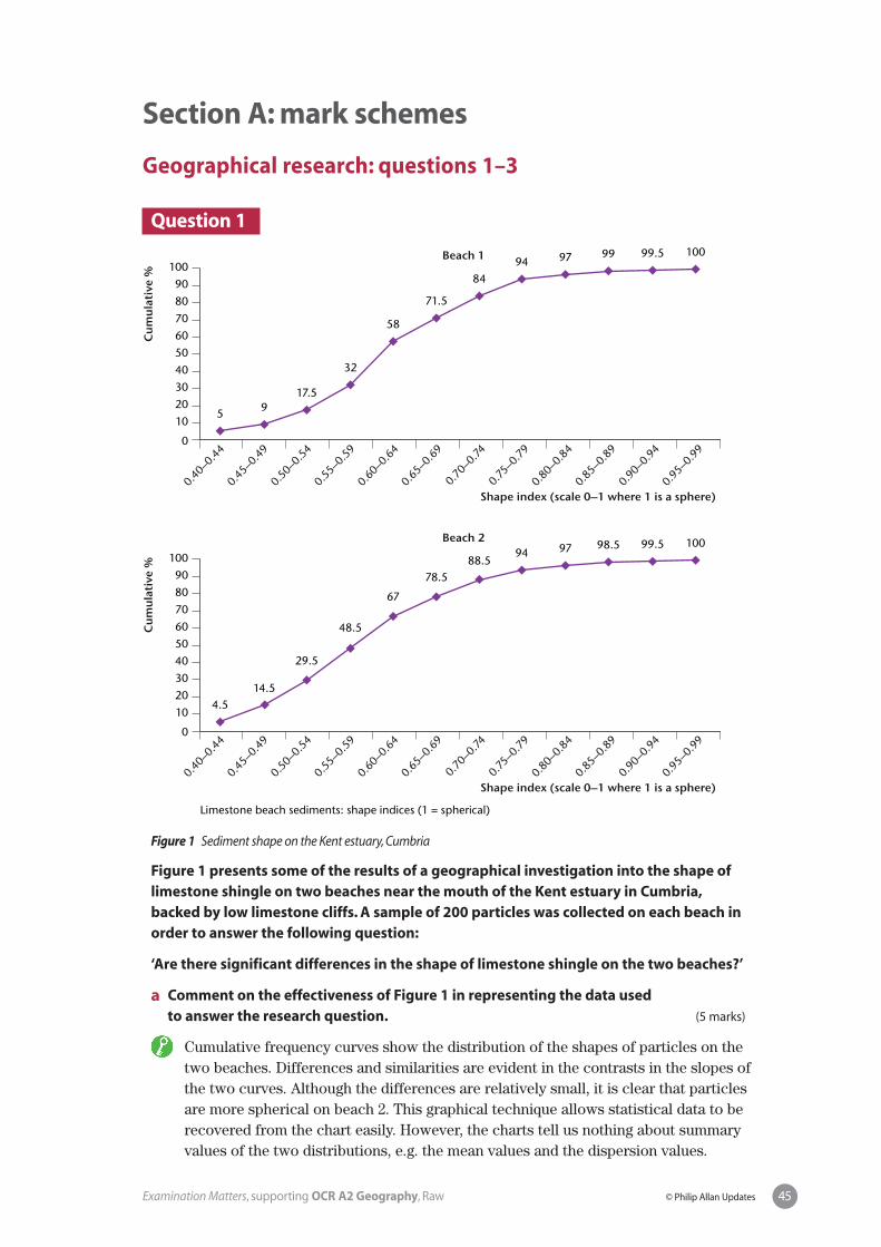
Question 1
Figure 1 Sediment shape on the Kent estuary, Cumbria
Figure 1 presents some of the results of a geographical investigation into the shape oflimestone shingle on two beaches near the mouth of the Kent estuary in Cumbria,backed by low limestone cliffs. A sample of 200 particles was collected on each beach inorder to answer the following question:
‘Are there significant differences in the shape of limestone shingle on the two beaches?’
a Comment on the effectiveness of Figure 1 in representing the data used to answer the research question. (5 marks)
b Describe and explain one relevant statistical technique that could be used to analyse differences in particle shape between the two beaches. (10 marks)
c Suggest possible reasons why fieldwork and/or research investigations often fail to show the results you expected. (5 marks)
Cu
mu
lati
ve %
Shape index (scale 0–1 where 1 is a sphere)
Shape index (scale 0–1 where 1 is a sphere)
0
1020304050
7060
100
8090
0.40–0.4
40.4
5–0.49
0.50–0.5
40.5
5–0.59
0.60–0.6
40.6
5–0.69
0.70–0.74
0.75–0.7
90.8
0–0.84
0.85–0.8
90.9
0–0.94
0.95–0.9
9
Cu
mu
lati
ve %
0
1020304050
7060
100
8090
0.40–0.4
40.4
5–0.49
0.50–0.5
40.5
5–0.59
0.60–0.6
40.6
5–0.69
0.70–0.74
0.75–0.7
90.8
0–0.84
0.85–0.8
90.9
0–0.94
0.95–0.9
9
5 917.5
32
58
71.5
8494 97 99 99.5 100
4.5
Limestone beach sediments: shape indices (1 = spherical)
14.5
29.5
48.5
67
78.588.5
94 97 98.5 99.5 100
Beach 1
Beach 2
41Examination Matters, supporting OCR A2 Geography, Raw © Philip Allan Updates
Question 2
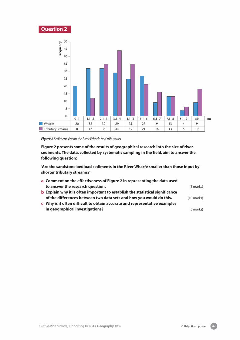
Figure 2 Sediment size on the River Wharfe and tributaries
Figure 2 presents some of the results of geographical research into the size of riversediments. The data, collected by systematic sampling in the field, aim to answer thefollowing question:
‘Are the sandstone bedload sediments in the River Wharfe smaller than those input byshorter tributary streams?’
a Comment on the effectiveness of Figure 2 in representing the data used to answer the research question. (5 marks)
b Explain why it is often important to establish the statistical significance of the differences between two data sets and how you would do this. (10 marks)
c Why is it often difficult to obtain accurate and representative examples in geographical investigations? (5 marks)
42Examination Matters, supporting OCR A2 Geography, Raw © Philip Allan Updates
Freq
uen
cy
cm0
5
10
15
20
25
35
30
50
40
45
0–1 1.1–2 2.1–3 3.1–4 4.1–5 5.1–6 6.1–7 7.1–8 8.1–9 ≥9
20 32 32 29 25 27 9 13 4 9
0
Wharfe
Tributary streams 12 35 44 35 21 16 13 6 19
Question 3
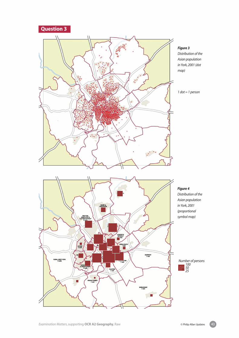
Figure 3
Distribution of the
Asian population
in York, 2001 (dot
map)
1 dot = 1 person
Figure 4
Distribution of the
Asian population
in York, 2001
(proportional
symbol map)
43Examination Matters, supporting OCR A2 Geography, Raw © Philip Allan Updates
Number of persons1005025

Figures 3 and 4 show the distribution of the Asian population in York by ward in 2001.They formed part of an investigation into the city’s ethnic geography, which aimed toanswer the following question:
‘How segregated is the Asian population within the city of York?’
a Outline the methods you would use to construct either a dot map (Figure 3) or a proportional symbol map (Figure 4). (5 marks)
b Compare the effectiveness of the maps in Figures 3 and 4 for representing spatial distributions in geography. (10 marks)
c Outline an alternative technique you could use to represent the data shown in Figures 3 and 4. (5 marks)
44Examination Matters, supporting OCR A2 Geography, Raw © Philip Allan Updates
Section A: mark schemes
Geographical research: questions 1–3
Question 1
Figure 1 Sediment shape on the Kent estuary, Cumbria
Figure 1 presents some of the results of a geographical investigation into the shape oflimestone shingle on two beaches near the mouth of the Kent estuary in Cumbria,backed by low limestone cliffs. A sample of 200 particles was collected on each beach inorder to answer the following question:
‘Are there significant differences in the shape of limestone shingle on the two beaches?’
a Comment on the effectiveness of Figure 1 in representing the data used to answer the research question. (5 marks)
Cumulative frequency curves show the distribution of the shapes of particles on thetwo beaches. Differences and similarities are evident in the contrasts in the slopes ofthe two curves. Although the differences are relatively small, it is clear that particlesare more spherical on beach 2. This graphical technique allows statistical data to berecovered from the chart easily. However, the charts tell us nothing about summaryvalues of the two distributions, e.g. the mean values and the dispersion values.
Cu
mu
lati
ve %
Shape index (scale 0–1 where 1 is a sphere)
Shape index (scale 0–1 where 1 is a sphere)
0
1020304050
7060
100
8090
0.40–0.4
40.4
5–0.49
0.50–0.5
40.5
5–0.59
0.60–0.6
40.6
5–0.69
0.70–0.74
0.75–0.7
90.8
0–0.84
0.85–0.8
90.9
0–0.94
0.95–0.9
9
Cu
mu
lati
ve %
0
1020304050
7060
100
8090
0.40–0.4
40.4
5–0.49
0.50–0.5
40.5
5–0.59
0.60–0.6
40.6
5–0.69
0.70–0.74
0.75–0.7
90.8
0–0.84
0.85–0.8
90.9
0–0.94
0.95–0.9
9
5 917.5
32
58
71.5
8494 97 99 99.5 100
4.5
Limestone beach sediments: shape indices (1 = spherical)
14.5
29.5
48.5
67
78.588.5
94 97 98.5 99.5 100
Beach 1
Beach 2
45Examination Matters, supporting OCR A2 Geography, Raw © Philip Allan Updates

Level Mark Descriptor
Level 2 4–5 marks Candidates comment clearly on Figure 1 and give a range of advantages andlimitations well linked to the question. Specific references are made to Figure 1.
Level 1 0–3 marks Candidates provide only limited comments on Figure 1 with few advantagesand disadvantages, and with little, if any, linkage to the question or Figure 1.
b Describe and explain one relevant statistical technique that could be used to analyse differences in particle shape between the two beaches. (10 marks)
Chi-squared is the appropriate inferential statistical test that compares thedifferences between two frequency distributions. It is based on absolute values sothe values in Figure 1 would have to be converted from percentages. The bigger thevalue of Chi-squared the greater the probability that the differences are not due tochance. An alternative (but less analytical) technique would involve calculating themeans, standard deviations and coefficient of variations for the two data sets.
Level Mark Descriptor
Level 3 8–10 marks Candidates describe a relevant statistical technique clearly and accurately.They explain clearly why the technique is appropriate and what its shows.
Level 2 5–7 marks Candidates describe a relevant statistical technique with limited detail andaccuracy.There is some explanation of the appropriateness of the technique.Alternatively, candidates may describe a technique that is only partlyappropriate, but provide a reasoned explanation of its use.
Level 1 0–4 marks Candidates may describe a technique that is only partly appropriate and areunable to provide a reasoned explanation for its use.
c Suggest possible reasons why fieldwork and/or research investigations often fail to show the results you expected. (5 marks)
Among possible reasons are problems with methodology and the complex, multi-variate nature of the real world. Typical methodological problems include inadequatesample size, unrepresentative samples, inaccurate measurement, inappropriate scalesand so on. Many investigations of relationships often assume that y is influenced byx, when in reality y may be influenced by x1, x2, x3, x
n. Candidates can draw on their
experience of fieldwork/research at both AS and A2 to achieve synoptic input.
Level Mark Descriptor
Level 2 4–5 marks Candidates provide detailed suggestions (two or more), supported byappropriate examples, and demonstrate effective synopticity.
Level 1 0–3 marks Candidates give limited suggestions (either superficial or only one in detail),with little evidence of synopticity.
46Examination Matters, supporting OCR A2 Geography, Raw © Philip Allan Updates
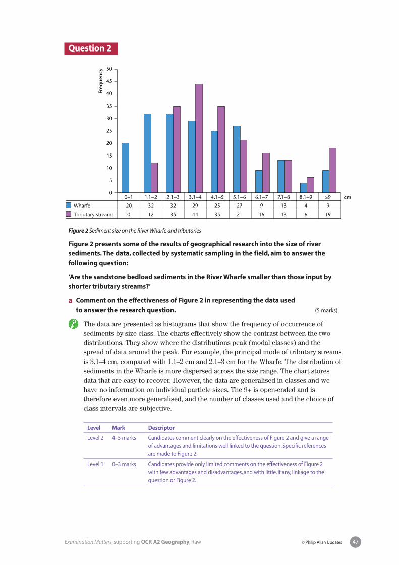
Question 2
Figure 2 Sediment size on the River Wharfe and tributaries
Figure 2 presents some of the results of geographical research into the size of riversediments. The data, collected by systematic sampling in the field, aim to answer thefollowing question:
‘Are the sandstone bedload sediments in the River Wharfe smaller than those input byshorter tributary streams?’
a Comment on the effectiveness of Figure 2 in representing the data used to answer the research question. (5 marks)
The data are presented as histograms that show the frequency of occurrence ofsediments by size class. The charts effectively show the contrast between the twodistributions. They show where the distributions peak (modal classes) and thespread of data around the peak. For example, the principal mode of tributary streamsis 3.1–4 cm, compared with 1.1–2 cm and 2.1–3 cm for the Wharfe. The distribution ofsediments in the Wharfe is more dispersed across the size range. The chart storesdata that are easy to recover. However, the data are generalised in classes and wehave no information on individual particle sizes. The 9+ is open-ended and istherefore even more generalised, and the number of classes used and the choice ofclass intervals are subjective.
Level Mark Descriptor
Level 2 4–5 marks Candidates comment clearly on the effectiveness of Figure 2 and give a rangeof advantages and limitations well linked to the question. Specific referencesare made to Figure 2.
Level 1 0–3 marks Candidates provide only limited comments on the effectiveness of Figure 2with few advantages and disadvantages, and with little, if any, linkage to thequestion or Figure 2.
47Examination Matters, supporting OCR A2 Geography, Raw © Philip Allan Updates
Freq
uen
cy
cm0
5
10
15
20
25
35
30
50
40
45
0–1 1.1–2 2.1–3 3.1–4 4.1–5 5.1–6 6.1–7 7.1–8 8.1–9 ≥9
20 32 32 29 25 27 9 13 4 9
0
Wharfe
Tributary streams 12 35 44 35 21 16 13 6 19
b Explain why it is often important to establish the statistical significance of the differences between two data sets and describe how you would do this. (10 marks)
Investigations often compare the differences between two sample data sets (as inFigure 2). Although the samples should have been collected objectively and scientifi-cally, there is, nonetheless, a possibility that any differences could be due to chance.Statistical analysis tells us the probability of this happening. Normally, if thedifferences have just a 5% or less probability of occurring by chance, we accept themas statistically significant. Three statistical tests are available to analyse thedifferences between samples: t-test, U-test and chi-squared. In this question adescription of one test would be sufficient. The t-test can only be used where dataare available on a ratio scale; the U-test is based on ordinal (i.e. ranked) data; andchi-squared analyses the differences between frequency distributions (two in thiscase). Some reference to how you would use statistical tables to determine thesignificance of differences should be included.
Level Mark Descriptor
Level 3 8–10 marks Candidates explain the need to establish statistical significance and describea relevant statistical technique, clearly and accurately.
Level 2 5–7 marks Candidates explain the need to establish statistical significance and describea relevant statistical technique, with some detail and accuracy. Alternatively,candidates may describe accurately a technique that is only partlyappropriate, and how they would use it.
Level 1 0–4 marks Candidates provide a limited explanation of statistical significance anddescribe a statistical technique that is only partly appropriate.They areunable to say how they would use it.
c Why is it often difficult to obtain accurate and representative samples in geographical investigations? (5 marks)
The best way to approach this is to focus on actual examples. In physical geographypopulations are often not distributed randomly. For example, sediments in riverchannels may have variable sorting along some reaches. This makes it very difficultto achieve a truly representative sample. Often in human geography, the lack of anysample frame (i.e. documents with a listing of the population) makes achieving arepresentative sample almost impossible. For example, the problem of stratifyingsamples of shoppers interviewed in a shopping centre (e.g. what proportion shouldbe males/females, high/medium/low income, young/middle aged/old etc.?). Furtherproblems of accuracy and representativeness occur when respondents, selected forinterview either randomly or systematically, decline to be interviewed. Synoptic inputwill draw on fieldwork/research investigations completed during AS and A2 studies.
Level Mark Descriptor
Level 2 4–5 marks Candidates provide detailed suggestions (two or more), supported byappropriate examples, and demonstrate effective synopticity.
Level 1 0–3 marks Candidates give limited suggestions (either superficial or only one in detail),with little evidence of synopticity.
48Examination Matters, supporting OCR A2 Geography, Raw © Philip Allan Updates

Question 3
Figure 3
Distribution of the
Asian population
in York, 2001 (dot
map)
1 dot = 1 person
Figure 4
Distribution of the
Asian population
in York, 2001
(proportional
symbol map)
49Examination Matters, supporting OCR A2 Geography, Raw © Philip Allan Updates
Number of persons1005025

Figures 3 and 4 show the distribution of the Asian population in York by ward in 2001.They formed part of an investigation into the city’s ethnic geography, which aimed toanswer the following question:
‘How segregated is the Asian population within the city of York?’
a Outline the methods you would use to construct either a dot map (Figure 3) or a proportional symbol map (Figure 4). (5 marks)
Both maps require a base map that shows the statistical areas for which data areavailable. Before constructing dot maps, decisions are needed on the size of dot, thevalue of each dot, and placement within statistical areas. A map showing the distribu-tion of built areas is required for accurate placement of the dots. With proportionalsymbol maps decisions have to be made on the type of symbol used (circles orsquares usually), their scale in relation to the map and their placement within thestatistical areas.
Level Mark Descriptor
Level 2 4–5 marks Candidates outline clearly and accurately all the steps involved in theconstruction of their chosen map.
Level 1 0–3 marks Candidates provide only a limited outline of the steps involved, or a moredetailed outline of just one or two of the steps.
b Compare the effectiveness of the maps in Figures 3 and 4 for representing spatial distributions in geography. (10 marks)
The criteria that could be used to compare the effectiveness of the maps include:accuracy, level of detail/generalisation, visual impact, recovery of statistical datafrom the map, ease of interpretation etc. Proportional symbol maps are moregeneralised and show less detail. Overcrowding of symbols in central areas of thecity may compromise the visual impact and interpretation. Moreover, because thearea of symbols is proportional to values, interpretation can be difficult. Dot mapsgive a misleading impression of accuracy (placement involves a large degree ofsubjectivity). Recovering data in areas of highest density is also problematic.
Level Mark Descriptor
Level 3 8–10 marks Candidates compare the two maps clearly and accurately using a good rangeof criteria, and support their answers with specific references to Figures 3and 4.
Level 2 5–7 marks Candidates provide a sound comparison of two maps, either across a limitedrange of criteria or with limited depth. Answers are fairly generalised but withsome reference to Figures 3 and 4.
Level 1 0–4 marks Candidates provide some comparison of the two maps, but with little detailand against few relevant criteria. Answers make few, if any, references toFigures 3 and 4.
50Examination Matters, supporting OCR A2 Geography, Raw © Philip Allan Updates

c Outline an alternative technique you could use to represent the data shown in Figures 3 and 4. (5 marks)
The most obvious mapping technique is choropleth mapping. Effective outlines ofthis technique would refer to the size and shape of statistical units, number ofclasses, class intervals, shading and so on. Isopleth maps, although more generalisedand more difficult to draw, would also be an appropriate alternative. Candidatescould opt for non-mapping statistical techniques such as Lorenz curves and the Ginicoefficient, and dissimilarity (segregation) indexes. The technique chosen could bedrawn specifically from topics across a range of human geography options at AS andA2. This would provide evidence of synopticity.
Level Mark Descriptor
Level 2 4–5 marks Candidates provide detailed suggestions (two or more) of appropriate factorsthat demonstrate clear synopticity.
Level 1 0–3 marks Candidates give limited suggestions (either superficial or only one in detail),with little evidence of synopticity.
51Examination Matters, supporting OCR A2 Geography, Raw © Philip Allan Updates

Section B: essay questions
Geographical investigations: questions 4 and 5
Question 4Using your fieldwork and research experience at A-level, describe the use you made of sampling methods in data collection and assess their value. (20 marks)
52Examination Matters, supporting OCR A2 Geography, Raw © Philip Allan Updates

Question 5State the nature of an investigation (fieldwork/research) conducted during your A-level studies. Describe the analytical techniques used in your investigation, justify your choice, and assess their usefulness. (20 marks)
53Examination Matters, supporting OCR A2 Geography, Raw © Philip Allan Updates

Section B: mark schemes
Geographical investigations: questions 4 and 5
Question 4Using your fieldwork and research experience at A-level, describe the use you made of sampling methods in data collection and assess their value. (20 marks)
The description will include details of scale, sample sizes, sampling methodologiesand precautions taken to ensure that the samples accurately represented thepopulation. Assessment of the value of the samples will consider the accuracy of thesample data, the appropriateness of the sample data for statistical analysis andhypothesis testing, the representativeness of the data and the resources required tocomplete the sampling exercises. Answers should be presented within theframework of actual fieldwork investigations.
Level Mark Descriptor
Level 3 16–20 marks Most aspects of the indicative content will be covered in a fieldwork-focusedcontext. Answers will be well structured with accurate use of geographicalterminology.
Level 2 10–15 marks Sound description of some aspects of sampling methods combined withsome assessment of their value, partly related to actual fieldwork.Alternatively, descriptions may be clear and detailed but contain little or noassessment (or vice versa).There will be some valid references to fieldwork.Answers may have poor structure with some inaccurate spelling andinaccurate use of geographical terminology.
Level 1 0–9 marks Limited description of sampling methods combined with little or noassessment of their value. Answers tend to be generic rather than based onactual fieldwork across AS and A2.
54Examination Matters, supporting OCR A2 Geography, Raw © Philip Allan Updates

Question 5State the nature of an investigation (fieldwork/research) conducted during your A-level studies. Describe the analytical techniques used in your investigation, justify your choices, and assess their usefulness. (20 marks)
Introductory statements should be given about the nature of the investigation(e.g. location, aim, subject area, scale). Clear reference should be made to afieldwork/research investigation undertaken during A-level studies. Analyticaltechniques will include some or all of the following: charts, descriptive statistics,inferential statistics, spatial indices. Differentiation will largely be achieved throughthe prominence given to justification and evaluation.
Level Mark Descriptor
Level 3 16–20 marks Candidates describe and justify in detail a range of analytical techniques theyused.There is a detailed evaluation with clear and specific reference to anactual fieldwork/research investigation.The answer is well structured withaccurate grammar and spelling. Geographical terminology is used accurately.
Level 2 10–15 marks Candidates describe and justify two or more analytical techniques.There issome evaluation and some reference to an actual fieldwork/researchinvestigation.The answer may be poorly structured with some inaccuratespelling and inaccurate use of geographical terminology.
Level 1 0–9 marks Candidates offer some description of analytical techniques, but only verylimited justification and little, if any, evaluation. Answers tend to lack a well-developed link to a fieldwork/research investigation. Communication is basicwith little structure and inaccurate spelling.
55Examination Matters, supporting OCR A2 Geography, Raw © Philip Allan Updates