Embed Size (px)
Citation preview
5
33
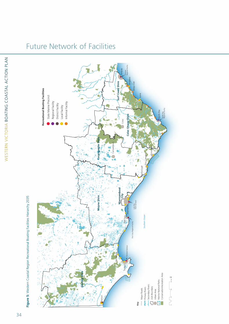
Future Network of Facilities5
• PointRoadknightAnglesea,LorneBoatRamp,PointGreylorne, Port Campbell, Princetown, Peterborough Front Beach, Curdie Vale, Boat Bay Peterborough, Killarney, Shaw River Yambuk, Allansford, Hopkins River Mahoneys, Hopkins River Upstream, Hopkins River, Merri River Dennington, Fitzroy River Mouth, Henty River Caravan Park, Wallys Ramp Allestree, glenelg River Saunders landing, glenelg River Sapling Creek, glenelg River Pritchards, Nelson Simpsons landing and Nelson West Side.
An informal Boating Facility has a local level of significance and provides an unstructured opportunity for boating access. Therearesixteen(16)designatedInformalBoatingFacilities:
• TorquaySailingClub,AngleseaLanding,AngleseaCaravanPark, Urquhart Bluff, Painkalac Creek, Spout Creek, grove Road lorne, Wye River, Kennett River, Skenes Creek, Aire River, Port Campbell SlSC, Battery lane Port Fairy, Cape Bridgewater, Surry River Narrawong and Nelson Isle of Bags.
This Boating CAP does not identify any new sites for boating infrastructure across the Western coastal region. Rather it recommends that investment, maintenance and sustainable development should focus on improving the level of service at existing facilities.
The safety of boaters has been paramount in the identification of the network and hierarchy of boating facilities along the Western Victorian coastline. A vital factor in boating safety is the ability of boaters to find sheltered water in adverse weather conditions. This is not an issue unique to this region and has been a central issue in similar Coastal Action Plans in the Central and gippsland coastal regions.
5.1 A NeW ReGiONAL NetWORK
The VCS 2008 proposed a recreational boat facility hierarchy for the entire state, but noted that facilities in the Western coastal region are to be confirmed and updated through the Western Victoria Boating CAP.
A new recreational boating facility hierarchy for the Western coastal region to 2035 is presented in Figure 5. The hierarchy is based on an assessment of each facility’s target level of service, its role and its priority within the regional network of facilities (see Section 5.2). The regional network defines the designated status of each boating facility based on the recommended boating hierarchy as follows:
A State Marine Precinct incorporates facilities of national, state, regional and local significance. There are two (2) designated State Marine Precincts:
• PortlandandWarrnambool.
A Regional Boating Facility provides a range of services and facilities at one location and a facility that due to its size provides for a large catchment. There are three (3) designated Regional Boating Facilities:
• PortFairy,ApolloBayandTorquay.
A District Boating Facility provides for one type of boating activity and also functioning at a higher level during the peak boating season. There is one (1) designated District Boating Facility:
• NelsonEastSide,KelletSt.
A Local Boating Facility is a locally significant facility that provides boating access. There are twenty-three (23) designated local Boating Facilities:
WES
TER
N V
ICTO
RIA
BO
ATI
Ng
CO
AST
Al
AC
TIO
N P
lAN
34
Future Network of Facilities
Fig
ure
5: W
este
rn C
oast
al R
egio
n Re
crea
tiona
l Boa
ting
Faci
litie
s H
iera
rchy
203
5
Port
land
Har
bour
Torq
uay
Regi
onal
Fac
ility
Apo
llo B
ayRe
gion
al F
acili
ty
Port
Fai
ry R
egio
nal F
acili
ty
Lorn
e
Port
land
Prin
ceto
wn
Ang
lese
a
Aire
ys In
let
Nel
son
Port
Cam
pbel
l
Nar
raw
ong
Port
Fai
ry
Apo
llo B
ay
Torq
uay
Pete
rbor
ough
Surf
Co
ast
Shir
e
Co
lac
Otw
ay S
hir
e
Co
ran
gam
ite
Shir
eM
oyn
e Sh
ire
Gle
nel
g S
hir
e
Sout
hern
Oce
an
Lady
Bay
War
rnam
bool
Cam
perd
own
War
rnam
bo
ol
Cit
y
War
rnam
bool
Col
ac
010
2030
Km
5
Maj
or R
oads
Prim
ary
Rive
rs
Seco
ndar
y Ri
vers
LGA
Bou
ndar
y
Urb
an A
rea
Mar
ine
Nat
iona
l Par
ks
Con
serv
atio
n/re
crea
tion
Are
a
Stat
e M
arin
e Pr
ecin
ct
Regi
onal
Fac
ility
Dis
tric
t Fa
cilit
y
Loca
l Fac
ility
Info
rmal
Fac
ility
Rec
reat
ion
al B
oat
ing
Fac
iliti
es
Key
5
35
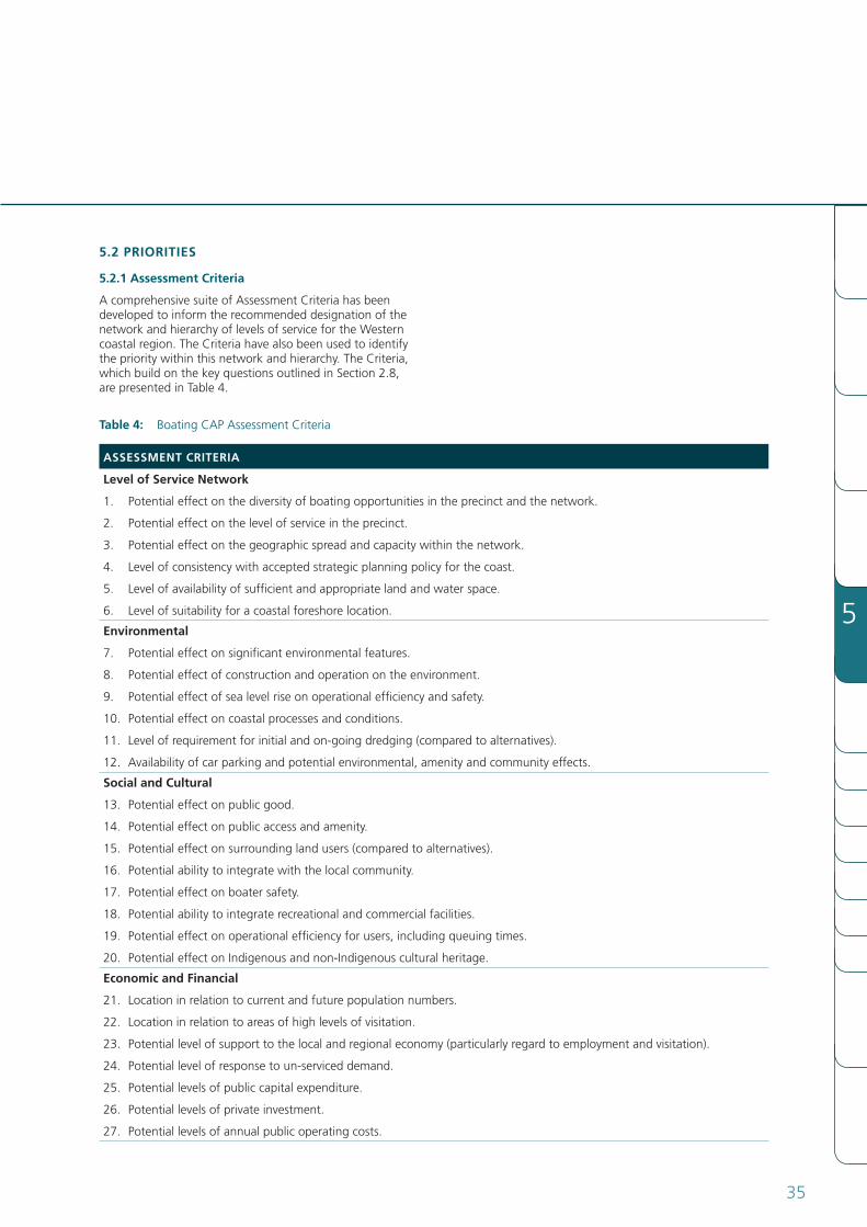
table 4: Boating CAP Assessment Criteria
ASSeSSMeNt CRiteRiA
Level of Service Network
1. Potential effect on the diversity of boating opportunities in the precinct and the network.
2. Potential effect on the level of service in the precinct.
3. Potential effect on the geographic spread and capacity within the network.
4. level of consistency with accepted strategic planning policy for the coast.
5. level of availability of sufficient and appropriate land and water space.
6. Levelofsuitabilityforacoastalforeshorelocation.
environmental
7. Potential effect on significant environmental features.
8. Potential effect of construction and operation on the environment.
9. Potential effect of sea level rise on operational efficiency and safety.
10. Potential effect on coastal processes and conditions.
11. level of requirement for initial and on-going dredging (compared to alternatives).
12. Availability of car parking and potential environmental, amenity and community effects.
Social and Cultural
13. Potential effect on public good.
14. Potential effect on public access and amenity.
15. Potential effect on surrounding land users (compared to alternatives).
16. Potentialabilitytointegratewiththelocalcommunity.
17. Potential effect on boater safety.
18. Potential ability to integrate recreational and commercial facilities.
19. Potential effect on operational efficiency for users, including queuing times.
20. Potential effect on Indigenous and non-Indigenous cultural heritage.
economic and Financial
21. location in relation to current and future population numbers.
22. location in relation to areas of high levels of visitation.
23. Potential level of support to the local and regional economy (particularly regard to employment and visitation).
24. Potential level of response to un-serviced demand.
25. Potential levels of public capital expenditure.
26. Potentiallevelsofprivateinvestment.
27. Potential levels of annual public operating costs.
5.2 PRiORitieS
5.2.1 Assessment Criteria
A comprehensive suite of Assessment Criteria has been developed to inform the recommended designation of the network and hierarchy of levels of service for the Western coastal region. The Criteria have also been used to identify the priority within this network and hierarchy. The Criteria, which build on the key questions outlined in Section 2.8, are presented in Table 4.
WES
TER
N V
ICTO
RIA
BO
ATI
Ng
CO
AST
Al
AC
TIO
N P
lAN
36
Future Network of Facilities
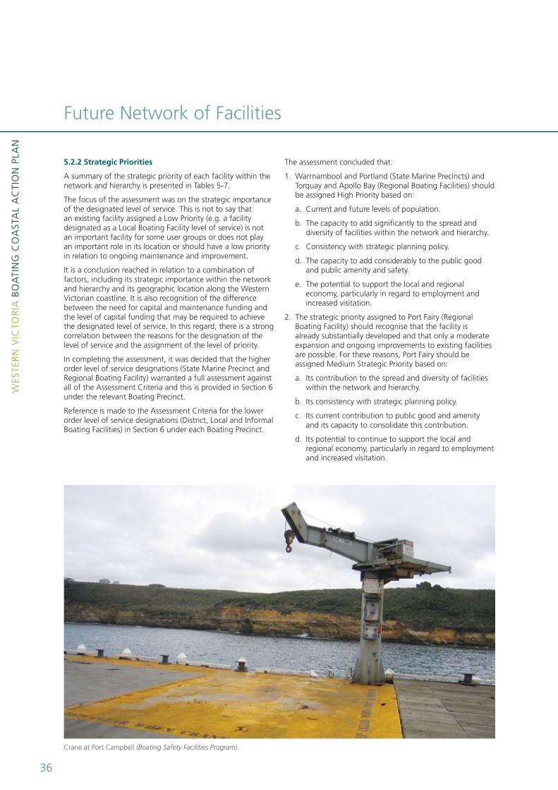
Crane at Port Campbell (Boating Safety Facilities Program).
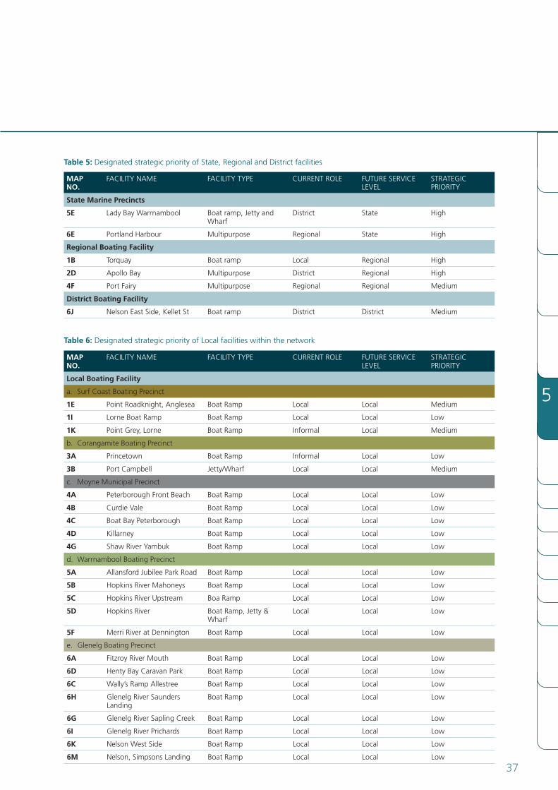
The assessment concluded that:
1. Warrnambool and Portland (State Marine Precincts) and Torquay and Apollo Bay (Regional Boating Facilities) should be assigned High Priority based on:
a. Current and future levels of population.
b. The capacity to add significantly to the spread and diversity of facilities within the network and hierarchy.
c. Consistency with strategic planning policy.
d. The capacity to add considerably to the public good and public amenity and safety.
e. The potential to support the local and regional economy, particularly in regard to employment and increased visitation.
2. The strategic priority assigned to Port Fairy (Regional Boating Facility) should recognise that the facility is already substantially developed and that only a moderate expansion and ongoing improvements to existing facilities are possible. For these reasons, Port Fairy should be assigned Medium Strategic Priority based on:
a. Its contribution to the spread and diversity of facilities within the network and hierarchy.
b. Its consistency with strategic planning policy.
c. Its current contribution to public good and amenity and its capacity to consolidate this contribution.
d. Its potential to continue to support the local and regional economy, particularly in regard to employment and increased visitation.
5.2.2 Strategic Priorities
A summary of the strategic priority of each facility within the network and hierarchy is presented in Tables 5-7.
The focus of the assessment was on the strategic importance of the designated level of service. This is not to say that an existing facility assigned a low Priority (e.g. a facility designated as a local Boating Facility level of service) is not an important facility for some user groups or does not play an important role in its location or should have a low priority in relation to ongoing maintenance and improvement.
It is a conclusion reached in relation to a combination of factors, including its strategic importance within the network and hierarchy and its geographic location along the Western Victorian coastline. It is also recognition of the difference between the need for capital and maintenance funding and the level of capital funding that may be required to achieve the designated level of service. In this regard, there is a strong correlation between the reasons for the designation of the level of service and the assignment of the level of priority.
In completing the assessment, it was decided that the higher order level of service designations (State Marine Precinct and Regional Boating Facility) warranted a full assessment against alloftheAssessmentCriteriaandthisisprovidedinSection6under the relevant Boating Precinct.
Reference is made to the Assessment Criteria for the lower order level of service designations (District, local and Informal BoatingFacilities)inSection6undereachBoatingPrecinct.
5
37
MAP NO.
FACIlITY NAME FACIlITY TYPE CURRENT ROlE FUTURE SERVICE lEVEl
STRATEgIC PRIORITY
Local Boating Facility
a. Surf Coast Boating Precinct
1e Point Roadknight, Anglesea Boat Ramp local local Medium
1i lorne Boat Ramp Boat Ramp local local low
1K Point grey, lorne Boat Ramp Informal local Medium
b. Corangamite Boating Precinct
3A Princetown Boat Ramp Informal local low
3B Port Campbell Jetty/Wharf local local Medium
c. Moyne Municipal Precinct
4A Peterborough Front Beach Boat Ramp local local low
4B Curdie Vale Boat Ramp local local low
4C Boat Bay Peterborough Boat Ramp local local low
4D Killarney Boat Ramp local local low
4G Shaw River Yambuk Boat Ramp local local low
d. Warrnambool Boating Precinct
5A Allansford Jubilee Park Road Boat Ramp local local low
5B Hopkins River Mahoneys Boat Ramp local local low
5C Hopkins River Upstream Boa Ramp local local low
5D Hopkins River BoatRamp,Jetty&Wharf
local local low
5F Merri River at Dennington Boat Ramp local local low
e. glenelg Boating Precinct
6A Fitzroy River Mouth Boat Ramp local local low
6D Henty Bay Caravan Park Boat Ramp local local low
6C Wally’s Ramp Allestree Boat Ramp local local low
6H glenelg River Saunders landing
Boat Ramp local local low
6G glenelg River Sapling Creek Boat Ramp local local low
6i glenelg River Prichards Boat Ramp local local low
6K Nelson West Side Boat Ramp local local low
6M Nelson, Simpsons landing Boat Ramp local local low
table 6: Designated strategic priority of local facilities within the network
MAP NO.
FACIlITY NAME FACIlITY TYPE CURRENT ROlE FUTURE SERVICE lEVEl
STRATEgIC PRIORITY
State Marine Precincts
5e lady Bay Warrnambool Boat ramp, Jetty and Wharf
District State High
6e Portland Harbour Multipurpose Regional State High
Regional Boating Facility
1B Torquay Boat ramp local Regional High
2D Apollo Bay Multipurpose District Regional High
4F Port Fairy Multipurpose Regional Regional Medium
District Boating Facility
6J Nelson East Side, Kellet St Boat ramp District District Medium
table 5: Designated strategic priority of State, Regional and District facilities
WES
TER
N V
ICTO
RIA
BO
ATI
Ng
CO
AST
Al
AC
TIO
N P
lAN
38
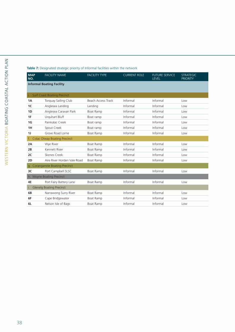
MAP NO.
FACIlITY NAME FACIlITY TYPE CURRENT ROlE FUTURE SERVICE lEVEl
STRATEgIC PRIORITY
informal Boating Facility
i. Surf Coast Boating Precinct
1A Torquay Sailing Club Beach Access Track Informal Informal low
1C Anglesea landing landing Informal Informal low
1D Anglesea Caravan Park Boat Ramp Informal Informal low
1F Urquhart Bluff Boat ramp Informal Informal low
1G Painkalac Creek Boat ramp Informal Informal low
1H Spout Creek Boat ramp Informal Informal low
1J grove Road lorne Boat Ramp Informal Informal low
f. Colac Otway Boating Precinct
2A Wye River Boat Ramp Informal Informal low
2B Kennett River Boat Ramp Informal Informal low
2C Skenes Creek Boat Ramp Informal Informal low
2D Aire River Horden Vale Road Boat Ramp Informal Informal low
g. Corangamite Boating Precinct
3C Port Campbell SlSC Boat Ramp Informal Informal low
h. Moyne Boating Precinct
4e Port Fairy Battery lane Boat Ramp Informal Informal low
i. glenelg Boating Precinct
6B Narrawong Surry River Boat Ramp Informal Informal low
6F Cape Bridgewater Boat Ramp Informal Informal low
6L Nelson Isle of Bags Boat Ramp Informal Informal low
table 7: Designated strategic priority of Informal facilities within the network