Embed Size (px)
Citation preview

FUGRO VIRTUAL WORLDEnhanced management of power transmission and distribution networks through remote asset investigation, network condition assessment and performance monitoring.
HOSTED ASSET MANAGEMENTFugro Roames hosts an asset simulation
environment for use by infrastructure
managers to investigate and monitor the
condition and performance of their network.
Our unique approach combines innovative
mapping techniques with cutting-edge data
processing and cloud computing
capabilities to deliver a complete and
accurate 3D virtual model of a power
company’s assets. Understanding an
assets evolving context, managers can tune
their capital and maintenance programs
and operational incident response to reduce
operational risks and costs, while improving
customer service.
SERVICE SHEET ROAMES
Using an accelerated mapping approach,
imagery and 3D data is collected over the
network’s assets on an annual basis and
processed in the cloud. The resulting 3D
engineering quality model of the complete
asset network reveals the surrounding
natural and built environment, enabling
comprehensive management services and
critical infrastructure condition evaluation.
Through web-based reporting and
visualisation tools, Roames allows users to
remotely inspect and evaluate features,
reducing the risk and investment associated
with performing large-scale, ongoing
inspections. Roames’ virtual-based
intelligence can provide a 40% annual
savings relative to traditional asset
management costs.
WWW.FUGRO.COM/ROAMES 1
Roames generated height map.
Roames vegetation management services include all
specified levels of vegetation from tree down to shrub.

Roames identifies the network and classifies conductors by voltage, which enables varying risk profiles to be defined. Pictured is the
Roames modeled network visualisations with the High Voltage (HV) lines identified in red, and the Low Voltage (LV) in green.
CLOUD DELIVERYRoames provides end-to-end data capture,
storage and cloud delivery services
eliminating the need for terabytes of server
space. Our spatial data is presented in an
interactive, 3D visualisation environment
using Google Earth layers or through an
existing client GIS system. Web-based
delivery removes the dependency and risk
for in-house sourcing and management of
spatial and big data specialists, as well as
the associated capital investment and
ongoing operational overhead.
SUBSCRIPTION SERVICESAsset management services provided
through Roames monthly subscription
include the following:
Network Model – A precise and complete
3D electricity model of every pole, wire and
circuits with connectivity and network
voltages. Consistent and reliable modeling
of the full LV network including customer
service wires. The model provides complete
asset attribute and measurement data
including all distances (wire lengths, pole
and attachment point heights, circuit
configuration etc.). Roames asset matching
capabilities automatically match the real
world network to a GIS network.
Vegetation Management – Our vegetation
management services include full
assessment of all vegetation (trees, shurbs
and scrub) against a utilities’ specific
business rules; complete risk assessment
using regrowth with vegetation analytics
and desk-top scoping solution; provision of
annual contractor audits ensuring
compliance; modeling of every individual
tree including its annual growth and
proximity to the powerline.
Conductor Clearance – Monitoring of every
conductor’s clearances (ground, road, rail,
rivers, driveways, buildings) for object
separation and interaction to manage risks
associated with collision avoidance,
clearance compliance, safety approach
distances, or electrical ionisation. Modeling
accounts for the moving of objects
including swinging and thermal expansion.
Structures – Individual assessment and
condition tracking of each reconstructed
virtual world asset object for movement and
distortion (pole verticality, cross-arm
bowing, conductor attachment), mechanical
loading (pole top), and ground subsidence
(erosion around the asset and in the
powerline corridor).
Energy – Improved energy forecasting and
modeling of customer premise consumption
requirements that assess alternative energy
supply strategies by merging existing
energy modeling algorithms with new
parameters from its virtual world such as
the size and aspect of buildings, the
existence of PV cells and solar hot water
systems.
Asset Condition Assessment – Condition
and defect risk based assessment of every
pole, cross-arm and hardware, insulator,
attachments and mounted equipment from
environmental related asset deterioration
including corona and thermal radiation,
moisture, dust, corrosion, lighting surges,
electrical arching.
Asset Identification and Inventory -
Independent rebuilding of key asset
registers with precision physical models and
classification suitable for asset valuation, bill
of material management, operations
modeling and financial modeling.
2 FUGRO ROAMES
BENEFITSRoames virtual world services offer the
following benefits:
■■ Annual cost savings of up to 40%
relative to traditional costs through
reduced or eliminated infield inspection
cycles, early defect discovery and
preventative maintenance approaches,
optimised strategic responses and
work plans.
■■ Standardised asset management
practices network-wide through the
consistent application of client specific
business rules, and risk based
assessment and responses.
■■ 100% annual audit of a network status,
completed contractor works and asset
condition rectifications ensures full
network compliance.
■■ In-situ 3D network models complete
corporate information systems with
precise asset locations, missing
network and asset attribute data which
enhances internal processes and drive
efficiencies across departments.
■■ Eliminates millions of kilometers of
ground travel per year associated with
infield inspection, audit, information
collection and investigation significantly
reducing the risk exposure, safety
incidences, and environmental
footprint.
■■ Removes ambiguity of spatial
inaccuracies and establishes a
common dataset that enables
infrastructure providers in the same
region to securely share and exchange
asset details.
■■ Reduces costs associated with
infrastructure management, storing,
accessing and processing data.
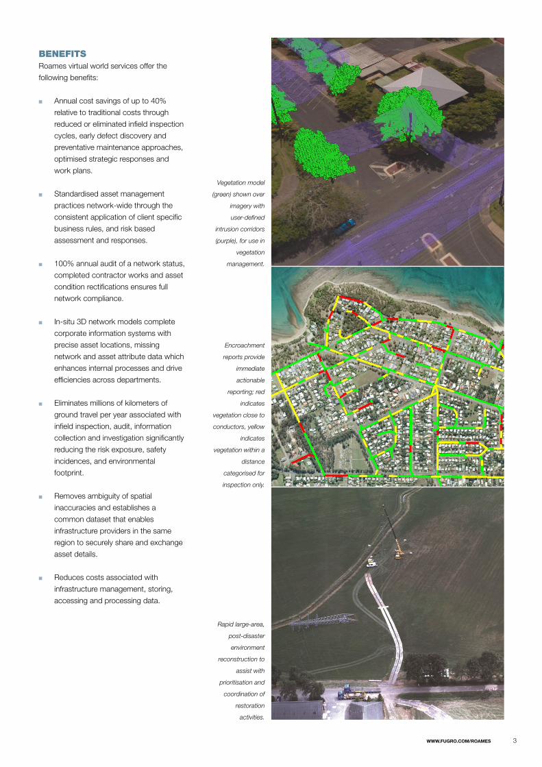
Vegetation model
(green) shown over
imagery with
user-defined
intrusion corridors
(purple), for use in
vegetation
management.
Encroachment
reports provide
immediate
actionable
reporting; red
indicates
vegetation close to
conductors, yellow
indicates
vegetation within a
distance
categorised for
inspection only.
Rapid large-area,
post-disaster
environment
reconstruction to
assist with
prioritisation and
coordination of
restoration
activities.
WWW.FUGRO.COM/ROAMES 3

A COLLABORATIVE APPROACHRemote asset management is becoming
the best practice standard to ensure safe,
reliable, and compliant networks and to
achieve business efficiencies with affordable
network access. By using virtual world
asset management systems, organisations
can view the health and status of the entire
network in near real-time to remotely
implement cost effective and optimised
asset management practices. Roames
services promote and enable a collaborative
approach to asset management through:
■■ Multi-owner cost sharing of primary
inspection tasks.
■■ Inter-owner collaboration and hence
improved alignment in critical
infrastructure planning and
establishment of regional priority
infrastructure plans.
■■ Multi-agent incident response
alignment allowing a single trusted
view of an incident response area.
SERVICE SHEET ROAMES
WWW.FUGRO.COM/ROAMES
© FU
GR
O 05 2015/FC
ST
APPLICATIONSThe market for Roames Virtual World
extends well beyond infrastructure and
asset management applications to a wide
range of industries and applications,
including insurance, construction,
transportation, property and natural
resource management.
Roames provides the tools required to
inexpensively visualise and analyse
widespread 3D assets on a scale
measuring millions of square kilometres.
Implementing Roames results in:
■■ Improved planning and operational
performance.
■■ Reduced risk thus improving
affordability.
■■ Accelerated response to emergencies
or natural disasters.
■■ Increased safety near dangerous
infrastructure.
■■ Reduced field visits.
■■ Decrease environmental impact.
4