Embed Size (px)
Citation preview
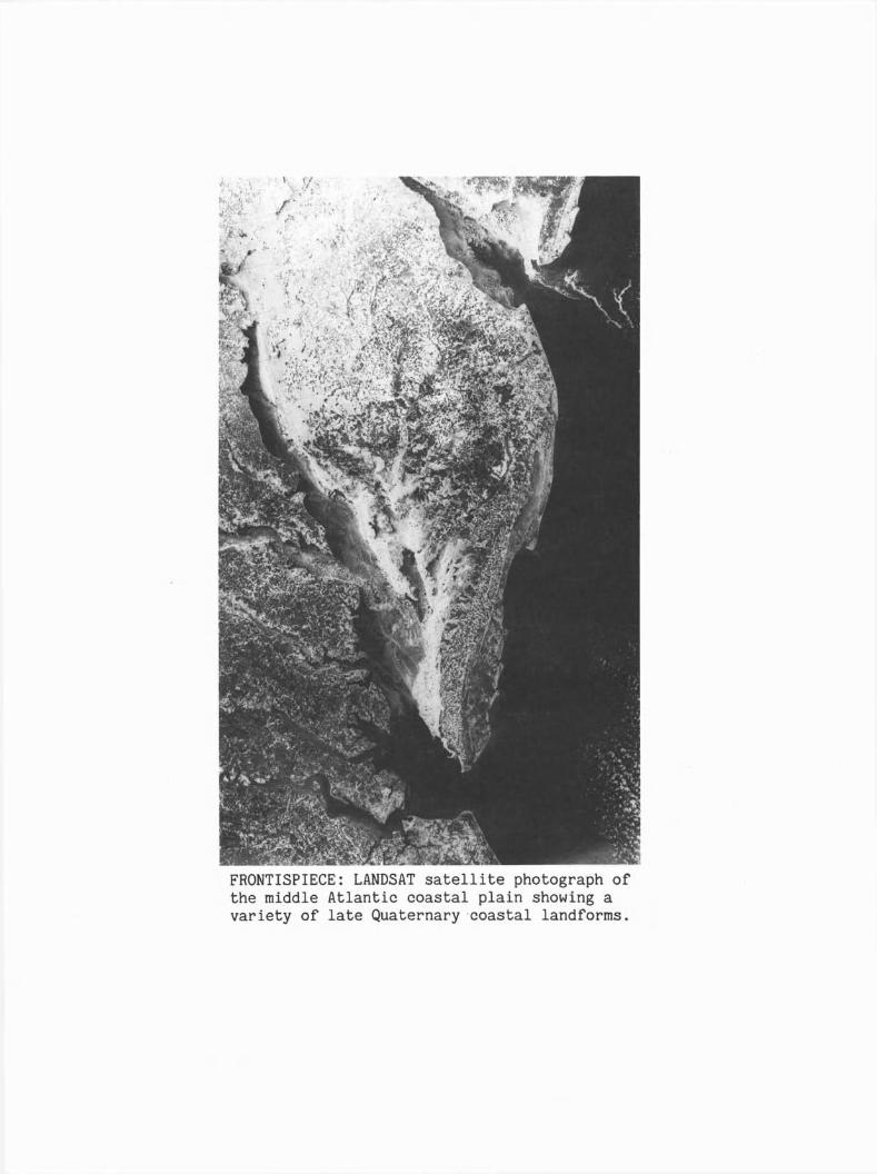
FRONTISPIECE: LANDSAT satellite photograph ofthe middle Atlantic coastal plain showing avariety of late Quaternary ·coastal landforms.
Ayover Showing Geomorphologyand Coastal Processes
Along the Atlantic Shoreline
Cape Henlopen, Delaware to Cape Charles, Virginia
July 17-18,1989
Field Trip Guidebook T219
Leader: s. Jeffress Williams
American Geophysical Union, Washington, D.C.
Leader:
S. Jeffress WilliamsU.S. Geological Survey
914 National CenterReston, VA 22092
Published 1989 by American Geophysical Union
2000 Florida Ave., N.W., Washington, D.C 20009
ISBN: 0-87590-553-6
Printed in the United States of America
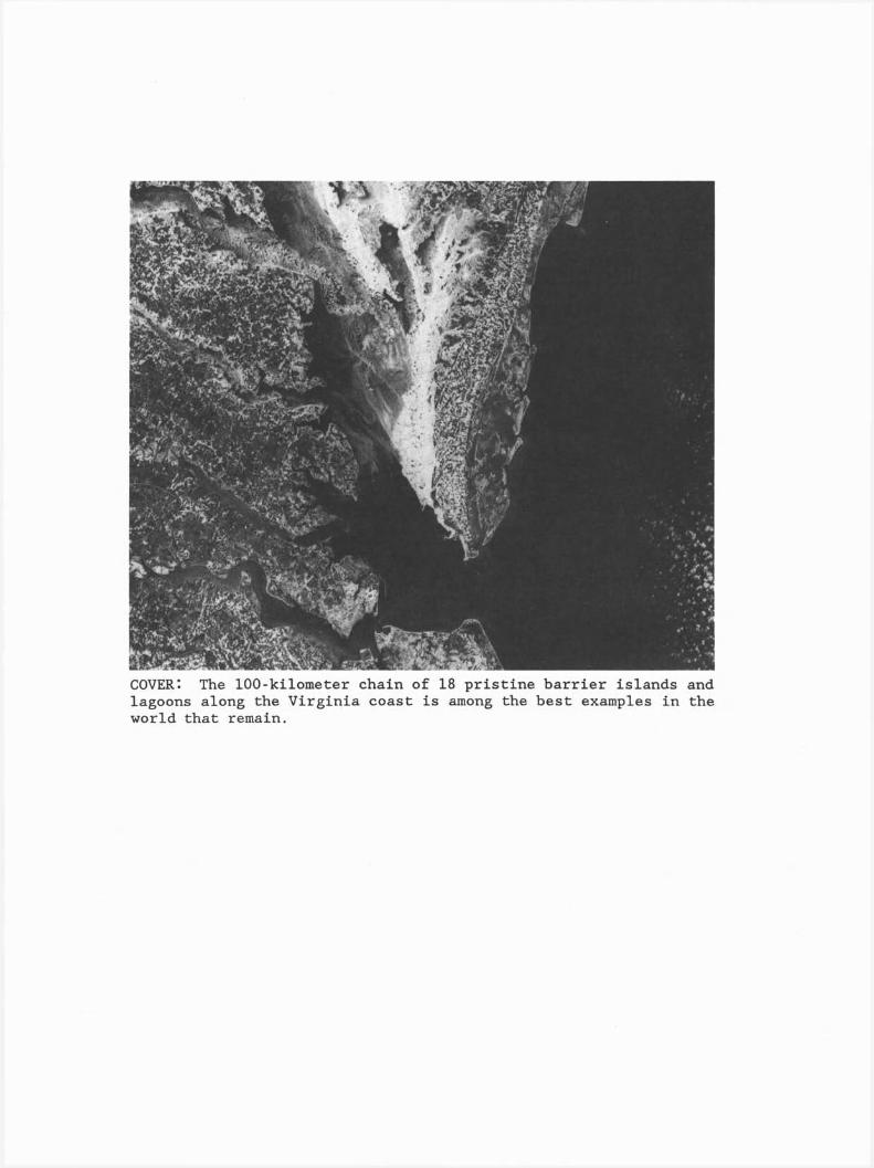
COVER: The 100-ki1ometer chain of 18 pristine barrier islands andlagoons along the Virginia coast is among the best examples in theworld that remain.
CONTENTS
PAGE
Introduction 1
Purpose of fly-over field trip 1
Delmarva Coas tal Zone.............................................. 3
Delaware Coast................................................ 3
Maryland Coast. . . . . . . . . . . . . . . . . . . . . . . . . . . . . . . . . . . . . . . . . . . . . . .. 3
Virginia Coast 4
Geomorphology and Coastal Geology 6
Process of Coastal Evolution 6
Stratigraphy of Holocene Transgressive Deposits 8
Delaware Coast )
Maryland Coast. . . . . . . . . . . . . . . . . . . . . . . . . . . . . . . . . . . . . . . . . . .. 8
Virginia Coast..................................... . . . . . .. 8
Holocene Sea-Level History 10
Modern Sea-Level Rise 11
Future Coastal Evolution 11
Acknowledgments 12
References 12
Table 1.
Figures
1.
2.
3.
4.
5.
6.
7.
8.
9.
10.
11.
12.
13.
14.
Location Map. . . . . . . . . . . . . . . . . . . . . . . . . . . . . . . . . . . . . . . . . . . . .. 2
Aerial photo of the Delaware Coast 3
Aerial photo of Ocean City, Maryland 4
Aerial photo. of Ocean City Inlet, Maryland 4
Aerial photo of Gargathy Inlet, Virginia 5
Virginia coast change map 5
Quaternary geologic map 7
Delaware coast change map 8
Delaware coast dip sections 9
Maryland coast change map 9
Shoreline change map of Fishing Point, Virginia 10
Southern Delmarva Peninsula map 10
Virginia coast dip sections 11
Holocene sea-level curve for the Delaware coast 11
Recent coastal erosion and sea-level rise rates 12
vii
IGC FIELD TRIP T219:GEOMORPHOLOGY AND COASTAL PROCESSES ALONG THE ATLANTIC SHORELINE J
CAPE HENLOPEN J DElAWARE TO CAPE CHARLES J VIRGINIA
S. Jeffress WilliamsU.S. Geological Survey, Reston, Virginia
INTRODUCTION
The more than 4,000 km of barrierislands along the U.S. Atlantic coast andGulf of Mexico comprise one of thelargest, most diverse and most studiedcoastal barrier chains in the world.Within this chain, the coastal compartmentfrom Delaware Bay to Chesapeake Bay offerssuperb examples of a variety of coastaland nearshore environments and shorelinefeatures.
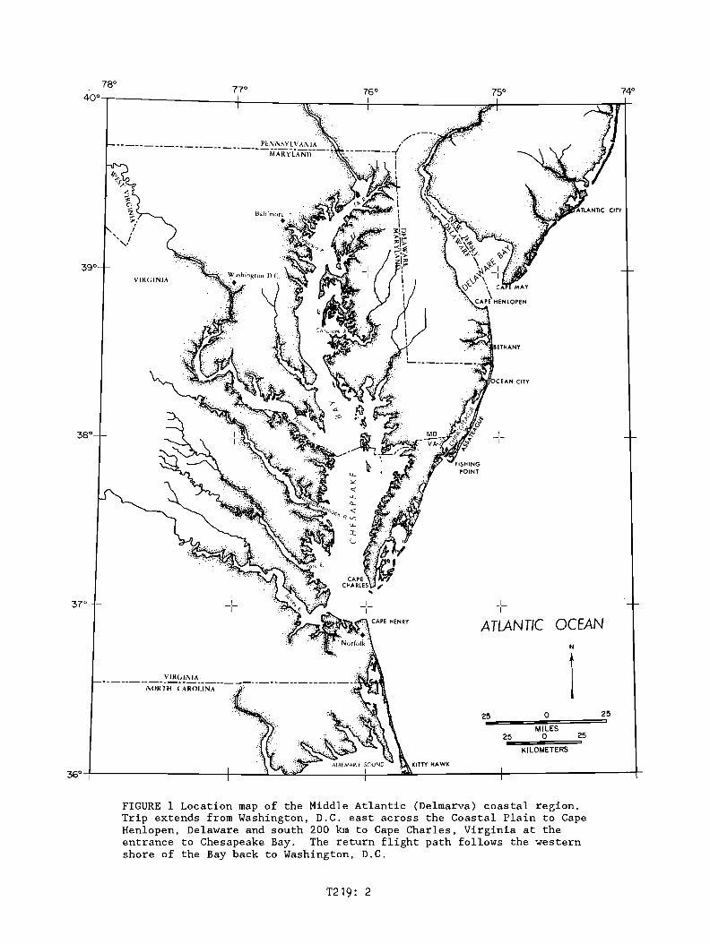
The flight path of the field trip willextend from Washington, D.C. at the FallLine, east across the Atlantic CoastalPlain to Cape Henlopen, Delaware, at theentrance to the Delaware River estuary,and then south along the Maryland andVirginia coast to Cape Charles, Virginia(Fig. 1). The subaerial part of the U.S.Atlantic Coastal Plain is about 185 kmwide, while the width of the submergedcontinental shelf portion is approximately100 km. The portion of Coastal Plain thatwe will fly over, as well as that alongthe rest of the Atlantic margin, hasrelatively low physiographic relief andconsists of a seaward-dipping andthickening wedge of only slightly deformedsiliclastic sedimentary units ofCretaceous, Tertiary and Quaternary age.
From Cape Henlopen, Delaware, southapproximately 200 km to Cape CharlesVirginia at the entrance of ChesapeakeBay, the Delmarva (Delaware-MarylandVirginia) coastal compartment consists ofa variety of marine and estuarineenvironments and landforms. These havebeen dominated by late Quaternary sealevel rise of at least 100 m and also theresultant marine transgression that iscontinuing to the present time.
The return flight to Washington, D.C.,will afford an excellent view of the lowerparts of Chesapeake Bay, the largest andmost biologically diverse and productiveestuary in the U.S. (Fig. 1). The modernBay originated about 5 ka when sea levelrose high enough to flood the deeplyscoured ancestral fluvial valleys of themore than 12 rivers that converged at theaxis of the Bay. Recent seismicreflection surveys in Chesapeake Bayreveal a complex geologic history of
T219:
sediment in-filling and down-cuttingassociated with multiple sea-levelfluctuations over the past 2 millionyears. These evolutionary processes arecontinuing at the present time withadditional significant human impactsduring the past several decades. Coastalerosion and pollution of Chesapeake Bayand the rivers entering the Bay are nowfinally being recognized as seriousproblems, and efforts to mitigate theseare becoming a high priority with Federal,State and local governments.
Purpose of fly-over field trip
The one-day overflight will enable tripparticipants to observe, photograph andstudy a wide variety of landforms andgeologic features within the MiddleAtlantic Coastal Plain Province. Emphasiswill be on late Quaternary coastalfeatures and the processes responsible fortheir formation and evolution. Beginningin Washington, D.C., we will fly east toCape Henlopen, Delaware, and then south,along the coast at a low altitude, to CapeCharles at the entrance to the ChesapeakeBay estuary (Fig. 1). Examples of latePleistocene and Holocene landforms to beobserved and discussed include: CapeHenlopen spit rapidly prograding northinto Delaware Bay, the eroding headlandand sand-starved bay-mouth barrier coastof Delaware, and the highly developedbarrier spit containing Ocean City,Maryland, with its closely spaced highrise buildings and a recently completedbeach nourishment project. Downdrift fromthe jettied Ocean City Inlet, northernAssateague Island will offer a classicexample of a sediment-starved coast due toman-made causes. Farther south FishingPoint spit is an example of natural causesof littoral-drift disruption. Along theVirginia coast, 18 short and narrow,pristine, barrier islands and associatedlagoonal wetlands are undergoing rapidnatural changes.
Our return flight will offer excellentviewing of lower parts of the ChesapeakeBay as well as the Potomac River and otherrivers that enter the Bay.
· 78° 770 760 750 740
4ooT'----------tl----~rv:_~---+:--------~~4-I-------__:'......,.lW"'"~
CITY
VIRGINIA
I-1-
ATLANTIC OCEANN
125 0 25
MILES25 0 25
KILOMETERS
36°+1-----------+---....:..;J...:...:~~-----~--~........------_+-----------r
FIGURE 1 Location map of the Middle Atlantic (Delmarva) coastal region.Trip extends from Washington, D.C. east across the Coastal Plain to CapeHenlopen, Delaware and south 200 km to Cape Charles, Virginia at theentrance to Chesapeake Bay. The return flight path follows the westernshore of the Bay back to Washington, D.C.
T219: 2
DEl.MARVA COASTAL ZONE
Delaware Coast
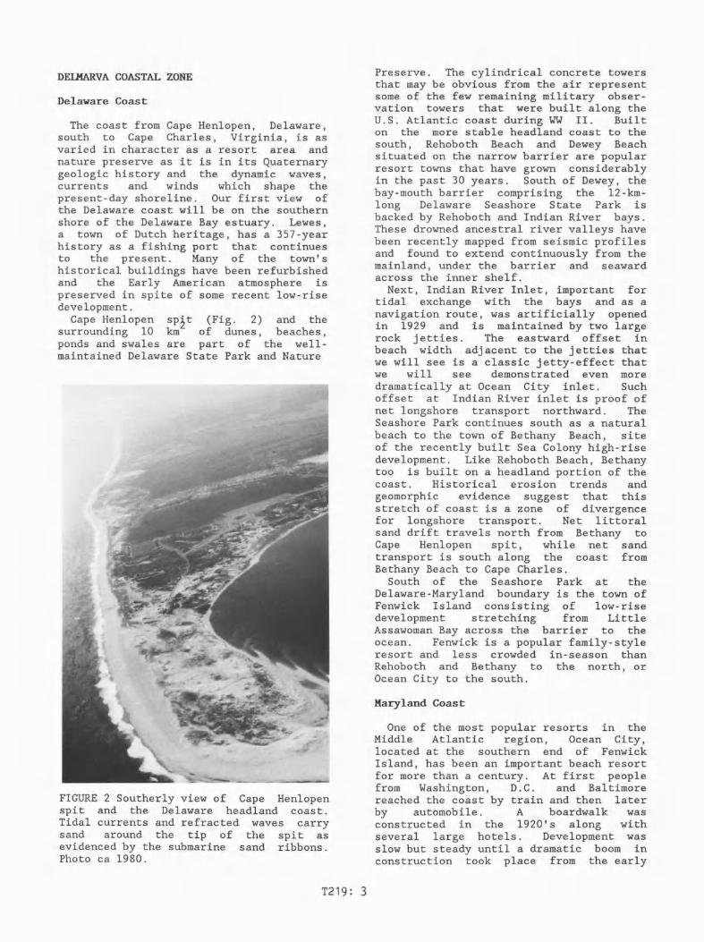
The coast from Cape Henlopen, Delaware,south to Cape Charles, Virginia, is asvaried in character as a resort area andnature preserve as it is in its Quaternarygeologic history and the dynamic waves,currents and winds which shape thepresent-day shoreline. Our first view ofthe Delaware coast will be on the southernshore of the Delaware Bay estuary. Lewes,a town of Dutch heritage, has a 357-yearhistory as a fishing port that continuesto the present. Many of the town'shistorical buildings have been refurbishedand the Early American atmosphere ispreserved in spite of some recent low-risedevelopment.
Cape Henlopen sp~t (Fig. 2) and thesurrounding 10 km of dunes, beaches,ponds and swales are part of the wel1maintained Delaware State Park and Nature
FIGURE 2 Southerly view of Cape Henlopenspit and the Delaware headland coast.Tidal currents and refracted waves carrysand around the tip of the spit asevidenced by the submarine sand ribbons.Photo ca 1980.
T219: 3
Preserve. The cylindrical concrete towersthat may be obvious from the air representsome of the few remaining military observation towers that were built along theU.S. Atlantic coast during WW II. Builton the more stable headland coast to thesouth, Rehoboth Beach and Dewey Beachsituated on the narrow barrier are popularresort towns that have grown considerablyin the past 30 years. South of Dewey, thebay-mouth barrier comprising the 12-kmlong Delaware Seashore State Park isbacked by Rehoboth and Indian River bays.These drowned ancestral river valleys havebeen recently mapped from seismic profilesand found to extend continuously from themainland, under the barrier and seawardacross the inner shelf.
Next, Indian River Inlet, important fortidal exchange with the bays and as anavigation route, was artificially openedin 1929 and is maintained by two largerock jetties. The eastward offset inbeach width adjacent to the jetties thatwe will see is a classic jetty-effect thatwe will see demonstrated even moredramatically at Ocean City inlet. Suchoffset at Indian River inlet is proof ofnet longshore transport northward. TheSeashore Park continues south as a naturalbeach to the town of Bethany Beach, siteof the recently built Sea Colony high-risedevelopment. Like Rehoboth Beach, Bethanytoo is built on a headland portion of thecoast. Historical erosion trends andgeomorphic evidence suggest that thisstretch of coast is a zone of divergencefor longshore transport. Net littoralsand drift travels north from Bethany toCape Henlopen spit, while net sandtransport is south along the coast fromBethany Beach to Cape Charles.
South of the Seashore Park at theDelaware-Maryland boundary is the town ofFenwick Island consisting of low-risedevelopment stretching from LittleAssawoman Bay across the barrier to theocean. Fenwick is a popular family-styleresort and less crowded in-season thanRehoboth and Bethany to the north, orOcean City to the south.
Maryland Coast
One of the most popular resorts in theMiddle Atlantic region, Ocean City,located at the southern end of FenwickIsland, has been an important beach resortfor more than a century. At first peoplefrom Washington, D.C. and Baltimorereached the coast by train and then. laterby automobile. A boardwalk wasconstructed in the 1920's along withseveral large hotels. Development wasslow but steady until a dramatic boom inconstruction took place from the early
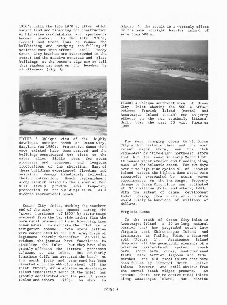
1950's until the late 1970's, after whichvacant land and financing for constructionof high-rise condominiums and apartmentsbecame scarce. In the late 1970'sFederal and State laws to reduce th~bulkheading and dredging and filling ofwetlands came into effect. Still, todayOcean City beaches are overcrowded in thesummer and the massive concrete and glassbuildings at the water's edge are so tallthat shadows are cast on the beaches bymidafternoon (Fig. 3).
FIGURE 3 Oblique view of the highlydeveloped barrier beach at Ocean City,Maryland (ca 1980). Protective dunes thatonce existed have been removed, and thebuildings constructed too close to thewater allow little room for stormprocesses and seasonal and longtermfluctuations of the shoreline. Many ofthese buildings experienced flooding andsustained damage immediately followingtheir construction. Beach replenishmentalong Fenwick Island in the summer of 1988will likely provide some temporaryprotection to the buildings as well as awidened recreational beach.
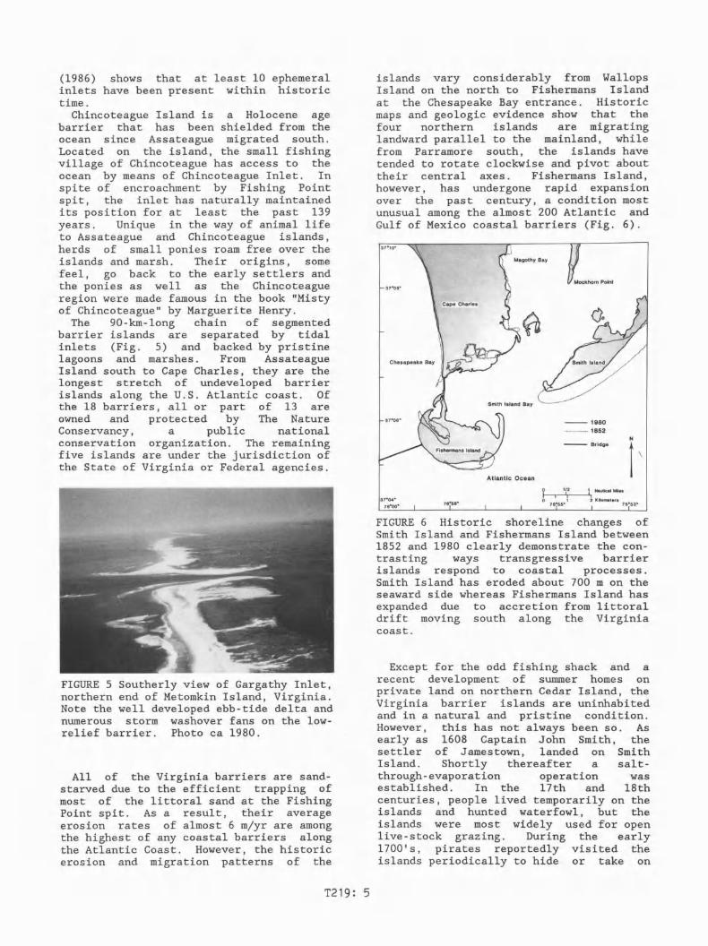
Ocean City inlet, marking the southernend of the city, was opened during the"great hurricane of 1933" by storm-surgeoverwash from the bay side rather than themore usual process of inlet breeching fromocean waves. To maintain the inlet as anavigation channel, twin stone jettieswere constructed by the U.S. Army Corps ofEngineers shortly thereafter. As will beevident, the jetties have functioned tostabilize the inlet, but they have alsogreatly affected the littoral processesadjacent to the inlet. Net southerlylongshore drift has accreted the beach atthe north jetty and some sand has beendiverted onto the ebb-tide shoal off theinlet throat, while erosion on AssateagueIsland immediately south of the inlet hasgreatly accelerated over the past 50 years(Dolan and others, 1980). As shown in
Figure 4, the result is a westerly offsetin the once straight barrier island ofmore than 500 m.
FIGURE 4 Oblique southwest view of OceanCity Inlet showing the 500 m offsetbetween Fenwick Island (north) andAssateague Island (south) due to jettyeffects on the net southerly littoraldrift over the past 50 yrs. Photo ca1980.
The most damaging storm to hit OceanCity within historic times and the mostrecent major storm, was the "AshWednesday" or "Five-High" northeast stormthat hit the coast in early March 1962.It caused major erosion and flooding alongmuch of the Atlantic coast. For two daysover five high-tide cycles all of FenwickIsland except the highest dune areas wererepeatedly overwashed by storm wavessuperimposed on the 2-m surge. Propertydamage to Ocean City alone was estimatedat $7.5 million (Dolan and others, 1980).With the extent of dense developmenttoday, damage from a similar such stormwould likely be hundreds of millions ofdollars.
Virginia Coast
To the south of Ocean City inlet isAssateague Island, a 50-km-Iong naturalbarrier that has prograded south intoVirginia past Chincoteague Island andterminates at Fishing Point, a recurvedspit (Figure 1). Assateague Islanddisplays all the geomorphic elements of apristine barrier-beach system: swashbars, storm berm, dunes, washover sandflats, back barrier lagoons and tidalmarshes, and old tidal inlets that havebeen filled by littoral drift. Relictinlets, however, are still obvious fromthe curved beach ridges present. Atpresent there are no active tidal inletsalong Assateague Island, but McBride
T219: 4
islands vary considerably from WallopsIsland on the north to Fishermans Islandat the Chesapeake Bay entrance. Historicmaps and geologic evidence show that thefour northern islands are migratinglandward parallel to the mainland, whilefrom Parramore south, the islands havetended to rotate clockwise and pivot abouttheir central axes. Fishermans Island,however, has undergone rapid expansionover the past century, a condition mostunusual among the almost 200 Atlantic andGulf of Mexico coastal barriers (Fig. 6).
(1986) shows that at least 10 ephemeralinlets have been present within historictime.
Chincoteague Island is a Holocene agebarrier that has been shielded from theocean since Assateague migrated south.Located on the island, the small fishingvillage of Chincoteague has access to theocean by means of Chincoteague Inlet. Inspite of encroachment by Fishing Pointspit, the inlet has naturally maintainedits position for at least the past 139years. Unique in the way of animal lifeto Assateague and Chincoteague islands,herds of small ponies roam free over theislands and marsh. Their origins, somefeel, go back to the early settlers andthe ponies as well as the Chincoteagueregion were made famous in the book "Mistyof Chincoteague" by Marguerite Henry.
The 90-km-long chain of segmentedbarrier islands are separated by tidalinlets (Fig. 5) and backed by pristinelagoons and marshes. From AssateagueIsland south to Cape Charles, they are thelongest stretch of undeveloped barrierislands along the U.s. Atlantic coast. Ofthe 18 barriers, all or part of 13 areowned and protected by The NatureConservancy, a public nationalconservation organization. The remainingfive islands are under the jurisdiction ofthe State of Virginia or Federal agencies.
Atlantic Ocean
--1980···············1852
-- BridgeNI\
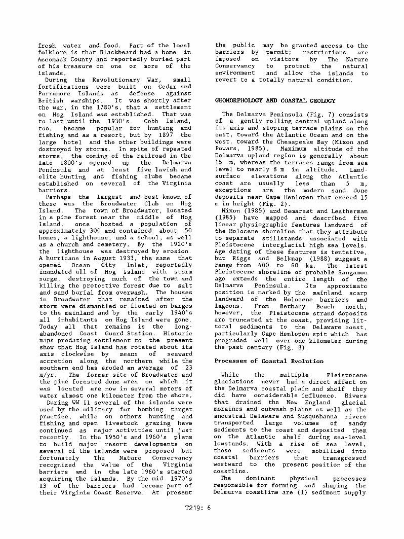
FIGURE 5 Southerly view of Gargathy Inlet,northern end of Metomkin Island, Virginia.Note the well developed ebb-tide delta andnumerous storm washover fans on the lowrelief barrier. Photo ca 1980.
All of the Virginia barriers are sandstarved due to the efficient trapping ofmost of the lit-toral sand at the FishingPoint spit. As a result, their averageerosion rates of almost 6 m/yr are amongthe highest of any coastal barriers alongthe Atlantic Coast. However, the historicerosion and migration patterns of the
T219: 5
~...---a.~----I..}i Nautical Miles
2 Kilometers
FIGURE 6 Historic shoreline changes ofSmith Island and Fishermans Island between1852 and 1980 clearly demonstr~te the contrasting ways transgressive barrierislands respond to coastal processes.Smith Island has eroded about 700 m on theseaward side whereas Fishermans Island hasexpanded due to accretion from littoraldrift moving south along the Virginiacoast.
Except for the odd fishing shack and arecent development of summer homes onprivate land on northern Cedar Island, theVirginia barrier islands are uninhabitedand in a natural and pristine condition.However, this has not always been so. Asearly as 1608 Captain John Smith, thesettler of Jamestown, landed on SmithIsland. Shortly thereafter a saltthrough-evaporation operation wasestablished. In the 17th and 18thcenturies, people lived temporarily on theislands and hunted waterfowl, but theislands were most widely used for openlive-stock grazing. During the early1700's, pirates r~portedly visited theislands periodically to hide or take on
fresh water and food. Part of the localfolklore is that Blackbeard had a home inAccomack County and reportedly buried partof his treasure on one or more of theislands.
During the Revolutionary War, smallfortifications were built on Cedar andParramore Islands as defense againstBritish warships. It was shortly afterthe war, in the 1780's, that a settlementon Hog Island was established. That wasto last until the 1930's. Cobb Island,too, became popular for hunting andfishing and as a resort, but by 1897 thelarge hotel and the other buildings weredestroyed by storms. In spite of repeatedstorms, the coming of the railroad in thelate 1800's opened up the DelmarvaPeninsula and at least five lavish andelite hunting and fishing clubs becameestablished on several of the Virginiabarriers.
Perhaps the largest and best known ofthese was the Broadwater Club on HogIsland. The town of Broadwater, locatedin a pine forest near the middle of HogIsland, once hosted a population ofapproximately 300 and contained about 50homes, a lighthouse, and a school, as wellas a church and cemetery. By the 1920'sthe lighthouse was destroyed by erosion.A hurricane in August 1933, the same thatopened Ocean City Inlet, reportedlyinundated all of Hog Island with stormsurge, destroying much of the town andkilling the protective forest due to saltand sand burial from overwash. The housesin Broadwater that remained after thestorm were dismantled or floated on bargesto the mainland and by the early 1940'sall inhabitants on Hog Island were gone.Today all that remains is the longabandoned Coast Guard Station. Historicmaps predating settlement to the presentshow that Hog Island has rotated about itsaxis clockwise by means of seawardaccretion along the northern while thesouthern end has eroded an average of 23m/yr. The former site of Broadwater andthe pine forested dune area on which itwas located are now in several meters ofwater almost one kilometer from the shore.
During WW II several of the islands wereused by the military for bombing targetpractice, while on others hunting andfishing and open livestock grazing havecontinued as major activities until justrecently. In the 1950's and 1960's plansto build major resort developments onseveral of the islands were proposed butfortunately The Nature Conservancyrecognized the value of the Virginiabarriers and in the late 1960's startedacquiring the islands. By the mid 1970's13 of the barriers had become part oftheir Virginia Coast Reserve. At present
T219: 6
the public may be granted access to thebarriers by permit; restrictions areimposed on visitors by The NatureConservancy to protect the naturalenvironment and allow the islands torevert to a totally natural condition.
GEOMORPHOLOGY AND COASTAL GEOLOGY
The Delmarva Peninsula (Fig. 7) consistsof a gently rolling central upland alongits axis and sloping terrace plains on theeast, toward the Atlantic Ocean and on thewest, toward the Chesapeake Bay (Mixon andPowars, 1985). Maximum altitude of theDelmarva upland region is generally about15 m, whereas the terraces range from sealevel to nearly 8 m in altitude. Landsurface elevations along the Atlanticcoast are usually less than 5 m,exceptions are the modern sand dunedeposits near Cape Henlopen that exceed 15m in height (Fig. 2).
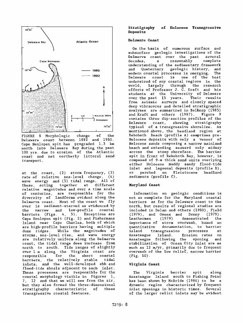
Mixon (1985) and Demarest and Leatherman(1985) have mapped and described fivelinear physiographic features landward ofthe Holocene shoreline that they attributeto separate stillstands associated withPleistocene interglacial high sea levels.Age dating of these features is tentative,but Riggs and Belknap (1988) suggest arange from 400 to 60 ka. The latestPleistocene shoreline of probable Sangamonage extends the entire length of theDelmarva Peninsula. Its approximateposition is marked by the mainland scarplandward of the Holocene barriers andlagoons. From Bethany Beach north,however, the Pleistocene strand depositsare truncated at the coast, providing littoral sediments to the Delaware coast,particularly Cape Henlopen spit which hasprograded well over one kilometer duringthe past century (Fig. 8).
Processes of Coastal Evolution
While the multiple Pleistoceneglaciations never had a direct affect onthe Delmarva coastal plain and shelf theydid have considerable influence. Riversthat drained the New England glacialmoraines and outwash plains as well as theancestral Delaware and Susquehanna riverstransported large volumes of sandysediments to the coast and deposited themon the Atlantic shelf during sea-levellowstands. With a rise of sea level,these sediments were mobilized intocoastal barriers that transgressedwestward to the present position of thecoastline.
The dominant physical processesresponsible for forming and shaping theDelmarva coastline are (1) sediment supply
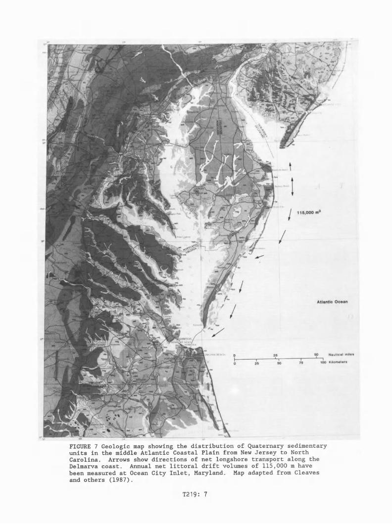
FIGURE 7 Geologic map showing the distribution of Quaternary sedimentaryunits in the middle Atlantic Coastal Plain from New Jersey to NorthCarolina. Arrows show directions of net longshore transport along theDelmarva coast. Annual net littoral drift volumes of 115,000 m havebeen measured at Ocean City Inlet, Maryland. Map adapted from Cleavesand others (1987).
T219: 7
StratigraphyDeposits
of Holocene Transgressive
Delaware Bay Atlantic Ocean Delaware Coast
FIGURE 8 Morphologic change of theDelaware coast between 1882 and 1980.Cape Henlopen spit has prograded 1.3 kmnorth into Delaware Bay during the past100 yrs. due to erosion of the Atlanticcoast and net northerly littoral sandtransport.
at the coast, (2) storm frequency, (3)rate of relative sea-level change, (4)wave energy and (5) tidal range. All ofthese, acting together at differentrelative magnitudes and over a time scaleof centuries, are responsible for thediversity of landforms evident along theDelmarva coast. Most of the coast we flyover is sediment-starved as evidenced bythe narrow and low-profile coastalbarriers (Figs. 4, 5). Exceptions areCape Henlopen spit (Fig. 2) and FishermansIsland near Cape Charles, both of whichare high-profile barriers having multipledune ridges. While the magnitudes ofstorms, sea-level rise, and wave energyare relatively uniform along the Delmarvacoast, the tidal range does increase fromnorth to south. Tide ranges of slightlyover 1 m along the Virginia coast areresponsible for the short coastalbarriers, the relatively stable tidalinlets, and the well-developed ebb andflood-tide shoals adjacent to each inlet.These processes are responsible for thecoastal morphology visible in Figures 1,7, 12 and that we will see from the air,but they also formed the three-dimensionalstratigraphy characteristic of thesetransgressive coastal features.
The Virginia barrier spit alongAssateague Island south to Fishing Pointhas been shown by McBride (1986) to be adynamic region characterized by frequentinlet openings in historic times. Severalof the larger relict inlets may be evident
Virginia Coast
Information on geologic conditions isnot as complete for the Maryland coastalbarriers as for the Delaware coast to thenorth, but results of regional studies areincluded in Dolan and others (1980), Field(1979), and Owens and Denny (1979).Leatherman (1979) demonstrated theimportance of storm overwash, based onquantitative documentation, to barrierisland transgression processes atAssateague Island. Erosion rates onAssateague following the opening andstabilization of Ocean City inlet are asmuch as 12 m/yr, primarily due to frequentoverwash of the low relief, narrow barrier(Fig. 10).
Maryland Coast
On the basis of numerous surface andsubsurface geologic investigations of theDelmarva coast over the past severaldecades, a reasonably completeunderstanding of the sedimentary frameworkand Quaternary geologic history, andmodern coastal processes is emerging. TheDelaware coast is one of the bestunderstood of any coastal regions in theworld, largely through the researchefforts of Professor J. C. Kraft and hisstudents at the University of Delawareover the past 15 years. Their resultsfrom seismic surveys and closely spaceddeep vibracores and detailed stratigraphicanalyses are summarized in Belknap (1985)and Kraft and others (1987). Figure 9contains three dip-section profiles of theDelaware coast, showing stratigraphytypical of a transgressive shoreline. Asmentioned above, the headland region atRehoboth Beach (profile A) comprises preHolocene deposits with only a veneer ofHolocene sands composing a narrow mainlandbeach and extending seaward only midwayacross the steep shoreface. The barrierspit in front of Rehoboth Bay, however, iscomposed of 9-m thick sand units overlyingeither Holocene muddy sandy flood-tideinlet and lagoonal deposits (profile B),or perched on Pleistocene headlandsediments (profile C).
N
t~ ~ Kilometers
1980
1882
1/2 1 Nautical MilesI ,
Cape Henlopen
T219: 8

I
Atlantic Ocean
__ 1980
.............. 1849
1/2 1 Kilometers
I--~+I~----&.,'J Nautical Miles
early 1930's whenopened and it was
Growth of the spityears has slowed
:....Assateague
/.:.:' Island
//'
38°15' -+------'f..--Li.--.--+----+-----+---+-___+.
FIGURE 10 Shoreline changes in the FenwickIsland-Assateague Island region between1849 and 1980 illustrate the dramaticeffects of the two large jetties at OceanCity Inlet on coastal sediment transportalong the adjacent coast.
continued until theOcean City Inletstabilized (Fig. 11).in the past 50considerably.
From Fishing Point to Cape Charles, thecoastal barriers are narrow (0.4 to 3 km),short (3 to 14 km), and commonlydrumstick-shaped (Fig. 12). Theirconfiguration and geomorphology reflectsthe dual influences of moderately large (±1 m) tide range and a deficiency oflittoral sediment due to trapping atFishing Point. The backbarrier lagoon andmarshes also vary in width from verynarrow behind the northern barriers to amaximum of about 15 km (Fig. 12) near thesouthern end. While the Virginia barriershave been shown to be dynamic featuresthat transgress landward and pivot abouttheir central axis, the tidal inletsseparating the barriers are remarkablystable. McBride (1986) shows that theinlets have maintained their relativepositions for at least the past 130 years,
c
MEANTIDAL
RANGE
!.18m
A~~~~/C A!.18m
-6
REHOBOTH BEACH
MSL 0
-2
-4
fI)
a::: -8
'"~ -10
:::IE -12
-14
-16
-18
2KILOMETERS
~N
c
-8
-6~ MARSH
LAGOONAL~ ~~~D\AND -10
-12
~ ~~~OCENE -14
--.......-8
0.15m
o
EXPLANATION
lim :~:~IER
III ~~~~~~W- -2
SAND -4
MSL 0
-2
-4
~ -6
'"~ -8
2 -10
-12
-14
-16
from the air by observing the opposingsets of recurved beach ridges. Longshoretransport along the Virginia coast is tothe south and when inlets were open in thepast, they very efficiently trappedlittoral sands. Large relict flood-tidedeltas adjacent to these inlet scars mayalso be evident in places. Most are nowvegetated and serve as platforms fordevelopment of lagoonal marshes. Asmentioned, accretion of the Fishing Pointspit has been closely linked to inletopenings and closings along Assateagueisland to the north. Following closure ofGreen Run and Pope Island inlets in the1880's (McBride, 1986), littoral drift tothe south was uninterrupted and resultedin the rapid progradation of FishingPoint. This rapid accretion of the spit
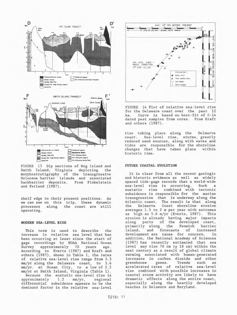
FIGURE 9 Three dip sections of thetransgressive Delaware coast based oninterpretations of long continuousvibracores. (A) Head~and coast atRehoboth Beach has a sand veneer overlyingPleistocene units. (B) Rehoboth barrieroverlies Holocene backbarrier sediments.(C) Rehoboth barrier perched on aPleistocene high at the site of a formertidal inlet and flood-tide shoal. FromKraft and others (1987).
T219: 9
OC81R City'nlBl
~
~H!!)III'.II-----+------ ~-------I
~~~
~
37°30"--~
ChesapeakeBoy
ISLAND
HOG ISLANDD ' I
COBB ISLAND.~ 1:
1 IIMOICKtIORI~ ~=*'I•••+J iI;;:- WRECK ISLAND ~~=::;J§MI=LES===:a:=~~
~ SHIP SHOAL I 0 10 20F \ ISLAND Kilometers
MYRTLE ISLAND, SMITH ISLAND I 0 5 10 15 20 25
75030'+
+
ASSATEAGUEANCHORAGE
+
+
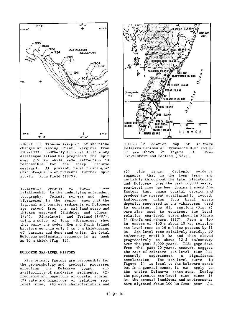
FIGURE 11 Time-series-p10t of shorelinechanges at Fishing Point, Virginia from1902-1933. Southerly littoral drift alongAssateague Island has prograded the spitover 2.5 km while wave refraction isresponsible for the sharp recurvewestward. At present, tidal flushing atChincoteague Inlet prevents further spitgrowth. From Field (1979).
apparently because of their closerelationship to the underlying antecedenttopography. Seismic surveys and deepvibracores in the region show that thelagoonal and barrier sediments of Holoceneage extend from the mainland scarp andthicken eastward (Shideler and others,1984). Finkelstein and Ferland (1987),using a suite of long vibracores, showthat while the modern Hog and Smith islandbarriers contain only 2 to 3 m thicknessesof barrier and dune sand units, the totalHolocene sedimentary sequence is as muchas 10 m thick (Fig. 13).
HOLOCENE SEA-LEVEL HISTORY
Five primary factors are responsible forthe geomorphology and geologic processesaffecting the Delmarva coast: (1)availability of sand-size sediments, (2)frequency and magnitude of coastal storms,(3) rate and magnitude of relative sealevel rise, (4) wave characteristics and
FIGURE 12 Location map of southernDelmarva Peninsula. Transects 0-0' and FF' are shown in Figure 13. FromFinkelstein and Ferland (1987).
(5) tide range. Geologic evidencesuggests that in the long term, andcertainly throughout the late Pleistoceneand Holocene over the past 18,000 years,sea-level rise has been dominant among thefactors that cause coastal erosion andproduce the present stratigraphic record.Radiocarbon dates from basal marshdeposits recovered in the vibracores usedto construct the dip sections (Fig. 9)were also used to construct the localrelative sea-level curve shown in Figure14 (Kraft and others, 1987). From a lowin excess of -100 m about 18 ka, relativesea level rose to 26 m below present by 11ka. Sea level rose relatively rapidly, 30em/century, until 5 ka and then slowedprogressively to about 12.5 em/centuryover the past 2,000 years. Tide-gage datafrom the past 70 years, however, suggestthe rate of relative sea-level rise hasrecently experienced a significantacceleration. The sea-level curve inFigure 14 is local to the Delaware coastbut in a general sense, it can apply tothe entire Delmarva coast zone. Duringthe progressive sea-level rise since 18ka, the coastal landforms and environmentshave migrated about 100 km from near the
T219: 10
HOG ISLAND TRANSECT
+---Cl4 5730 112-L1FE~ OENDRO-DATES (MASCA) -----.....1 +3 +10
:I:ICL
80~24
~~
18
12
EXPLANATION :
• BASAL PEAT
@ TIDAL MARSH PEAT
>---< AGE RANGE
I DEPTH RANGE
SEA LEVEL CURVE-MASCA CORRECTION
Cf4--5730--r;i_-LrFE-7-~--
/o@<
-l---------------------..-.Ji1~=_fIIIO~
W-l
<tw(/)
20~
2<tw:EI-
402W(/)w
BR:II..~
o60GJ
CD
AGE: 103 YRS. BEFORE PRESENT10 6 6 4 2Eas.
0'
10
o Sheltered Lagoon
o Pre· Holocene Sand Spit Complex
• Holocene Barrier Island
~ Modern Marsh
~ Muddy Tidal Flat
• Mixed Flat· High Energy Lagoon
D SandFlot
UpshurNeck
DWest
SMITH ISLAND TRANSECT
FIGURE 14 Plot of relative sea-level risefor the Delaware coast over the past 12ka. Curve is based on best-fit of C-14dated peat samples from cores. From Kraftand others (1987).
rise taking place along the Delmarvacoast. Sea-level rise, storms, greatlyreduced sand sources, along with waves andtides are responsible for the shorelinechanges that have taken place withinhistoric time.
10030
10
OShellered I aqoono e.c:kbarrier Beech
D Pre· Holocene Sand
~ Pre· Holocene Lagoon
o Pre· Holocene Sandy Peat
• Holocene Bor. ier Island
~ Modern Marsh
c:J Muddy Tidal Flat
• Mixed Flat· High Energy Lagoon
o ScandFlat
FWest
FIGURE 13 Dip sections of Hog Island andSmith Island, Virginia depicting themorphostratigraphy of the transgressiveHolocene barrier islands and associatedbackbarrier deposits. From Finkelsteinand Ferland (1987).
shelf edge to their present positions. Aswe can see on this trip, these dynamicprocesses along the coast are stilloperating.
MODERN SEA-LEVEL RISE
This term is used to describe theincrease in relative sea level that hasbeen occurring at least since the start ofgage recordings by NOAA National OceanSurvey approximately 70 years ago.According to Everts (1987) and Kraft andothers (1987), shown in Table 1, the ratesof relative sea-level rise range from 3.3mm/yr along the Delaware coast, to 3.6mm/yr. at Ocean City, to a low of 2.2mm/yr at Smith Island, Virginia (Table 1).
Because the eustatic sea-level rise isapproximately 1.2 mm/yr, regionaldifferential subsidence appears to be thedominant factor in the relative sea-level
FUTURE COASTAL EVOLUTION
It is clear from all the recent geologicand historic evidence as well as widelyspaced tide-gage records that a world-widesea-level rise is occurring. Such aeustatic rise combined with tectonicsubsidence is responsible for the marinetransgression that is underway along theAtlantic coast. The result is that alongthe Delmarva Coast shoreline erosionaverages 1.5 to 2 m per year with extremesas high as 5.6 m/yr (Everts, 1987). Thiserosion is already having major impactsalong parts of the developed coast,primarily along the Fenwick barrierisland, and forecasts of increaseddevelopment are cause for concern. Inaddition, the National Academy of Sciences(1987) has recently estimated that sealevel may rise 70 cm (± 18 cm) within thenext century as a result of global climatewarming associated with human-generatedincreases in carbon dioxide and othergreenhouse gases. Trends such asaccelerated rates of relative sea-levelrise combined with possible increases incoastal storm activity are likely to havedramatic effects along the entire coast,especially along the heavily developedbeaches in Delaware and Maryland.
T219: 11

TABLE 1 Summary of erosion and sea-level rise rates for four Delmarva coastalsites. Adapted from Everts (1987) and Kraft and others (1987).
Location
Rehoboth Beach, DelawareOcean City, MarylandAssawoman Island, VirginiaSmith Island, Virginia
Recent shorelineretreat rate m/yr
2.01.24.35.6
Recent relativesea-level rise mm/yr
3.33.62.82.2
Acknowledgments
The author would like to acknowledge thegenerous help provided by lIsa Patton andDan Edgar in arranging support for thefield trip flight. Maggie Toscano's loanof the location map is also appreciated.Technical reviews by Lauck W. Ward,Elizabeth Winget, Robert Wertz, lIsaPatton, and Dan Edgar (USGS) areappreciated.
REFERENCES
Belknap, D.F., 1985, Influence ofantecedent geology on stratigraphicpreservation potential and evolution ofDelaware's barrier systems: MarineGeology, v. 63, p. 235-262.
Cleaves, E.T., Glaser, J.D., Howard, A.D.,Johnson, G.H., Wheeler, W.H., Sevon,W.D., Judson, S., Dwens, J.P., andPeebles, P.C., 1987, Quaternary geologic
o 0map of the Chesapeake Bay 4 x 6quadrangle, U.S., in Richmond, G.M.,Fullerton, D.S., and Weide, D.L. (eds.),Quaternary Geologic Atlas of the UnitedStates: U.S. Geological SurveyMiscellaneous Investigations Series. Map1-1420 (NJ-18).
Demarest, J.M., and Leatherman, S.P.,1985, Mainland influence on coastaltransgression Delmarva Peninsula:Marine Geology, v. 63, p. 19-33.
Dolan, R., Lins, H., and Stewart, J.,1980, Geographical analysis of FenwickIsland, Maryland, a middle Atlanticcoastal barrier island: U.S. GeologicalSurvey Professional Paper 1177-A, 24 p.
Everts, C.H., 1987, Continental shelfevolution in response to a rise in sealevel, in Nummeda1, D., Pilkey. D.H., andHoward, J.D. (eds.), Sea-levelFluctuation and Coastal Evolution:Society of Economic Paleontologists andMineralogists, Special Publication No.41, p. 49-57.
T219: 12
Field, M.E., 1979, Sediments. shallowsubbottom structure. and sand resourcesof the inner continental shelf. centralDelmarva Peninsula: U.S. Army Corps ofEngineers Coastal Engineering ResearchCenter, Technical Paper 79-2, 122 p.
Finkelstein, K., and Ferland, M.A., 1987,Back-barrier response to sea-level rise,eastern shore of Virginia, in Nummeda1,D., Pi1key, D.H., and Howard, J.D.(eds.), Sea-level Fluctuation and CoastalEvolution: Society of EconomicPaleontologists and Mineralogists,Special Publication No. 41, p. 145-155.
Kraft, J.C., Chrzastowski, M.J., Belknap,D.F., Toscano, M.A., and Fletcher, C.H.,1987, The transgressive barrier-lagooncoast of Delaware morphostratigraphy,sedimentary sequences and responses torelative rise in sea level, in Nurnrneda1,D., Pilkey, D.H., and Howard, J.D.(eds.), Sea-level Fluctuation and CoastalEvolution: Society of EconomicPaleontologists and Mineralogists,Special Publication No. 41, p. 129-143.
Leatherman, S.P., 1979, Migration ofAssateague Island Maryland by inlet andoverwash processes: Geology, v. 7, p.104-107.
McBride, R.A., 1986, The or~g~n.
evolution. orientation. and distributionof shoreface-attached sand ridges andtheir relationship to tidal inlets. northAtlantic shelf. USA: Louisiana StateUniversity, Master's Thesis, 180 p.
Mixon, R.~., 1985, Stratigraphic andgeomorphic framework of uppermostCenozoic deposits in the southernDelmarva Peninsula, Virginia andMaryland: U.S. Geological SurveyProfessional Paper 1067-G, 53 p.
Mixon, R.B., and Powars, D.S., 1985,Middle Pleistocene depositionalenvironments and facies sequences.Accomack barrier complex. southernDelmarva Peninsula. Virginia: EasternSection, A.A.P.G. Annual Meeting,Guidebook, Field Trip 2, Williamsburg,Virginia, November 10-12, 1985, 45 p.
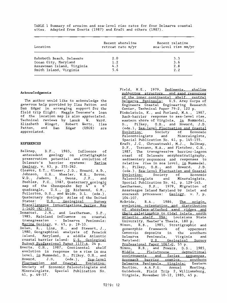
National Academy of Sciences, 1987,Responding to changes in sea level:National Academy Press, Washington, D.C.,148 p.
Owens, J.P., and Denny, C.S., 1979, UpperCenozoic deposits of the central DelmarvaPeninsula, Maryland and Delaware: U.S.Geological Survey Professional Paper1067-A, 28 p.
Riggs, S.R., and Belknap, D.F., UpperCenozoic processes and environments ofcontinental margin sedimentation
eastern United States, in Sheridan, R.E.,and Grow, J.A. (eds.), The Geology ofNorth America. vol. 1-2. The AtlanticContinental Margin. U.S.: GeologicalSociety of America, p. 131-176.
Shideler, G.L., Ludwick, J.C Oertel,G.F., and Finkelstein, K., 1984,Quaternary stratigraphic evolution of thesouthern Delmarva Peninsula coastal zone,Cape Charles, Virginia: GeologicalSociety of America Bulletin. v. 95, p.489-502.
T219: 13