Embed Size (px)
Citation preview
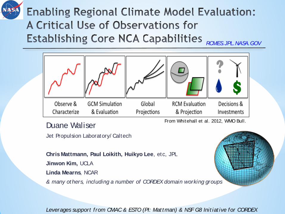
Duane Waliser Jet Propulsion Laboratory/Caltech
Chris Mattmann, Paul Loikith, Huikyo Lee, etc, JPL
Jinwon Kim, UCLA
Linda Mearns, NCAR
& many others, including a number of CORDEX domain working groups
From Whitehall et al. 2012, WMO Bull.
RCMES.JPL.NASA.GOV
Leverages support from CMAC & ESTO (PI: Mattman) & NSF G8 Initiative for CORDEX
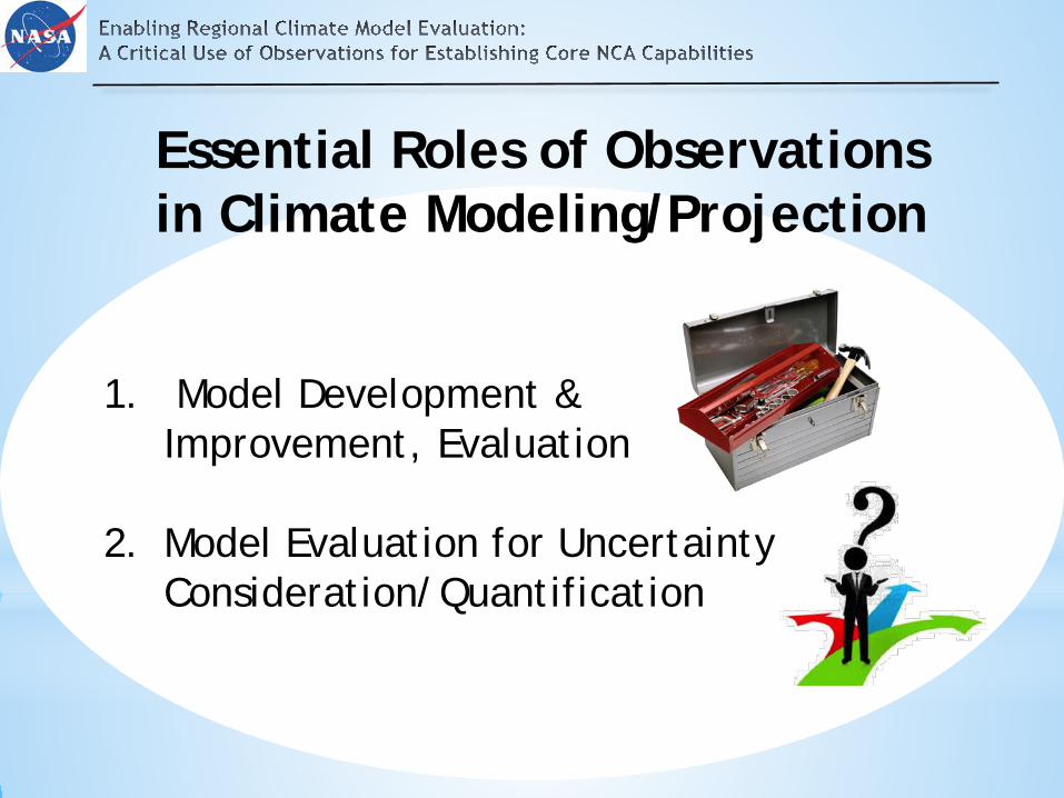
Essential Roles of Observations in Climate Modeling/Projection
1. Model Development & Improvement, Evaluation
2. Model Evaluation for Uncertainty Consideration/Quantification
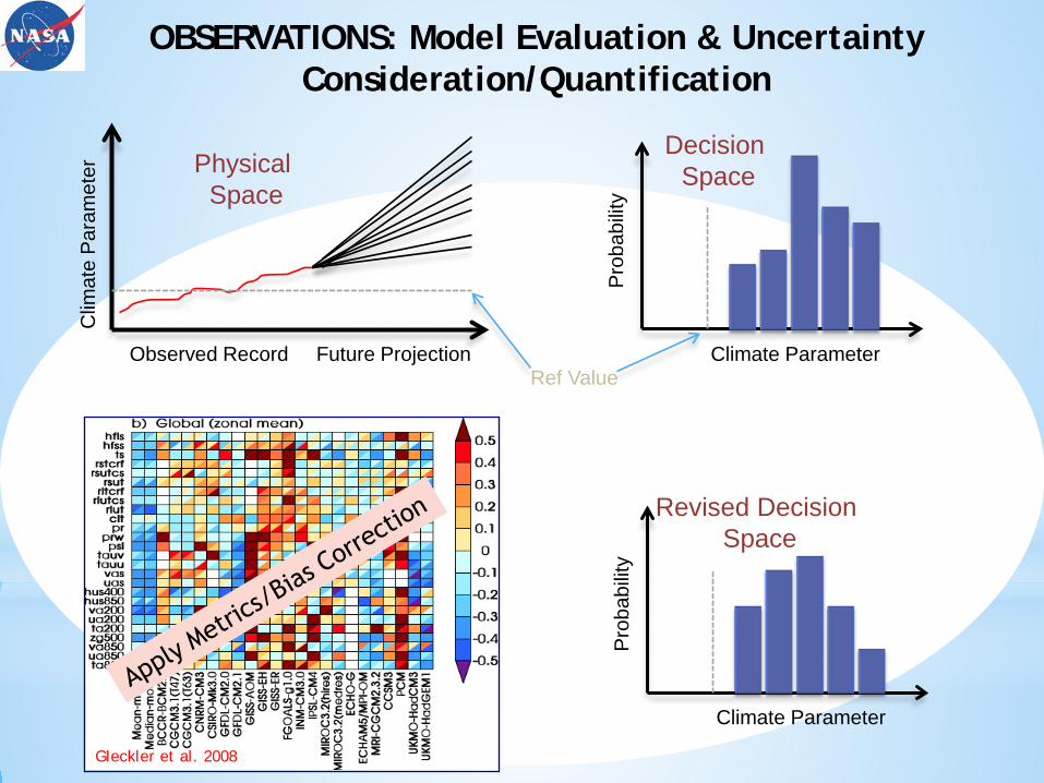
Future Projection Observed Record
Clim
ate
Par
amet
er
Climate Parameter
Pro
babi
lity
Physical Space
Decision Space
OBSERVATIONS: Model Evaluation & Uncertainty Consideration/Quantification
Ref Value
Future Projection Observed Record
Clim
ate
Par
amet
er After “Scoring”
w/ Observations
Climate Parameter
Pro
babi
lity
Revised Decision Space
Gleckler et al. 2008

AMIP I&II obs4MIPs
Clim Metrics Panel CMIP 1&2
xMIPs
Bridging Models and Observations Global Models
CMIP 3&5
ESGF
Systematic Application of Metrics
Systematic coordination
of obs for MIPs
Systematic IT Support &
Infrastructure
Systematic Model
Experiments
Systematic Model Development & Improvement
Global Modeling Observations
2+ Decades of Directed Progress
Closing Gap
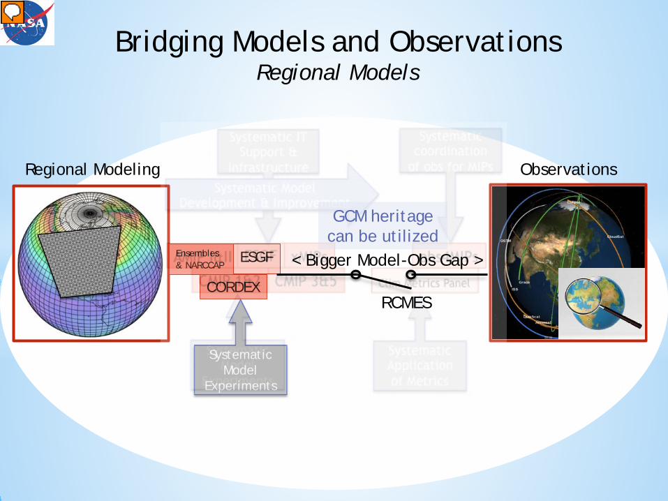
Ensembles & NARCCAP
CORDEX
ESGF
Regional Modeling Observations
Systematic Model
Experiments
GCM heritage can be utilized
Bridging Models and Observations Regional Models
RCMES
< Bigger Model-Obs Gap >
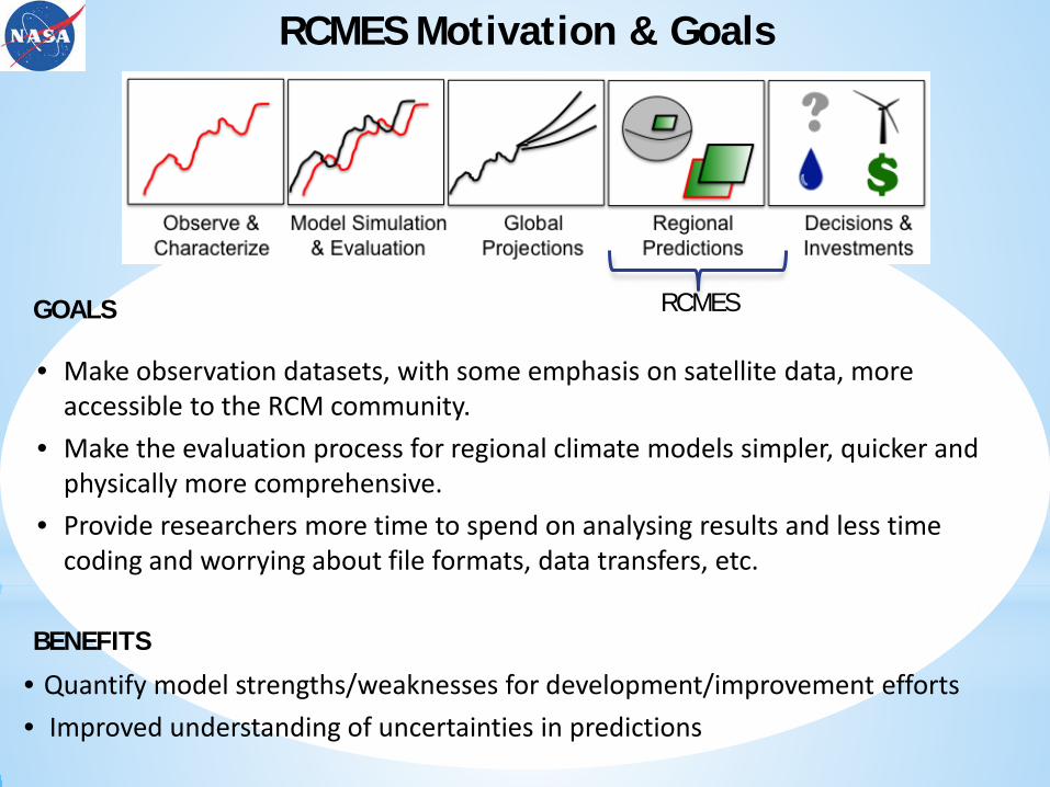
RCMES Motivation & Goals
• Make observation datasets, with some emphasis on satellite data, more accessible to the RCM community.
• Make the evaluation process for regional climate models simpler, quicker and physically more comprehensive.
• Provide researchers more time to spend on analysing results and less time coding and worrying about file formats, data transfers, etc.
• Quantify model strengths/weaknesses for development/improvement efforts • Improved understanding of uncertainties in predictions
GOALS
BENEFITS
RCMES
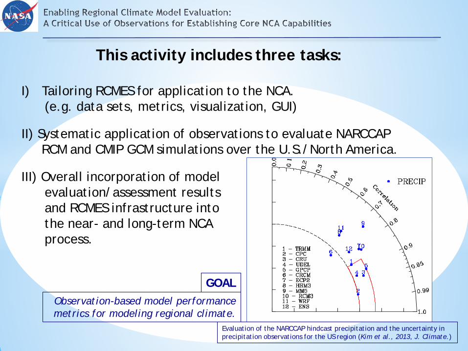
This activity includes three tasks:
I) Tailoring RCMES for application to the NCA. (e.g. data sets, metrics, visualization, GUI)
II) Systematic application of observations to evaluate NARCCAP RCM and CMIP GCM simulations over the U.S./North America.
III) Overall incorporation of model evaluation/assessment results and RCMES infrastructure into the near- and long-term NCA process.
GOAL Observation-based model performance metrics for modeling regional climate.
Evaluation of the NARCCAP hindcast precipitation and the uncertainty in precipitation observations for the US region (Kim et al., 2013, J. Climate.)
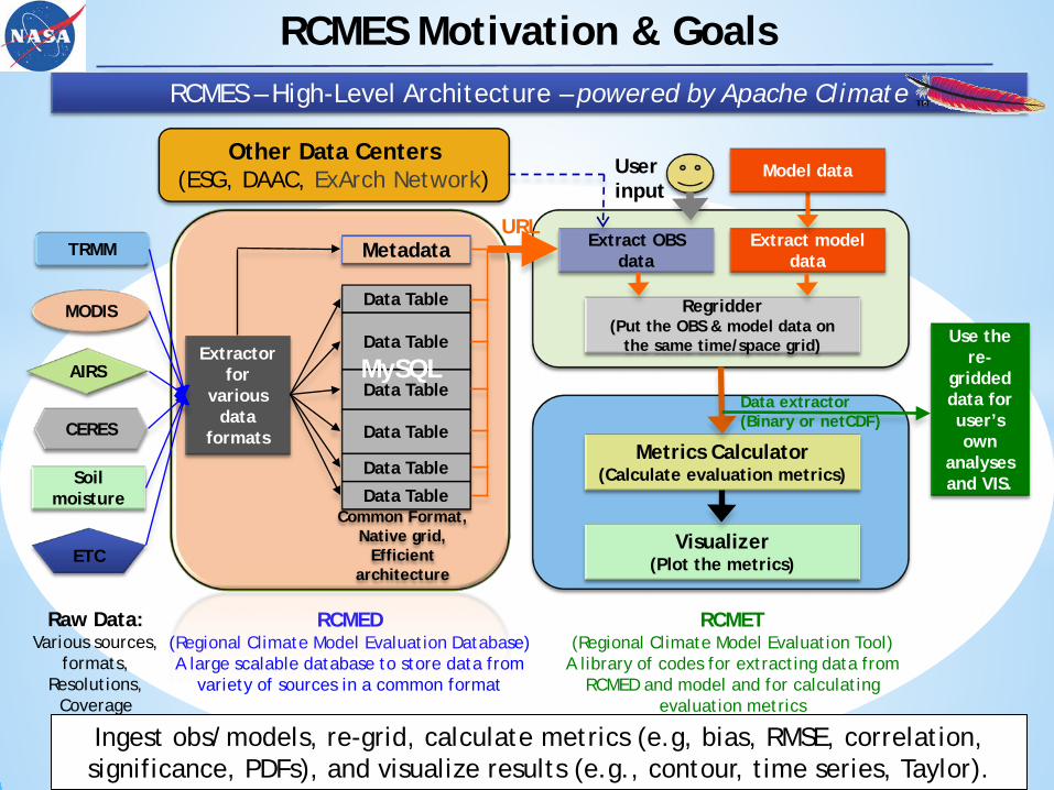
Ingest obs/models, re-grid, calculate metrics (e.g, bias, RMSE, correlation, significance, PDFs), and visualize results (e.g., contour, time series, Taylor).
Raw Data: Various sources,
formats, Resolutions,
Coverage
RCMED (Regional Climate Model Evaluation Database) A large scalable database to store data from
variety of sources in a common format
RCMET (Regional Climate Model Evaluation Tool)
A library of codes for extracting data from RCMED and model and for calculating
evaluation metrics
Metadata
Data Table
Data Table
Data Table
Data Table
Data Table
Data Table Common Format,
Native grid, Efficient
architecture
MySQL Extractor
for various
data formats
TRMM
MODIS
AIRS
CERES
ETC
Soil moisture
Extract OBS data
Extract model data
User input
Regridder (Put the OBS & model data on
the same time/space grid)
Metrics Calculator (Calculate evaluation metrics)
Visualizer (Plot the metrics)
URL
Use the re-
gridded data for user’s own
analyses and VIS.
Data extractor (Binary or netCDF)
Model data Other Data Centers
(ESG, DAAC, ExArch Network)
RCMES – High-Level Architecture – powered by Apache Climate
RCMES Motivation & Goals
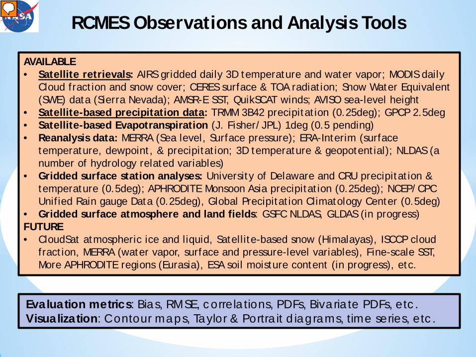
AVAILABLE • Satellite retrievals: AIRS gridded daily 3D temperature and water vapor; MODIS daily
Cloud fraction and snow cover; CERES surface & TOA radiation; Snow Water Equivalent (SWE) data (Sierra Nevada); AMSR-E SST, QuikSCAT winds; AVISO sea-level height
• Satellite-based precipitation data: TRMM 3B42 precipitation (0.25deg); GPCP 2.5deg • Satellite-based Evapotranspiration (J. Fisher/JPL) 1deg (0.5 pending) • Reanalysis data: MERRA (Sea level, Surface pressure); ERA-Interim (surface
temperature, dewpoint, & precipitation; 3D temperature & geopotential); NLDAS (a number of hydrology related variables)
• Gridded surface station analyses: University of Delaware and CRU precipitation & temperature (0.5deg); APHRODITE Monsoon Asia precipitation (0.25deg); NCEP/CPC Unified Rain gauge Data (0.25deg), Global Precipitation Climatology Center (0.5deg)
• Gridded surface atmosphere and land fields: GSFC NLDAS, GLDAS (in progress) FUTURE • CloudSat atmospheric ice and liquid, Satellite-based snow (Himalayas), ISCCP cloud
fraction, MERRA (water vapor, surface and pressure-level variables), Fine-scale SST, More APHRODITE regions (Eurasia), ESA soil moisture content (in progress), etc.
RCMES Observations and Analysis Tools
Evaluation metrics: Bias, RMSE, correlations, PDFs, Bivariate PDFs, etc. Visualization: Contour maps, Taylor & Portrait diagrams, time series, etc.

Easy: Graphical user interface (UI) version. Point and click model evaluation. See demo video at rcmes.jpl.nasa.gov/training/videos. Runs in a virtual machine (VM) environment.
Intermediate: Command line version (also in VM)
Advanced: Check out open source code at: https://github.com/apache/climate.
Requires installation of Python libraries on user’s machine. Allows users to contribute to RCMES development
* All downloads are available at rcmes.jpl.nasa.gov *
RCMES User Interface
3 Ways to Use RCMES
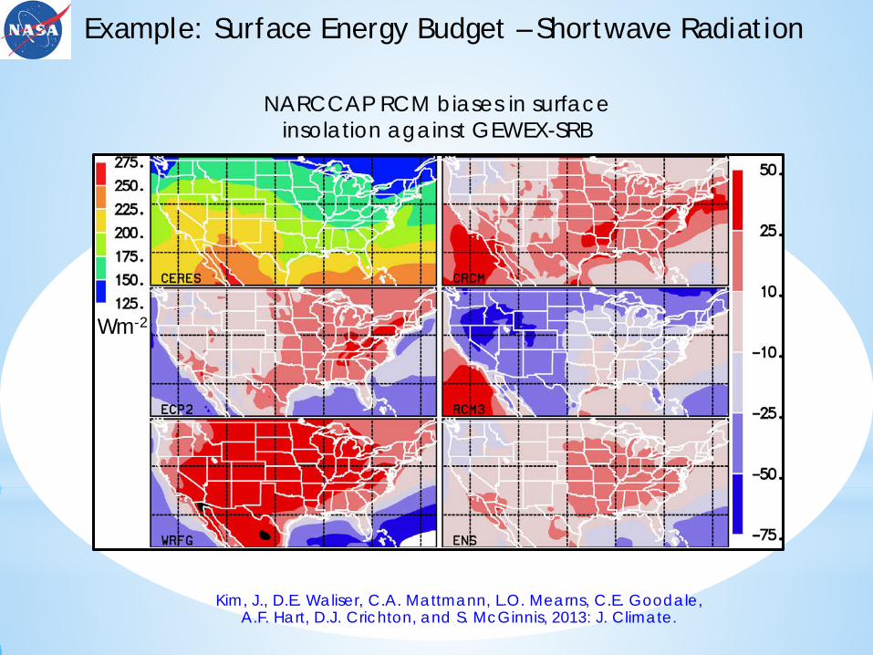
Kim, J., D.E. Waliser, C.A. Mattmann, L.O. Mearns, C.E. Goodale, A.F. Hart, D.J. Crichton, and S. McGinnis, 2013: J. Climate.
NARCCAP RCM biases in surface insolation against GEWEX-SRB
Example: Surface Energy Budget – Shortwave Radiation
Wm-2
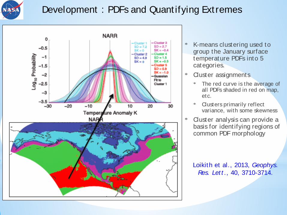
* K-means clustering used to group the January surface temperature PDFs into 5 categories.
* Cluster assignments * The red curve is the average of
all PDFs shaded in red on map, etc.
* Clusters primarily reflect variance, with some skewness
* Cluster analysis can provide a basis for identifying regions of common PDF morphology
Development : PDFs and Quantifying Extremes
Loikith et al., 2013, Geophys. Res. Lett., 40, 3710-3714.
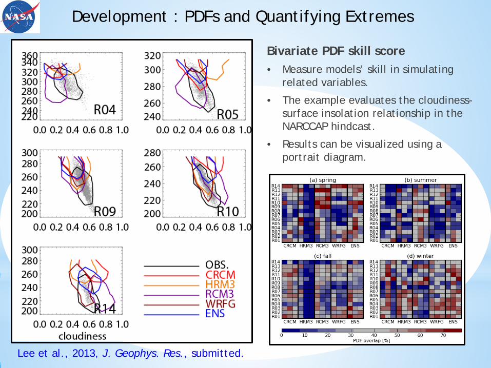
Bivariate PDF skill score • Measure models’ skill in simulating
related variables.
• The example evaluates the cloudiness-surface insolation relationship in the NARCCAP hindcast.
• Results can be visualized using a portrait diagram.
Development : PDFs and Quantifying Extremes
Lee et al., 2013, J. Geophys. Res., submitted.
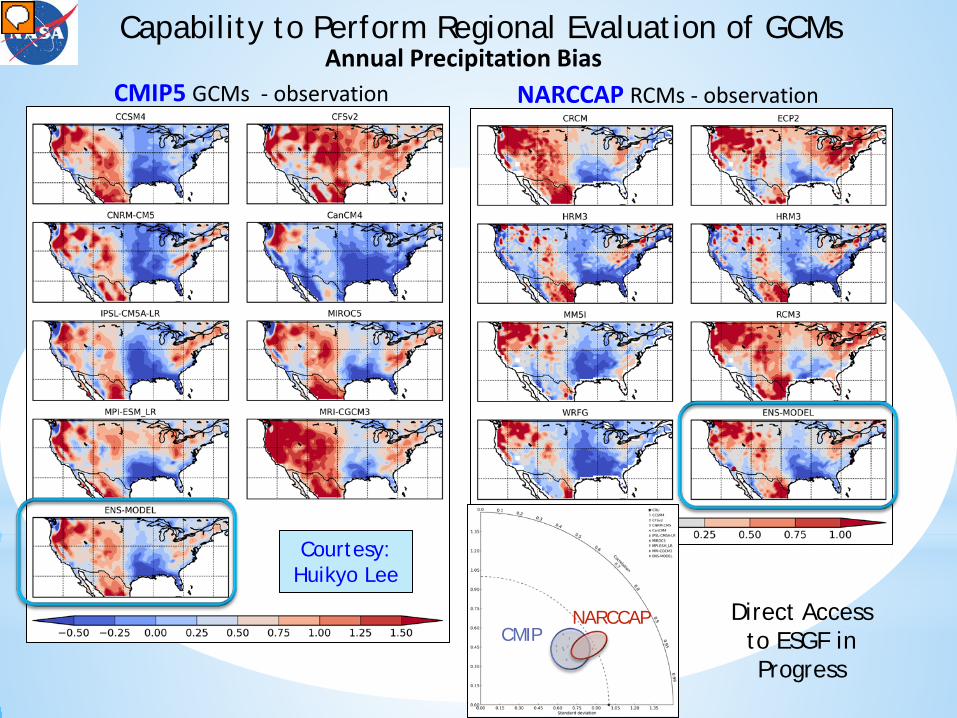
Annual Precipitation Bias CMIP5 GCMs - observation NARCCAP RCMs - observation
Capability to Perform Regional Evaluation of GCMs
Courtesy: Huikyo Lee
CMIP NARCCAP Direct Access
to ESGF in Progress
NARCCAP/NCA Kim, J., D.E. Waliser, C.A. Mattmann, L.O. Mearns, et al., 2013: Evaluation of the surface climatology over
the conterminous United States in the NARCCAP hindcast experiment using RCMES. J. Climate, 26, 5698-5715.
Loikith, P.C., B.R. Lintner, Jinwon Kim, H. Lee, et al., 2013: Classifying reanalysis surface temperature probability density functions (pdfs) over North America with cluster analysis. Geophys. Res. Lett., 40, 3710-3714, doi: 10.1002/grl.50688.
Lee, H., J. Kim, D. Waliser, P. Loikith, et al., 2014: Evaluation of simulation fidelity for precipitation, cloud fraction and insolation in the North American Regional Climate Change Assessment Program (NARCCAP), J. Geophys. Res., submitted.
Loikith, P., J. Kim, H. Lee, B. Lintner, C. Mattmann, J.D. Neelin, D. Waliser, L. Mearns, and S. McGinnis, 2013: Evaluation of surface temperature probability distribution functions in the NARCCAP hindcast experiment. J. Climate, submitted.
Select Related/CORDEX Kim, J., D. Waliser, C. Mattmann, C. Goodale, A. Hart, P. Zimdars, D. Crichton et al., 2013: Evaluation of the
CORDEX-Africa multi-RCM hindcast: systematic model errors. Clim Dyn, DOI 10.1007/s00382-013-1751-7.
Mattmann, C., D. Waliser, Jinwon Kim, C. Goodale, A. Hart, P. Ramirez, D. Crichton, et al., 2013: Cloud computing and virtualization within the Regional Climate Model Evaluation System. Earth Sci. Informatics, doi 10.1007/s12145-013-0126-2.
Other Ongoing Science Analyses - Publications in Preparation P. Loikith – Extremes, skewness & associated circulation features H. Lee – Bayesian ensemble averaging J. Kim – Evaluation of observed and modeled Precipitation over India and Hydrological Cycle
in Western US.
Two formal NCA Inputs (Model Evaluation from Science and IT Perspectives)
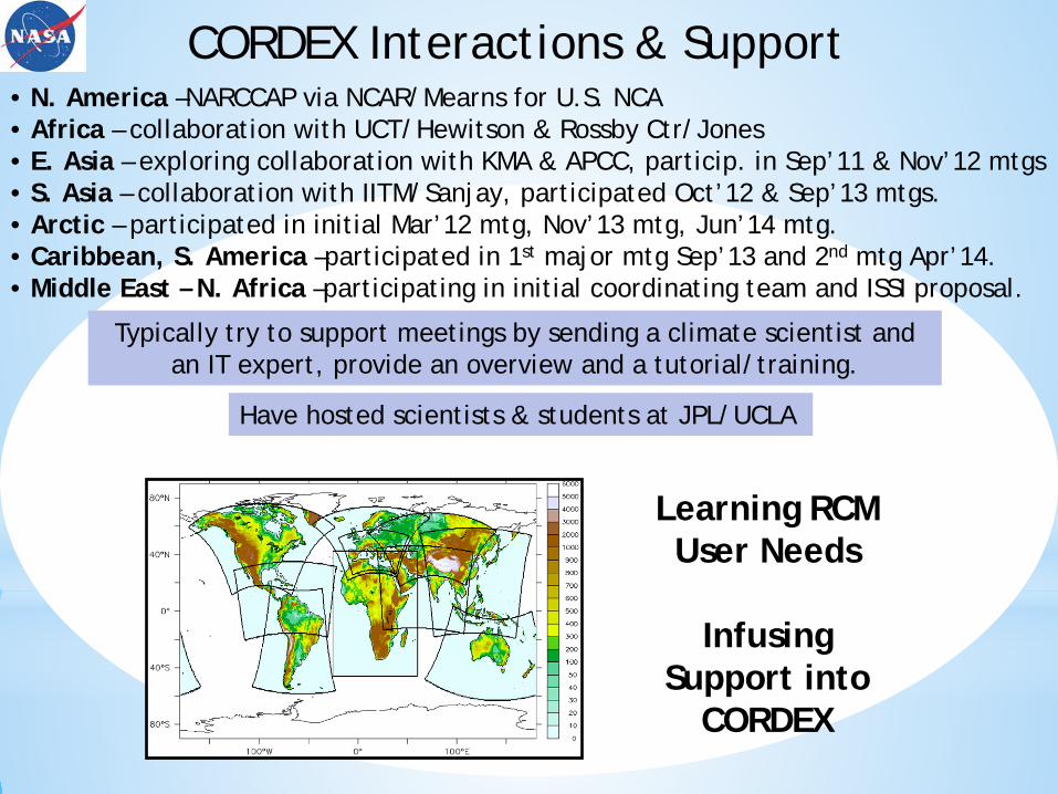
• N. America –NARCCAP via NCAR/Mearns for U.S. NCA • Africa – collaboration with UCT/Hewitson & Rossby Ctr/Jones • E. Asia – exploring collaboration with KMA & APCC, particip. in Sep’11 & Nov’12 mtgs • S. Asia – collaboration with IITM/Sanjay, participated Oct’12 & Sep’13 mtgs. • Arctic – participated in initial Mar’12 mtg, Nov’13 mtg, Jun’14 mtg. • Caribbean, S. America –participated in 1st major mtg Sep’13 and 2nd mtg Apr’14. • Middle East – N. Africa –participating in initial coordinating team and ISSI proposal.
Learning RCM User Needs
Infusing
Support into CORDEX
CORDEX Interactions & Support
Have hosted scientists & students at JPL/UCLA
Typically try to support meetings by sending a climate scientist and an IT expert, provide an overview and a tutorial/training.

Kim Whitehall is a Howard University
graduate student. She spent 2 summers at JPL learning & contributing
to RCMES.
RCMES article in the Oct 2012 issue of the WMO Bulletin highlighting its potential role in WMO’s new Global Framework
for Climate Services
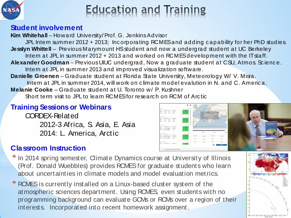
* In 2014 spring semester, Climate Dynamics course at University of Illinois (Prof. Donald Wuebbles) provides RCMES for graduate students who learn about uncertainties in climate models and model evaluation metrics.
* RCMES is currently installed on a Linux-based cluster system of the atmospheric sciences department. Using RCMES, even students with no programming background can evaluate GCMs or RCMs over a region of their interests. Incorporated into recent homework assignment.
Student involvement Kim Whitehall – Howard University/Prof. G. Jenkins Advisor JPL Intern summer 2012 + 2013; Incorporating RCMES and adding capability for her PhD studies. Jesslyn Whittell – Previous Marymount HS student and now a undergrad student at UC Berkeley Intern at JPL in summer 2012 + 2013 and worked on RCMES development with the IT staff. Alexander Goodman – Previous UIUC undergrad, Now a graduate student at CSU, Atmos. Science. Intern at JPL in summer 2013 and improved visualization software. Danielle Groenen – Graduate student at Florida State University, Meteorology W/ V. Misra. Intern at JPL in summer 2014, will work on climate model evalution in N. and C. America. Melanie Cooke – Graduate student at U. Toronto w/ P. Kushner Short term visit to JPL to learn RCMES for research on RCM of Arctic
Classroom Instruction
Training Sessions or Webinars CORDEX-Related 2012-3 Africa, S. Asia, E. Asia 2014: L. America, Arctic
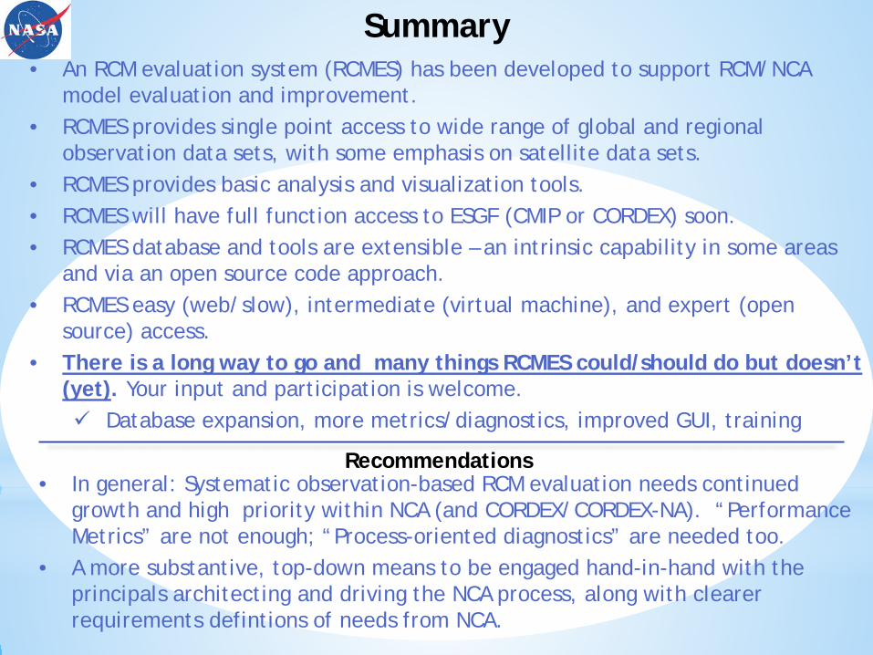
Summary • An RCM evaluation system (RCMES) has been developed to support RCM/NCA
model evaluation and improvement. • RCMES provides single point access to wide range of global and regional
observation data sets, with some emphasis on satellite data sets. • RCMES provides basic analysis and visualization tools. • RCMES will have full function access to ESGF (CMIP or CORDEX) soon. • RCMES database and tools are extensible – an intrinsic capability in some areas
and via an open source code approach. • RCMES easy (web/slow), intermediate (virtual machine), and expert (open
source) access. • There is a long way to go and many things RCMES could/should do but doesn’t
(yet). Your input and participation is welcome. Database expansion, more metrics/diagnostics, improved GUI, training
• In general: Systematic observation-based RCM evaluation needs continued
growth and high priority within NCA (and CORDEX/CORDEX-NA). “Performance Metrics” are not enough; “Process-oriented diagnostics” are needed too.
• A more substantive, top-down means to be engaged hand-in-hand with the principals architecting and driving the NCA process, along with clearer requirements defintions of needs from NCA.
Recommendations
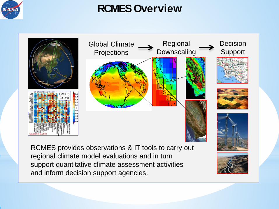
Global Climate Projections
Regional Downscaling
Decision Support
RCMES provides observations & IT tools to carry out regional climate model evaluations and in turn support quantitative climate assessment activities and inform decision support agencies.
RCMES Overview