Embed Size (px)
Citation preview
1
FROM RIVERS TO SOUNDS
IN THE BERTIE WATER CRESCENT
A WATER-BASED VISION FOR SUSTAINABLE
ECO-TOURISM AND ENVIRONMENTAL EDUCATION
BERTIE COUNTY, NC
FROM RIVERS TO SOUNDS
A REPORT OF THE NORTH CAROLINA LAND OF WATER (NC LOW)
www.nclandofwater.org
December 21, 2018
2
FROM RIVERS TO SOUNDS
IN THE BERTIE WATER CRESCENT
A WATER-BASED VISION FOR SUSTAINABLE
ECO-TOURISM AND ENVIRONMENTAL EDUCATION
BERTIE COUNTY, NC
NORTH CAROLINA LAND OF WATER (NC LOW) www.nclandofwater.org
NC LOW TEAM Dr. Stanley Riggs: North Carolina Land of Water (NC LOW) Mr. David Hodges: Good Consulting Service, LLC Dr. Robert Christian: North Carolina Land of Water (NC LOW) Dr. David Mallinson: ECU Department of Geological Sciences Ms. Dorothea Ames: North Carolina Land of Water (NC LOW) Ms. Karen Clough: North Carolina Land of Water (NC LOW)
FUNDED BY
TOWN OF WINDSOR BERTIE COUNTY
KENAN INSTITUTE OF ENGINEERING, TECHNOLOGY, AND SCIENCE EAST CAROLINA UNIVERSITY
December 21, 2018
COVER PHOTOGRAPH: Left panel is the Hoggard Mill Road small boat launch built by the Town of Windsor on the bank of the black-water Cashie River. Photograph is by S. Riggs. Right panel is looking north along the sandy beach of Albemarle Sound in Bertie County’s 137 acre property known as “A Tall Glass of Water”. Photograph is by S. Sauer.
3
FROM RIVERS TO SOUNDS IN THE BERTIE WATER CRESCENT
TABLE OF CONTENTS INTRODUCTION ……………………………………………………………………….. 5 DEVELOPING REGIONAL STORIES FOR ECO-TOURISM ………………… 8 THE BERTIE COASTAL SYSTEM AND ECO-TOURISM …………………… 9 “WATER HUBS” OF THE “BERTIE WATER CRESCENT” …………………………. 13 WATER HUB 1. WINDSOR ON THE CASHIE RIVER ……………………….. 14
Advanced Development Stage 14
Assets of the Hoggard Mill Road Cashie River Site 19
Assets of the Windsor Waterfront Park 21
Assets of the Roanoke-Cashie River Center 24
Assets of the Cashie River Campgroud at Elm Street 26
Recommendations for the Hoggard Mill Cashie River Site 27
Recommendations for the Windsor Waterfront Park 28
Recommendation for the Roanoke-Cashie River Center 28
WATER HUB 2. SANS SOUCI ON THE LOWER CASHIE RIVER ESTUARY 29
Intermediate Development Stage 29
Recommendations for the Sans Souci Water Hub 32
WATER HUB 3. SALMON CREEK RIVERS TO SOUNDS …………………… 35
Early Development Stage 35
Bertie County’s “Tall Glass of Water” 38
North Carolina State Park’s Salmon Creek Natural Area 39
` Assets for the Salmon Creek Natural Area 41
Bal Gra Potential Coastal Land Trust Site 41
Recommendations for the Salmon Creek Rivers to Sounds Water Hub ….. 43
4
WATER HUB 4. WEEPING MARY ON THE ROANOKE RIVER ……………. 46
Early Development Stage 46
Assets of the Weeping Mary on the Roanoke Water Hub 51
Recommendations for the Weeping Mary on the Roanoke Water Hub 52
WATER HUB 5. COLERAIN ON THE CHOWAN RIVER ESTUARY ……….. 55
Future Development Stage 55
Colerain Swamp Kayak Trail 58
Northern Chowan River Kayak Trail 61
Wicomoco Bluffs Trail 62
Small Boat Sailing Camp 65
Herring Fisheries History 66
Native American History 66
Future Options for the Colerain Water Hub 67
SUMMARY: FROM RIVERS TO SOUNDS …………………………………………… 69
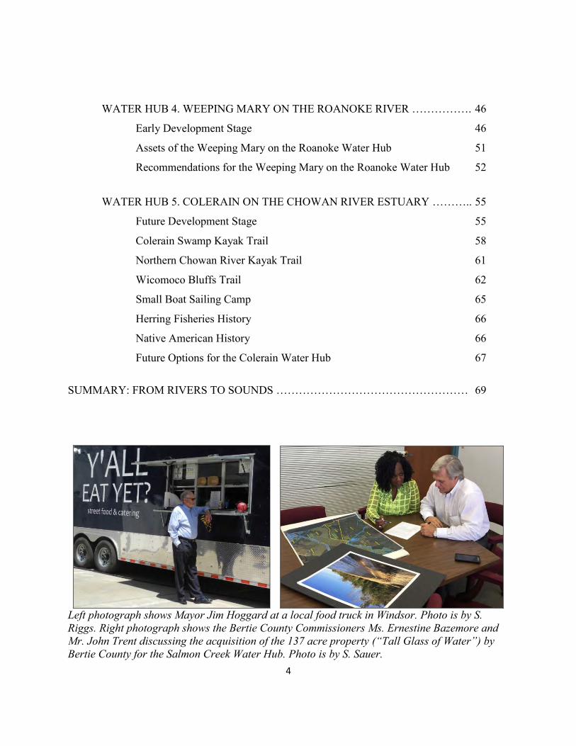
Left photograph shows Mayor Jim Hoggard at a local food truck in Windsor. Photo is by S. Riggs. Right photograph shows the Bertie County Commissioners Ms. Ernestine Bazemore and Mr. John Trent discussing the acquisition of the 137 acre property (“Tall Glass of Water”) by Bertie County for the Salmon Creek Water Hub. Photo is by S. Sauer.
5
INTRODUCTION The Bertie Peninsula is a long and broad finger of land that extends southeast from the Virginia-North Carolina border into the Albemarle Sound (Figure 1). The peninsula is bounded by the Roanoke River system along the southwest and south shores and the Chowan River system along the east shore. The lower portions of both river valleys are being flooded by the ongoing processes of rising sea level to produce the Albemarle Sound and Chowan River estuaries, respectively. The Bertie Peninsula contains a descending scale of ever smaller tributary drainage basins that flow into the larger Roanoke and Chowan trunk rivers to form the “Bertie Water Crescent”. These smaller drainage systems range from mid-scale Cashie River and Salmon Creek to the small-scale of Black Walnut and Cashoke swamps, and the very small, ephemeral streams that form steep canyons riming the highland bluffs. Thus, the “Bertie Water Crescent” is a complex of different kinds of water drainage systems that are like a series of living organisms, continually interacting with each other and forming a diverse system of associated landscapes and complex eco-systems. Additionally, each of these waterscape and landscape components continuously respond to changing atmospheric dynamics of storm events with their extremes of wind and rain. This dramatic setting of natural resources defines Bertie County with a world-class water system that can be utilized as a foundation for sustainable economic development. Bertie County is blessed with a treasure trove of natural resources consisting of a diverse waterscape that has dissected a unique landscape, both of which dictated the long and rich cultural history. The northern portion is a high terrace (45 to 80 plus feet above sea level) where the towns of Roxobel, Kelford, Lewiston-Woodville, Aulander, Powellsville, and Askewville are located (Figure 2). This upper terrace also forms the interstream divide between the south-flowing drainage system of Bertie County and the north-flowing drainage that dominates Hertford County and has been truncated on the east by the Chowan River estuary forming the north-south oriented, high shoreline bluffs. The Cashie River system lies totally within the boundaries of Bertie County with its headwaters incised into the uplands of the upper terrace. The Cashie River flows down slope onto an intermediate terrace (elevations of 20 to 45 feet above sea level) where most of the town of Windsor is located. South of Windsor, the Cashie River is at sea level resulting in a broad, meandering channel with a wide swamp-forest floodplain that flows into the Roanoke River. The entire western and southern portion of Bertie County is low (0 to 20 feet above sea level) and consists of a series of paleo-braid plains and the primary floodplain of the Roanoke River that empties into the estuarine waters of Batchelor Bay at the western end of Albemarle Sound. Albemarle Sound formed as modern sea level rose and flooded the eastern portion of the Paleo-Roanoke River valley.
6
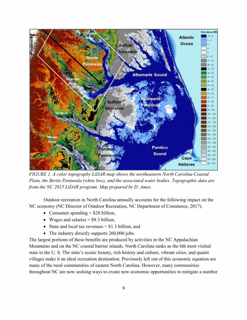
FIGURE 1. A color topography LiDAR map shows the northeastern North Carolina Coastal Plain, the Bertie Peninsula (white box), and the associated water bodies. Topographic data are from the NC 2015 LiDAR program. Map prepared by D. Ames. Outdoor recreation in North Carolina annually accounts for the following impact on the NC economy (NC Director of Outdoor Recreation, NC Department of Commerce, 2017).
Consumer spending = $28 billion, Wages and salaries = $8.3 billion, State and local tax revenues = $1.3 billion, and The industry directly supports 260,000 jobs.
The largest portions of these benefits are produced by activities in the NC Appalachian Mountains and on the NC coastal barrier islands. North Carolina ranks as the 6th most visited state in the U. S. The state’s scenic beauty, rich history and culture, vibrant cities, and quaint villages make it an ideal recreation destination. Previously left out of this economic equation are many of the rural communities of eastern North Carolina. However, many communities throughout NC are now seeking ways to create new economic opportunities to mitigate a number
7
of challenges including loss of jobs, population decline, high poverty rates, empty buildings, and crumbling infrastructure.
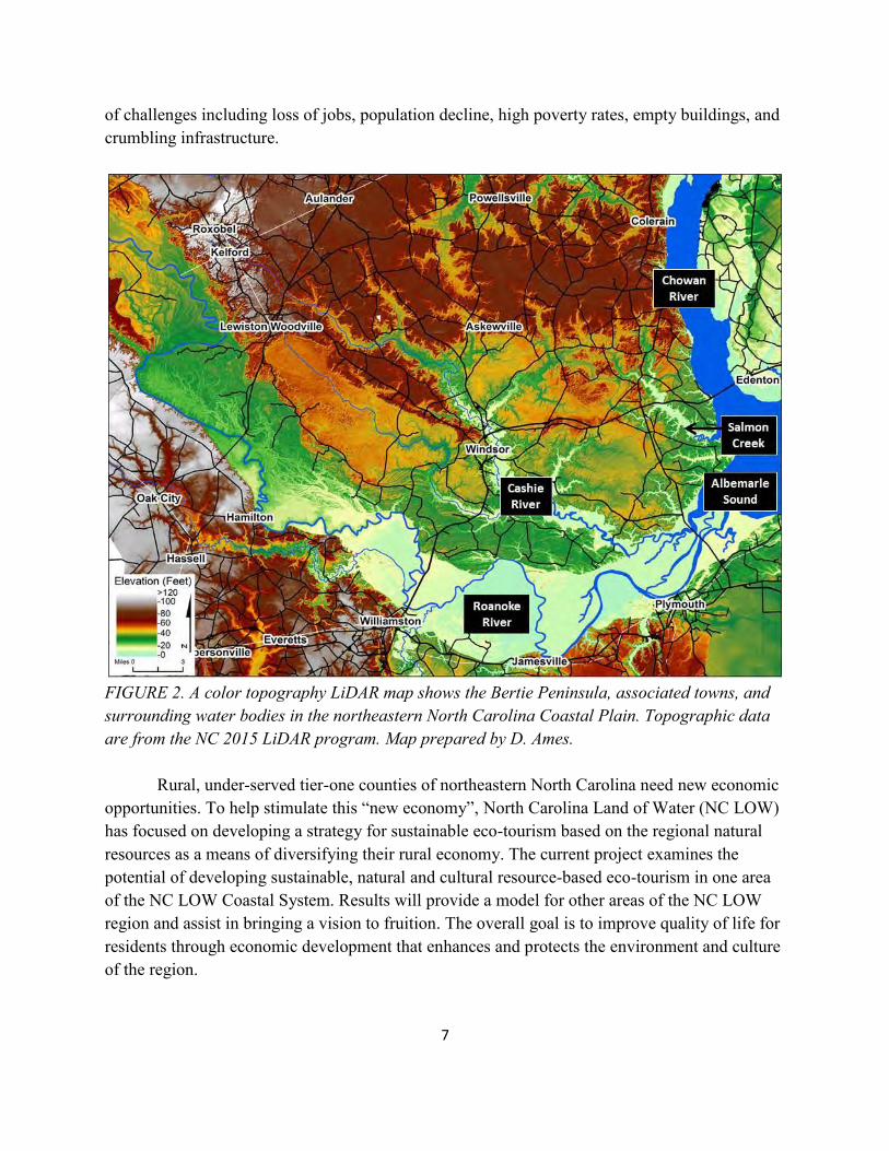
FIGURE 2. A color topography LiDAR map shows the Bertie Peninsula, associated towns, and surrounding water bodies in the northeastern North Carolina Coastal Plain. Topographic data are from the NC 2015 LiDAR program. Map prepared by D. Ames. Rural, under-served tier-one counties of northeastern North Carolina need new economic opportunities. To help stimulate this “new economy”, North Carolina Land of Water (NC LOW) has focused on developing a strategy for sustainable eco-tourism based on the regional natural resources as a means of diversifying their rural economy. The current project examines the potential of developing sustainable, natural and cultural resource-based eco-tourism in one area of the NC LOW Coastal System. Results will provide a model for other areas of the NC LOW region and assist in bringing a vision to fruition. The overall goal is to improve quality of life for residents through economic development that enhances and protects the environment and culture of the region.
8
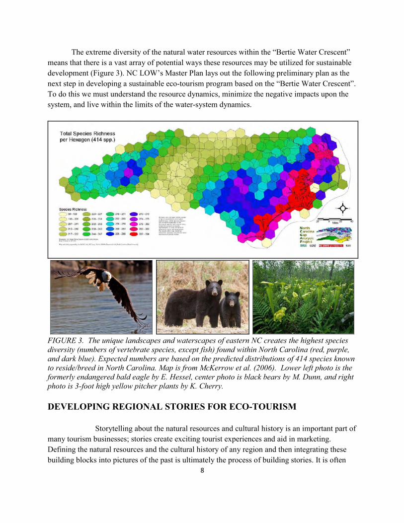
The extreme diversity of the natural water resources within the “Bertie Water Crescent” means that there is a vast array of potential ways these resources may be utilized for sustainable development (Figure 3). NC LOW’s Master Plan lays out the following preliminary plan as the next step in developing a sustainable eco-tourism program based on the “Bertie Water Crescent”. To do this we must understand the resource dynamics, minimize the negative impacts upon the system, and live within the limits of the water-system dynamics.
FIGURE 3. The unique landscapes and waterscapes of eastern NC creates the highest species diversity (numbers of vertebrate species, except fish) found within North Carolina (red, purple, and dark blue). Expected numbers are based on the predicted distributions of 414 species known to reside/breed in North Carolina. Map is from McKerrow et al. (2006). Lower left photo is the formerly endangered bald eagle by E. Hessel, center photo is black bears by M. Dunn, and right photo is 3-foot high yellow pitcher plants by K. Cherry.
DEVELOPING REGIONAL STORIES FOR ECO-TOURISM Storytelling about the natural resources and cultural history is an important part of many tourism businesses; stories create exciting tourist experiences and aid in marketing. Defining the natural resources and the cultural history of any region and then integrating these building blocks into pictures of the past is ultimately the process of building stories. It is often
9
the telling of these stories, along with recreational interests, that make people want to visit a region as tourists. Awesome stories are waiting to be told about North Carolina’s ancient climates when the world was in an icebox with massive continental ice sheets covering two-thirds of North America, when storms were an order of magnitude bigger than modern storms causing the gentle rivers of today to be dominated by massive floodwaters, and Wooly Mammoths roamed the tundra and boreal forests of eastern NC. We create stories about the Native Americans who first inhabited NC, about the colonization and exploration by the Europeans, and the enslavement of Africans who dug our canals and built our plantations, about wars of freedom, and about the taming of a wilderness by ditching and draining the land and damming the rivers. And stories are built around the hunting and fishing, native fauna and flora, and the beaches and estuaries of the Outer and Inner Banks of NC. Stories about the natural resources and cultural history are critically important for eco-tourism businesses. THE BERTIE COASTAL SYSTEM AND ECO-TOURISM Development of paddle trails as well as waterfront facilities and programs would build upon the strategic business clusters identified by the Bertie County Board of Commissioners, which include adventure and eco-tourism market segments. Capitalizing on the wildlife resources for hunting and fishing and natural resources for eco-tourism around birding, boating, paddling, hiking, and touring would offer local entrepreneurs the opportunity to create small businesses to support recreation and eco-tourism activities. The natural resources and cultural history of Bertie County provide a great opportunity for continued development of outdoor recreation and tourism. In the 2018 Bertie County Comprehensive Recreation Plan, public input showed overwhelming support for outdoor recreation and tourism. Further development of facilities and programs is needed by increasing partnerships with agencies including the Roanoke River Wildlife Refuge, Roanoke-Cashie River Center, The Nature Conservancy, NC State Parks, NC Wildlife Resources Commission, and numerous other local and regional resource related and land holding organizations as indicated in Table 1.
The concept for developing eco-lodges could be done with public/private partnerships to produce sustainable eco-tourism built around the “world class” natural resources and cultural heritage in the Bertie County region. For example, this program could be a simplified variation of the Pisgah Inn at top of the Blue Ridge Parkway or the Grandfather Mountain Lodge. Such eco-lodges would provide critical lodging and restaurants to support the National Water Trail system. In the Bertie County region this partnership program would build on the water-based resources of the Bertie Water Crescent and potential designation as a National Water Trail System by the US National Park Service. The public/private partnership could be composed of public agencies and organizations (County, State, and Federal) to initiate and fund critical start-
10
ups concerning specific eco-lodges and associated educational and recreational centers. These start-ups could then be contracted to private groups to implement the programs and run the eco-lodges.
TABLE 1. PUBLIC LANDS OF THE “BERTIE WATER CRESCENT” INCLUDING THE ROANOKE & CHOWAN RIVERS, ALBEMARLE SOUND, & ASSOCIATED BLACK-WATER TRIBUTARY STREAMS 1. US Roanoke River National Wildlife Refuge A. Lower Roanoke River 84.89 km2 20,978 acres 2. NC Wildlife Resources Commission Game Lands A. Lower Roanoke River 31,704 B. Upper Roanoke River 10,253 C. Cashie-Roquist Rivers 3,884 D. Colerain Chowan River Swamp 367 E. Northern Chowan River Swamp 32,203 3. The Nature Conservancy A. Lower Roanoke River 20,976 4. NC State Parks: Salmon Creek Natural Area A. Albemarle Sound & Salmon Creek 995 5. Bertie County A. Cashie River 162 B. Albemarle Sound 137 6. Town of Windsor: Cashie River 93 7. NC Coastal Land Trust: Albemarle Sound (pending) 300 TOTAL PUBLIC LANDS* = MORE THAN 122,052 ACRES or = 191 MI2 * Plus small amounts of scattered wetlands owned by other Bertie towns and county, plus
other state agencies and non-profit organizations. These unique water bodies and much of the adjacent floodplain swamplands (Figure 4) are already in the public domain. The goals of this partnership program are to:
increase the accessibility of these incredible resources to specific public groups; develop new economic opportunities for an economically distressed Tier 1, rural
region; provide jobs for the local communities and residents; increase the protection of natural resources and improve environmental
stewardship through education and experiential understanding; and upgrade the quality of life and lure new businesses to the region.
The “Bertie Water Crescent” is bounded by the southeast flowing Roanoke River from Roanoke Rapids and the south flowing Chowan River from the NC-VA border, both flowing into the
11
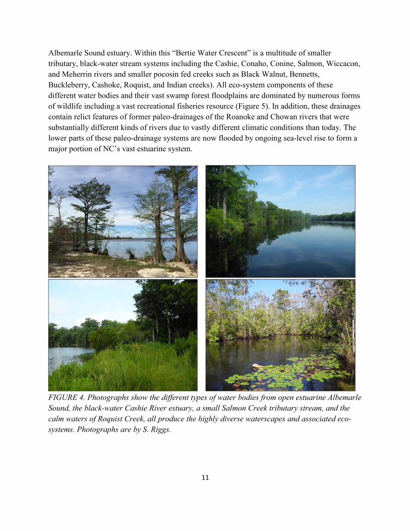
Albemarle Sound estuary. Within this “Bertie Water Crescent” is a multitude of smaller tributary, black-water stream systems including the Cashie, Conaho, Conine, Salmon, Wiccacon, and Meherrin rivers and smaller pocosin fed creeks such as Black Walnut, Bennetts, Buckleberry, Cashoke, Roquist, and Indian creeks). All eco-system components of these different water bodies and their vast swamp forest floodplains are dominated by numerous forms of wildlife including a vast recreational fisheries resource (Figure 5). In addition, these drainages contain relict features of former paleo-drainages of the Roanoke and Chowan rivers that were substantially different kinds of rivers due to vastly different climatic conditions than today. The lower parts of these paleo-drainage systems are now flooded by ongoing sea-level rise to form a major portion of NC’s vast estuarine system.
FIGURE 4. Photographs show the different types of water bodies from open estuarine Albemarle Sound, the black-water Cashie River estuary, a small Salmon Creek tributary stream, and the calm waters of Roquist Creek, all produce the highly diverse waterscapes and associated eco-systems. Photographs are by S. Riggs.
12
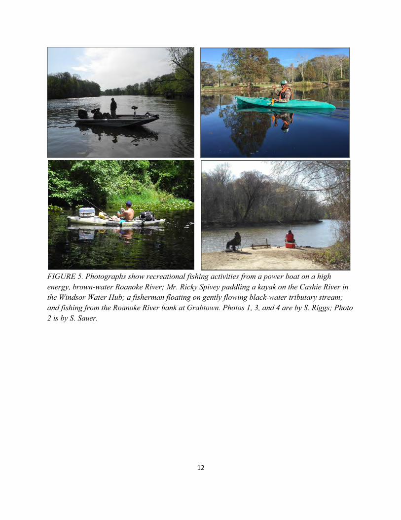
FIGURE 5. Photographs show recreational fishing activities from a power boat on a high energy, brown-water Roanoke River; Mr. Ricky Spivey paddling a kayak on the Cashie River in the Windsor Water Hub; a fisherman floating on gently flowing black-water tributary stream; and fishing from the Roanoke River bank at Grabtown. Photos 1, 3, and 4 are by S. Riggs; Photo 2 is by S. Sauer.
13
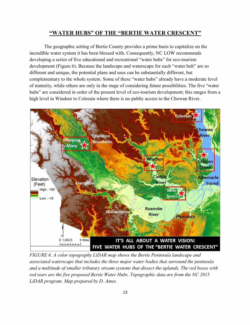
“WATER HUBS” OF THE “BERTIE WATER CRESCENT” The geographic setting of Bertie County provides a prime basis to capitalize on the incredible water system it has been blessed with. Consequently, NC LOW recommends developing a series of five educational and recreational “water hubs” for eco-tourism development (Figure 6). Because the landscape and waterscape for each “water hub” are so different and unique, the potential plans and uses can be substantially different, but complementary to the whole system. Some of these “water hubs” already have a moderate level of maturity, while others are only in the stage of considering future possibilities. The five “water hubs” are considered in order of the present level of eco-tourism development; this ranges from a high level in Windsor to Colerain where there is no public access to the Chowan River.
FIGURE 6. A color topography LiDAR map shows the Bertie Peninsula landscape and associated waterscape that includes the three major water bodies that surround the peninsula and a multitude of smaller tributary stream systems that dissect the uplands. The red boxes with red stars are the five proposed Bertie Water Hubs. Topographic data are from the NC 2015 LiDAR program. Map prepared by D. Ames.
14
WATER HUB 1. WINDSOR ON THE CASHIE RIVER Advanced Development Stage The Town of Windsor lies at the transition zone of the Cashie River. This zone occurs where the steep, upstream headwater branches meet the flat, broad estuarine segment that flows into and is controlled by the water dynamics of the lower Roanoke River and Albemarle Sound (Figure 7). Since Windsor is located at the transition zone between the upper and lower Cashie River segments, the town is at sea level. Upstream the river has a narrow channel, small floodplain, and a steep gradient. The lower segment of the Cashie River system is a wide, black-water, navigable section with a broad and active floodplain swamp forest. Consequently, the town receives flood impacts from both upstream discharge and downstream storm and flood surges. Due to Windsor’s historic significance and role as the economic center for Bertie County, the residents have a strong desire to plan for the town’s future with the ongoing rise in sea level and increase in frequency and intensity of storms. More frequent and intense water level events on the Cashie River will increase flooding within the lowlands of the Windsor waterfront. Windsor has experienced extreme damage from four major flood events in the last two decades, including Hurricane Floyd (1999), Tropical Storm Nicole (2010) and the consecutive events of Tropical Storm Julia and Hurricane Matthew (2016) (Figure 8). The apparent recent increase in frequency of flooding events has led Windsor’s residents to realize that redevelopment of the Cashie River Waterfront Park is an important initiative. The redevelopment effort should minimize impacts of flooding, build on the natural resources of the river system, and focus on potential opportunities to increase sustainable eco-tourism. Implementation of this progressive approach has already led to a recognized leadership role in developing and promoting the regions natural resources and its cultural history. Following are two lists; the first contains the already completed assets and the second itemizes the proposed recommendations for future development.
15
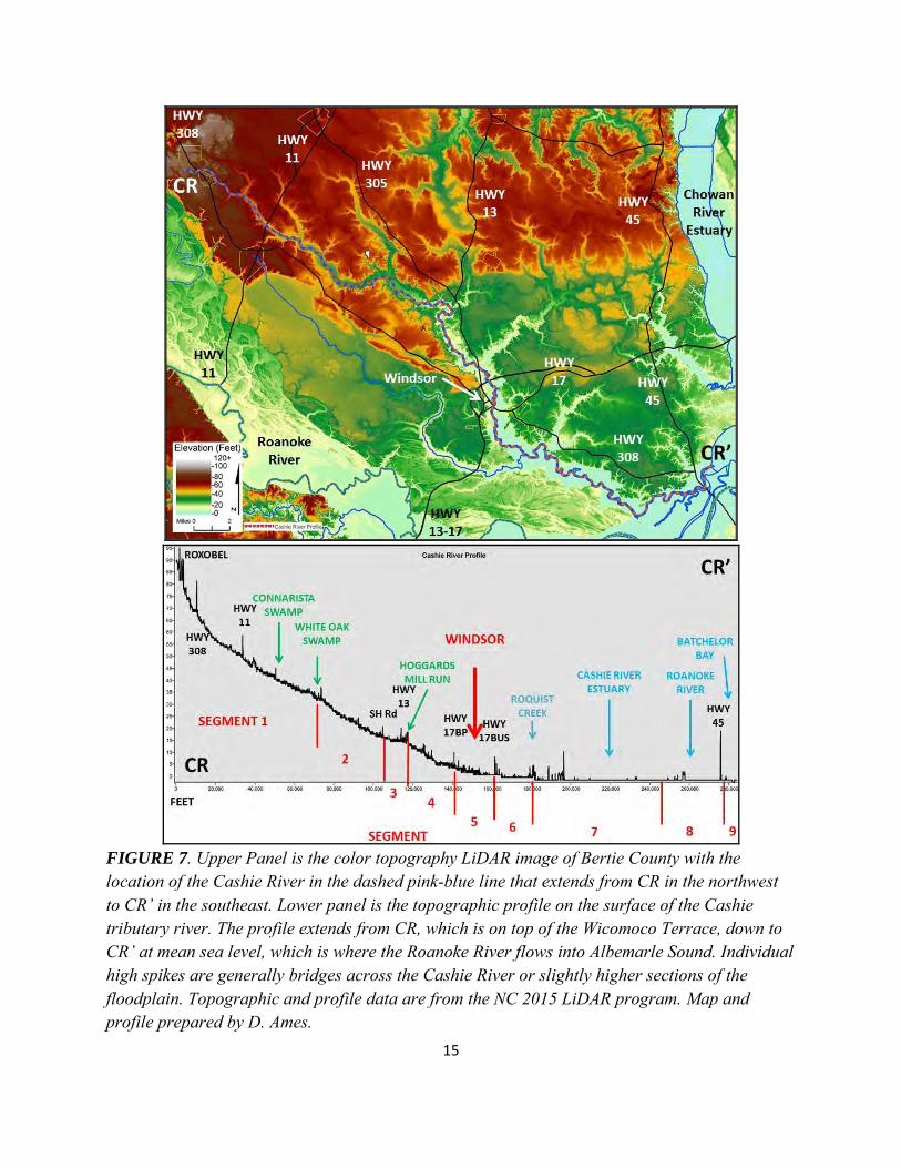
FIGURE 7. Upper Panel is the color topography LiDAR image of Bertie County with the location of the Cashie River in the dashed pink-blue line that extends from CR in the northwest to CR’ in the southeast. Lower panel is the topographic profile on the surface of the Cashie tributary river. The profile extends from CR, which is on top of the Wicomoco Terrace, down to CR’ at mean sea level, which is where the Roanoke River flows into Albemarle Sound. Individual high spikes are generally bridges across the Cashie River or slightly higher sections of the floodplain. Topographic and profile data are from the NC 2015 LiDAR program. Map and profile prepared by D. Ames.
16
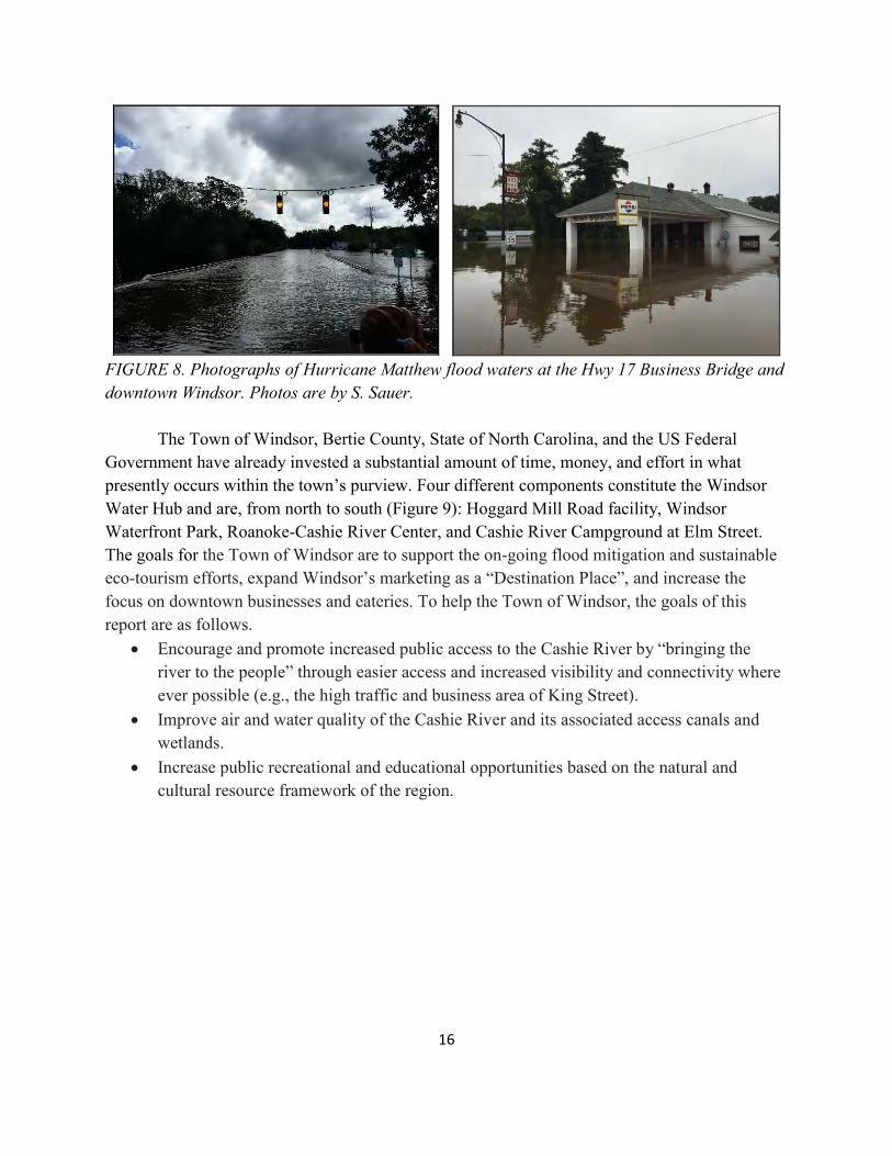
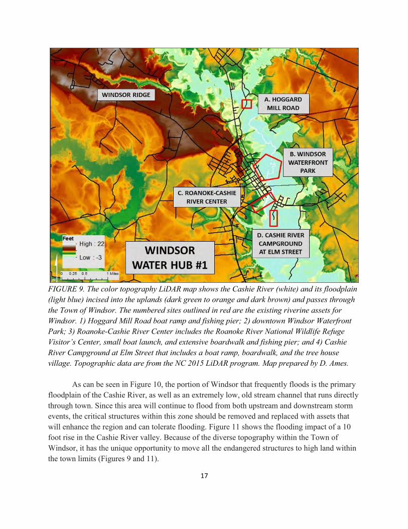
FIGURE 8. Photographs of Hurricane Matthew flood waters at the Hwy 17 Business Bridge and downtown Windsor. Photos are by S. Sauer. The Town of Windsor, Bertie County, State of North Carolina, and the US Federal Government have already invested a substantial amount of time, money, and effort in what presently occurs within the town’s purview. Four different components constitute the Windsor Water Hub and are, from north to south (Figure 9): Hoggard Mill Road facility, Windsor Waterfront Park, Roanoke-Cashie River Center, and Cashie River Campground at Elm Street. The goals for the Town of Windsor are to support the on-going flood mitigation and sustainable eco-tourism efforts, expand Windsor’s marketing as a “Destination Place”, and increase the focus on downtown businesses and eateries. To help the Town of Windsor, the goals of this report are as follows.
Encourage and promote increased public access to the Cashie River by “bringing the river to the people” through easier access and increased visibility and connectivity where ever possible (e.g., the high traffic and business area of King Street).
Improve air and water quality of the Cashie River and its associated access canals and wetlands.
Increase public recreational and educational opportunities based on the natural and cultural resource framework of the region.
17
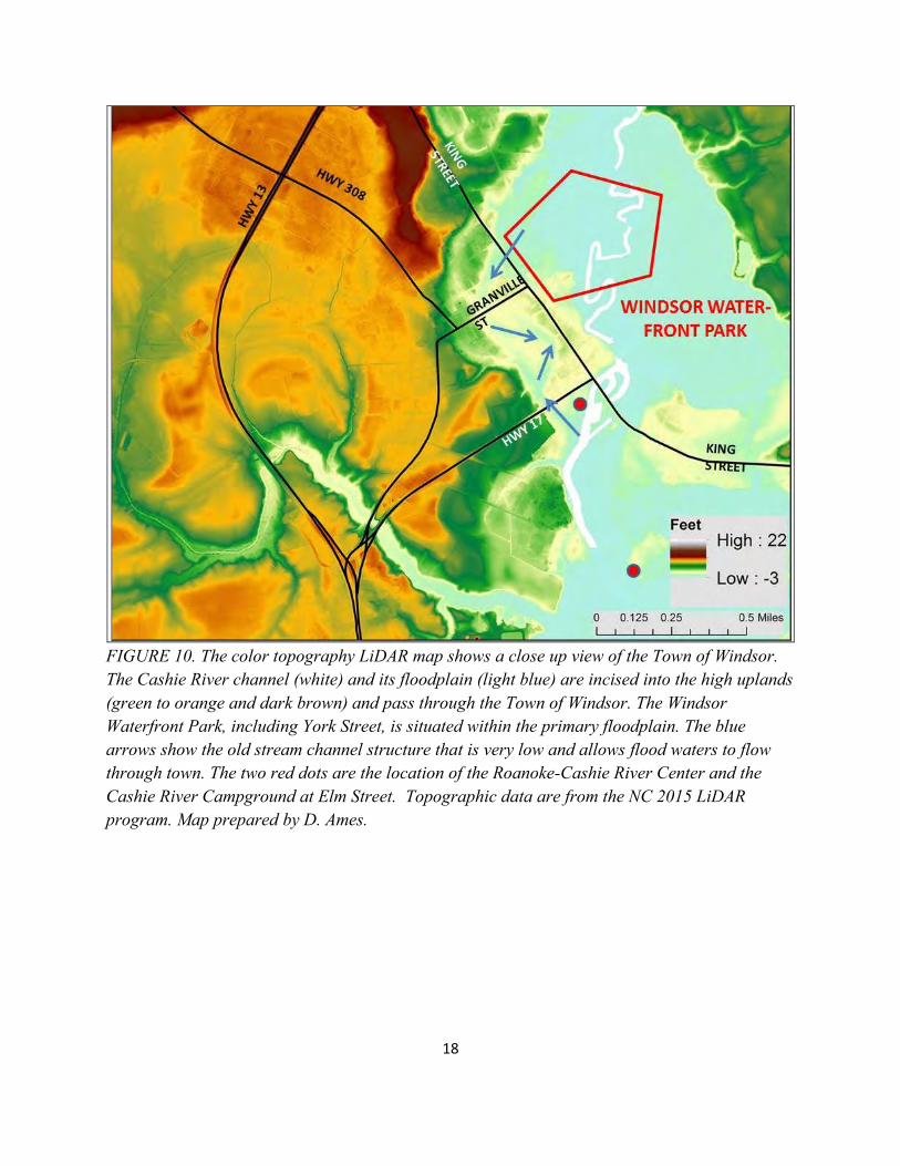
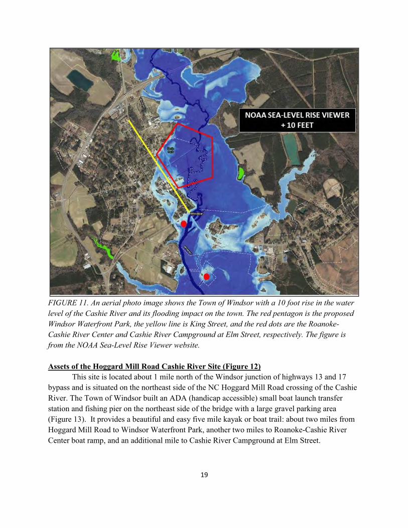
FIGURE 9. The color topography LiDAR map shows the Cashie River (white) and its floodplain (light blue) incised into the uplands (dark green to orange and dark brown) and passes through the Town of Windsor. The numbered sites outlined in red are the existing riverine assets for Windsor. 1) Hoggard Mill Road boat ramp and fishing pier; 2) downtown Windsor Waterfront Park; 3) Roanoke-Cashie River Center includes the Roanoke River National Wildlife Refuge Visitor’s Center, small boat launch, and extensive boardwalk and fishing pier; and 4) Cashie River Campground at Elm Street that includes a boat ramp, boardwalk, and the tree house village. Topographic data are from the NC 2015 LiDAR program. Map prepared by D. Ames. As can be seen in Figure 10, the portion of Windsor that frequently floods is the primary floodplain of the Cashie River, as well as an extremely low, old stream channel that runs directly through town. Since this area will continue to flood from both upstream and downstream storm events, the critical structures within this zone should be removed and replaced with assets that will enhance the region and can tolerate flooding. Figure 11 shows the flooding impact of a 10 foot rise in the Cashie River valley. Because of the diverse topography within the Town of Windsor, it has the unique opportunity to move all the endangered structures to high land within the town limits (Figures 9 and 11).
18
FIGURE 10. The color topography LiDAR map shows a close up view of the Town of Windsor. The Cashie River channel (white) and its floodplain (light blue) are incised into the high uplands (green to orange and dark brown) and pass through the Town of Windsor. The Windsor Waterfront Park, including York Street, is situated within the primary floodplain. The blue arrows show the old stream channel structure that is very low and allows flood waters to flow through town. The two red dots are the location of the Roanoke-Cashie River Center and the Cashie River Campground at Elm Street. Topographic data are from the NC 2015 LiDAR program. Map prepared by D. Ames.
19
FIGURE 11. An aerial photo image shows the Town of Windsor with a 10 foot rise in the water level of the Cashie River and its flooding impact on the town. The red pentagon is the proposed Windsor Waterfront Park, the yellow line is King Street, and the red dots are the Roanoke-Cashie River Center and Cashie River Campground at Elm Street, respectively. The figure is from the NOAA Sea-Level Rise Viewer website. Assets of the Hoggard Mill Road Cashie River Site (Figure 12) This site is located about 1 mile north of the Windsor junction of highways 13 and 17 bypass and is situated on the northeast side of the NC Hoggard Mill Road crossing of the Cashie River. The Town of Windsor built an ADA (handicap accessible) small boat launch transfer station and fishing pier on the northeast side of the bridge with a large gravel parking area (Figure 13). It provides a beautiful and easy five mile kayak or boat trail: about two miles from Hoggard Mill Road to Windsor Waterfront Park, another two miles to Roanoke-Cashie River Center boat ramp, and an additional mile to Cashie River Campground at Elm Street.
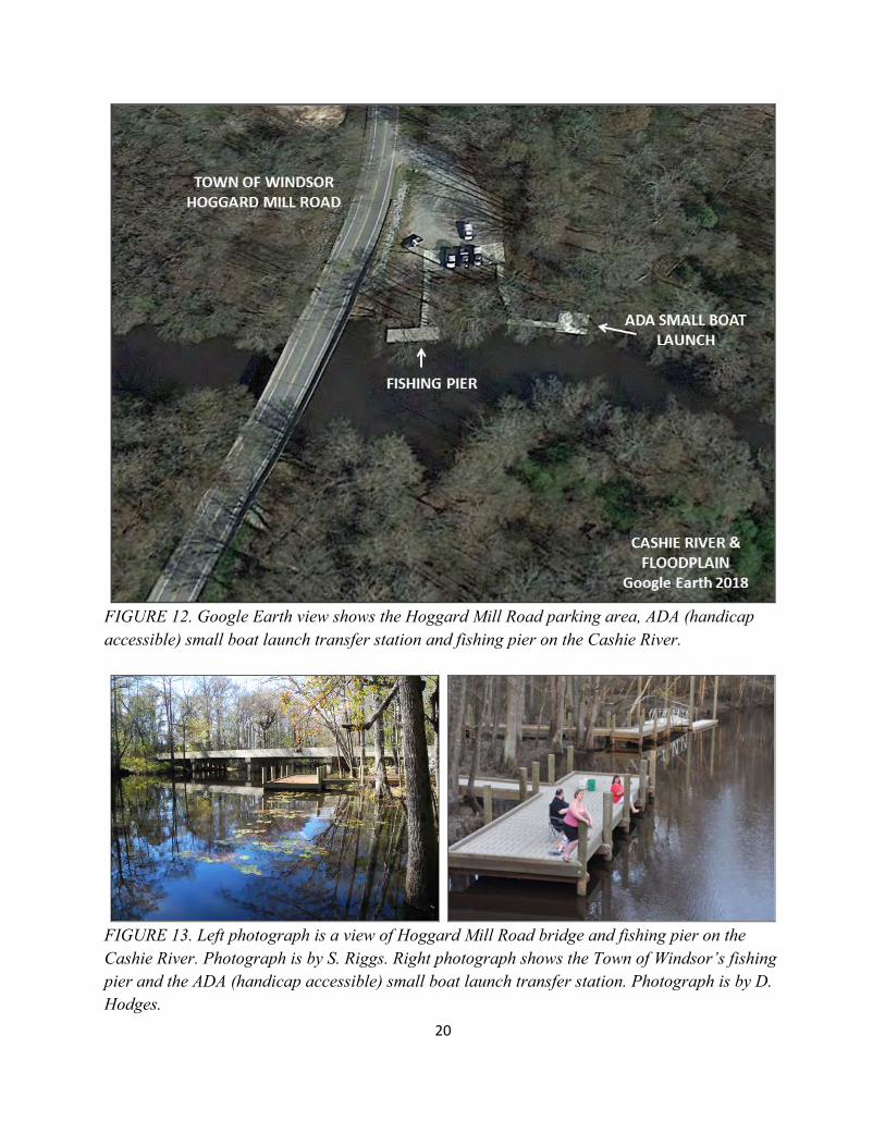
20
FIGURE 12. Google Earth view shows the Hoggard Mill Road parking area, ADA (handicap accessible) small boat launch transfer station and fishing pier on the Cashie River.
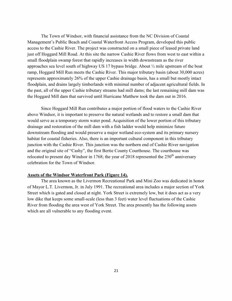
FIGURE 13. Left photograph is a view of Hoggard Mill Road bridge and fishing pier on the Cashie River. Photograph is by S. Riggs. Right photograph shows the Town of Windsor’s fishing pier and the ADA (handicap accessible) small boat launch transfer station. Photograph is by D. Hodges.
21
The Town of Windsor, with financial assistance from the NC Division of Coastal Management’s Public Beach and Coastal Waterfront Access Program, developed this public access to the Cashie River. The project was constructed on a small piece of leased private land just off Hoggard Mill Road. At this site the narrow Cashie River flows from west to east within a small floodplain swamp forest that rapidly increases in width downstream as the river approaches sea level south of highway US 17 bypass bridge. About ½ mile upstream of the boat ramp, Hoggard Mill Run meets the Cashie River. This major tributary basin (about 30,000 acres) represents approximately 26% of the upper Cashie drainage basin, has a small but mostly intact floodplain, and drains largely timberlands with minimal number of adjacent agricultural fields. In the past, all of the upper Cashie tributary streams had mill dams; the last remaining mill dam was the Hoggard Mill dam that survived until Hurricane Matthew took the dam out in 2016. Since Hoggard Mill Run contributes a major portion of flood waters to the Cashie River above Windsor, it is important to preserve the natural wetlands and to restore a small dam that would serve as a temporary storm water pond. Acquisition of the lower portion of this tributary drainage and restoration of the mill dam with a fish ladder would help minimize future downstream flooding and would preserve a major wetland eco-system and its primary nursery habitat for coastal fisheries. Also, there is an important cultural component in this tributary junction with the Cashie River. This junction was the northern end of Cashie River navigation and the original site of “Cashy”, the first Bertie County Courthouse. The courthouse was relocated to present day Windsor in 1768; the year of 2018 represented the 250th anniversary celebration for the Town of Windsor. Assets of the Windsor Waterfront Park (Figure 14). The area known as the Livermon Recreational Park and Mini Zoo was dedicated in honor of Mayor L.T. Livermon, Jr. in July 1991. The recreational area includes a major section of York Street which is gated and closed at night. York Street is extremely low, but it does act as a very low dike that keeps some small-scale (less than 3 feet) water level fluctuations of the Cashie River from flooding the area west of York Street. The area presently has the following assets which are all vulnerable to any flooding event.
22
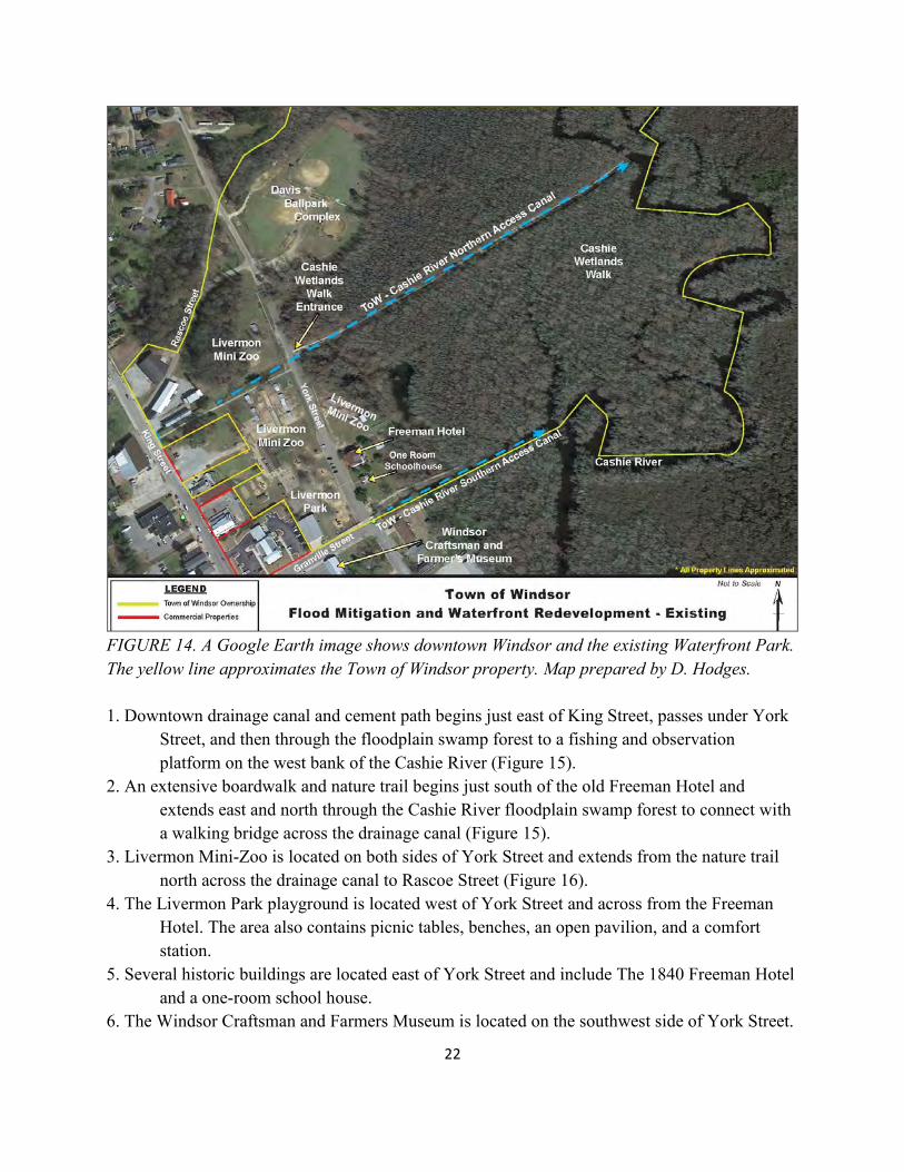
FIGURE 14. A Google Earth image shows downtown Windsor and the existing Waterfront Park. The yellow line approximates the Town of Windsor property. Map prepared by D. Hodges. 1. Downtown drainage canal and cement path begins just east of King Street, passes under York Street, and then through the floodplain swamp forest to a fishing and observation platform on the west bank of the Cashie River (Figure 15). 2. An extensive boardwalk and nature trail begins just south of the old Freeman Hotel and extends east and north through the Cashie River floodplain swamp forest to connect with a walking bridge across the drainage canal (Figure 15). 3. Livermon Mini-Zoo is located on both sides of York Street and extends from the nature trail north across the drainage canal to Rascoe Street (Figure 16). 4. The Livermon Park playground is located west of York Street and across from the Freeman Hotel. The area also contains picnic tables, benches, an open pavilion, and a comfort station. 5. Several historic buildings are located east of York Street and include The 1840 Freeman Hotel and a one-room school house. 6. The Windsor Craftsman and Farmers Museum is located on the southwest side of York Street.
23
7. The Davis ballpark complex is located on the far northeast side of York Street. 8. The Town of Windsor has just obtained the land and buildings of the former Timberland Company that straddles Rascoe Road and extends from King Street to the buffalo facility in the Livermon Mini-Zoo.
FIGURE 15. Left panel is looking east along the drainage canal and walkway dug in the 1930s from downtown to the Cashie River in the distance. Right panel is a boardwalk and nature trail built in the Cashie River floodplain. Photographs are by S. Riggs.
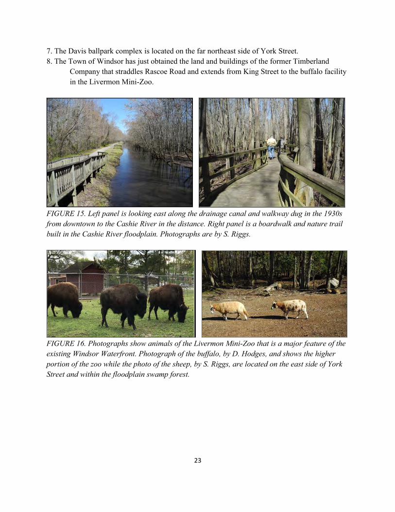
FIGURE 16. Photographs show animals of the Livermon Mini-Zoo that is a major feature of the existing Windsor Waterfront. Photograph of the buffalo, by D. Hodges, and shows the higher portion of the zoo while the photo of the sheep, by S. Riggs, are located on the east side of York Street and within the floodplain swamp forest.
24
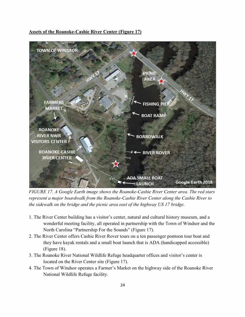
Assets of the Roanoke-Cashie River Center (Figure 17)
FIGURE 17. A Google Earth image shows the Roanoke-Cashie River Center area. The red stars represent a major boardwalk from the Roanoke-Cashie River Center along the Cashie River to the sidewalk on the bridge and the picnic area east of the highway US 17 bridge. 1. The River Center building has a visitor’s center, natural and cultural history museum, and a wonderful meeting facility, all operated in partnership with the Town of Windsor and the North Carolina “Partnership For the Sounds” (Figure 17). 2. The River Center offers Cashie River Rover tours on a ten passenger pontoon tour boat and they have kayak rentals and a small boat launch that is ADA (handicapped accessible) (Figure 18). 3. The Roanoke River National Wildlife Refuge headquarter offices and visitor’s center is located on the River Center site (Figure 17). 4. The Town of Windsor operates a Farmer’s Market on the highway side of the Roanoke River National Wildlife Refuge facility.
25
5. An extensive river-bank boardwalk (with amphitheater, trailered boat ramp, and fishing pier) extends to King Street/Hwy US 17 Business bridge with sidewalks across the Cashie River bridge to the southeast parking lot and picnic area (Figures 17, 18, & 19). 6. The black-water of the Cashie River also has access to the downstream to the following assets. a. Cashie River Campground at Elm Street, including the NC WRC boat ramp and tree house village, b. The Roanoke River Partners “Lost Boat” camping platform (about 9 miles southeast of Windsor), and c. The Sans Souci ferry and NC WRC boat ramp (about 13 miles southeast of Windsor).
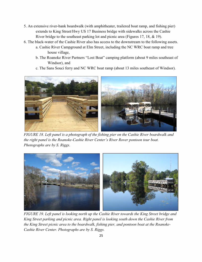
FIGURE 18. Left panel is a photograph of the fishing pier on the Cashie River boardwalk and the right panel is the Roanoke-Cashie River Center’s River Rover pontoon tour boat. Photographs are by S. Riggs.
FIGURE 19. Left panel is looking north up the Cashie River towards the King Street bridge and King Street parking and picnic area. Right panel is looking south down the Cashie River from the King Street picnic area to the boardwalk, fishing pier, and pontoon boat at the Roanoke-Cashie River Center. Photographs are by S. Riggs.
26
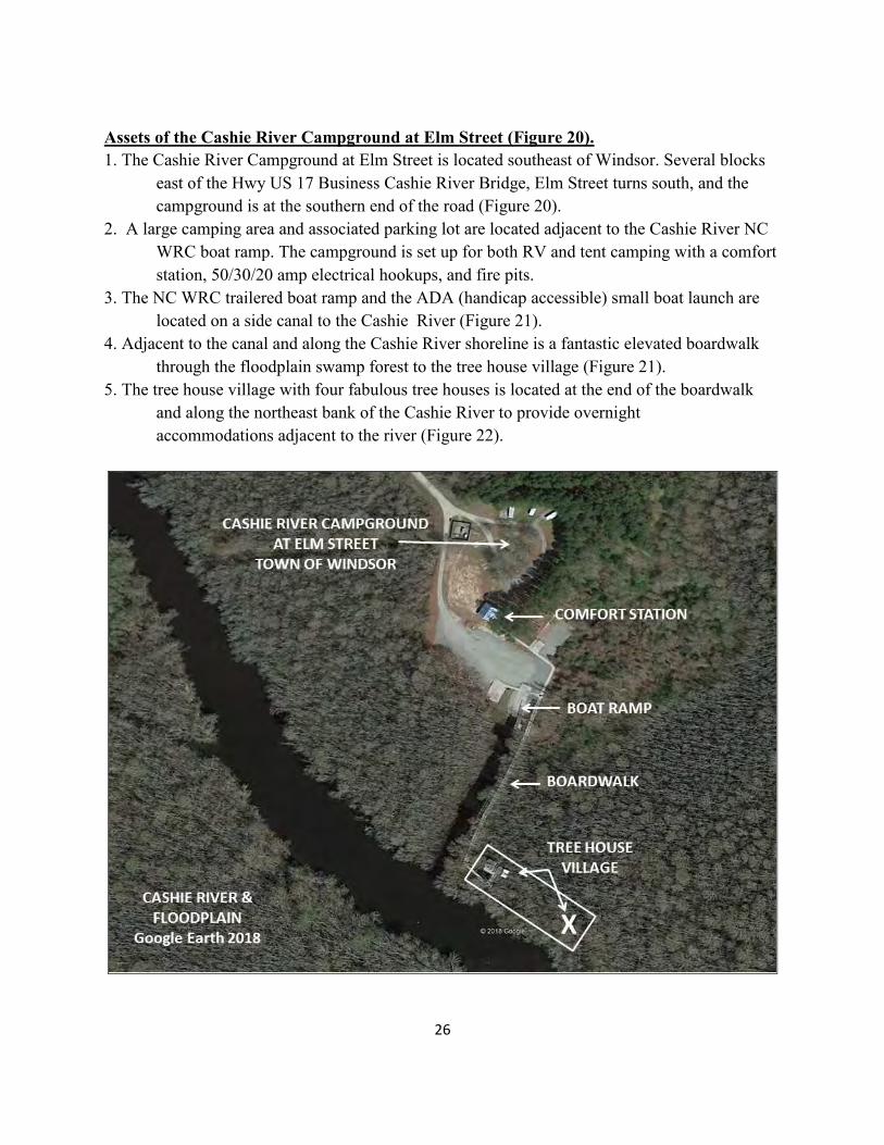
Assets of the Cashie River Campground at Elm Street (Figure 20). 1. The Cashie River Campground at Elm Street is located southeast of Windsor. Several blocks east of the Hwy US 17 Business Cashie River Bridge, Elm Street turns south, and the campground is at the southern end of the road (Figure 20). 2. A large camping area and associated parking lot are located adjacent to the Cashie River NC WRC boat ramp. The campground is set up for both RV and tent camping with a comfort station, 50/30/20 amp electrical hookups, and fire pits. 3. The NC WRC trailered boat ramp and the ADA (handicap accessible) small boat launch are located on a side canal to the Cashie River (Figure 21). 4. Adjacent to the canal and along the Cashie River shoreline is a fantastic elevated boardwalk through the floodplain swamp forest to the tree house village (Figure 21). 5. The tree house village with four fabulous tree houses is located at the end of the boardwalk and along the northeast bank of the Cashie River to provide overnight accommodations adjacent to the river (Figure 22).
27
FIGURE 20. A Google Earth image shows the Cashie River Campground at Elm Street, the trailered boat ramp and ADA (handicap accessible) small boat launch, boardwalk, and the tree house village (white box). The X shows the approximate location of the two new tree houses recently constructed approximately 225 feet downstream.
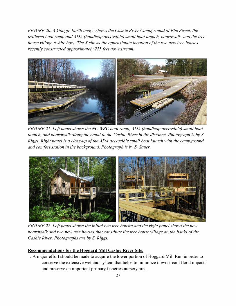
FIGURE 21. Left panel shows the NC WRC boat ramp, ADA (handicap accessible) small boat launch, and boardwalk along the canal to the Cashie River in the distance. Photograph is by S. Riggs. Right panel is a close-up of the ADA accessible small boat launch with the campground and comfort station in the background. Photograph is by S. Sauer.
FIGURE 22. Left panel shows the initial two tree houses and the right panel shows the new boardwalk and two new tree houses that constitute the tree house village on the banks of the Cashie River. Photographs are by S. Riggs. Recommendations for the Hoggard Mill Cashie River Site. 1. A major effort should be made to acquire the lower portion of Hoggard Mill Run in order to conserve the extensive wetland system that helps to minimize downstream flood impacts and preserve an important primary fisheries nursery area.
28
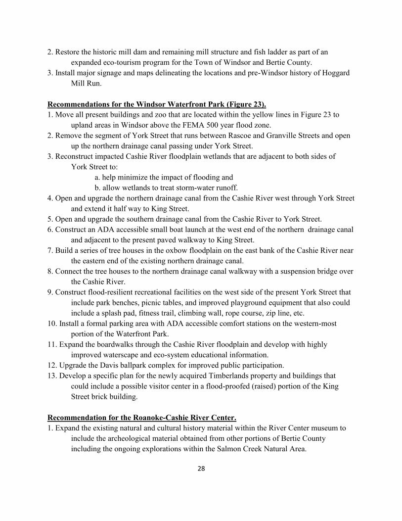
2. Restore the historic mill dam and remaining mill structure and fish ladder as part of an expanded eco-tourism program for the Town of Windsor and Bertie County. 3. Install major signage and maps delineating the locations and pre-Windsor history of Hoggard Mill Run. Recommendations for the Windsor Waterfront Park (Figure 23). 1. Move all present buildings and zoo that are located within the yellow lines in Figure 23 to upland areas in Windsor above the FEMA 500 year flood zone. 2. Remove the segment of York Street that runs between Rascoe and Granville Streets and open up the northern drainage canal passing under York Street. 3. Reconstruct impacted Cashie River floodplain wetlands that are adjacent to both sides of York Street to: a. help minimize the impact of flooding and b. allow wetlands to treat storm-water runoff. 4. Open and upgrade the northern drainage canal from the Cashie River west through York Street and extend it half way to King Street. 5. Open and upgrade the southern drainage canal from the Cashie River to York Street. 6. Construct an ADA accessible small boat launch at the west end of the northern drainage canal and adjacent to the present paved walkway to King Street. 7. Build a series of tree houses in the oxbow floodplain on the east bank of the Cashie River near the eastern end of the existing northern drainage canal. 8. Connect the tree houses to the northern drainage canal walkway with a suspension bridge over the Cashie River. 9. Construct flood-resilient recreational facilities on the west side of the present York Street that include park benches, picnic tables, and improved playground equipment that also could include a splash pad, fitness trail, climbing wall, rope course, zip line, etc. 10. Install a formal parking area with ADA accessible comfort stations on the western-most portion of the Waterfront Park. 11. Expand the boardwalks through the Cashie River floodplain and develop with highly improved waterscape and eco-system educational information. 12. Upgrade the Davis ballpark complex for improved public participation. 13. Develop a specific plan for the newly acquired Timberlands property and buildings that could include a possible visitor center in a flood-proofed (raised) portion of the King Street brick building. Recommendation for the Roanoke-Cashie River Center. 1. Expand the existing natural and cultural history material within the River Center museum to include the archeological material obtained from other portions of Bertie County including the ongoing explorations within the Salmon Creek Natural Area.
29
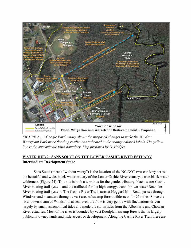
FIGURE 23. A Google Earth image shows the proposed changes to make the Windsor Waterfront Park more flooding resilient as indicated in the orange colored labels. The yellow line is the approximate town boundary. Map prepared by D. Hodges. WATER HUB 2. SANS SOUCI ON THE LOWER CASHIE RIVER ESTUARY Intermediate Development Stage Sans Souci (means “without worry”) is the location of the NC DOT two-car ferry across the beautiful and wide, black-water estuary of the Lower Cashie River estuary, a true black-water wilderness (Figure 24). This site is both a terminus for the gentle, tributary, black-water Cashie River boating trail system and the trailhead for the high energy, trunk, brown-water Roanoke River boating trail system. The Cashie River Trail starts at Hoggard Mill Road, passes through Windsor, and meanders through a vast area of swamp forest wilderness for 25 miles. Since the river downstream of Windsor is at sea level, the flow is very gentle with fluctuations driven largely by small astronomical tides and moderate storm tides from the Albemarle and Chowan River estuaries. Most of the river is bounded by vast floodplain swamp forests that is largely publically owned lands and little access or development. Along the Cashie River Trail there are
30
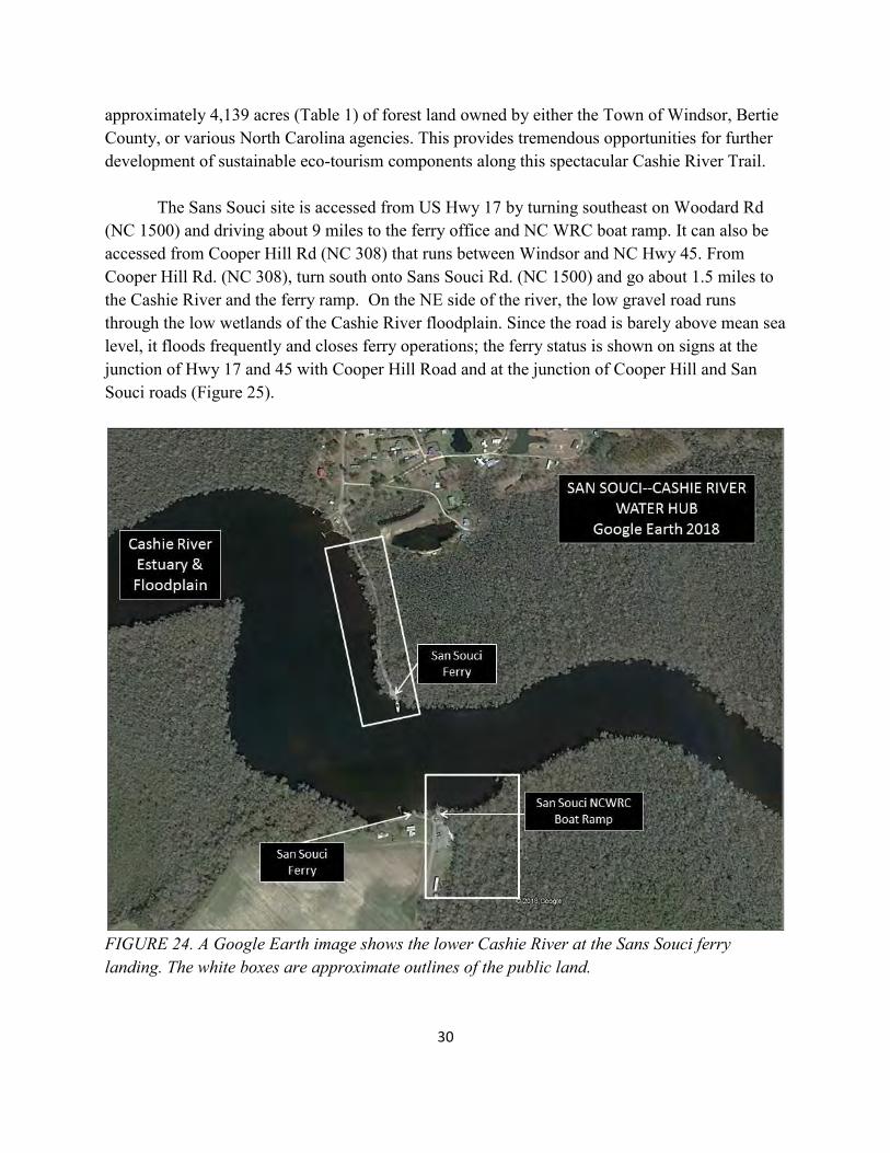
approximately 4,139 acres (Table 1) of forest land owned by either the Town of Windsor, Bertie County, or various North Carolina agencies. This provides tremendous opportunities for further development of sustainable eco-tourism components along this spectacular Cashie River Trail. The Sans Souci site is accessed from US Hwy 17 by turning southeast on Woodard Rd (NC 1500) and driving about 9 miles to the ferry office and NC WRC boat ramp. It can also be accessed from Cooper Hill Rd (NC 308) that runs between Windsor and NC Hwy 45. From Cooper Hill Rd. (NC 308), turn south onto Sans Souci Rd. (NC 1500) and go about 1.5 miles to the Cashie River and the ferry ramp. On the NE side of the river, the low gravel road runs through the low wetlands of the Cashie River floodplain. Since the road is barely above mean sea level, it floods frequently and closes ferry operations; the ferry status is shown on signs at the junction of Hwy 17 and 45 with Cooper Hill Road and at the junction of Cooper Hill and San Souci roads (Figure 25).
FIGURE 24. A Google Earth image shows the lower Cashie River at the Sans Souci ferry landing. The white boxes are approximate outlines of the public land.
31
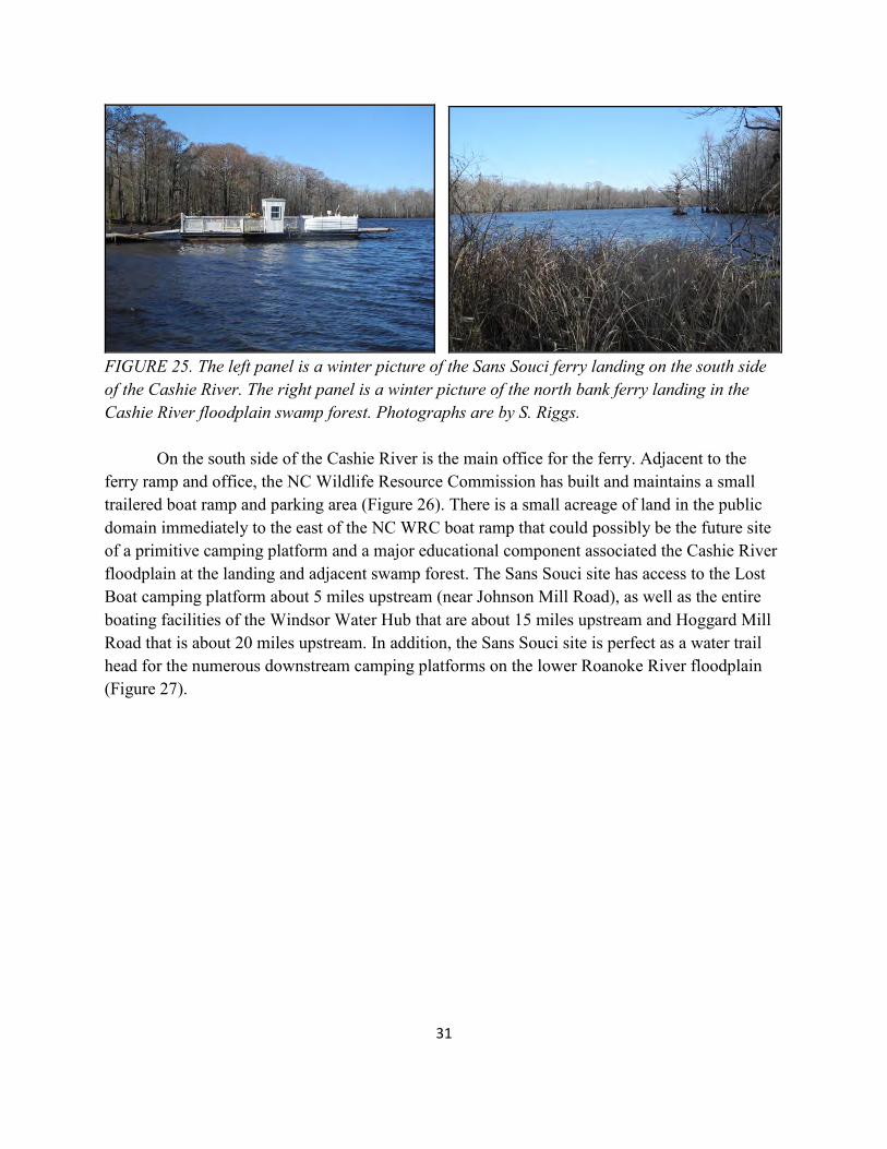
FIGURE 25. The left panel is a winter picture of the Sans Souci ferry landing on the south side of the Cashie River. The right panel is a winter picture of the north bank ferry landing in the Cashie River floodplain swamp forest. Photographs are by S. Riggs. On the south side of the Cashie River is the main office for the ferry. Adjacent to the ferry ramp and office, the NC Wildlife Resource Commission has built and maintains a small trailered boat ramp and parking area (Figure 26). There is a small acreage of land in the public domain immediately to the east of the NC WRC boat ramp that could possibly be the future site of a primitive camping platform and a major educational component associated the Cashie River floodplain at the landing and adjacent swamp forest. The Sans Souci site has access to the Lost Boat camping platform about 5 miles upstream (near Johnson Mill Road), as well as the entire boating facilities of the Windsor Water Hub that are about 15 miles upstream and Hoggard Mill Road that is about 20 miles upstream. In addition, the Sans Souci site is perfect as a water trail head for the numerous downstream camping platforms on the lower Roanoke River floodplain (Figure 27).
32
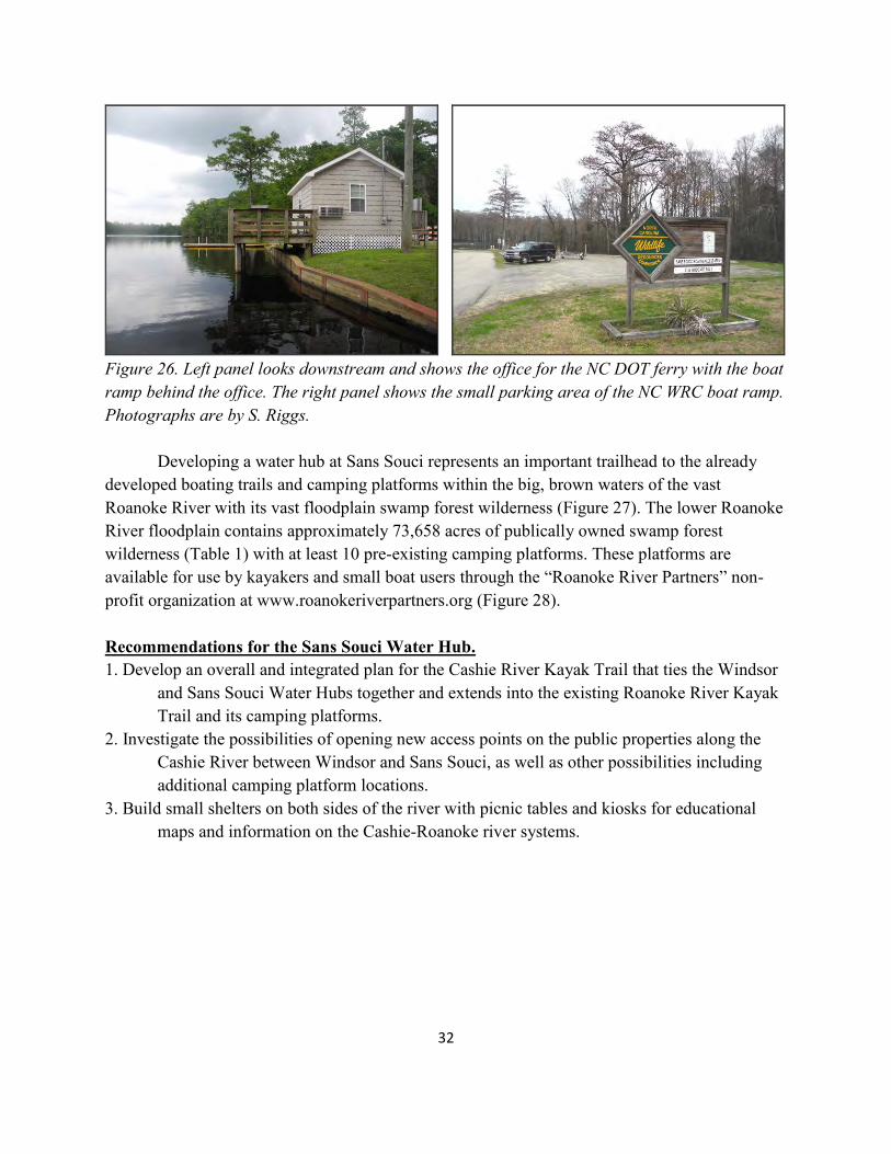
Figure 26. Left panel looks downstream and shows the office for the NC DOT ferry with the boat ramp behind the office. The right panel shows the small parking area of the NC WRC boat ramp. Photographs are by S. Riggs. Developing a water hub at Sans Souci represents an important trailhead to the already developed boating trails and camping platforms within the big, brown waters of the vast Roanoke River with its vast floodplain swamp forest wilderness (Figure 27). The lower Roanoke River floodplain contains approximately 73,658 acres of publically owned swamp forest wilderness (Table 1) with at least 10 pre-existing camping platforms. These platforms are available for use by kayakers and small boat users through the “Roanoke River Partners” non-profit organization at www.roanokeriverpartners.org (Figure 28). Recommendations for the Sans Souci Water Hub. 1. Develop an overall and integrated plan for the Cashie River Kayak Trail that ties the Windsor and Sans Souci Water Hubs together and extends into the existing Roanoke River Kayak Trail and its camping platforms. 2. Investigate the possibilities of opening new access points on the public properties along the Cashie River between Windsor and Sans Souci, as well as other possibilities including additional camping platform locations. 3. Build small shelters on both sides of the river with picnic tables and kiosks for educational maps and information on the Cashie-Roanoke river systems.
33
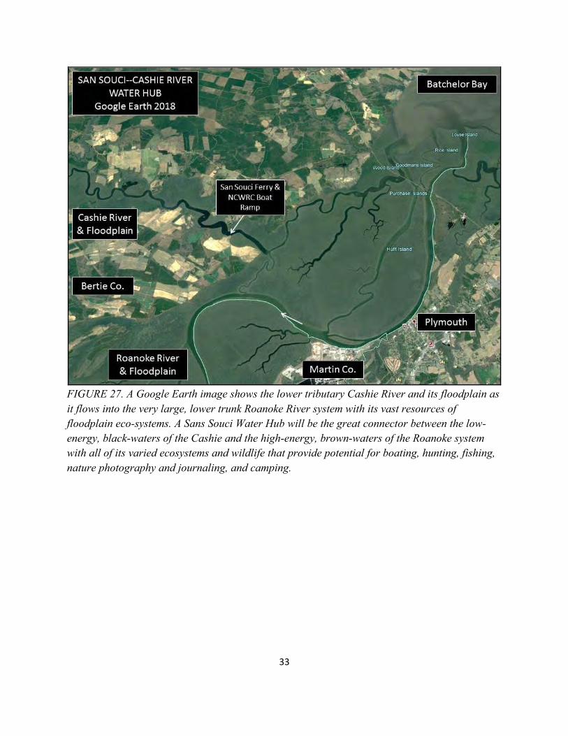
FIGURE 27. A Google Earth image shows the lower tributary Cashie River and its floodplain as it flows into the very large, lower trunk Roanoke River system with its vast resources of floodplain eco-systems. A Sans Souci Water Hub will be the great connector between the low-energy, black-waters of the Cashie and the high-energy, brown-waters of the Roanoke system with all of its varied ecosystems and wildlife that provide potential for boating, hunting, fishing, nature photography and journaling, and camping.
34
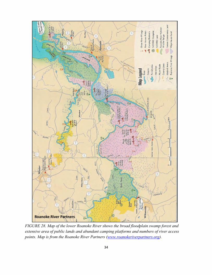
FIGURE 28. Map of the lower Roanoke River shows the broad floodplain swamp forest and extensive area of public lands and abundant camping platforms and numbers of river access points. Map is from the Roanoke River Partners (www.roanokeriverpartners.org).
Roanoke River Partners
35
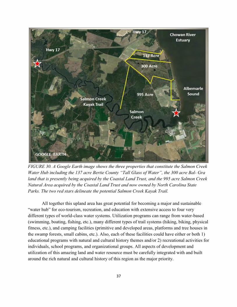
WATER HUB 3. SALMON CREEK RIVERS TO SOUNDS Early Development Stage The Salmon Creek Water Hub occurs at the confluence of five different kinds of world-class water systems that include the following.
The high energy estuarine waters of the east-west oriented, brown-water Albemarle Sound;
The fresh waters of the north-south oriented, black-water Chowan River Estuary; The high energy, brown-waters of the Roanoke River; The meandering, black-waters of the Salmon Creek tributary; and A series of small ephemeral streams incised into the flat-lying landscape of the Talbot
Terrace. These complex and interacting water systems combine to provide an integrated recreational area, a unique region of natural and cultural resources, and exciting environmental educational opportunities. In 2015 the Bertie County Board of Commissioners acquired 137 acres of land on Albemarle Sound to secure public water access for recreation and tourism. This land acquisition was made possible with a $500,000 grant from the NC Parks and Recreation Trust Fund and $500,000 of Bertie County funds. In 2017-18 the NC Coastal Land Trust acquired a 995 acre property almost adjacent to the Bertie County 137 acres. In the early 2000s this 995 acre property was destined to become a 2,800 unit coastal development with a 212 slip marina. With time and the economic downturn, the property ultimately came up for sale. To complement the county’s coastal investment, the NC Coastal Land Trust purchased the land and on November 9, 2018 turned it over to NC State Parks as the Salmon Creek Natural Heritage Area. A 300 acre piece of land lies between the County and State properties and is presently being considered for acquisition to complete an integrated 1,432 acre “Rivers to Sounds” educational and recreational water hub. These acquisitions provide major public access to the confluence of a rich system of five vastly different kinds of water resources. Bertie County can now build an integrated and sustainable program based on the previous efforts by numerous federal and state agencies, private conservation organizations, small tour businesses in the lower Roanoke River floodplain, and the Town of Windsor on the Cashie River. The Salmon Creek Water Hub is located south of US Hwy 17 at the southern end of the black-waters of the north-south oriented Chowan River estuary and where it flows into the western end of the estuarine waters of the east-west oriented Albemarle Sound (Figure 29). The Water Hub is accessed by Bal-Gra road (NC 1501) that turns southeast off of US hwy 17 just west of the Chowan River estuary bridge (Figure 30) and consists of 3 major pieces of property that have water frontage on 1.3 miles of Albemarle Sound and along 3.5 miles of Salmon Creek.
36
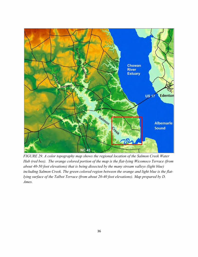
FIGURE 29. A color topography map shows the regional location of the Salmon Creek Water Hub (red box). The orange colored portion of the map is the flat-lying Wicomoco Terrace (from about 40-50 foot elevations) that is being dissected by the many stream valleys (light blue) including Salmon Creek. The green colored region between the orange and light blue is the flat-lying surface of the Talbot Terrace (from about 20-40 foot elevations). Map prepared by D. Ames.
37
FIGURE 30. A Google Earth image shows the three properties that constitute the Salmon Creek Water Hub including the 137 acre Bertie County “Tall Glass of Water”, the 300 acre Bal- Gra land that is presently being acquired by the Coastal Land Trust, and the 995 acre Salmon Creek Natural Area acquired by the Coastal Land Trust and now owned by North Carolina State Parks. The two red stars delineate the potential Salmon Creek Kayak Trail. All together this upland area has great potential for becoming a major and sustainable “water hub” for eco-tourism, recreation, and education with extensive access to four very different types of world-class water systems. Utilization programs can range from water-based (swimming, boating, fishing, etc.), many different types of trail systems (hiking, biking, physical fitness, etc.), and camping facilities (primitive and developed areas, platforms and tree houses in the swamp forests, small cabins, etc.). Also, each of these facilities could have either or both 1) educational programs with natural and cultural history themes and/or 2) recreational activities for individuals, school programs, and organizational groups. All aspects of development and utilization of this amazing land and water resource must be carefully integrated with and built around the rich natural and cultural history of this region as the major priority.
38
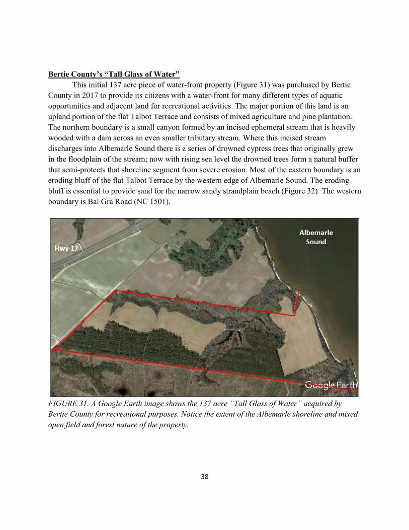
Bertie County’s “Tall Glass of Water” This initial 137 acre piece of water-front property (Figure 31) was purchased by Bertie County in 2017 to provide its citizens with a water-front for many different types of aquatic opportunities and adjacent land for recreational activities. The major portion of this land is an upland portion of the flat Talbot Terrace and consists of mixed agriculture and pine plantation. The northern boundary is a small canyon formed by an incised ephemeral stream that is heavily wooded with a dam across an even smaller tributary stream. Where this incised stream discharges into Albemarle Sound there is a series of drowned cypress trees that originally grew in the floodplain of the stream; now with rising sea level the drowned trees form a natural buffer that semi-protects that shoreline segment from severe erosion. Most of the eastern boundary is an eroding bluff of the flat Talbot Terrace by the western edge of Albemarle Sound. The eroding bluff is essential to provide sand for the narrow sandy strandplain beach (Figure 32). The western boundary is Bal Gra Road (NC 1501).
FIGURE 31. A Google Earth image shows the 137 acre “Tall Glass of Water” acquired by Bertie County for recreational purposes. Notice the extent of the Albemarle shoreline and mixed open field and forest nature of the property.
39
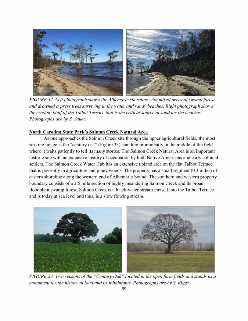
FIGURE 32. Left photograph shows the Albemarle shoreline with mixed areas of swamp forest and drowned cypress trees surviving in the water and sandy beaches. Right photograph shows the eroding bluff of the Talbot Terrace that is the critical source of sand for the beaches. Photographs are by S. Sauer. North Carolina State Park’s Salmon Creek Natural Area As one approaches the Salmon Creek site through the upper agricultural fields, the most striking image is the “century oak” (Figure 33) standing prominently in the middle of the field where it waits patiently to tell its many stories. The Salmon Creek Natural Area is an important historic site with an extensive history of occupation by both Native Americans and early colonial settlers. The Salmon Creek Water Hub has an extensive upland area on the flat Talbot Terrace that is presently in agriculture and piney woods. The property has a small segment (0.3 miles) of eastern shoreline along the western end of Albemarle Sound. The southern and western property boundary consists of a 3.5 mile section of highly meandering Salmon Creek and its broad floodplain swamp forest. Salmon Creek is a black-water stream incised into the Talbot Terrace and is today at sea level and thus, is a slow flowing stream.
FIGURE 33. Two seasons of the “Century Oak” located in the open farm fields and stands as a monument for the history of land and its inhabitants. Photographs are by S. Riggs.
40
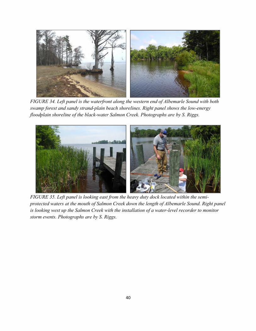
FIGURE 34. Left panel is the waterfront along the western end of Albemarle Sound with both swamp forest and sandy strand-plain beach shorelines. Right panel shows the low-energy floodplain shoreline of the black-water Salmon Creek. Photographs are by S. Riggs.
FIGURE 35. Left panel is looking east from the heavy duty dock located within the semi-protected waters at the mouth of Salmon Creek down the length of Albemarle Sound. Right panel is looking west up the Salmon Creek with the installation of a water-level recorder to monitor storm events. Photographs are by S. Riggs.
41
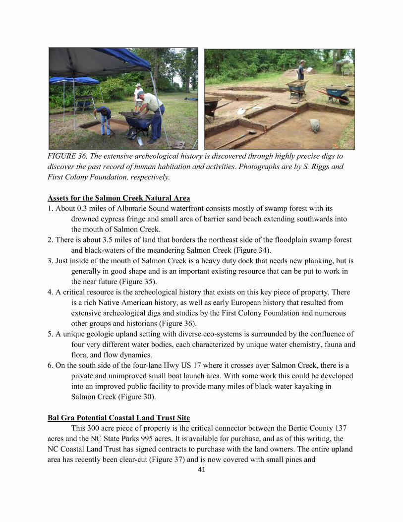
FIGURE 36. The extensive archeological history is discovered through highly precise digs to discover the past record of human habitation and activities. Photographs are by S. Riggs and First Colony Foundation, respectively. Assets for the Salmon Creek Natural Area 1. About 0.3 miles of Albmarle Sound waterfront consists mostly of swamp forest with its drowned cypress fringe and small area of barrier sand beach extending southwards into the mouth of Salmon Creek. 2. There is about 3.5 miles of land that borders the northeast side of the floodplain swamp forest and black-waters of the meandering Salmon Creek (Figure 34). 3. Just inside of the mouth of Salmon Creek is a heavy duty dock that needs new planking, but is generally in good shape and is an important existing resource that can be put to work in the near future (Figure 35). 4. A critical resource is the archeological history that exists on this key piece of property. There is a rich Native American history, as well as early European history that resulted from extensive archeological digs and studies by the First Colony Foundation and numerous other groups and historians (Figure 36). 5. A unique geologic upland setting with diverse eco-systems is surrounded by the confluence of four very different water bodies, each characterized by unique water chemistry, fauna and flora, and flow dynamics. 6. On the south side of the four-lane Hwy US 17 where it crosses over Salmon Creek, there is a private and unimproved small boat launch area. With some work this could be developed into an improved public facility to provide many miles of black-water kayaking in Salmon Creek (Figure 30). Bal Gra Potential Coastal Land Trust Site This 300 acre piece of property is the critical connector between the Bertie County 137 acres and the NC State Parks 995 acres. It is available for purchase, and as of this writing, the NC Coastal Land Trust has signed contracts to purchase with the land owners. The entire upland area has recently been clear-cut (Figure 37) and is now covered with small pines and
42
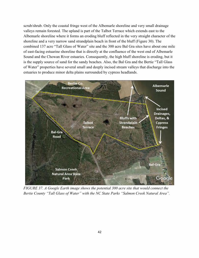
scrub/shrub. Only the coastal fringe west of the Albemarle shoreline and very small drainage valleys remain forested. The upland is part of the Talbot Terrace which extends east to the Albemarle shoreline where it forms an eroding bluff reflected in the very straight character of the shoreline and a very narrow sand strandplain beach in front of the bluff (Figure 30). The combined 137 acre “Tall Glass of Water” site and the 300 acre Bal Gra sites have about one mile of east-facing estuarine shoreline that is directly at the confluence of the west end of Albemarle Sound and the Chowan River estuaries. Consequently, the high bluff shoreline is eroding, but it is the supply source of sand for the sandy beaches. Also, the Bal Gra and the Bertie “Tall Glass of Water” properties have several small and deeply incised stream valleys that discharge into the estuaries to produce minor delta plains surrounded by cypress headlands.
FIGURE 37. A Google Earth image shows the potential 300 acre site that would connect the Bertie County “Tall Glass of Water” with the NC State Parks “Salmon Creek Natural Area”.
43
Recommendations for the Salmon Creek Rivers to Sounds Water Hub. 1. Develop an overall and integrated plan for the Salmon Creek Water Hub that ties the 1,432 acres together as one unique natural and cultural resource-based “Rivers to Sounds” educational and recreational facility with each of the three properties cooperating to produce one world-class facility. 2. The Bertie County property could feature the following aspects of the program.
a. Instructional swimming, boating, and water safety programs on the Albemarle Sound waterfront for the Bertie school system and the public (Figure 32). b. Water tour programs into different components of the open waters (Roanoke, Albemarle, and Chowan coastal system) of the “Bertie Water Crescent” (Figures 30 and 31). c. Camping areas that range from RVs, rustic cabins, tree houses, primitive camps, etc. d. Natural areas to provide trails for hiking, biking, GPS geo-caching, physical fitness, rope courses, climbing walls, zip lines, etc. e. General picnic areas with tables, benches, fire pits, and shelters, etc. f. Small pavilions for family gatherings, weddings, meetings, etc.
3. The NC Salmon Creek Natural Area could feature the following aspects of the program.
a. Develop a year round, “Rivers to Sounds” educational program and associated facilities that feature the regions natural sciences, environmental resources, and cultural history for all Bertie County school students and adult learning center (Figure 38). A. The program could be a partnership between Bertie County School System, North Carolina State Parks, and a 501 (c) 3 nonprofit science education program such as A Time For Science. B. Professional natural science and environmental education staff could be employed by the 501 (c) 3 nonprofit organization to partner with the county schools and state parks personnel. C. The program could replicate a curriculum similar to the “Sound to Sea” summer program held at Pine Knoll Shores. D. The trails, education programs, archeological digs, informational kiosks, etc. should be focused directly on the natural and cultural resources and earth and human history of coastal North Carolina.
E. Education programs should focus on the regionally relevant programs (e.g., archeology and anthropology, environmental issues, water dynamics, ecology and ecological services, and geologic and cultural history, etc.). F. The artifacts coming from research activities on the properties should all be archived and displayed in a small museum in Windsor (e.g., Roanoke- Cashie River Center museum).
44
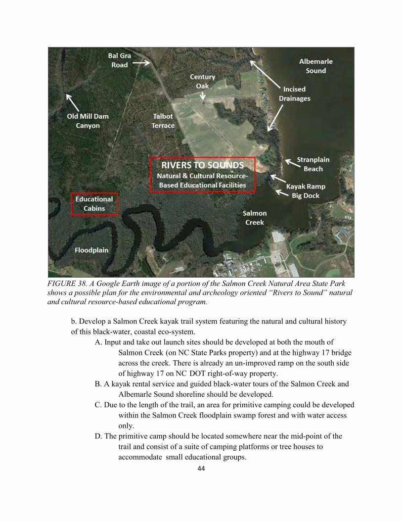
FIGURE 38. A Google Earth image of a portion of the Salmon Creek Natural Area State Park shows a possible plan for the environmental and archeology oriented “Rivers to Sound” natural and cultural resource-based educational program.
b. Develop a Salmon Creek kayak trail system featuring the natural and cultural history of this black-water, coastal eco-system. A. Input and take out launch sites should be developed at both the mouth of Salmon Creek (on NC State Parks property) and at the highway 17 bridge across the creek. There is already an un-improved ramp on the south side of highway 17 on NC DOT right-of-way property. B. A kayak rental service and guided black-water tours of the Salmon Creek and Albemarle Sound shoreline should be developed. C. Due to the length of the trail, an area for primitive camping could be developed within the Salmon Creek floodplain swamp forest and with water access only. D. The primitive camp should be located somewhere near the mid-point of the trail and consist of a suite of camping platforms or tree houses to accommodate small educational groups.
45
c. The heavy duty dock could be utilized for organized regional boat tours featuring the natural and cultural resources of the Albemarle-Roanoke-Chowan coastal water systems.
A. The educational tour program could be similar to the recent tour sponsored by the NC Division of Natural and Cultural Resources on the “Belle of Washington” in spring of 2018. B. This 3-day tour had 50 paid participants and featured Bland Simpson, Tom Earnhardt, and David Cecelski as the professional lecturers. C. The tour started at Elizabeth City and stopped at specific locations (Hertford, Edenton, Columbia, and Plymouth) the group was met with buses to visit various historic sites, parks, and museums, etc. D. The Rivers to Sounds environmental educational program, archeological sites and history, and recreational components of the Salmon Creek Water Hub could all be featured, along with an oyster roast or seafood boil and side- trips to Windsor and Hope Plantation, etc. (Figures 39 and 40).
4. Potential development plans for the Bal Gra property should be complementary to and integrated with both the Bertie County’s “Tall Glass of Water” and the NC State Park’s Salmon Creek Natural Area. This recently clear-cut piece of land could include major areas for parking and public facilities, as well as trail systems for horse-back riding and off-road bicycles, other non-conventional facilities such as a skate-board park, climbing walls, rope courses etc.
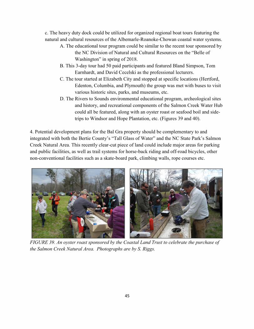
FIGURE 39. An oyster roast sponsored by the Coastal Land Trust to celebrate the purchase of the Salmon Creek Natural Area. Photographs are by S. Riggs.
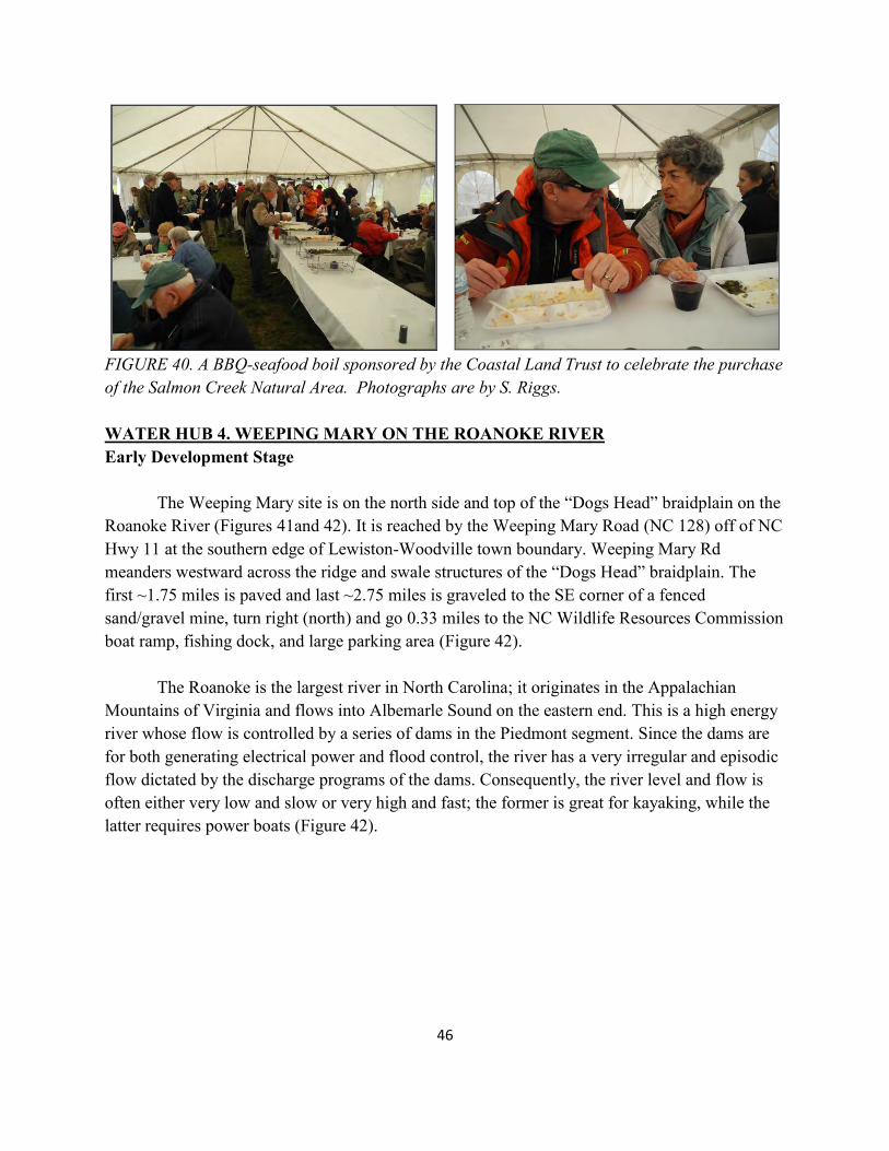
46
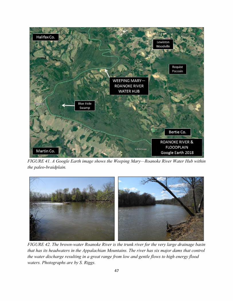
FIGURE 40. A BBQ-seafood boil sponsored by the Coastal Land Trust to celebrate the purchase of the Salmon Creek Natural Area. Photographs are by S. Riggs. WATER HUB 4. WEEPING MARY ON THE ROANOKE RIVER Early Development Stage The Weeping Mary site is on the north side and top of the “Dogs Head” braidplain on the Roanoke River (Figures 41and 42). It is reached by the Weeping Mary Road (NC 128) off of NC Hwy 11 at the southern edge of Lewiston-Woodville town boundary. Weeping Mary Rd meanders westward across the ridge and swale structures of the “Dogs Head” braidplain. The first ~1.75 miles is paved and last ~2.75 miles is graveled to the SE corner of a fenced sand/gravel mine, turn right (north) and go 0.33 miles to the NC Wildlife Resources Commission boat ramp, fishing dock, and large parking area (Figure 42). The Roanoke is the largest river in North Carolina; it originates in the Appalachian Mountains of Virginia and flows into Albemarle Sound on the eastern end. This is a high energy river whose flow is controlled by a series of dams in the Piedmont segment. Since the dams are for both generating electrical power and flood control, the river has a very irregular and episodic flow dictated by the discharge programs of the dams. Consequently, the river level and flow is often either very low and slow or very high and fast; the former is great for kayaking, while the latter requires power boats (Figure 42).
47
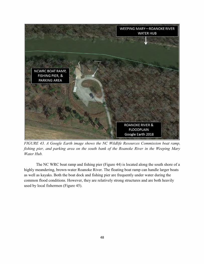
FIGURE 41. A Google Earth image shows the Weeping Mary—Roanoke River Water Hub within the paleo-braidplain.
FIGURE 42. The brown-water Roanoke River is the trunk river for the very large drainage basin that has its headwaters in the Appalachian Mountains. The river has six major dams that control the water discharge resulting in a great range from low and gentle flows to high energy flood waters. Photographs are by S. Riggs.
48
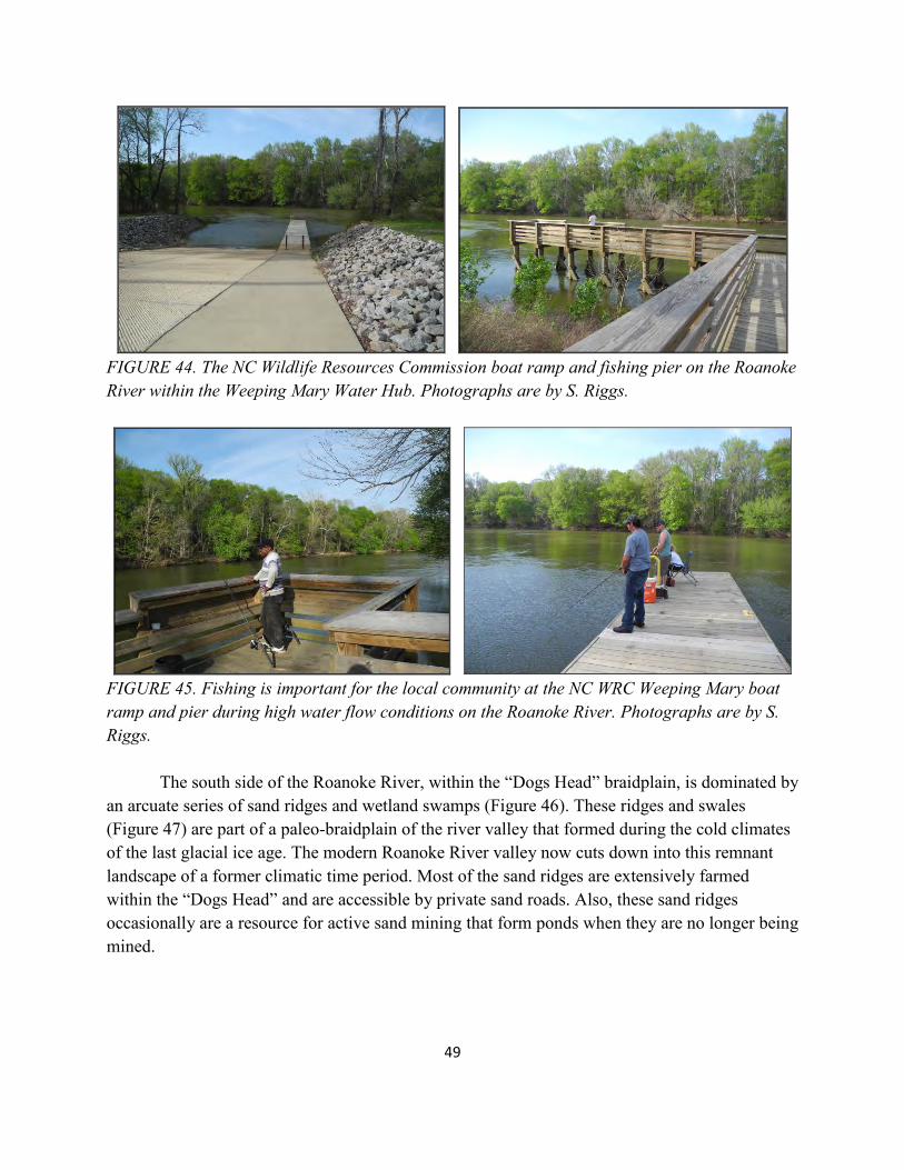
FIGURE 43. A Google Earth image shows the NC Wildlife Resources Commission boat ramp, fishing pier, and parking area on the south bank of the Roanoke River in the Weeping Mary Water Hub. The NC WRC boat ramp and fishing pier (Figure 44) is located along the south shore of a highly meandering, brown-water Roanoke River. The floating boat ramp can handle larger boats as well as kayaks. Both the boat dock and fishing pier are frequently under water during the common flood conditions. However, they are relatively strong structures and are both heavily used by local fishermen (Figure 45).
49
FIGURE 44. The NC Wildlife Resources Commission boat ramp and fishing pier on the Roanoke River within the Weeping Mary Water Hub. Photographs are by S. Riggs.
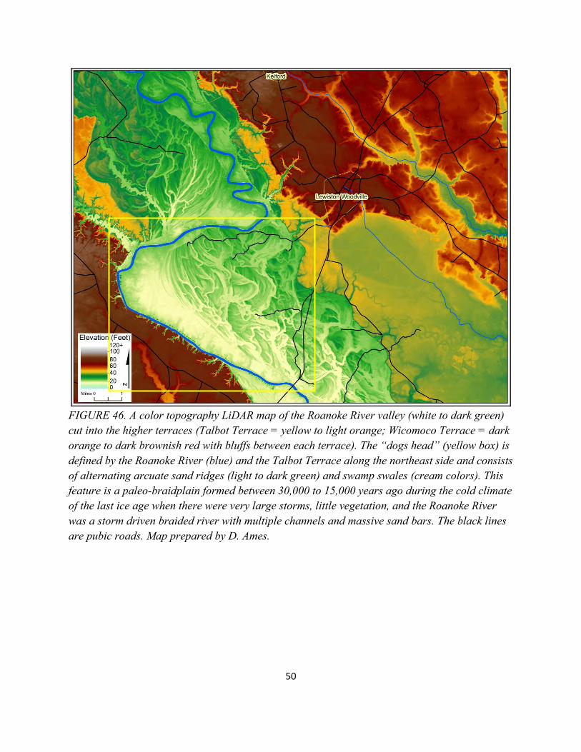
FIGURE 45. Fishing is important for the local community at the NC WRC Weeping Mary boat ramp and pier during high water flow conditions on the Roanoke River. Photographs are by S. Riggs. The south side of the Roanoke River, within the “Dogs Head” braidplain, is dominated by an arcuate series of sand ridges and wetland swamps (Figure 46). These ridges and swales (Figure 47) are part of a paleo-braidplain of the river valley that formed during the cold climates of the last glacial ice age. The modern Roanoke River valley now cuts down into this remnant landscape of a former climatic time period. Most of the sand ridges are extensively farmed within the “Dogs Head” and are accessible by private sand roads. Also, these sand ridges occasionally are a resource for active sand mining that form ponds when they are no longer being mined.
50
FIGURE 46. A color topography LiDAR map of the Roanoke River valley (white to dark green) cut into the higher terraces (Talbot Terrace = yellow to light orange; Wicomoco Terrace = dark orange to dark brownish red with bluffs between each terrace). The “dogs head” (yellow box) is defined by the Roanoke River (blue) and the Talbot Terrace along the northeast side and consists of alternating arcuate sand ridges (light to dark green) and swamp swales (cream colors). This feature is a paleo-braidplain formed between 30,000 to 15,000 years ago during the cold climate of the last ice age when there were very large storms, little vegetation, and the Roanoke River was a storm driven braided river with multiple channels and massive sand bars. The black lines are pubic roads. Map prepared by D. Ames.
51
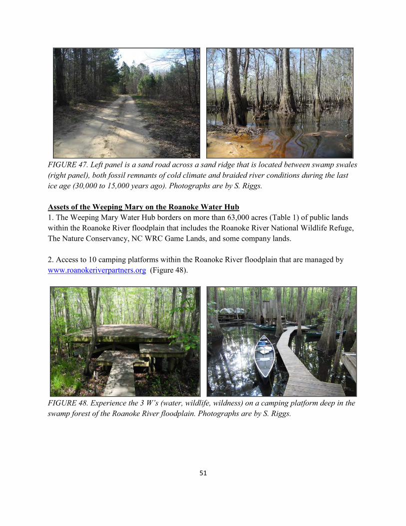
FIGURE 47. Left panel is a sand road across a sand ridge that is located between swamp swales (right panel), both fossil remnants of cold climate and braided river conditions during the last ice age (30,000 to 15,000 years ago). Photographs are by S. Riggs. Assets of the Weeping Mary on the Roanoke Water Hub 1. The Weeping Mary Water Hub borders on more than 63,000 acres (Table 1) of public lands within the Roanoke River floodplain that includes the Roanoke River National Wildlife Refuge, The Nature Conservancy, NC WRC Game Lands, and some company lands. 2. Access to 10 camping platforms within the Roanoke River floodplain that are managed by www.roanokeriverpartners.org (Figure 48).
FIGURE 48. Experience the 3 W’s (water, wildlife, wildness) on a camping platform deep in the swamp forest of the Roanoke River floodplain. Photographs are by S. Riggs.
52
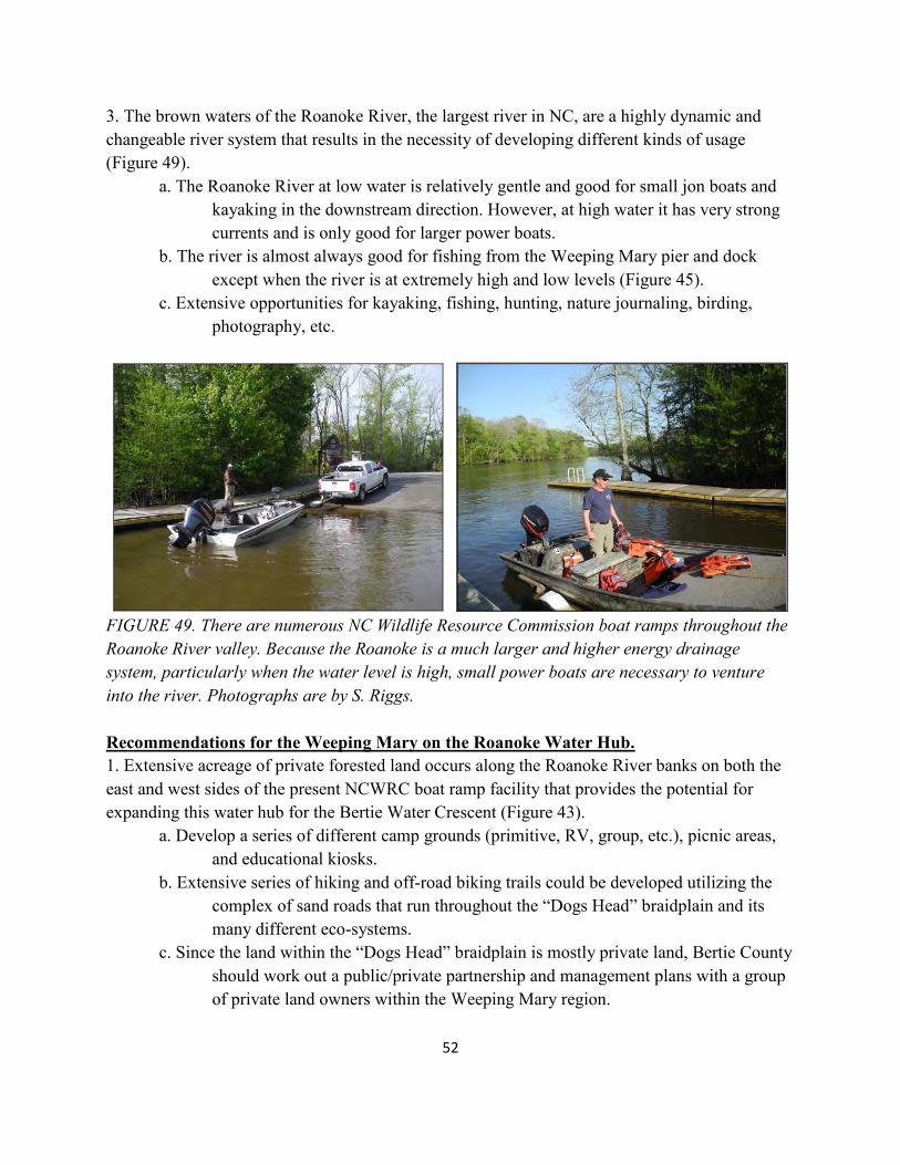
3. The brown waters of the Roanoke River, the largest river in NC, are a highly dynamic and changeable river system that results in the necessity of developing different kinds of usage (Figure 49).
a. The Roanoke River at low water is relatively gentle and good for small jon boats and kayaking in the downstream direction. However, at high water it has very strong currents and is only good for larger power boats. b. The river is almost always good for fishing from the Weeping Mary pier and dock except when the river is at extremely high and low levels (Figure 45). c. Extensive opportunities for kayaking, fishing, hunting, nature journaling, birding, photography, etc.
FIGURE 49. There are numerous NC Wildlife Resource Commission boat ramps throughout the Roanoke River valley. Because the Roanoke is a much larger and higher energy drainage system, particularly when the water level is high, small power boats are necessary to venture into the river. Photographs are by S. Riggs. Recommendations for the Weeping Mary on the Roanoke Water Hub. 1. Extensive acreage of private forested land occurs along the Roanoke River banks on both the east and west sides of the present NCWRC boat ramp facility that provides the potential for expanding this water hub for the Bertie Water Crescent (Figure 43). a. Develop a series of different camp grounds (primitive, RV, group, etc.), picnic areas, and educational kiosks. b. Extensive series of hiking and off-road biking trails could be developed utilizing the complex of sand roads that run throughout the “Dogs Head” braidplain and its many different eco-systems. c. Since the land within the “Dogs Head” braidplain is mostly private land, Bertie County should work out a public/private partnership and management plans with a group of private land owners within the Weeping Mary region.
53
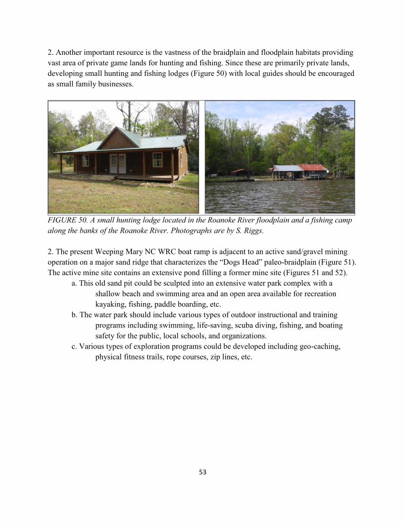
2. Another important resource is the vastness of the braidplain and floodplain habitats providing vast area of private game lands for hunting and fishing. Since these are primarily private lands, developing small hunting and fishing lodges (Figure 50) with local guides should be encouraged as small family businesses.
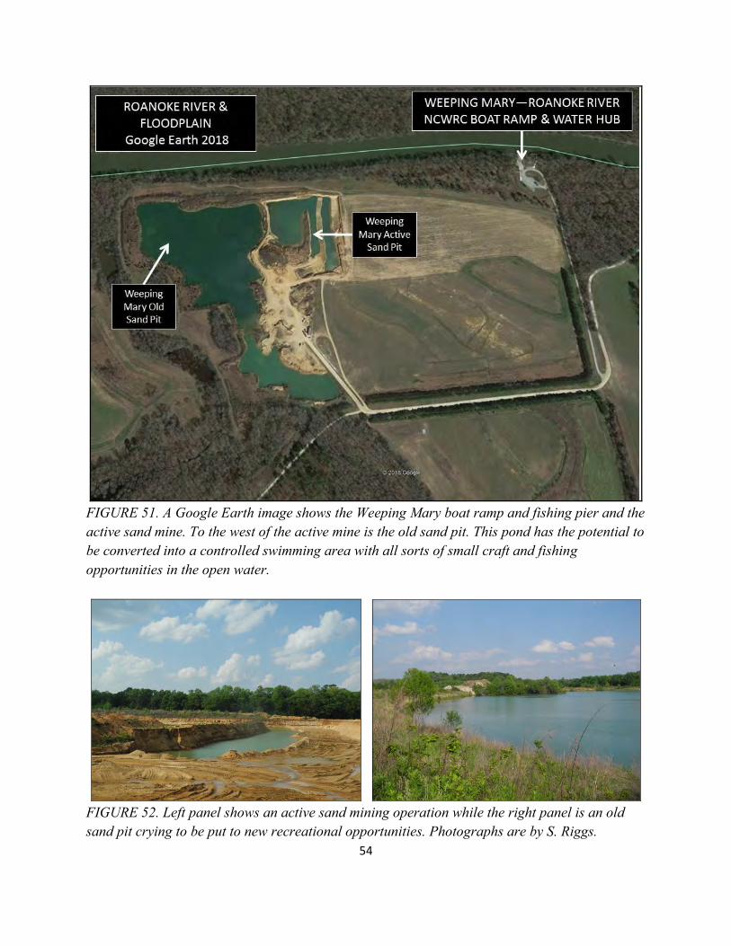
FIGURE 50. A small hunting lodge located in the Roanoke River floodplain and a fishing camp along the banks of the Roanoke River. Photographs are by S. Riggs. 2. The present Weeping Mary NC WRC boat ramp is adjacent to an active sand/gravel mining operation on a major sand ridge that characterizes the “Dogs Head” paleo-braidplain (Figure 51). The active mine site contains an extensive pond filling a former mine site (Figures 51 and 52). a. This old sand pit could be sculpted into an extensive water park complex with a shallow beach and swimming area and an open area available for recreation kayaking, fishing, paddle boarding, etc. b. The water park should include various types of outdoor instructional and training programs including swimming, life-saving, scuba diving, fishing, and boating safety for the public, local schools, and organizations. c. Various types of exploration programs could be developed including geo-caching, physical fitness trails, rope courses, zip lines, etc.
54
FIGURE 51. A Google Earth image shows the Weeping Mary boat ramp and fishing pier and the active sand mine. To the west of the active mine is the old sand pit. This pond has the potential to be converted into a controlled swimming area with all sorts of small craft and fishing opportunities in the open water.
FIGURE 52. Left panel shows an active sand mining operation while the right panel is an old sand pit crying to be put to new recreational opportunities. Photographs are by S. Riggs.
55
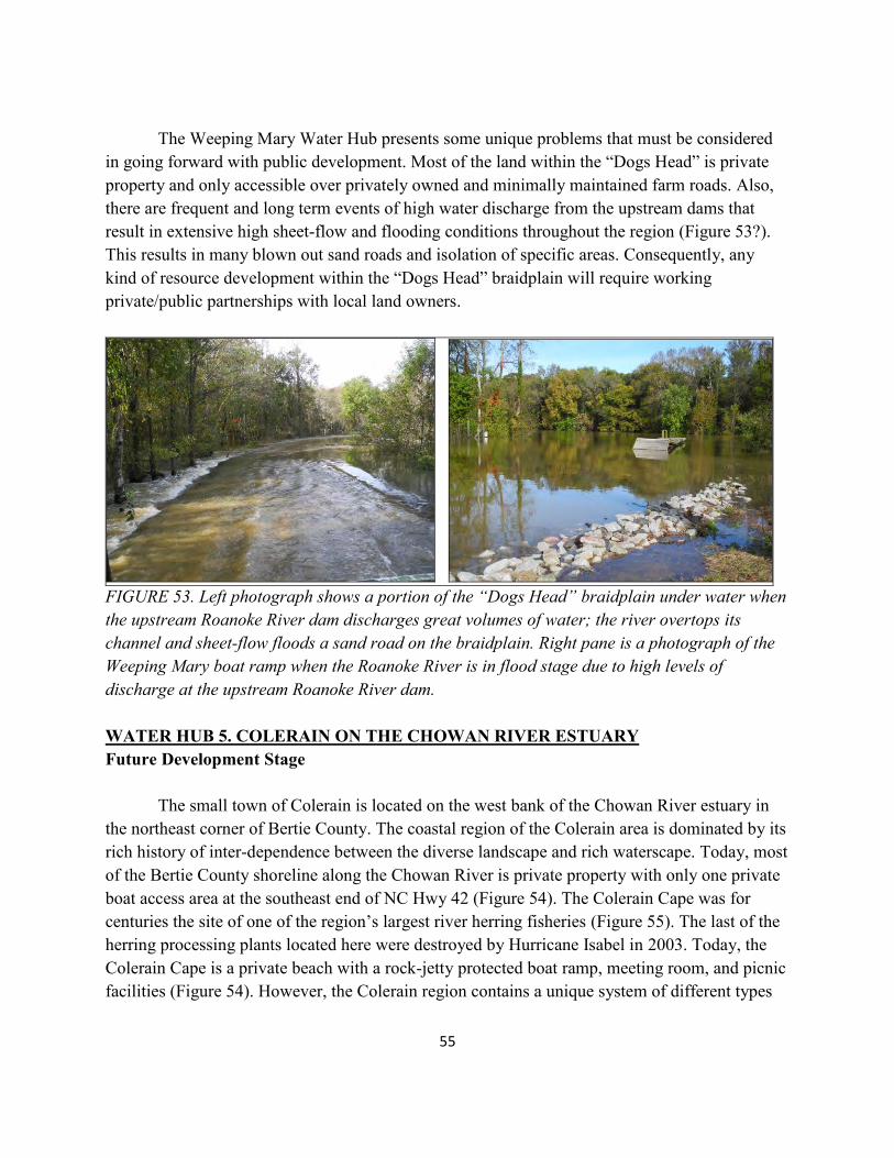
The Weeping Mary Water Hub presents some unique problems that must be considered in going forward with public development. Most of the land within the “Dogs Head” is private property and only accessible over privately owned and minimally maintained farm roads. Also, there are frequent and long term events of high water discharge from the upstream dams that result in extensive high sheet-flow and flooding conditions throughout the region (Figure 53?). This results in many blown out sand roads and isolation of specific areas. Consequently, any kind of resource development within the “Dogs Head” braidplain will require working private/public partnerships with local land owners.
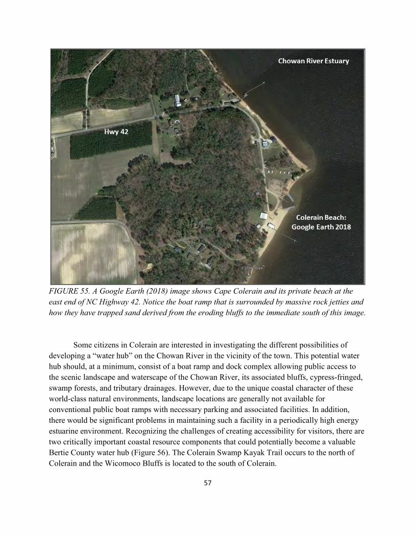
FIGURE 53. Left photograph shows a portion of the “Dogs Head” braidplain under water when the upstream Roanoke River dam discharges great volumes of water; the river overtops its channel and sheet-flow floods a sand road on the braidplain. Right pane is a photograph of the Weeping Mary boat ramp when the Roanoke River is in flood stage due to high levels of discharge at the upstream Roanoke River dam. WATER HUB 5. COLERAIN ON THE CHOWAN RIVER ESTUARY Future Development Stage The small town of Colerain is located on the west bank of the Chowan River estuary in the northeast corner of Bertie County. The coastal region of the Colerain area is dominated by its rich history of inter-dependence between the diverse landscape and rich waterscape. Today, most of the Bertie County shoreline along the Chowan River is private property with only one private boat access area at the southeast end of NC Hwy 42 (Figure 54). The Colerain Cape was for centuries the site of one of the region’s largest river herring fisheries (Figure 55). The last of the herring processing plants located here were destroyed by Hurricane Isabel in 2003. Today, the Colerain Cape is a private beach with a rock-jetty protected boat ramp, meeting room, and picnic facilities (Figure 54). However, the Colerain region contains a unique system of different types
56
of water bodies that make it an important location for establishing a major “water hub” for the “Bertie Water Crescent”.
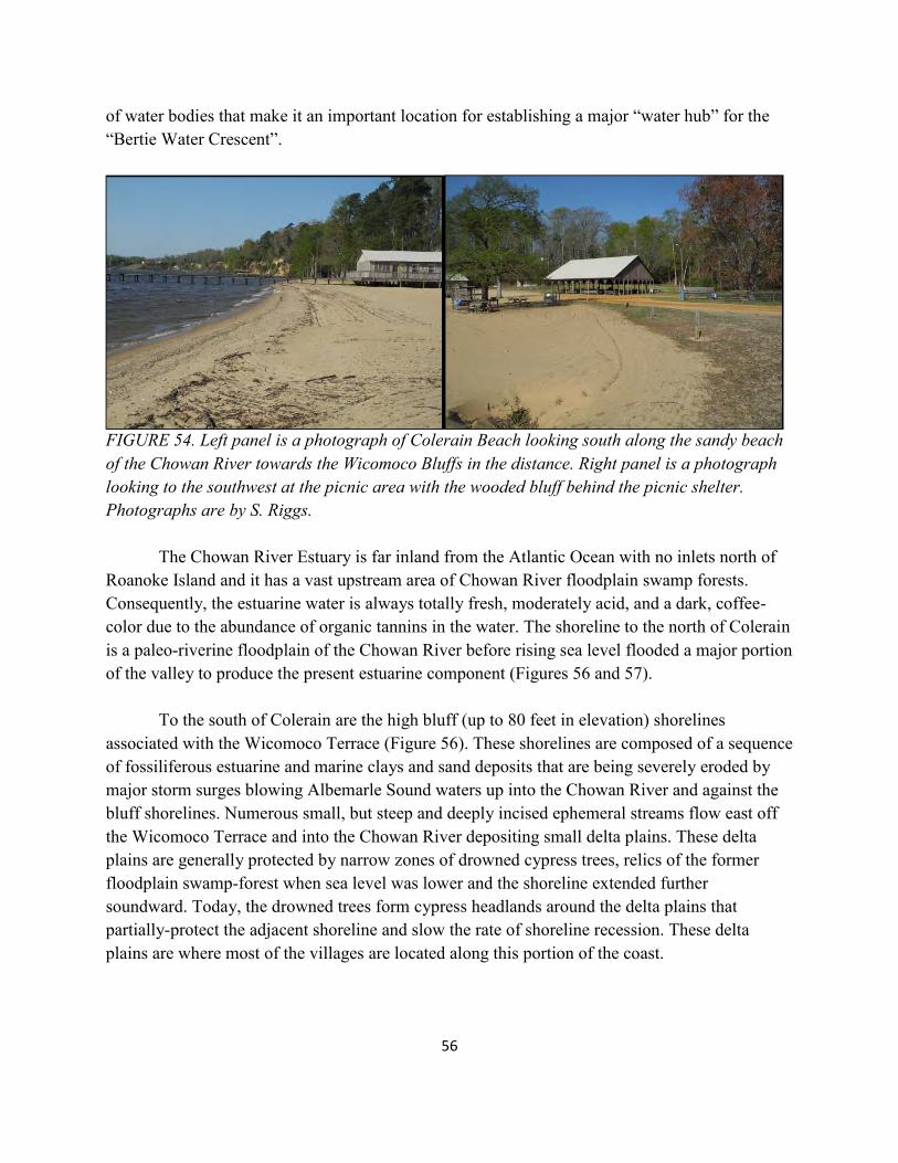
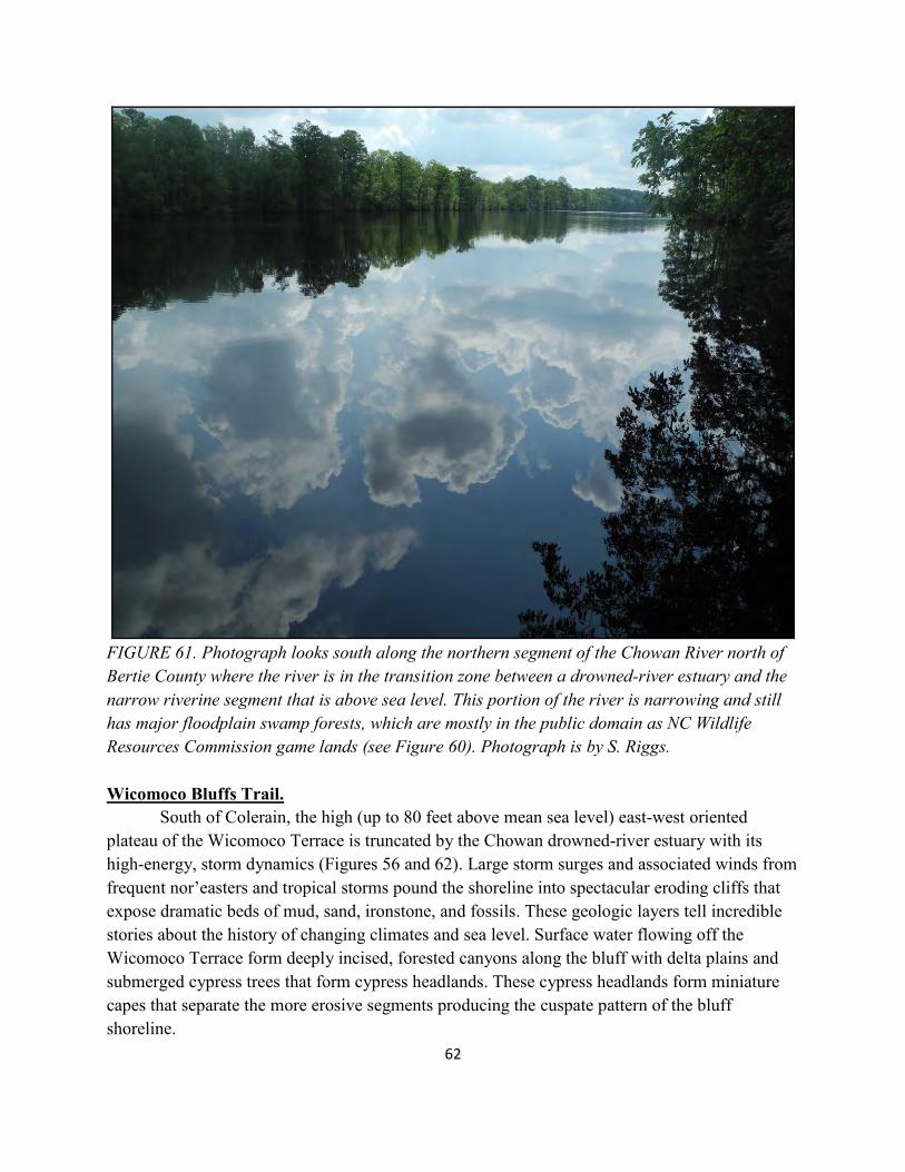
FIGURE 54. Left panel is a photograph of Colerain Beach looking south along the sandy beach of the Chowan River towards the Wicomoco Bluffs in the distance. Right panel is a photograph looking to the southwest at the picnic area with the wooded bluff behind the picnic shelter. Photographs are by S. Riggs. The Chowan River Estuary is far inland from the Atlantic Ocean with no inlets north of Roanoke Island and it has a vast upstream area of Chowan River floodplain swamp forests. Consequently, the estuarine water is always totally fresh, moderately acid, and a dark, coffee-color due to the abundance of organic tannins in the water. The shoreline to the north of Colerain is a paleo-riverine floodplain of the Chowan River before rising sea level flooded a major portion of the valley to produce the present estuarine component (Figures 56 and 57). To the south of Colerain are the high bluff (up to 80 feet in elevation) shorelines associated with the Wicomoco Terrace (Figure 56). These shorelines are composed of a sequence of fossiliferous estuarine and marine clays and sand deposits that are being severely eroded by major storm surges blowing Albemarle Sound waters up into the Chowan River and against the bluff shorelines. Numerous small, but steep and deeply incised ephemeral streams flow east off the Wicomoco Terrace and into the Chowan River depositing small delta plains. These delta plains are generally protected by narrow zones of drowned cypress trees, relics of the former floodplain swamp-forest when sea level was lower and the shoreline extended further soundward. Today, the drowned trees form cypress headlands around the delta plains that partially-protect the adjacent shoreline and slow the rate of shoreline recession. These delta plains are where most of the villages are located along this portion of the coast.
57
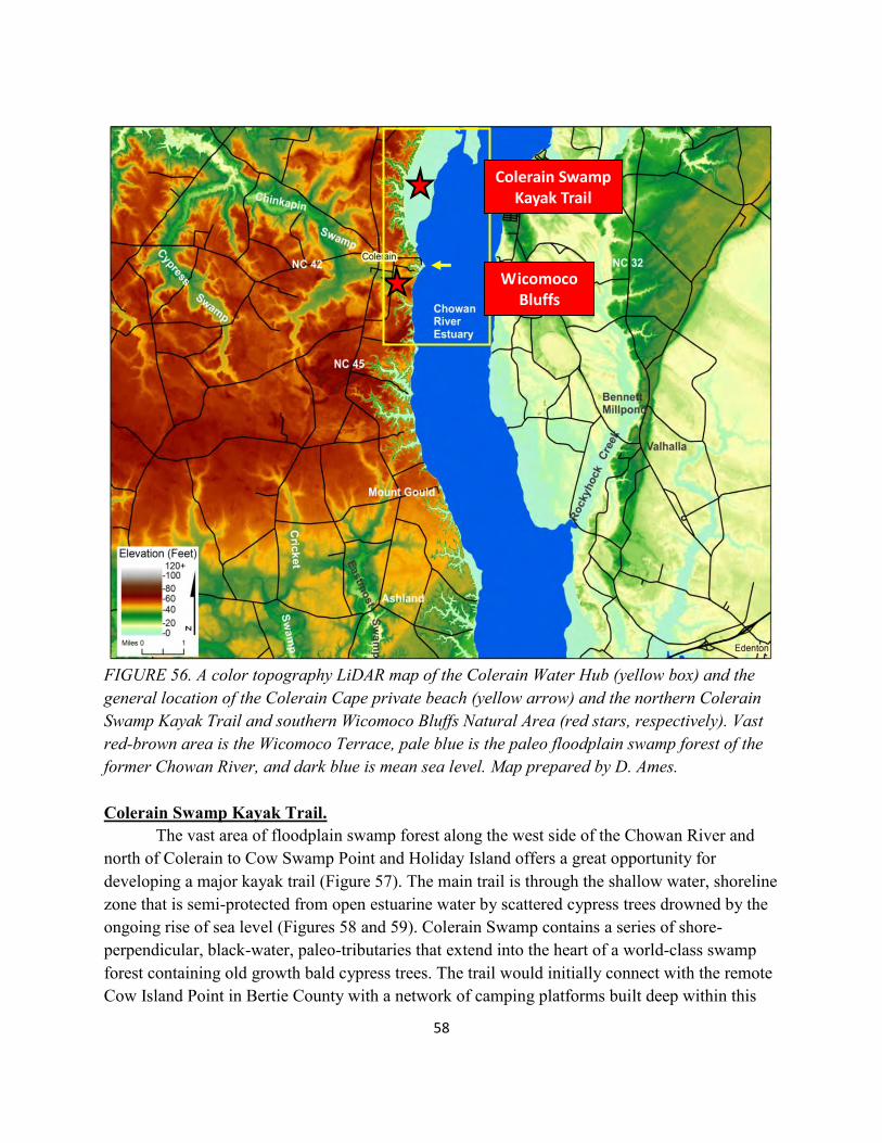
FIGURE 55. A Google Earth (2018) image shows Cape Colerain and its private beach at the east end of NC Highway 42. Notice the boat ramp that is surrounded by massive rock jetties and how they have trapped sand derived from the eroding bluffs to the immediate south of this image. Some citizens in Colerain are interested in investigating the different possibilities of developing a “water hub” on the Chowan River in the vicinity of the town. This potential water hub should, at a minimum, consist of a boat ramp and dock complex allowing public access to the scenic landscape and waterscape of the Chowan River, its associated bluffs, cypress-fringed, swamp forests, and tributary drainages. However, due to the unique coastal character of these world-class natural environments, landscape locations are generally not available for conventional public boat ramps with necessary parking and associated facilities. In addition, there would be significant problems in maintaining such a facility in a periodically high energy estuarine environment. Recognizing the challenges of creating accessibility for visitors, there are two critically important coastal resource components that could potentially become a valuable Bertie County water hub (Figure 56). The Colerain Swamp Kayak Trail occurs to the north of Colerain and the Wicomoco Bluffs is located to the south of Colerain.
58
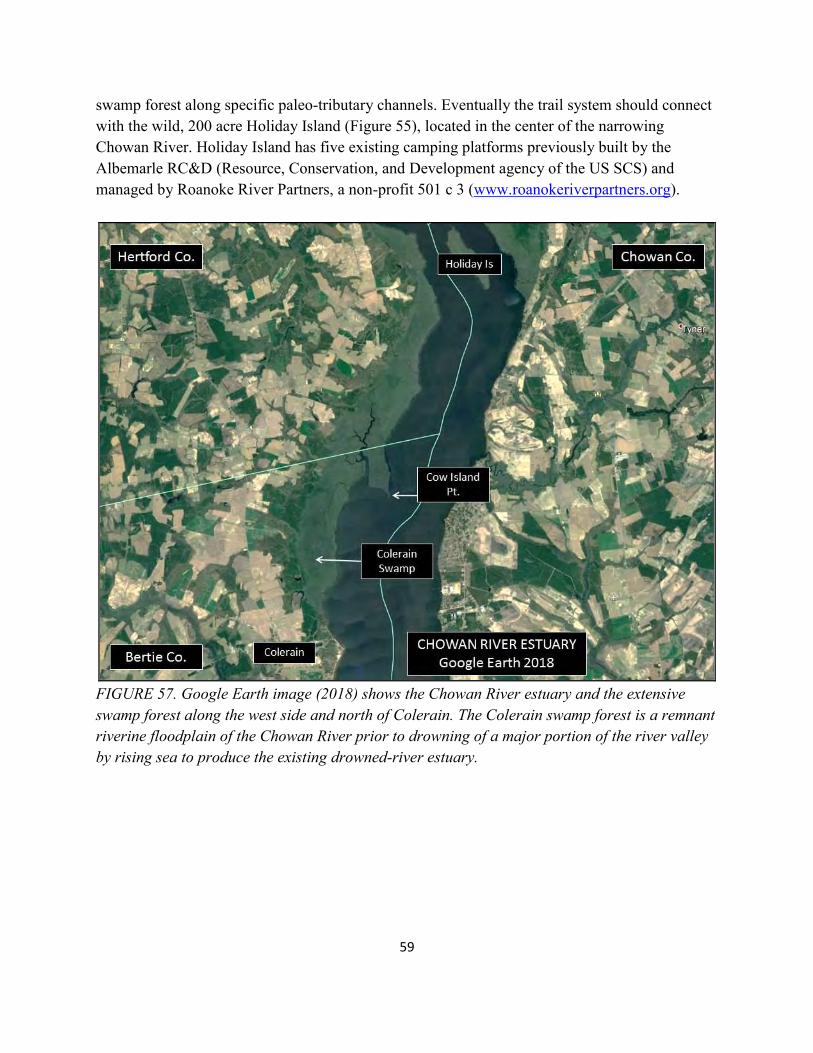
FIGURE 56. A color topography LiDAR map of the Colerain Water Hub (yellow box) and the general location of the Colerain Cape private beach (yellow arrow) and the northern Colerain Swamp Kayak Trail and southern Wicomoco Bluffs Natural Area (red stars, respectively). Vast red-brown area is the Wicomoco Terrace, pale blue is the paleo floodplain swamp forest of the former Chowan River, and dark blue is mean sea level. Map prepared by D. Ames. Colerain Swamp Kayak Trail. The vast area of floodplain swamp forest along the west side of the Chowan River and north of Colerain to Cow Swamp Point and Holiday Island offers a great opportunity for developing a major kayak trail (Figure 57). The main trail is through the shallow water, shoreline zone that is semi-protected from open estuarine water by scattered cypress trees drowned by the ongoing rise of sea level (Figures 58 and 59). Colerain Swamp contains a series of shore-perpendicular, black-water, paleo-tributaries that extend into the heart of a world-class swamp forest containing old growth bald cypress trees. The trail would initially connect with the remote Cow Island Point in Bertie County with a network of camping platforms built deep within this
Wicomoco Bluffs
Colerain Swamp Kayak Trail
59
swamp forest along specific paleo-tributary channels. Eventually the trail system should connect with the wild, 200 acre Holiday Island (Figure 55), located in the center of the narrowing Chowan River. Holiday Island has five existing camping platforms previously built by the Albemarle RC&D (Resource, Conservation, and Development agency of the US SCS) and managed by Roanoke River Partners, a non-profit 501 c 3 (www.roanokeriverpartners.org).
FIGURE 57. Google Earth image (2018) shows the Chowan River estuary and the extensive swamp forest along the west side and north of Colerain. The Colerain swamp forest is a remnant riverine floodplain of the Chowan River prior to drowning of a major portion of the river valley by rising sea to produce the existing drowned-river estuary.
60
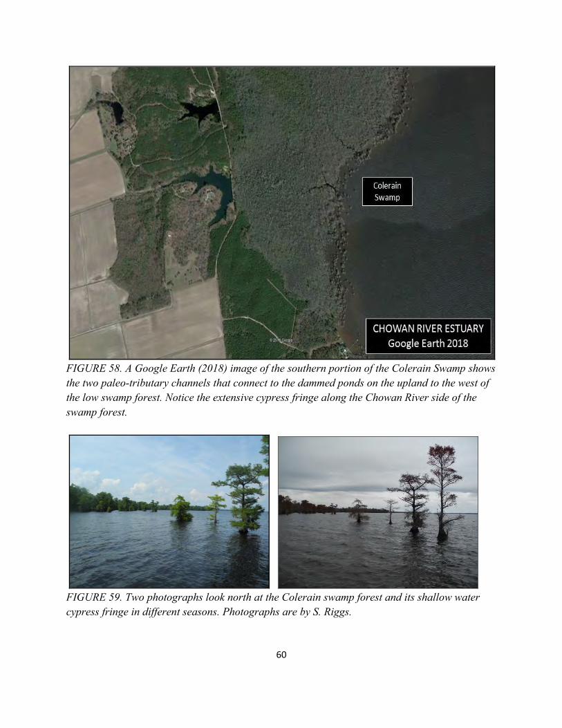
FIGURE 58. A Google Earth (2018) image of the southern portion of the Colerain Swamp shows the two paleo-tributary channels that connect to the dammed ponds on the upland to the west of the low swamp forest. Notice the extensive cypress fringe along the Chowan River side of the swamp forest.
FIGURE 59. Two photographs look north at the Colerain swamp forest and its shallow water cypress fringe in different seasons. Photographs are by S. Riggs.
61
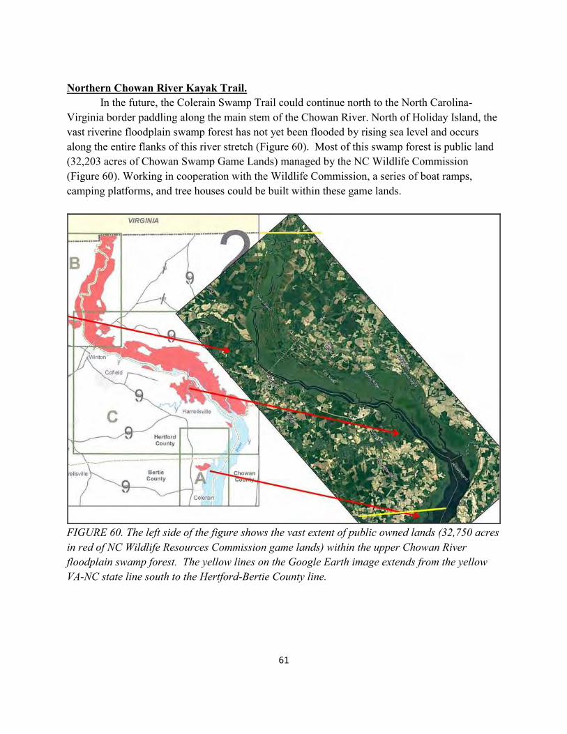
Northern Chowan River Kayak Trail. In the future, the Colerain Swamp Trail could continue north to the North Carolina-Virginia border paddling along the main stem of the Chowan River. North of Holiday Island, the vast riverine floodplain swamp forest has not yet been flooded by rising sea level and occurs along the entire flanks of this river stretch (Figure 60). Most of this swamp forest is public land (32,203 acres of Chowan Swamp Game Lands) managed by the NC Wildlife Commission (Figure 60). Working in cooperation with the Wildlife Commission, a series of boat ramps, camping platforms, and tree houses could be built within these game lands.
FIGURE 60. The left side of the figure shows the vast extent of public owned lands (32,750 acres in red of NC Wildlife Resources Commission game lands) within the upper Chowan River floodplain swamp forest. The yellow lines on the Google Earth image extends from the yellow VA-NC state line south to the Hertford-Bertie County line.
62
FIGURE 61. Photograph looks south along the northern segment of the Chowan River north of Bertie County where the river is in the transition zone between a drowned-river estuary and the narrow riverine segment that is above sea level. This portion of the river is narrowing and still has major floodplain swamp forests, which are mostly in the public domain as NC Wildlife Resources Commission game lands (see Figure 60). Photograph is by S. Riggs. Wicomoco Bluffs Trail. South of Colerain, the high (up to 80 feet above mean sea level) east-west oriented plateau of the Wicomoco Terrace is truncated by the Chowan drowned-river estuary with its high-energy, storm dynamics (Figures 56 and 62). Large storm surges and associated winds from frequent nor’easters and tropical storms pound the shoreline into spectacular eroding cliffs that expose dramatic beds of mud, sand, ironstone, and fossils. These geologic layers tell incredible stories about the history of changing climates and sea level. Surface water flowing off the Wicomoco Terrace form deeply incised, forested canyons along the bluff with delta plains and submerged cypress trees that form cypress headlands. These cypress headlands form miniature capes that separate the more erosive segments producing the cuspate pattern of the bluff shoreline.
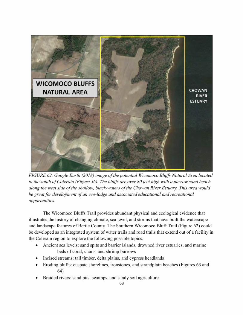
63
FIGURE 62. Google Earth (2018) image of the potential Wicomoco Bluffs Natural Area located to the south of Colerain (Figure 56). The bluffs are over 80 feet high with a narrow sand beach along the west side of the shallow, black-waters of the Chowan River Estuary. This area would be great for development of an eco-lodge and associated educational and recreational opportunities. The Wicomoco Bluffs Trail provides abundant physical and ecological evidence that illustrates the history of changing climate, sea level, and storms that have built the waterscape and landscape features of Bertie County. The Southern Wicomoco Bluff Trail (Figure 62) could be developed as an integrated system of water trails and road trails that extend out of a facility in the Colerain region to explore the following possible topics.
Ancient sea levels: sand spits and barrier islands, drowned river estuaries, and marine beds of coral, clams, and shrimp burrows
Incised streams: tall timber, delta plains, and cypress headlands Eroding bluffs: cuspate shorelines, ironstones, and strandplain beaches (Figures 63 and
64) Braided rivers: sand pits, swamps, and sandy soil agriculture
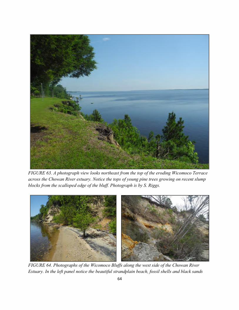
64
FIGURE 63. A photograph view looks northeast from the top of the eroding Wicomoco Terrace across the Chowan River estuary. Notice the tops of young pine trees growing on recent slump blocks from the scalloped edge of the bluff. Photograph is by S. Riggs.
FIGURE 64. Photographs of the Wicomoco Bluffs along the west side of the Chowan River Estuary. In the left panel notice the beautiful strandplain beach, fossil shells and black sands
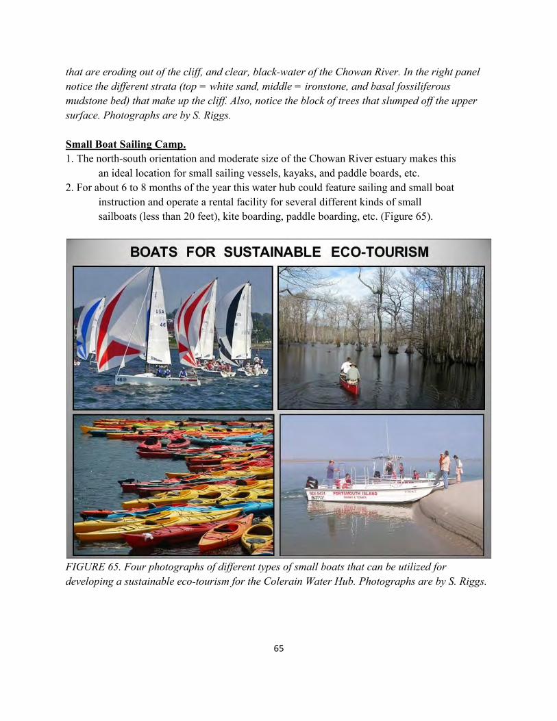
65
that are eroding out of the cliff, and clear, black-water of the Chowan River. In the right panel notice the different strata (top = white sand, middle = ironstone, and basal fossiliferous mudstone bed) that make up the cliff. Also, notice the block of trees that slumped off the upper surface. Photographs are by S. Riggs. Small Boat Sailing Camp. 1. The north-south orientation and moderate size of the Chowan River estuary makes this an ideal location for small sailing vessels, kayaks, and paddle boards, etc. 2. For about 6 to 8 months of the year this water hub could feature sailing and small boat instruction and operate a rental facility for several different kinds of small sailboats (less than 20 feet), kite boarding, paddle boarding, etc. (Figure 65).
FIGURE 65. Four photographs of different types of small boats that can be utilized for developing a sustainable eco-tourism for the Colerain Water Hub. Photographs are by S. Riggs.
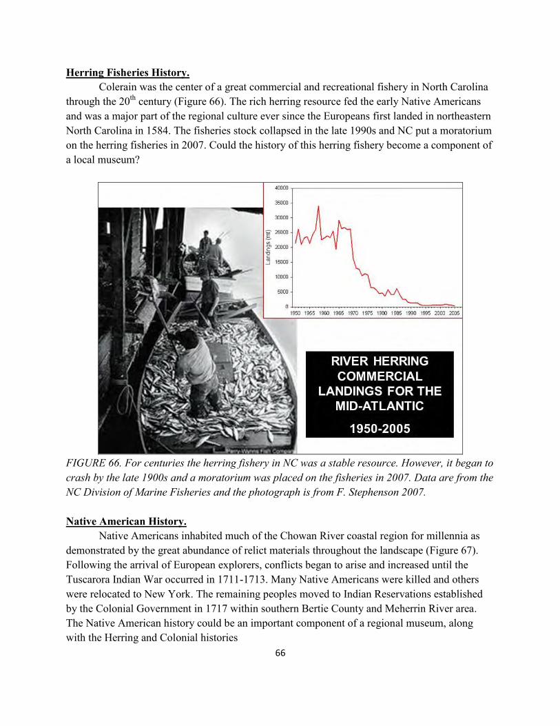
66
Herring Fisheries History. Colerain was the center of a great commercial and recreational fishery in North Carolina through the 20th century (Figure 66). The rich herring resource fed the early Native Americans and was a major part of the regional culture ever since the Europeans first landed in northeastern North Carolina in 1584. The fisheries stock collapsed in the late 1990s and NC put a moratorium on the herring fisheries in 2007. Could the history of this herring fishery become a component of a local museum?
FIGURE 66. For centuries the herring fishery in NC was a stable resource. However, it began to crash by the late 1900s and a moratorium was placed on the fisheries in 2007. Data are from the NC Division of Marine Fisheries and the photograph is from F. Stephenson 2007. Native American History. Native Americans inhabited much of the Chowan River coastal region for millennia as demonstrated by the great abundance of relict materials throughout the landscape (Figure 67). Following the arrival of European explorers, conflicts began to arise and increased until the Tuscarora Indian War occurred in 1711-1713. Many Native Americans were killed and others were relocated to New York. The remaining peoples moved to Indian Reservations established by the Colonial Government in 1717 within southern Bertie County and Meherrin River area. The Native American history could be an important component of a regional museum, along with the Herring and Colonial histories
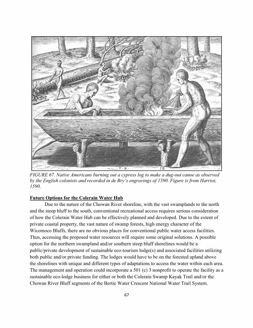
67
FIGURE 67. Native Americans burning out a cypress log to make a dug-out canoe as observed by the English colonists and recorded in de Bry’s engravings of 1590. Figure is from Harriot, 1590. Future Options for the Colerain Water Hub Due to the nature of the Chowan River shoreline, with the vast swamplands to the north and the steep bluff to the south, conventional recreational access requires serious consideration of how the Colerain Water Hub can be effectively planned and developed. Due to the extent of private coastal property, the vast nature of swamp forests, high energy character of the Wicomoco Bluffs, there are no obvious places for conventional public water access facilities. Thus, accessing the proposed water resources will require some original solutions. A possible option for the northern swampland and/or southern steep bluff shorelines would be a public/private development of sustainable eco-tourism lodge(s) and associated facilities utilizing both public and/or private funding. The lodges would have to be on the forested upland above the shorelines with unique and different types of adaptations to access the water within each area. The management and operation could incorporate a 501 (c) 3 nonprofit to operate the facility as a sustainable eco-lodge business for either or both the Colerain Swamp Kayak Trail and/or the Chowan River Bluff segments of the Bertie Water Crescent National Water Trail System.
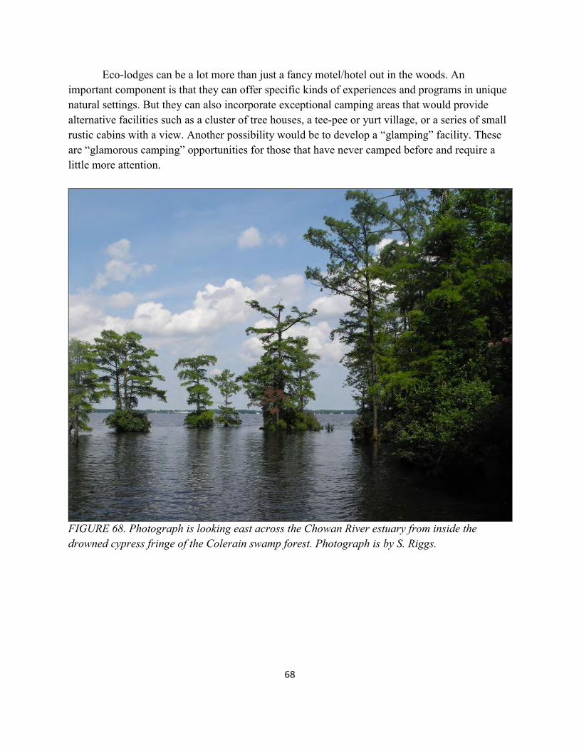
68
Eco-lodges can be a lot more than just a fancy motel/hotel out in the woods. An important component is that they can offer specific kinds of experiences and programs in unique natural settings. But they can also incorporate exceptional camping areas that would provide alternative facilities such as a cluster of tree houses, a tee-pee or yurt village, or a series of small rustic cabins with a view. Another possibility would be to develop a “glamping” facility. These are “glamorous camping” opportunities for those that have never camped before and require a little more attention.
FIGURE 68. Photograph is looking east across the Chowan River estuary from inside the drowned cypress fringe of the Colerain swamp forest. Photograph is by S. Riggs.
69
SUMMARY: FROM RIVERS TO SOUNDS The natural and human history within North Carolina’s Land of Water (NC LOW) is a product of the continual interplay of the geological, ecological, and human processes operating in this dynamic coastal system. Northeastern NC’s coastal system is a complex network of interdependent ecosystems dominated by changes resulting from ongoing processes of sea-level rise and recurrent, high-energy storms. These energetic processes of change have molded North Carolina’s human history, continue to significantly impact the present culture, and will have a heavy imprint on our future coastal culture and economy. Thus, the “From Rivers to Sounds” program reflects a water-based, environmental history of a small coastal region through millennia of coastal system change and evolution with a substantial cultural over-print on the landscapes, their ecosystems, and natural dynamics.
Small towns in North Carolina’s Land of Water are hard-pressed to create new economic opportunities. Today they face major challenges that include destructive floods, rising sea level, loss of jobs, population declines, high poverty rates, and crumbling infrastructure. In an effort to stimulate new economic opportunities, NC LOW’s strategy is to focus on the natural and cultural, resource-based eco-tourism and environmental education as a means of diversifying the rural economy while minimizing the stifling impact of flooding and drought. NC LOW brings this vision to the Bertie County region with the expectation of improving the local quality of life through sustainable economic development that enhances and protects the environment and culture of the region. Bertie County is water-bound by a complex of different kinds of drainage systems encircling three sides of the county and dissecting it through the interior. The great Roanoke River forms the entire western and southern boundary, while the estuarine waters of Albemarle Sound and the Chowan River embayed estuary forms the southeastern and entire eastern boundary, respectively. The interior of Bertie County is dominated by the dendritic valley of the Cashie River and its upstream tributary network and downstream inputs from Roquist and Wadling Place creeks. Several smaller and incised, black-water tributary streams flow into Albemarle Sound and include the Salmon, Black Walnut, and Cashoke creeks. The high, east-facing bluffs of the Wicomoco and Talbot Terraces contain numerous small, steep, and deeply incised, ephemeral drainages characterized by small delta plains and cypress headlands where they discharge into the Chowan River and Albemarle Sound. Bertie County’s unique and world-class water system represents a two-pronged future for its citizens. The diverse and vast character of natural and cultural resources can provide the framework for a new “From Rivers to Sounds” program that focuses on regional environmental education and forms the basis for a sustainable eco-tourism economy. In order to develop this eco-tourism economy, environmental education is essential to grow an educated citizenry in
70
order to maintain a healthy environment and to cultivate and train local personnel for new career opportunities within the Bertie waterscape. Eco-tourism has the potential to provide important economic benefits with an influx of new travelers visiting the region resulting in increased spending, new local businesses and jobs, and development sensitive to the ecology and culture of coastal eco-systems. Thus, an important goal is to educate stakeholders about the advantages of sustainable eco-tourism development and how to balance economic revitalization with the 3-Ps (preservation, protection, and presentation) of Bertie County’s natural resources and cultural history.
The Town of Windsor has been on the cutting edge of eco-tourism planning and paddle trail development for several decades. The tree house project speaks volumes regarding the Town Board’s vision for creating an attractive destination to compliment the natural beauty of the Cashie River. Also, the Bertie County Board of Commissioners set its strategic goals for economic development beginning in 2014 that included 1) public recreational access to the boundary waters of the County and 2) promotion of eco-tourism. The County’s governing body supported these economic development priorities and invested county funds to match a $500,000 grant from NC Parks and Recreation Trust Fund to acquire the 137 acre tract on Albemarle Sound known as the “Tall Glass of Water” project.
Efforts by the two elected bodies (Town Board of Windsor and Bertie Board of Commissioners) demonstrate the vision and willingness to work collaboratively on a regional basis. In addition, the NC Partnership for the Sounds, NC Coastal Land Trust, NC Clean Water Trust Fund, and NC Land of Water have all cooperated with and been major supporters of this vision. One result is acquisition of the Salmon Creek Natural Area (995 acres) and the potential acquisition of the Bal Gra tract (300 acres in progress), along with the county’s land (137 acres), to establish the anchor location on the nose of the Bertie Peninsula. This 1,432 acre eco-tourism and environmental education facility at the confluence of Albemarle Sound, Chowan River Estuary, Salmon Creek, and the Roanoke-Cashie River systems will become one of the five crown jewels that constitute the five water-hub system. This NC LOW report titled “Rivers to Sounds” lays the ground work for establishing five water hubs, which in turn provides the foundation for the possible designation as the Bertie Water Crescent National Water Trail System. Obtaining this national recognition from the US National Park Service would provide a national marketing tool for the unparalleled natural beauty and eco-tourism opportunities within the “Bertie Water Crescent”.
In order to realize this dream, the Bertie County leadership and her many towns, businesses, and citizenry must work in unison to support a totally integrated approach to defining its sustainable eco-tourism future. This will require public buy in, developing public/private partnerships, forming appropriate organizing committees. A critical component will be the acquisition of a lead person to oversee the various citizen committees, to define and prioritize the
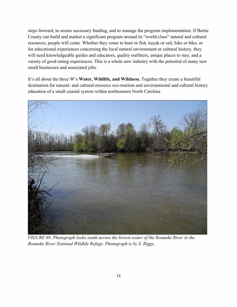
71
steps forward, to secure necessary funding, and to manage the program implementation. If Bertie County can build and market a significant program around its “world-class” natural and cultural resources, people will come. Whether they come to hunt or fish, kayak or sail, hike or bike, or for educational experiences concerning the local natural environment or cultural history, they will need knowledgeable guides and educators, quality outfitters, unique places to stay, and a variety of good eating experiences. This is a whole new industry with the potential of many new small businesses and associated jobs.
It’s all about the three W’s Water, Wildlife, and Wildness. Together they create a beautiful destination for natural- and cultural-resource eco-tourism and environmental and cultural history education of a small coastal system within northeastern North Carolina.
FIGURE 69. Photograph looks south across the brown-water of the Roanoke River in the Roanoke River National Wildlife Refuge. Photograph is by S. Riggs.