Embed Size (px)
DESCRIPTION
Â
Citation preview

© Create Design Ltd
Foxholes Site Stokesheath Road, Elmbridge, KT22 0PP Design and Access Statement – April 2014
Prepared by For and on behalf of
Littleworth Properties

© Create Design Ltd
_________________________________ 1.0 Introduction 2.0 Executive summary 3.0 Background and existing site context 4.0 Design brief 5.0 Use and quantum 6.0 Scale and mass 7.0 Appearance and materials 8.0 Landscape, access and Energy 9.0 Concluding summary __________________________________
Contents

© Create Design Ltd
1.0 Introduction
This Design and Access statement has been prepared by Create Design Ltd on behalf of Littleworth Properties Ltd in support of the planning application for the demolition of the existing single family dwelling on site and the construction of two new single family dwellings with associated external amenity space and parking provision. The site is not in a conservation area, it is not in the green belt, there are no TPO’s on site and the site is not at risk of flooding. The building is not listed and there are no nearby listed buildings. Several similar applications have been granted in recent years in the surrounding area. An application for outline planning permission for two new residential dwellings for this site was originally granted in 1989 and renewed several times up to application 2005/0853. This report outlines some of the key issues and relevant policies that will inform this proposal.
N

© Create Design Ltd
2.0 Executive Summary
The application site currently contains a single residential dwelling. This application proposes to demolish the existing house on site and replace it with two new residential dwellings. The surrounding area is characterised by dwellings that are similar in size to the ones that we propose. The existing house on site is significantly smaller than the majority of the neighbouring houses. In general the local area is characterised by large houses with attached garages and some, especially the newer houses, have accommodation in the roof space. The prevailing vernacular is houses that are set back from Stokesheath Road by anywhere between 10m and 40m and of seemingly randomised orientations. Our proposals are in line with the local characteristics of the surrounding area.

© Create Design Ltd
3.0 Background and Existing Site Context Local Area
Wilton House and Heathridge House – formerly a single plot (2001/2413)
The local area is characterised by large single family dwellings with large set-backs from the street, large gardens and attached garages. The existing dwelling at Foxholes is undersized for the site and is out of keeping with the local vernacular. Property boundaries are often planted or heavily wooded. This provides a level of privacy and filters views between adjacent properties. The majority of the local buildings are brick with pitched roofs, however, there is no prevailing brick type or bond.
Lone Oak – replacement dwelling (2006/2902)
Application site and immediate surroundings Oak House and Bridestone – formerly a single plot (2005/1624)
© Create Design Ltd
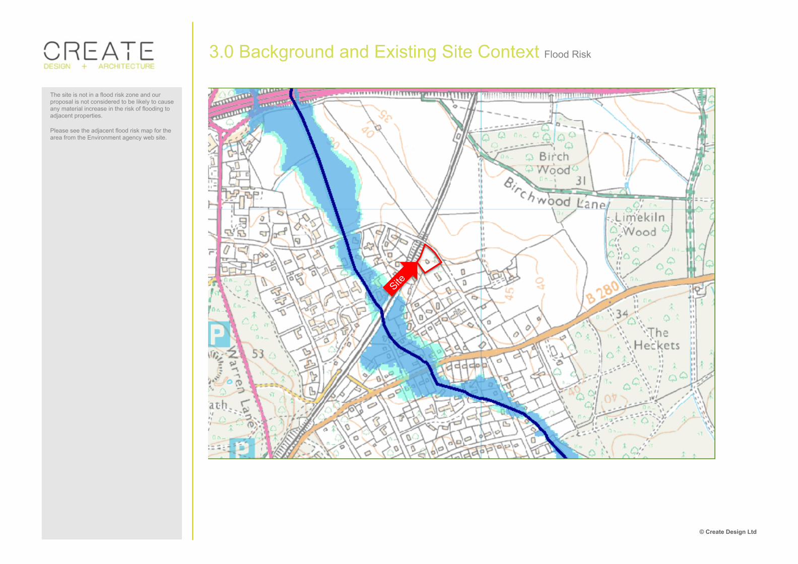
3.0 Background and Existing Site Context Flood Risk
The site is not in a flood risk zone and our proposal is not considered to be likely to cause any material increase in the risk of flooding to adjacent properties. Please see the adjacent flood risk map for the area from the Environment agency web site.

© Create Design Ltd
3.0 Background and Existing Site Context Planning Policy
The adjacent policy extracts are retained policies from the Elmbridge Borough Local Plan and are applicable to this site.
HSG16 PROPOSALS FOR RESIDENTIAL DEVELOPMENT AND REDEVELOPMENT, INCLUDING INFILL DEVELOPMENT AND EXTENSIONS, SHOULD BE SYMPATHETIC TO AND DO NOT DETRACT FROM THE APPEARANCE AND CHARACTER OF THE SURROUNDING AREAS. THEREFORE, PLANNING PERMISSION WILL BE GRANTED FOR PROPOSALS THAT:- (i) RESPECT THE INDIVIDUAL FEATURES OF THE SITE
INCLUDING LEVELS AND TOPOGRAPHY; (ii) ARE IN KEEPING WITH THE SCALE, PROPORTION,
LEVELS, AND LAYOUT OF BUILDINGS, ROADS, PARKING PROVISION AND OPEN SPACES IN THE AREA;
(iii) TAKE ACCOUNT OF THE RELATIONSHIP BETWEEN THE SIZE OF THE PROPOSED AND EXISTING BUILDINGS, THE PLOT SIZE AND THE PREVAILING DENSITY OF THE AREA;
(iv) TAKE ACCOUNT OF THE DISTANCE BETWEEN A PROPOSED DWELLING AND ITS SITE BOUNDARIES WHICH SHOULD BE CONSISTENT WITH OTHER BUILDINGS IN THE SURROUNDING AREA;
(v) TAKE ACCOUNT OF THE NEED FOR ADEQUATE SPACE BETWEEN THE PROPOSED NEW BUILDINGS AND THOSE BUILDINGS REMAINING, COMMENSURATE WITH THE SIZE OF BUILDINGS UNDER CONSIDERATION;
(vi) ARE IN KEEPING WITH THE VISUAL CHARACTERISTICS OF ANY IDENTIFIABLE STYLE, FORM OR DETAIL IN THE SURROUNDING AREA;
(vii) ENSURE THAT THE HEIGHT AND MASSING OF ITS VARIOUS ELEMENTS ARE NOT UNDULY PROMINENT IN RELATION TO THE SURROUNDING AREA;
(viii) AVOID A CRAMPED FORM OF DEVELOPMENT; (ix) AVOID OVERLOOKING AND AN UNREASONABLE
LOSS OF PRIVACY OR AMENITY; (x) ENSURE THAT THE USE OF MATERIALS AND
LANDSCAPING ARE APPROPRIATE TO THE SURROUNDING AREA; AND
(xi) ENSURE THAT THE SITING OF ANY NEW DEVELOPMENT, INCLUDING GARAGES, TAKES ACCOUNT OF THE EXISTING BUILDING LINE, WHERE DISTINCT, AND DOES NOT DOMINATE THE ROAD FRONTAGE
HSG17 IN THE SPECIAL LOW DENSITY RESIDENTIAL AREAS OF ST. GEORGE'S HILL ESTATE, BURWOOD PARK AND THE CROWN ESTATE, OXSHOTT, AS IDENTIFIED ON THE PROPOSALS MAP, IN ORDER TO PROTECT THEIR DISTINCTIVE VERY LOW DENSITY CHARACTERISTICS, MATURE LANDSCAPE SETTING AND COHESIVENESS OF THE ORIGINAL DESIGN CONCEPT, PROPOSALS FOR REDEVELOPMENT, INFILLING, EXTENSIONS AND ANCILLARY BUILDINGS WILL ONLY BE PERMITTED IF:- (i) THE RESULTING DWELLING PLOT/PLOTS ARE NO
SMALLER THAN THOSE PREVAILING IN THE SURROUNDING AREA;
(ii) THE RESULTING ROAD FRONTAGE OF THE PLOT/PLOTS IS OF A SIMILAR WIDTH TO THOSE ALREADY EXISTING IN THE SURROUNDING AREA, THE RESULTING DWELLING IS LOCATED CENTRALLY WITHIN THE PLOT FRONTAGE AND NEW PLOTS ARE NOT CONTRIVED IN SHAPE;
(iii) THE PROPOSALS ARE LIMITED TO A SIZE THAT DOES NOT DOMINATE THE PLOT, IN TERMS OF THE DISTANCE BETWEEN EXISTING AND PROPOSED DWELLINGS, MAKES ALLOWANCE FOR SUFFICIENT DISTANCES FROM ALL SITE BOUNDARIES TO RETAIN THE DEGREE OF SPACIOUSNESS AND IS NOT OUT OF SCALE WITH OTHER DWELLINGS PREDOMINANT IN THE SURROUNDING AREA;
(iv) NO PART OF A PROPOSED DWELLING, INCLUDING GARAGE, DOMINATES THE ROAD FRONTAGE OR ENCROACHES ON THE EXISTING BUILDING LINE, WHERE DISTINCT, OF THE SURROUNDING AREA; AND
(v) EXISTING LANDSCAPE FEATURES PARTICULARLY ON ALL SITE BOUNDARIES, WHICH MAKE A SIGNIFICANT CONTRIBUTION TO THE CHARACTER OF THE LOCALITY, ARE RETAINED WHERE APPROPRIATE.
IN THE CASE OF ST. GEORGE'S HILL ESTATE, AS IDENTIFIED ON THE PROPOSALS MAP, THE COUNCIL WILL NOT PERMIT ANY NEW SINGLE DWELLING PLOTS TO BE LESS THAN 0.4 HECTARE IN EXTENT, NOT INCLUDING ANY ROAD OR VERGE. ALL PROPOSALS SHOULD ALSO COMPLY WITH POLICIES HSG16 AND HSG18.

© Create Design Ltd
ENV2 IN ORDER TO PROTECT AND ENHANCE THE APPEARANCE OF THE AREA AND LOCAL AMENITY, ALL NEW DEVELOPMENT THROUGHOUT THE BOROUGH SHOULD ACHIEVE A STANDARD OF DESIGN WHICH IS SENSITIVE TO THE CHARACTER OF THE SURROUNDING AREA, AND WHICH: (i) RESPECTS ITS EXISTING CONTEXT IN TERMS OF
ESTABLISHED STREET PATTERNS, PLOT AND FRONTAGE SIZES, BUILDING ALIGNMENTS, VIEWS, LANDMARK BUILDINGS, NATURAL FEATURES AND THE SPACE ABOUT BUILDINGS;
(ii) RESPECTS THE SURROUNDING BUILT ENVIRONMENT IN TERMS OF THE SCALE, MASSING AND HEIGHT OF NEW BUILDINGS;
(iii) IN TERMS OF SITING, LAYOUT AND ACCESS ARRANGEMENTS, GIVES THE BUILT LAYOUT A CLEAR DEFINITION BETWEEN PUBLIC AND PRIVATE SPACE AND FORMS A CONVENIENT, ATTRACTIVE, LIVELY AND SAFE ENVIRONMENT FOR BOTH USERS OF THE DEVELOPMENT AND PASSERS-BY;
(iv) ACHIEVES A STRONG SENSE OF ENCLOSURE; AND (v) IN TERMS OF ITS FORM AND DESIGN, REINFORCES
EXISTING VISUAL CHARACTERISTICS AND IMPORTANT FEATURES.
ENV12 DEVELOPMENT WILL BE REFUSED IF IT WOULD RESULT IN THE LOSS OF TREES THAT ARE, OR ARE CAPABLE OF MAKING, A SIGNIFICANT CONTRIBUTION TO THE CHARACTER OR AMENITY OF THE AREA. WHERE PLANNING PERMISSION IS GRANTED, CONDITIONS MAY BE IMPOSED IN ORDER TO RETAIN THE MAXIMUM NUMBER OF TREES AND TO ENSURE THEIR PROTECTION DURING CONSTRUCTION. MOV4 ALL DEVELOPMENT PROPOSALS SHOULD MINIMISE THE IMPACT OF VEHICLE AND TRAFFIC NUISANCE, PARTICULARLY IN RESIDENTIAL AREAS AND, AS FAR AS PRACTICABLE, COMPLY WITH CURRENT HIGHWAY DESIGN STANDARDS. MOV6 PLANNING PERMISSION WILL NOT BE GRANTED FOR DEVELOPMENT PROPOSALS WHICH DO NOT ACCORD WITH THE ADOPTED MOTOR VEHICLE AND CYCLE PARKING STANDARDS UNLESS A REDUCTION IS MERITED BY THE PARTICULAR CIRCUMSTANCES OF THE CASE.
HSG19 THE COUNCIL, IN CONSIDERING PLANNING APPLICATIONS FOR ALL FORMS OF DEVELOPMENT, OR REDEVELOPMENT, WITHIN EXISTING RESIDENTIAL AREAS WILL ENSURE THAT BOTH GARAGING AND CAR PARKING ARE SO DESIGNED THAT THEY ARE INTEGRATED INTO THE SCHEME IN A SYMPATHETIC MANNER SO AS NOT TO DOMINATE THE RESIDENTIAL ENVIRONMENT. HSG20 THE COUNCIL WILL REQUIRE ALL EXTENSIONS AND ALTERATIONS TO EXISTING DWELLINGS TO COMPLY WITH THE FOLLOWING PRINCIPLES OF GOOD NEIGHBOURLINESS:- (i) A REASONABLE AMOUNT OF DAYLIGHT AND
SUNLIGHT SHOULD REACH THE HABITABLE ROOMS OF EACH DWELLING;
(ii) A REASONABLE DISTANCE BETWEEN ANY TWO-STOREY PART OF A DWELLING AND THE PLOT BOUNDARY SHOULD BE PROVIDED IN ORDER TO AVOID A TERRACING EFFECT ON DETACHED OR SEMI-DETACHED DWELLINGS;
(iii) A SUITABLE REAR GARDEN AMENITY SPACE WITH ADEQUATE SCREENING, WHERE APPROPRIATE OR NECESSARY, SHOULD BE PROVIDED;
(iv) REGARD WILL BE PAID TO THE RELATIONSHIP BETWEEN THE DEPTH OF A PROPOSED EXTENSION AND THE EDGE OF THE NEAREST NEIGHBOURING HABITABLE ROOM; AND
(v) AN ACCEPTABLE LEVEL OF PRIVACY TO HABITABLE ROOMS AND RECOGNISED SITTING OUT AREAS SHOULD BE MAINTAINED COMMENSURATE WITH THE PREVAILING CIRCUMSTANCES OF THE SURROUNDING AREA.
3.0 Background and Existing Site Context Planning Policy
Continued from previous page.

© Create Design Ltd
3.0 Background and Existing Site Context Planning History
There are several similar applications that have been made in the local area in recent history. Application 2001/2413 for Wilton House and Heathridge House (top left) was granted permission in 2001. This application sought permission to split an existing plot into two separate plots and to build two new houses. Application 2005/1511 for Warren Keep (top right) was granted in 2005 for the demolition of an existing building and the construction of a new two-storey house with accommodation in the roof space. Application 2005/1624 for Oak House and Bridestone (bottom left) was granted permission in 2005 to split and existing single plot into two separate sites with a new residential dwelling on each plot. Application 2006/2902 for Lone Oak (bottom right) was granted permission in 2006 to demolish an existing dwelling and build a new 1050sqm house. 2005/1511 – Warren Keep GRANTED
2005/1624 – Oak House and Bridestone GRANTED 2006/2902 – Lone Oak GRANTED
2001/2413 – Wilton House and Heathridge House GRANTED

© Create Design Ltd
4.0 Design Brief
The objective of the brief is to transform the existing Foxholes Site into two desirable family dwellings. Some of our main considerations during the design process were:
• Ensure that any proposal is sympathetic to its setting and enhances the character of the surrounding low density residential area.
• To provide dwellings that are more suitable for the size of
the site whilst providing new dwellings for this residential area.
• To provide external amenity space and parking for both
residential premises in accordance with the local plan and Surrey CC standards.
• To set the new houses back from Stokesheath Road so that
the resulting frontage of each plot is of a similar depth to those in the surrounding area.
• Retain existing landscape features and planting at site boundaries.

© Create Design Ltd
5.0 Use and Quantum Plot One
The site currently contains a single residential dwelling that we propose to demolish and replace with two new residential dwellings. Plot One is approx. 2493sqm and is proposed to contain a 660sqm single residential dwelling spread over 3 floors of accommodation with the top floor within the roof space. The Ground floor is for living space whilst the upper floors contain bedrooms and bathrooms. Plot One has a guest wing with accommodation over the garage. This space is connected to the rest of the house but is accessed via the ‘staff door’ at the side of the house. This is a 7 bedroom house.
Plot One Ground Floor Plan Plot One First Floor Plan
Plot One Second Floor Plan

© Create Design Ltd
5.0 Use and Quantum Plot Two
The site currently contains a single residential dwelling that we propose to demolish and replace with two new residential dwellings. Plot Two is approx. 2089sqm and the proposed house on this plot will be 584sqm. The layout of this house is similar to plot one except that this house does not have a separate guest wing. This is a 6 bedroom house.
Plot Two Ground Floor Plan Plot Two First Floor Plan
Plot Two Second Floor Plan

© Create Design Ltd
5.0 Use and Quantum Plot Density
Please see the adjacent plot density study. The footprint of each building(s) on site has been divided by the plot size to show a density ratio of building size to plot size. As you can see, our proposals for Foxholes are in keeping with the plot densities of the surrounding sites. The sites at ‘Wilton House and Heathridge House’ and ‘Oak House and Bridestone’ were both formerly single plots that have been developed. Our proposals for Foxholes have a lower plot density than both of these developments.
Foxholes Site 15.7% Proposed building coverage of site
Birchwood 12.0% Building coverage of site
Lone Oak 15.4% Building coverage of site
Wilton House and Heathridge House 16.7% Building coverage of site
Warren Keep 20.8% Building coverage of site
Oak House and Bridestone 16.7% Building coverage of site
N

© Create Design Ltd
6.0 Scale and Mass
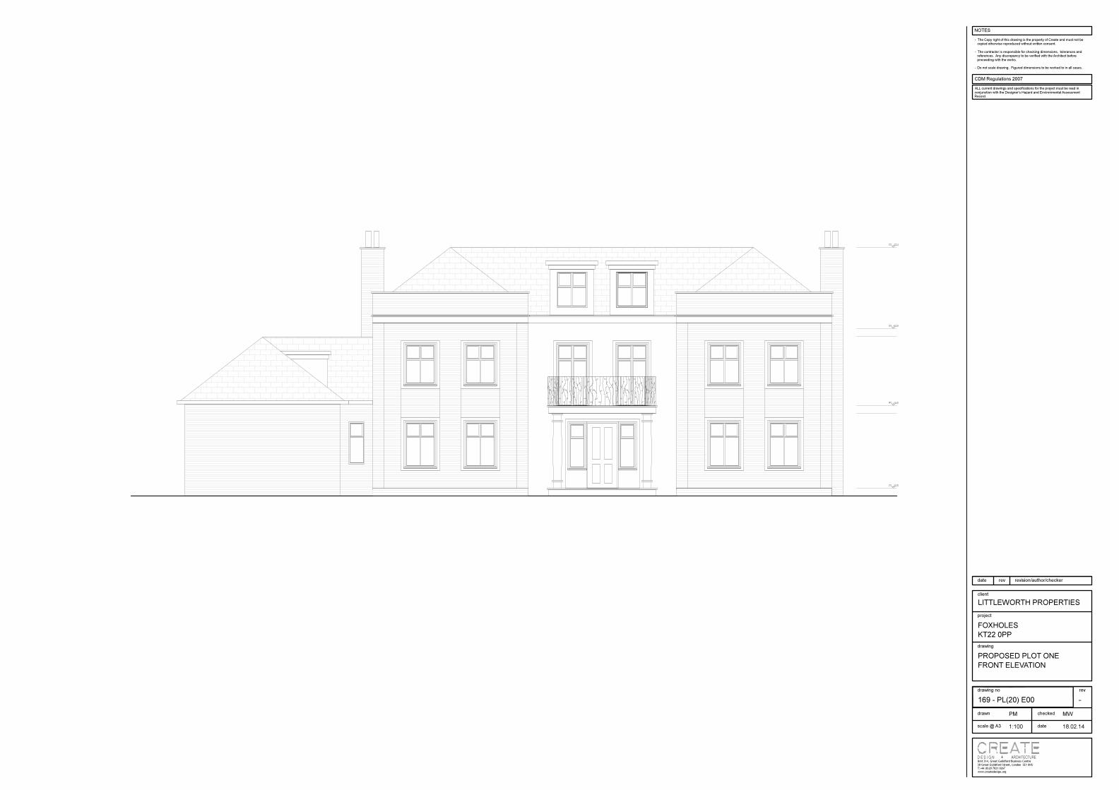
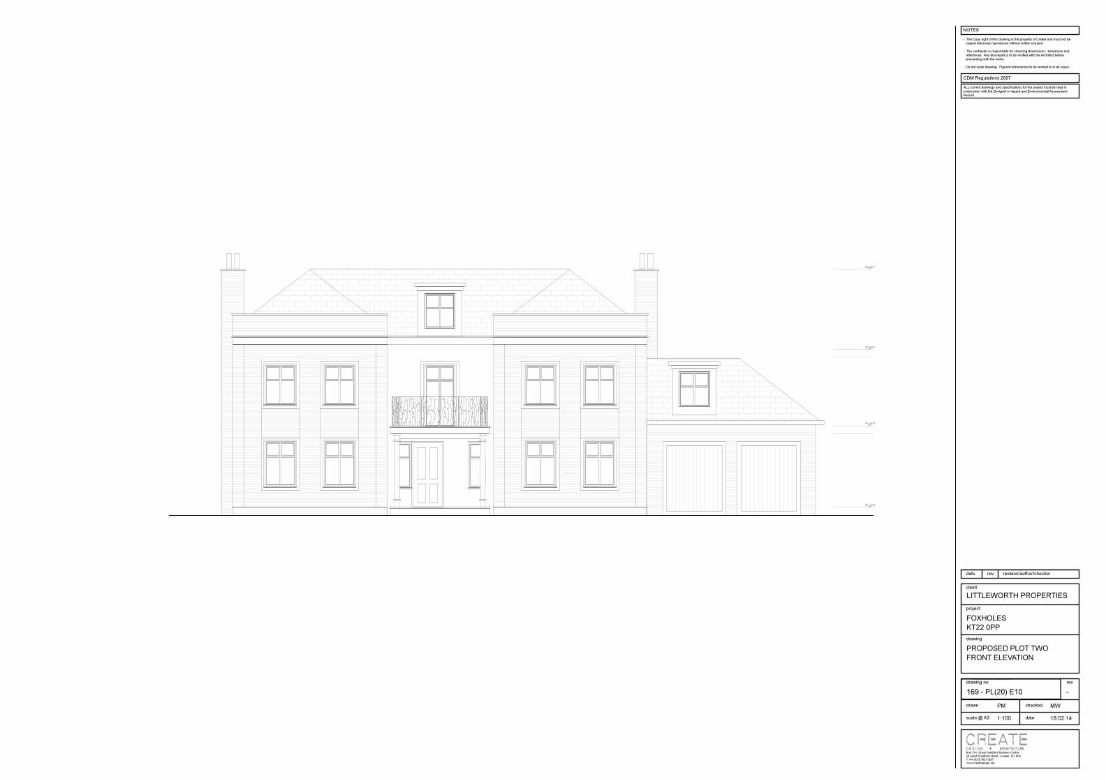
Plot One Front Elevation Plot Two Front Elevation
Plot One Rear Elevation Plot Two Rear Elevation
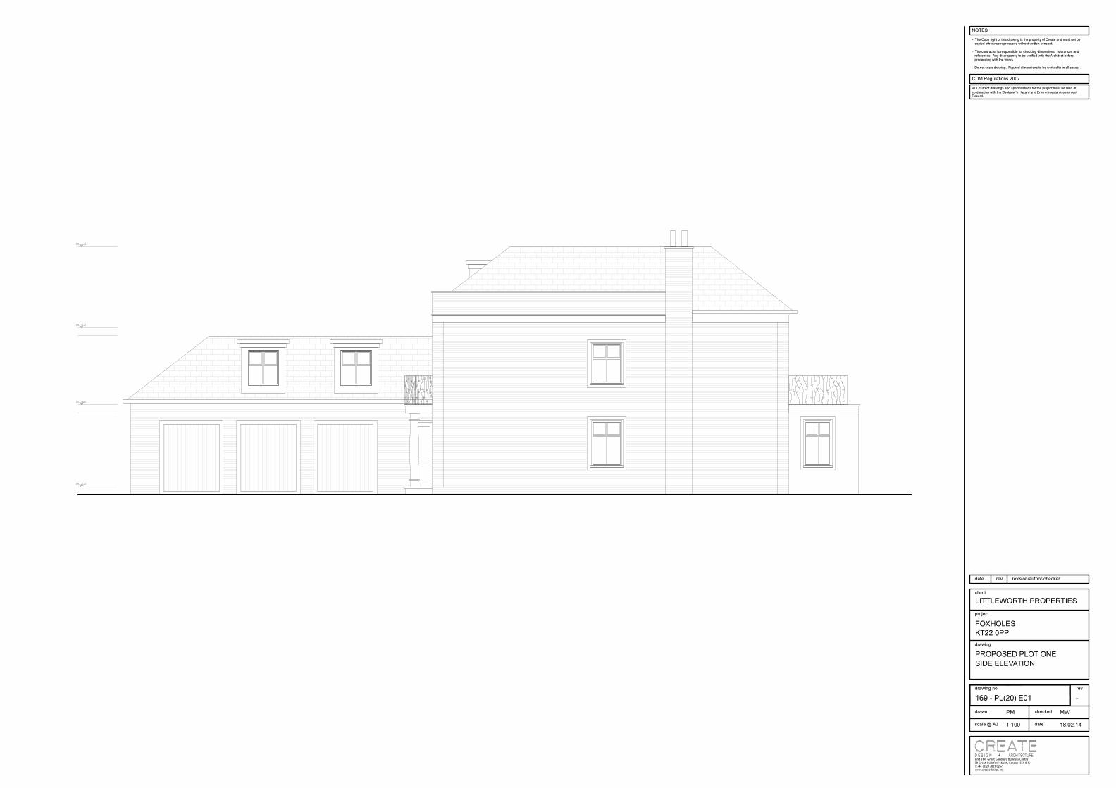
The proposed dwellings at Foxholes would in keeping with the style of the local area. The majority of the local buildings are brick with pitched roofs, however, there is no prevailing brick type or bond. There is precedent for buildings of similar size with attached garages and accommodation in the roof space. Both of our proposed buildings would have a ridge height of 9.34m.

© Create Design Ltd
7.0 Appearance and Materials
The appearance of the building(s) is in keeping with the local vernacular of large detached single family dwellings. This is a contemporary design that, like some of the surrounding houses, takes influence from Georgian style in its proportion and some detailed elements. The buildings would general be of masonry construction with buff brick facades. Some of the facades would be white render and certain details such as the window surrounds are also in white render. The building would have a slate roof, hidden behind a parapet on the front elevation and with a gutter at the rear. Dormer windows would be clad in lead.
White render and details Buff brick Slate roof and lead dormer
© Create Design Ltd
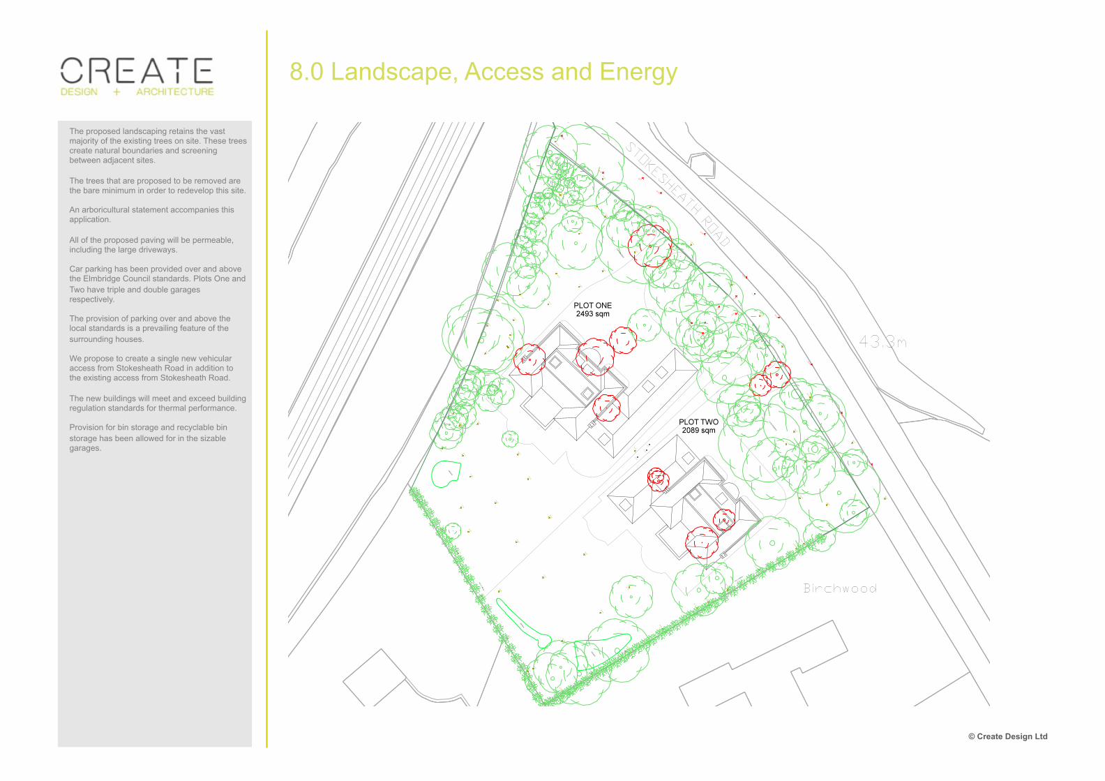
8.0 Landscape, Access and Energy
The proposed landscaping retains the vast majority of the existing trees on site. These trees create natural boundaries and screening between adjacent sites. The trees that are proposed to be removed are the bare minimum in order to redevelop this site. An arboricultural statement accompanies this application. All of the proposed paving will be permeable, including the large driveways. Car parking has been provided over and above the Elmbridge Council standards. Plots One and Two have triple and double garages respectively. The provision of parking over and above the local standards is a prevailing feature of the surrounding houses. We propose to create a single new vehicular access from Stokesheath Road in addition to the existing access from Stokesheath Road. The new buildings will meet and exceed building regulation standards for thermal performance. Provision for bin storage and recyclable bin storage has been allowed for in the sizable garages.

© Create Design Ltd
9.0 Concluding summary
We believe that our proposals for Foxholes are of a suitable size for the plot and are in keeping with the local vernacular of large single family dwellings. With respect to special policy HSG17 which refers to the area of Oxshott in particular, we believe that our proposals fulfil all of the requires to permit development. The plot sizes resulting from the division of the existing plot is no smaller than those prevailing in the surrounding area. The resulting road frontage of the plots are of a similar width to those existing in the surrounding area and the resulting dwellings are located centrally within the plot. The proposed houses would not dominate the plots and are not out of scale with other dwellings predominant in the local area. No part of either dwelling is considered to dominate the road frontage and the existing landscape features have generally been retained. We therefore believe that this proposal is in line with Elmbridge council planning policy.


MSL9505-T
1:100@A0
Topographic Survey
The user or recipient of this survey data understands and acknowledgesthis data may be inaccurate or contain errors or omissions and the useror recipient assumes full responsibility for any risks or damages resultingfrom, arising from, or in connection with any use of or reliance upon datadisplayed herein. Although significant care has been exercised toproduce surveys that satisfy survey accuracy standards, these surveysare only as accurate as the source data from which they were compiled.Although all reasonable steps have been taken to locate all featuresvisible at the time of the survey, there is no guarantee that all will beshown on the drawing, as some above ground features may haveobstructed the survey. Wherever possible, areas unable to be surveyedwill be labelled as “UTS”. The Company shall not be liable for any inaccuracy of the data providedbeyond the specified scale or accuracy, or for any matters resulting fromtheir use for purposes other than that stated in the Contract. No liabilityshall attach to the Surveyor in respect of any consequential loss ordamages suffered by the Client.The Client must promptly notify the Company of any errors in mapping ofwhich it becomes aware. If misleading, inaccurate or otherwiseinappropriate information is brought to the Company's attention or theCompany itself identifies any such imprecision or error in a survey, it shalluse its reasonable endeavours to fix or remove it and if necessary incertain instances, the Company being on notice of any such misleading,inaccurate or otherwise inappropriate information, it will re-conduct thesurvey and reproduce the data to within the specified scale or accuracy.
Murphy Surveys Ltd. Disclaimer
Phone: (+44) 020 3178 6644Email:[email protected]
T
No. 318
London Glasgow Belfast Cork Kildare
Topographic surveys, Measured Building Surveys, Setting-Out, As-Built Surveys, Hydrographic Surveys, Legal Mapping,
Pipeline Surveys, Services Location, Ground Penetrating Radar,Laser Scanning, Rectified Photography
c Copyright 2014 MURPHY SURVEYS LTD
UK Head Office9 Devonshire SquareLondonEC2M 4YF
Map Sheet Layout:
No. Date Description
Revisions
Surveyed by :Drawn by :
Date:Date:
Checked by : Date:
A First Issue22/04/2014
15/04/201422/04/201422/04/2014
KSKSTMD
Datum :Grid System:
Arbitrary
Drawing Number :
Client :
Scale :Date :
Project :
Description :
22/04/2014
Create Design
Foxholes
Arbitrary
www.murphysurveys.co.uk
Street Furniture & Services
Built FeaturesRoads & Road Markings
Natural Features
Golf
LEGEND
5.12WLVL
WM
Water Level
Water Main
TRFCAB
VE
Treeline
Traffic Cabinet
Valve
Wall
5.12
TP
Top of Wall Level
Telegraph Pole
Tree Coniferous
Tree Deciduous
SV
5.12SWMH
TBOX
TL
5.12TOP
5.12TOT
Stop Valve
Surface Water MH
Tee Box
Traffic Light
Top of Pipe
Top of Tree
STAY
S11000.0001000.000100.00
5.12STPL
5.12STRM
Stay for pole
Survey Station
Step Level
Stream
Surface Change
SIGN
5.12
5.12
SOFF
Sign
Bottom of Slope
Top of Slope
Underside of Soffit
SC
SCRUB
5.12
Stop Cock
Scrub
Natural Surface
5.12POND
5.12
5.12
5.12
RS
Pond Line
Railway
River
Edge of Road
Road Sign
PARAPET
PBOX
POLE
Parapet Height
Phone Box
Pole
5.12MHCL
5.12MHSQ
5.12
Circular Manhole
Manhole Square
Hard Surface
Over Head Wires
5.12
IL
5.12
5.12
5.12LAKE
LD
LS
Invert Level
Kerb (bottom)
Kerb, (top)
Lake Line
Land Drain
Lamp StandIC
ICCICEICT
Inspection Cover
(Cable TV)(Electricity)(Telecoms)
GATE
GREE
GY
H Gate
Green
Gully
Fire Hydrant
Hedge Line
FL
FMH
FOPTIC
5.12
FWAY
GAS
5.12
Floor Level
Foul Manhole
Fiber Optic
Footpath
Fair Way
Gas Valve
EAVES
EP
EBOX
Eaves Height
Electricity Pole
Electricity Cabinet
Line of Fence
DUCT Duct
CONCB
Bush
Concrete Base
B
BIN
Bollard
Waste Bin
Building
Bus Shelter
AV Air Valve
APEX
ARMCO
Apex Height
Crash Barrier
Contour lines
Overgrowth
5.12
50.02
BH 3.67
DH 2.22
F-C 0.27C-H 3.34
Beam Height
Door HeightFloor to CillCill to Head
Ceiling Height
Floor Level
4.37
False Ceiling Height2.33F
Height
Air Conditioner
Arrows Point Up
Sloping Ceiling
h 0.9
A/C
Fire DoorFD
Internal SurveyFeatures
Site Location

North
MSL9505-E-01
1:50@A1
External Elevation 1 & 2
The user or recipient of this survey data understands and acknowledgesthis data may be inaccurate or contain errors or omissions and the user orrecipient assumes full responsibility for any risks or damages resultingfrom, arising from, or in connection with any use of or reliance upon datadisplayed herein. Although significant care has been exercised toproduce surveys that satisfy survey accuracy standards, these surveys areonly as accurate as the source data from which they were compiled.Although all reasonable steps have been taken to locate all features visibleat the time of the survey, there is no guarantee that all will be shown on thedrawing, as some above ground features may have obstructed the survey.Wherever possible, areas unable to be surveyed will be labelled as “UTS”. The Company shall not be liable for any inaccuracy of the data providedbeyond the specified scale or accuracy, or for any matters resulting fromtheir use for purposes other than that stated in the Contract. No liabilityshall attach to the Surveyor in respect of any consequential loss ordamages suffered by the Client.The Client must promptly notify the Company of any errors in mapping ofwhich it becomes aware. If misleading, inaccurate or otherwiseinappropriate information is brought to the Company's attention or theCompany itself identifies any such imprecision or error in a survey, it shalluse its reasonable endeavours to fix or remove it and if necessary incertain instances, the Company being on notice of any such misleading,inaccurate or otherwise inappropriate information, it will re-conduct thesurvey and reproduce the data to within the specified scale or accuracy.
Murphy Surveys Ltd. Disclaimer
Phone: (+44) 020 3178 6644Email:[email protected]
T
No. 318
London Glasgow Belfast Cork Kildare
Topographic surveys, Measured Building Surveys, Setting-Out, As-Built Surveys, Hydrographic Surveys, Legal Mapping,
Pipeline Surveys, Services Location, Ground Penetrating Radar,Laser Scanning, Rectified Photography
c Copyright 2014 MURPHY SURVEYS LTD
UK Head Office9 Devonshire SquareLondonEC2M 4YF
Map Sheet Layout:
No. Date Description
Revisions
Surveyed by :Drawn by :
Date:Date:
Checked by : Date:
A PROVISIONAL ISSUE17/04/2014
15/04/201417/04/201417/04/2014
KSAGTMD
Datum :Grid System:
Arbitrary
Drawing Number :
Client :
Scale :Date :
Project :
Description :
17/04/2014
Create Design
Foxholes
Arbitrary
www.murphysurveys.co.uk
Site Location
Tree Coniferous
Tree Deciduous
Water HeaterVPWH
VVent PipeVent
SL Skylight
Site Bench MarkSpring Height
Rolled Steel JoistRain Water Pipe
RSJ
SBM SH
RWP
Beam Soffit LevelBSL
A/CAH
Air Conditioner
Break Glass PointBeam Height
Arch Height
Arch Spring Height
B Bollard
BHBGP
ASH Arch Spring LevelASL
Arch LevelAL
Cill to Head HeightC-H
Fire HydrantFire Hose Reel
Fire ExtinguisherFire Alarm
Floodlight
FHR
Flt
FEFH
FA
CupboardDoor Height
Electrical SwitchgearDrainage ChannelDrC
ESG
DHCup
ConcreteConc
Floor to Cill HeightF-C
Inspection CoverIC
h heightHandrailHR
Recessed Door Mat
Ordnance Survey Bench Mark
RDM Rad RadiatorOSBM O/H Overhead
L LightMax MaximumMin Minimum
Down PipeDP
20.00 Floor Level
7.78 Ceiling Height
2.76F False Ceiling Height
Arrows point up unless on roofsCeiling Slope
Arched Ceiling
Door
Wardrobe Door
Sliding Door
Sink / Bath
Toilets
Showers
Roof Access
Window
Sash WindowRadiators
Built FeaturesRoads & Road Markings
LEGEND
Wall
5.12 Top of Wall Level
S11000.0001000.000100.00
5.12STPL
Survey Station
Step Level
Surface Change
SOFF Underside of Soffit
5.12
5.12
Railway
Edge of Road
PARAPET Parapet Height
5.12 Hard Surface
5.12
5.12
LD
Kerb (bottom)
Kerb, (top)
Land Drain
FL
5.12
Floor Level
Footpath EAVES Eaves Height
Line of Fence
CONCB Concrete Base
Building
ARMCO Crash Barrier
5.12
BH 3.67
DH 2.22
F-C 0.27C-H 3.34
Beam Height
Door HeightFloor to CillCill to Head
Heighth 0.9
Fire DoorFD
Internal SurveyFeatures
Description of Features
Elevation 1
Elevation 3
Ele
vatio
n 2
Elevation 4
PROVISIONAL ISSUE

North
MSL9505-E-02
1:50@A1
External Elevation 3 & 4
The user or recipient of this survey data understands and acknowledgesthis data may be inaccurate or contain errors or omissions and the user orrecipient assumes full responsibility for any risks or damages resultingfrom, arising from, or in connection with any use of or reliance upon datadisplayed herein. Although significant care has been exercised toproduce surveys that satisfy survey accuracy standards, these surveys areonly as accurate as the source data from which they were compiled.Although all reasonable steps have been taken to locate all features visibleat the time of the survey, there is no guarantee that all will be shown on thedrawing, as some above ground features may have obstructed the survey.Wherever possible, areas unable to be surveyed will be labelled as “UTS”. The Company shall not be liable for any inaccuracy of the data providedbeyond the specified scale or accuracy, or for any matters resulting fromtheir use for purposes other than that stated in the Contract. No liabilityshall attach to the Surveyor in respect of any consequential loss ordamages suffered by the Client.The Client must promptly notify the Company of any errors in mapping ofwhich it becomes aware. If misleading, inaccurate or otherwiseinappropriate information is brought to the Company's attention or theCompany itself identifies any such imprecision or error in a survey, it shalluse its reasonable endeavours to fix or remove it and if necessary incertain instances, the Company being on notice of any such misleading,inaccurate or otherwise inappropriate information, it will re-conduct thesurvey and reproduce the data to within the specified scale or accuracy.
Murphy Surveys Ltd. Disclaimer
Phone: (+44) 020 3178 6644Email:[email protected]
T
No. 318
London Glasgow Belfast Cork Kildare
Topographic surveys, Measured Building Surveys, Setting-Out, As-Built Surveys, Hydrographic Surveys, Legal Mapping,
Pipeline Surveys, Services Location, Ground Penetrating Radar,Laser Scanning, Rectified Photography
c Copyright 2014 MURPHY SURVEYS LTD
UK Head Office9 Devonshire SquareLondonEC2M 4YF
Map Sheet Layout:
No. Date Description
Revisions
Surveyed by :Drawn by :
Date:Date:
Checked by : Date:
A PROVISIONAL ISSUE17/04/2014
15/04/201417/04/201417/04/2014
KSAGTMD
Datum :Grid System:
Arbitrary
Drawing Number :
Client :
Scale :Date :
Project :
Description :
17/04/2014
Create Design
Foxholes
Arbitrary
www.murphysurveys.co.uk
Site Location
Tree Coniferous
Tree Deciduous
Water HeaterVPWH
VVent PipeVent
SL Skylight
Site Bench MarkSpring Height
Rolled Steel JoistRain Water Pipe
RSJ
SBM SH
RWP
Beam Soffit LevelBSL
A/CAH
Air Conditioner
Break Glass PointBeam Height
Arch Height
Arch Spring Height
B Bollard
BHBGP
ASH Arch Spring LevelASL
Arch LevelAL
Cill to Head HeightC-H
Fire HydrantFire Hose Reel
Fire ExtinguisherFire Alarm
Floodlight
FHR
Flt
FEFH
FA
CupboardDoor Height
Electrical SwitchgearDrainage ChannelDrC
ESG
DHCup
ConcreteConc
Floor to Cill HeightF-C
Inspection CoverIC
h heightHandrailHR
Recessed Door Mat
Ordnance Survey Bench Mark
RDM Rad RadiatorOSBM O/H Overhead
L LightMax MaximumMin Minimum
Down PipeDP
20.00 Floor Level
7.78 Ceiling Height
2.76F False Ceiling Height
Arrows point up unless on roofsCeiling Slope
Arched Ceiling
Door
Wardrobe Door
Sliding Door
Sink / Bath
Toilets
Showers
Roof Access
Window
Sash WindowRadiators
Built FeaturesRoads & Road Markings
LEGEND
Wall
5.12 Top of Wall Level
S11000.0001000.000100.00
5.12STPL
Survey Station
Step Level
Surface Change
SOFF Underside of Soffit
5.12
5.12
Railway
Edge of Road
PARAPET Parapet Height
5.12 Hard Surface
5.12
5.12
LD
Kerb (bottom)
Kerb, (top)
Land Drain
FL
5.12
Floor Level
Footpath EAVES Eaves Height
Line of Fence
CONCB Concrete Base
Building
ARMCO Crash Barrier
5.12
BH 3.67
DH 2.22
F-C 0.27C-H 3.34
Beam Height
Door HeightFloor to CillCill to Head
Heighth 0.9
Fire DoorFD
Internal SurveyFeatures
Description of Features
Elevation 1
Elevation 3
Ele
vatio
n 2
Elevation 4
PROVISIONAL ISSUE

North
MSL9505-FP1
1:50@A1
Floor Plan - First Floor
The user or recipient of this survey data understands and acknowledgesthis data may be inaccurate or contain errors or omissions and the user orrecipient assumes full responsibility for any risks or damages resultingfrom, arising from, or in connection with any use of or reliance upon datadisplayed herein. Although significant care has been exercised toproduce surveys that satisfy survey accuracy standards, these surveys areonly as accurate as the source data from which they were compiled.Although all reasonable steps have been taken to locate all features visibleat the time of the survey, there is no guarantee that all will be shown on thedrawing, as some above ground features may have obstructed the survey.Wherever possible, areas unable to be surveyed will be labelled as “UTS”. The Company shall not be liable for any inaccuracy of the data providedbeyond the specified scale or accuracy, or for any matters resulting fromtheir use for purposes other than that stated in the Contract. No liabilityshall attach to the Surveyor in respect of any consequential loss ordamages suffered by the Client.The Client must promptly notify the Company of any errors in mapping ofwhich it becomes aware. If misleading, inaccurate or otherwiseinappropriate information is brought to the Company's attention or theCompany itself identifies any such imprecision or error in a survey, it shalluse its reasonable endeavours to fix or remove it and if necessary incertain instances, the Company being on notice of any such misleading,inaccurate or otherwise inappropriate information, it will re-conduct thesurvey and reproduce the data to within the specified scale or accuracy.
Murphy Surveys Ltd. Disclaimer
Phone: (+44) 020 3178 6644Email:[email protected]
T
No. 318
London Glasgow Belfast Cork Kildare
Topographic surveys, Measured Building Surveys, Setting-Out, As-Built Surveys, Hydrographic Surveys, Legal Mapping,
Pipeline Surveys, Services Location, Ground Penetrating Radar,Laser Scanning, Rectified Photography
c Copyright 2014 MURPHY SURVEYS LTD
UK Head Office9 Devonshire SquareLondonEC2M 4YF
Map Sheet Layout:
No. Date Description
Revisions
Surveyed by :Drawn by :
Date:Date:
Checked by : Date:
A PROVISIONAL ISSUE17/04/2014
15/04/201417/04/201417/04/2014
KSAGTMD
Datum :Grid System:
Arbitrary
Drawing Number :
Client :
Scale :Date :
Project :
Description :
17/04/2014
Create Design
Foxholes
Arbitrary
www.murphysurveys.co.uk
Site Location
Tree Coniferous
Tree Deciduous
Water HeaterVPWH
VVent PipeVent
SL Skylight
Site Bench MarkSpring Height
Rolled Steel JoistRain Water Pipe
RSJ
SBM SH
RWP
Beam Soffit LevelBSL
A/CAH
Air Conditioner
Break Glass PointBeam Height
Arch Height
Arch Spring Height
B Bollard
BHBGP
ASH Arch Spring LevelASL
Arch LevelAL
Cill to Head HeightC-H
Fire HydrantFire Hose Reel
Fire ExtinguisherFire Alarm
Floodlight
FHR
Flt
FEFH
FA
CupboardDoor Height
Electrical SwitchgearDrainage ChannelDrC
ESG
DHCup
ConcreteConc
Floor to Cill HeightF-C
Inspection CoverIC
h heightHandrailHR
Recessed Door Mat
Ordnance Survey Bench Mark
RDM Rad RadiatorOSBM O/H Overhead
L LightMax MaximumMin Minimum
Down PipeDP
20.00 Floor Level
7.78 Ceiling Height
2.76F False Ceiling Height
Arrows point up unless on roofsCeiling Slope
Arched Ceiling
Door
Wardrobe Door
Sliding Door
Sink / Bath
Toilets
Showers
Roof Access
Window
Sash WindowRadiators
Built FeaturesRoads & Road Markings
LEGEND
Wall
5.12 Top of Wall Level
S11000.0001000.000100.00
5.12STPL
Survey Station
Step Level
Surface Change
SOFF Underside of Soffit
5.12
5.12
Railway
Edge of Road
PARAPET Parapet Height
5.12 Hard Surface
5.12
5.12
LD
Kerb (bottom)
Kerb, (top)
Land Drain
FL
5.12
Floor Level
Footpath EAVES Eaves Height
Line of Fence
CONCB Concrete Base
Building
ARMCO Crash Barrier
5.12
BH 3.67
DH 2.22
F-C 0.27C-H 3.34
Beam Height
Door HeightFloor to CillCill to Head
Heighth 0.9
Fire DoorFD
Internal SurveyFeatures
Description of Features
PROVISIONAL ISSUE

North
MSL9505-FPG
1:50@A1
Floor Plan - Ground Floor
The user or recipient of this survey data understands and acknowledgesthis data may be inaccurate or contain errors or omissions and the user orrecipient assumes full responsibility for any risks or damages resultingfrom, arising from, or in connection with any use of or reliance upon datadisplayed herein. Although significant care has been exercised toproduce surveys that satisfy survey accuracy standards, these surveys areonly as accurate as the source data from which they were compiled.Although all reasonable steps have been taken to locate all features visibleat the time of the survey, there is no guarantee that all will be shown on thedrawing, as some above ground features may have obstructed the survey.Wherever possible, areas unable to be surveyed will be labelled as “UTS”. The Company shall not be liable for any inaccuracy of the data providedbeyond the specified scale or accuracy, or for any matters resulting fromtheir use for purposes other than that stated in the Contract. No liabilityshall attach to the Surveyor in respect of any consequential loss ordamages suffered by the Client.The Client must promptly notify the Company of any errors in mapping ofwhich it becomes aware. If misleading, inaccurate or otherwiseinappropriate information is brought to the Company's attention or theCompany itself identifies any such imprecision or error in a survey, it shalluse its reasonable endeavours to fix or remove it and if necessary incertain instances, the Company being on notice of any such misleading,inaccurate or otherwise inappropriate information, it will re-conduct thesurvey and reproduce the data to within the specified scale or accuracy.
Murphy Surveys Ltd. Disclaimer
Phone: (+44) 020 3178 6644Email:[email protected]
T
No. 318
London Glasgow Belfast Cork Kildare
Topographic surveys, Measured Building Surveys, Setting-Out, As-Built Surveys, Hydrographic Surveys, Legal Mapping,
Pipeline Surveys, Services Location, Ground Penetrating Radar,Laser Scanning, Rectified Photography
c Copyright 2014 MURPHY SURVEYS LTD
UK Head Office9 Devonshire SquareLondonEC2M 4YF
Map Sheet Layout:
No. Date Description
Revisions
Surveyed by :Drawn by :
Date:Date:
Checked by : Date:
A PROVISIONAL ISSUE17/04/2014
15/04/201417/04/201417/04/2014
KSAGTMD
Datum :Grid System:
Arbitrary
Drawing Number :
Client :
Scale :Date :
Project :
Description :
17/04/2014
Create Design
Foxholes
Arbitrary
www.murphysurveys.co.uk
Site Location
Tree Coniferous
Tree Deciduous
Water HeaterVPWH
VVent PipeVent
SL Skylight
Site Bench MarkSpring Height
Rolled Steel JoistRain Water Pipe
RSJ
SBM SH
RWP
Beam Soffit LevelBSL
A/CAH
Air Conditioner
Break Glass PointBeam Height
Arch Height
Arch Spring Height
B Bollard
BHBGP
ASH Arch Spring LevelASL
Arch LevelAL
Cill to Head HeightC-H
Fire HydrantFire Hose Reel
Fire ExtinguisherFire Alarm
Floodlight
FHR
Flt
FEFH
FA
CupboardDoor Height
Electrical SwitchgearDrainage ChannelDrC
ESG
DHCup
ConcreteConc
Floor to Cill HeightF-C
Inspection CoverIC
h heightHandrailHR
Recessed Door Mat
Ordnance Survey Bench Mark
RDM Rad RadiatorOSBM O/H Overhead
L LightMax MaximumMin Minimum
Down PipeDP
20.00 Floor Level
7.78 Ceiling Height
2.76F False Ceiling Height
Arrows point up unless on roofsCeiling Slope
Arched Ceiling
Door
Wardrobe Door
Sliding Door
Sink / Bath
Toilets
Showers
Roof Access
Window
Sash WindowRadiators
Built FeaturesRoads & Road Markings
LEGEND
Wall
5.12 Top of Wall Level
S11000.0001000.000100.00
5.12STPL
Survey Station
Step Level
Surface Change
SOFF Underside of Soffit
5.12
5.12
Railway
Edge of Road
PARAPET Parapet Height
5.12 Hard Surface
5.12
5.12
LD
Kerb (bottom)
Kerb, (top)
Land Drain
FL
5.12
Floor Level
Footpath EAVES Eaves Height
Line of Fence
CONCB Concrete Base
Building
ARMCO Crash Barrier
5.12
BH 3.67
DH 2.22
F-C 0.27C-H 3.34
Beam Height
Door HeightFloor to CillCill to Head
Heighth 0.9
Fire DoorFD
Internal SurveyFeatures
Description of Features
PROVISIONAL ISSUE