Embed Size (px)
Citation preview
Linn CountyLivingston County
Linn CountyChariton County
Livingsto
n County
Charito
n County
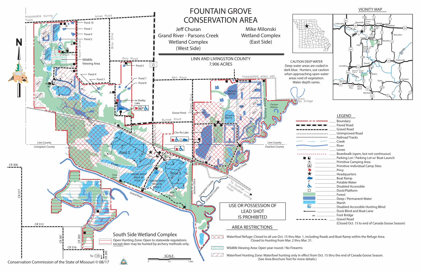
Conservation Commission of the State of Missouri © 08/17
PumpHouse
Grand River
Locust Creek
Jack
son
Ditc
h
65
CR 306
CR 3
77
CR 312
CR 3
81
CR 3
83
CR 316
CR 3
85
Pool 1
Pool 2
Pool 3
CAUTION DEEP WATERDeep water areas are coded in
dark blue. Hunters, use cautionwhen approaching open water
areas void of vegetation.Water depth varies.
USE OR POSSESSION OFLEAD SHOT
IS PROHIBITED
FOUNTAIN GROVECONSERVATION AREA
LINN AND LIVINGSTON COUNTY7,906 ACRES
Je� ChuranGrand River - Parsons Creek
Wetland Complex(West Side)
Mike MilonskiWetland Complex
(East Side)
WildlifeViewing Area
Waterfowl Refuge: Closed to all use Oct. 15 thru Mar. 1, including Roads and Boat Ramp within the Refuge Area. Closed to Hunting from Mar. 2 thru Mar. 31.
Wildlife Viewing Area: Open year-round / No Firearms
Waterfowl Hunting Zone: Waterfowl hunting only in e�ect from Oct. 15 thru the end of Canada Goose Season. (See Area Brochure Text for more details.)
BoundaryPaved RoadGravel RoadUnimproved RoadRailroad TracksCreekRiverLeveeBoardwalk (open, but not continuous)Parking Lot / Parking Lot w/ Boat LaunchPrimitive Camping AreaPrimitive-Individual Camp SitesPrivyHeadquartersBoat RampPotable WaterDisabled AccessibleDock/PlatformForestDeep / Permanent WaterMarshDisabled Accessible Hunting BlindDuck Blind and Boat LaneFoot BridgeGravel Road(Closed Oct. 15 to end of Canada Goose Season)
Pond 10
Pond 9
Pond 1
Pond 2
Pond 3
Pond 4
Pond 5
Pond 7
Pond 8
Goose Pond
Che-Ru Lake
Jo ShelbyLake
AREA RESTRICTIONS
0 1/2 1 Mile
SCALE
VICINITY MAP
LEGEND
3636
65
65
65
65
24
24
24
Marceline
Brook�eldLacledeMeadvilleChillicothe
Hale
Sumner
GlasgowSlater
Miami
Marshall
MaltaBend
GrandPass
Waverly
CarrolltonDewitt
Mendon
Keytesville
To 139
South Side Wetland ComplexOpen Hunting Zone: Open to statewide regulationsexcept deer may be hunted by archery methods only.
West
Emerson
East
Emerson
N
orth
Parsons
West
Parsons
Mac 1
Mac 2
Mac 3 Mac 4
Mac 5
E LANE
GRAND RIVERWALK-INPOOL 2 GRAND RIVER
WALK-INPOOL 3
ASHPOOL
J1J2
J3
H1
H2
G12
G10G7
G9
G8
G5
G3
G4
G2E3 G1
A1
A2B1
B3
B6C1
C2B8
A4
J4