Embed Size (px)
Citation preview

4/11
FORM H PARKS AND LANDSCAPES
MASSACHUSETTS HISTORICAL COMMISSION
MASSACHUSETTS ARCHIVES BUILDING
220 MORRISSEY BOULEVARD
BOSTON, MASSACHUSETTS 02125
Photograph
Photo 1. View from southern end of the park, looking north to Woodbury Point; Lothrop Street to the left.
Locus Map (north at top)
Assessor’s USGS Area(s) Form No. Forms within Number Map
5-462 Salem BEV.957 BEV.981 - 983
Town/City: Beverly
Place: Downtown
Address or Location: 41 Lothrop Street (Note: 35 Lothrop Street address on 1970 Form H is incorrect)
Name: Independence Park
Ownership: Public Private
Type of Landscape (check one): _x park ___ green/common ___ garden ___ boulevard/parkway
___ farm land ___ mine/quarry ___ training field
___other (specify):
Date or Period: 1775; 1906; 1978
Source: Charles Woodberry ms. 1906 Beverly Historical Society
Landscape Architect: n/a
Location of Plans: n/a
Alterations/Intrusions (with dates): none
Condition: Good
Acreage: 2.85 acres
Setting: Located on Beverly Harbor shoreline surrounded by a residential neighborhood of large, predominantly late 19th and early 20th century houses.
Recorded by: Pamela Hartford and Wendy Frontiero
Organization: Beverly Historic District Commission
Date: September 2016
Follow Massachusetts Historical Commission Survey Manual instructions for completing this form.

INVENTORY FORM H CONTINUATION SHEET BEVERLY 41 LOTHROP STREET
MASSACHUSETTS HISTORICAL COMMISSION Area(s) Form No.
220 MORRISSEY BOULEVARD, BOSTON, MASSACHUSETTS 02125
Recommended for listing in the National Register of Historic Places. If checked, you must attach a completed National Register Criteria Statement form.
VISUAL/DESIGN ASSESSMENT
Independence Park occupies a narrow, quarter-mile stretch of land that faces directly onto Beverly Harbor and the Atlantic Ocean. Its naturally-formed beach is part of a long curve of shallow coastline created by deposits from the Danvers River collecting between Tuck’s Point and Woodbury Point to the north. The recessed shallow waters between these points is known as Mackerel Cove.
Independence Park is situated toward the south end of Mackerel Cove, bordered on its southern end by Wilson Street and on the west by Lothrop Street. Large, late nineteenth century houses on ample lots face the Park across Lothrop Street; behind them lies a gridded neighborhood of one-way streets, with mid to late nineteenth and early twentieth century houses on small lots. From the Park, one can see along the curve of Mackerel Cove to Woodbury Point on the northeast (Photo 1) and across Beverly Harbor to Salem Neck and into Salem Harbor to the south. The land slopes steeply down twenty feet from the sidewalk at Lothrop Street to a fieldstone retaining wall that separates the turf surface of the Park from the beach.
The southern end of the park follows the grade of Wilson Street to the water’s edge, where it meets a stone breakwater. (Photo 2). At the center of the Park, a set of eight concrete steps with formed concrete posts and caps creates a formal entry from the sidewalk. (Photo 3) A concrete path from these steps leads to a large granite Boulder inset with a Revolutionary War Commemorative Plaque (1929). The boulder is framed by a shrub border with a pair of yews and rosa rugosa, three newly planted weeping cherry trees, and two willow trees. (Photo 4) The inscription on the bronze Plaque (Photo 5) reads:
INDEPENDENCE PARKNEAR THIS SPOT JULY 17, 1776 AT 6 PMTHE DECLARATION OF INDEPENDENCE
WAS READ BY COL JOHN GLOVERTO THE 14TH CONTINENTAL REGIMENT INCLUDING
CAPT MOSES BROWN’S BEVERLY COMPANYSTATIONED HERE TO PROTECT THE TOWN,
MILITARY STORES AND PRIZE SHIPS,THE FIRST ARMY POST NORTH OF THE ENVIRONS OF BOSTON
IN THESE WATERS, SEPT 5, 1775 AT 10:00 AMThe path continues on the other side of the Boulder, leading to another set of concrete steps that descend through an opening ina granite retaining wall down to the beach. (Photo 6)
A symmetrical elliptical path spans the width of the Park, curving from its entry at either end of the Park at the Lothrop sidewalk down to the center of the Park below the Boulder. Metal park benches across the length of the Park and facing the water are set five feet from the sidewalk and are spaced at regular intervals. Another set of benches is set along the slope above the retaining wall. On top of the retaining wall are the remains of the bases for a steel pipe railing that at one point spanned the entire length of the retaining wall. One section of the railing remains, to the south of the entry steps. The north end of the park slopes quite abruptly down to the retaining wall. (Photo 7).
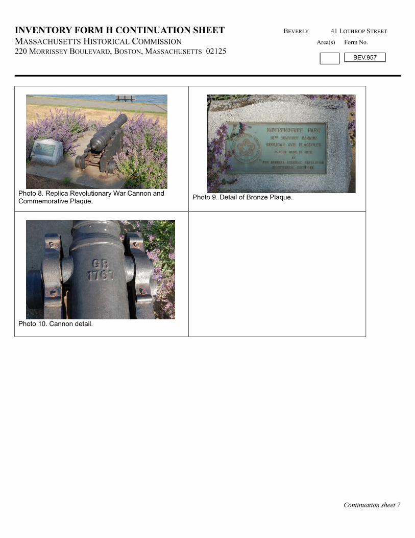
In the center of the Park, thirty feet from either side of the Boulder, is a pair of replica Revolutionary War Cannons and Commemorative Plaques (1978). The Plaques are set into granite bases, and both the Plaques and the Cannons are set on concrete pads. (Photo 8) Ten feet away from the concrete pads, toward the Boulder, are two Flagpoles (1978). The inscription on the Plaques (Photo 9) reads:
INDEPENDENCE PARK18TH CENTURY CANNON
Continuation sheet 1
BEV.957

INVENTORY FORM H CONTINUATION SHEET BEVERLY 41 LOTHROP STREET
MASSACHUSETTS HISTORICAL COMMISSION Area(s) Form No.
220 MORRISSEY BOULEVARD, BOSTON, MASSACHUSETTS 02125
REPLICAS AND FLAGPOLESPLACED HERE IN 1978
BYTHE BEVERLY AMERICAN REVOLUTION
BICENTENNIAL COMMITTEE
HISTORICAL NARRATIVE
Site Significance
Beverly was the only Continental Army post outside of the Boston area established by General Washington during the Revolutionary War. The four-block parcel of land fronting the ocean that constitutes Independence Park commemorates the larger theatre of Revolutionary War action that took place at sea in Beverly Harbor and on land along Mackerel Cove, as well as the exemplary role of Colonel John Glover in the War effort. .The Independence Park site commemorates a battle between the schooner Hannah and the British Man O’War Nautilus, which took place in the waters off this site, and the first reading of the Declaration of Independence in Beverly the following year. Some of the activities commemorated on this site did not actually occur here, however.
Independence Park is significant in local history as the location of the Reading of the Declaration of Independence, which occurred under orders of General Washington at 6:00 pm on July 17, 1776. A defensive battery of three guns— one 18-pounder and two 9-pounders— were placed on the site. These guns were mounted on carriages, ordered by General Washington and sent from Framingham for the defense of the town. The Revolutionary War Cannons presently standing in Independence Park (Photo 10) are replicas of the two nine-pounder guns that were fired as part of the reading of the Declaration.
John Glover (1732-1797) was born in Salem and grew up in Marblehead. In 1759, Glover was appointed an ensign in the Third Military Foot Company, a Marblehead Militia Regiment of 1,000 men. He quickly rose through the ranks, and upon the death of Colonel Jeremiah Lee in 1775, became commander of the regiment.
Recognizing Glover's leadership skills and resourcefulness, General Washington sent Glover to Beverly to protect that port against three British warships threatening attack, guarding the military stores which had been collected to supply the Army as well as the valuable prizes and their cargoes that had been brought into the harbor by the Continental privateer vessels sailing from Beverly. Washington ordered Glover to commission and man two small naval vessels, the forerunners of Washington's Navy. Glover christened the first schooner he outfitted after his wife, Hannah, and set sail from Glover’s Wharf in Beverly. The foresight of Washington’s order was soon made apparent when the British man o’war ship Nautilus turned its sights on the Hannah in October 1775. Her captain brought the Hannah into Beverly Harbor, while citizens shot at the Nautilus from the shoreline of this site. The battle defending the Hannah and the harbor was witnessed from downtown Beverly by a group of alarmed citizens standing on the prospect of Watch Hill. Beverly voted immediately thereafter to fortify itself.
In 1775, Beverly Harbor was much narrower, and Mackerel Cove much shallower. The Independence Park shoreline extended out more than a hundred feet farther than at present, and at the southeastern corner, extended to a point several hundred feet into the sea. On this far point, Thomas Tuck built a home as early as 1660. Both Woodbury Point and Tuck’s Point had forts builton them in 1775, fortified with embrasures. Given its position close to the entrance to Beverly Harbor, Colonel Glover ordered five embrasures built on Tuck’s Point, and the main guard was kept at Tuck’s house, with sentries stationed to keep watch on theharbor and signal to any incoming ships.
At the start of 1776, the Marblehead Militia Regiment formally became the 14th Continental Regiment. The regiment marched into the lines at Beverly on January 14, 1776. The 14th Regiment’s camp comprised all the land on both sides of what is now
Continuation sheet 2
BEV.957

INVENTORY FORM H CONTINUATION SHEET BEVERLY 41 LOTHROP STREET
MASSACHUSETTS HISTORICAL COMMISSION Area(s) Form No.
220 MORRISSEY BOULEVARD, BOSTON, MASSACHUSETTS 02125
Lothrop Street, from Central Street down to and including a part of what is known as Quincy Park. The barracks were erected onthe southwestern side, on what is now known as Ward Two Playground.
As soon as the Declaration of Independence was signed, the Continental Congress ordered copies sent to the commanding officers of the continental troops. General Washington ordered all his commanders to have the Declaration read to the Army. At six o'clock on the afternoon of July 17, 1776, the regiment assembled on the parade ground, where the Declaration of Independence was read, declaring, "the United Colonies of North America, free and independent states." After the reading of theDeclaration, Colonel Glover ordered a salute of thirteen guns fired from all the batteries along the shore, followed by another salute from the vessels in the harbor. On July 19th the regiment was ordered to march to New York and later to Long Island.
Post war history
When the Salem-Beverly Bridge was built in 1788, a ropewalk that was located at the lower end of Cabot Street was moved to the Independence Park site; it remained here until 1862, when it was destroyed by fire. On the parcel that is now 53 Lothrop Street, at the north end of Independence Park, Israel Lefavour built the Queen Hotel, whichopened on June 27, 1889. A very large and extravagant structure, the southern end of the building had piazzas overlooking the harbor across the open expanse of the former ropewalk land. The hotel burned to the ground in the early 1890s, and Lefavour sold the property. The open land became popularly known as the “Queen Hotel Lot.”
Twentieth Century history
In 1906, the City purchased the ropewalk land for $14,500 from A. H. Burnett, who had acquired the parcel the preceding year from James P. DeLong. (B 1793/P 549). DeLong assembled the parcel from the four owners of this contiguous unbuilt beachfront property along Lothrop Street between Wilson and Central Streets.
Intending to establish a public park on the site, Mayor Joseph A. Wallis wrote to Beverly resident and historian Charles Woodberry, asking if he had any historical facts associated with the land recently purchased. Woodberry responded to Wallis’s request with a three-page letter recounting the narrative of Colonel Glover and the 14 th regiment and the reading of the Declaration of Independence. Woodberry concluded his letter by suggesting the name “Independence” for the park, “as being a proper and fitting one for the Park, thereby commemorating a great event in the history of the town associated with the traditions of Washington and the Continental Army.” In addition to the letter, Woodberry included a thirty-page document of excerpts from correspondence, diaries, and memoirs that bore relationship to the events taking place in Beverly during the Revolutionary War. Excerpts range from letters between Continental Congress members and General Washington, his orders to various commanders, and written recollections from Beverly residents and foot soldiers.
On February 16, 1907, Beverly’s Board of Park Commissioners voted that the park be named "Independence Park". In 1909 the sea wall was constructed of granite blocks from Rockport, three feet high. By 1919, the layout of central path and elliptical path was established. On October 12, 1929, the Colonel Ebenezer Francis Chapter of the Daughters of the American Revolution dedicated the bronze Plaque fixed to the granite boulder that sits at the center of Independence Park.In the 1930s or 1940s the retaining wall with pole railings were installed. In 1978, two Revolutionary War replica Cannons and two Flagpoles were placed on the site by the Beverly American Revolution Bicentennial Association.
BIBLIOGRAPHY and/or REFERENCES
Maps and AtlasesBerry, William J, Civil Engineer. “A Plan of a Part of Beverly in the Colony of the Massachusetts Bay, Compiled from Various Sources.” 1897. Beverly Historical Society Tuck, George O. “Map of Beverly, 1836.” Beverly Historical Society.George H. Walker & Company. Atlas of City of Beverly. Boston: 1897.George H. Walker & Company. Atlas of City of Beverly. Boston: 1907
Continuation sheet 3
BEV.957

INVENTORY FORM H CONTINUATION SHEET BEVERLY 41 LOTHROP STREET
MASSACHUSETTS HISTORICAL COMMISSION Area(s) Form No.
220 MORRISSEY BOULEVARD, BOSTON, MASSACHUSETTS 02125
Yeager & Klinge Co. Atlas of the North Shore, Beverly to Magnolia. Boston: 1919.
Archives & RepositoriesSouthern Essex County Registry of Deeds http://salemdeeds.com/salemdeeds/Default2.aspx
Secondary SourcesCollins, George. “Beverly Men in the War of Independence.” Remarks before the Beverly Historical Society on the occasion of
the unveiling of the commemorative tablet, April 9,1930. Beverly Public Library“Glover’s Marblehead Regiment”, web site of Glover's Marblehead Regiment, the Celebrated 14th Continental
accessed May 12, 2016. http://gloversregiment.org/historyglover.phpHall, Stephen. “The Fiery Death of Beverly’s Queen Hotel.” Beverly Citizen, May 9, 2007.“The Parks of Beverly Massachusetts: A Survey of the Parks of Beverly and the Work of the Beverly Improvement Society.”
Beverly Improvement Society publication, 1973.Stone, Edwin M. History of Beverly, A Civil and Ecclesiastical, From its Settlement in 1630 to 1842. Boston: James Munroe and
Company, 1843.Woodberry, Charles. “Independence Park, Beverly Massachusetts. Historical Events Associated with the Ground. Compiled by
Charles Woodberry from Original Manuscripts, submitted to Joseph Wallis, Mayor, December 1, 1906. Unpublished ms,Beverly Historical Society
DATA SHEET
MHC # Parcel ID Address Historic Name Date StyleBEV.957 5-462 41 Lothrop St Independence Park 1906 NABEV.981 5-462 41 Lothrop St 2 Revolutionary War cannons (replicas) with
Commemorative Plaques 1978 NA
BEV.982 5-462 41 Lothrop St Flagpoles (2) 1978 NABEV.983 5-462 41 Lothrop St Boulder with Commemorative Plaque 1930 NA
Continuation sheet 4
BEV.957

INVENTORY FORM H CONTINUATION SHEET BEVERLY 41 LOTHROP STREET
MASSACHUSETTS HISTORICAL COMMISSION Area(s) Form No.
220 MORRISSEY BOULEVARD, BOSTON, MASSACHUSETTS 02125
SKETCH MAP (north at top)
Source: Google aerial view, 2016
SUPPLEMENTARY IMAGES
Continuation sheet 5
BEV.957

INVENTORY FORM H CONTINUATION SHEET BEVERLY 41 LOTHROP STREET
MASSACHUSETTS HISTORICAL COMMISSION Area(s) Form No.
220 MORRISSEY BOULEVARD, BOSTON, MASSACHUSETTS 02125
Photo 2. View south past Flagpole and replica Cannon to breakwater and Salem Neck.
Photo 3. Concrete steps leading down from Lothrop StSidewalk. View northwest.
Photo 4. Path to Boulder with Plaque; Beverly Harborand Salem Neck in distance. View southeast.
Photo 5. Bronze Plaque inset in granite boulder.
Photo 6. Concrete steps and side walls; granite sea wall along beach. View northwest.
Photo 7. View north along remaining section of steel pipe railing, north of steps to beach.
Continuation sheet 6
BEV.957
INVENTORY FORM H CONTINUATION SHEET BEVERLY 41 LOTHROP STREET
MASSACHUSETTS HISTORICAL COMMISSION Area(s) Form No.
220 MORRISSEY BOULEVARD, BOSTON, MASSACHUSETTS 02125
Photo 8. Replica Revolutionary War Cannon and Commemorative Plaque.
Photo 9. Detail of Bronze Plaque.
Photo 10. Cannon detail.
Continuation sheet 7
BEV.957