Embed Size (px)
Citation preview

REPORT DOCUMENTATION PAGE Form Approved OMB No. 0704-01, 8
The public reporting burden for this collection of information is estimated to average 1 hour per response, including the time for reviewing instructions, searching existing data sources, gathering and maintaining the data needed, and completing and reviewing the collection of information. Send comments regarding this burden estimate or any other aspect of this collection of information, including suggestions for reducing the burden, to the Department of Defense, Executive Services and Communications Directorate (0704-0188). Respondents should be aware that notwithstanding any other provision of law, no person shall be subject to any penalty for failing to comply with a collection of information if it does not display a ';urrently valid OMB control number.
PLEASE DO NOT RETURN YOUR FORM TO THE ABOVE ORGANIZATION.
1. REPORT DATE (DD-MM- YYYY) 12-08-2009
2. REPORT TYPE Journal Article
3. DATES COVERED (From - To)
4. TITLE AND SUBTITLE
U.S. GODAE: Global Ocean Prediction with the HYbrid Coordinate Ocean Model (HYCOM)
6. AUTHOR(S) E.P. Chassignet, H.E. Hurlburt, E.J. Metzger, O.M. Smedstad, J.A. Cummings, G.R. Halliwell, R. Bleck, R. Baraille, A.J. Wallcraft, C. Lozano, H.L. Tolman, A. Srinivasan, S. Hankin, P. Cornillon, R. Weisberg, A. Barth, R. He, F. Werner, and J. Wilkin
5a. CONTRACT NUMBER
5b. GRANT NUMBER
5c. PROGRAM ELEMENT NUMBER
0602435N
5d. PROJECT NUMBER
5e. TASK NUMBER
5f. WORK UNIT NUMBER
73-8677-08-5
7. PERFORMING ORGANIZATION NAME(S) AND ADDRESS(ES)
Naval Research Laboratory Oceanography Division Stennis Space Center, MS 39529-5004
9. SPONSORING/MONITORING AGENCY NAME(S) AND ADDRESS(ES)
Office of Naval Research 800 N. Quincy St. Arlington, VA 22217-5660
8. PERFORMING ORGANIZATION REPORT NUMBER
NRL/JA/7304-08-8 135
10. SPONSOR/MONITOR'S ACIONYM(S)
ONR
11. SPONSOR/MONITORS REPORT NUMBER(S)
12. DISTRIBUTION/AVAILABILITY STATEMENT
Approved for public release, distribution is unlimited
13. SUPPLEMENTARY NOTES 20090821528 14. ABSTRACT During the past five to ten years, a broad partnership of institutions under NOPP sponsorship has collaborated in developing and demonstrating the lerformance and application of eddy-resolving, real-time global- and basin-scale ocean prediction systems using the HYbrid Coordinate Ocean Model (HYCOMl The partnership represents a broad spectrum of the oceanographic community, bringing together academia, federal agencies, and industry/commercial cntitii ,, and spanning modeling, data assimilation, data management and serving, observational capabilities, and application of HYCOM prediction system outputs. In addnion to providing real-time, eddy-resolving global- and basin-scale ocean prediction systems for the US Navy and NOAA, this project also offered an outstandinj opportunity for NOAA-Navy collaboration and cooperation, ranging from research to the operational level. This paper provides an overview of the global HYCOM icean prediction system and highlights some of its achievements. An important outcome of this effort is the capability of the global system to provide boundary conditions to even higherresolution regional and coastal models.
15. SUBJECT TERMS
HYCOM, data assimilation, NOPP, ocean prediction systems
16. SECURITY CLASSIFICATION OF:
a. REPORT
t Inclassified
b. ABSTRACT
Unclassified
c. THIS PAGE
Unclassified
17. LIMITATION OF ABSTRACT
UL
18. NUMBER OF PAGES
12
19a. NAME OF RESPONSIBLE PERSON Harley E. Hurlburt 19b. TELEPHONE NUMBER /Include area co W
228-688-4626
Standard Form 2!)8 (Rev. 8/98) Prescribed by ANSI St . Z39 18

PUBLICATION OR PRESENTATION RELEASE REQUEST Pubkey: 5926 NRLINST 5600.2
|1. REFERENCES AND ENCLOSURES 2. TYPE OF PUBLICATION OR PRESENTATION 3. ADMINISTRATIVE INFORMATION
Ref: (a) NRL Instruction 5600.2 (b) NRL Instruction 5510.40D
End: (1) Two copies of subject paper (or abstract)
' ( ) Abstract only, published ( ( )Book ( ( ) Conference Proceedings (
(refereed) ( ) Invited speaker ( (X ) Journal article (refereed) ( ( ) Oral Presentation, published ( ( ) Other, explain
) Abstract only, not published ) Book chapter ) Conference Proceedings
(not refereed) ) Multimedia report ) Journal article (not refereed) ) Oral Presentation, not published
STRN NRL/JA/7304-08-8335 Route Sheet No. 7304/
Job Order No. 73-8677-08-5 Classification X u Sponsor ONR
approval obtainei yes
4. AUTHOR
Title of Paper or Presentation U.S. GODAE: Global Ocean Prediction with the HYbrid Coordinate Ocean Model (HYCOM)
Author(s) Name(s) (First.MI.Last), Code, Affiliation if not NRL
Eric Chassignet, Harley E. Hurlburt, E. Joseph Metzger, Ole Martin Smedstad, James A. Cummings, G. Halliwell, R. Bi jck, Remy Baraille, Alan J. Wallcraft, C. J. Lozano, Hendrik Tolman, A. Srinivasan, Steve Hankin, Peter Comillon, Robert Weisberg, A. Jarth, R. He, Cisco Werner, John Wilkin
It is intended to offer this paper to the (Name of Conference)
(Date, Place and Classification of Conference)
and/or for publication in Oceanography Magazine, Unclassified (Name and Classification of Publication) (Name of Publii ner)
After presentation or publication, pertinent publication/presentation data will be entered in the publications data base, in £ ;cordance with reference (a). It is the opinion of the author that the subject paper (is ) (is not *) classified, in accordance with reference (b). This paper does not violate any disclosure of trade secrets or suggestions of outside individuals or concerns which have oeen communicated to the Laboratory in confidence. This paper (does ) (does not X) contain any militarily critical tec hnology. This subject paper (has ) (has never X ) been incorporated in an official NRL Report.
Harley E. Hurlburt, 7323 Name and Code (Principal Author)
H»&, I
(Signature)
5. ROUTING/APPROVAL
CODE SIGNATURE DATE COMMENTS
Author(s) •'/•-< I !/.,,(• "f A/.: V XL
•-'' %:lri Need by / I /"' •/
Publicly accessible sourc ;s used for this publication
Section Head
/ n
CJJI Branch Head
Division Head
Ruth H. Preller, 7300
Security, Code 1226
Office of Counsel,Code 1008.3
ADOR/Director NCST E. R. Franchi, 7000
Public Affairs (Unclassified/ Unlimited Only), Code 7030 4
1. Release of this paper 2. To the best knowledge subject matter of this pa| (has never x ) been
5 approved, of this Division,
er (has ) lassified.
the
1. Paper or abstract was leased. 2. A copy is filed in this ol ice. 6* w-4
/ -.. i ~-
Division, Code
Author, Code
HQ-NRL 5511/6 (Rev. 12-98) (e) THIS FORM CANCELS AND SUPERSEDES ALL PREVIOUS VERSIONS
J

4 v^sbB«6#^U:bii8Hcd (-^^rSciwnly. wftfelishM.
' .^^fr^??!^ .'•••.••.•"••; '•••'.'. " • •=*' "".: frot-raifereecJ) ^'Ijfivllefispeaka1 •. />: " ''r ^.MOIiimedlairepbrt .X|J•^a'-s«ic!citrofsrgeiJ) [./) Jottrfi8i:articte(not referoed)..
SWj|^M^$«^M. RoutWSh'eet No.7384/: ___ JdbOrderNo. ;7£^8B7?-0B-§ Glaesiricafion X u c
Sponsor: /•?y.;J3^a.^"7l__
approval oBtalned _ yes X no
(*
'Alat^:M^
eistoo WarttBf,.- Jtfhrvi^llkin "'"'. ' ''•'•-••'•/.''':
A,Cumrrtlngs, G. Hilflwell, ft Bleck, Rewy Bawille, Cornlllon, Rob'drt We'Sbtsrg, A. Bart1 >, R. Me,
This ? '^ *;PA
(Nettie
— •**—• n 1. ...... .. -•-•-,.
jJDmyglacetancI aasslfleefo^oWonfo'reneB)
u i3me;u|ji^oH^Hina>duij.iun^at^e.-suoie6t;paper(is-l. ,. Mrs not ^jciassmed, in accordance, winrreference (b).:
This-paper da'fe£#$$cV^ej8<^^ communliMted>ti>ift»fc^ Tniis.papef-:(doe3;" ' -Hdoaslrfot X)containany militarily critical technology
'";irieoTpqratedln^n.offlcialiNRt.. Report.
"SecTion Ryf'cHs
ii uf iffV-r>tTiiMiyiJfi fc------• •' i ••!•••-*tt'.' S^-r-.v-^,i--^\i*?.-.'-.-i:,«rv-
JL«_ SccoHify^GwJe'- ^D.;,
OfrTcPoTicaucisi ^pwav^c.-'.„"••>. -
ADOR/Olrecto'r'NeST., -,
PubiferAffaire^t'rt'dJa^iw&W'-..' :
••vjt*i°../y#<,.*>-? •^.llX:tK.<:.',»,i,'/'.<. - ••'•> .t-J.^-iw.4
-Jgyv.SM.r^f'S/^.^-.^<--,-A,-t;-.'-1.
&%j?s,yj Vo , ••-•.^.'•'••g:
z-Zrr /J'.^r-r. i^—LV f-A,»r\ ^i* ; L_
••.••ai,^^^
^bl^'6c664'alBle^6oreosu9-:l«.roTlhl5-puWicatiori
y^>r
•yf''T / / wm^ ..,—^v
/
//-. w AMb
-v - 'TV^I'- • ->M ; BJ; Ti'goieasfr owniE paper is app' aved. 2f'TiS,(h8iBea( knoWledge o(:lhh; Olvlaion. Ihn aiAj/ecl matter o( lhl9.pspBr.(lV>i ••.' ) (hSaittBtferf^^jr^ Jbeen clasr-ir nd.
t. P8J»er orabstract.wasrefeas [fl. 2; A copy Isfilw) In thia office <C Sf^,
K-.; f
HQ-NRt-.'fe5'1Svie^Re(r:*5%^X'i^> ^*fi^'\%sfr$>mK^^^ '

NOPP SPECIAL ISSUE FEATURE
US GODAE Global Ocean Prediction with the
HYbrid Coordinate Ocean Model (HYCOM)
BY ERIC P. CHASSICNET, HARLEY E. HURLBURT, E. JOSEPH METZCER,
OLE MARTIN SMEDSTAD, JAMES A. CUMMINGS,
GEORGE R. HALLIWELL, RAINER RLECK, REMY BARAILLE,
ALAN J. WALLCRAFT, CARLOS LOZANO, HENDRIK L. TOLMAN,
ASHWANTH SRINIVASAN, STEVE HANKIN, PETER CORNILLON,
ROBERT WEISBERG, ALEXANDER BARTH, RLJOYING HE,
FRANCISCO WERNER, AND JOHN WILKIN

A B S T R A C i During the past five to ten years, a broad partnership of institutions
under NOPP sponsorship has collaborated in developing and demonstrating the
performance and application of eddy-resolving, real-time global- and basin-scale
ocean prediction systems using the HYbrid Coordinate Ocean Model (HYCOM).
The partnership represents a broad spectrum of the oceanographic community,
bringing together academia, federal agencies, and industry/commercial entities, and
spanning modeling, data assimilation, data management and serving, observational
capabilities, and application of HYCOM prediction system outputs. In addition to
providing real-time, eddy-resolving global- and basin-scale ocean prediction systems
for the US Navy and NOAA, this project also offered an outstanding opportunity for
NOAA-Navy collaboration and cooperation, ranging from research to the operational
level. This paper provides an overview of the global HYCOM ocean prediction system
and highlights some of its achievements. An important outcome of this effort is
the capability of the global system to provide boundary conditions to even higher-
resolution regional and coastal models.
INTRODUCTION
A broad partnership of institutions has
collaborated over the past five to ten
years to develop and demonstrate the
performance and application of eddy-
resolving, real-time global- and basin-
scale ocean prediction systems using
the HYbrid Coordinate Ocean Model
(HYCOM). These systems are in the
process of being transitioned to opera-
tional use by the US Navy at the Naval
Oceanographic Office (NAVOCEANO),
Stennis Space Center, MS, and by the
National Oceanic and Atmospheric
Administration (NOAA) at the National
Centers for Environmental Prediction
(NCEP), Washington, DC. The systems
run efficiently on a variety of massively
parallel computers and include sophis-
ticated, but relatively inexpensive, data
assimilation techniques for satellite
altimeter sea surface height and sea
surface temperature as well as in situ
temperature, salinity, and float displace-
ment. The partnership represents a broad
spectrum of the oceanographic commu-
nity, bringing together academia, federal
agencies, and industry/commercial
entities in activities that span modeling,
data assimilation, data management
and serving, observational capabilities,
and application of HYCOM predic-
tion system outputs. All participating
institutions were committed and the
collaborative partnership provided an
opportunity to leverage and accelerate
the efforts of existing and planned
projects, consequently producing a high-
quality product that should collectively
serve a wider range of users than would
the individual projects.
The collaboration was initiated in the
late 1990s by ocean modelers at the Naval
Research Laboratory, Stennis, MS, who
approached colleagues at the University
of Miami's Rosenstiel School of Marine
and Atmospheric Science regarding an
extension of the range of applicability of
the US Navy operational ocean predic-
tion system to coastal regions (e.g., the
US Navy systems at the time were seri-
ously limited in shallow water and in
handling the transition from deep to
shallow water). HYCOM (Bleck, 2002)
was therefore designed to extend the
range of existing operational Ocean
General Circulation Models (OGCMs).
The freedom to adjust the vertical spacing
of the generalized (or hybrid) coordinate
layers in HYCOM simplifies the numer-
ical implementation of several processes
and allows for a smooth transition
from the deep ocean to coastal regimes.
HYCOM retains many of the charac-
teristics of its predecessor, the Miami
Isopycnic Coordinate Ocean Model
(Bleck et al., 1992; Bleck and Chassignet,
1994), while allowing coordinates to
locally deviate from isopycnals wherever
the latter may fold, outcrop, or generally
provide inadequate vertical resolution.
The collaboration led to the development
of a consortium for hybrid-coordinate
data assimilative ocean modeling
supported by NOPP to make HYCOM
a state-of-the-art community ocean
model with data assimilation capability
that could: (1) be used in a wide range of
ocean-related research, (2) become the
next-generation eddy-resolving global
ocean prediction system, and (3) be
coupled to a variety of other models,
including littoral, atmospheric, ice, and
biochemical models. One outcome of this
collaboration was the establishment of a
near-real-time North Atlantic prediction
system based on HYCOM.
In 2003, NOAA NCEP joined forces
with the HYCOM consortium in
responding to a NOPP Broad Agency
Announcement aimed at "imple-
menting the initial, preoperational
US contribution(s) to the Global
Ocean Data Assimilation Experiment
(GODAE)." These efforts were intended
to be pilot projects under Ocean.US,
the National Office for Integrated and
Sustained Ocean Observations, and to
Oceanography June 2009 49

eventually lead to sustained operational
efforts supported by US agencies such
as NOAA and the Navy. The HYCOM
consortium therefore became one of the
US components of GODAE, a coordi-
nated international system of observa-
tions, communications, modeling,
and assimilation that delivers regular,
comprehensive information on the
state of the ocean (see Chassignet and
Verron, 2006, for a review). Navy and
NOAA applications, such as maritime
safety, fisheries, the offshore industry,
and management of shelf/coastal areas,
are among the expected beneficiaries of
the HYCOM ocean prediction systems
(http://www.hycom.org). More specifi-
cally, the precise knowledge and predic-
tion of ocean mesoscale features helps
the Navy, NOAA, the Coast Guard,
industry, and fisheries with endeavors
such as ship and submarine routing,
search and rescue, oil spill drift predic-
tion, open-ocean ecosystem monitoring,
Eric P. Chassignet ([email protected]) is Professor and Director, Center for
Ocean-Atmospheric Prediction Studies, Florida State University, Tallahassee, FL, USA.
Harley E. Hurlburt is Senior Scientist for Ocean Modeling and Prediction, Naval Research
Laboratory (NRL), Stennis Space Center, MS, USA. E. Joseph Metzger is Meteorologist,
Ocean Dynamics and Prediction Branch, NRL, Stennis Space Center, MS, USA.
Ole Martin Smedstad is Principal Scientist, QinetiQ North America-Technology Solutions
Croup, Stennis Space Center, MS, USA. James A. Cummings is Oceanographer, Ocean
Dynamics and Prediction Branch, NRL, Stennis Space Center, MS, USA. George R. Halliwell
is Research Scientist, Atlantic Oceanographic and Meteorological Laboratory, National
Oceanic and Atmospheric Administration (NOAA), Miami, FL, USA. Rainer Bleck
is Research Scientist, Qoddard Institute for Space Studies, National Aeronautics and
Space Administration, New York, NY, USA, and Earth Systems Research Laboratory,
NOAA, Boulder, CO, USA. Remy Baraille is Research Scientist, Service Hydrographique
et Oceanographique de la Marine, Toulouse, France. Alan J. Wallcraft is Computer
Scientist, Ocean Dynamics and Prediction Branch, NRL, Stennis Space Center, MS, USA.
Carlos Lozano is Physical Scientist, Environmental Modeling Center, National Centers
for Environmental Prediction, NOAA, Camp Springs, MD, USA. Hendrik L. Tolman
is Branch Chief, Environmental Modeling Center, National Centers for Environmental
Prediction, Marine Modeling and Analysis Branch, NOAA, Camp Springs, MD, USA.
Ashwanth Srinivasan is Research Assistant Professor, Division of Meteorology and
Oceanography, Rosenstiel School of Marine and Atmospheric Science, University of
Miami, Miami, FL, USA. Steve Hankin is Research Scientist, Pacific Marine Environmental
Laboratory, NOAA, Seattle, WA, USA. Peter Comillon is Professor, Graduate School of
Oceanography, University of Rhode Island, Narragansett, Rl, USA. Robert Weisberg is
Professor, College of Marine Science, University of South Florida, St. Petersburg FL, USA.
Alexander Barth is Research Scientist, CeoHydrodynamics and Environment Research,
University of Liege, Liege, Belgium. Ruoying He is Associate Professor, Department of
Marine, Earth and Atmospheric Sciences, North Carolina State University, Raleigh, NC,
USA. Francisco Werner is Director and Professor, Institute of Marine and Coastal Sciences,
Rutgers University, New Brunswick, N), USA. John Wilkin is Associate Professor, Institute of
Marine and Coastal Sciences, Rutgers University, New Brunswick, Nj, USA.
fisheries management, and short-range
coupled atmosphere-ocean, coastal, and
nearshore environmental forecasting.
In addition to operational eddy-
resolving global- and basin-scale ocean
prediction systems for the US Navy
and NOAA, respectively, this project
offered an outstanding opportunity for
NOAA-Navy collaboration and coop-
eration ranging from research to the
operational level.
BACKGROUND
Over the past several decades, numerical
modeling studies have demonstrated
progress in both model architecture
and the availability of computational
resources to the scientific community.
Perhaps the most noticeable aspect of
these advances has been the evolution
from simulations on coarse-resolution
horizontal/vertical grids outlining basins
of simplified geometry and bathymetry
and forced by idealized stresses, to fine-
resolution simulations incorporating
realistic coastal definition and bottom
topography and forced by observational
data on relatively short time scales
(Hurlburt and Hogan, 2000; Smith et al.,
2000; Chassignet and Garraffo, 2001;
Maltrud and McClean, 2005; Hurlburt
et al, 2008). The choice of the vertical
coordinate system, however, remains
one of the most important aspects of an
ocean model's design. In practice, the
representation and parameterization of
processes not resolved by the model grid
are often directly linked to the vertical
coordinate choice (Griffies et al., 2000).
Oceanic general circulation models
traditionally represent the vertical in
a series of discrete intervals in either a
depth, density, or terrain-following unit.
Because none of the three main vertical
50 Oceanography Vol.22, No.2

coordinates (depth, density, and terrain-
following) provide universal optimality, it
is natural to envision a hybrid approach
that combines the best features of each
vertical coordinate. Isopycnic (potential
density-tracking) layers work best for
modeling the deep stratified ocean; levels
at constant fixed depth or pressure are
best for providing high vertical resolution
near the surface within the mixed layer;
and terrain-following levels are often the
best choice for modeling shallow coastal
regions. In HYCOM, the optimal vertical
coordinate distribution of the three
vertical coordinate types is chosen at
every time step and in every grid column
individually. The default configuration of
HYCOM is isopycnic in the open strati-
fied ocean, but it makes a dynamically
and geometrically smooth transition to
terrain-following coordinates in shallow
coastal regions and to fixed pressure-level
coordinates in the surface mixed layer
and/or unstratified open seas. In doing
so, the model takes advantage of the
different coordinate types in optimally
simulating coastal and open-ocean circu-
lation features (Chassignet et al., 2003,
2006, 2007). A user-chosen option allows
specification of the vertical coordinate
separation that controls the transition
among the three coordinate systems.
The assignment of additional coordinate
surfaces to the oceanic mixed layer also
allows the straightforward implementa-
tion of multiple vertical mixing turbu-
lence closure schemes (Halliwell, 2004).
The choice of the vertical mixing param-
eterization is also of importance in areas
of strong entrainment, such as overflows.
Data assimilation is essential for
ocean prediction because: (a) many
ocean phenomena are due to nonlinear
processes (i.e., flow instabilities) and
thus are not a deterministic response to
atmospheric forcing, (b) errors exist in
the atmospheric forcing, and (c) ocean
models are imperfect, including limita-
tions in numerical algorithms and in
resolution. Most of the information about
the ocean surface's space-time variability
is obtained remotely from instruments
aboard satellites (sea surface height [SSH]
and sea surface temperature [SST]), but
these observations are insufficient for
specifying the subsurface variability.
Vertical profiles from expendable
bathythermographs (XBT), conductivity-
temperature-depth (CTD) profilers,
and profiling floats (e.g., Argo, which
measures temperature and salinity in
the upper 2000 m of the ocean) provide
another substantial source of data. Even
together, these data sets are insufficient
to determine the state of the ocean
completely, so it is necessary to exploit
prior statistical knowledge based on
past observations as well as our present
understanding of ocean dynamics. By
combining all of these observations
through data assimilation into an ocean
model, it is possible, in principle, to
produce a dynamically consistent depic-
tion of the ocean. However, in order
to have any predictive capabilities, it
is extremely important that the freely
evolving ocean model (i.e., non-data-
assimilative model) is skilled in repre-
senting ocean features of interest.
To properly assimilate the SSH anoma-
lies determined from satellite altimeter
data, the oceanic mean SSH over the
altimeter observation period must be
provided. In this mean, it is essential that
the mean current systems and associated
SSH fronts be accurately represented in
terms of position, amplitude, and sharp-
ness. Unfortunately, Earths geoid is not
presently known with sufficient accuracy
for this purpose, and coarse hydrographic
climatologies (~ 0.5°-l° horizontal
resolution) cannot provide the spatial
resolution necessary when assimilating
SSH in an eddy-resolving model (hori-
zontal grid spacing of 1/10° or finer). At
these scales of interest, it is essential to
have the observed means of boundary
currents and associated fronts sharply
defined (Hurlburt et al., 2008). Figure 1
shows the climatological mean derived
on a 0.5° grid using surface drifters by
Maximenko and Niiler (2005) as well
as the mean currently used in the Navy
global HYCOM prediction system
(see following section for details). The
HYCOM mean was constructed as
follows: a five-year mean SSH field from
a non-data-assimilative 1/12° global
HYCOM run was compared to available
climatologies, and a rubber-sheeting
technique (Carnes et al., 1996) was used
to modify the model mean in two regions
(the Gulf Stream and the Kuroshio)
where the western boundary current
extensions were not well represented
and where an accurate frontal location
is crucial for ocean prediction. Rubber
sheeting involves a suite of computer
programs that operate on SSH fields,
overlaying contours from a reference field
and moving masses.
THE HYCOM OCEAN
PREDICTION SYSTEMS
Two systems are currently run in real
time by the US Navy at NAVOCEANO,
Stennis Space Center, MS, and by
NOAA at NCEP, Washington, DC
(http://www.hycom.org).
The first system is the NOAA Real
Time Ocean Forecast System for the
Atlantic (RTOFS-Atlantic), which has
Oceanography June 2009 51

60'N
I* H -14 12 •OS -08 -04 <! 01 0 4 OS OS
Figure 1. The top panel shows mean sea surface height (SSH; in cm) derived from surface drifters
(Maximenko and Niiler. 200S), and the bottom panel shows the same from a non-data-assimila-
tive HYbrid Coordinate Ocean Model (HYCOM) run corrected in the Gulf Stream and Kuroshio
regions using a rubber-sheeting technique. The RMS difference between the two fields is 9.2 cm.
been running in real time since 2005.
The Atlantic domain spans 25°S to 76°N
with a horizontal resolution varying
from 4 km near the US coastline to
20 km near the African coast. The system
is run daily with one-day nowcasts
and five-day forecasts. Prior to June
2007, only the sea surface temperature
was assimilated. In June 2007, NOAA
implemented the 3D-variational data
assimilation of: (1) sea surface tempera-
ture and sea surface height (Jason-1,
Geosat Follow-On [GFO], and soon
Envisat), (2) temperature and salinity
profile assimilation (e.g., Argo, CTDs,
moorings), and (3) GOES data. Plans
are to expand this system globally using
the US Navy configuration described
in the following paragraph. The NCEP
RTOFS-Atlantic model data is distrib-
uted in real time through NCEP's
operational ftp server (ftp://ftpprd.ncep.
noaa.gov) and the NOAA Operational
Model Archive and Distribution System
(NOMADS; http://nomads6.ncdc.noaa.
gov/ncep_data/index.html) server. The
latter server is also using Open Project
for a Network Data Access Protocol
(OPeNDAP) middleware as a data-access
method. NCEP's RTOFS-Atlantic model
data is also archived at the National
Oceanographic Data Center (NODC,
http://data.nodc.noaa.gov/ncep/rtofs).
The second system is the global US
Navy nowcast/forecast system using
the 1/12° global HYCOM (6.5-km grid
spacing on average, 3.5-km grid spacing
at the North Pole, and 32 hybrid layers
in the vertical), which has been running
in near real time since December 2006
and in real time since February 2007.
The current ice model is thermody-
namic, but it will soon include more
physics as it is upgraded to the Polar Ice
Prediction System (PIPS, based on the
Los Alamos ice model known as CICE).
The model is currently running daily on
379 processors on an IBM Power 5+ at
NAVOCEANO using a part of the opera-
tional allocation on the machine. The
daily run consists of a five-day hindcast
and a five-day forecast and takes about 15
wall clock hours. The system assimilates
(1) SSH (Envisat, GFO, and Jason-1),
(2) SST (all available satellite and in
situ sources), (3) all available in situ
temperature and salinity profiles (e.g.,
Argo, CTDs, moorings), and (4) Special
Sensor Microwave/Imager (SSMI) sea ice
concentration. The three-dimensional
multivariate optimum interpolation
Navy Coupled Ocean Data Assimilation
(NCODA) system (Cummings, 2005) is
the assimilation technique. The NCODA
horizontal correlations are multivariate
in geopotential and velocity, thereby
permitting adjustments (increments)
to the mass field to be correlated with
adjustments to the flow field. The
velocity adjustments are in geostrophic
balance with the geopotential incre-
ments, and the geopotential increments
are in hydrostatic agreement with the
temperature and salinity increments.
Either the Cooper and Haines (1996)
technique or synthetic temperature and
52 Oceanography Vol.22, No.2

10 20 forecast day
Figure 2. Verification of 30-day ocean forecasts: median SSH anomaly correlation vs. forecast length in comparison with the verifying analysis for the
global US Navy HYCOM over the world ocean and five subregions. The red curves verify forecasts using operational atmospheric forcing, which reverts
toward climatology after five days. The green curves verify "forecasts" with analysis quality forcing for the duration, and the blue curves verify forecasts
of persistence (i.e., no change from the initial state). The plots show median statistics over twenty 30 day HYCOM forecasts initialized during January
2004-December 2005, a period when data from three nadir-beam altimeters, Envisat, CEOSAT Follow-on, and |ason-1, were assimilated. The reader is
referred to Hurlburt et al. (2008) and an article scheduled for the September 2009 issue of Oceanography lor a more detailed discussion of these results.
salinity profiles (Fox et al., 2002) can be
used for downward projection of SSH
and SST. Figure 2 shows an example of
forecast performance.
Validation of the results is underway
using independent data with a focus on
the large-scale circulation features, SSH
variability, eddy kinetic energy, mixed-
layer depth, vertical profiles of tempera-
ture and salinity, SST, and coastal sea
levels. Figures 3 and 4 show examples for
the Gulf Stream region while Figure 5 documents the performance of HYCOM
in representing the mixed-layer depth.
HYCOM is also an active participant in
the international GODAE comparison of
global ocean forecasting systems.
DISTRIBUTION OF
GLOBAL HYCOM HINDCASTS
AND FORECASTS
The model outputs from the global
US Navy hindcast experiment from
November 2003 to present are avail- able through the HYCOM consortium
Web page, http://www.hycom.org. The
HYCOM data distribution team devel-
oped and implemented a comprehensive
data management and distribution
strategy that allowed easy and efficient
access to the global HYCOM-based
ocean prediction system output to
(a) coastal and regional modeling
groups, (b) the wider oceanographic and
scientific community, including climate
and ecosystem researchers, and (c) the
general public. The outreach system
consists of a Web server that acts as a
gateway to backend data management,
distribution, and visualization applica-
tions (http://www.hycom.org/dataserver). These applications enable end users to
obtain a broad range of services such as
browsing of, for example, data sets, GIF
images, NetCDF files, and FTP requests
of data. The 100 terabytes HYCOM Data
Sharing System is built upon two existing
software components: OPeNDAP (see
article by Cornillon et al., this issue)
and the Live Access Server (LAS; http://
ferret.pmel.noaa.gov/LAS/). These tools
and their data distribution methods are
Oceanography June 2009 S3

40*-
yy
20*-
B'.O.-IV.
' ""N
eo*w ro 60* eo* 40*
Figure 3. Surface (top panels) and 700 m (lower panels) eddy kinetic energy from observations (left panels) and HYCOM (right
panels) over the period 2004-2006. The observed surface eddy kinetic energy (upper left panel) is from Fratantoni (2001) and the
700-m eddy kinetic energy (lower left panel) is from Schmitz (1996). The units are in em's ".The Gulf Stream north wall position
± 1 standard deviation is overlaid on the top panels.
see surt height 20080908 [90.3] Figure 4. Modeled analysis of the sea
surface height field on September 8, 2008.
The white line represents the independent
frontal analysis of sea surface temperature
observations performed by the Naval
Oceanographic Office.
54 Oceanography Vol.22, No.2

MLD MdBE. 6/07-5/08, HYCOM-OBS, -6.6m, 52.8% |MdBEI|<10. RMSE-39.7, N-66387 90°N -*-1 ' ' ' ' ' ' ' ' I i I
Figure 5. Median bias error (in m) of mixed layer depth (MLD) calculated from simulated and approximately 66.000 unassimilated
observed profiles over the period )une 2007-May 2008. Blue (red) indicates a simulated MLD shallower (deeper) than observed; 53% of the simulated MLDsare within 10 m of the observations, and these are represented as gray. The basinwide median bias
error is -6.6 m and the RMS error is 40 m.
described below. In the current setup,
the OPeNDAP component provides the
middleware necessary to access distrib-
uted data, while the LAS functions as a
user interface and a product server. The
abstraction offered by the OPeNDAP
server also makes it possible to define a
virtual data set that LAS will act upon,
rather than physical files. An OPeNDAP "aggregation server" uses this approach
to append model time steps from many
separate files into virtual data sets. The HYCOM Data Service has been in opera-
tion for the last four years and has seen
a steady increase in the user base. In the
last year, the service received approxi-
mately 20,000 hits per month. In addition
to the numerous requests from educa-
tional institutions and researchers, this
service has been providing near-real-time
data products to several private compa-
nies in France, the Netherlands, Portugal,
and the United States.
BOUNDARY CONDITIONS FOR
REGIONAL AND COASTAL
MODELS NESTED IN HYCOM
An important attribute of the data
assimilative HYCOM system is its capa-
bility to provide boundary conditions
to even higher-resolution regional and
coastal models. The current horizontal
and vertical resolution of the global
forecasting system marginally resolves
the coastal ocean (7 km at mid latitudes,
with up to 15 terrain-following coordi-
nates over the shelf), but it is an excellent
starting point for even higher-resolution
coastal ocean prediction efforts. Several
partners within the HYCOM consortium
evaluated the boundary conditions and
demonstrated the value added by the
global and basin HYCOM data assimila-
tive system output for coastal ocean
prediction models. The inner nested
models may or may not be HYCOM
(i.e., the nesting procedure can handle any vertical grid choice). Outer model
fields are interpolated to the horizontal
and vertical grid of the nested model
throughout the entire time interval of
the nested model simulation at a time
interval specified by the user, typically
once per day. The nested model is initial-
ized from the first archive file and the
entire set of archives provides boundary
conditions during the nested run,
insuring consistency between initial and
boundary conditions. This procedure has
proven to be very robust.
Oceanography June 2009 55

32°Nr~
°M • 30UN
28°N I
26°Nk
-•"""- -'.','. ' ill/*"* ^WK^ 24°N $£t ]v\': ;':.;;r:'
90°W 88CW 84°W 82°W 80°W
18 20 22 24 26 28 Figure 6. Sea surface temperature (°C) and surface velocity fields from the Regional Ocean Modeling System (ROMS) West Florida Shelf domain (inside the dashed
lines) and the HYCOM ocean prediction system (outside the dashed lines).
WFS nested in Climatology {1 si exp WFS nested in Hycom T and S (2nd exp >
9o"w erw $4°w 8i°w WFS fully netted in Hycom (3rd exp.)
90°W 87°W 84°W fl1°W
obs. AllirneVy with MICOW MSSH
8'"W
04 -02
Figure 7. Mean sea surface height (in m) on April 2004 from the model (first three panels) and
observations (lower right panel).
We now describe examples that illus-
trate applications that benefited from the
successful partnership between coastal
ocean modelers and ocean prediction
system developers. The main goal of the
first coastal application was to assess the
impact of open boundary conditions
from the HYCOM ocean prediction
system on the dynamics and accuracy
of a regional West Florida Shelf (WFS)
model (an effort led by Robert Weisberg
at the University of South Florida). The
Gulf of Mexico Loop Current is the main
large-scale ocean feature in the WFS
domain as illustrated by Figure 6, which
shows an example of the SST and surface
velocity fields from the West Florida
Shelf domain embedded in the US Navy
HYCOM ocean prediction system (Barth
et al., 2008). The ocean model consists
of the Regional Ocean Modeling System
(ROMS) (Shchepetkin and McWilliams,
2005), and a comparison of three simu-
lations in April 2004 is displayed in
Figure 7: WFS ROMS nested in climato-
logical temperature (T) and salinity (S)
fields, WFS ROMS nested in HYCOM
T and S, and WFS ROMS fully nested
in HYCOM. April 2004 was chosen
because the Loop Current was very stable
during this month (i.e., there was no
eddy shedding and the Loop Current
trajectory was stable and close to the
climatology). A priori, the model forced
with climatology should be able to repro-
duce the deep-ocean currents reasonably
well in this situation. In the model run
with climatological T and S boundary
conditions, the Loop Current is too
weak. With an SSH maximum of 0.3 m
(upper left panel of Figure 7), the SSH is
significantly lower than the maximum
derived from altimetry (0.7 m; lower
right panel of Figure 7). By using
56 Oceanography Vol.22, No.2
HYCOM T and S (upper right panel of
Figure 7), the model is able to represent
the Loop Current more realistically. In
particular, the maximum SSH (0.6 m)
is closer to the altimetry, but is still too
low. By also using HYCOM velocity
and surface elevation (lower left panel
of Figure 7), the Loop Current strength
(maximum SSH of .66 m) comes closest
to the observations. This result indicates
that the density field alone is not suffi-
cient to completely represent the Loop
Current transport. The model results
from the three nesting configurations
were compared with a series of moorings
located on the West Florida Shelf (not
shown). The model forced with clima-
tology is too cold during summer and has
the highest RMS error of all three model
experiments. During summer, the model
experiment forced with climatology
develops an unrealistic southward coastal
current. The best temperature time series
is obtained with the WFS ROMS fully
nested in HYCOM, which shows a more
realistic current variability. The WFS
ROMS model nested in HYCOM is now
run on a daily basis and the full model
results can be accessed and visualized at
http://ocgmod 1 .marine.usf.edu/WFS/.
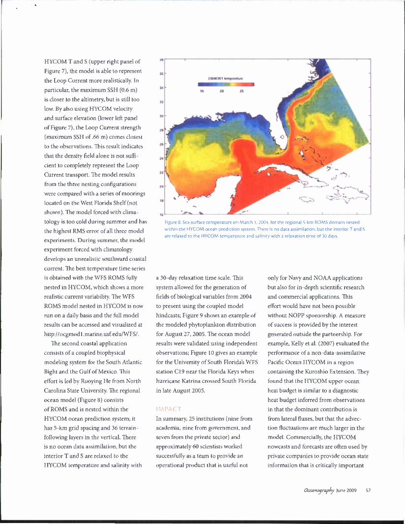
The second coastal application
consists of a coupled biophysical
modeling system for the South Atlantic
Bight and the Gulf of Mexico. This
effort is led by Ruoying He from North
Carolina State University. The regional
ocean model (Figure 8) consists
of ROMS and is nested within the
HYCOM ocean prediction system; it
has 5-km grid spacing and 36 terrain-
following layers in the vertical. There
is no ocean data assimilation, but the
interior T and S are relaxed to the
HYCOM temperature and salinity with
Figure 8. Sea surface temperature on March 1, 2004. for the regional 5-km ROMS domain nested
within the HYCOM ocean prediction system. There is no data assimilation, but the interior T and S
are relaxed to the HYCOM temperature and salinity with a relaxation time of 30 days.
a 30-day relaxation time scale. This
system allowed for the generation of
fields of biological variables from 2004
to present using the coupled model
hindcasts; Figure 9 shows an example of
the modeled phytoplankton distribution
for August 27, 2005. The ocean model
results were validated using independent
observations; Figure 10 gives an example
for the University of South Florida's WFS
station C19 near the Florida Keys when
hurricane Katrina crossed South Florida
in late August 2005.
IMPACT
In summary, 25 institutions (nine from
academia, nine from government, and
seven from the private sector) and
approximately 60 scientists worked
successfully as a team to provide an
operational product that is useful not
only for Navy and NOAA applications
but also for in-depth scientific research
and commercial applications. This
effort would have not been possible
without NOPP sponsorship. A measure
of success is provided by the interest
generated outside the partnership. For
example, Kelly et al. (2007) evaluated the
performance of a non-data-assimilative
Pacific Ocean HYCOM in a region
containing the Kuroshio Extension. They
found that the HYCOM upper ocean
heat budget is similar to a diagnostic
heat budget inferred from observations
in that the dominant contribution is
from lateral fluxes, but that the advec-
tion fluctuations are much larger in the
model. Commercially, the HYCOM
nowcasts and forecasts are often used by
private companies to provide ocean state
information that is critically important
Oceanography )une 2009 S7

35
30
25
20-
15
27-Aug-2005 00:00 Phytoplankton
[mmol/m ]
Figure 9. Modeled phytoplankton distribution (mmol m ') on August 27, 2005. The pink
dot is the location of Hurricane Katrina.
Figure 10. Modeled velocity fields versus observations at the University of South Florida's West Florida
Shelf station C19 during the passage of Hurricane Katrina in late August 200S. The modeled tempera-
ture (lower panel) and observed surface winds (upper panel) are also displayed.
to the cruising, shipping, fishing and
workboat fleets. For example, detailed
surface current information derived from
HYCOM is summarized by OCENS
(Ocean and Coastal ENviromental
Sensing, http://www.ocens.com) for their
customers who continually provide posi-
tive feedback on their accuracy.
OUTLOOK
The long-term goals of the HYCOM
consortium for the global domain are
to (a) add 3-D and 4-D variational
data assimilation, (b) increase the
horizontal resolution of the global
domain to 1/25°, (c) implement two-way
nesting, (d) implement zero depth
coastlines with wetting and drying,
and (e) include tides. The scientific
goals include, but are not be limited to:
(a) evaluation of the internal tides repre-
sentation in support of field programs,
(b) evaluation of the global model's
ability to provide boundary condi-
tions to very high resolution coastal
models, (c) interaction of the open
ocean with ice, (d) shelf-deep ocean
interactions, (e) upper-ocean physics
including mixed layer/sonic depth
representation, and (0 mixing processes.
Other research activities will focus
on coupled ocean-wave-atmosphere
prediction; bio-geo-chemical-optical
and tracer/contaminant prediction;
ecosystem analysis and prediction; and
Earth system prediction (i.e., coupled
atmosphere-ocean-ice-land).
ACKNOWLEDGEMENTS
This work was sponsored by the
National Oceanographic Partnership
Program (NOPP) and the Office of Naval
Research (ONR). It was also supported
in part by grants of computer time
58 Oceanography Vol. 22, No.2

from the Defense Department High
Performance Computing Modernization
Program at the Naval Oceanographic
Office, the Engineer Research and
Development Center, and the Army
Research Laboratory Major Shared
Resource Centers. We would like to
acknowledge the participation of the
following partners:
ACADEMIA: Florida State University
Center for Ocean-Atmospheric
Prediction Studies; University of
Miami Rosenstiel School of Marine
and Atmospheric Science; Woods
Hole Oceanographic Institution;
University of North Carolina at Chapel
Hill; North Carolina State University;
Rutgers University; University of South
Florida; Laboratoire des Ecoulements
Geophysiques et Industriels, Saint
Martin d'Heres, France; Nansen
Environmental and Remote Sensing
Center, University of Bergen, Norway.
GOVERNMENT: Naval Research
Laboratory/Stennis Space Center and
Monterey; NOAA/National Centers
for Atmospheric Prediction/Marine
Modeling and Analysis Branch; NOAA
National Ocean Service; NOAA Atlantic
Oceanographic and Meteorological
Laboratory; NOAA Pacific Marine
Environmental Laboratory; NOAA/
National Weather Service/Ocean
Prediction Center; NASA Goddard
Institute for Space Studies; Service
Hydrographique et Oceanographique
de la Marine, Brest, France.
INDUSTRY: Planning Systems Inc.;
The Open Source Project for a Network
Data Access Protocol; Horizon Marine
Inc.; Roffers Ocean Fishing Forecasting
Service Inc.; Shell Oil Company;
ExxonMobil Corp. H
REFERENCES Barth, A., A. Alvera-Azcarate, and R.H. Weisberg.
2008. Benefit of nesting a regional model into a
large-scale ocean model instead of climatology:
Application to the West Florida Shelf. Continental
Shelf Research 28:561-573.
Bleck, R. 2002. An oceanic general circulation model
framed in hybrid isopycnic-Cartesian coordinates.
Ocean Modelling 4:55-88.
Bleck, R., and E.P. Chassignet. 1994. Simulating the
oceanic circulation with isopycnic coordinate
models. Pp. 17-39 in: 7he Oceans: Physical-
Chemical Dynamics and Human Impact. S.K.
Majumdar, E.W. Miller, G.S. Forbes, R.F. Schmalz,
and A.A. Panah, eds. The Pennsylvania Academy
of Science. Bleck, R., C. Rooth, D. Hu, and L.T. Smith. 1992.
Salinity-driven transients in a wind- and thermo-
haline-forced isopycnic coordinate model of the
North Atlantic. Journal of Physical Oceanography
22:1486-1505.
Carnes, M.R., D.N. Fox, R.C. Rhodes, and O.M.
Smedstad. 1996. Data assimilation in a North
Pacific Ocean monitoring and prediction system.
Pp. 319-345 in Modern Approaches to Data
Assimilation in Ocean Modeling. P. Malanotte-
Rizzoli, ed., Elsevier, New York.
Chassignet, E.R, and Z.D. Garraffo. 2001. Viscosity
parameterization and the Gulf Stream separa-
tion. Pp. 37-41 in From Stirring to Mixing in a
Stratified Ocean. P. Muller and D. Henderson,
eds., Proceedings 'Aha Huliko'a Hawaiian
Winter Workshop. University of Hawaii,
January 15-19, 2001.
Chassignet, E.R, and J. Verron, eds. 2006. Ocean
Weather Forecasting: An Integrated View of
Oceanography. Springer, 577 pp.
Chassignet, E.R, H.E. Hurlburt, O.M. Smedstad, G.R.
Halliwell, P.J. Hogan, A.I. Wallcraft, R. Baraille, and
R. Bleck. 2007. The HYCOM (HYbrid Coordinate
Ocean Model) data assimilative system. Journal of
Marine Systems 65:60-83.
Chassignet, E.P., H.E. Hurlburt, O.M. Smedstad,
G.R. Halliwell, A.J. Wallcraft, E.J. Metzger, B.O.
Blanton, C. Lozano, D.B. Rao, P.J. Hogan, and A.
Srinivasan. 2006. Generalized vertical coordinates
for eddy-resolving global and coastal ocean
forecasts. Oceanography 19(1):118-129. Available
online at: http://www.tos.org/oceanography/issues/
issue_archive/19_l.html (accessed April 9, 2009).
Chassignet, E.R, L.T. Smith, G.R. Halliwell, and R.
Bleck. 2003. North Atlantic simulation with the
HYbrid Coordinate Ocean Model (HYCOM):
Impact of the vertical coordinate choice, reference
density, and thermobaricity. Journal of Physical
Oceanography 33:2,504-2,526.
Cooper, M., and K. Haines. 1996. Altimetric assimila-
tion with water property conservation. Journal of
Geophysical Research 101:1,059-1,078. Cummings, J.A. 2005. Operational multivariate ocean
data assimilation. Quarterly Journal of the Royal
Meteorological Society 131:3,583-3,604.
Fox, D.N., W.J. Teague, C.N. Barron, M.R. Carnes, and
CM. Lee. 2002. The Modular Ocean Data Analysis
System (MODAS). Journal of Atmospheric and
Oceanic Technology 19:240-252.
Fratantoni, D.M. 2001. North Atlantic surface circula-
tion during the 1990s observed with satellite-
tracked drifters. Journal of Geophysical Research
106:22,067-22,093.
Griffies, S.M., C. Boning, F.O. Bryan, E.P. Chassignet,
R. Gerdes, H. Hasumi, A. Hirst, A.M. Treguier,
and D. Webb. 2000. Developments in ocean climate
modelling. Ocean Modelling 2:123-192.
Halliwell, G., 2004. Evaluation of vertical coordinate
and vertical mixing algorithms in the HYbrid
Coordinate Ocean Model (HYCOM). Ocean
Modelling 7:285-322. Hurlburt, H.E., and P.J. Hogan. 2000. Impact of 1/8°
to 1/64° resolution on Gulf Stream model-data
comparisons in basin-scale subtropical Atlantic
Ocean models. Dynamics of Atmospheres and
Oceans 32:283-329.
Hurlburt, H.E., E.P. Chassignet, J.A. Cummings, A.B.
Kara, E.J. Metzger, J.F. Shriver, O.M. Smedstad, A.J.
Wallcraft, and C.N. Barron. 2008. Eddy-resolving
global ocean prediction. Pp. 353-381 in Ocean
Modeling in an Eddying Regime. M. Hecht and
H. Hasumi, eds. Geophysical Monograph 177,
American Geophysical Union, Washington, DC.
Kelly, K., L. Thompson, W. Cheng, and E.J.
Metzger. 2007. Evaluation of HYCOM in the
Kuroshio Extension region using new metrics.
Journal of Geophysical Research 112, C01004,
doi:10.1029/2006JC003614.
Maltrud, M.E., and J.L. McClean. 2005. An eddy
resolving global 1/10° ocean simulation. Ocean
Modelling 8:31-54. Maximenko, N.A., and P.P. Niiler. 2005. Hybrid
decade-mean sea level with mesoscale resolu-
tion. Pp. 55-59 in Recent Advances in Marine
Science and Technology. N. Saxena, ed., PACON
International, Honolulu.
Shchepetkin, A.F., and J.C. McWilliams. 2005. The
Regional Ocean Modeling System (ROMS): A
split-explicit, free-surface, topography-following
coordinates ocean model. Ocean Modelling
9:347-404.
Smith, R.D., M.E. Maltrud. F.O. Bryan, and M.W.
Hecht, 2000. Numerical simulations of the North
Atlantic Ocean at 1/10°. Journal of Physical
Oceanography 30:1,532-1,561.
Schmitz, W.J. 1996. On the World Ocean Circulation.
Vol. 1: Some global features/North Atlantic circu-
lation. Woods Hole Oceanographic Institution
Technical Report WHOI-96-03. 141 pp.
Oceanography June 2009 59