Embed Size (px)
Citation preview
foreword
This soil survey contains information that can be used in land-planningprograms in Kitsap County Area, Washington. It contains predictions of soil behaviorfor selected land uses. The survey also highlights limitations and hazards inherent inthe soil, improvements needed to overcome the limitations, and the impact ofselected land uses on the environment.
This soil survey is designed for many different users. Farmers, ranchers,foresters, and agronomists can use it to evaluate the potential of the soil and themanagement needed for maximum food and fiber production. Planners, communityofficials, engineers, developers, builders, and home buyers can use the survey toplan land use, select sites for construction, and identify special practices needed toinsure proper performance. Conservationists, teachers, students, and specialists inrecreation, wildlife management, waste disposal, and pollution control can use thesurvey to help them understand, protect, and enhance the environment.
Great differences in soil properties can occur within short distances. Some soilsare seasonally wet or subject to flooding. Some are shallow to bedrock. Some aretoo unstable to be used as a foundation for buildings or roads. Clayey or wet soilsare poorly suited to use as septic tank absorption fields. A high water table makes asoil poorly suited to basements or underground installations.
These and many other soil properties that affect land use are described in thissoil survey. Broad areas of soils are shown on the general soil map. The location ofeach soil is shown on the detailed soil maps. Each soil in the survey area isdescribed. Information on specific uses is given for each soil. Help in using thispublication and additional information are available at the local office of the SoilConservation Service or the Cooperative Extension Service.
Lynn A. BrownState ConservationistSoil Conservation Service
This is a scanned version of the text of the original Soil Survey report of Kitsap County Area, Washington issued September 1980. Originaltables and maps were deleted. There may be references in the text that refer to a table that is not in this document.
Updated tables were generated from the NRCS National Soil Information System (NASIS). The soil map data has been digitized and may include some updated information. These are available from http://soildatamart.nrcs.usda.gov.
Please contact the State Soil Scientist, Natural Resources Conservation Service (formerly Soil Conservation Service) for additionalinformation.

* State Agricultural Experiment Station
Location of Kitsap County Area in Washington.
soil survey ofKitsap County Area, Washington
By Carl J. McMurphy, Washington State Department of Natural Resources
Surveyed by Carl J. McMurphy, Dr. Chien-Lu Ping, and Gerry Coleman,Washington State Department of Natural Resources; and Allen S. Zulauf, SoilConservation Service
Forestry fieldwork by Richard Johnson, Soil Conservation Service; and AndyCard, Washington State Department of Natural Resources
United States Department of Agriculture, Soil Conservation Servicein cooperation with Washington State Department of Natural Resources andWashington State University, Agricultural Research Center
KITSAP COUNTY AREA is in the center of PugetSound Basin. Kitsap County is about 393 square miles, or251,520 acres, of which 241,730 acres, excluding theUnited States military reservations, is included in the surveyarea. Port Orchard, the county seat, is about 14 milessouthwest of Seattle.
This survey replaces an earlier soil survey of KitsapCounty published in 1939 (17). It updates the earlier surveyby providing more detailed information and currentinterpretations for land use planning. This survey of KitsapCounty Area joins published soil surveys for nearby countyareas, including King County Area (11), Jefferson County Area(7), and Pierce County Area (19). These three county areashave many of the soil series that are in the Kitsap CountyArea.
Kitsap County is a long, narrow, irregular-shaped part of theKitsap Peninsula. It has a very long, irregular coastlineformed by the indentation of many bays or inlets. All of thecounty except the southern part is bounded by waters ofPuget Sound. Kitsap County is joined at its southernboundary by Mason and Pierce Counties. The waters ofPuget Sound form the county's eastern and northernboundaries; Hood Canal, a long arm of Puget Sound, formsthe western boundary.
In addition to the mainland, the county includes Bainbridgeand Blake Islands. Bainbridge Island is about
28 square miles. It is east of the Kitsap Peninsula and isseparated from the peninsula by Agate Passage and RichPassage. Blake Island, about 1 square mile, is 2 miles eastof Colby.
The relief of the county is moderately subdued. Thecentral part of the county averages about 250 feet above sealevel and consists mainly of long, narrow terraces, orientednorth to south, separated by many narrow troughs and a fewwide valleys. An exception is a conspicuous, rough,mountainous area a few miles west of Bremerton. GoldMountain is the highest peak and has an elevation of 1,761feet.
Forest products are important in the economy of theKitsap County Area. A total of 16,711,000 board feet washarvested in 1966. By 1975, the total harvest had grown to435,141,000 board feet. Large timber companies harvesttrees for saw logs, while smaller land owners cut trees forpulp. Christmas tree culture is the main operation in thesouthwestern part of the county.
Farmland is being converted from specialty crops topasture for livestock or to Christmas trees. At one time,most of the cleared land on Bainbridge Island was used forstrawberries. Now, only a few strawberry and caneberrypatches are commercially harvested.
In 1960 the population of Kitsap County was 84,176. Itincreased to 116,090 in 1976. Urban development in

central Kitsap County has increased tremendously. The BangorNaval Submarine Depot building program has changed thecentral part of the county from forest and farmland to a largerural area of many homes in large wooded lots. The Bremerton,Port Orchard, Poulsbo, and Silverdale rural areas havespread into the countryside at a rapid pace.
climatePrepared by the National Climatic Center, Asheville, North Carolina.The climate of Kitsap County is greatly tempered by
winds from the Pacific Ocean. Summers are fairly warm, buthot days are rare. Winters are cool, but snow and freezingtemperatures are not common except at higher elevations.During summer, rainfall is extremely light, so crops growingactively during this period need irrigation. Often, severalweeks pass without precipitation. During the rest of theyear, rains are frequent, especially late in fall and in winter.
Table 1 gives data on temperature and precipitation forthe survey area as recorded at Bremerton, Washington inthe period 1952 to 1976. Table 2 shows probable dates ofthe first freeze in fall and the last freeze in spring. Table 3provides data on length of the growing season.
In winter the average temperature is 40 degrees F, andthe average daily minimum temperature is 35 degrees. Thelowest temperature on record, which occurred at Bremertonon December 16, 1964, is 8 degrees. In summer theaverage temperature is 62 degrees, and the average dailymaximum temperature is 73 degrees. The highest recordedtemperature, which occurred on August 10, 1960, is 99degrees.
Growing degree. days are shown in table 1. They areequivalent to "heat units." During the month, growing degreedays accumulate by the amount that the averagetemperature each day exceeds a base temperature (40degrees F). The normal monthly accumulation is used toschedule single or successive plantings of a crop betweenthe last freeze in spring and the first freeze in fall.
The total annual precipitation is 50 inches. Of this, 10 inches, or20 percent, usually falls in April through September, whichincludes the growing season for most crops. In 2 years outof 10, the rainfall in April through September is less than 8inches. The heaviest 1-day rainfall during the period ofrecord was 4.17 inches at Bremerton on November 3,1955. Thunderstorms occur on about 7 days each year, andmost occur in summer.
Average seasonal snowfall is 9 inches. The greatestsnow depth at any one time during the period of recordwas 14 inches. On an average of 1 day, at least 1 inch ofsnow is on the ground. The number of such days variesgreatly from year to year.
The average relative humidity in midafternoon is about 60percent. Humidity is higher at night, and the average
at dawn is about 80 percent. The sun shines 60 percent ofthe time possible in summer and 30 percent in winter. Theprevailing wind is from the south-southwest. Averagewindspeed is highest, 10 miles per hour, in January.
In most winters, one or two storms over the whole area bringstrong and sometimes damaging winds. In some years, theaccompanying heavy rains cause serious flooding. Everyfew years, either in winter or summer, a large invasion of acontinental air mass from the east causes abnormaltemperatures. In winter, several consecutive days are well belowfreezing; in summer, a week or longer is sweltering.
physiography, relief, and drainageKurt L. Othberg, geologist, Division of Geology and Earth Resources,
Department of Natural Resources, Olympia, Washington, helpedprepare this section.
The Kitsap County Area lies in a structural downfold betweentwo mountain ranges, a feature common to much of thePacific Border physiographic province. This downfold is thePuget Trough, commonly known as the Puget SoundLowland.
Kitsap County is a long, narrow, irregular-shaped part of theKitsap Peninsula and is indented by many bays or inlets that forma very long, irregular-shaped coastline. All of the countyexcept the southern part is bounded by waters of the PugetSound. In addition to the mainland, the county includesBainbridge and Blake islands.
The relief of the area is moderately subdued. Most of thearea's soils are north-south elongated and are undulating torolling on uplands. Elevation ranges mainly from 100 to 400 feet.An exception is Green and Gold Mountains, a conspicuousmountainous area a few miles west of Bremerton. This areaconsists of several high, narrow, elongated, gently roundedridges that have steep dissected slopes. Elevation rangesmainly from 1,000 to 1,700 feet. Bordering the coastline are steepand often irregular sea cliffs and former sea cliffs alternatingwith strips of land that gently slope to the shoreline.
The soils of Kitsap County formed mainly in glacial driftdeposited by the most recent of several continent-sizedglacial ice sheets (4). This 3,000-foot thick glacier,emanating from Canada, formed most of the topography andwaterways of the area between 13,000 and 15,000 years ago.
The predominant deposit, and therefore soil parentmaterial, is glacial till. It generally consists of compactbasal till covered by a thin, discontinuous layer of ablationtill. The Alderwood, Harstine, Kapowsin, Poulsbo, Shelton,and Sinclair soils formed in this till material. As the glacierapproached and receded from the area, melt waterstreams deposited outwash sand and gravelly sand. TheIndianola, Ragnar, Neilton, and Grove soils formed in theoutwash material. Glaciolacustrine silt and clay were alsodeposited in
some places during glaciation. The Kitsap and KapowsinVariant soils formed in this material.
Underlying these youngest glacial deposits is sedimentdeposited during previous glacial or interglacial periods. Thissediment, generally exposed only on sea cliffs, consistsprimarily of stratified clay, silt, sand, and gravel. Where thisdeposit has glaciolacustrine properties, Kitsap soils formed.On many of the steep colluvial slopes, such as sea cliffareas, this survey classifies soils only to the subgroup,Dystric Xerorthents. Secondarily, there are sand andgravelly sand glacial outwash, and silt and clayglaciolacustrine deposits. Underlying these deposits, andgenerally exposed only on sea cliffs and in stream valleys,are older glacial and interglacial deposits that consistmainly of stratified silt, sand, and gravel.
The greater relief of the Green and Gold Mountain area isdue to the occurrence of 40- to 50-million-year-old basaltbedrock. Locally, thin deposits of till occur on these basaltbedrock mountains where glacier ice overrode them. TheKilchis soils formed in the basalt, and the Shelton soilsformed in local till deposits. The Schneider soils formed inbasalt colluvium which mantles many steep slopes.
Sedimentary bedrock is in Bremerton and Watermanand on the southern part of Bainbridge Island, but it is notan extensive soil parent material. The Cathcart soilsformed in this parent material.
Many small valleys, closed depressions, swales, andflats are in the area. These commonly contain post-glacialto recent alluvium, or bog deposits and organic-richsediment, such as peat (10). The Norma, Bellingham,McKenna, and Belfast soils formed in mineral deposits,while the Mukilteo, Semiahmoo, and Shalcar soils formedin organic deposits.
There are relatively few perennial streams in the countyarea. Because of the glaciation, the existing surfacedrainage system is not well developed. There arenumerous small depressions. The few perennial streamshave very few tributaries. These probably are mostlyspring-fed.
Most of the surface drainage is controlled by either theglacially-formed topography or by large channels that werethe sites of glacial melt water streams. A small percentageof the area, in small valleys or depressions, is poorlydrained. Most of the area is moderately well drainedbecause of the widespread presence of soils that formed inablation till and compact basal till. This, and the cool, wetwinters, result in relatively low surface runoff and saturationof the lower part of the soil profile. This condition createshigh potential for ground water
recharge, but generates problems for urbanization. Poordrainage affects onsite sewage disposal and causesbasement flooding. The same condition also createsproblems for forest management, such as shallow rootingdepth and windthrow hazard.
how this survey was madeSoil scientists made this survey to learn what soils are in
the survey area, where they are, and how they can be used.They observed the steepness, length, and shape of slopes;the size of streams and the general pattern of drainage; thekinds of native plants or crops; and the kinds of rock. Theydug many holes to study soil profiles. A profile is thesequence of natural layers, or horizons, in a soil. It extendsfrom the surface down into the parent material, which hasbeen changed very little by leaching or by plant roots.
The soil scientists recorded the characteristics of theprofiles they studied and compared those profiles withothers in nearby counties and in more distant places. Theyclassified and named the soils according to nationwideuniform procedures. They drew the boundaries of the soilson aerial photographs. These photographs show trees,buildings, fields, roads, and other details that help indrawing boundaries accurately. The soil maps at the backof this publication were prepared from aerial photographs.
The areas shown on a soil map are called map units.Most map units are made up of one kind of soil. Some aremade up of two or more kinds. The map units in thissurvey area are described under "General soil map units"and "Detailed soil map units."
While a soil survey is in progress, samples of some soilsare taken for laboratory measurements and for engineeringtests. All soils are field tested to determine theircharacteristics. Interpretations of those characteristics maybe modified during the survey. Data are assembled fromother sources, such as test results, records, fieldexperience, and state and local specialists. For example,data on crop yields under defined management areassembled from farm records and from field or plotexperiments on the same kinds of soil.
But only part of a soil survey is done when the soils havebeen named, described, interpreted, and delineated onaerial photographs and when the laboratory data and otherdata have been assembled. The mass of detailedinformation then needs to be organized so that it can beused by farmers, woodland managers, engineers, planners,developers and builders, home buyers, and others.
general soil map units
The general soil map at the back of this publication showsbroad areas that have a distinctive pattern of soils, relief, anddrainage. Each map unit on the general soil map is a uniquenatural landscape. Typically, a map unit consists of one or moremajor soils and some minor soils. It is named for the major soils.The soils making up one unit can occur in other units but in adifferent pattern.
The general soil map can be used to compare thesuitability of large areas for general land uses. Areas of suitable soilscan be identified on the map. Likewise, areas where the soils arenot suitable can be identified.
Because of its small scale, the map is not suitable forplanning the management of a farm or field or for selectinga site for a road or building or other structure. The soils inany one map unit differ from place to place in slope, depth,drainage, and other characteristics that affect management.
1. Poulsbo-RagnarNearly level to moderately steep, moderately deep anddeep, moderately well drained and well drained soils; onbroad uplands, rolling uplands, and terraces
This map unit is in the northern part of the KitsapPeninsula.
These soils formed in glacial till and glacial outwash.These soils break abruptly into drainageways, into PugetSound, or into Hood Canal. Creeks draining the area have little or noflood plain.
Elevation ranges from 0 to 500 .feet. The average annualprecipitation is about 30 to 65 inches. The mean, annual airtemperature is about 50 degrees F.
This map unit makes up about 22 percent of the surveyarea. It is about 35 percent Poulsbo soils and 30 percentRagnar soils.. Indianola, Kapowsin, Sinclair,; Kitsap, Norma, andMcKenna soils make up the remaining 35 percent.
Poulsbo soils are nearly level to moderately steep,moderately deep, moderately well drained soils on broaduplands. They formed in glacial till. Typically, the surface ofPoulsbo soils is covered by a mat of undecomposed needles,leaves, and wood fragments. The subsurface layer and subsoilare gravelly sandy loam. The substratum is a weakly-silica-cemented hardpan about 4 inches thick over very compactgravelly sandy loam glacial till. Depth to the hardpan rangesfrom 20 to 40 inches.
Ragnar soils are nearly level to moderately steep, deep, welldrained soils on terraces and uplands. They formed in glacialoutwash. Typically, Ragnar soils have a surface layer and subsoilof fine sandy loam. The substratum is loamy sand to a depth of 60inches or more.
The soils of this map unit are used mainly for forest. Thismap unit contains the most productive soils for Douglas-fir inthe county area. Large areas are in commercial forest of secondand third growth Douglas-fir. Brushpicking for floralarrangements is an important minor industry.
Some areas are used for farming. Cultivated :crops consistmainly of hay and pasture. Potential yields are fair togood.
There is some residential development. Homesites are scattered in theinterior and concentrated along they shoreline. Residential developmenton the Poulsbo soils is limited by wetness, depth to the pan,and, in the steeper areas, by slope. The sandy Ragnar soils are suitedto moderate and high density residential development if onsite sewagedisposal systems are built. Slope is the main limitation for use of theRagnar soils for homesites.
2. SheltonNearly level to steep, moderately deep, moderately welldrained soils; on glacial moraines and till plains
This map unit is along Hood Canal in the southwestern part of thecounty.
These soils formed in glacial till. Very steep side slopesare along Hood Canal and major drainageways,, Many smalllakes and wet areas are in this map unit. Wildcat Lake, about 110acres, is the largest.
Elevation ranges from 100 to 800 feet. The averageannual precipitation is about 50 to 70 inches. The mean annual airtemperature is about 49 degrees F.
This map unit makes up about 16 percent of the surveyarea. It is about 60 percent Shelton soils. DystricXerorthents make up about 15 percent. Grove, McKenna,Indianola, and other soils make up the remaining 25 percent.
Typically, the surface of Shelton soils is covered by a mat ofundecomposed needles and wood fragments. The surfacelayer and subsoil are very gravelly sandy loam. The substratumis compact silica-cemented glacial

till to a depth of 60 inches or more. Depth to the silica-cemented hardpan ranges from 20 to 35 inches.
The soils of this map unit are used mainly for forest andChristmas trees. They have fair suitability for Douglas-fir. Brush picking for floral arrangements is an importantminor industry.
Droughtiness caused by excessive gravel and lowfertility limit the use of these soils for farming.
There is some residential development around the largerlakes and along Hood Canal. Residential development ofthis soil is limited by wetness, depth to the hardpan, and,in the steeper areas, by slope. Community sewagesystems should be considered in areas of moderate andhigh population density.
3. KilchisModerately steep to very steep, shallow, well drainedsoils; on ridge crests and side slopes
This map unit is on Green and Gold Mountains.These soils formed in material weathered from basalt.Elevation ranges from 300 to 1,700 feet. The average
annual precipitation is about 65 to 80 inches. The meanannual air temperature is about 47 degrees F.
This map unit makes up about 5 percent of the surveyarea. It is about 70 percent Kilchis soils. Schneider, Shelton,and other soils make up the remaining 30 percent.
Typically, Kilchis soils have a surface layer of verygravelly sandy loam. The subsoil is extremely gravelly loam overbasalt. Depth to the basalt ranges from 16 to 20 inches.
The soils of this map unit are used mainly for forest andwatersheds. The production of Douglas-fir is fair. NearGorst, basalt is quarried and used for ballast and for otherconstruction purposes.
4. Alderwood-HarstineNearly level to steep, moderately deep, moderately welldrained soils; on uplands
This map unit is on Bainbridge Island and in the areabetween Silverdale and the Pierce County line. The city ofBremerton is in this map unit.
These soils formed in material weathered from glacial till.The soils are mainly nearly level to rolling. Steep and verysteep soils break abruptly from the uplands into drainagewaysor directly into Puget Sound. Numerous small streams drain theuplands.
Elevation ranges from 0 to 800 feet. The average annualprecipitation is about 35 to 55 inches. The mean, annual airtemperature is about 50 degrees F.
This map unit makes up about 57 percent of the surveyarea. It is about 30 percent Alderwood soils and 25 percentHarstine soils. Dystric Xerochrepts and Kapowsin,Indianola, Kitsap, Norma, McKenna, and Neilton soils makeup the remaining 45 percent.
Typically, the surface of Alderwood soils is covered by athin mat of undecomposed needles and wood fragments.The subsurface layer is very gravelly sandy loam. Thesubsoil is very gravelly loam. The substratum is gravellysandy loam glacial till that is weakly-silica-cemented in theupper part. Depth to this hardpan ranges from 20 to 40inches.
Typically, the surface of Harstine soils is covered by a thinmat of undecomposed needles and wood fragments. The.surface layer and subsoil are gravelly sandy loam. Thesubstratum is weakly-silica-cemented gravelly loamy sandover weakly-cemented compact glacial till. Depth to thehardpan ranges from 25 to 40 inches.
The soils of this map unit are used mainly forwoodland and urban development.
Christmas trees are produced in the southwestern part ofthis map unit. Brush picking for floral arrangements is animportant minor industry.
Cultivated acreage is not extensive. Specialty crops,especially on Bainbridge Island, consist of strawberries,caneberries, and blueberries. Hay and pasture are alsogrown, and potential yields are fair to good.
Urban development on these soils is limited by wetness,depth to the cemented pan, and, in the steeper areas, byslope. Community sewage systems should be considered inareas of moderate and high population density.
broad land use considerationsPopulation growth in the Kitsap County Area places
extreme pressure on natural resources. Forest land andpastureland surrounding urban centers have been convertedto urban uses. About 29 square miles, or more than 7percent of the county, is urban land (9).
The general soil map is helpful in understanding thepotential of the soil resources and for planning broad landuse patterns. It cannot be used to select specific sites forspecific uses. In general, the soils in the survey area havegood potential for urban development. The data aboutspecific soils in the section "Detailed soil map units and inthe tables are helpful-for planning detailed land usepatterns.
Most of the Kilchis unit of the general soil map containssoils with dominantly steep slopes and basalt at shallowdepths. Potential land uses are reduced if these limitationscannot be overcome. Large parts of the other map unitshave gently sloping or strongly sloping soils and a hardpan ata moderate depth. The soils of other map units have higherpotential for urban uses than the soils of the Kilchis map unitbecause most of the soil limitations can be overcomethrough sound conservation practices. However, the veryslow permeability of the hardpan limits the choice of wastedisposal systems for high density residential development tosanitary sewers. Conventional urban construction methodsmay not be adequate for the unstable soils in the Alderwood-Harstine map unit.
The wet soils of low lying areas in the Alderwood-Harstine map unit and the Shelton map unit have goodpotential for wetland wildlife habitat.
In most of the survey area, the soils are generally of lowquality for farming. There are small areas of prime farmland inthe Alderwood-Harstine map unit. Wetness is a limitation to thenonfarm use of these soils.
In some parts of the Alderwood-Harstine map unit, thereare soils of low fertility and low available water capacitywhich have good potential for forest specialty crops. Ingeneral, soils in the Poulsbo-Ragnar map unit have fair to goodpotential for high forest yields. When considering broadland uses, the potential of these soils to supply forestproducts to local industries should not be overlooked.
Wildlife and wildlife habitat make up a valuable naturalresource. Maintenance of wildlife habitat is an importantconsideration when land use plans are being made.
The soils of the Kitsap County Area are used mainlyfor forest. The use of certain forest production practicescan maintain or improve fish and wildlife habitat. Small-scale clear cutting helps to create a variety of successionalstages which provide a wide range of habitat types. Strips ofriparian vegetation left along streambanks and shorelines notonly provide valuable habitat, but also act as a filter zone tohelp minimize water pollution and aquatic habitatdestruction. Leaving snag trees and scattered hardwoodsprovides nesting sites for cavity-nesting birds as well asfood for many kinds of animals.
Because of the extreme steepness of most soils in theKilchis map unit, care is needed in the construction of
logging roads to avoid erosion and reduce sedimentbuildup in area streams.
Most of the farming in the survey area is on the soils ofthe Alderwood-Harstine map unit. Such farming practices aspreservation of vegetative strips along streambanks andshorelines, close regulation of livestock in stream corridorsand wetland areas, and prevention of surface waterpollution through runoff from animal holding areas canmaintain wildlife habitat. Careful use of herbicides andpesticides can prevent harm to nontarget plants and animals.
Careful use of herbicides and pesticides in farming andin forest and Christmas tree production can ensure thatnontarget plants and animals are not adversely affected, andthat the chemicals will not pollute surface waters anddegrade the aquatic environment.
Soils in the Shelton map unit are well suited to thedevelopment of ponds and wetlands. The construction ofdikes, water control structures, and islands can create orimprove wetland habitat. Pond construction provides wetlandwildlife habitat and areas for recreational fishing.
The soils of the Alderwood-Harstine map unit are expectedto support most of the future urban development in KitsapCounty. With proper planning in the selection of locationand methods of construction, however, wildlife habitat onthese soils can be preserved. Onsite retention of sedimentgenerated by construction, and proper disposal methods forsewage, storm runoff, and other possible contaminants willminimize environmental pollution and maintain the quality ofwildlife habitat. Landscaping should include plants thatprovide food and cover for wildlife.

detailed soil map units
The map units on the detailed soil maps at the back ofthis survey represent the soils in the survey area. Themap unit descriptions in this section, along with the soilmaps, can be used to determine the suitability andpotential of a soil for specific uses. They also can beused to plan the management needed for those uses.More information on each map unit, or soil, is given under"Use and management of the soils."
Each map unit on the detailed soil maps represents anarea on the landscape and consists of one or more soilsfor which the unit is named.
A symbol identifying the soil precedes the map unitname in the soil descriptions. Each description includesgeneral facts about the soil and gives the principalhazards and limitations to be considered in planning forspecific uses.
Much of the Kitsap County Area is used as woodland,and Douglas-fir is the dominant species. Most mapunit descriptions include a 50-year site index and MAI(mean annual increment) (5, 3) and a 100-year siteindex and CMAI (culmination of mean annualincrement) (6) for Douglas-fir. Some map units list a50-year site index for red alder (18).
Soils that have profiles that are almost alike make upa soil series. Except for differences in texture of thesurface layer or of the underlying material, all the soils ofa series have major horizons that are similar incomposition, thickness, and arrangement.
Soils of one series can differ in texture of the surfacelayer or of the underlying material. They also can differ inslope, stoniness, salinity, wetness, degree of erosion,and other characteristics that affect their use. On thebasis of such differences, a soil series is divided into soilphases. Most of the areas shown on the detailed soilmaps are phases of soil series. The name of a soil phasecommonly indicates a feature that affects use ormanagement. For example, Kitsap silt loam, 2 to 8percent slopes, is one of several phases in the Kitsapseries.
A soil complex consists of two or more soils in suchan intricate pattern or in such small areas that theycannot be shown separately on the soil maps. Thepattern and proportion of the soils are somewhat similarin all areas. Ragnar-Poulsbo complex, 15 to 30 percentslopes, is an example.
Most map units include small scattered areas of soilsother than those for which the map unit is named. Someof these included soils have properties that differ
substantially from those of the major soil or soils. Suchdifferences could significantly affect use and management ofthe soils in the map unit. The included soils are identified ineach map unit description. Some small areas of stronglycontrasting soils are identified by a special symbol on thesoil maps.
This survey includes miscellaneous areas. Such areas havelittle or no soil material and support little or no vegetation.Beaches is an example. Miscellaneous areas are shown onthe soil maps. Some that are too small to be shown areidentified by a special symbol on the soil maps.
Table 4 gives the acreage and proportionate extent ofeach map unit. Other tables (see "Summary of tables") giveproperties of the soils and the limitations, capabilities, andpotentials for many uses. The Glossary defines many of theterms used in describing the soils.
1-Alderwood very gravelly sandy loam, 0 to 6percent slopes. This moderately deep, moderately welldrained soil is on uplands. It formed in glacial till. Individualareas of this map unit are long and narrow and oriented northto south. Areas average about 100 acres. Native vegetation ismainly conifers and hardwoods.
The elevation ranges from 50 to 550 feet. The averageannual precipitation is 40 to 55 inches, the mean annual airtemperature is about 50 degrees F, and the average frost-freeseason is about 180 days.
Typically, the surface of this soil is covered by a thin mat ofundecomposed needles and wood fragments. The subsurfacelayer is brown, very gravelly sandy loam 1/2 inch thick. Thesubsoil is brown very gravelly loam about 21 inches thick.The substratum to a depth of 60 inches or more is grayishbrown gravelly sandy loam that is weakly-silica-cemented inthe upper part. Depth to the silica-cemented hardpan rangesfrom 20 to 40 inches.
Included with this soil in mapping, and making up about10 percent of the map unit, are McKenna soils indepressions, Norma and Shalcar soils in drainagewaysand troughs, and Harstine and Kapowsin soils in concavepockets. Also included are small areas of soils that have astony and bouldery surface layer.
Permeability of this Alderwood soil is moderately rapidabove the hardpan and very slow in the pan. The availablewater capacity is low. The effective rooting depth rangesfrom 20 to 40 inches. Matting of roots directly above thehardpan is common. Runoff is slow, and the hazard of watererosion is slight. This Alderwood

soil has a perched water table at a depth of 2.5 to 3 feet forshort periods during the rainy season in winter andspring.
This Alderwood soil is used mainly for woodland.Much
of the area is used for Christmas trees. Some areas areused for crops.
This soil is suited to crops if practices that maintain soiltilth and fertility are used. The weakly cemented hardpanlimits the use of this soil for deep-rooted crops. Propergrazing practices, weed control, and supplemental irrigationincrease forage yields.
The organic matter content of the soil can be maintainedby using all crop residue, plowing under cover crops, andusing a suitable cropping system. A suitable cropping system isa pasture of orchardgrass and white clover for 5 or 6 yearsfollowed by oats for 1 year or strawberries for 3 years. Mostcrops respond to nitrogen, phosphorus, and potassium.Legumes benefit from applications of agricultural lime.
This soil is suited to Douglas-fir, western hemlock,western redcedar, and red alder. Based on a 100-year sitecurve, the average site index for Douglas-fir is 135 withCMAI of 138 cubic feet per acre. The site index based on a50-year site curve is 104 with MAI of 125 cubic feet peracre at 50 years.
During periods of heavy rainfall, a perched water tableis at a shallow depth for a short time. Trees are subject towindthrow when winds are strong and the soil is saturated.Rooting depth is limited by the weakly cemented pan andvery compact substratum.
This soil is suited to urban development if communitysewage systems are built. The main limitations are depth to thecemented hardpan and the seasonal perched water table.In areas of moderate or high population density, onsitesewage disposal systems often fail or do not functionproperly during periods of high rainfall because of theselimitations. Excavation involves ripping the weakly cementedhardpan. Topsoil needs to be stockpiled andsubsequently used to cover the excavated material. Thissoil has adequate strength to support a heavy load.
This Alderwood soil is in capability subclass IVw.
2-Alderwood very gravelly sandy loam, 6 to 15percent slopes. This moderately deep, moderately well drainedsoil is on broad uplands. It formed in glacial till. Individualareas of this map unit are long and narrow and oriented northto south. Areas average about 125 acres. The vegetation isconifers and hardwoods.
The elevation ranges from 50 to 550 feet. The averageannual precipitation is 40 to 55 inches, the mean annual airtemperature is about 50 degrees F, and the average frost-free season is about 180 days.
Typically, the surface of this soil is covered by a mat ofundecomposed needles and wood fragments. The
subsurface layer is brown very gravelly sandy loam 1/2 inchthick. The subsoil is brown very gravelly loam about 21inches thick. The substratum to a depth of 60 inchesor more is grayish brown gravelly sandy loam that isweakly-silica-cemented in the upper part. Depth to thesilica-cemented hardpan ranges from 20 to 40 inches.
Included with this soil in mapping, and making up about8 percent of the map unit, are Indianola and Neilton soilson side slopes. Also included, and making up about 6percent of the map unit, are Kapowsin and Harstine soils,and areas of Alderwood very gravelly sandy loam that haveslopes of less than 6 percent.
Permeability of this Alderwood soil is moderately rapidabove the hardpan and very slow in the pan. The availablewater capacity is low. The effective rooting depth ranges from20 to 40 inches. Runoff is slow, and the hazard of watererosion is slight. This soil has a perched water table at adepth of 2.5 to 3 feet during the rainy season in winter andspring. Water flows laterally along the top of the cementedlayer and seeps at the bottom of slopes.
This Alderwood soil is used mainly for woodland (fig. 1).Much of the area is used for Christmas trees. Some areasare in crops.
This soil is suited to crops if practices that reduce erosionand maintain tilth and fertility are used. The weakly cementedhardpan limits use of this soil for deep-rooted crops. Propergrazing practices, weed control, and supplemental irrigationincrease forage yields.
The organic matter content of the soil can be maintained byusing all crop residue, plowing under cover crops, and using asuitable cropping system. A suitable cropping system is 5 or 6years of orchardgrass and white clover for hay or pasturefollowed by 1 year of oats or 3 years of strawberries. Mostcrops respond to nitrogen, phosphorus, and potassium.
This soil is suited to Douglas-fir, western hemlock,western redcedar, and red alder. Based on a 100-year sitecurve, the average site index for Douglas-fir is 135 withCMAI of 138 cubic feet per acre. The site indexbased on a 50-year site curve is 104 with MAI of 125cubic feet per acre at 50 years.
Rooting depth is limited by the weakly cemented pan andcompact substratum. Trees are subject to windthrow whenwinds are strong and the soil is saturated.
This soil is suited to urban development if communitysewage systems are built. The main limitations are slope,depth to the cemented hardpan, and the seasonal perchedwater table. In areas of moderate or high population density,onsite sewage disposal systems often fail or do not functionproperly during periods of high rainfall because of theselimitations. Excavation involves ripping the weakly cementedhardpan. Topsoil needs to be stockpiled and subsequentlyused to cover excavated material. This soil has adequatestrength to support a heavy load.
This Alderwood soil is in capability subclass IVe.

Figure 1.-Alderwood very gravelly sandy loam, 6 to 15 percent slopes. Douglas-fir is the dominant tree and salal is themain understory plant.
3-Alderwood very gravelly sandy loam, 15 to 30percent slopes. This moderately deep, moderately welldrained soil is on broad uplands. It formed in glacial till.Mapped areas average about 150 acres. They are long andnarrow and oriented north to south (fig. 2). The vegetation isconifers and hardwoods.
The elevation ranges from 200 to 800 feet. The averageannual precipitation is 40 to 55 inches, the mean annual airtemperature is about 50 degrees F, and the average frost-free season is about 180 days.
Typically, the surface of this soil is covered by a matof undecomposed needles and wood fragments. Thesubsurface layer is brown very gravelly sandy loam 1/2inch thick. The subsoil is brown very gravelly loam about21 inches thick. The substratum to a depth of 60 inches ormore is grayish brown gravelly sandy loam that is weakly-silica-cemented in the upper part. Depth to the silica-cemented hardpan ranges from 20 to 40 inches.
Included with this soil in mapping, and making up about 10percent of the map unit, are Neilton, Ragnar, and Indianolasoils. In places, cobbles and stones are on the surface. Alsoincluded are areas of advanced glacial outwash that have a 2foot capping of strongly compacted material in thesubstratum.
Permeability of the Alderwood soil is moderately rapidabove the hardpan and very slow in the pan. The availablewater capacity is low. The effective rooting depth rangesfrom 20 to 40 inches. Runoff is medium, and the hazard ofwater erosion is moderate. This soil has a perched watertable at a depth of 2.5 to 3 feet for short periods during therainy season in winter and spring. Water flows along the topof the cemented layer and seeps at the bottom of slopes.
This Alderwood soil is used mainly for woodland. Much ofthe area is used for Christmas trees. Some areas are inpasture.

Figure 2.-Alderwood very gravelly sandy loam, 15 to 30 percent slopes. This soil is oriented north-south on narrow hills.
This soil is suited to Douglas-fir, western hemlock,western redcedar, and red alder. Based on a 100-year sitecurve, the average site index for Douglas-fir is 135 withCMAI of 138 cubic feet per acre. The site index based on a50-year site curve is 104 with MAI of 125 cubic feet peracre at 50 years.
Trees are subject to windthrow when winds are strong andthe soil is saturated.
Proper grazing practices and weed control help tomaximize the forage yields for pasture. Grasses respond tonitrogen, and legumes respond to phosphate fertilizer.Supplemental irrigation also helps to increase yields.
This soil is poorly suited to homesites or urban developmentbecause of the steep slopes. Excavation involves rippingthe weakly cemented hardpan. Topsoil needs to bestockpiled and subsequently used to cover excavatedmaterial. A site preparation system that controls run andmaintains the esthetic value of the site is needed. Duringthe rainy season in winter and spring, septic effluent fromonsite sewage disposal systems may seep at points furtherdown the slope.
This Alder wood soil is in capability subclass lVe.
4-Beaches. Coastal beaches are long, narrow strips ofsloping, sandy and gravelly beaches. These beaches areabove mean tide, but are swept by storm waves.
Most areas have no vegetation, although some areashave a sparse cover of beach grasses.
Small areas of Tacoma soil are included in this map unit.Coastal beaches are used as recreation areas. Some of
the beaches are used for urban development. Beaches is in capability subclass VIIIw.
5-Belfast loam. This deep, moderately well drainedsoil is on flood plains. It formed in stratified alluvium. Mostareas are long and narrow. Slopes are 0 to 2 percent.Native vegetation is mainly a mixture of hardwoods,conifers, and shrubs.
The elevation ranges from 20 to 600 feet. The averageannual precipitation is 50 to 70 inches, the mean annual airtemperature is about 50 degrees F, and the average frost-free season is about 170 days.
Typically, the surface layer is very dark brown loam about5 inches thick. The upper part of the underlying layer is olivegray fine sandy loam about 17 inches thick. The lower partof the underlying layer is stratified dark brown and darkyellowish brown fine sandy loam and silt loam to a depth of60 inches or more. In some pedons, the lower part of theunderlying layer is sandy loam or gravelly loamy sand. Ironstains are common in root channels.
Included with this soil in mapping is about 10 percentNorma soils. Also included in some mapped areas is about 2percent Indianola soils.
Permeability of this Belfast soil is moderate. The availablewater capacity is high. Runoff is very slow, and water erosionis not a hazard or is a slight hazard. Depth to the seasonal highwater table is 3.5 to 6 feet. The soil is occasionally floodedfor very brief periods.
This Belfast soil is used mainly for woodland, pasture, andhomesites.
This soil is suited to Douglas-fir, red alder, and westernredcedar. Based on a 100-year site curve, the average site indexfor Douglas-fir is 160 with CMAI of 170 cubic feet per acre. Thesite index based on a 50-year site curve is 120 with MAI of 156cubic feet per acre at 50 years. Logging operations shouldbe limited to the drier periods in summer and fall.
Proper grazing and weed control help to maximize theforage yields for pasture. Grasses respond to nitrogen, andlegumes respond to phosphate fertilizer. Supplementalirrigation also helps to increase yields.
This soil is poorly suited to homesites or urbandevelopment because of flooding and wetness. Septic tankabsorption fields do not function properly during the wetseason because of the high water table.
This Belfast soil is in capability subclass IIIw.
6-Bellingham silty clay loam. This deep, poorly drained soilis on flood plains. It formed in alluvium. Mapped areas are 5 to 20acres. Most areas are long and narrow, and a few are nearly round.Slopes are 0 to 3 percent. Vegetation is primarily grass andsedge with some conifers and hardwoods.
The elevation ranges from 20 to 600 feet. The average annualprecipitation is 35 to 60 inches, the mean annual air temperature isabout 50 degrees F, and the average frost-free season isabout 170 days.
Typically, the surface layer is mottled, very dark brown siltyclay loam about 8 inches thick. The subsoil to a depth of 60inches is mottled grayish brown silty clay.
Included with this soil in mapping, and making up about 10percent of the map unit, is Norma soils. North of Manchester theBellingham soil has layers of volcanic ash anddiatomaceous earth in the subsoil and substratum. In someareas, the surface layer is black muck.
Permeability of this Bellingham soil is slow. The availablewater capacity is high. The effective rooting depth is limitedby the high water table. This soil is ponded during winter.Runoff is ponded, and water erosion is not a hazard or isa slight hazard.
This Bellingham soil is used mainly for hay, pasture,woodland, and wildlife habitat. Most of the area is artificiallydrained.
This soil requires careful management. Conservation practicesare difficult to apply and maintain if this soil is cultivated.Artificial drainage by tiling or open ditching reduces wetness.Proper grazing and weed control help to maximize forageyields.
The organic matter content of the soil can be maintained bygrowing green manure crops and using a suitable croppingsystem. Green manure crops add organic matter, improvesoil structure, and make the soil easier to work. A suitablecropping system is pasture of meadow foxtail, timothy, whiteclover, and big trefoil for 5 or 6 years followed by oats for 1 or2 years. Most crops respond to nitrogen, phosphorus, andpotassium. Legumes benefit from application of agriculturallime.
When ponded, this soil serves as a resting area for ducks,herons, and other waterfowl. Plantings of smartweed, wildmillet, and bulrush increase waterfowl populations.
This soil is suited to red alder and western redcedar. The siteindex for red alder, based on a 50-year site curve, is 80 withCMAI of 84 cubic feet per acre.
A high water table is above or at the surface throughoutthe rainy season. Unless logging roads constructed on this soilhave extra ballast and sufficient drainage, the movement ofequipment is restricted to the dry season.
This soil is poorly suited to urban development because ofdepth to the seasonal high water table, seasonal ponding,and the shrink-swell potential of the subsoil. Septic tankdrainage fields do not function properly during the wetseason because of the seasonal high water table andrestricted permeability.
The Bellingham soil is in capability subclass Illw.
7-Cathcart silt loam, 2 to 8 percent slopes. This deep,moderately well drained soil is on glaciated uplands. It formed inglacial drift over weathered siltstone. Mapped areas range from10 to more than 100 acres and are generally elongated. Nativevegetation is conifers and hardwoods.
The elevation ranges from 50 to 300 feet. The average annualprecipitation is 40 to 50 inches, the mean annual air temperature isabout 49 degrees F, and the average frost-free season is about200 days.
Typically, the surface layer is dark brown silt loam about 9inches thick. The subsoil is dark yellowish brown andyellowish brown loam about 29 inches thick. Weathered,soft, fine siltstone fragments average less than 10 percent inthe upper part of the subsoil and 65 percent in the lower part.The substratum is pale yellow clay loam that has about 65percent soft, weathered, shattered siltstone fragments to adepth of 60 inches or more.
Included with this soil in mapping are as much as 5 percentKapowsin soils, and 4 percent Cathcart soils that haveslopes of more than 8 percent. In some areas, from 2 to 72inches of strongly compacted glacial till overlies theweathered siltstone bedrock.
Permeability of this Cathcart soil is moderate. Theavailable water capacity is high. The effective rooting depth is60 inches or more. Runoff is slow, and the hazard of watererosion is slight.
This Cathcart soil is used mainly for woodland,cropland, and urban land.

This soil is suited to Douglas-fir. Based on a 100-year sitecurve, the average site index for Douglas-fir is 160 withCMAI of 170 cubic feet per acre. The site index based on a50-year site curve is 120 with MAI of 156 cubic feet peracre at 50 years.
Crop yields are moderate if the soil is properly managed.The soil surface is easily puddled during the wet season.Proper grazing practices, weed control, and supplementalirrigation increase forage yields.
The organic matter content of the soil can be maintainedby using all crop residue, plowing under cover crops, andusing a suitable cropping system. A suitable croppingsystem is a pasture of orchardgrass and white clover for 5or 6 years followed by oats for 1 year. Most crops respondto nitrogen, phosphorus, and potassium. Legumes benefitfrom applications of agricultural lime.
This soil is well suited to urban development ifcommunity sewage systems are built. In areas of moderate orhigh population density, onsite sewage disposal systemsoften fail or do not function properly during periods ofhigh rainfall because of restricted permeability.
This Cathcart soil is in capability subclass Ille.
8-Cathcart silt loam, 8 to 15 percent slopes. Thisdeep, moderately well drained soil is on glaciated uplands.It formed in glacial drift over weathered siltstone. Mappedareas range from 20 to over 100 acres. Native vegetationis mainly conifers and hardwoods.
The elevation ranges from 50 to 300 feet. The averageannual precipitation is 40 to 50 inches, the mean annual airtemperature is about 49 degrees F, and the average frost-free season is about 200 days.
Typically, the surface layer is dark brown silt loam about 9inches thick. The subsoil is dark yellowish brown andyellowish brown loam about 29 inches thick. Weathered, finesiltstone fragments average less than 10 percent in the upperpart of the subsoil and 65 percent in the lower part. Thesubstratum is pale yellow clay loam that has about 65 percentsoft, weathered, shattered siltstone fragments to a depth of 60inches or more.
Included with this soil in mapping are as much as 5percent Cathcart soils that have slopes of less than 8percent, 5 percent Cathcart soils that have slopes of morethan 15 percent, and about 3 percent Kapowsin soils. Insome areas, from 2 to 72 inches of strongly compactedglacial till overlies the weathered siltstone bedrock.
Permeability of this Cathcart soil is moderate. Theavailable water capacity is high. The effective rootingdepth is 60 inches or more. Runoff is medium, and thehazard of water erosion is moderate.
This Cathcart soil is used mainly for woodland,cropland, and urban land.
This soil is suited to Douglas-fir. Based on a 100-year sitecurve, the average site index for Douglas-fir is 160
with CMAI of 170 cubic feet per acre. The site indexbased on a 50-year site curve is 120 with MAI of 156cubic feet per acre at 50 years.
Crop yields are moderate if the soil is properly managed.The soil surface is easily puddled during the wet season.Proper grazing practices, weed control, and supplementalirrigation increase forage yields. The organic matter contentof the soil can be maintained by using all crop residue,plowing under cover crops, and using a suitable croppingsystem. A suitable cropping system is a pasture oforchardgrass and white clover for 5 or 6 years followed byoats for 1 year. Most crops respond to nitrogen, phosphorus,and potassium. Legumes benefit from applications ofagricultural lime.
This soil is suited to urban development if communitysewage systems are built. The main limitation is slope. Inareas of moderate or high population density, onsite sewagedisposal systems often fail or do not function properly duringperiods of high rainfall because of restricted permeability.
This Cathcart soil is in capability subclass Ille.
9-Cathcart silt loam, 15 to 30 percent slopes. Thisdeep, moderately well drained soil is on glaciated uplands. Itformed in glacial drift over weathered siltstone. Mappedareas range from 10 and 45 acres, and one area is 155acres. Native vegetation is mainly conifers and hardwoods.
The elevation ranges from 50 to 300 feet. The averageannual precipitation is 40 to 50 inches, the mean annual airtemperature is about 50 degrees F, and the average frost-free season is about 200 days.
Typically, the surface layer is dark brown silt loam about 9inches thick. The subsoil is dark yellowish brown andyellowish brown loam about 29 inches thick. Weathered, finesiltstone fragments average less than 10 percent in theupper part of the subsoil and 65 percent in the lower part.The substratum is pale yellow clay loam that has about 65percent weathered, shattered siltstone fragments to a depthof 60 inches or more.
Included with this soil in mapping is as much as 8 percentCathcart soils that have slopes of less than 15 percent. Alsoincluded is a small area of wet, clayey soils that is south ofthe intersection of Country Club Road and Fort Ward Road inthe southern part of Bainbridge Island. In some areas, 2 to72 inches of strongly compacted glacial till overlies theweathered siltstone bedrock.
Permeability of this Cathcart soil is moderate. Availablewater capacity is high. Effective rooting depth is 60 inches ormore. Runoff is medium, and the hazard of water erosion ismoderate.
This Cathcart soil is used mainly for woodland and forwildlife habitat.
This soil is suited to Douglas-fir. Based on a 100-yearsite curve, the average site index for Douglas-fir is 160 withCMAI of 170 cubic feet per acre. The site index based on a50-year site curve is 120 with MAI of 156 cubic feet peracre at 50 years.

This soil is poorly suited to urban development becauseof slope. In areas of moderate or high population density,onsite sewage disposal systems often fail or do not functionproperly during periods of high rainfall because of restrictedpermeability.
This Cathcart soil is in capability subclass IVe.
10-Dystric Xerorthents, 45 to 70 percent slopes.These deep, moderately well drained to somewhatexcessively drained soils are on sidewalls of rivervalleys and sidewalls of entrenched streams. These soilsformed mainly in glacial till, but some formed in sandy andgravelly outwash. Areas are long and narrow on thecontour. Most slopes are about 65 percent. The vegetation isconifers and hardwoods.
The elevation ranges from near 0 to 1,200 feet. Theaverage annual precipitation is 35 to 70 inches, the meanannual air temperature is about 50 degrees F, and theaverage frost-free season is about 200 days.
Included with these soils in mapping are small areas ofIndianola and Kitsap soils, and beaches and escarpmentsthat are devoid of vegetation. Also included are small areasof Kapowsin, Harstine, and Poulsbo soils that have slumped.
Typically, this soil has a mat of undecomposed needlesand wood fragments over a surface layer of dark yellowishbrown very gravelly sandy loam about 10 inches thick. Theupper part of the underlying material is dark brown, brown,and dark yellowish brown very gravelly sandy loam about40 inches thick. The lower part of the underlying materialto a depth of 60 inches is dark grayish brown and grayishbrown very gravelly sandy loam and very gravelly loamy sand.
The permeability of these soils is moderate to rapid.Runoff is medium to very rapid. These soils are mainly intree-covered slump areas.
These soils are used for watershed, wildlife habitat,and forest.
These soils are suited to Douglas-fir, western hemlock, andred alder. Based on a 100-year site curve, the average siteindex for Douglas-fir is 145 with CMAI of 152 cubic feet peracre. The site index based on a 50-year site curve is 110with MAI of 135 cubic feet per acre at 50 years.
The hazard of erosion is high, and the use ofequipment is severely limited on this soil. Plantcompetition and seedling mortality are moderate. Thewindthrow hazard is slight to moderate.
These soils are in capability subclass VIle.
11-Grove very gravelly sandy loam, 0 to 3 percentslopes. This deep, somewhat excessively drained soil is onglacial terraces and plains. It formed in glacial outwash.Individual areas of this map unit are long and narrow andoriented north to south. Native vegetation is mostly of conifersand shrubs.
The elevation ranges from 200 to 500 feet. The average annual precipitation is 55 to 70 inches, the
mean annual air temperature is about 50 degrees F, and theaverage frost-free season is about 180 days.
Typically, the surface of this soil is covered by a thin matof undecomposed needles and wood fragments. Thesurface layer is dark grayish brown very gravelly sandyloam 2 inches thick. The upper part of the subsoil is brownand light brown very gravelly sandy loam 15 inches thick.The lower part of the subsoil is brown extremely gravellyloamy sand 13 inches thick. The substratum is olive grayvery gravelly sand to a depth of 60 inches or more.
Included with this Grove soil in mapping are as much as10 percent Shelton soils, 3 percent Indianola soils, andabout 3 percent Grove soils that have slopes of more than3 percent. The surface layer is lacking in some places. Insome locations the substratum is strongly compacted. Insome areas the surface layer is very gravelly loamy sand.
Permeability of this Grove soil is rapid. The availablewater capacity is low. The effective rooting depth is 60inches or more. Runoff is slow, and water erosion is not ahazard or is a slight hazard.
This Grove soil is used mainly for woodland. It is wellsuited to Christmas trees.
This soil is suited to Douglas-fir. Based on a 100-year sitecurve, the average site index for Douglas-fir is 140 withCMAI of 145 cubic feet per acre. The site index based on a50-year site curve is 106 with MAI of 128 cubic feet peracre at 50 years.
Trees can be harvested during the rainy season withoutmajor difficulty. This soil can produce moderate amounts offloral greenery, such as salal, evergreen huckleberry, andwestern swordfern. Douglas-fir responds to applications ofnitrogen fertilizer. Christmas trees tend to be pale unlessnitrogen fertilizer is added.
The soil is well suited to urban development. Communitysewage systems should be considered in areas of moderateor high population density. Cutbanks may cave inexcavations.
This Grove soil is in capability subclass VIs.
12-Grove very gravelly sandy loam, 3 to 15 percentslopes. This deep, somewhat excessively drained soil is onglacial terraces and plains. It formed in glacial outwash.Individual areas of this map unit are long and narrow andoriented north to south. Native vegetation is mostly conifersand shrubs.
The elevation ranges from 200 to 500 feet. The averageannual precipitation is 55 to 70 inches, the mean annual airtemperature is about 50 degrees F, and the average frost-free season is about 180 days. -
Typically, the surface of this soil is covered by a thin matof undecomposed needles and wood fragments. The surfacelayer is dark grayish brown very gravelly sandy loam 2inches thick. The upper part of the subsoil is brown and lightbrown very gravelly sandy loam 15 inches thick. The lowerpart of the subsoil is brown extremely gravelly loamy sand13 inches thick. The

substratum is olive gray very gravelly sand to a depth of 60inches or more.
Included with this soil in mapping are as much as 8percent Shelton soils, and 5 percent Grove soils that haveslopes of less than 3 percent or more than 15 percent. Thesurface layer is lacking in places. In places the substratum isstrongly compacted. In some areas the surface layer is verygravelly loamy sand.
Permeability of this Grove soil is rapid. The availablewater capacity is low. The effective rooting depth is 60inches or more. Runoff is slow, and the hazard of watererosion is slight.
This Grove soil is used for woodland. It is well suited toChristmas trees.
This soil is suited to Douglas-fir. Based on a 100-yearsite curve, the average site index for Douglas-fir is 140 withCMAI of 145 cubic feet per acre. The site index based on a50-year site curve is 106 with MAI of 128 cubic feet peracre at 50 years.
Trees can be harvested during the rainy season withoutmajor difficulty. This soil can produce moderate amounts offloral greenery, such as salal, evergreen huckleberry, andwestern swordfern. Douglas-fir responds to applications ofnitrogen fertilizer. Christmas trees tend to be pale unlessnitrogen fertilizer is added.
The main limitation for use of this soil for urbandevelopment is the slope. Community sewage systemsshould be considered in areas of moderate or highpopulation density. Cutbanks may cave in excavations.
This Grove soil is in capability subclass VIe.
13-Grove very gravelly sandy loam, 15 to 30 percentslopes. This deep, somewhat excessively drained soil is onglacial terraces and plains. It formed in glacial outwash.Individual areas of this map unit are long and narrow andoriented north to south. Native vegetation consists mostly ofconifers and shrubs.
The elevation ranges from 200 to 500 feet. The averageannual precipitation is 55 to 70 inches, the mean annual airtemperature is about 50 degrees F, and the average frost-free season is about 180 days.
Typically, the surface of this soil is covered by a thin matof undecomposed needles and wood fragments. Thesurface layer is dark grayish brown very gravelly sandyloam 2 inches thick. The upper part of the subsoil is brownand light brown very gravelly sandy loam 15 inches thick.The lower part of the subsoil is brown extremely gravellyloamy sand 13 inches thick. The substratum is olive grayvery gravelly sand to a depth of 60 inches or more.
Included with this soil in mapping are as much as 10percent Shelton soils, 5 percent Indianola soils, and about 3percent Grove soils that have slopes of less than 15percent. The surface layer is lacking in places. In somelocations the substratum is strongly compacted. In places thesurface layer is very gravelly loamy sand..
Permeability of this Grove soil is rapid. The availablewater capacity is low. The effective rooting depth is 60
inches or more. Runoff is slow, and the hazard of watererosion is moderate.
This Grove soil is used for woodland. It is well suited toChristmas trees.
This soil is suited to Douglas-fir. Based on a 100-year sitecurve, the average site index for Douglas-fir is. 140 with CMAI of145 cubic feet per acre. The site index based on a 50-yearsite curve is 106 with MAI of 128 cubic feet per acre at 50years.
Trees can be harvested during the rainy season withoutmajor difficulty. This soil can produce moderate amounts offloral greenery, such as salal, evergreen huckleberry, andwestern swordfern. Douglas-fir responds to applications ofnitrogen fertilizer. Christmas trees tend to be pale unlessnitrogen fertilizer is added.
The main limitation of this soil for urban development isthe slope. Community sewage systems should beconsidered in areas of moderate or high population density.Cutbanks may cave in excavations.
This Grove soil is in capability subclass VIe.
14-Harstine gravelly sandy loam, 0 to 6 percentslopes. This moderately deep, moderately well drained soilis on broad uplands. It formed in sandy glacial till. Mappedareas average about 50 acres. The vegetation is conifers.
The elevation ranges from 0 to 400 feet. The averageannual precipitation is 35 to 55 inches, the mean annual airtemperature is about 51 degrees F, and the average frost-free season is about 180 days.
Typically, the surface of this soil is covered by a thin matof undecomposed needles and wood fragments about 2inches thick. The surface layer is very dark grayish browngravelly sandy loam about 1/2 inch thick. The subsoil is brownand dark yellowish brown gravelly sandy loam about 32inches thick. The substratum is grayish brown, strongly-silica-cemented gravelly loamy sand about 5 inches thick overcompact, weakly-silica-cemented glacial till. Depth to thehardpan ranges from 25 to 40 inches.
Included with this soil in mapping are about 5 percentAlderwood soils, 5 percent Indianola soils, and 5 percentMcKenna and Norma soils. Also included in some areas areas much as 5 percent Harstine soils that have slopes ofmore than 6 percent.
Permeability of this Harstine soil is moderate to thehardpan and very slow through the pan. The available watercapacity is low. The effective rooting depth ranges from 25 to40 inches. Runoff is slow, and the hazard of water erosion isslight. A perched water table develops for short periodsduring the rainy season in winter and spring.
This Harstine soil is used mainly for woodland, cropland,and urban development. Hay and pasture are the maincrops. The weakly cemented pan limits the suitability of thissoil for deep-rooted crops.
Brush picking for floral arrangements is an importantminor industry.

This soil is fairly productive if practices that maintain soiltilth and fertility are used. Prevention of overgrazing, weedcontrol, and supplemental irrigation help to maximize forageyields.
The organic matter content can be maintained by using allcrop residue, plowing under cover crops, and using asuitable cropping system. A suitable cropping system is apasture of orchardgrass and white clover for 5 or 6 yearsfollowed by oats for 1 year or strawberries for 3 years. Mostcrops respond to nitrogen, phosphorus, and potassium.Legumes benefit from applications of agricultural lime.
This soil is suited to Douglas-fir. Based on a 100-year sitecurve, the average site index for Douglas-fir is 139 withCMAI of 144 cubic feet per acre. The site index based on a50-year site curve is 105 with MAI of 127 cubic feet peracre at 50 years.
During periods of heavy rainfall, a perched water tabledevelops. However, it is generally of short duration and
has little or no effect on root growth. Some windthrow canbe expected when winds are strong and the soil issaturated.
Wetness and depth to the cemented pan are the mainlimitations for use of this soil for urban development. Inareas of moderate or high population density, onsite sewagedisposal systems fail or do not function properly duringperiods of high rainfall because of the depth to the cementedpan and the seasonal perched water table.
This soil has adequate strength to support a heavyload.
This Harstine soil is in capability subclass lVw.
15-Harstine gravelly sandy loam, 6 to 15 percentslopes. This moderately deep, moderately well drained soil ison broad uplands (fig. 3). It formed in sandy glacial till.Mapped areas average about 100 acres. Most slopes areabout 8 percent. The vegetation is conifers.
Figure 3.-Harstine gravelly sandy loam, 6 to 15 percent slopes, is on ridgetops of the north-south linear hill in background.Harstine gravelly sandy loam, 15 to 30 percent slopes, is on side slopes. The poorly drained Norma soils arebetween the ridges in the foreground.

The elevation ranges from 0 to 400 feet. The averageannual precipitation is 35 to 55 inches, the mean annual airtemperature is about 51 degrees F, and the averagefrost-free season is about 180 days.
Typically, the surface of this soil is covered by a thin matof undecomposed needles and wood fragments about 2inches thick. The surface layer is very dark grayish browngravelly sandy loam about 1/2 inch thick.
The subsoil is brown and dark yellowish brown gravellysandy loam about 32 inches thick. The substratum isgrayish brown, weakly-silica-cemented gravelly loamy sandabout 5 inches thick over compact, weakly-silica-cementedglacial till. Depth to the hardpan ranges from 25 to 40inches.
Included with this soil in mapping are 5 percent Indianolaand Neilton soils on side slopes and 2 percent
Figure 4.-Harstine gravelly sandy loam, 6 to 15 percent slopes, is important in the Kitsap County Area for Douglas-fir production.

Norma and McKenna soils in troughs. Also included aresome areas of Harstine soils that have slopes of less than 6percent or more than 15 percent.
Permeability of this Harstine soil is moderate to thehardpan and very slow through the pan. The available watercapacity is low. The effective rooting depth ranges from 25to 40 inches. Surface runoff is slow, and the hazard of watererosion is slight. A perched water table develops for shortperiods during the rainy season in winter and spring.
This Harstine soil is used mainly for woodland, cropland,and urban development (fig. 4). Hay and pasture are themain crops; strawberries and caneberries, principallyraspberries, are minor crops. The compact and cemented panlimits the suitability of this soil for deep-rooted crops.
Brush picking for floral arrangements is an importantminor industry.
This soil is fairly productive if practices that reduce erosionand maintain tilth and fertility are used. Prevention ofovergrazing, weed control, fertilization, and supplementalirrigation help to maximize forage yields.
The organic matter content can be maintained by usingall crop residue, plowing under cover crops, and using asuitable cropping system. A suitable cropping system is5 or 6 years of orchardgrass and white clover for hay orpasture and 1 year of oats or 3 years of strawberries. Mostcrops respond to applications of nitrogen, phosphorus, andpotassium. Legumes benefit from applications ofagricultural lime.
This soil is suited to Douglas-fir. Based on a 100-yearsite curve, the average site index for Douglas-fir is 139with CMAI of 144 cubic feet per acre. The site index basedon a 50-year site curve is 105 with MAI of 127 cubic feet peracre at 50 years.
During periods of heavy rainfall, a perched water tabledevelops. However, it is generally of short duration and haslittle or no effect on root growth. Some windthrow can beexpected when winds are strong and the soil is saturated.
Slope and depth to the seasonal perched water table arethe main limitations for use of this soil for urban development.In areas of moderate or high population density, onsitesewage disposal systems fail or do not function properlyduring periods of heavy rainfall in winter. Excavation forbasements and utility lines is difficult. Topsoil needs to bestockpiled and subsequently used to cover excavated soilmaterial. This soil has adequate strength to support a heavyload.
This Harstine soil is in capability subclass IVe.
16-Harstine gravelly sandy loam, 15 to 30 percentslopes. This moderately deep, moderately well drainedsoil is on broad uplands (fig. 3). It formed in sandy glacial till.Mapped areas are long and narrow, and are alongdrainageways and on breaks between areas of other lesssloping Harstine soils. Slopes are about 150 to 300 feet inlength. The vegetation is conifers.
The elevation ranges from 0 to 400 feet. The averageannual air temperature is about 51 degrees F, and theaverage frost-free season is about 180 days.
Typically, the surface of this soil is covered by a thin matof undecomposed needles and wood fragments about 2inches thick. The surface layer is very dark grayish browngravelly sandy loam about 1/2 inch thick. The subsoil isbrown and dark yellowish brown gravelly sandy loam about32 inches thick. The substratum is grayish brown, strongly-silica-cemented gravelly loamy sand about 5 inches thickover compact, weakly cemented glacial till. Depth to thehardpan ranges from 25 to 40 inches.
Included with this soil in mapping on the lower parts ofslopes are 5 percent Neilton, Indianola, and Ragnar soils.Some areas of Harstine soils that have slopes of less than15 percent are also included.
Permeability of this Harstine soil is moderate to thehardpan and very slow through the pan. The available watercapacity is low. The effective rooting depth ranges from 25to 40 inches. Runoff is medium, and the hazard of watererosion is moderate. A perched water table develops forshort periods during the rainy season in winter and spring.However, the seasonal perched water table is of shortduration because water flows laterally above the cementedpan and seeps at the bottom of slopes. Slumping of soilmaterial occurs occasionally, particularly on the more slopingareas of this soil.
This Harstine soil is used mainly for woodland,pasture, and urban development.
Brush picking for floral arrangements is an importantminor industry.
This soil is suited to Douglas-fir. Based on a 100-yearsite curve, the average site index for Douglas-fir is 139 withCMAI of 144 cubic feet per acre. The site index based on a50-year site curve is 105 with MAI of 127 cubic feet peracre at 50 years.
Some windthrow can be expected when winds arestrong and the soil is saturated.
Prevention of overgrazing, weed control,fertilization, and supplemental irrigation help to maximizeforage yields for pasture.
Slope and depth to. a perched water table are themain limitations for the use of this soil for urbandevelopment. Excavation involves ripping the weaklycemented pan. Topsoil needs to be stockpiled andsubsequently used to cover excavated soil material. A sitepreparation system that controls runoff and maintains theesthetic value is needed. During the rainy season, in winterand spring, septic effluent from onsite sewage disposalunits may seep at points downslope.
This Harstine soil is in capability subclass IVe.
17-Harstine gravelly sandy loam, 30 to 45 percentslopes. This moderately deep, moderately well drained soilis on broad uplands. It formed in sandy glacial till. Mappedareas are long and narrow along drainageways and orientednorth to south. The vegetation is conifers.
The elevation ranges from 0 to 400 feet. The averageannual precipitation is 40 to 50 inches, the mean annual airtemperature is about 51 degrees F, and the average frost-free season is about 180 days.
Typically, the surface of this soil is covered by a thin matof undecomposed needles and wood fragments about 2inches thick. The surface layer is very dark grayish browngravelly sandy loam about 1/2 inch thick. The subsoil isbrown and dark yellowish brown gravelly sandy loam about32 inches thick. The substratum is grayish brown, weakly-silica-cemented gravelly loamy sand about 5 inches thickover compact, weakly cemented glacial till. Depth to thehardpan ranges from 25 to 40 inches.
Included with this soil in mapping on the lower parts ofslopes are 5 percent Neilton, Indianola, and Kitsap soils.Some areas, particularly along Puget Sound, have inclusionsof Dystric Xerorthents.
Permeability of this Harstine soil is moderate to the hardpanand very slow through the pan. The available water capacity islow. Effective rooting depth ranges from 25 to 40 inches.Runoff is rapid, and the hazard of water erosion is high. Aperched water table develops for short periods during therainy season in winter and spring. However, the seasonalperched water table is of short duration because waterflows laterally above the cemented pan and seeps at thebottom of slopes. Slumping of soil material is common.
This Harstine soil is used mainly for woodland and forwildlife habitat.
Brush picking for floral arrangements is an important minorindustry.
This soil is suited to Douglas-fir. Based on a 100-year sitecurve, the average site index for Douglas-fir is 139 withCMAI of 144 cubic feet per acre. The site index based on a50-year site curve is 105 with MAI of 127 cubic feet per acreat 50 years.
Some windthrow can be expected when winds arestrong and the soil is saturated.
Slope and depth to a perched water table are the mainlimitations for use of this soil for homesites. Drainage fieldsfor septic tanks are difficult to lay out and construct. Duringthe rainy season in winter and spring, septic effluent fromonsite sewage disposal units may seep at pointsdownslope.
This Harstine soil is in capability subclass Vle.
18-Indianola loamy sand, 0 to 6 percent slopes.This deep, somewhat excessively drained soil is on broaduplands. It formed in sandy glacial outwash. Mapped areasrange from 5 to 150 acres. The vegetation is conifers.
The elevation ranges from 50 to 400 feet. The averageannual precipitation is 30 to 55 inches, the mean annual airtemperature is about 50 degrees F, and the average frost-freeseason is about 180 days.
Typically, the surface layer is dark brown loamy sand about7 inches thick. The subsoil is dark yellowish brown
loamy sand 22 inches thick. The substratum to a depth of60 inches is olive brown sand.
Included with this soil in mapping, and making up about10 percent of the map unit, are Alderwood and Neiltonsoils. Some long, narrow strips of Norma soils are alsoincluded. Included in some areas are as much as 5 percentIndianola soils that have slopes of more than 6 percent.
Permeability of this Indianola soil is rapid. Theavailable water capacity is low. The effective rootingdepth is 60 inches or more. Runoff is slow, and thehazard of water erosion is slight.
This Indianola soil is used for urban development,cropland, and woodland. Hay and pasture are the maincrops. Strawberries and caneberries, principally raspberries,are minor crops.
This soil is moderately productive if practices thatmaintain fertility are used. Prevention of overgrazing,weed control, and supplemental irrigation help tomaximize. forage yields.
The organic matter content can be maintained by using allcrop residue, plowing under cover crops, and using a suitablecropping system. A suitable cropping system is a pasture oforchardgrass and white clover for 5 or 6 years followed byoats for 1 year or strawberries for 3 years. Most cropsrespond to nitrogen, phosphorus, and potassium. Legumesbenefit from applications of agricultural lime.
This soil is suited to Douglas-fir and red alder. Based on a100-year site curve, the average site index for Douglas-fir is131 with CMAI of 132 cubic feet per acre. The site indexbased on a 50-year site curve is 99 with MAI of 116 cubicfeet per acre at 50 years. The site index for red alder is 95.
This soil can support high density housing units andonsite sewage disposal systems. The soil is easilyexcavated. However, cutbanks cave easily and should beshored up as a safety precaution.
This Indianola soil is in capability subclass IVs.
19-Indianola loamy sand, 6 to 15 percent slopes. Thisdeep, somewhat excessively drained soil is on broad uplands.It formed in sandy glacial outwash. Some areas of this soil,particularly along Puget Sound, are unstable lake sediments.Mapped areas range from 5 to 60 acres. The vegetation isconifers.
The elevation ranges from 50 to 400 feet. The averageannual precipitation is 30 to 55 inches, the mean annual airtemperature is about 50 degrees F, and the average frost-freeseason is about 180 days.
Typically, the surface layer is dark brown loamy sandabout 7 inches thick. The subsoil is dark yellowish brownloamy sand 22 inches thick. The substratum to a depth of 60inches is olive brown sand.
Included with this soil in mapping, and making up about10 percent of the map unit, are Alderwood, Neilton, andKitsap soils. A small percentage of Ragnar soils is alsoincluded. Also included are small areas of
Indianola soils that have slopes of less than 5 percent ormore than 15 percent.
Permeability of this Indianola soil is rapid. Theavailable water capacity is low. The effective rooting depthis 60 inches or more. Runoff is medium, and the hazard ofwater erosion is moderate.
This Indianola soil is used for urban development,cropland, and woodland. Hay and pasture are the maincrops. Strawberries and caneberries, principally raspberries,are minor crops.
This soil is moderately productive if practices thatmaintain fertility and reduce erosion are used. Grassesseeded in bare areas protect the soil during the rainyseason. Prevention of overgrazing, weed control, andsupplemental irrigation help to maximize forage yields.
The organic matter content can be maintained by using allcrop residue, adding barnyard manure, plowing under covercrops, and using a suitable cropping system. A suitablecropping system is orchardgrass and white clover for 5 or 6years followed by oats for 1 year or strawberries for 3 years.Most crops respond to nitrogen, phosphorus, and potassium.Legumes benefit from applications of agricultural lime.
This soil is suited to Douglas-fir and red alder. Based ona 100-year site curve, the average site index for Douglas-firis 131 with CMAI of 132 cubic feet per acre. The site indexbased on a 50-year site curve is 99 with MAI of 116 cubicfeet per acre at 50 years. The site index for red alder is 95.
This soil is well suited to homesites and onsite sewagedisposal systems. Slope is the main limitation. The soil iseasily excavated. However, cutbanks cave easily and shouldbe shored up as a safety precaution.
This Indianola soil is in capability subclass IVs.
20-Indianola loamy sand, 15 to 30 percent slopes.This deep, somewhat excessively drained soil is on broaduplands and side slopes of broad uplands. It formed in sandyglacial outwash. The average slope is about 20 percent. Thevegetation is conifers.
The elevation ranges from 50 to 400 feet. The averageannual precipitation is 30 to 55 inches, the mean annual airtemperature is about 50 degrees F, and the average frost-free season is about 180 days.
Typically, the surface layer is dark brown loamy sandabout 7 inches thick. The subsoil is dark yellowish brownloamy sand 22 inches thick. The substratum to a depth of 60inches is olive brown sand.
Included with this soil in mapping, and making up asmuch as 10 percent of the map unit, are Alderwood andKitsap soils, small areas of Neilton soils, and Indianola soilsthat have slopes of less than 15 percent.
Permeability of this Indianola soil is rapid. Theavailable water capacity is low. The effective rooting depthis 60 inches or more. Runoff is medium, and the hazard ofwater erosion is moderate.
This Indianola soil is used mainly for woodland andurban development.
This soil is suited to Douglas-fir and red alder. Based on a100-year site curve, the average site index for Douglas-fir is131 with CMAI of 132 cubic feet per acre. The site indexbased on a 50-year site curve is 99 with MAI of 116 cubicfeet per acre at 50 years. The site index for red alder is 95.
Bare soil areas erode easily. Soil losses are minimized bydiverting runoff from skid trails and roads.
Slope is the main limitation for homesites. Cutbankscave easily and should be shored up as a safetyprecaution. Site preparation systems should control runoffand maintain the esthetic value.
This Indianola soil is in capability subclass IVs.
21-Indianola-Kitsap complex, 45 to 70 percentslopes. These soils are on dissected terraces of broaduplands and on side slopes of major valleys orientedmainly north to south. They formed in glacial outwash andglacial lake sediment. The vegetation is mainly conifersand hardwoods.
The elevation ranges from 0 to 300 feet. The averageannual precipitation is 30 to 55 inches, the mean annual airtemperature averages about 50 degrees F, and the averagefrost-free season is about 180 days.
This complex is 50 percent Indianola loamy sand, 45 to 70percent slopes, and 35 percent Kitsap silt loam, 45 to 70percent slopes. The Indianola soils are on the upper slopesand the Kitsap soils are on the lower, steeper slopes. Thesoils of this complex are so intricately intermingled that itwas not practical to map them separately at the scale used.
Included in this complex are small areas of steeply slopingKitsap, Indianola, Harstine, and Poulsbo soils that make upthe rest of the complex. In soil areas adjacent to PugetSound, vertical escarpments devoid of vegetation are alsoincluded.
The Indianola soil is deep and somewhat excessivelydrained. It formed in sandy glacial outwash. Typically, thesurface layer is dark brown loamy sand about 7 inches thick.The subsoil is dark yellowish brown loamy sand about 22inches thick. The substratum to a depth of more than 60inches is olive brown sand.
Permeability of the Indianola soil is rapid. The availablewater capacity is low. The effective rooting depth is 60inches or more. Runoff is rapid, and the hazard of watererosion is severe.
The Kitsap soil is deep and moderately well drained. Itformed in glacial lake sediment. Typically, the surface layer isvery dark grayish brown silt loam about 5 inches thick. Theupper part of the subsoil is dark yellowish brown silt loamabout 8 inches thick. The lower part of the subsoil is mottled,light olive brown silty clay loam about 22 inches thick. Thesubstratum to a depth of more than 60 inches is stratified,mottled, olive silt loam, silty clay loam, and silt.
Permeability of the Kitsap soil is slow. The availablewater capacity is high. The effective rooting depth is 60inches or more. Surface runoff is very rapid, and the

hazard of water erosion is high. A perched water table is at adepth of 1.5 to 2.5 feet during the rainy season in winterand spring. This soil is subject to hillside slippage.Springs and seeps are common.
The soils of this complex are used mainly forwoodland.
The Indianola soil is suited to Douglas-fir and red alder.Based on a 100-year site curve, the average site index forDouglas-fir is 131 with CMAI of 132 cubic feet per acre. Thesite index based on a 50-year site curve is 99 with MAI of116 cubic feet per acre at 50 years. The site index for redalder is 95.
Cable yarding is the most practical harvest method onthese steep slopes.
The Kitsap soil is suited to Douglas-fir, westernhemlock, western redcedar, and red alder. Based on a 100-year site curve, the average site index for Douglas-fir is 164 withCMAI of 174 cubic feet per acre. The site index based on a50-year site curve is 123 with MAI of 161 cubic feet per acreat 50 years. Red alder has a site index of 102.
The main limitations for use of this soil for timberproduction are slope, a slowly permeable substratum, and aseasonal perched water table during the rainy season inwinter and spring. Some windthrow can be expected whenwinds are strong and the soil is saturated. Soil losses areminimized by shifting road building activities to more stablesoils and by exercising care in the selection of sites forlandings and skid trails.
The soils of this complex are in capability subclassVIle.
22-Kapowsin gravelly loam, 0 to 6 percent slopes.This moderately deep, moderately well drained soil is onbroad uplands and terraces. It formed in glacial till. Mappedareas range from 5 to more than 300 acres. Nativevegetation is conifers and hardwoods.
The elevation ranges from 0 to 300 feet. The averageannual precipitation is 30 to 45 inches, the mean annual airtemperature is about 50 degrees F, and the averagefrost-free season is. about 180 days.
Typically, the surface layer is dark brown gravelly loam about 5inches thick. The subsoil is brown and dark yellowish browngravelly loam about 18 inches thick. The substratum isweakly-silica-cemented, compact, mottled, olive brown,gravelly loam glacial till to a depth of 60 inches. Depth to thehardpan ranges from 20 to 32 inches.
Included with this soil in mapping are as much as 10percent Harstine and Poulsbo soils and about 5 percentKapowsin Variant soil. Also included is up to 10 percentKapowsin soils that have slopes of more than 6 percent.
Permeability of this Kapowsin soil is moderate abovethe hardpan and very slow through the pan. The availablewater capacity is moderate. The effective rooting depth is20 to 32 inches. Runoff is slow, and the hazard of watererosion is slight. A perched water table is at a depth of 1 to2 feet during the rainy season.
This Kapowsin soil is used mainly for woodland,cropland, and urban development.
Brush picking for floral arrangements is an importantminor industry.
This soil is suited to Douglas-fir, western redcedar, andred alder. Based on a 100-year site curve, the average siteindex for Douglas-fir is 159 with CMAI of 169 cubic feet peracre. The site index based on a 50-year site curve is 119with MAI of 154 cubic feet per acre at 50 years.
During the rainy season, the soil is saturated. Somewindthrow can be expected when the soil is saturated andthe winds are strong. Red alder quickly invades clear-cutareas. Hand planting of Douglas-fir helps to establish amore uniform stand than natural seeding.
This Kapowsin soil is productive cropland if practices thatmaintain tilth and fertility are used. Prevention of overgrazing,weed control, fertilization, and supplemental irrigation help tomaximize forage yields.
The organic matter content can be maintained by usingall crop residue, plowing under cover crops, and using asuitable cropping system. A suitable cropping system is 5 or6 years of orchardgrass and white clover for hay or pastureand 1 year of oats or corn for silage or 3 years ofstrawberries. Most crops respond to applications ofnitrogen, phosphorus, and potassium. Legumes benefit fromapplications of agricultural lime.
Depth to the cemented pan and wetness are the mainlimitations for urban development on this soil. Communitysewage systems are needed because septic tank drainagefields fail or do not function properly during the rainy season.Excavation for basements, utility lines, and drainageways isdifficult because of the cemented pan. Topsoil needs to bestockpiled and subsequently used to cover excavated soilmaterial. Proper site preparation includes planning for thesafe disposal of runoff.
This Kapowsin soil is in capability subclass Illw.
23-Kapowsin gravelly loam, 6 to 15 percent slopes.This moderately deep, moderately well drained soil is onbroad uplands and terraces. It formed in glacial till. Mappedareas range from 10 to more than 150 acres. Nativevegetation is conifers and hardwoods.
The elevation ranges from 0 to 300 feet. The averageannual precipitation is 30 to 45 inches, the mean annual airtemperature is about 50 degrees F, and the average frost-free season is about 180 days.
Typically, the surface layer is dark brown gravelly loamabout 5 inches thick. The subsoil is brown and dark yellowishbrown gravelly loam about 18 inches thick. The substratum isweakly-silica-cemented, compact, mottled, olive brown,gravelly loam glacial till to a depth of 60 inches. Depth to thehardpan ranges from 20 to 30 inches.
Included with this soil in mapping are about 10 percentHarstine and Poulsbo soils that have steeper slopes and asmuch as 10 percent Kapowsin soils that have slopes of lessthan 6 percent.

Permeability of this Kapowsin soil is moderate above thehardpan and very slow through the pan. The availablewater capacity is moderate. The effective rooting depth is20 to 32 inches. Runoff is medium, and the hazard of watererosion is moderate. A perched water table is at a depth of1 to 2 feet during the rainy season.
This Kapowsin soil is used mainly for woodland,cropland, and urban development.
Brush picking for floral arrangements is an importantminor industry.
This soil is, suited to Douglas-fir, western redcedar, and redalder. Based on a 100-year site curve, the average site indexfor Douglas-fir is 159 with CMAI of 169 cubic feet per acre.The site index based on a 50-year site curve is 119 with MAIof 154 cubic feet per acre at 50 years.
During the rainy season, the soil is saturated. Somewindthrow can be expected when the soil is saturated andwinds are strong. Red alder quickly invades clear-cut areas.Hand planting of Douglas-fir helps to establish a moreuniform stand than natural seeding.
This soil is productive cropland if practices that reduceerosion and maintain tilth and fertility are used. Prevention ofovergrazing, weed control, fertilization, and supplementalirrigation help to maximize forage yields.
The organic matter content can be maintained by using allcrop residue, plowing under cover crops, and using a suitablecropping system. Cultivation and seeding should be acrossthe slope. A suitable cropping system is 5 or 6 years oforchardgrass and white clover for hay or pasture and 1 yearof oats or corn for silage or 3 years of strawberries. Mostcrops respond to applications of nitrogen, phosphorus, andpotassium. Legumes benefit from applications of agriculturallime.
Depth to the cemented pan and wetness are the mainlimitations for urban development on this soil. Communitysewage systems are needed because septic tankdrainage fields fail or do not function properly during therainy season. Excavation for basements, utility lines, anddrainageways is difficult because of the cemented pan.Topsoil needs to be stockpiled and subsequently used tocover excavated soil material. Proper site preparationincludes planning for the safe disposal of runoff.
This Kapowsin soil is in capability subclass Ille.
24-Kapowsin Variant gravelly clay loam, 0 to 5percent slopes. This moderately deep, moderately welldrained soil is on terraces. It formed in thin lacustrinesediment over glacial till. Most mapped areas range from 20to 300 acres. Native vegetation is conifers and hardwoods.
The elevation ranges from 0 to 160 feet. The averageannual precipitation is 40 to 50 inches, the mean annual airtemperature is about 51 degrees F, and the average frost-free season is about 200 days.
Typically, the surface layer is dark reddish brown gravellyclay loam about 7 inches thick. The subsoil is
mottled, brown gravelly silty clay loam about 13 inches thick.The substratum is a weakly-silica-cemented hardpan about 4inches thick over very compact, gravelly sandy loam glacialtill. Depth to the hardpan ranges from 20 to 35 inches.
Included with this soil in mapping are as much as 8percent Kapowsin soils, about 3 percent Kitsap soils, and4 percent Norma and Shalcar soils.
Permeability of this Kapowsin soil is moderately slow tothe hardpan and very slow through the pan. The availablewater capacity is low. The effective rooting depth is 20 to 35inches. Runoff is slow, and the hazard of water erosion isslight. A perched water table is at a depth of 1.5 to 2 feetduring the rainy season.
This Kapowsin Variant soil is used for woodland,cropland, and urban development.
Brush picking for floral arrangements is an importantminor industry.
This soil is suited to Douglas-fir, western red cedar, redalder, and bigleaf maple. Based on a 100-year site curve, theaverage site index for Douglas-fir is 144 with CMAI of 150cubic feet per acre. The site index based on a 50-year sitecurve is 109 with MAI of 135 cubic feet per acre at 50 years.
During the rainy season, the soil is saturated. Somewindthrow can be expected when the soil is saturated andwinds are strong. Red alder quickly invades clear-cut areas.Hand planting of Douglas-fir helps to establish a moreuniform stand than natural seeding.
This Kapowsin Variant soil is productive cropland,hayland, and pasture if practices that maintain tilth andfertility are used. Prevention of overgrazing, weedcontrol, fertilization, and supplemental irrigation help tomaximize forage yields.
The organic matter content can be maintained by usingall crop residue, plowing under cover crops, and using asuitable cropping system. A suitable cropping system is 5or 6 years of orchardgrass and white clover for hay orpasture and 1 year of oats or corn for silage or 3 years ofstrawberries. Most crops respond to applications ofnitrogen, phosphorus, and potassium. Legumes benefitfrom applications of agricultural lime.
Depth to the cemented pan and wetness are the mainlimitations for urban development on this soil. Communitysewage systems are needed because septic tank drainagefields fail or do not function properly during the rainy season.Excavation for basements, utility lines, and drainageways isdifficult because of the cemented pan. The compact layer isrippable. Topsoil needs to be stockpiled and subsequentlyused to cover excavated soil material. Proper site preparationincludes planning for the safe disposal of runoff.
This Kapowsin Variant soil is in capability subclassIllw.
25-Kilchis very gravelly sandy loam, 15 to 30percent slopes. This shallow, well drained soil is on ridgecrests and side slopes. It formed in residuum from basalt.Native vegetation is conifers.

The elevation ranges from 300 to 1,700 feet. The averageannual precipitation is 65 to 80 inches, the mean annualair temperature is about 47 degrees F, and the averagefrost-free season is about 160 days.
Typically, the surface layer is dark reddish brown very gravellysandy loam about 5 inches thick. The subsoil is darkreddish brown extremely gravelly loam about 14 inchesthick over fractured basalt. Depth to the basalt ranges from16 to 20 inches.
Included with this soil in mapping is about 5 percentSchneider soils in concave pockets. At the contact linewith glacial till sediment, there is about 10 percent Sheltonsoils in concave pockets. Also included are small areas ofKilchis soils that have slopes of more than 30 percent.
Permeability of this Kilchis soil is moderately rapid.The available water capacity is low. The effective rootingdepth is 16 to 20 inches. Runoff is rapid, and the hazard ofwater. erosion is moderate.
This Kilchis soil is used for woodland, recreation,watershed, and wildlife habitat. Recreation is limited tohiking trails and hunting.
This Kilchis soil is suited to Douglas-fir. Based on a 100-year site curve, the average site index for Douglas-fir is134 with CMAI of 136 cubic feet per acre. The site indexbased on a 50-year site curve is 101 with MAI of 120 cubicfeet per acre at 50 years.
Some windthrow can be expected when winds arestrong and the soil is saturated.
Slope and depth to rock are the main limitations for useof this soil for urban development. This Kilchis soil is incapability subclass VIe.
26-Kilchis very gravelly sandy loam, 30 to 70percent slopes. This shallow, well drained soil is on ridgecrests and side slopes. It formed in residuum from basalt.Native vegetation is conifers.
The elevation ranges from 300 to 1,700 feet. The averageannual precipitation is 65 to 80 inches, the mean annual airtemperature is about 47 degrees F, and the average frost-free season is about 160 days.
Typically, the surface layer is dark reddish brown verygravelly sandy loam about 5 inches thick. The subsoil isdark reddish brown extremely gravelly loam about 14 inchesthick over fractured basalt. Depth to the basalt ranges from16 to 20 inches.
Included with this Kilchis soil in mapping, and making upabout 5 percent of the map unit, are Schneider soils inconcave pockets. Also included are small areas of Kilchissoils with slopes of less than 30 percent.
Permeability of this Kilchis soil is moderately rapid.Available water capacity is low. Effective rooting depth is 16 to20 inches. Runoff is very rapid, and the hazard of watererosion is severe.
This Kilchis soil is used for recreation, watershed, andwildlife habitat. Recreation is limited to hiking trails andhunting.
This soil is suited to Douglas-fir. Based on a 100-year sitecurve, the average site index for Douglas-fir is 134
with CMAI of 136 cubic feet per acre. The site indexbased on a 50-year site curve is 101 with MAI of 120cubic feet per acre at 50 years.
Some windthrow can be expected when winds arestrong and soil is saturated. Cable yarding is morepractical than tractor logging on this soil.
This Kilchis soil is in capability subclass Vlls.
27-Kilchis-Shelton complex, 30 to 50 percentslopes. The soils of this complex are on ridge crests, sideslopes, moraines, and till plains of uplands. The soilsformed in material weathered from basalt or glacial till.Native vegetation is mainly conifers.
Elevation ranges from 600 to about 1,400 feet. Theaverage annual precipitation is 65 to 80 inches, the meanannual air temperature is about 47 degrees F, and theaverage frost-free season is about 170 days.
This map unit is about 50 percent Kilchis very gravellysandy loam, 30 to 50 percent slopes, and 35 percent Sheltonvery gravelly sandy loam, 30 to 50 percent slopes. TheKilchis soil is on sharp ridges and convex slopes, and theShelton soil is on smooth, concave slopes. The soils of thiscomplex are so intricately intermingled that it was notpractical to map them separately at the scale used.
Included with this complex in mapping are small areas ofSchneider soils, and Kilchis soils that have slopes of less than30 percent along narrow drainageways.
The Kilchis soil is shallow and well drained. It is on ridgecrests and side slopes and formed in material weatheredfrom basalt. Typically, the surface layer is dark reddishbrown very gravelly sandy loam about 5 inches thick. Thesubsoil is dark reddish brown extremely gravelly loam about14 inches thick over fractured basalt. Depth to basalt rangesfrom 16 to 20 inches.
Permeability of this Kilchis soil is moderately rapid.Available water capacity is low. Effective rooting depth is 16to 20 inches. Runoff is very rapid and the hazard of watererosion is severe.
The Shelton soil is moderately deep and moderately welldrained on moraines and till plains. It formed in glacial till.Typically, the surface is covered by a mat of needles, leaves, andwood fragments. The subsoil is dark reddish brown and darkbrown very gravelly sandy loam about 25 inches thick. Thesubstratum is weakly-silica-cemented, very compact glacialtill to a depth of 60 inches or more. Depth to the cementedpan ranges from 23 to 35 inches.
Permeability of this Shelton soil is rapid to the cemented pan andvery slow in the pan. Available water capacity is low.Effective rooting depth is 23 to 35 inches. Runoff is veryrapid, and the hazard of water erosion is severe. A perchedwater table is at a depth of 2 to 3 feet during the rainyseason.
The soils of this complex are used for woodland andwildlife habitat.
The Kilchis soil is suited to Douglas-fir. Based on a 100-year site curve, the average site index for Douglas-

fir is 134 with CMAI of 136 cubic feet per acre. The siteindex based on a 50-year site curve is 101 with MAI of 120cubic feet per acre at 50 years. Windthrow can be expectedwhen winds are strong and the soil is saturated.
The Shelton soil is also suited to Douglas-fir. Based on a100-year site curve, the average site index for Douglas-firis 141 with CMAI of 146 cubic feet per acre. The site indexbased on a 50-year site curve is 107 with MAI of 130 cubicfeet per acre at 50 years.
The soils of this complex are in capability subclassVIle.
28-Kitsap silt loam, 2 to 8 percent slopes. This deep,moderately well drained soil is on terraces. It formed inglacial lake sediment on remnant terraces. The vegetation isconifers and hardwoods. Most mapped areas average about30 acres.
The elevation ranges from 0 to 400 feet. The averageannual precipitation is 30 to 45 inches, the mean annual airtemperature is about 50 degrees F, and the averagefrost-free season is about 180 days.
Typically, the surface layer is very dark grayish brownsilt loam about 5 inches thick. The upper part of the subsoilis mottled, dark yellowish brown silt loam about 8 inchesthick. The lower part of the subsoil is mottled, light olivebrown silty clay loam about 22 inches thick. The substratumto a depth of 60 inches is stratified, mottled, olive silt loamand silty clay loam.
Included with this soil in mapping are up to 12 percentAlderwood, Harstine, Poulsbo, Kapowsin, Kapowsin Variant,Indianola, and Ragnar soils, and up to 3 percent Bellinghamand Norma soils in depressions.
Permeability of this Kitsap soil is slow. The availablewater capacity is high. The effective rooting depth is 60inches or more. Runoff is slow, and the hazard of watererosion is slight. A perched water table is at a depth of 1.5to 2.5 feet during the rainy season.
This Kitsap soil is used for cropland and urbandevelopment. Some areas are used for woodland.
Hay and pasture are the main crops (fig. 5). Strawberriesand caneberries, principally raspberries, are well suited tothis soil.
Figure 5.-Kitsap silt loam, 2 to 8 percent slopes, used for pasture.
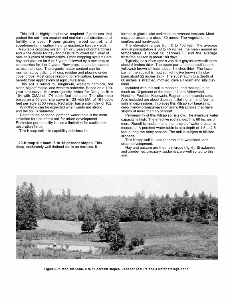
This soil is highly productive cropland if practices thatprotect the soil from erosion and maintain soil structure andfertility are used. Proper grazing, weed control, andsupplemental irrigation help to maximize forage yields.
A suitable cropping system is 5 or 6 years of orchardgrassand white clover for hay and pasture followed by 1 year ofoats or 3 years of strawberries. Other cropping systems arehay and pasture for 5 or 6 years followed by a row crop orcaneberries for 1 or 2 years. Row crops should be plantedacross the slope. The organic matter content can bemaintained by utilizing all crop residue and plowing undercover crops. Most crops respond to fertilization. Legumesbenefit from applications of agricultural lime.
This soil is suited to Douglas-fir, western hemlock, redalder, bigleaf maple, and western redcedar. Based on a 100-year site curve, the average site index for Douglas-fir is164 with CMAI of 174 cubic feet per acre. The site indexbased on a 50-year site curve is 123 with MAI of 161 cubicfeet per acre at 50 years. Red alder has a site index of 102.
Windthrow can be expected when winds are strongand the soil is saturated.
Depth to the seasonal perched water table is the mainlimitation for use of this soil for urban development.Restricted permeability is also a limitation for septic tankabsorption fields.
This Kitsap soil is in capability subclass Ile.
29-Kitsap silt loam, 8 to 15 percent slopes. Thisdeep, moderately well drained soil is on terraces. It
formed in glacial lake sediment on remnant terraces. Mostmapped areas are about 30 acres. The vegetation isconifers and hardwoods.
The elevation ranges from 0 to 400 feet. The averageannual precipitation is 30 to 45 inches, the mean annual airtemperature is about 50 degrees F, and the averagefrost-free season is about 180 days.
Typically, the surface layer is very dark grayish brown silt loamabout 5 inches thick. The upper part of the subsoil is darkyellowish brown silt loam about 8 inches thick. The lowerpart of the subsoil is mottled, light olive brown silty clayloam about 22 inches thick. The substratum to a depth of60 inches is stratified, mottled, olive silt loam and silty clayloam.
Included with this soil in mapping, and making up asmuch as 10 percent of the map unit, are Alderwood,Harstine, Poulsbo, Kapowsin, Ragnar, and Indianola soils.Also included are about 2 percent Bellingham and Normasoils in depressions. In places this Kitsap soil breaks intodeep, narrow drainageways containing Kitsap soils that haveslopes of more than 15 percent.
Permeability of this Kitsap soil is slow. The available watercapacity is high. The effective rooting depth is 60 inches ormore. Runoff is medium, and the hazard of water erosion ismoderate. A perched water table is at a depth of 1.5 to 2.5feet during the rainy season. The soil is subject to hillsideslippage.
This Kitsap soil is used for cropland, woodland, andurban development.
Hay and pasture are the main crops (fig. 6). Strawberriesand caneberries, principally raspberries, are well suited to thissoil.
Figure 6.-Kitsap silt loam, 8 to 15 percent slopes, used for pasture and a water storage pond.
This Kitsap soil is highly productive cropland if practices thatprotect the soil from erosion and maintain soil structure andfertility are used. Proper grazing, weed control, andsupplemental irrigation help to maximize forage yields.
A suitable cropping system is 5 or 6 years oforchardgrass and white clover for hay and pasturefollowed by 1 year of oats or 3 years of strawberries. Rowcrops should be planted across the slope. The organicmatter content can be maintained by utilizing all cropresidue and plowing under cover crops. Most crops respondto fertilization. Legumes benefit from applications ofagricultural lime.
This soil is suited to Douglas-fir, western hemlock, westernredcedar, bigleaf maple, and red alder. Based on a 100-yearsite curve, the average site index for Douglas-fir is 164with CMAI of 174 cubic feet per acre. The site index basedon a 50-year curve is 123 with MAI of 161 cubic feet peracre at 50 years. Red alder has a site index of 102.
Windthrow can be expected when winds are strongand the soil is saturated.
Slope and depth to the seasonal perched water table arethe main limitations for use of this soil for urbandevelopment. Restricted permeability is also a limitation forseptic tank absorption fields. Effluent from absorption fieldscan surface in downslope areas and create a hazard tohealth. A proper site preparation system is one that controlsrunoff, considers the slippage potential, and maintains theesthetic value. Springs or seeps are exposed on cut slopesduring road construction.
This Kitsap soil is in capability subclass Ille.
30-Kitsap silt loam, 15 to 30 percent slopes. Thisdeep, moderately well drained soil is on terraces. Itformed in glacial lake sediment on side slopes of terraces.Mapped areas are commonly less than 50 acres. Theaverage slope is about 18 to 20 percent. The vegetation isconifers and hardwoods.
The elevation ranges from 0 to 400 feet. The averageannual precipitation is 30 to 45 inches, the mean annual airtemperature is about 50 degrees F, and the averagefrost-free season is about 180 days.
Typically, the surface layer is very dark grayish brownsilt loam about 5 inches thick. The upper part of the subsoilis dark yellowish brown silt loam about 8 inches thick. Thelower part of the subsoil is mottled, light olive brown siltyclay loam about 22 inches thick. The substratum to a depthof 60 inches is stratified, mottled, olive silt loam and siltyclay loam.
Included with this soil in mapping are up to 10 percentAlderwood, Kapowsin, Harstine, and Poulsbo soils, and about 5percent Indianola and Ragnar soils. In places, sloping areashave developed from soil slumping under wet conditions.As a result of this soil movement, a clean vertical or nearlyvertical slope is exposed uphill.
Permeability of this Kitsap soil is slow. The availablewater capacity is high. The effective rooting depth is 60inches or more. Runoff is rapid, and the hazard of watererosion is severe. A perched water table is at a depth of 1.5to 2.5 feet during the rainy season. This soil is subject tohillside slippage.
This Kitsap soil is used mainly for woodland andhomesites.
This soil is suited to Douglas-fir, western hemlock,western redcedar, bigleaf maple, and red alder. Based on a100-year site curve, the average site index for Douglas-fir is164 with CMAI of 174 cubic feet per acre. The site indexbased on a 50-year site curve is 123 with MAI of 161 cubicfeet per acre at 50 years. Red alder has a site index of 102.
During logging, soil losses are minimized by specialerosion control practices and by exercising care in theselection of landings and skid trails. Springs and seeps arecommon on cut slopes. Some windthrow can be expectedwhen the winds are strong and the soil is saturated.
Slope and depth to the seasonal perched water table arethe main limitations for use of this soil for urbandevelopment. Restricted permeability is also a limitation forseptic tank absorption fields. Effluent from absorption fieldscan surface in downslope areas and create a hazard tohealth. In areas of moderate population density, the use ofonsite sewage disposal systems creates a definite healthhazard. A proper site preparation system is one thatcontrols runoff, considers the slippage potential, andmaintains the esthetic value. Springs or seeps are exposed,in places, during site preparation.
This Kitsap soil is in capability subclass IVe.
31-Kitsap silt loam, 30 to 45 percent slopes. Thisdeep, moderately well drained soil is on terraces. It formedin glacial lake sediment in steep-sided drainageways. Thevegetation is conifers and hardwoods.
The elevation ranges from 0 to 400 feet. The averageannual precipitation is 40 to 45 inches, the mean annual airtemperature is about 50 degrees F, and the average frost-free season is about 180 days.
Typically, the surface layer is very dark grayish brown siltloam about 5 inches thick. The upper part of the subsoil isdark yellowish brown silt loam about 8 inches thick. Thelower part of the subsoil is mottled, light olive brown siltyclay loam about 22 inches thick. The substratum to a depthof 60 inches is stratified, mottled, olive silt loam and siltyclay loam.
Included with this soil in mapping are up to 4 percentIndianola and Ragnar soils, and 3 percent Kitsap soilsthat have slopes of less than 30 percent. Verticalescarpments devoid of vegetation are also included.
Permeability of this Kitsap soil is slow. The availablewater capacity is high. The effective rooting depth is 60inches or more. Runoff is very rapid, and the hazard of watererosion is severe. A perched water table is at a depth of 1.5to 2.5 feet during the rainy season. This soil is subject tohillside slippage. Springs and seeps are common.
This Kitsap soil is used mainly for woodland.This soil is suited to Douglas-fir, western hemlock,
western redcedar, bigleaf maple, and red alder. Based on a100-year site curve, the average site index for Douglas-fir is164 with CMAI of 174 cubic feet per acre. The site indexbased on a 50-year site curve is 123 with MAI of 161 cubicfeet per acre at 50 years. Red alder has a site index of 102.
Some windthrow can be expected when the winds arestrong and the soil is saturated. Soil losses are minimized byshifting road building to more stable soils and by exercisingcare in the selection of landings and skid trails.
Slope and depth to the seasonal perched water table arethe main limitations for use of this soil for urbandevelopment. Slippage potential must be considered in sitepreparation. Restricted permeability is also a limitation forseptic tank absorption fields. Effluent from absorption fieldscan surface in downslope areas and create a hazard tohealth. Springs or seeps are exposed during sitepreparation. In most places, springs are used as domesticwater supply for beach homes.
This Kitsap soil is in capability subclass Vle.
32-McKenna gravelly loam. This moderately deepover compact glacial till, poorly drained soil formed inglacial till. It is on uplands in low lying depressions andalong drainageways. Native vegetation is hardwoods,conifers, sedges, and grasses. Slopes are 0 to 6 percent.
The elevation ranges from 50 to 500 feet. The averageannual precipitation is 35 to 50 inches, the mean annual airtemperature is about 50 degrees F, and the average frost-free season is about 170 days.
Typically, the surface layer is dark reddish brown gravellyloam about 6 inches thick. The subsoil is grayish brown verygravelly loam and very gravelly silt loam about 22 inchesthick. The upper part of the substratum is mottled grayishbrown very gravelly loam about 9 inches thick. The lowerpart of the substratum to a depth of 60 inches is mottled,compacted, gravelly silty clay glacial till. Depth to thecompact glacial till ranges from 30 to 40 inches.
Included with this soil in mapping are as much as 10percent Norma soils and 3 percent Kapowsin Variantsoils.
Permeability of this McKenna soil is slow to the compactglacial till and very slow in it. The available water capacity ismoderate. The effective rooting depth is limited by theseasonal perched water table and the depth to compactglacial till. Runoff is ponded during the winter months, andwater erosion is not a hazard.
This McKenna soil is used mainly for woodland,pasture, and wildlife habitat.
This McKenna soil is moderately productive for pasture ifpractices that maintain soil tilth and fertility are used.Artificial drainage can be provided by tile or open ditches ifoutlets are available. Weed control, proper grazing, andfertilization help to maximize forage yields.
The organic matter content can be maintained by utilizingall crop residue, plowing under cover crops, and using asuitable cropping system. Where the soil is drained, a typicalcropping system is a pasture of orchardgrass and whiteclover for 5 or 6 years followed by oats for 1 or 2 years. Apasture of meadow foxtail, timothy, big trefoil, and whiteclover is suitable for undrained areas. Most crops respond tonitrogen, phosphorus, and potassium. Legumes benefitfrom applications of agricultural lime.
The poor drainage limits the suitability of this soil to water-tolerant trees, such as red alder, western redcedar, andwestern hemlock. Based on a 50-year site curve, theaverage site index for red alder is 90 with CMAI of 101 cubicfeet per acre. The site index for western redcedar is 90.
The perched water table remains close to the surfacethroughout the rainy season. When winds are strong and thesoil is saturated, windthrow can be expected. Unless loggingroads constructed on this soil use extra roadfill and haveadequate drainage, movement of equipment is restricted tothe dry season.
Undrained areas of the McKenna soil provide ideal habitatfor such waterfowl as mallard, pintail, and wood ducks.Seeding of water-tolerant plants helps to improve the habitatfor wildlife.
This soil is poorly suited to homesites because of aperched water table and ponding during the rainy season.Restricted permeability is also a limitation for use of thissoil for septic tank absorption fields.
This McKenna soil is in capability subclass IVw.
33-Mukiiteo peat. This deep, very poorly drained soil ison long, narrow, backwater depressions of the major rivervalleys and upland depressional areas. It formed in organicmaterial mostly of partly decomposed plant remains. Theremains are mainly reeds, sedges, and water-tolerantshrubs and grasses. Slopes are 0 to 1 percent.
The elevation ranges from 0 to 300 feet. The averageannual precipitation is 40 to 70 inches, the mean annual airtemperature is about 50 degrees F, and the average frost-free season is about 170 days.
Typically, the surface layer is dark reddish brown peatabout 6 inches thick. The underlying material to a depth of60 inches is dark reddish brown peat.
Included with this soil in mapping are as much as 10percent Shalcar soils and about 2 percent Semiahmoosoils.
Permeability of this Mukilteo soil is moderate. Theavailable water capacity is high. The effective rooting
depth is limited by a high water table. Runoff is pondedduring the winter months, and water erosion is not ahazard or is a slight hazard.
This Mukilteo soil is used mainly for migratorywaterfowl habitat. A few areas are drained and usedmainly for pasture, hay, and silage.
This soil is productive as pasture and cropland only if dikesare constructed to control ponding, the water table islowered during the growing season by pumping, andproper management practices are used. Subsidence isminimized if the water table is maintained immediatelybelow the root zone and allowed to return to the surfaceduring the nongrowing season. Where the soil is drained, asuitable cropping system is a pasture of orchardgrass andwhite clover for 5 or 6 years followed by oats for 1 or 2 years;or continuous cropping with vegetables, including an annualwinter cover crop utilized as green manure. Most cropsrespond to nitrogen, phosphorus, and potassium. Legumesbenefit from applications of agricultural lime.
In undrained areas, this soil provides ideal habitat forwaterfowl, such as mallard, pintail, and wood ducks.Seeding of water-tolerant plants helps to improve thehabitat for wildlife.
This soil is poorly suited to homesites because of depthto the high water table, ponding, and subsidence. It isunable to support a load without settling. Onsite sewagedisposal systems function improperly or fail because ofthe high water table and ponding.
This Mukilteo soil is in capability subclass Ilw.
34-Neilton gravelly loamy sand, 0 to 3 percentslopes. This deep, excessively drained soil is onterraces, benches, and uplands. It formed in stratified, gravellyand sandy glacial outwash. Mapped areas are about 10 to 200acres. The vegetation is conifers.
The elevation ranges from 40 to 400 feet. The averageannual precipitation is 30 to 55 inches, the mean annual airtemperature is about 50 degrees F, and the average frost-free season is about 180 days.
Typically, the surface layer is dark brown gravelly loamy sandabout 4 inches thick. The subsoil is brown very gravellyloamy sand about 15 inches thick. The substratum to adepth of 60 inches is very gravelly sand.
Included with this soil in mapping are about 5 percentNeilton soils that have slopes of more than 3 percent, andabout 10 percent Indianola soils.
Permeability of this Neilton soil is rapid to a depth of 19inches and very rapid in the substratum. The available watercapacity is low. The effective rooting depth is 60 inches ormore. Runoff is very slow, and the hazard of water erosionis slight.
This Neilton soil is used for woodland and urbandevelopment. Some small areas are used for pasture.
This soil is suited to Douglas-fir. Based on a 100-yearsite curve, the average site index for Douglas-fir is 125
with CMAI of 122 cubic feet per acre. The site indexbased on a 50-year site curve is 95 with MAI of 108cubic feet per acre at 50 years.
Trees can be harvested throughout the year by usingproper equipment. This soil is capable of moderateproduction of floral greenery, such as salal, evergreenhuckleberry, and western swordfern. Douglas-fir responds tonitrogen fertilizer.
Proper grazing, weed control, and supplemental irrigation help to maximize forage yields for pasture.
This soil is well suited to urban development. Cutbanks may cave in excavations.
This Neilton soil is in capability subclass Vls.
35-Neilton gravelly loamy sand, 3 to 15 percentslopes. This deep, excessively drained soil is on terraces,benches, and uplands. It formed in stratified, gravelly andsandy glacial outwash. Mapped areas are about 5 to 100acres. The vegetation is conifers.
Elevation ranges from 50 to 400 feet. The averageannual precipitation is 30 to 55 inches, the mean annual airtemperature is about 50 degrees F, and the average frost-free season is about 180 days.
Typically, the surface layer is dark brown gravelly loamysand about 4 inches thick. The subsoil is brown verygravelly loamy sand about 15 inches thick. The substratumto a depth of 60 inches is very gravelly sand.
Included with this soil in mapping are about 5 percentNeilton soils that have slopes of more than 15 percent andabout 5 percent Indianola and Ragnar soils.
Permeability of this Neilton soil is rapid to a depth of 19inches and very rapid in the substratum. The availablewater capacity is low. The effective rooting depth is 60inches or more. Runoff is slow, and the hazard of watererosion is slight.
This Neilton soil is used for woodland and urbandevelopment (fig. 7). Some small areas are used forpasture.
This soil is suited to Douglas-fir. Based on a 100-yearsite curve, the average site index for Douglas-fir is 125with CMAI of 122 cubic feet per acre. The site index basedon a 50-year site curve is 95 with MAI of 108 cubic feetper acre at 50 years.
Trees may be harvested throughout the year by usingproper equipment. This soil is capable of moderateproduction of floral greenery, such as salal, evergreenhuckleberry, and western swordfern. Douglas-fir respondsto nitrogen fertilizer.
Proper grazing, weed control, and supplementalirrigation help to maximize forage yields for pasture. Alltillage operations in preparing seedbeds for pasture shouldbe across the slope or on the contour.
The main limitation for urban development is slope.Cutbanks may cave in excavations.
This Neilton soil is in capability subclass Vls.
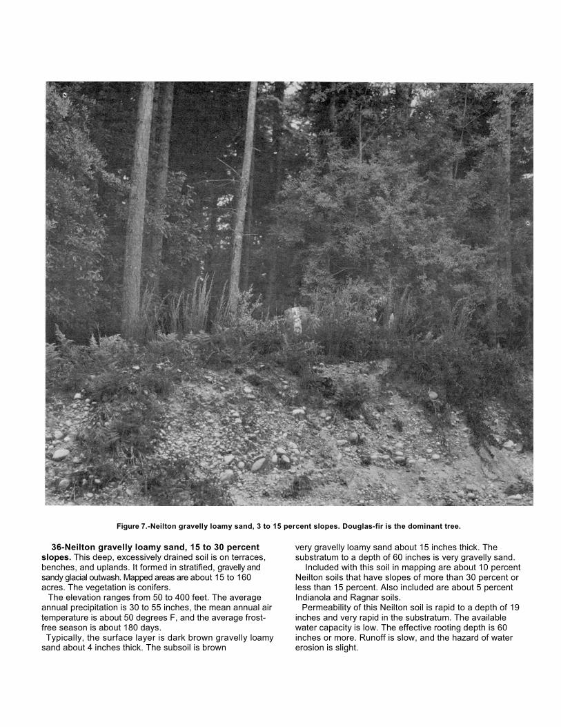
Figure 7.-Neilton gravelly loamy sand, 3 to 15 percent slopes. Douglas-fir is the dominant tree.
36-Neilton gravelly loamy sand, 15 to 30 percentslopes. This deep, excessively drained soil is on terraces,benches, and uplands. It formed in stratified, gravelly andsandy glacial outwash. Mapped areas are about 15 to 160acres. The vegetation is conifers.
The elevation ranges from 50 to 400 feet. The averageannual precipitation is 30 to 55 inches, the mean annual airtemperature is about 50 degrees F, and the average frost-free season is about 180 days.Typically, the surface layer is dark brown gravelly loamy
sand about 4 inches thick. The subsoil is brown
very gravelly loamy sand about 15 inches thick. Thesubstratum to a depth of 60 inches is very gravelly sand.
Included with this soil in mapping are about 10 percentNeilton soils that have slopes of more than 30 percent orless than 15 percent. Also included are about 5 percentIndianola and Ragnar soils.
Permeability of this Neilton soil is rapid to a depth of 19inches and very rapid in the substratum. The availablewater capacity is low. The effective rooting depth is 60inches or more. Runoff is slow, and the hazard of watererosion is slight.

This Neilton soil is used mainly for woodland. A fewareas are used for urban development.
This soil is suited to Douglas-fir. Based on a 100-yearsite curve, the average site index for Douglas-fir is 125with CMAI of 122 cubic feet per acre. The site index basedon a 50-year site curve is 95 with MAI of 108 cubic feet peracre at 50 years.
In places, trees are harvested throughout the year byusing proper equipment. This soil is capable ofmoderate production of floral greenery, such as salal,evergreen huckleberry, and western swordfern. Douglas-firresponds to nitrogen fertilizer.
The main limitation for urban development is slope. Inplaces, cutbanks cave in excavations. This Neilton soil isin capability subclass VIs.
37-Norma fine sandy loam. This deep, poorly drainedsoil is on long, narrow stream bottoms and on till plaindepressions in the uplands. It formed in mixed glacialalluvium. Slopes are mainly 0 to 3 percent. Nativevegetation is sedges, grasses, conifers, and hardwoods.
The elevation ranges from 0 to 300 feet. The averageannual precipitation is 35 to 60 inches, the mean annual airtemperature is about 50 degrees F, and the average frost-free season is about 170 days.
Typically, the surface layer is very dark grayish brown finesandy loam about 8 inches thick. The subsoil is distinctlymottled, light olive brown fine sandy loam about 14 inchesthick. The substratum to a depth of 60 inches is mottled,olive gray and dark yellowish brown stratified sandy loam, clayloam, and loamy sand.
Included with this soil in mapping, and making up about10 percent of the map unit, are Bellingham, McKenna,and Shalcar soils. Also included are small areas that havean organic surface layer as thick as 5 inches, and smallareas that have a sand substratum.
Permeability of this Norma soil is moderately rapid.The available water capacity is high. The effectiverooting depth is limited by a high water table. Runoff isponded, and the hazard of water erosion is slight. This soilis ponded during the winter months.
This Norma soil is used for woodland, pasture, andwildlife habitat.
This soil is moderately productive for pasture if practicesthat maintain tilth and fertility are used. Drainage can beprovided by tile or open ditch methods if outlets areavailable. Weed control, prevention of overgrazing, andfertilization help to maximize forage yields.
The organic matter content can be maintained by usingall crop residue, plowing under cover crops, and using asuitable cropping system. If the soil is artificially drained, atypical cropping system is pasture of orchardgrass andwhite clover for 5 or 6 years followed by oats for 1 or 2years. A pasture of meadow foxtail, timothy, alsike clover,and white clover is suitable for undrained areas. Most cropsrespond to nitrogen, phosphorus, and potassium.Legumes benefit from applications of agricultural lime.
This soil provides excellent habitat for such waterfowl asmallard, pintail, and wood ducks. Seeding of selected plantshelps to improve the wetland wildlife habitat.
This soil is suited to red alder, western redcedar, andwestern hemlock. Based on a 50-year site curve, theaverage site index for red alder is 90 with CMAI of 101 cubicfeet per acre.
Logging roads constructed on this soil require additionalballast and drainage; otherwise, the movement of equipmentis restricted to the dry season. Windthrow can be expectedwhen winds are strong and the soil is saturated.
This soil is poorly suited to homesites because of thedepth to the high water table and ponding. Onsite sewagedisposal systems do not function properly because of thewetness and ponding.
This Norma soil is in capability subclass IVw.
38-Pits. This miscellaneous area is open pits from whichgravel and sand have been excavated. The pits are 5 to 50acres. Most gravel pits are in areas of Kilchis, Schneider,Neilton, Grove, Indianola, and Ragnar soils, and a few are inAlderwood soils. The excavated gravelly material and somesandy material is used mainly for road construction and ballast.
39-Poulsbo gravelly sandy loam, 0 to 6 percentslopes. This moderately deep, moderately well drained soil ison broad uplands. It formed in glacial till. Most mapped areasare long and narrow and oriented north to south. Areasaverage about 100 acres. Native vegetation is conifers andhardwoods.
The elevation ranges from 0 to 450 feet. The averageannual precipitation is 30 to 40 inches, the mean annual airtemperature is about 51 degrees F, and the average frost-free season is about 210 days.
Typically, the surface of this soil is covered by a 2-inch matof undecomposed and partially decomposed needles, leaves,and wood fragments. The subsurface layer is dark grayishbrown gravelly sandy loam 2 inches thick. The subsoil isdark brown and dark yellowish brown gravelly sandy loam 22inches thick. The substratum is a weakly-silica-cementedhardpan about 4 inches thick over very compact, gravellysandy loam glacial till. Depth to the hardpan ranges from 20to 40 inches.
Included with this soil in mapping, and making up as muchas 10 percent of the map unit, are Ragnar soils and smallpockets of Sinclair soils. Also included is a soil similar to thisPoulsbo soil that has a compact sandy till layer at a depth ofabout 30 inches.
Permeability of this Poulsbo soil is moderately rapidabove the hardpan and very slow through the pan. Theavailable water capacity is low. The effective rooting depthranges from 20 to 40 inches. Runoff is slow, and thehazard of water erosion is slight. A perched water table isat a depth of 1 to 2.5 feet during the rainy season.
This Poulsbo soil is used mainly for woodland. Someareas are used for cropland, hay, pasture, and urbandevelopment.
Brush picking for floral arrangements is an importantminor industry.
This soil is suited to Douglas-fir. Based on a 100-yearsite curve, the average site index for Douglas-fir is 161with CMAI of 171 cubic feet per acre. The site index basedon a 50-year site curve is 121 with MAI of 158 cubic feetper acre at 50 years.
During periods of heavy rainfall, a perched water tableis at a shallow depth for a short time. Trees are subject towindthrow when winds are strong and the soil is saturated.Rooting depth is limited by the cemented pan.
Crop yields are moderate if practices that maintain soil tilthand fertility are used. Proper grazing practices, weedcontrol, and supplemental irrigation increase forage yields.
The organic matter content can be maintained by usingcrop residue, plowing under cover crops, and using asuitable cropping system. A suitable cropping system is apasture of orchardgrass and white clover for 5 or 6 yearsfollowed by oats for 1 year. Most crops respond to nitrogen,phosphorus, and potassium. Legumes benefit fromapplications of agricultural lime.
This soil is suited to urban development if communitysewage systems are built. Wetness and the cemented panare the main limitations. In areas of moderate and highpopulation density, onsite septic tank absorption systemsoften fail or do not function properly during periods of highrainfall because of wetness and depth to the pan.
This Poulsbo soil is in capability subclass lVw.
40-Poulsbo gravelly sandy loam, 6 to 15 percentslopes. This moderately deep, moderately well drained soil is onbroad uplands. It formed in glacial till. Most mapped areasare long and narrow and oriented north to south. Areasaverage about 80 acres. Native vegetation is conifers andhardwoods.
The elevation ranges from 0 to 450 feet. The averageannual precipitation is 30 to 40 inches, the mean annual airtemperature is about 51 degrees F, and the average frost-free season is about 210 days.
Typically, the surface of this soil is covered by a 2-inch matof undecomposed and partially decomposed needles, leaves,and wood fragments. The subsurface layer is dark grayishbrown gravelly sandy loam 2 inches thick. The subsoil isdark brown and dark yellowish brown gravelly sandy loam 22inches thick. The substratum is a weakly-silica-cementedhardpan about 4 inches thick over very compact gravellysandy loam glacial till. Depth to the hardpan ranges from 20to 40 inches.
Included with this soil in mapping are as much as 10percent Ragnar soils and about 5 percent Poulsbo soils thathave slopes of more than 15 percent or less than 6percent. Also included is a soil similar to this Poulsbo
soil that has a compact sandy till layer at a depth ofabout 30 inches.
Permeability of this Poulsbo soil is moderately rapidabove the hardpan and very slow through the pan. Theavailable water capacity is low. The effective rooting depthranges from 20 to 40 inches. Runoff is slow, and thehazard of water erosion is slight. A perched water table isat a depth of 1 to 2.5 feet during the rainy season.
This Poulsbo soil is used mainly for woodland. Smallareas are used for cropland, hay, pasture, and urbandevelopment.
Brush picking for floral arrangements is an importantminor industry.
This soil is suited to Douglas-fir. Based on a 100-yearsite curve, the average site index for Douglas-fir is 161 withCMAI of 171 cubic feet per acre. The site index based on a50-year site curve is 121 with MAI of 158 cubic feet peracre at 50 years.
During periods of heavy rainfall, a perched water table isat a shallow depth for a short time. Trees are subject towindthrow when winds are strong and the soil is saturated.Rooting depth is limited by the cemented pan.
Crop yields are moderate if practices that maintain soiltilth and fertility are used. All tillage operations should beacross the slope or on the contour. Proper grazingpractices, weed control, and supplemental irrigation increaseforage yields.
The organic matter content can be maintained by usingcrop residue, plowing under cover crops, and using asuitable cropping system. A suitable cropping system ispasture of orchardgrass and white clover for 5 or 6 yearsfollowed by oats for 1 year. Most crops respond to nitrogen,phosphorus, and potassium. Legumes benefit fromapplications of agricultural lime.
This soil is suited to urban development if communitysewage systems are built. Slope, wetness, and thecemented pan are the main limitations. In areas of moderateand high population density, onsite septic tank absorptionsystems often fail or do not function properly during periodsof high rainfall because of wetness and depth to the pan.
This Poulsbo soil is in capability subclass IVe.
41-Poulsbo gravelly sandy loam, 15 to 30 percentslopes. This moderately deep, moderately well drained soilis on broad uplands. It formed in glacial till. Most mappedareas are long and narrow and oriented north tosouth. Areas average about 50 acres. Native vegetation isconifers and hardwoods.
The elevation ranges from 0 to 450 feet. The averageannual precipitation is 30 to 40 inches, the mean annual airtemperature is about 51 degrees F, and the average frost-free season is about 210 days.
Typically, the surface of this soil is covered by a 2-inchmat of undecomposed and partially decomposed needles,leaves, and wood fragments. The subsurface layer is darkgrayish brown gravelly sandy loam 2 inches
thick. The subsoil is dark brown and dark yellowish browngravelly sandy loam 22 inches thick. The substratum is aweakly-silica-cemented hardpan about 4 inches thick oververy compact, gravelly sandy loam glacial till. Depth to thehardpan ranges from 20 to 40 inches.
Included with this soil in mapping are as much as 10percent Ragnar soils, and about 5 percent Poulsbo soils thathave slopes of more than 30 percent or less than 15percent. Also included is a soil similar to this Poulsbo soilthat has a compact sandy till layer at a depth of about 30inches.
Permeability of this Poulsbo soil is moderately rapidabove the hardpan and very slow through the pan. Theavailable water capacity is low. The effective rooting depthranges from 20 to 40 inches. Runoff is medium, and thehazard of water erosion is moderate. A perched water tableis at a depth of 1 to 2.5 feet during the rainy season.
This Poulsbo soil is used mainly for woodland. Smallareas are used for cropland, hay, pasture, and urbandevelopment.
Brush picking for floral arrangements is an importantminor industry.
This soil is suited to Douglas-fir. Based on a 100-year sitecurve, the average site index for Douglas-fir is 161 withCMAI of 171 cubic feet per acre. The site index based on a50-year site curve is 121 with MAI of 158 cubic feet peracre at 50 years.
During periods of heavy rainfall, a perched water tableis at a shallow depth for a short time. Trees are subject towindthrow when winds are strong and the soil is saturated.Rooting depth is limited by the cemented pan.
Crop yields are moderate if practices that maintain soil tilthand fertility are used. All tillage operations should be acrossthe slope or on the contour. Proper grazing practices, weedcontrol, and supplemental irrigation increase forage yields.
The organic matter content can be maintained by usingcrop residue, plowing under cover crops, and using a suitablecropping system. A suitable cropping system is a pastureof orchardgrass and white clover for 5 or 6 years followed byoats for 1 year. Most crops respond to nitrogen,phosphorus, and potassium. Legumes benefit fromapplications of agricultural lime.
This soil is poorly suited to urban developmentbecause of slope, wetness, and depth to the pan. Inareas of moderate and high population density, onsitesewage disposal systems often fail or do not functionproperly during periods of high rainfall because ofwetness and the depth to the pan.
This Poulsbo soil is in capability subclass IVe.
42-Poulsbo-Ragnar complex, 0 to 6 percent slopes.The soils of this complex are on broad uplands andterraces. They formed in glacial till and glacial outwash.Native vegetation is a mixed stand of conifers andhardwoods.
The elevation ranges from 0 to about 400 feet. Theaverage annual precipitation is 30 to 40 inches, the meanannual air temperature is about 50 degrees F, and theaverage frost-free season is about 190 days.
This complex is about 40 percent Poulsbo gravelly sandyloam, 0 to 6 percent slopes, and about 30 percent Ragnarfine sandy loam, 0 to 6 percent slopes. The soils of thiscomplex are so intricately intermingled that it was notpractical to map them separately at the scale used.
Included with these soils in mapping, and making upabout 30 percent of the complex, is a soil similar to thePoulsbo soil that has a compact sandy till layer at a depthof about 30 inches. Small areas of soils that have slopes ofmore than 6 percent are also included in this complex.
The Poulsbo soil is moderately deep and moderately welldrained. It formed in glacial till. Typically, the surface of thesoil is covered by a 2-inch mat of undecomposed andpartially decomposed needles, leaves, and wood fragments.The subsurface layer is dark grayish brown gravelly sandyloam 2 inches thick. The subsoil is dark brown and darkyellowish brown gravelly sandy loam 22 inches thick. Thesubstratum is a weakly-silica-cemented hardpan about 4inches thick over very compact, gravelly sandy loam glacialtill. Depth to the hardpan ranges from 20 to 40 inches.
Permeability of this Poulsbo soil is moderately rapidabove the hardpan and very slow through the pan. Theavailable water capacity is low. The effective rooting depthranges from 20 to 40 inches. Runoff is slow, and thehazard of water erosion is slight. A perched water table isat a depth of 1 to 2.5 feet during the rainy season.
The Ragnar soil is deep and well drained. It formed onglacial outwash terraces. Typically, the soil has a surfacelayer of dark brown fine sandy loam 4 inches thick. Thesubsoil is dark yellowish brown fine sandy loam about 17inches thick. The substratum to a depth of 60 inches isgrayish brown and light brownish gray loamy sand.
Permeability of this Ragnar soil is moderately rapid.The available water capacity is moderate. The effectiverooting depth is 60 inches or more. Runoff is slow, and thehazard of water erosion is moderate.
The soils of this complex are used mainly for woodland.A few small areas are used for pasture, hay, cropland, andhomesites.
Brush picking for floral arrangements is an importantminor industry.
The Poulsbo soil is suited to Douglas-fir. Based on a100-year site curve, the average site index for Douglas-firis 161 with CMAI of 171 cubic feet per acre. The site indexbased on a 50-year site curve is 121 with MAI of 158 cubicfeet per acre at 50 years.
During periods of heavy rainfall, a perched water table isat a shallow depth in this Poulsbo soil for a short time. Treesare subject to windthrow when winds are strong and the soilis saturated. Rooting depth is limited by the cemented pan.

The Ragnar soil is well suited to Douglas-fir, westernhemlock, and red alder. Based on a 100-year site curve,the average site index for Douglas-fir is 167 with CMAI of178 cubic feet per acre. The site index based on a 50-yearsite curve is 125 with MAI of 165 cubic feet per acre at 50years.
This Ragnar soil is capable of producing moderateamounts of floral greenery, such as salal, evergreenhuckleberry, and western swordfern.
Crop yields are moderate if practices that maintain soiltilth and fertility are used. Proper grazing practices, weed control,and supplemental irrigation increase forage yields.
The organic matter content can be maintained by usingcrop residue, plowing under cover crops, and using a suitablecropping system. A suitable cropping system is a pasture oforchardgrass and white clover for 5 or 6 years followed byoats for 1 year. Most crops respond to nitrogen, phosphorus,and potassium. Legumes benefit from applications of agriculturallime.
The main limitations of the Poulsbo soil for homesites arethe depth to the cemented pan and wetness. Septic tankabsorption fields may not function properly during periodsof high rainfall because of wetness and depth to the pan.The Ragnar soil is well suited to urban development, butcutbanks may cave.
The soils of this complex are in capability subclass IVw.
43-Poulsbo-Ragnar complex, 6 to 15 percent slopes.The soils of this complex are on broad uplands. Theyformed in glacial till and glacial outwash. Native vegetationis a mixed stand of conifers and hardwoods.
The elevation ranges from 0 to about 400 feet. Theaverage annual precipitation is 30 to 40 inches, the meanannual air temperature is about 50 degrees F, and theaverage frost-free season is about 190 days.
This complex is about 40 percent Poulsbo gravellysandy loam, 6 to 15 percent slopes, and about 30 percentRagnar fine sandy loam, 6 to 15 percent slopes. The soilsof this complex are so intricately intermingled that it was notpractical to map them separately at the scale used.
Included with these soils in mapping, and making upabout 30 percent of the complex, is a soil similar toPoulsbo soil that has a compact sandy till layer at a depthof about 30 inches. Small areas of soils that have slopes ofmore than 15 percent are also included in this complex.
The Poulsbo soil is moderately deep and moderatelywell drained. It formed in glacial till. Typically, the surface ofthe soil is covered by a 2-inch mat of undecomposed andpartially decomposed needles, leaves, and wood fragments.The subsurface layer is dark grayish brown gravelly sandy loam2 inches thick. The subsoil is dark brown and darkyellowish brown gravelly sandy loam 22 inches thick. Thesubstratum is a weakly-silica-cemented hardpan about 4inches thick over very compact, gravelly
sandy loam glacial till. Depth to the hardpan ranges from 20to 40 inches.
Permeability of this Poulsbo soil is moderately rapidabove the hardpan and very slow through the pan. Theavailable water capacity is low. The effective rooting depthranges from 20 to 40 inches. Runoff is slow, and thehazard of water erosion is slight. A perched water table isat a depth of 1 to 2.5 feet during the rainy season.
The Ragnar soil is deep and well drained. It formed onglacial outwash terraces. Typically, the Ragnar soil has asurface layer of dark brown fine sandy loam 4 inches thick.The subsoil is dark yellowish brown fine sandy loam about17 inches thick. The substratum to a depth of 60 inches isgrayish brown and light brownish gray loamy sand.
Permeability of this Ragnar soil is moderately rapid.The available water capacity is moderate. The effectiverooting depth is 60 inches or more. Runoff is medium, andthe hazard of water erosion is severe.
The soils of this complex are used mainly for woodland.Small areas are used for pasture, hay, cropland, andhomesites. Brush picking for floral arrangements is animportant minor industry.
The Poulsbo soil is suited to Douglas-fir. Based on a 100-year site curve, the average site index for Douglas-fir is 161with CMAI of 171 cubic feet per acre. The site index basedon a 50-year site curve is 121 with MAI of 158 cubic feet peracre at 50 years. During periods of heavy rainfall, a perchedwater table is at a shallow depth for a short time. Trees aresubject to windthrow when winds are strong and the soil issaturated. Rooting depth is limited by the cemented pan.
This Ragnar soil is well suited to Douglas-fir, westernhemlock, and red alder. Based on a 100-year site curve, theaverage site index for Douglas-fir is 167 with CMAI of 178cubic feet per acre. Based on a 50-year site curve, theaverage site index is 125 with MAI of 165 cubic feet per acreat 50 years.
Crop yields are moderate if practices that maintain soil tilthand fertility are used. All tillage operations should be on thecontour or across the slope. Proper grazing practices, weedcontrol, and supplemental irrigation increase forage yields.
The organic matter content can be maintained by usingall crop residue, plowing under cover crops, and using asuitable cropping system. A suitable cropping system is apasture of orchardgrass and white clover for 5 or 6 yearsfollowed by oats for 1 year. Most crops respond to nitrogen,phosphorus, and potassium. Legumes benefit fromapplications of agricultural lime.
The main limitation of the Poulsbo and Ragnar soils forhomesites is slope. Depth to the cemented pan andwetness are limitations of the Poulsbo soil. Excavation islimited by the cemented pan. Septic tank absorption fieldsmay not function properly during periods of high rainfallbecause of wetness and depth to the pan. The Ragnar soilis well suited to urban development, but cutbanks may cave.

The soils of this complex are in capability subclassIVe.
44-Ragnar fine sandy loam, 0 to 6 percent slopes.This deep, well drained soil is on terraces and uplands. Itformed in glacial outwash. Native vegetation is conifers andhardwoods.
The elevation ranges from 0 to 500 feet. The averageannual precipitation is 35 to 65 inches, the mean annual airtemperature is about 50 degrees F, and the average frost-free season is about 180 days.
Typically, the surface layer is dark brown fine sandyloam 4 inches thick. The subsoil is dark yellowish brownfine sandy loam about 17 inches thick. The substratum to adepth of 60 inches is grayish brown and light brownish grayloamy sand.
Included with this soil in mapping are as much as 8percent Poulsbo and Indianola soils, and about 6 percentRagnar soils that have slopes of more than 6 percent.
Permeability of this Ragnar soil is moderately rapid.The available water capacity is moderate. The effectiverooting depth is 60 inches or more. Runoff is slow, and thehazard of water erosion is moderate.
This Ragnar soil is used mainly for woodland and urbanland. Some areas are used for hay, pasture, andcropland.
This soil is suited to Douglas-fir, western hemlock, andred alder. Based on a 100-year site curve, the average siteindex for Douglas-fir is 167 with CMAI of 178 cubic feet peracre. The site index based on a 50-year site curve is 125with MAI of 165 cubic feet per acre at 50 years.
This Ragnar soil is moderately productive cropland ifpractices that maintain soil tilth and fertility are used. Weedcontrol, proper grazing, and fertilization help to maximizeforage yields.
The organic matter content can be maintained by utilizingcrop residue, plowing under cover crops, and using asuitable cropping system. A suitable cropping system ispasture of orchardgrass and white clover for 5 or 6 yearsfollowed by oats for 1 year or strawberries for 3 years. Mostcrops respond to nitrogen, phosphorus, and potassium.Legumes benefit from applications of agricultural lime.
This soil is well suited to urban development.Cutbanks may cave in excavations.
This Ragnar soil is in capability subclass IVs.
45-Ragnar fine sandy loam, 6 to 15 percent slopes.This deep, well drained soil is on terraces and uplands. Itformed in glacial outwash. Native vegetation is conifers andhardwoods.
The elevation ranges from 0 to 500 feet. The averageannual precipitation is 35 to 65 inches, the mean annual airtemperature is about 50 degrees F, and the average frost-free season is about 180 days.
Typically, the surface layer is dark brown fine sandyloam 4 inches thick. The subsoil is dark yellowish brown
fine sandy loam about 17 inches thick. The substratum to adepth of 60 inches is grayish brown and light brownish grayloamy sand.
Included with this soil in mapping are as much as 10percent Poulsbo and Indianola soils, and about 5 percentRagnar soils that have slopes of more than 15 percent orless than 6 percent.
Permeability of this Ragnar soil is moderately rapid.The available water capacity is moderate. The effectiverooting depth is 60 inches or more. Runoff is medium, andthe hazard of water erosion is severe.
This Ragnar soil is used mainly for woodland. Someareas are used for hay, pasture, cropland, and homesites.
This soil is suited to Douglas-fir, western hemlock, and redalder. Based on a 100-year site curve, the average site indexfor Douglas-fir is 167 with CMAI of 178 cubic feet per acre.The site index based on a 50-year site curve is 125 with MAIof 165 cubic feet per acre at 50 years.
This Ragnar soil is moderately productive cropland ifpractices that maintain soil tilth and fertility are used.Weed control, proper grazing, and fertilizer help tomaximize forage yields.
The organic matter content can be maintained by utilizingall crop residue, plowing under cover crops, and usingsuitable cropping systems. All tillage operations should be onthe contour or across the slope. A suitable cropping systemis a pasture of orchardgrass and white clover for 5 or 6years followed by oats for 1 year or strawberries for 3 years.Most crops respond to nitrogen, phosphorus, and potassium.Legumes benefit from applications of agricultural lime.
The main limitation for use of this soil for urbandevelopment is slope. Cutbanks may cave inexcavations.
This Ragnar soil is in capability subclass IVe.
46-Ragnar fine sandy loam, 15 to 30 percentslopes. This deep, well drained soil is on terraces anduplands. It formed in glacial outwash. Native vegetation isconifers and hardwoods.
The elevation ranges from 0 to 500 feet. The averageannual precipitation is 35 to 65 inches, the mean annual airtemperature is about 50 degrees F, and the average frost-free season is about 180 days.
Typically, the surface layer is dark brown fine sandy loam4 inches thick. The subsoil is dark yellowish brown finesandy loam about 17 inches thick. The substratum to adepth of 60 inches is grayish brown and light brownish grayloamy sand.
Included with this soil in mapping are as much as 10percent Poulsbo and Indianola soils, and about 5 percentRagnar soils that have slopes of more than 30 percent androlling slopes of less than 15 percent.
Permeability of this Ragnar soil is moderately rapid. Theavailable water capacity is moderate. The effective rootingdepth is 60 inches or more. Runoff is medium, and thehazard of water erosion is severe.
This Ragnar soil is used mainly for woodland. Some areasare used for urban development.
This soil is suited to Douglas-fir, western hemlock, andred alder. Based on a 100-year site curve, the averagesite index for Douglas-fir is 139 with CMAI of 144 cubicfeet per acre. The site index based on a 50-year site curve is105 with MAI of 127 cubic feet per acre at 50 years.
The main limitation for urban development on this soil isslope. Deep cuts made during road construction exposeunstable soil material. Cutbanks may cave. A site preparationsystem that controls runoff and maintains the estheticvalue is needed.
This Ragnar soil is in capability subclass IVe.
47-Ragnar-Poulsbo complex, 15 to 30 percentslopes. The soils of this complex are on broad uplands.They formed in glacial till and glacial outwash. Nativevegetation is a mixed stand of conifers and hardwoods.
The elevation ranges from 0 to about 400 feet. Theaverage annual precipitation is 25 to 40 inches, the meanannual air temperature is about 50 degrees F, and theaverage frost-free season is about 190 days.
This complex is about 45 percent Ragnar fine sandyloam, 15 to 30 percent slopes, and about 30 percentPoulsbo gravelly sandy loam, 15 to 30 percent slopes.The soils of this complex are so intricately intermingled that itwas not practical to map them separately at the scale used.
Included with this complex is about 25 percent of a soilsimilar to the Poulsbo soil that has a compact sandy till layerat a depth of about 30 inches. Small areas of soils that haveslopes of more than 30 percent are also included.
The Ragnar soil is deep and well drained. It formed inglacial outwash. Typically, the soil has a surface layer of darkbrown fine sandy loam 4 inches thick. The subsoil is darkyellowish brown fine sandy loam about 17 inches thick. Thesubstratum to a depth of 60 inches or more is grayish brownand light brownish gray loamy sand.
Permeability of this Ragnar soil is moderately rapid. Theavailable water capacity is moderate. The effective rootingdepth is 60 inches or more. Runoff is medium, and thehazard of water erosion is severe.
The Poulsbo soil is moderately deep and moderately welldrained. It formed in glacial till. Typically, the surface of thissoil is covered by a 2-inch mat of undecomposed andpartially decomposed needles, leaves, and wood fragments.The subsurface layer is dark grayish brown gravelly sandy loam2 inches thick. The subsoil is dark brown and darkyellowish brown gravelly sandy loam 22 inches thick. Thesubstratum is a weakly-silica-cemented hardpan about 4 inchesthick over very compact, gravelly sandy loam glacial till.Depth to the hardpan ranges from 20 to 40 inches.
Permeability of this Poulsbo soil is moderately rapidabove the hardpan and very slow through the hardpan. Theavailable water capacity is low. The effective rooting
depth ranges from 20 to 40 inches. Runoff is medium, andthe hazard of water erosion is severe. A perched water tableis at a depth of 1 to 2.5 feet during the rainy season.
The soils of this complex are used mainly forwoodland.
This Ragnar soil is suited to Douglas-fir, western hemlock,and red alder. Based on a 100-year site curve, the averagesite index for Douglas-fir is 139 with CMAI of 144 cubic feetper acre. The site index based on a 50-year site curve is 105with MAI of 127 cubic feet per acre at 50 years.
Based on a 100-year site curve for Poulsbo soil, theaverage site index for Douglas-fir is 161 with CMAI of 171cubic feet per acre. Based on a 50-year site curve, theaverage site index is 121 with MAI of 158 cubic feet peracre at 50 years.
Windthrow can be expected when winds are strong andthe soil is saturated.
The soils in this complex are in capability subclassIVe.
48-Schneider very gravelly loam, 45 to 70 percentslopes. This deep, well drained soil is on uplands. It formedin colluvium from basalt. Native vegetation is conifers andshrubs.
The elevation ranges from 100 to 1,500 feet. Theaverage annual precipitation is 60 to 75 inches, the meanannual air temperature is about 49 degrees F, and theaverage frost-free season is about 170 days.
Typically, the upper part of the surface layer is darkreddish brown very gravelly loam about 6 inches thick. Thelower part of the surface layer is dark reddish brownextremely gravelly loam about 17 inches thick. The subsoil isdark brown extremely gravelly silt loam about 25 inches thickover basalt. Depth to the basalt is 40 inches or more.
Included with this soil in mapping, and making up about10 percent of the map unit, are Kilchis soils on rockyknolls. Also included are small areas that have slopes ofless than 30 percent or more than 70 percent. There aresmall inclusions of Shelton soils at lower elevation.
Permeability of this Schneider soil is moderate. Theavailable water capacity is moderate. The effective rootingdepth is 40 inches or more. Runoff is rapid, and the hazardof water erosion is severe.
This soil is used mainly for woodland, recreation,watershed, and wildlife habitat. Recreation is limited tohiking and hunting.
This soil is suited to Douglas-fir. Based on a 100-year sitecurve, the average site index for Douglas-fir is 151 withCMAI of 159 cubic feet per acre. The site index based on a50-year site curve is 115 with MAI of 146 cubic feet peracre at 50 years.
Because this very steep colluvial soil is unstable, specialcare is needed in logging and road construction.
This Schneider soil is in capability subclass VIle.
49-Semiahmoo muck. This deep, very poorly drained soilis in depressional backwater areas of flood plains. It formedin decaying organic material. Slopes are 0 to 1 percent. Thenative vegetation is mainly sedges, reeds, and water-tolerantshrubs and grasses.
The elevation ranges from 0 to 200 feet. The averageannual precipitation is 35 to 50 inches, the mean annual airtemperature is about 49 degrees F, and the average frost-free season is about 180 days.
Typically, the surface layer is black muck 8 inches thick.The underlying material to a depth of 66 inches is blackmuck.
Included with this soil in mapping are as much as 10percent Shalcar soil and about 5 percent Mukilteo soil.Also included are areas that have thin lenses ofdiatomaceous earth and volcanic ash in the subsoil.
Permeability of this Semiahmoo soil is moderately slow.The available water capacity is high. The effective rootingdepth is limited by the high water table. Runoff is ponded,and water erosion is not a hazard. This soil is subject toponding during the winter months.
This Semiahmoo soil is used mainly for pasture. Withthe construction of dikes to control ponding, pumping tolower the water table during the growing season, and goodmanagement, this soil is very productive. Practices thatmaintain tilth and fertility are necessary. Drainage can beprovided by tile or open ditch methods if outlets areavailable. Weed control, prevention of overgrazing, andfertilizer help to maximize forage yields.
Subsidence is minimized if the water table ismaintained immediately below the root zone and allowed toreturn to the surface during the nongrowing season. Whenthe soil is drained, a suitable cropping system is pasture oforchardgrass and white clover for 5 or 6 years followed byoats for 1 or 2 years. Most crops respond to nitrogen,phosphorus, and potassium. Legumes benefit fromapplications of agricultural lime.
In undrained areas, this soil provides excellent habitat forwaterfowl, such as mallard, pintail, and wood ducks.Seeding of water-tolerant plants helps to improve thehabitat for wildlife.
This soil is poorly suited to homesites because of depth tothe high water table, ponding, and subsidence. It is not ableto support a load without settling. Onsite sewage disposalsystems function improperly or fail because of the highwater table, ponding, and restricted permeability.
This Semiahmoo soil is in capability subclass Ilw.
50-Shalcar muck. This deep, very poorly drained soil ison backwater depressions in valley and uplands. It formed indecaying organic material over alluvium. Slopes are 0 to 1percent. The native vegetation is mainly reeds, sedges, andwater-tolerant shrubs and grasses.
The elevation ranges from 0 to 400 feet. The averageannual precipitation is 35 to 60 inches, mean annual airtemperature is about 49 degrees F, and the average frost-free season is about 180 days.
Typically, the surface layer is very dark brown muck about32 inches thick. The underlying material to a depth of 60inches is grayish brown stratified silt loam, silty clay loam,sandy loam, and loamy sand.
Included with this soil in mapping are about 10 percentSemiahmoo soil and about 5 percent Norma soil.
Permeability of this Shalcar soil is moderately slow. Theavailable water capacity is high. The effective rooting depthis limited by a high water table. Runoff is ponded, andwater erosion is not a hazard or is a slight hazard. This soilis subject to ponding during the winter months.
This Shalcar soil is used mainly for migratory waterfowlhabitat and for pasture. With construction of dikes to controlponding, pumping to lower the water table during the growingseason, and good management, this soil is very productive.Practices that maintain tilth and fertility are necessary.Drainage can be provided by tile or open ditch methods ifoutlets are available. Weed control, prevention ofovergrazing, and fertilization help to maximize forage yields.
Subsidence is minimized if the water table is maintainedimmediately below the root zone and allowed to return to thesurface during the nongrowing season.
In undrained areas, this soil provides excellent habitat forwaterfowl, such as mallard, pintail, and wood ducks.Seeding of water-tolerant plants helps to improve the habitatfor wildlife.
This soil is poorly suited to homesites because of depthto the high water table, ponding, and subsidence. The soil isunable to support a load without settling. Onsite sewagedisposal systems function improperly or fail because of thehigh water table, ponding, and restricted permeability.
This Shalcar soil is in capability subclass Ilw.
51-Shelton very gravelly sandy loam, 0 to 6 percentslopes. This moderately deep, moderately well drained soilis on moraines and till plains. It formed in glacial till.Mapped areas average 65 acres and are long and narrowand oriented north to south. The vegetation is conifers.
The elevation ranges from 100 to 800 feet. The averageannual precipitation is 50 to 70 inches, the mean annual airtemperature is about 49 degrees F, and the average frost-free season is about 170 days.
Typically, the surface of this soil is covered by a thin matof undecomposed needles and wood fragments. The subsoilis dark reddish brown and dark brown very gravelly sandyloam about 25 inches thick. The substratum is weakly-silica-cemented, very compact glacial till to a depth of 60 inchesor more. Depth to the hardpan ranges from 20 to 35 inches.
Included with this soil in mapping are about 10 percentShelton extremely gravelly sandy loam and about 5 percentMcKenna soils in small potholes. Also included in thewestern part of the county are small areas where thecemented pan overlies gravelly and sandy glacial outwash.

Permeability of this Shelton soil is rapid to the cementedpan and very slow in the pan. The available water capacity islow. The effective rooting depth is 20 to 35 inches. Runoff isslow, and the hazard of water erosion is slight. A perchedwater table is at a depth of 2 to 3 feet during the rainyseason.
This Shelton soil is used mainly for woodland andhomesites. Some small areas are used for pasture.
The picking of evergreen huckleberry, western swordfern, andsalal is an important minor industry.
This soil is well suited to Douglas-fir and Christmas trees.The major trees are Douglas-fir and western hemlock. Treesmay be pale unless nitrogen fertilizer is added.
Based on a 100-year site curve, the average site index forDouglas-fir is 141 with CMAI of 146 cubic feet per acre. Thesite index based on a 50-year site curve is 107 with MAI of130 cubic feet per acre at 50 years.
Douglas-fir responds to nitrogen fertilizer. Somewindthrow can be expected when winds are strong andthe soil is saturated.
Weed control, proper grazing, and fertilization help to maximizeforage yields for pasture.
The main limitation for use of this soil for homesites iswetness. The cemented pan and wetness are the mainlimitations for septic tank absorption fields.
This Shelton soil is in capability subclass IVw.
52-Shelton very gravelly sandy loam, 6 to 15 percentslopes. This moderately deep, moderately well drained soil is onmoraines and till plains. It formed in glacial till. Mappedareas average 65 acres and are long and narrow andoriented north to south. The vegetation is conifers.
The elevation ranges from 100 to 800 feet. The averageannual precipitation is 50 to 70 inches, the mean annual airtemperature is about 49 degrees F, and the average frost-freeseason is about 170 days.
Typically, the surface of this soil is covered by a thin matof undecomposed needles and wood fragments. Thesubsoil is dark reddish brown and dark brown very gravellysandy loam about 25 inches thick. The substratum is weakly-silica-cemented, very compact glacial till to a depth of 60inches or more. Depth to the hardpan ranges from 20 to 35inches.
Included with this soil in mapping are about 10 percentShelton extremely gravelly sandy loam and about 5percent McKenna soils in small potholes. Also included inthe western part of the county are small areas where thecemented pan overlies gravelly and sandy glacial outwash.
Permeability of this Shelton soil is rapid to the cementedpan and very slow in the pan. The available water capacityis low. The effective rooting depth is 20 to 35 inches. Runoffis slow, and the hazard of water erosion is slight. A perchedwater table is at a depth of 2 to 3 feet during the rainyseason.
This Shelton soil is used mainly for woodland andhomesites. Small areas are used for pasture.
The picking of evergreen huckleberry, western swordfern,and salal is an important minor industry.
This soil is well suited to Douglas-fir and Christmas trees.The major trees are Douglas-fir and western hemlock. Treesmay be pale unless nitrogen fertilizer is added. Windthrowcan be expected when winds are strong and the soil issaturated.
Based on a 100-year site curve, the average site index forDouglas-fir is 141 with CMAI of 146 cubic feet per acre. Thesite index based on a 50-year site curve is 107 with MAI of130 cubic feet per acre at 50 years.
Weed control, proper grazing, and fertilization help tomaximize forage yields for pasture.
The main limitations for use of this soil for homesites areslope and wetness. The cemented pan, slope, and wetnessare the main limitations for septic tank absorption fields.
This Shelton soil is in capability subclass IVe.
53-Shelton very gravelly sandy loam, 15 to 30percent slopes. This moderately deep, moderately welldrained soil is on moraines and till plains. It formed in glacialtill. Mapped areas average 50 acres and are long and narrowand oriented north to south. The vegetation is conifers.
The elevation ranges from 100 to 800 feet. The averageannual precipitation is 50 to 70 inches, the mean annual airtemperature is about 49 degrees F, and the average frost-free season is about 170 days.
Typically, the surface of this soil is covered by a thin matof undecomposed needles and wood fragments. Thesubsoil is dark reddish brown and dark brown very gravellysandy loam about 25 inches thick, The substratum isweakly-silica-cemented, very compact glacial till to a depthof 60 inches or more. Depth to the hardpan ranges from 20to 35 inches.
Included with this soil in mapping are about 5 percentShelton extremely gravelly sandy loam and about 5 percentShelton soils that have slopes of more than 30 percent orless than 15 percent. Also included are small areas of soilsthat have a substratum of glacial outwash gravel and sand.
Permeability of this Shelton soil is rapid to the cementedpan and very slow in the pan. The available water capacity islow. The effective rooting depth is 20 to 35 inches. Runoff ismedium, and the hazard of water erosion is moderate. Aperched water table is at a depth of 2 to 3 feet during therainy season.
This Shelton soil is used mainly for woodland, pasture, andhomesites.
The picking of evergreen huckleberry, western swordfern,and salal is an important minor industry.
This soil is well suited to Douglas-fir and Christmas trees.The major trees are Douglas-fir and western hemlock. Treesmay be pale unless nitrogen fertilizer is added. Windthrowcan be expected when winds are strong and the soil issaturated.
Based on a 100-year site curve, the average site index forDouglas-fir is 141 with CMAI of 146 cubic feet per

acre. The site index based on a 50-year site curve is 107with MAI of 130 cubic feet per acre at 50 years.
Weed control, proper grazing, and fertilization help tomaximize forage yields for pasture.
The main limitation for use of this soil for homesites isslope. The cemented pan, slope, and wetness are the mainlimitations for septic tank absorption fields.
This Shelton soil is in capability subclass IVe.
54-Shelton very gravelly sandy loam, 30 to 45percent slopes. This moderately deep, moderately welldrained soil is on moraines and till plains. It formed in glacialtill. Mapped areas average 40 acres and are long andnarrow and oriented north to south. The vegetation isconifers.
The elevation ranges from 100 to 800 feet. The averageannual precipitation is 50 to 70 inches, the mean annual airtemperature is about 49 degrees F, and the average frost-free season is about 170 days.
Typically, the surface of this soil is covered by a thin matof undecomposed needles and wood fragments. The subsoilis dark reddish brown and dark brown very gravelly sandyloam about 25 inches thick. The substratum is weakly-silica-cemented, very compact glacial till to a depth of 60 inchesor more. Depth to the hardpan ranges from 20 to 35 inches.
Included with this soil in mapping are about 10 percentShelton soils that have slopes of less than 30 percent andsoils that have slopes of more than 45 percent.
Permeability of this Shelton soil is rapid to the cementedpan and very slow in the pan. The available water capacityis low. The effective rooting depth is 20 to 35 inches. Runoffis medium, and the hazard of water erosion is severe. Aperched water table is at a depth of 2 to 3 feet during therainy season.
This Shelton soil is used mainly for woodland.Christmas trees are grown in a few areas, mainly on the
less sloping areas. Windthrow can be expected when windsare strong and the soil is saturated.
The picking of evergreen huckleberry, westernswordfern, and salal is an important minor industry.
Based on a 100-year site curve, the average site index forDouglas-fir is 141 with CMAI of 146 cubic feet per acre. Thesite index based on a 50-year site curve is 107 with MAI of130 cubic feet per acre at 50 years.
The main limitations for use of this soil for homesitesare slope and wetness. The cemented pan, slope, andwetness are the main limitations for septic tank absorptionfields.
This Shelton soil is in capability subclass VIe.
55-Shelton extremely gravelly sandy loam, 0 to 6percent slopes. This moderately deep, moderately welldrained soil is on moraines and till plains. It formed inglacial till. Mapped areas average 100 acres and are longand narrow and oriented north to south. The vegetation isconifers.
The elevation ranges from 300 to 600 feet. The averageannual precipitation is 55 to 65 inches, the
mean annual air temperature is about 49 degrees F, and theaverage frost-free season is about 170 days.
Typically, the surface of this soil is covered by a thin matof undecomposed needles and wood fragments. Thesurface layer is dark reddish brown extremely gravelly sandyloam 11 inches thick. The subsoil is dark reddish brown anddark brown extremely gravelly sandy loam 11 inches thick.The substratum is weakly-silica-cemented, very compactglacial till to a depth of 60 inches or more. Depth to thehardpan ranges from 20 to 35 inches.
Included with this soil in mapping are about 10 percentShelton very gravelly sandy loam and about 10 percentMcKenna soils. Also included are small areas of a soilsimilar to this Shelton soil which is over glacial sand andgravel outwash, and small, isolated pockets of Kapowsinsoils.
Permeability of this Shelton soil is rapid to the cementedpan and very slow in the pan. The available water capacity isvery low. The effective rooting depth is 20 to 35 inches.Runoff is slow, and the hazard of water erosion is slight. Aperched water table is at a depth of 2 to 3 feet during therainy season.
This Shelton soil is used mainly for woodland andChristmas trees. Small areas are used for pasture.
The major trees are Douglas-fir, western hemlock, andlodgepole pine. The main limitation for Christmas trees is thedroughtiness. The evergreen trees grown on this soil tend tobe pale unless nitrogen fertilizer is added. Windthrow can beexpected when winds are strong and the soil is saturated.
Based on a 100-year site curve, the average site index forDouglas-fir is 112 with CMAI of 101 cubic feet per acre. Thesite index based on a 50-year site curve is 86 with MAI of 91cubic feet per acre at 50 years.
Weed control, proper grazing, and fertilization help tomaximize forage yields for pasture.
The main limitation for use of this soil for homesites iswetness. The cemented pan and wetness are the mainlimitations for septic tank absorption fields.
This Shelton soil is in capability subclass VIs.
56-Shelton extremely gravelly sandy loam, 6 to 15percent slopes. This moderately deep, moderately welldrained soil is on moraines and till plains. It formed inglacial till. Mapped areas average 100 acres and are longand narrow and oriented north to south. The vegetation isconifers.
The elevation ranges from 300 to 600 feet. The averageannual precipitation is 55 to 65 inches, the mean annual airtemperature is about 49 degrees F, and the average frost-free season is about 170 days.
Typically, the surface of this soil is covered by a thin matof undecomposed needles and wood fragments. Thesurface layer is dark reddish brown extremely gravellysandy loam 11 inches thick. The subsoil is dark reddishbrown and dark brown extremely gravelly sandy loam 11inches thick. The substratum is weakly-silica-
cemented, very compact glacial till to a depth of 60 inchesor more. Depth to the hardpan ranges from 20 to 35 inches.
Included with this soil in mapping are about 10 percentShelton very gravelly sandy loam and about 5 percentShelton soils that have slopes of more than 15 percent orless than 6 percent. Also included are small areas of a soilsimilar to the Shelton soil which is over moderatelycemented glacial outwash, and small, isolated pockets ofKapowsin soils.
Permeability of this Shelton soil is rapid to the cementedpan and very slow in the pan. The available water capacityis very low. The effective rooting depth is 20 to 35 inches.Runoff is slow, and the hazard of water erosion is slight. Aperched water table is at a depth of 2 to 3 feet during therainy season.
This Shelton soil is used mainly for woodland andChristmas trees. Small areas are used for pasture.
The major trees are Douglas-fir, western hemlock, andlodgepole pine. The main limitation for Christmas trees is thedroughtiness of the soil. The evergreen trees grown on thissoil tend to be pale unless nitrogen fertilizer is used.Windthrow can be expected when winds are strong and thesoil is saturated.
Based on a 100-year site curve, the average site indexfor Douglas-fir is 112 with CMAI of 101 cubic feet per acre.The site index based on a 50-year site curve is 86 with MAIof 91 cubic feet per acre at 50 years.
Weed control, proper grazing, and fertilization help tomaximize forage yields for pasture.
The main limitation for use of this soil for homesites isslope. The cemented pan, slope, and wetness are the mainlimitations for septic tank absorption fields.
This Shelton soil is in capability subclass VIe.
57-Shelton extremely gravelly sandy loam, 15 to 30percent slopes. This moderately deep, moderately welldrained soil is on moraines and till plains. It formed inglacial till. Mapped areas average 30 acres and are longand narrow and oriented north to south. The vegetation isconifers.
The elevation ranges from 300 to 600 feet. Theaverage precipitation is 55 to 65 inches, the mean annualair temperature is about 49 degrees F, and the averagefrost-free season is about 170 days.
Typically, the surface of this soil is covered by a thin matof undecomposed needles and wood fragments. Thesurface layer is dark reddish brown extremely gravellysandy loam 11 inches thick. The subsoil is dark reddishbrown and dark brown extremely gravelly sandy loam 11inches thick. The substratum is weakly-silica-cemented,very compact glacial till to a depth of 60 inches or more.Depth to the hardpan ranges from 20 to 35 inches.
Included with this soil in mapping are about 8 percentShelton very gravelly sandy loam and about 6 percentShelton extremely gravelly sandy loam that has slopes ofmore than 30 percent or less than 15 percent.
Permeability of this Shelton soil is rapid to the cementedpan and very slow in the pan. The available water capacityis very low. The effective rooting depth is 20 to 35 inches.Runoff is medium, and the hazard of water erosion ismoderate. A perched water table is at a depth of 2 to 3 feetduring the rainy season.
This Shelton soil is used for woodland, pasture, andChristmas trees.
This soil is suited to Douglas-fir, western hemlock, andlodgepole pine. The main limitation for Christmas trees is thedroughtiness of the soil. The evergreen trees grown on thissoil tend to be pale unless nitrogen fertilizer is used.Windthrow can be expected when winds are strong and thesoil is saturated.
Based on a 100-year site curve, the average site index forDouglas-fir is 112 with CMAI of 101 cubic feet per acre. Thesite index based on a 50-year site curve is 86 with MAI of 91cubic feet per acre at 50 years.
Weed control, proper grazing, and fertilization help tomaximize forage yields for pasture.
The main limitations for use of this soil for homesites isslope and wetness. The cemented pan, slope, and wetnessare the main limitations for septic tank absorption fields.
This Shelton soil is in capability subclass VIe.
58-Shelton-McKenna complex, 0 to 10 percentslopes. These soils are on moraines and till plains, inupland and terrace depressions, and along drainageways.They formed in glacial till. Mapped areas average about100 acres and are long and narrow and oriented north tosouth. Native vegetation is a mixed stand of conifers andhardwoods.
The elevation ranges from 100 to 600 feet. The averageannual precipitation is 55 to 65 inches, the mean annual airtemperature is about 49 degrees F, and the average frost-free season is about 170 days.
This complex is about 60 percent Shelton extremelygravelly sandy loam, 0 to 10 percent slopes, and about 25percent McKenna gravelly loam, 0 to 6 percent slopes. Thesoils of this complex are so intricately intermingled that itwas not practical to map them separately at the scaleused.
Included with this complex in mapping are small areas ofShalcar soil, and Shelton soils that have slopes of morethan 10 percent.
The Shelton soil is moderately deep and moderately welldrained. It formed on moraines and till plains in glacial till.Typically, the surface of this soil has a thin mat ofundecomposed needles and wood fragments. The surfacelayer is dark reddish brown extremely gravelly sandy loam11 inches thick. The subsoil is dark reddish brown and darkbrown extremely gravelly sandy loam 11 inches thick. Thesubstratum is weakly-silica-cemented, very compact glacialtill to a depth of 60 inches or more. Depth to the hardpanranges from 20 to 35 inches.
Permeability of this Shelton soil is rapid to the cementedpan and very slow in the pan. The available
water capacity is very low. The effective rooting depth is 20to 35 inches. Runoff is slow, and the hazard of water erosionis slight. A perched water table is at a depth of 2 to 3 feetduring the rainy season.
The McKenna soil is moderately deep over compactglacial till and poorly drained. It is on uplands in low lyingdepressions and along drainageways. Typically, the surfacelayer is dark reddish brown gravelly loam about 6 inchesthick. The subsoil is dark grayish brown and grayish brownvery gravelly loam and very gravelly silt loam about 22 inchesthick. The upper part of the substratum is mottled, grayish brownvery gravelly loam about 9 inches thick. The lower part of thesubstratum to a depth of 60 inches is mottled, compactgravelly silty clay. Depth to the compact glacial till is 30 to40 inches.
Permeability of this McKenna soil is slow to the compactsubstratum and very slow in the substratum. The availablewater capacity is moderate. The effective rooting depth islimited by the seasonal perched water table and depth tocompact glacial till. Runoff is ponded, and water erosion isnot a hazard. This soil is subject to ponding on the flatterareas during the winter months.
The soils of this complex are used for woodland,Christmas trees, and wildlife habitat.
The Shelton soil is suited to Douglas-fir, westernhemlock, and lodgepole pine. Based on a 100-year sitecurve, the average site index for Douglas-fir is 112 withCMAI of 101 cubic feet per acre. The site index based on a50-year site curve is 86 with MAI of 91 cubic feet per acre at50 years.
Windthrow can be expected when winds are strong andthe soil is saturated. Christmas trees tend to pale unlessnitrogen fertilizer is added. The main limitation of this soilfor this use is droughtiness.
The McKenna soil is used mainly for wildlife habitat. It iswell suited to red alder, western redcedar and westernhemlock. Based on a 50-year site curve, the average siteindex for red alder is 90 with CMAI of 101 cubic feet per acre.
This soil provides ideal habitat for such waterfowl asmallard, pintail, and wood ducks. Seeding of water-tolerantplants helps to improve the habitat for wetland wildlife.
The main limitation for use of the Shelton soil forhomesites is wetness. The cemented pan, slope, andwetness are the main limitations for septic tankabsorption fields.
The main limitation for use of the McKenna soil forhomesites is wetness and ponding. Restricted permeability isalso a limitation for septic tank absorption fields.
The soils of this complex are in capability subclass VIw.
59-Sinclair very gravelly sandy loam, 2 to 8 percentslopes. This moderately deep, moderately well drained soilis on till plains. It formed in glacial till. Mapped areas aresomewhat block-shaped and average about 50 acres. Nativevegetation is mainly conifers.
The elevation ranges from 0 to 500 feet. The averageannual precipitation is 30 to 40 inches, the mean annual airtemperature is about 51 degrees F, and the average frost-free season is about 200 days.
Typically, the surface layer after mixing is grayish brownvery gravelly sandy loam about 8 inches thick. The subsoil isyellowish brown very gravelly sandy loam 17 inches thick.The substratum to a depth of 60 inches is weakly-silica-cemented, very compact glacial till. Depth to the hardpanranges from 20 to 30 inches.
Included with this soil in mapping are as much as 10percent Poulsbo soils, and about 5 percent Sinclair soilsthat have slopes of more than 8 percent.
Permeability of this Sinclair soil is moderately rapid abovethe hardpan and very slow in the pan. The available watercapacity is low. The effective rooting depth is 20 to 30inches. Occasional fractures allow root penetration to 40inches. Runoff is slow, and the hazard of water erosion isslight. A perched water table is at a depth of 1.5 to 2.5 feetduring the rainy season.
This Sinclair soil is used mainly for woodland. Smallareas are used for hay and pasture.
This soil is suited to Douglas-fir, western hemlock, and redalder. Based on a 100-year site curve, the average site indexfor Douglas-fir is 136 with CMAI of 139 cubic feet per acre.The site index based on a 50-year site curve is 103 with MAIof 123 cubic feet per acre at 50 years.
Windthrow can be expected when winds are strongand the soil is saturated.
Hay and pasture production is fair if practices thatmaintain soil tilth and fertility are used. Proper grazingpractices, weed control, and supplemental irrigationincrease forage yields.
The main limitation for use of this soil for homesites iswetness. Depth to the cemented pan and wetness are themain limitations for septic tank absorption fields.
This Sinclair soil is in capability subclass IVe.
60-Sinclair very gravelly sandy loam, 8 to 15 percentslopes. This moderately deep, moderately well drained soilis on till plains. It formed in glacial till. Mapped areas aresomewhat block-shaped and average about 30 acres. Nativevegetation is mainly conifers.
The elevation ranges from 0 to 500 feet. The averageannual precipitation is 30 to 40 inches, the mean annual airtemperature is about 51 degrees F, and the average frost-free season is about 200 days.
Typically, the surface layer after mixing is grayishbrown very gravelly sandy loam about 8 inches thick. Thesubsoil is yellowish brown very gravelly sandy loam 17inches thick. The substratum to a depth of 60 inches isweakly-silica-cemented, very compact glacial till. Depth tothe hardpan ranges from 20 to 30 inches.
Included with this soil in mapping are as much as 10percent Poulsbo soils, and about 5 percent Sinclair soilsthat have slopes of more than 15 percent or less than 8percent.

Permeability of this Sinclair soil is moderately rapidabove the hardpan and very slow in the pan. The availablewater capacity is low. The effective rooting depth is 20 to 30inches. Occasional fractures allow root penetration to 40inches. Runoff is slow, and the hazard of water erosion ismoderate. A perched water table is at a depth of 1.5 to 2.5feet during the rainy season.
This Sinclair soil is used mainly for woodland. Smallareas are used for hay and pasture.
This soil is suited to Douglas-fir, western hemlock, andred alder. Based on a 100-year site curve, the average siteindex for Douglas-fir is 136 with CMAI of 139 cubic feet peracre. The site index based on a 50-year site curve is 103with MAI of 123 cubic feet per acre at 50 years.
During periods of heavy rainfall, a perched water tableis at a shallow depth for a short time. Trees are subject towindthrow when winds are strong and the soil is saturated.
Hay and pasture production is fair if practices thatmaintain soil tilth and fertility are used. Proper grazingpractices, weed control, and supplemental irrigationincrease forage yields.
The main limitations for use of this soil for homesites arewetness and slope. Depth to the cemented pan andwetness are the main limitations for septic tank absorptionfields.
This Sinclair soil is in capability subclass IVe.
61-Sinclair very gravelly sandy loam, 15 to 30percent slopes. This moderately deep, moderately welldrained soil is on till plains. It formed in glacial till. Mappedareas are somewhat block-shaped and average about 30acres. Native vegetation is mainly conifers.
The elevation ranges from 0 to 500 feet. The averageannual precipitation is 30 to 40 inches, the mean annual airtemperature is about 51 degrees F, and the average frost-free season is about 200 days.
Typically, the surface layer after mixing is grayishbrown very gravelly sandy loam about 8 inches thick. Thesubsoil is yellowish brown very gravelly sandy loam 17inches thick. The substratum to a depth of 60 inches isweakly-silica-cemented, very compact glacial till. Depthto the hardpan ranges from 20 to 30 inches.
Included with this soil in mapping are as much as 8percent Poulsbo soils, and about 5 percent Sinclair soilsthat have slopes of more than 30 percent or less than 15percent.
Permeability of this Sinclair soil is moderately rapidabove the hardpan and very slow in the pan. The availablewater capacity is low. The effective rooting depth is 20 to 30inches. Occasional fractures allow root penetration to 40inches. Runoff is medium, and the hazard of water erosion issevere. A perched water table is at a depth of 1.5 to 2.5 feetduring the rainy season.
This Sinclair soil is used mainly for woodland. Somesmall areas are used for hay and pasture.
This soil is suited to Douglas-fir, western hemlock, and redalder. Based on a 100-year site curve, the average
site index for Douglas-fir is 136 with CMAI of 139 cubic feetper acre. The site index based on a 50-year site curve is103 with MAI of 123 cubic feet per acre at 50 years.
During periods of heavy rainfall, a perched water table isat a shallow depth for a short time. Trees are subject towindthrow when winds are strong and the soil is saturated.
Production of pasture and hay is fair if practices thatmaintain soil tilth and fertility are used. Proper grazingpractices, weed control, and supplemental irrigationincrease forage .yields.
The main limitations for use of this soil for homesites areslope and wetness. Depth to the cemented pan, wetness,and slope are the main limitations for septic tankabsorption fields.
This Sinclair soil is in capability subclass lVe.
62-Tacoma silt loam. This deep, very poorly drained soilis on deltas. It formed in alluvium and organic material.Slopes are 0 to 1 percent. The vegetation is grass andsedges.
The elevation ranges from 0 to 20 feet. The averageannual precipitation is 35 to 60 inches, the mean annual airtemperature is about 50 degrees F, and the average frost-free season is about 180 days.
Typically, the surface layer is very dark grayish brownsilt loam 6 inches thick. The upper part of the underlyingmaterial is stratified, very dark grayish brown, darkgrayish brown, and dark brown loam, silty clay loam, andvery fine sandy loam about 30 inches thick. The lower partof the underlying material to a depth of 60 inches is olivegray very gravelly coarse sand. In some places thin organiclenses occur at various depths.
Permeability of this Tacoma soil is moderately slow. Theavailable water capacity is high. The effective rootingdepth is limited by a seasonal high water tablewhich is at a depth of 0 to 2 feet during the rainyseason. Runoff is slight, and water erosion is not ahazard. This soil is frequently flooded for brief to verylong periods throughout the year.
This Tacoma soil is used mainly for wildlife habitat.Some areas are diked and drained and used forimproved pasture.
Seeding water-tolerant plants helps to improve thewildlife habitat.
This soil is poorly suited to homesites because of wetnessand flooding. Flooding, wetness, and restricted permeabilityare the main limitations for septic tank absorption fields.
This Tacoma soil is in capability subclass IVw.
63-Urban land-Alderwood complex, 0 to 8 percentslopes. This complex is on beaches and low terraces onbroad uplands. The Alderwood soils formed in glacial till.Native vegetation is mainly conifers and hardwoods.
The elevation ranges from 0 to 200 feet. The averageannual precipitation is 40 to 55 inches, the mean annual

air temperature is about 50 degrees F, and the averagefrost-free season is about 180 days.
This complex is about 70 percent Urban land and 20percent Alderwood very gravelly sandy loam, 0 to 6 percentslopes. The components of this complex are so intricatelyintermingled that it was not practical to map them separatelyat the scale used.
Included in this complex are small areas of Alderwood soilthat has slopes of more than 8 percent and DystricXerorthents, 45 to 70 percent slopes.
Urban land is land covered by streets, parking lots,buildings, and other structures typical of urban areas.
The Alderwood soil is moderately deep andmoderately well drained. Typically, the surface of thissoil is covered by a thin mat of undecomposed needles andwood fragments. The subsurface layer is brown verygravelly sandy loam about 1 /2 inch thick. The subsoil is brownvery gravelly loam about 21 inches thick. The substratum toa depth of 60 inches or more is grayish brown gravelly sandyloam that is weakly-silica-cemented
in the upper part. Depth to the silica-cemented hardpanranges from 20 to 40 inches.
Permeability of this Alderwood soil is moderately rapidabove the hardpan and very slow in the pan. The availablewater capacity is low. The effective rooting depth rangesfrom 20 to 40 inches. Matting of the roots directly above thehardpan is common. Runoff is slow, and the hazard of watererosion is slight. A perched water table is at a depth of 2.5to 3 feet during the rainy season in winter and spring.
The soils in this complex are used mainly for urbandevelopment. The main limitations of the Alderwood soil forthis use are the depth to the cemented hardpan and theseasonal perched water table. In areas of moderate andhigh population density, onsite sewage disposal systemsoften fail or do not function properly during periods of highrainfall because of these limitations.
Topsoil needs to be stockpiled and subsequently used tocover the excavated material.
The soils in this complex are in capability subclassIVe.
use and management of the soils
This soil survey is an inventory and evaluation of thesoils in the survey area. It can be used to adjust land usesto the limitations and potentials of natural resources andthe environment. Also, it can help avoid soil-relatedfailures in land uses.
In preparing a soil survey, soil scientists, conservationists,engineers, and others collect extensive field data about thenature and behavior characteristics of the soils. They collectdata on erosion, droughtiness, flooding, and other factorsthat affect various soil uses and management. Fieldexperience and collected data on soil properties andperformance are used as a basis in predicting soil behavior.
Information in this section can be used to plan the useand management of soils for crops and pasture; as rangelandand woodland; as sites for buildings, sanitary facilities, highwaysand other transportation systems, and parks and otherrecreation facilities; and for wildlife habitat. It can be used toidentify the potentials and limitations of each soil for specificland uses and to help prevent construction failures caused byunfavorable soil properties.
Planners and others using soil survey information canevaluate the effect of specific land uses on productivity andon the environment in all or part of the survey area. Thesurvey can help planners to maintain or create a land usepattern in harmony with the natural soil.
Contractors can use this survey to locate sources of sandand gravel, roadfill, and topsoil. They can use it to identifyareas where bedrock, wetness, or very firm soil layerscan cause difficulty in excavation.
Health officials, highway officials, engineers, and othersmay also find this survey useful. The survey can help themplan the safe disposal of wastes and locate sites forpavements, sidewalks, campgrounds, playgrounds, lawns, andtrees and shrubs.
crops and pastureGeneral management needed for crops and pasture is
suggested in this section. The crops or pasture plants bestsuited to the soils are identified; the system of land capabilityclassification used by the Soil Conservation Service isexplained; and the estimated yields of the main crops andhay and pasture plants are listed for each soil.
Planners of management systems for individual fields or farmsshould consider the detailed information given
in the description of each soil under "Detailed soil mapunits." Specific information can be obtained from the localoffice of the Soil Conservation Service or the CooperativeExtension Service.
yields per acreThe average yields per acre that can be expected of the
principal crops under a high level of management are shownin table 5. In any given year, yields may be higher or lowerthan those indicated in the table because of variations inrainfall and other climatic factors.
The yields are based mainly on the experience andrecords of farmers, conservationists, and extensionagents. Available yield data from nearby counties andresults of field trials and demonstrations are alsoconsidered.
The management needed to obtain the indicated yields ofthe various crops depends on the kind of soil and the crop.Management can include drainage, erosion control, andprotection from flooding; the proper planting and seedingrates; suitable high-yielding crop varieties; appropriate andtimely tillage; control of weeds, plant diseases, and harmfulinsects; favorable soil reaction and optimum levels ofnitrogen, phosphorus, potassium, and trace elements foreach crop; effective use of crop residue, barnyard manure,and green-manure crops; and harvesting that insures thesmallest possible loss. Supplemental irrigation is used bymany farmers during dry periods in summer. The properinterval between irrigations can be determined by frequentchecks of soil moisture in the field.
The estimated yields reflect the productive capacity ofeach soil for each of the principal crops. Yields are likely toincrease as new production technology is developed. Theproductivity of a given soil compared with that of other soils,however, is not likely to change.
Crops other than those shown in table 5 are grown in thesurvey area, but estimated yields are not listed because theacreage of such crops is small. The local office of the SoilConservation Service or of the Cooperative ExtensionService can provide information about the management andproductivity of the soils.
land capability classificationLand capability classification shows, in a general way, the
suitability of soils for most kinds of field crops (14). Cropsthat require special management are excluded.
The soils are grouped according to their limitations for fieldcrops, the risk of damage if they are used for crops, and theway they respond to management. The grouping does nottake into account major and generally expensive landformingthat would change slope, depth, or other characteristics ofthe soils, nor does it consider possible but unlikely majorreclamation projects. Capability classification is not asubstitute for interpretations designed to show suitability andlimitations of groups of soils for rangeland, for woodland, andfor engineering purposes.
In the capability system, soils are generally grouped atthree levels: capability class, subclass, and unit. Only classand subclass are used in this survey. These levels aredefined in the following paragraphs.
Capability classes, the broadest groups, aredesignated by Roman numerals I through VIII. Thenumerals indicate progressively greater limitations andnarrower choices for practical use. The classes aredefined as follows:
Class I soils have slight limitations that restrict theiruse.
Class II soils have moderate limitations that reduce thechoice of plants or that require moderate conservationpractices.
Class III soils have severe limitations that reduce thechoice of plants or that require special conservationpractices, or both.
Class IV soils have very severe limitations that reduce thechoice of plants or that require very careful management, orboth.
Class V soils are not likely to erode but have otherlimitations, impractical to remove, that limit their use. Class
VI soils have severe limitations that make themgenerally unsuitable for cultivation.
Class VII soils have very severe limitations that makethem unsuitable for cultivation.
Class VIII soils and miscellaneous areas have limitationsthat nearly preclude their use for commercial cropproduction.
Capability subclasses are soil groups within one class.They are designated by adding a small letter, e, w, s, or c, tothe class numeral, for example, Ile. The letter e shows thatthe main limitation is risk of erosion unless close-growingplant cover is maintained; w shows that water in or on thesoil interferes with plant growth or, cultivation (in some soilsthe wetness can be partly corrected by artificial drainage); sshows that the soil is limited mainly because it is shallow,droughty, or stony; and c, used in only some parts of theUnited States, shows that the chief limitation is climate thatis very cold or very dry.
In class I. there are no subclasses because the soils of thisclass have few limitations. Class V contains only the subclassesindicated by w, s, or c because the soils in class V aresubject to little or no erosion. They have other limitations thatrestrict their use to pasture, woodland, wildlife habitat, orrecreation. The capability
subclass is identified in the description of each soil mapunit in the section "Detailed soil map units."
woodland management and productivityRobert J. Olson, State woodland specialist, Soil Conservation
Service, helped prepare this section.
The soils of the Kitsap County Area are predominantlyused for woodland. Because of the proximity of denselypopulated areas and of the waters of Puget, Sound, the useof these soils for timber production is decreasing. Recreationuse and urban development have rapidly increased, andhave had an adverse effect on timber production and on thefloral greenery industry.
Douglas-fir is the dominant species and productivity isgood. Red alder is common in moist areas and disturbedareas. Western redcedar is present in depressional areas.Western hemlock, bigleaf maple, and Pacific madrone areoften part of the stand, but in minor and varying amounts.Lodgepole pine is common in the southwestern part of thesurvey area. Because of the geologic formation of this area,slight variations in elevation result in different soils anddifferent vegetation. Rate of timber production also changeswith altitude.
Table 6 can be used by woodland owners or forestmanagers in planning the use of soils for wood crops. Onlythose soils suitable for wood crops are listed. The table liststhe ordination (woodland suitability) symbol for each soil.Soils assigned the same ordination symbol require the samegeneral management and have about the same potentialproductivity.
The first part of the ordination symbol, a number,indicates the potential productivity of the soils for commontrees. The number 1 indicates very high productivity; 2, high; 3,moderately high; 4, moderate; and 5, low. The second part of thesymbol, a letter, indicates the major kind of soil limitation.The letter x indicates stoniness or rockiness; w, excessivewater in or on the soil; t, toxic substances in the soil; d,restricted root depth; c, clay in the upper part of the soil; s,sandy texture; f, high content of coarse fragments in the soilprofile; and r, steep slopes. The letter o indicates thatlimitations or restrictions are insignificant. If a soil has morethan one limitation, the priority is as follows: x, w, t, d, c, s, f,and r.
In table 6, slight, moderate, and severe indicate thedegree of the major soil limitations to be considered inmanagement.
Ratings of equipment limitation reflect the characteristicsand conditions of the soil that restrict use of the equipmentgenerally needed in woodland management or harvesting.A rating of slight indicates that use of equipment is notlimited to a particular kind of equipment or time of year;moderate indicates a short seasonal limitation or a need forsome modification in management or in equipment; andsevere indicates a seasonal limitation, a need for specialequipment or management, or a hazard in the use ofequipment.
Seedling mortality ratings indicate the degree to which thesoil affects the mortality of tree seedlings. Plant competitionis not considered in the ratings. The ratings apply toseedlings from good stock that are properly planted orbecome established during a period of sufficient rainfall. Arating of slight indicates that the expected mortality is lessthan 25 percent; moderate, 25 to 50 percent; and severe,more than 50 percent.
Ratings of windthrow hazard are based on soilcharacteristics that affect the development of tree rootsand the ability of the soil to hold trees firmly. A rating ofslight indicates that a few trees may be blown down bynormal winds; moderate, that some trees will be blown downduring periods of excessive soil wetness and strong winds;and severe, that many trees are blown down during periodsof excessive soil wetness and moderate or strong winds.
Ratings of plant competition indicate the degree to whichundesirable plants are expected to invade where there areopenings in the tree canopy. The invading plants competewith native plants or planted seedlings. A rating of slightindicates little or no competition from other plants;moderate indicates that plant competition is expected tohinder the development of a fully stocked stand of desirabletrees; severe indicates that plant competition is expected toprevent the establishment of a desirable stand unless thesite is intensively prepared, weeded, or otherwise managedto control undesirable plants.
The potential productivity of merchantable or commontrees on a soil is expressed as a site index. This index is theaverage height, in feet, that dominant and codominant treesof a given species attain in a specified number of years.The site index for Douglas-fir and-red alder listed in table6 is based on a 50-year site curve (5, 18). The site indexapplies to fully stocked, even-aged, unmanaged stands.Commonly grown trees are those that woodland managersgenerally favor in intermediate or improvement cuttings. Theyare selected on the basis of growth rate, quality, value, andmarketability.
Trees to plant are those that are suited to the soils and tocommercial wood production. Also listed, in some cases,are species suitable for natural reforestation.
woodland understory vegetationKitsap County has long been famous for production of
floral greenery. The Puget Sound climate and the soils of thisarea result in excellent production of high quality greenery.Floral greenery, such as western swordfern, evergreenhuckleberry, and salal are a part of the forest understory.Management of the forest overstory is important in floralgreenery production.
Understory vegetation consists of grasses, forbs, shrubs,and other plants. The quantity and quality of understoryvegetation vary with the kind of soil, the age and kind oftrees in the canopy, the density of the canopy, and thedepth and condition of the litter. The
density of the canopy determines the amount of light thatunderstory plants receive.
Table 7 shows, for each soil suitable for woodland use, thepotential for producing understory vegetation for floralgreenery. Table 7 also lists the common names of thecharacteristic vegetation on each soil and the percentageincidence, by visual observation, of each kind of plant. Thetable shows the kind and percentage of understory plantsexpected under a canopy density that is most nearly typicalof woodland in which the production of wood crops ishighest.
recreationThe soils of the survey area are rated in table 8 according
to limitations that affect their suitability for recreation. Theratings are based on restrictive soil features, such aswetness, slope, and texture of the surface layer.Susceptibility to flooding is considered. Not considered in theratings, but important in evaluating a site, are the locationand accessibility of the area, the size and shape of the areaand its scenic quality, vegetation, access to water, potentialwater impoundment sites, and access to public sewerlines.The capacity of the soil to absorb septic tank effluent andthe ability of the soil to support vegetation are also important.Soils subject to flooding are limited for recreation use by theduration and intensity of flooding and the season whenflooding occurs. In planning recreation facilities, onsiteassessment of the height, duration, intensity, and frequencyof flooding is essential.
In table 8, the degree of soil limitation is expressed asslight, moderate, or severe. Slight means that soil propertiesare generally favorable and that limitations are minor andeasily overcome. Moderate means that limitations can beovercome or alleviated by planning, design, or specialmaintenance. Severe means that soil properties are unfavorableand that limitations can be offset only by costly soil reclamation,special design, intensive maintenance, limited use, or by acombination of these measures.
The information in table 8 can be supplemented by otherinformation in this survey, for example, interpretations forseptic tank absorption fields in table 11 and interpretationsfor dwellings without basements and for local roads andstreets in table 10.
Camp areas require site preparation such as shaping andleveling the tent and parking areas, stabilizing roads andintensively used areas, and installing sanitary facilities and utilitylines. Camp areas are subject to heavy foot traffic and somevehicular traffic. The best soils have mild slopes and are not wetor subject, to flooding during the period of use. The surfacehas few or no stones or boulders, absorbs rainfall readily butremains firm, and is not dusty when dry. Strong slopes andstones or boulders can greatly increase, the cost of constructingcampsites.
Picnic areas are subject to heavy foot traffic. Mostvehicular traffic is confined to access roads and parking

areas. The best soils for picnic areas are firm when wet, arenot dusty when dry, are not subject to flooding during theperiod of use, and do not have slopes or stones or bouldersthat increase the cost of shaping sites or of building accessroads and parking areas.
Playgrounds require soils that can withstand intensive foottraffic. The best soils are almost level and are not wet orsubject to flooding during the season of use. The surface isfree of stones and boulders, is firm after rains, and is notdusty when dry. If grading is needed, the depth of the soilover bedrock or a hardpan should be considered.
Paths and trails for hiking, horseback riding, andbicycling should require little or no cutting and filling. Thebest soils are not wet, are firm after rains, are not dustywhen dry, and are not subject to flooding more than once ayear during the period of use. They have moderate slopesand few or no stones or boulders on the surface.
wildlife habitatC. B. Clement, Jr., biologist, Soil Conservation Service, assisted
in preparing this section.Kitsap County, part of the Kitsap Peninsula, is bordered on the
west by Hood Canal and on the east and north by PugetSound. Kitsap County Area has hundreds of miles ofsaltwater shoreline and thousands of acres of tideland. Mostof this land is privately owned, but there are numerous publicparks and beach access points.
Salt water habitat is an important part of the wildlife andfisheries resources of the Kitsap County Area. Oysters,clams, and crabs are found on the tidelands. Many kinds ofshore birds and waterfowl, such as great blue heron,killdeer, plovers, sandpipers, gulls, brant geese, and mallardand wigeon ducks, are in this area.
Second growth timber stands of Douglas-fir and red alder,with intermixed lodgepole pine, bigleaf maple, cottonwood,dogwood, western redcedar, and Pacific madrone, make upthe woodland that covers most of the county area. Theunderstory is salal, Oregon-grape, huckleberry, andrhododendron. Such wildlife as black-tailed deer, bobcat,coyote, mountain beaver, ruffed grouse, owls, and woodpeckersare in this woodland habitat.
Numerous small farms and "mini farms" cleared from thewoodland grow mainly pasture or hay crops, such as reedcanarygrass, orchardgrass, fescue, and clover. A smallacreage is in wheat and corn. Most of these crops are usedto feed dairy cows or beef cattle. These areas supportopenland wildlife, such as pheasant, California quail, andrabbits.
Many small lakes and ponds are used for both trout andwarm-water fishing. Many of the streams that run into HoodCanal and Puget Sound once supported large runs ofsalmon and sea run cutthroat trout. Although
many runs have been severely reduced or eliminated,some streams still produce moderate numbers ofanadromous fish.
Because of the existence of large and expandingnaval support facilities in Kitsap County and the proximity ofthe Seattle metropolitan area, there has been an explosionof urban, suburban, and recreational development. The resulthas been the elimination and degradation of terrestrial andaquatic habitat. Management of this development is adetermining factor in the future quality of wildlife andfisheries resources of the Kitsap County Area.
Soils affect the kind and amount of vegetation that isavailable to wildlife as food and cover. They also affect theconstruction of water impoundments. The kind andabundance of wildlife depend largely on the amount anddistribution of food, cover, and water. Wildlife habitat can becreated or improved by planting appropriate vegetation, bymaintaining the existing plant cover, or by promoting thenatural establishment of desirable plants.
In table 9, the soils in the survey area are rated accordingto their potential for providing habitat for various kinds ofwildlife. This information can be used in planning parks,wildlife refuges, nature study areas, and other developmentsfor wildlife; in selecting soils that are suitable for establishing,improving, or maintaining specific elements of wildlife habitat;and in determining the intensity of management needed foreach element of the habitat.
The potential of the soil is rated good, fair, poor, or verypoor. A rating of good indicates that the element or kind ofhabitat is easily established, improved, or maintained. Few orno limitations affect management, and satisfactory resultscan be expected. A rating of fair indicates that the elementor kind of habitat can be established, improved, ormaintained in most places. Moderately intensivemanagement is required for satisfactory results. A rating ofpoor indicates that limitations are severe for the designatedelement or kind of habitat. Habitat can be created, improved,or maintained in most places, but management is difficultand must be intensive. A rating of very poor indicates thatrestrictions for the element or kind of habitat are very severeand that unsatisfactory results can be expected. Creating,improving, or maintaining habitat is impractical or impossible.
The elements of wildlife habitat are described in thefollowing paragraphs.
Grain and seed crops are domestic grains and seed-producing herbaceous plants. Soil properties and featuresthat affect the growth of grain and seed crops are depth ofthe root zone, texture of the surface layer, available watercapacity, wetness, slope, surface stoniness, and floodhazard. Soil temperature and soil moisture are alsoconsiderations. Examples of grain and seed crops are corn,wheat, oats, and barley.
Grasses and legumes are domestic perennial grasses andherbaceous legumes. Soil properties and features
that affect the growth of grasses and legumes are depth ofthe root zone, texture of the surface layer, available watercapacity, wetness, surface stoniness, flood hazard, andslope. Soil temperature and soil moisture are alsoconsiderations. Examples of grasses and legumes are fescue,lovegrass, orchardgrass, clover, and alfalfa.
Wild herbaceous plants are native or naturally establishedgrasses and forbs, including weeds. Soil properties andfeatures that affect the growth of these plants are depth ofthe root zone, texture of the surface layer, available watercapacity, wetness, surface stoniness, and flood hazard. Soiltemperature and soil moisture are also considerations.Examples of wild herbaceous plants are brackenfern,western swordfern, lupine, thistle, and dandelion.
Coniferous plants are cone-bearing trees and associateddeciduous trees, shrubs, or ground cover plants that furnishbrowse, seeds, buds, catkins, and cones. Soil properties andfeatures that affect the growth of coniferous trees, shrubs,and ground cover are depth of the root zone, available watercapacity, and wetness. Examples of these plants areDouglas-fir, Sitka-spruce, western hemlock, westernredcedar, bigleaf maple, dogwood, Pacific madrone, andhuckleberry.
Shrubs are bushy woody plants that produce fruit, buds,twigs, bark, and foliage. Soil properties and features thataffect the growth of shrubs are depth of the root zone,available water capacity, salinity, and soil moisture. Examplesof shrubs are salmonberry, Oregon-grape, salal, and redelderberry.
Wetland plants are annual and perennial wild herbaceousplants that grow on moist or wet sites. Submerged orfloating aquatic plants are excluded. Soil properties andfeatures affecting wetland plants are texture of the surfacelayer, wetness, reaction, salinity, slope, and surfacestoniness. Examples of wetland plants are smartweed, rushes,sedges, and cattails.
Shallow water areas have an average depth of less than 5feet. Some are naturally wet areas. Others are created bydams, levees, or other water-control structures. Soilproperties and features affecting shallow water areas aredepth to bedrock, wetness, surface stoniness, slope, andpermeability. Examples of shallow water areas are marshes,waterfowl feeding areas, and ponds.
The habitat for various kinds of wildlife is described in thefollowing paragraphs.
Habitat for openland wildlife consists of cropland, pasture,meadows, and areas that are overgrown with grasses,herbs, shrubs, and vines. These areas produce grain andseed crops, grasses and legumes, and wild herbaceousplants. The wildlife attracted to these areas includeCalifornia quail, pheasant, meadowlark, robin, crow, killdeer,and rabbit.
Habitat for woodland wildlife consists of areas ofdeciduous plants or coniferous plants or both andassociated grasses, legumes, and wild herbaceous plants.Wildlife attracted to these areas include ruffed
grouse, band-tailed pigeons, thrushes, woodpeckers, tree squirrels,black-tailed deer, and black bear.
Habitat for wetland wildlife consists of open, marshy orswampy shallow water areas. Some of the wildlife attracted tosuch areas are ducks, geese, herons, shore birds,kingfishers,, muskrat, mink, otter, and beaver.
engineeringThis section provides information for planning land
uses related to urban development and to watermanagement. Soils are rated for various uses, and themost limiting features are identified. The ratings are
given in the following tables: Building site development,Sanitary facilities, Construction materials, and Watermanagement. The ratings are based on observedperformance of the soils and on the estimated data and testdata in the "Soil properties" section.
Information in this section is intended for land use planning,for evaluating land use alternatives, and for planning siteinvestigations prior to design and construction. The information,however, has limitations. For example, estimates and other datagenerally apply only to that part of the soil within a depth of 5 or6 feet. Because of the map scale, small areas of differentsoils may be included within the mapped areas of a specific soil.
The information is not site specific and does not eliminate theneed for onsite investigation of the soils or for testing andanalysis by personnel experienced in the design and constructionof engineering works
Government ordinances and regulations that restrictcertain land uses or impose specific design criteria were notconsidered in preparing the information in this section. Localordinances and regulations need to be considered in planning, in siteselection, and in design.
Soil properties, site features, and observed performancewere considered in determining the ratings in this section.During the fieldwork for this soil survey, determinations weremade about grain-size distribution, liquid limit, plasticityindex, soil reaction, depth to bedrock, hardness of bedrockwithin 5 to 6 feet of the surface, soil wetness, depth to aseasonal high water table, slope, likelihood of flooding,natural soil structure aggregation, and soil density. Datawere collected about kinds of clay minerals, mineralogy ofthe sand and silt fractions, and the kind of adsorbed cations.Estimates were made for erodibility, permeability, corrosivity,shrink-swell potential, available water capacity, and otherbehavioral characteristics affecting engineering uses.
This information can be used to (1) evaluate the potentialof areas for residential, commercial, industrial, andrecreation uses; (2) make preliminary estimates ofconstruction conditions; (3) evaluate alternative routes forroads, streets, highways, pipelines, and underground cables; (4)evaluate alternative sites for sanitary landfills, septic tankabsorption fields, and sewage lagoons; (5) plan detailedonsite investigations of soils and geology;

(6) locate potential sources of gravel, sand, earthfill, andtopsoil; (7) plan drainage systems, irrigation systems, ponds,terraces, and other structures for soil and waterconservation; and (8) predict performance of proposedsmall structures and pavements by comparing the performanceof existing similar structures on the same or similar soils.
The information in the tables, along with the soil maps, thesoil descriptions, and other data provided in this survey can beused to make additional interpretations.
Some of the terms used in this soil survey have aspecial meaning in soil science and are defined in theGlossary.
building site developmentTable 10 shows the degree and kind of soil limitations that
affect shallow excavations, dwellings with and withoutbasements, small commercial buildings, and local roads andstreets. The limitations are considered slight if soil propertiesand site features are generally favorable for the indicated useand limitations are minor and easily overcome; moderate ifsoil properties or site features are not favorable for theindicated use and special planning, design, or maintenance isneeded to overcome or minimize the limitations; and severe ifsoil properties or site features are so unfavorable or sodifficult to overcome that special design, significant increasesin construction costs, and possibly increased maintenanceare required. Special feasibility studies may be required wherethe soil limitations are severe.
Shallow excavations are trenches or holes dug to amaximum depth of 5 or 6 feet for basements, graves, utilitylines, open ditches, and other purposes. The ratings arebased on soil properties, site features, and observedperformance of the soils. The ease of digging, filling, andcompacting is affected by the depth to bedrock, a cementedpan, or a very firm dense layer; stone content; soil texture;and slope. The time of the year that excavations can bemade is affected by the depth to a seasonal high water tableand the susceptibility of the soil to flooding. The resistance ofthe excavation walls or banks to sloughing or caving isaffected by soil texture and the depth to the water table.
Dwellings and small commercial buildings are . structuresbuilt on shallow foundations on undisturbed soil. The loadlimit is the same as that for single-family, dwellings no higherthan three stories. Ratings are made for small commercialbuildings without basements, for dwellings with basements,and for dwellings without basements. The ratings are basedon soil properties, site features, and observed performanceof the soils. A high water table, flooding, shrink-swellpotential, and organic layers can cause the movement offootings. A high water table, depth to bedrock or to acemented pan, large stones, and flooding affect the ease ofexcavation and construction. Landscaping and grading thatrequire cuts and fills of more than 5 to 6 feet are notconsidered.
Local roads and streets have an all-weather surface andcarry automobile and light truck traffic all year. They have asubgrade of cut or fill soil material, a base of gravel, crushedrock, or stabilized soil material, and a flexible or rigidsurface. Cuts and fills are generally limited to less than 6feet. The ratings are based on soil properties, site features,and observed performance of the soils. Depth to bedrock orto a cemented pan, a high water table, flooding, largestones, and slope affect the ease of excavating and grading.Soil strength (as inferred from the engineering classificationof the soil), shrink-swell potential, and depth to a high watertable affect the traffic supporting capacity.
sanitary facilitiesTable 11 shows the degree and the kind of soil limitations
that, affect septic tank absorption fields, sewage lagoos, andsanitary landfills. The limitations are considered slight if soilproperties and site features are generally favorable for theindicated use and limitations are minor and easily overcome;moderate if soil properties or site features are not. favorablefor the indicated use and special planning, design, ormaintenance is needed to overcome or minimize thelimitations; and severe if soil properties or site features areso unfavorable or' so difficult to overcome that special design,significant increases in construction costs, and possiblyincreased maintenance are required.
Table 11 also shows the suitability of the soils for use asdaily cover for landfills. A rating of good indicates that soilproperties and site features are favorable for the use andgood performance and low maintenance can be expected;fair indicates that soil properties and site features aremoderately favorable for the .use and one or more soilproperties or site features make the soil less desirable thanthe soils rated, good; and poor indicates that one or moresoil properties or site features are unfavorable for the useand overcoming the unfavorable properties requires specialdesign, extra maintenance, or costly alteration. .
Septic tank absorption fields are areas in which effluentfrom a septic tank is distributed into the soil throughsubsurface tiles or perforated pipe. Only that part of the soilbetween depths of 24 and 72 inches is evaluated. Theratings are based on soil properties, site features, andobserved performance of the soils. Permeability, a highwater table, depth to bedrock or to a cemented pan, andflooding affect absorption of the effluent. Large stones andbedrock or a cemented pan interfere with installation.
Unsatisfactory performance of septic tank absorptionfields, including excessively slow absorption of effluent,surfacing of effluent, and hillside seepage, can affect publichealth. Ground water can be polluted if highly permeablesand and gravel or fractured bedrock is less than 4 feetbelow the base of the absorption field, if slope isexcessive, or if the water table is near the

surface (16). There must be unsaturated soil materialbeneath the absorption field to effectively filter the effluent.Many local ordinances require that this material be of acertain thickness.
Sewage lagoons are shallow ponds constructed to holdsewage while aerobic bacteria decompose the solid andliquid wastes. Lagoons should have a nearly level floorsurrounded by cut slopes or embankments ofcompacted soil. Lagoons generally are designed to holdthe sewage within a depth of 2 to 5 feet. Nearly impervioussoil material for the lagoon floor and sides is required tominimize seepage and contamination of ground water.
Table 11 gives ratings for the natural soil that makes upthe lagoon floor. The surface layer and, generally, 1 or 2 feetof soil material below the surface layer are excavated toprovide material for the embankments. The ratings arebased on soil properties, site features, and observedperformance of the soils. Considered in the ratings areslope, permeability, a high water table, depth to bedrockor to a cemented pan, flooding, large stones, and content oforganic matter.
Excessive seepage due to rapid permeability of the soilor a water table that is high enough to raise the level ofsewage in the lagoon causes a lagoon to functionunsatisfactorily. Pollution results if seepage is excessive or iffloodwater overtops the lagoon. A high content of organicmatter is detrimental to proper functioning of the lagoonbecause it inhibits aerobic activity. Slope, bedrock, andcemented pans can cause construction problems, and largestones can hinder compaction of the lagoon floor.
Sanitary landfills are areas where solid waste is disposedof by burying it in soil. There are two types of landfill-trenchand area. In a trench landfill, the waste is placed in atrench. It is spread, compacted, and covered daily with a thinlayer of soil excavated at the site. In an area landfill, thewaste is placed in successive layers on the surface of thesoil. The waste is spread, compacted, and covered daily witha thin layer of soil from a source away from the site.
Both types of landfill must be able to bear heavyvehicular traffic. Both types involve a risk of groundwater pollution. Ease of excavation and revegetationneeds to be considered.
The ratings in table 11 are based on soil properties, sitefeatures, and observed performance of the soils.Permeability, depth to bedrock or to a cemented pan, a highwater table, slope, and flooding affect both types of landfill.Texture, stones and boulders, highly organic layers, soilreaction, and content of salts and sodium affect trench typelandfills. Unless otherwise stated, the ratings apply only tothat part of the soil within a depth of about 6 feet. For deepertrenches, a limitation rated slight or moderate may not bevalid. Onsite investigation is needed.
Daily cover for landfill is the soil material that is used tocover compacted solid waste in an area type sanitary
landfill. The soil material is obtained offsite, transported tothe landfill, and spread over the waste.
Soil texture, wetness, coarse fragments, and slope affectthe ease of removing and spreading the material during wetand dry periods. Loamy or silty soils that are free of largestones or excess gravel are the best cover for a landfill.Clayey soils are sticky or cloddy and are difficult to spread;sandy soils are subject to soil blowing.
After soil material has been removed, the soil materialremaining in the borrow area must be thick enough overbedrock, a cemented pan, or the water table to permitrevegetation. The soil material used as final cover for alandfill should be suitable for plants. The surface layergenerally has the best workability, more organic matter, andthe best potential for plants. Material from the surface layershould be stockpiled for use as the final cover.
construction materialsTable 12 gives information about the soils as a source of
roadfill, sand, gravel, and topsoil. The soils are rated good,fair, or poor as a source of roadfill and topsoil. They arerated as a probable or improbable source of sand andgravel. The ratings are based on soil properties and sitefeatures that affect the removal of the soil and its use asconstruction material. Normal compaction, minor processing,and other standard construction practices are assumed.Each soil is evaluated to a depth of 5 or 6 feet.
Roadfill is soil material that is excavated in one place andused in road embankments in another place. In this table,the soils are rated as a source of roadfill for lowembankments, generally less than 6 feet high and lessexacting in design than higher embankments.
The ratings are for the soil material below the surfacelayer to a depth of 5 or 6 feet. It is assumed that soil layerswill be mixed during excavating and spreading. Many soilshave layers of contrasting suitability within their profile. Thetable showing engineering index properties provides detailedinformation about each soil layer. This information can helpdetermine the suitability of each layer for use as roadfill. Theperformance of soil after it is stabilized with lime or cement isnot considered in the ratings.
The ratings are based on soil properties, site features,and observed performance of the soils. The thickness ofsuitable material is a major consideration. The ease ofexcavation is affected by large stones, a high water table,and slope. How well the soil performs in place after it hasbeen compacted and drained is determined by its strength(as inferred from the engineering classification of the soil)and shrink-swell potential.
Soils rated good contain significant amounts of sand orgravel or both. They have at least 5 feet of suitable material,low shrink-swell potential, few cobbles and stones, andslopes of 15 percent or less. Depth to the water table ismore than 3 feet. Soils rated fair are more

than 35 percent silt- and clay-sized particles and have aplasticity index of less than 10. They have moderate shrink-swell potential, slopes of 15 to 25 percent, or many stones.Depth to the water table is 1 to 3 feet. Soils rated poor havea plasticity index of more than 10, a high shrink-swellpotential, many stones, or slopes of more than 25 percent.They are wet, and the depth to the water table is less than 1foot. They may have layers of suitable material, but thematerial is less than 3 feet thick.
Sand and gravel are natural aggregates suitable forcommercial use with a minimum of processing. Sand andgravel are used in many kinds of construction.Specifications for each use vary widely. In table 12, onlythe probability of finding material in suitable quantity isevaluated. The suitability of the material for specificpurposes is not evaluated, nor are factors that affectexcavation of the material.
The properties used to evaluate the soil as a source ofsand or gravel are gradation of grain sizes (as indicatedby the engineering classification of the soil), the thickness ofsuitable material, and the content of rock fragments. Kinds ofrock, acidity, and stratification are given in the soil seriesdescriptions. Gradation of grain sizes is given in the tableon engineering index properties.
A soil rated as a probable source has a layer of clean sandor gravel or a layer of sand or gravel that is up to 12 percentsilty fines. This material must be at least 3 feet thick and lessthan 50 percent, by weight, large stones. All other soils arerated as an improbable source. Coarse fragments of softbedrock, such as shale and siltstone, are not considered tobe sand and gravel.
Topsoil is used to cover an area so that vegetation can beestablished and maintained. The upper 40 inches of a soil isevaluated for use as topsoil. Also evaluated is thereclamation potential of the borrow area.
Plant growth is affected by toxic material and by suchproperties as soil reaction, available water capacity, andfertility. The ease of excavating, loading, and spreading isaffected by rock fragments, slope, a water table, soil texture,and thickness of suitable material. Reclamation of theborrow area is affected by slope, a water table, rockfragments, bedrock, and toxic material.
Soils rated good have friable loamy material to a depth ofat least 40 inches. They are free of stones and cobbles,have little or no gravel, and have slopes of less than 8percent. They are low in content of soluble salts, are naturallyfertile or respond well to fertilizer, and are not so wet thatexcavation is difficult.
Soils rated fair are sandy soils, loamy soils that have arelatively high content of clay, soils that have only 20 to 40inches of suitable material, soils that have an appreciableamount of gravel, stones, or soluble salts, or soils thathave slopes of 8 to 15 percent. The soils are not so wet thatexcavation is difficult.
Soils rated poor are very sandy or clayey, have lessthan 20 inches of suitable material, have a large amount
of gravel, stones, or soluble salts, have slopes of morethan 15 percent, or have a seasonal water table at or nearthe surface.
The surface layer of most soils is generally preferred fortopsoil because of its organic matter content. Organic mattergreatly increases the absorption and retention of moistureand nutrients for plant growth.
water managementTable 13 gives information on the soil properties and site
features that affect water management. The degree and kindof soil limitations are given for pond reservoir areas;embankments, dikes, and levees; and aquifer-fed ponds. Thelimitations are considered slight if soil properties and sitefeatures are generally favorable for the indicated use andlimitations are minor and are easily overcome; moderate ifsoil properties or site features are not favorable for theindicated use and special planning, design, or maintenanceis needed to overcome or minimize the limitations; and severe ifsoil properties or site features are so unfavorable or so difficultto overcome that special design, significant increase inconstruction costs, and possibly increased maintenance arerequired.
This table also gives for each soil the restrictive featuresthat affect drainage, irrigation, and terraces and diversions.
Pond reservoir areas hold water behind a dam orembankment. Soils best suited to this use have low seepagepotential in the upper 60 inches. The seepage potential isdetermined by the permeability of the soil and the depth tofractured bedrock or other permeable material. Excessiveslope can affect the storage capacity of the reservoir area.
Embankments, dikes, and levees are raised structures ofsoil material, generally less than 20 feet high, constructed toimpound water or to protect land against overflow. In thistable, the soils are rated as a source of material forembankment fill. The ratings apply to the soil material belowthe surface layer to a depth of about 5 feet. It is assumedthat soil layers will be uniformly mixed and compacted duringconstruction.
The ratings do not indicate the ability of the natural soilto support an embankment. Soil properties to a depth evengreater than the height of the embankment can affectperformance and safety of the embankment. Generally,deeper onsite investigation is needed to determine theseproperties.
Soil material in embankments must be resistant toseepage, piping, and erosion and have favorable compactioncharacteristics. Unfavorable features include less than 5 feetof suitable material and a high content of stones or boulders,organic matter, or salts or sodium. A high water table affectsthe amount of usable material. It also affects trafficability.
Aquifer-fed excavated ponds are pits or dugouts thatextend to a ground-water aquifer or to a depth below a
permanent water table. Excluded are ponds that are fedonly by surface runoff and embankment ponds thatimpound water 3 feet or more above the original surface.Excavated ponds are affected by depth to a permanent watertable, permeability of the aquifer, and quality of the water asinferred from the salinity of the soil. Depth to bedrock andthe content of large stones affect the ease of excavation.
Drainage is the removal of excess surface and subsurfacewater from the soil. How easily and effectively the soil isdrained depends on the depth to bedrock, to a cementedpan, or to other layers that affect the rate of watermovement; permeability; depth to a high water table ordepth of standing water if the soil is subject to ponding;slope; susceptibility to flooding; subsidence of organiclayers; and potential frost action. Excavating and gradingand the stability of ditchbanks are affected by depth tobedrock or to a cemented pan, large stones, slope, and thehazard of cutbanks caving. The productivity of the soilafter drainage is adversely affected by extreme acidity orby toxic substances in the
root zone, such as salts, sodium, or sulfur. Availability ofdrainage outlets is not considered in the ratings.
Irrigation is the controlled application of water tosupplement rainfall and support plant growth. The design andmanagement of an irrigation system are affected by depth tothe water table, the need for drainage, flooding, availablewater capacity, intake rate, permeability, erosion hazard, andslope. The construction of a system is affected by largestones and depth to bedrock or to a cemented pan. Theperformance of a system is affected by the depth of the rootzone and soil reaction.
Terraces and diversions are embankments or acombination of channels and ridges constructed across aslope to reduce erosion and conserve moisture byintercepting runoff. Slope, wetness, large stones, and depthto bedrock or to a cemented pan affect the construction ofterraces and diversions. A restricted rooting depth, a severehazard of wind or water erosion, an excessively coarsetexture, and restricted permeability adversely affectmaintenance.
soil propertiesData relating to soil properties are collected during the
course of the soil survey. The data and the estimates of soiland water features, listed in tables, are explained on thefollowing pages.
Soil properties are determined by field examination of thesoils and by laboratory testing. Established standardprocedures are followed. During the survey, many shallow boringsare made and examined to identify and classify the soils andto delineate them on the soil maps. Samples are taken fromsome typical profiles and tested in the laboratory todetermine grain-size distribution and plasticity.
Estimates of soil properties are based on fieldexaminations, on laboratory tests of samples from thesurvey area, and on laboratory tests of samples of similarsoils in nearby areas. Tests verify field observations, verifyproperties that cannot be estimated accurately by fieldobservation, and help characterize key soils.
The estimates of soil properties shown in the tablesinclude the range of grain-size distribution and Atterberglimits, the engineering classifications, and the physical andchemical properties of the major layers of each soil.Pertinent soil and water features also are given.
engineering index propertiesTable 14 gives estimates of the engineering classification
and of the range of index properties for the major layers ofeach soil in the survey area. Most soils have layers ofcontrasting properties within the upper 5 or 6 feet.
Depth to the upper and lower boundaries of each layer isindicated. The range in depth and information on otherproperties of each layer are given for each soil series under"Soil series and their morphology."
Texture is given in the standard terms used by the U.S.Department of Agriculture. These terms are definedaccording to percentages of sand, silt, and clay in thefraction of the soil that is less than 2 millimeters indiameter. "Loam," for example, is soil that is 7 to 27percent clay, 28 to 50 percent silt, and less than 52 percentsand. If a soil contains particles coarser than sand, anappropriate modifier is added, for example, "gravelly."Textural terms are defined in the Glossary.
Classification of the soils is determined according to theUnified soil classification system (2) and the systemadopted by the American Association of State Highway
and Transportation Officials (1). Both systems aredescribed in the PCA Soil Primer (8).
The Unified system classifies soils according to propertiesthat affect their use as construction material. Soils areclassified according to grain-size distribution of the fractionless than 3 inches in diameter and according to plasticityindex, liquid limit, and organic matter content. Sandy andgravelly soils are identified as GW, GP, GM, GC, SW, SP, SM,and SC; silty and clayey soils as ML, CL, OL, MH, CH, and OH;and highly organic soils as Pt. Soils exhibiting engineeringproperties of two groups can have a dual classification, forexample, SPSM.
The AASHTO system classifies soils according to thoseproperties that affect roadway construction andmaintenance. In this system, the fraction of a mineral soilthat is less than 3 inches in diameter is classified in one ofseven groups from A-1 through A-7 on the basis of grain-sizedistribution, liquid limit, and plasticity index. Soils in group A-1are coarse grained and low in content of fines (silt and clay).At the other extreme, soils in group A-7 are fine grained.Highly organic soils are classified in group A-8 on the basisof visual inspection.
If laboratory data are available, the A-1, A-2, and A-7groups are further classified as A-1-a, A-1-b, A-2-4, A-2-5,A-2-6, A-2-7, A-7-5, or A-7-6. As an additional refinement,the suitability of a soil as subgrade material can be indicatedby a group index number. Group index numbers range from0 for the best subgrade material to 20 or higher for thepoorest. The estimated classification, without group indexnumbers, is given in table 14.
Rock fragments larger than 3 inches in diameter areindicated as a percentage of the total soil on a dry-weightbasis. The percentages are estimates determined mainly byconverting volume percentage in the field to weightpercentage.
Percentage (of soil particles) passing designated sieves isthe percentage of the soil fraction less than 3 inches indiameter based on an oven-dry weight. The sieves,numbers 4, 10, 40, and 200 (USA Standard Series), haveopenings of 4.76, 2.00, 0.420, and 0.074 millimeters,respectively. Estimates are based on laboratory tests of soilssampled in the survey area and in nearby areas and onestimates made in the field.
Liquid limit and plasticity index (Atterberg limits) indicatethe plasticity characteristics of a soil. The estimates arebased on test data from the survey area or from nearbyareas and on field examination.

The estimates of grain-size distribution, liquid limit,and plasticity index are rounded to the nearest 5 percent.Thus, if the ranges of gradation and Atterberg limits extend amarginal amount (1 or 2 percentage points) acrossclassification boundaries, the classification in the marginalzone is omitted in the table.
physical and chemical propertiesTable 15 shows estimates of some characteristics and
features that affect soil behavior. These estimates are givenfor the major layers of each soil in the survey area. Theestimates are based on field observations and on test datafor these and similar soils.
Permeability refers to the ability of a soil to transmit wateror air. The estimates indicate the rate of downwardmovement of water when the soil is saturated. They arebased on soil characteristics observed in the field, particularlystructure, porosity, and texture. Permeability is considered in thedesign of soil drainage systems, septic tank absorption fields,and construction where the rate of water movement undersaturated conditions affects behavior.
Available water capacity refers to the quantity of water thatthe soil is capable of storing for use by plants. The capacityfor water storage is given in inches of water per inch of soilfor each major soil layer. The capacity varies, depending onsoil properties that affect the retention of water and the depthof the root zone. The most important properties are thecontent of organic matter, soil texture, bulk density, and soilstructure. Available water capacity is an important factor inthe choice of plants or crops to be grown and in the designand management of irrigation systems. Available watercapacity is not an estimate of the quantity of water actuallyavailable to plants at any given time.
Soil reaction is a measure of acidity or alkalinity and isexpressed as a range in pH values. The range in pH of eachmajor horizon is based on many field tests. For many soils,values have been verified by laboratory analyses. Soil reaction isimportant in selecting crops and other plants, in evaluatingsoil amendments for fertility and stabilization, and indetermining the risk of corrosion.
Shrink-swell potential is the potential for volume change ina soil with a loss or gain in moisture. Volume change occursmainly because of the interaction of clay minerals with waterand varies with the amount and type of clay minerals in thesoil. The size of the load on the soil and the magnitude ofthe change in soil moisture content influence the amount ofswelling of soils in place. Laboratory measurements ofswelling of undisturbed clods were made for many soils. Forothers, swelling was estimated on the basis of the kind andamount of clay minerals in the soil and on measurements ofsimilar soils.
If the shrink-swell potential is rated moderate to veryhigh, shrinking and swelling can cause damage to
buildings, roads, and other structures. Special design is oftenneeded.
Shrink-swell potential classes are based on the change inlength of an unconfined clod as moisture content isincreased from air-dry to field capacity. The change is basedon the soil fraction less than 2 millimeters in diameter. Theclasses are low, a change of less than 3 percent; moderate,3 to 6 percent; and high, more than 6 percent. Very high,greater than 9 percent, is sometimes used.
Erosion factor K indicates the susceptibility of a soil tosheet and rill erosion by water. Factor K is one of six factorsused in the Universal Soil Loss Equation (USLE) to predictthe average annual rate of soil loss by sheet and rill erosionin tons per acre per year. The estimates are based primarilyon percentage of silt, sand, and organic matter (up to 4percent) and on soil structure and permeability. Values of Krange from 0.05 to 0.69. The higher the value the moresusceptible the soil is to sheet and rill erosion by water.
Erosion factor T is an estimate of the maximum averageannual rate of soil erosion by wind or water that can occurwithout affecting crop productivity over a sustained period.The rate is in tons per acre per year.
Organic matter is the plant and animal residue in the soilat various stages of decomposition.
In table 1.5, the estimated content of organic matter of theplow layer is expressed as a percentage, by weight, of thesoil material that is less than 2 millimeters in diameter.
The content of organic matter of a soil can be maintainedor increased by returning crop residue to the soil. Organicmatter affects the available water capacity, infiltration rate,and tilth. It is a source of nitrogen and other nutrients forcrops.
soil and water featuresTable 16 gives estimates of various soil and water
features. The estimates are used in land use planningthat involves engineering considerations.
Hydrologic soil groups are used to estimate runoff fromprecipitation. Soils not protected by vegetation areassigned to one of four groups. They are groupedaccording to the intake of water when the soils arethoroughly wet and receive precipitation from long-durationstorms (13).
The four hydrologic soil groups are:Group A. Soils having a high infiltration rate (low runoff
potential) when thoroughly wet. These consist mainly ofdeep, well drained to excessively drained sands or gravellysands. These soils have a high rate of water transmission.
Group B. Soils having a moderate infiltration rate whenthoroughly wet. These consist chiefly of moderately deep ordeep, moderately well drained or well drained soils that havemoderately fine texture to moderately coarse texture. Thesesoils have a moderate rate of water transmission.
Group C. Soils having a slow infiltration rate whenthoroughly wet. These consist chiefly of soils having a layerthat impedes the downward movement of water or soilsof moderately fine texture or fine texture. These soils have aslow rate of water transmission.
Group D. Soils having a very slow infiltration rate (highrunoff potential) when thoroughly wet. These consistchiefly of clays that have a high shrink-swell potential, soilsthat have a permanent high water table, soils that have aclaypan or clay layer at or near the surface, and soils thatare shallow over nearly impervious material. These soilshave a very slow rate of water transmission.
Flooding, the temporary inundation of an area, is causedby overflowing streams, by runoff from adjacent slopes, or bytides. Water standing for short periods after rainfall orsnowmelt and water in swamps and marshes are notconsidered flooding.
Table 16 gives the frequency and duration of floodingand the time of year when flooding is most likely.
Frequency, duration, and probable dates of occurrence areestimated. Frequency is expressed as none, rare, common,occasional, and frequent. None means that flooding is notprobable; rare that it is unlikely but possible under unusualweather conditions; common that it is likely under normalconditions; occasional that it occurs on an average of onceor less in 2 years; and frequent that it occurs on an averageof more than once in 2 years. Duration is expressed as verybrief if less than 2 days, brief if 2 to 7 days, and long if morethan 7 days. Probable dates are expressed in months;November-May, for example, means that flooding can occurduring the period November through May.
The information is based on evidence in the soil profile,namely thin strata of gravel, sand, silt, or clay deposited byfloodwater; irregular decrease in organic matter content withincreasing depth; and absence of distinctive horizons thatform in soils that are not subject to flooding.
Also considered are local information about the extentand levels of flooding and the relation of each soil on thelandscape to historic floods. Information on the extent offlooding based on soil data is less specific than that providedby detailed engineering surveys that delineate flood-proneareas at specific flood frequency levels.
High water table (seasonal) is the highest level of asaturated zone in the soil in most years. The depth to aseasonal high water table applies to undrained soils. Theestimates are based mainly on the evidence of a saturatedzone, namely grayish colors or mottles in the soil. Indicatedin table 16 are the depth to the seasonal high water table;the kind of water table that is, perched, artesian, orapparent; and the months of the year that the water tablecommonly is high. A water table that is seasonally high forless than 1 month is not indicated in table 16.
An apparent water table is a thick zone of free water inthe soil. It is indicated by the level at which water
stands in an uncased borehole after adequate time isallowed for adjustment in the surrounding soil. An artesianwater table is under hydrostatic head, generally beneath animpermeable layer. When this layer is penetrated, the waterlevel rises in an uncased borehole. A perched water table iswater standing above an unsaturated zone. In places anupper, or perched, water table is separated from a lower oneby a dry zone.
Only saturated zones within a depth of about 6 feet areindicated. A plus sign preceding the range in depth indicatesthat the water table is above the surface of the soil. The firstnumeral in the range indicates how high the water risesabove the surface. The second numeral indicates the depthbelow the surface.
Cemented pans are cemented or indurated subsurfacelayers within a depth of 5 feet. Such pans cause difficulty inexcavation. Pans are classified as thin or thick. A thin pan isless than 3 inches thick if continuously indurated or less than18 inches thick if discontinuous or fractured. Excavations canbe made by trenching machines, backhoes, or small rippers.A thick pan is more than 3 inches thick if continuouslyindurated or more than 18 inches thick if discontinuous orfractured. Such a pan is so thick or massive that blasting orspecial equipment is needed in excavation.
Subsidence is the settlement of organic soils or ofsaturated mineral soils of very low density. Subsidenceresults from either desiccation and shrinkage or oxidation oforganic material, or both, following drainage. Subsidencetakes place gradually, usually over a period of several years.Table 16 shows the expected initial subsidence, whichusually is a result of drainage, and annual subsidence, whichusually is a result of oxidation.
Not shown in the table is subsidence caused by animposed surface load or by the withdrawal of groundwater throughout an extensive area as a result of loweringthe water table.
Risk of corrosion pertains to potential soil-inducedelectrochemical or chemical action that dissolves or weakensuncoated steel or concrete. The rate of corrosion of uncoatedsteel is related to such factors as soil moisture, particle-sizedistribution, acidity, and electrical conductivity of the soil. Therate of corrosion of concrete is based mainly on the sulfateand sodium content, texture, moisture content, and acidity ofthe soil. Special site examination and design may be neededif the combination of factors creates a severe corrosionenvironment. The steel in installations that intersect soilboundaries or soil layers is more susceptible to corrosionthan steel in installations that are entirely within one kind ofsoil or within one soil layer.
For uncoated steel, the risk of corrosion, expressed aslow, moderate, or high, is based on soil drainage class, totalacidity, electrical resistivity near field capacity, and electricalconductivity of the saturation extract.
For concrete, the risk of corrosion is also expressed aslow, moderate, or high. It is based on soil texture, acidity,and amount of sulfates in the saturation extract.

classification of the soils
The system of soil classification used by the NationalCooperative Soil Survey has six categories (15). Beginning withthe broadest, these categories are the order, suborder, greatgroup, subgroup, family, and series. Classification is basedon soil properties observed in the field or inferred fromthose observations or from laboratory measurements. Intable 17, the soils of the survey area are classifiedaccording to the system. The categories are defined in thefollowing paragraphs.
ORDER. Ten soil orders are recognized. The differencesamong orders reflect the dominant soil-formingprocesses and the degree of soil formation. Each orderis identified by a word ending in sol. An example isInceptisol.
SUBORDER. Each order is divided into suborders primarilyon the basis of properties that influence soil genesis andare important to plant growth or properties that reflect themost important variables within the orders. The lastsyllable in the name of a suborder indicates the order.An example is Ochrept (Ochr, meaning pale, plus ept,from Inceptisol).
GREAT GROUP. Each suborder is divided into greatgroups on the basis of close similarities in kind,arrangement, and degree of development of pedogenichorizons; soil moisture and temperature regimes; andbase status. Each great group is identified by the nameof a suborder and by a prefix that indicates a property of thesoil. An example is Durochrepts (Dur, meaning duripan plusochrept, the suborder of the Inceptisols have a pale color).
SUBGROUP. Each great group has a typic subgroup. Othersubgroups are intergrades or extragrades. The typic is thecentral concept of the great group; it is not necessarily themost extensive. Intergrades are transitions to other orders,suborders, or great groups. Extragrades have someproperties that are not representative of the great groupbut do not indicate transitions to any other known kind ofsoil. Each subgroup is identified by one or moreadjectives preceding the name of the great group. Anexample is Dystric Entic Durochrepts. Dystric infers low basesaturation and Entic infers weak expression of theduripan.
FAMILY. Families are established within a subgroup on thebasis of physical and chemical properties and othercharacteristics that affect management. Mostly theproperties are those of horizons below plow depth where
there is much biological activity. Among the properties andcharacteristics considered are particle-size class, mineralcontent, temperature regime, depth of the root zone,consistence, moisture equivalent, slope, and permanentcracks. A family name consists of the name of a subgrouppreceded by terms that indicate soil properties. An exampleis loamy-skeletal, mixed, mesic Dystric Entic Durochrepts.
SERIES. The series consists of soils that have similarhorizons in their profile. The horizons are similar in color,texture, structure, reaction, consistence, mineral andchemical composition, and arrangement in the profile. Thetexture of the surface layer or of the substratum can differwithin a series. An example is the Alderwood series, whichis classified as loamy-skeletal, mixed, mesic Dystric EnticDurochrepts.
soil series and their morphology
In this section, each soil series recognized in the surveyarea is described. The descriptions are arranged inalphabetic order.
Characteristics of the soil and the material in which itformed are identified for each series. The soil is comparedwith similar soils and with nearby soils of other series. Apedon, a small three-dimensional area ofsoil, that is typical of the series in the survey area isdescribed. The detailed description of each soil horizonfollows standards in the Soil Survey Manual (12). Many of thetechnical terms used in the descriptions are defined in SoilTaxonomy (15). Unless otherwise stated, colors in thedescriptions are for moist soil. Following the pedondescription is the range of important characteristics of thesoils in the series.
The map units of each soil series are described in thesection "Detailed soil map units."
Al derw ood ser ies
The Alderwood series consists of moderately deep,moderately well drained soils that formed in glacial till.Alderwood soils are on uplands and have slopes of 0 to 30percent. The average annual precipitation is 40 to 55 inchesand the mean annual air temperature is about 50 degrees F.
Typical pedon of Alderwood very gravelly sandy loam, 0 to6 percent slopes, 2,400 feet east and 200 feet north of thesouthwest corner of sec. 28, T. 24 N., R. 2 E.

O1-1 to 1/2 inch; needles, leaves, bark, and woodfragments.
O2-1/2 inch to 0; black (10YR 2/1) partiallydecomposed needles, leaves, and wood fragments,dark gray (10YR 4/1) dry; abrupt smooth boundary.
A2-0 to 1/2 inch; brown (10YR 5/3) very gravelly sandyloam, neutral (N 8/0) dry; weak fine granular structure;soft, very friable; common coarse, medium, and fine roots;40 percent pebbles and iron concretions; medium acid;abrupt smooth boundary.
B2cn-1/2 inch to 22 inches; brown (10YR 4/3) very gravellyloam, yellowish brown (10YR 5/4) dry; weak finesubangular blocky structure; slightly hard, veryfriable, slightly sticky and slightly plastic; commoncoarse, medium, and fine roots; 40 percent pebbles andiron concretions; medium acid; abrupt wavy boundary.
Csim-22 to 60 inches; grayish brown (2.5Y 5/2) gravellysandy loam, light brownish gray (2.5Y 6/2) dry; massive;weakly-silica-cemented; very hard, extremely firm; mediumacid.
Depth to the weakly-silica-cemented Csim horizon rangesfrom 20 to 40 inches. Content of rock fragments in thecontrol section averages 35 to 45 percent.
The A2 horizon has hue of 10YR, 2.5Y, or neutral; value of 4 or5 moist and 5 through 8 dry; and chroma of 0 through 3. TheA2 horizon is as thick as 1 inch. It is lacking in somepedons. An Al horizon, 1 to 2 inches thick, is present insome pedons.
The B horizon has hue of 10YR or 7.5YR, value of 4 through 6,and chroma of 3 or 4 moist. It is very gravelly loam or verygravelly sandy loam.
The Csim horizon has hue of 10YR or 2.5Y, value of 4 through6, and chroma of 2 or 3.
Belfast ser ies
The Belfast series consists of deep, moderately welldrained soils that formed in stratified alluvium. The nearlylevel Belfast soils are on flood plains and have slopes of 0 to2 percent. The average annual precipitation is 50 to 70inches and the mean annual air temperature is about 50degrees F.
Typical pedon of Belfast loam, 2,200 feet east and 1,800feet north of the southwest corner of sec. 3, T. 23 N., R. 1W.
A1-0 to 5 inches; very dark brown (10YR 2/2) loam,grayish-brown (2.5Y 5/2) dry; weak fine granularstructure; soft, very friable, nonsticky and slightlyplastic; many fine roots; medium acid; abrupt wavyboundary.
C1-5 to 11 inches; olive (5Y 5/3) fine sandy loam,grayish brown (2.5Y 5/2) dry; massive; soft, veryfriable, nonsticky and slightly plastic; many fine roots;medium acid; abrupt wavy boundary.
C2-11 to 22 inches; olive gray (5Y 5/2) fine sandyloam, light gray (2.5Y 7/2) dry; massive; soft, very
friable, nonsticky and slightly plastic; common fineroots; iron stains in root channels; medium acid; abruptwavy boundary.
C3-22 to 50 inches; dark brown (10YR 3/3) fine sandyloam, brown (10YR 5/3) dry; common medium distinctiron stains; moderate fine granular structure; slightlyhard, very friable, slightly sticky and slightly plastic; fewfine roots; medium acid; abrupt smooth boundary.
C4-50 to 64 inches; dark yellowish brown (10YR 4/4) siltloam, pale brown (10YR 6/3) dry; many mediumdistinct strong brown (7.5YR 5/8) mottles; massive;hard, very friable, slightly sticky and slightly plastic;medium acid.
Content of rock fragments in the control sectionranges from 5 to 15 percent.
The A or Ap horizon has hue of 10YR or 2.5Y andvalue and chroma of 2 or 3.
The upper part of the C horizon has hue of 5Y through10YR. It is loam or fine sandy loam. Some pedons have darkbrown stains in root channels. The lower part of the C horizonhas hue of 10YR through 5Y, value of 3 through 5 moist, andchroma of 3 or 4 moist or dry. Some pedons have strongbrown mottles below a depth of 50 inches. The lower part ofthe C horizon is stratified silt loam, loam, fine sandy loam,and sandy loam. Thin strata of gravel are present in somepedons.
Bel l ingham ser ies
The Bellingham series consists of deep, poorly drainedsoils that formed in mixed alluvium. Bellingham soils are onvalley floors and have slopes of 0 to 3 percent. The averageannual precipitation is 35 to 60 inches and the mean annualair temperature is about 50 degrees F.
Typical pedon of Bellingham silty clay loam, 50 feetwest and 1,300 feet north of the southeast corner of sec.10, T. 23 N., R. 1 E.
Ap-0 to 8 inches; very dark brown (10YR 2/2) silty clayloam, dark grayish brown (10YR 4/2) dry; common finedistinct grayish brown (2.5Y 5/2) mottles; moderatecoarse granular structure; hard, friable, sticky and plastic;many fine roots; many coarse tubular pores; mediumacid; abrupt smooth boundary.
B21g-8 to 24 inches; grayish brown (2.5Y 5/2) silty clay, lightgray (5Y 7/1) dry; many fine distinct yellowish red(5YR 4/6) mottles; moderate coarse prismaticstructure; very hard, firm, sticky and plastic; few fineroots; common large tubular pores; continuouspressure faces on peds; slightly acid; abrupt smoothboundary.
B22g-24 to 60 inches; grayish brown (2.5Y 5/2) silty clay,light gray (5Y 7/1) dry; many medium distinct yellowishred (5YR 4/6) and light gray (5Y 7/1) mottles; weakcoarse prismatic structure; hard, firm,

sticky and plastic; common medium tubular andinterstitial pores; slightly acid.
The Ap horizon has value of 2 or 3 moist and 4 or 5 dryand chroma of 1 or 2 moist or dry.
The B21g horizon has value of 5 through 7 and chroma of1 or 2. It contains many yellowish red (5YR 4/6) and gray(5/Y 5/1) mottles. The B22g horizon has hue of 2.5Y, 5Y,5GY or 5BG; value of 4 through 6; and chroma of 1 or 2. Itcontains common to many yellowish red (5YR 4/6) orstrong brown (7.5YR 5/8) mottles.
Cathcart series
The Cathcart series consists of deep, moderately welldrained soils that formed in glacial drift over weatheredsiltstone. Cathcart soils are on glaciated uplands and haveslopes of 2 to 30 percent. The average annual precipitationis 40 to 50 inches and the mean annual air temperature isabout 49 degrees F.
Typical pedon of Cathcart silt loam, 8 to 15 percentslopes, 1,500 feet east and 5 feet north of the southwestcorner of sec. 9, T. 24 N., R. 2 E.
Ap-0 to 9 inches; dark brown (7.5YR 3/2) silt loam, lightbrownish gray (2.5Y 6/2) dry; moderate fine angularblocky structure; soft, friable, slightly sticky and slightlyplastic; many fine roots; 5 percent pebbles; verystrongly acid; abrupt smooth boundary.
B21-9 to 14 inches; dark yellowish brown (10YR 4/4)loam, light brownish gray (2.5Y 6/2) dry; moderate fineangular blocky structure; slightly hard, friable, sticky andplastic; weakly smeary; common fine roots; 10percent pebbles; pressure faces on peds; very stronglyacid; gradual wavy boundary.
B22-14 to 38 inches; yellowish brown (10YR 5/4) loam, paleyellow (2.5Y 7/4) dry; strong fine angular blockystructure; slightly hard, firm, sticky and plastic; weaklysmeary; common fine roots; 65 percent weatheredsiltstone fragments; pressure faces on peds; very stronglyacid; gradual wavy boundary.
C-38 to 60 inches; pale yellow (2.5Y 7/4) clay loam, white(2.5Y 8/2) dry; strong brown (7.5YR 5/8) stain coatingson peds and fractured soft siltstone fragments; strongthin platy structure; hard, firm; few fine roots alongfractures to a depth of 48 inches; continuous pressurefaces on peds; 65 percent fractured soft siltstone; verystrongly acid.
Depth to the siltstone ranges from 40 to more than 60inches.
The Ap horizon has hue of 7.5YR or 10YR, value of 2 or3 moist and 4 through 6 dry, and chroma of 2 or 3 moist ordry. The Ap horizon contains 5 to 20 percent pebbles andsoft siltstone chips.
The B horizon has value of 3 through 5 moist and 5through 7 dry and chroma of 2 through 4 moist or dry. It
has less than 10 percent pebbles and 10 to 65 percent softsiltstone fragments. The B horizon is loam or silt loam.Some pedons are mottled in the lower part of the B horizon.
The C horizon has hue of 2.5Y, 5Y, or 10YR; value of 5through 7; and chroma of 4 and 5. It consists of more than60 percent fractured soft siltstone.
Grove series
The Grove series consists of deep, somewhat excessivelydrained soils that formed in glacial outwash. Grove soils areon outwash plains and terraces and have slopes of 0 to 30percent. The average annual precipitation is 55 to 70 inchesand the mean annual air temperature is about 50 degrees F.
Typical pedon of Grove very gravelly sandy loam, 0 to 3percent slopes (fig. 8), 1,100 feet east and 300 feet north ofthe southwest corner of sec. 5, T. 24 N., R. 1 W.
Figure 8.-A profile of Grove very gravelly sandy loam, 0to 3 percent slopes.
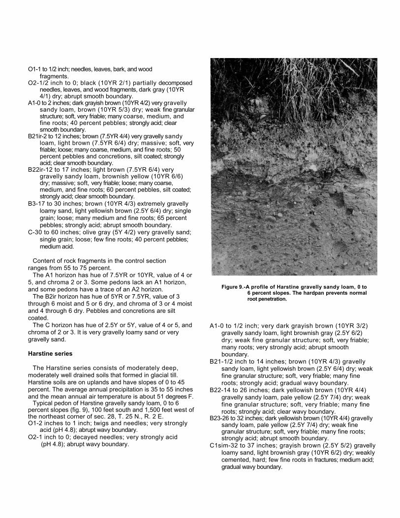
O1-1 to 1/2 inch; needles, leaves, bark, and woodfragments.
O2-1/2 inch to 0; black (10YR 2/1) partially decomposedneedles, leaves, and wood fragments, dark gray (10YR4/1) dry; abrupt smooth boundary.
A1-0 to 2 inches; dark grayish brown (10YR 4/2) very gravellysandy loam, brown (10YR 5/3) dry; weak fine granularstructure; soft, very friable; many coarse, medium, andfine roots; 40 percent pebbles; strongly acid; clearsmooth boundary.
B21ir-2 to 12 inches; brown (7.5YR 4/4) very gravelly sandyloam, light brown (7.5YR 6/4) dry; massive; soft, veryfriable; loose; many coarse, medium, and fine roots; 50percent pebbles and concretions, silt coated; stronglyacid; clear smooth boundary.
B22ir-12 to 17 inches; light brown (7.5YR 6/4) verygravelly sandy loam, brownish yellow (10YR 6/6)dry; massive; soft, very friable; loose; many coarse,medium, and fine roots; 60 percent pebbles, silt coated;strongly acid; clear smooth boundary.
B3-17 to 30 inches; brown (10YR 4/3) extremely gravellyloamy sand, light yellowish brown (2.5Y 6/4) dry; singlegrain; loose; many medium and fine roots; 65 percentpebbles; strongly acid; abrupt smooth boundary.
C-30 to 60 inches; olive gray (5Y 4/2) very gravelly sand;single grain; loose; few fine roots; 40 percent pebbles;medium acid.
Content of rock fragments in the control sectionranges from 55 to 75 percent.
The A1 horizon has hue of 7.5YR or 10YR, value of 4 or5, and chroma 2 or 3. Some pedons lack an A1 horizon,and some pedons have a trace of an A2 horizon.
The B2ir horizon has hue of 5YR or 7.5YR, value of 3through 6 moist and 5 or 6 dry, and chroma of 3 or 4 moistand 4 through 6 dry. Pebbles and concretions are siltcoated.
The C horizon has hue of 2.5Y or 5Y, value of 4 or 5, andchroma of 2 or 3. It is very gravelly loamy sand or verygravelly sand.
Harstine series
The Harstine series consists of moderately deep,moderately well drained soils that formed in glacial till.Harstine soils are on uplands and have slopes of 0 to 45percent. The average annual precipitation is 35 to 55 inchesand the mean annual air temperature is about 51 degrees F.
Typical pedon of Harstine gravelly sandy loam, 0 to 6percent slopes (fig. 9), 100 feet south and 1,500 feet west ofthe northeast corner of sec. 28, T. 25 N., R. 2 E.O1-2 inches to 1 inch; twigs and needles; very strongly
acid (pH 4.8); abrupt wavy boundary.O2-1 inch to 0; decayed needles; very strongly acid
(pH 4.8); abrupt wavy boundary.
Figure 9.-A profile of Harstine gravelly sandy loam, 0 to6 percent slopes. The hardpan prevents normalroot penetration.
A1-0 to 1/2 inch; very dark grayish brown (10YR 3/2)gravelly sandy loam, light brownish gray (2.5Y 6/2)dry; weak fine granular structure; soft, very friable;many roots; very strongly acid; abrupt smoothboundary.
B21-1/2 inch to 14 inches; brown (10YR 4/3) gravellysandy loam, light yellowish brown (2.5Y 6/4) dry; weakfine granular structure; soft, very friable; many fineroots; strongly acid; gradual wavy boundary.
B22-14 to 26 inches; dark yellowish brown (10YR 4/4)gravelly sandy loam, pale yellow (2.5Y 7/4) dry; weakfine granular structure; soft, very friable; many fineroots; strongly acid; clear wavy boundary.
B23-26 to 32 inches; dark yellowish brown (10YR 4/4) gravellysandy loam, pale yellow (2.5Y 7/4) dry; weak finegranular structure; soft, very friable; many fine roots;strongly acid; abrupt smooth boundary.
C1sim-32 to 37 inches; grayish brown (2.5Y 5/2) gravellyloamy sand, light brownish gray (10YR 6/2) dry; weaklycemented, hard; few fine roots in fractures; medium acid;gradual wavy boundary.

C2-37 inches; compact, weakly cemented glacial till,many feet thick.
Depth to the cemented Csim horizon is 25 to 40 inches.Content of rock fragments ranges from 15 to 35 percent.Some pedons have a trace of an A2 horizon and faintmottles in the lower part of the B2 horizon.
The B horizon has hue of 10YR or 7.5YR, value of 3 or4 moist and 5 through 7 dry, and chroma of 3 or 4 moistor dry.
The Csim horizon has hue of 10YR or 2.5Y, value of 4through 6, and chroma of 2 through 4. In some pedons theCsim horizon has mottles along fractures.
Indianola ser ies
The Indianola series consists of deep, somewhatexcessively drained soils that formed in sandy glacialoutwash. Indianola soils are on eskers and kames on broaduplands and have slopes of 0 to 70 percent. The averageannual precipitation is 30 to 55 inches and the meanannual air temperature is about 50 degrees F.
Typical pedon of Indianola loamy sand, 0 to 6 percentslopes, 900 feet north and 600 feet west of the southeastcorner of sec. 36, T. 24 N., R. 1 E.
O1-1/2 inch to 0; undecomposed needles, twigs,leaves, and bark; medium acid.
B21ir-0 to 7 inches; dark brown (7.5YR 3/4) loamy sand,brownish yellow (10YR 6/6) dry; weak fine subangularblocky structure; soft, very friable; many fine roots; mediumacid; clear smooth boundary.
B22ir-7 to 18 inches; dark yellowish brown (10YR 4/4)loamy sand, light yellowish brown (2.5Y 6/4) dry; weakfine subangular blocky structure; soft, very friable; manyfine roots; medium acid; clear smooth boundary.
B3-18 to 29 inches; dark yellowish brown (10YR 4/4)loamy sand, pale yellow (2.5Y 7/4) dry; single grain;loose; many fine roots; medium acid; clear smoothboundary.
C1-29 to 57 inches; olive brown (2.5Y 4/4) sand, paleyellow (5Y 8.4) dry; single grain; loose; many fineroots; medium acid; gradual smooth boundary.
C2-57 to 72 inches; dark grayish brown (2.5Y 4/2)sand, pale yellow (2.5Y 7/4) dry; single grain; loose;few fine roots; medium acid.
The content of rock fragments is less than 15 percent.Some pedons have a thin, dark A1 horizon.
The Bir horizon has hue of 10YR or 7.5YR, value of 3 or 4moist, and chroma of 3 or 4. It is loamy sand or sand.
The C horizon has hue of 2.5Y or 5 Y, value of 4through 6, and chroma of 2 through 4. It is loamy finesand or sand.
Kapow sin ser iesThe Kapowsin series consists of moderately deep,
moderately well drained soils that formed in glacial till(fig. 10). Kapowsin soils are on broad uplands and
Figure 10.-A profile of Kapowsin gravelly loam, 6 to 15percent slopes.

terraces and have slopes of 0 to 15 percent. The averageannual precipitation is 30 to 45 inches and the mean annualair temperature is about 50 degrees F.
Typical pedon of Kapowsin gravelly loam, 0 to 6 percentslopes, 2,100 feet east and 1,300 feet south of thenorthwest corner of sec. 12. T. 25 N., R. 1 E.
A1-0 to 5 inches; dark brown (7.5YR 3/2) gravelly loam,dark grayish brown (10YR 4/2) dry; weak fine granularstructure; loose, friable, nonsticky and nonplastic; manyfine roots; many hard, dark brown concretions, 2 to 5millimeters; 10 percent gravel, few cobbles; medium acid;abrupt smooth boundary.
B2cn-5 to 19 inches; brown (7.5YR 4/4) gravelly loam,pale brown (10YR 6/3) dry; weak fine subangular blockystructure; soft, friable, nonsticky and slightly plastic;common fine roots; many hard, dark brown concretions,2 to 5 millimeters; medium acid; gradual smoothboundary.
B3-19 to 23 inches; dark yellowish brown (10YR 4/4)gravelly loam, pale yellow (2.5Y 7/4) dry; weak finesubangular blocky structure; soft, friable, nonstickyand slightly plastic; common fine roots; medium acid;abrupt smooth boundary.
Csim-23 to 60 inches; olive brown (2.5Y 4/4, rubbed)gravelly loam, white (5Y 8/1) dry; common mediumdistinct strong brown (7.5YR 5/8) mottles; weaklycemented; hard, very firm; breaks into medium, roughplates; slightly acid.
A few stones and cobbles occur throughout the soil.Depth to the Csim horizon ranges from 20 to 32 inches.
The A horizon has hue of 7.5YR or 10YR, value of 3 or4, and chroma of 2 or 3. Some pedons lack an A horizon.
The B horizon has hue of 7.5YR or 10YR, value of 3through 5 moist and 5 through 7 dry, and chroma of 3 or 4moist or dry. Some pedons have mottles in the lower part ofthe B horizon. The B horizon is gravelly loam or gravellysandy loam.
Kapowsin VariantThe Kapowsin Variant consists of moderately deep,
moderately well drained soils that formed in thin lacustrinesediment over glacial till. Kapowsin Variant soils are onlow terraces and have slopes of 0 to 5 percent. Theaverage annual precipitation is 40 to 50 inches and themean annual air temperature is about 51 degrees F.
Typical pedon of Kapowsin Variant gravelly clayloam, 0 to 5 percent slopes, 1,200 feet east and 800 feetsouth of the northwest corner of sec. 4, T. 24 N., R. 1 E.O1-1 to 1/2 inch; twigs and needles; abrupt smooth
boundary.O2-1/2 inch to 0; decayed needles, leaves, and wood
fragments; abrupt smooth boundary.
A1-0 to 7 inches; dark reddish brown (5YR 3/2) gravellyclay loam, light brownish gray (10YR 6/2) dry; strongfine granular structure; hard, friable, sticky and plastic;many coarse, medium, and fine roots; 15 percent hard,dark brown concretions, 2 to 5 millimeters; mediumacid; abrupt smooth boundary.
B21-7 to 13 inches; brown (10YR 4/3) gravelly silty clayloam, very pale brown (10YR 7/3) dry; moderate finesubangular blocky structure; slightly hard, friable, stickyand plastic; many coarse, medium, and fine roots; 20percent pebbles, many concretions, 2 to 5 millimeters;medium acid; clear smooth boundary.
B22-13 to 20 inches; brown (10YR 5/3) gravelly siltyclay loam, light brownish gray (2.5Y 6/2) dry; commonmedium distinct gray (5Y 6/1) and strong brown(7.5YR 5/6) mottles; moderate medium subangularblocky structure; slightly hard, friable, sticky and plastic;many coarse, medium, and fine roots; 25 percentpebbles; medium acid; abrupt smooth boundary.
C1sim-20 to 24 inches; yellowish brown (10YR 5/4) gravellyloam, light brownish gray (2.5Y 6/2) dry; commonmedium distinct light gray (2.5Y 7/2) and strong brown(7.5YR 5/8) mottles; strong medium platy structure;weakly-silica-cemented; very hard, very firm; few fineroots along fractures; 30 percent pebbles; medium acid.
C2sim-24 to 60 inches; dark grayish brown (2.5Y 4/2)gravelly loam, light gray (2.5Y 7/2) dry; massive;compact and weakly cemented in places.
Depth to the weakly-silica-cemented Csim horizon is 20to 35 inches. The content of rock fragments ranges from10 to 30 percent.
The A1 horizon has hue of 5YR or 10YR, value of 2 or3, and chroma of 2 or 3.
The B horizon has hue of 7.5YR or 10YR, value of 3through 5, and chroma of 2 through 4. It is loam, siltloam, silty clay loam, gravelly silt loam, or gravelly silty clayloam.
The upper part of Csim horizon has hue of 2.5Y, 5Y, or10YR moist and 2.5Y or 5Y dry; value of 5 or 6 moist or dry; andchroma of 3 or 4 moist. It is gravelly loam or gravelly siltloam and is weakly cemented to moderately cemented.
Kilchis seriesThe Kilchis series consists of shallow, well drained soils
that formed in material weathered from basalt. Kilchis soilsare on ridge crests and side slopes and have slopes of 15to 70 percent. The average annual precipitation is 65 to 80inches and the mean annual air temperature is about 47degrees F.
Typical pedon of Kilchis very gravelly sandy loam, 15to 30 percent slopes, 1,900 feet east and 20 feet south ofthe northwest corner of sec. 29, T. 24 N., R. 1 E.
boundary.O2-1/2 inch to 0; decayed needles and plant material;
abrupt wavy boundary.A1-0 to 5 inches; dark reddish brown (5YR 3/2) very
gravelly sandy loam, reddish gray (5YR 5/2) dry; weakfine granular structure; soft, very friable; many fine roots;mixed subangular and angular pebbles with a fewcobbles; very strongly acid; abrupt smooth boundary.
B2-5 to 19 inches; dark reddish brown (5YR 3/3)extremely gravelly loam, reddish brown (5YR 4/3) dry;moderate fine granular structure; soft, very friable;many fine roots; 60 percent mixed subangular andangular pebbles, a few cobbles; very strongly acid; clearwavy boundary.
R-19 inches; fractured basalt.
Depth to bedrock is 16 to 20 inches. Some pedons havea thin A2 horizon. The soils have umbric epipedons 7 to20 inches thick.
The A1 horizon has hue of 5YR or 7.5YR and value of 2or 3 moist and 4 or 5 dry.
The B horizon has hue of 5YR or 7.5YR, value of 2 or 3moist and 4 or 5 dry, and chroma of 3 or 4 moist or dry. It isextremely gravelly silt loam or extremely gravelly loam.
Kitsap ser ies
The Kitsap series consists of deep, moderately welldrained soils that formed in glacial lake sediment. Kitsapsoils are on terraces and have slopes of 0 to 70 percent.The average annual precipitation is 30 to 45 inches andthe mean annual air temperature is about 50 degrees F.
Typical pedon of Kitsap silt loam, 8 to 15 percent slopes,20 feet west and 600 feet south of the northeast corner ofsec. 31, T. 24 N., R 1 E.
A1-0 to 5 inches; very dark grayish brown (10YR 3/2) siltloam, light yellowish brown (10YR 6/4) dry; weak finegranular structure; soft, friable, slightly sticky andslightly plastic; common coarse, medium, and fineroots; 5 percent concretions, 2 to 5 millimeters; mediumacid; abrupt smooth boundary.
B21-5 to 13 inches; dark yellowish brown (10YR 4/4) siltloam, light yellowish brown (2.5Y 6/4) dry; many largefaint olive gray (5Y 5/2) and distinct strong brown(7.5YR 5/8) mottles; moderate medium subangular blockystructure; hard, firm, slightly sticky and slightly plastic; fewcoarse and medium roots; 5 percent concretions, 2 to 5millimeters; medium acid; gradual wavy boundary.
B22-13 to 35 inches; light olive brown (2.5Y 5/4) silty clayloam, pale olive (5Y 6/3) dry; common mediumprominent strong brown (7.5YR 5/8) mottles;moderate medium subangular blocky structure; hard,
firm, sticky and plastic; few fine roots; medium acid;gradual wavy boundary.
C1-35 to 48 inches; olive (5Y 5/3) heavy silt loam, paleyellow (5Y 7/3) dry; common medium distinct pale olive(5Y 6/3) and strong brown (7.5 YR 5/8) mottles; finestratification; soft, friable, slightly sticky and slightlyplastic; medium acid; abrupt smooth boundary.
C2-48 to 56 inches; olive (5Y 5/3) silty clay loam, paleyellow (5Y 7/3) dry; common medium distinct paleolive (5Y 6/3) and strong brown (7.5Y 5/8) mottles;fine stratification; slightly hard, friable, slightly stickyand slightly plastic; medium acid; abrupt smoothboundary.
C3-56 to 63 inches; olive (5Y 5/3) silt, pale yellow (5Y8/3) dry; medium to coarse stratification; soft, friable,nonsticky and nonplastic; medium acid.
The content of rock fragments in the soil averages lessthan 5 percent. Depth to prominent mottles ranges from 13to 24 inches.
The A horizon has value of 2 through 4 moist and 4through 6 dry, and chroma of 2 or 3 moist and 2 to 4 dry.
The upper part of the B horizon has value of 3 or 4moist and 5 or 6 dry and chroma of 3 or 4 moist or dry. Itis silt loam or silty clay loam.
The lower part of the B horizon has hue of 10YR or 2.5Y, valueof 4 through 6 moist and 6 through 8 dry, and chroma of 2through 4 moist or dry. It is silt loam or silty clay loam.
The C horizon has hue of 2.5Y or 5Y, value of 5 or 6,and chroma of 2 through 4. It is silt loam or silty clay loam.Some pedons contain thin to coarse strata of silty clay, silt,or fine sand.
McKenna seriesThe McKenna series consists of moderately deep, poorly
drained soils that formed in glacial till. McKenna soils arein upland and terrace depressions and alongdrainageways and have slopes of 0 to 6 percent. Theaverage annual precipitation is 35 to 50 inches and themean annual air temperature is about 50 degrees F.
Typical pedon of McKenna gravelly loam, 1,900 feet eastand 1,150 feet south of the northwest corner of sec. 1, T.22 N., R. 1 E.
O1-3 to 2 inches; twigs, needles, bark, and woodfragments; abrupt wavy boundary.
O2-2 inches to 0; partially decomposed needles, leaves,and wood fragments; abrupt wavy boundary.
A1-0 to 6 inches; dark reddish brown (5YR 2/2) gravellyloam, dark gray (10YR 4/1) dry; weak fine granularstructure; soft, very friable, nonsticky and nonplastic;many coarse, medium, and fine roots; 20

percent pebbles; strongly acid; abrupt smoothboundary.
B21-6 to 8 inches; dark grayish brown (10YR 4/2) gravellysilt loam, grayish brown (10YR 5/2) dry; weak finesubangular blocky structure; slightly hard, very friable,slightly sticky and slightly plastic; few coarse,medium, and fine roots; 25 percent pebbles; stronglyacid; clear smooth boundary.
B22-8 to 16 inches; grayish brown (10YR 5/2) verygravelly loam, light brownish gray (10YR 6/2) dry;moderate medium subangular blocky structure; slightlyhard, friable, nonsticky and nonplastic; very few fine roots;40 percent pebbles; medium acid; gradual smoothboundary.
B23-16 to 28 inches; dark grayish brown (10YR 4/2) verygravelly loam, light brownish gray (2.5Y 6/2) dry;common medium distinct strong brown (7.5YR 5/8)mottles; moderate medium subangular blocky structure;hard, firm, slightly sticky and slightly plastic; 45 percentpebbles; medium acid; abrupt smooth boundary.
C1g-28 to 37 inches; grayish brown (2.5Y 5/2) very gravellyloam, light gray (5Y 7/1) dry; common medium distinctdark olive gray (5Y 3/2) and yellowish brown (10YR 5/4)mottles; compact glacial till; hard, firm, nonsticky andnonplastic; 45 percent pebbles; medium acid; abrupt smoothboundary.
C2-37 to 60 inches; dark greenish gray (5BG 4/1) gravellysilty clay, gray (N 6/0) dry; massive; compact glacialtill; extremely hard, firm, very sticky and very plastic;medium acid.
Depth to the compact glacial till is 30 to 40 inches.Content of rock fragments in the control sectionaverages 35 to 50 percent.
The A1 horizon has hue of 5YR through 10YR, valueof 2 or 3 moist and 2 through 4 dry, and chroma of 1 or 2moist or dry.
The B2 horizon has hue of 10YR or 2.5Y, value of 3through 5 moist and 5 through 7 dry, and chroma of 2through 4 moist or dry. It has fine faint to coarse prominentmottles. The B2 horizon is very gravelly loam, gravellysilt loam, or gravelly clay loam.
The C horizon is compact glacial till. In the lower part, it isgravelly loam, gravelly silty clay, or very gravelly sandyloam.
Mukilteo seriesThe Mukilteo series consists of deep, very poorly drained
soils that formed in organic material. Mukilteo soils are indepressions on upland terraces and along river valleysand have slopes of 0 to 1 percent. The average annualprecipitation is 40 to 70 inches and the mean annual airtemperature is about 50 degrees F.
Typical pedon of Mukilteo peat, 1,800 feet east and 2,100feet south of the northwest corner of sec. 8, T. 23 N., R. 2E.
Oe1-0 to 4 inches; dark reddish brown (5YR 2/2) hemicmaterial, dark grayish brown (10YR 4/2) dry; about 50percent fibers, about 6 percent rubbed; massive;slightly hard, very friable, slightly sticky and slightlyplastic; many fine roots; very strongly acid; abruptsmooth boundary.
Oe2-4 to 44 inches; dark reddish brown (5YR 3/2) hemicmaterial, dark grayish brown (10YR 4/2) dry; about 65percent fibers, about 20 percent rubbed; hard, veryfriable, nonsticky and slightly plastic; few fine roots;very strongly acid; clear smooth boundary.
Oe3-44 to 72 inches; dark reddish brown (5YR 3/2)hemic material, dark grayish brown (10YR 4/2) dry;about 60 percent fibers, about 25 percent rubbed; hard,friable, nonsticky and slightly plastic; very strongly acid.
Some pedons have a thin layer of sapric material at thesurface. Hue is 5YR or 7.5YR and value and chroma rangefrom 2 through 4.
Neilton seriesThe Neilton series consists of deep, excessively drained
soils that formed in gravelly and sandy glacial outwash.Neilton soils are on terraces, beaches, and uplands andhave slopes of 0 to 30 percent. The average annualprecipitation is 30 to 55 inches and the mean annual airtemperature is about 50 degrees F.
Typical pedon of Neilton gravelly loamy sand, 15 to 30percent slopes, 2,100 feet west and 600 feet south of thenortheast corner of sec. 9, T. 22 N., R. 1 E.
O1-1/2 inch to 0; undecomposed needles, twigs, and moss.A1-0 to 4 inches; dark brown (10YR 3/3) gravelly loamy
sand, brown (10YR 5/3) dry; single grain; loose; manycoarse, medium, and fine roots; about 30 percentpebbles; strongly acid; clear smooth boundary.
B2ir-4 to 19 inches; dark brown (7.5YR 3/4) very gravellyloamy sand, light yellowish brown (10YR 6/4) dry; singlegrain; loose; many coarse, medium, and fine roots; 35percent pebbles; strongly acid; clear wavy boundary.
C-19 to 60 inches; multicolored, very gravelly sand;single grain; loose; few fine roots to a depth of 36inches; 60 percent pebbles; medium acid.
Content of rock fragments in the control sectionaverages 35 to 70 percent.
The A1 horizon has hue of 7.5YR or 10YR, value of 3 or4 moist and 4 or 5 dry, and chroma of 2 or 3 moist or dry.
The B2ir horizon has hue of 7.5YR or 10YR, value of 3 or 4moist and 5 or 6 dry, and chroma of 3 or 4 moist or dry.
In some pedons the C horizon has lenses of sand and gravellysand.
Norma seriesThe Norma series consists of deep, poorly drained soils
that formed in mixed glacial alluvium. Norma soils are on tillplain depressions and along drainageways in the uplandsand have slopes of 0 to 3 percent. The average annualprecipitation is 35 to 60 inches and the mean annual airtemperature is about 50 degrees F.
Typical pedon of Norma fine sandy loam, 1,900 feet eastand 400 feet north of the southwest corner of sec. 9, T. 25N., R. 1 E.
Ap-0 to 8 inches; very dark grayish brown (10YR 3/2)fine sandy loam, grayish brown (2.5Y 5/2) dry;moderate fine granular structure; soft, friable, nonstickyand nonplastic; many fine roots; medium acid; abruptsmooth boundary.
B21g-8 to 13 inches; light olive brown (2.5Y 5/4) fine sandyloam, pale yellow (5Y 7/3) dry; common medium distinctstrong brown (7.5YR 5/8) and light olive brown (2/5Y 5/4)mottles; weak fine subangular blocky structure; soft,friable, nonsticky and nonplastic; common fine roots;medium acid; clear smooth boundary.
B22g-13 to 22 inches; light olive brown (2/5Y 5/4) fine sandyloam, pale yellow (5Y 8/3) dry; common medium distinctstrong brown (7.5YR 5/8) and grayish brown (2/5Y 5/2)mottles; weak fine subangular blocky structure; soft,friable, nonsticky and nonplastic; common fine roots;medium acid; abrupt smooth boundary.
C1g-22 to 32 inches; olive gray (5Y 5/2) sandy loam, paleyellow (5Y 8/3) dry; many large distinct strong brown(7.5YR 5/8) mottles; massive; soft, very friable, nonstickyand nonplastic; few fine roots; medium acid; abruptsmooth boundary.
C2g-32 to 36 inches; olive gray (5Y 5/2) clay loam, pale yellow(5Y 8/3) dry; many large distinct strong brown (7.5YR5/8) mottles; massive; slightly hard, friable, slightlysticky and slightly plastic; medium acid; abrupt smoothboundary.
C3-36 to 43 inches; dark yellowish brown (10YR 4/4)loamy sand, light yellowish brown (2.5Y 6/4) dry;massive; loose; medium acid; abrupt smoothboundary.
C4-43 to 60 inches; dark yellowish brown (10YR 4/4)loamy sand, pale yellow (5Y 8/3) dry; massive, slightlycompact; hard, firm, nonsticky and nonplastic; neutral.
Gravel content in the control section ranges from 0 to 15percent.
The A horizon has value of 2 or 3 moist and chroma of1 or 2 moist or dry.
The B horizon has hue of 2.5Y or 5Y and has commonto many distinct and prominent mottles. It is fine sandy loamor sandy loam.
The C horizon is fine sandy loam, sandy loam, or loamysand. Some pedons contain strata of silt, silt loam, clayloam, or gravelly sand in the lower part of the C horizon.
Poulsbo seriesThe Poulsbo series consists of moderately deep,
moderately well drained soils that formed in glacial till.Poulsbo soils are on broad uplands and have slopes of 0to 30 percent. The average annual precipitation is 30 to 40 inchesand the mean annual air temperature is about 51 degrees F.
Typical pedon of Poulsbo gravelly sandy loam, 0 to 6percent slopes, 750 feet east and 750 feet north of thesouthwest corner of sec. 20, T. 26 N., R. 2 E.
O1-2 inches to 1 inch; twigs, needles, bark, and woodfragments; abrupt wavy boundary.
O2-1 inch to 0; decomposed needles, leaves, bark, andwood fragments; abrupt wavy boundary.
A2-0 to 2 inches; dark grayish brown (2.5Y 4/2) gravellysandy loam, light brownish gray (2.5Y 6/2) dry; singlegrain; loose; many fine, medium, and coarse roots; 35percent gravel and fine concretions; strongly acid;abrupt wavy boundary.
B21ir-2 to 9 inches; dark brown (10YR 3/3) gravelly sandyloam, pale brown (10YR 6/3) dry; weak fine granularstructure; soft, very friable; many fine, medium, andcoarse roots; 30 percent gravel; very strongly acid; clearwavy boundary.
B22ir-9 to 24 inches; dark yellowish brown (10YR 4/4)gravelly sandy loam, light yellowish brown (2.5Y 6/4) dry;weak fine granular structure; soft, friable; common fine,medium, and coarse roots; 30 percent gravel; verystrongly acid; clear wavy boundary.
C1sim-24 to 28 inches; light olive brown (2.5Y 5/4) gravellyweakly-silica-cemented sandy loam, light brownish gray(2.5Y 6/2) dry; strong thin platy structure; very hard, veryfirm; weakly cemented; few fine roots; 20 percent gravel;very strongly acid; clear wavy boundary.
C2-28 to 60 inches; olive (5Y 5/3) gravelly sandy loam, light gray(5Y 7/2) dry; massive; weakly cemented in the upper partand very compact; 15 percent gravel; very strongly acid.
Depth to the very compact, weakly-silica-cementedlayer is 20 to 40 inches. The mean annual soiltemperature ranges from 49 degrees to 52 degrees F.The control section has 50 to 75 percent content of sandand 10 to 35 percent content of rock fragments.
The A2 horizon has hue of 10YR or 2.5Y and value of 4 or5 moist and 6 or 7 dry. It is 1 to 4 inches thick and isgravelly sandy loam or gravelly loam.

The B2ir horizon has hue of 10YR or 7.5YR in the upper part and10YR or 2.5Y in the lower part. It has value of 3 or 4 moist andchroma of 3 or 4 moist or dry. The B2ir horizon is gravellysandy loam or gravelly loam. Some pedons have commonfine faint and distinct mottles.
The C horizon has hue of 2.5Y or 5Y. In some pedons,there are common medium distinct mottles along fractureplanes.
Ragnar seriesThe Ragnar series consists of deep, well drained soils
that formed in sandy glacial outwash. Ragnar soils areon terraces and rolling uplands and have slopes of 0 to 30percent. The average annual precipitation ranges from 35 to65 inches and the mean annual temperature is about 50degrees F.
Typical pedon of Ragnar fine sandy loam, 6 to 15percent slopes, 2,000 feet west and 2,500 feet north of thesoutheast corner of sec. 31, T. 24 N., R. 1 E.
O1-3 to 1-1/2 inches; twigs, needles, bark, and woodfragments; abrupt wavy boundary.
O2-1-1/2 inches to 0; decomposed needles, leaves,bark, and wood fragments; abrupt wavy boundary.
A1-0 to 4 inches; dark brown (7.5YR 3/2) fine sandy loam,dark brown (10YR 3/3) dry; weak fine granular structure;soft, friable, nonsticky and nonplastic; common mediumand fine roots; medium acid; abrupt smooth boundary.
B2-4 to 23 inches; dark yellowish brown (10YR 4/4) fine sandyloam, yellow (2.5Y 7/6) dry; few fine faint strong brownmottles; weak medium subangular blocky structure; soft,friable; common medium and fine roots; medium acid; gradualwavy boundary.
C1-23 to 44 inches; grayish brown (2.5Y 5/2) loamy sand,pale yellow (5Y 7/3) dry; few strong brown mottles;massive; soft, friable; few medium and fine roots;medium acid; gradual wavy boundary.
C2-44 to 52 inches; light brownish gray (2.5Y 6/2) loamysand, pale yellow (5Y 7/3) dry; few fine yellowish redmottles; massive; soft, friable; very few fine roots;medium acid; gradual wavy boundary.
C3-52 to 66 inches; light brownish gray (2.5Y 6/2) loamysand, light gray (5Y 7/2) dry; massive; soft, friable;medium acid.
The A horizon has hue of 7.5YR or 10YR and chroma of 2 or 3.The B horizon has hue of 7.5YR, 10YR, or 2.5Y; value of 3
or 4 moist and 4 through 7 dry; and chroma of 4 through 6moist or dry.
The C horizon has hue of 5Y through 10YR, value of 5through 7, and chroma of 2 or 3. It is loamy sand or finesand.
Schneider seriesThe Schneider series consists of deep, well drained soils
that formed in colluvium from basalt. Schneider soils are onuplands and have slopes of 45 to 70 percent. The averageannual precipitation is 60 to 75 inches and the mean annualair temperature is about 49 degrees F.
Typical pedon of Schneider very gravelly loam, 45 to 70percent slopes, 600 feet east and 1,900 feet south of thenorthwest corner of sec. 26, T. 24 N., R. 1 W.
O1-1 to 1/2 inch; needles, leaves, and twigs; scattered angulargravel and cobbles on surface.
O2-1/2 inch to 0; decomposed needles, leaves, andsome ash.
A1-0 to 6 inches; dark reddish brown (5YR 3/3) verygravelly loam, brown (T.5YR 4/4) dry; moderate finegranular structure; soft, friable, nonsticky andnonplastic; many fine roots; 50 percent angular basaltfragments and 10 percent angular cobbles; mediumacid; abrupt smooth boundary.
A3-6 to 23 inches; dark reddish brown (5YR 3/3)extremely gravelly loam, brown (7.5YR 5/4) dry;moderate fine granular structure; soft, friable, nonstickyand nonplastic; many coarse, medium, and fine roots; 50percent angular gravel and 15 percent angular cobbles;medium acid; clear smooth boundary.
B2-23 to 48 inches; dark brown (7.5YR 4/4) extremelygravelly silt loam, very pale brown (10YR 7/4) dry;moderate fine granular structure; soft, friable, slightlysticky and slightly plastic; common coarse, medium,and fine roots; 55 percent angular gravel and 15percent angular cobbles; medium acid; abrupt wavyboundary.
R-48 inches; fractured basalt.
Depth to basalt ranges from 40 to 70 inches. Content ofrock fragments in the control section ranges from 50 to 80percent.
The A1 horizon has hue of 5YR or 7.5YR, value of 2 or3 moist and 4 or 5 dry, and chroma of 2 or 3 moist and 2through 4 dry. It is very gravelly loam or very gravelly siltloam. The A3 horizon has hue of 5YR or 7.5YR, value of 2or 3 moist and 3 through 5 dry, and chroma of 3 or 4 dry. Itis very gravelly loam, very gravelly silt loam, or extremelygravelly loam.
The B2 horizon has hue of 5YR, 7.5YR, or 10YR. It isextremely gravelly silt loam or very gravelly silt loam.
Semiahmoo seriesThe Semiahmoo series consists of deep, very poorly
drained soils that formed in organic material. Semiahmoosoils are in depressional backwater areas of flood plains andhave slopes of 0 to 1 percent. The average annualprecipitation is 35 to 50 inches and the mean annual airtemperature is about 49 degrees F.

Typical pedon of Semiahmoo muck, 900 feet west and1,200 feet south of the northeast corner of sec. 6 T. 23 N.,R. 2 E.
Oap-0 to 8 inches; black (5YR 2/1) sapric material, darkgray (10YR 4/1) dry; about 15 percent fibers, less than5 percent rubbed; moderate fine granular structure; slightlyhard, very friable, slightly sticky . and slightly plastic;many fine roots; strongly acid; clear smoothboundary.
Oa1-8 to 20 inches; black (5YR 2/1) sapric material,dark gray (10YR 4/1) dry; about 15 percent fibers,less than 5 percent rubbed; moderate mediumsubangular blocky structure; slightly hard, very friable,slightly sticky and slightly plastic; many fine roots;strongly acid; abrupt smooth boundary.
Oa2-20 to 66 inches; black (5YR 2/1) sapric material,dark gray (10YR 4/1) dry; 50 percent fibers, less than15 percent rubbed; massive; hard, very friable, nonstickyand slightly plastic; few fine roots; very strongly acid;abrupt smooth boundary.
The organic layers below the Oap horizon have hue of5YR through 10YR. Chroma is 1 or 2.
The organic layer ranges from 55 inches to more than 120inches in thickness.
Shalcar seriesThe Shalcar series consists of deep, very poorly
drained soils that formed in organic material overalluvium. Shalcar soils are in valleys and upland depressionsand have slopes of 0 to 1 percent. The average annualprecipitation is 35 to 60 inches and the mean annual airtemperature is about 49 degrees F.
Typical pedon of Shalcar muck, 1,800 feet east and 1,750feet south of the northwest corner of sec. 8, T. 23 N., R. 2E.
Oap-0 to 8 inches; very dark brown (10YR 2/2) sapricmaterial, gray (2.5Y 5/1) dry; many large prominentstrong brown (7.5YR 5/6) mottles; about 15 percentfibers, less than 5 percent rubbed; moderate mediumgranular structure; slightly hard, very friable, slightly stickyand slightly plastic; many fine roots; strongly acid; abruptsmooth boundary.
Oa1-8 to 32 inches; very dark brown (10YR 2/2) sapricmaterial, brown (10YR 4/3) dry; dark gray (5Y 4/1)pockets of fine sand; about 10 percent fibers, less than5 percent rubbed; moderate thin platy structure; slightlyhard, very friable, slightly sticky and slightly plastic;common fine roots; very strongly acid; clear wavyboundary.
C-32 to 60 inches; very dark gray (2.5YR 3/1) stratifiedloamy sand with lenses of finer material, gray (5Y 5/1)dry; common medium prominent dark yellowish
brown (10YR 4/4)-mottles; massive; loose; few fineroots; very strongly acid.
The organic horizons have 10 to 25 percent fibersunrubbed and less than 10 percent rubbed.
Depth to the mineral horizon ranges from 20 to 40 inches.The mineral horizons are stratified silty clay loam, silt loam,fine sandy loam, sandy loam, loamy sand, and sand.
Shelton seriesThe Shelton series consists of moderately deep,
moderately well drained soils that formed in glacial till andhas some basalt fragments. Shelton soils are on morainesand till plains and have slopes of 0 to 45 percent. Theaverage annual precipitation is 50 to 70 inches and themean annual air temperature is about 49 degrees F.
Typical pedon of Shelton very gravelly sandy loam, 15 to30 percent slopes, 2,500 feet west and 1,200 feet south ofthe northeast corner of sec. 23, T. 24 N., R. 1 W.
O1-2 inches to 1 inch; needles, leaves, and twigs.O2-1 inch to 0; decomposed leaves, needles, and
wood fragments; burned residue; abrupt smoothboundary.
B21cn-0 to 3 inches; dark reddish brown (5YR 3/3) very gravellysandy loam, brown (7.5YR 5/4) dry; moderate finegranular structure; soft, friable; many coarse, medium,and fine roots; 30 percent pebbles and 20 percent darkbrown (7.5YR 4/4) concretions, 2 to 5 millimeters;strongly acid; clear smooth boundary.
B22cn-3 to 18 inches; dark reddish brown (5YR 3/4) verygravelly sandy loam, brown (7.5YR 5/4) dry; moderatefine granular structure; soft, friable; many coarse,medium, and fine roots; 15 percent pebbles; 20 percentdark brown (7.5YR 4/4) concretions, 2 to 5 millimeters;20 percent angular basalt cobbles; strongly acid; gradualwavy boundary.
B3cn-18 to 25 inches; dark brown (7.5YR 3/4) verygravelly sandy loam, yellowish brown (10YR 5/4) dry;moderate fine granular structure; soft, friable;many coarse, medium, and fine roots; dense rootmat in lower horizon; 55 percent pebbles andcobbles; strongly acid; abrupt smooth boundary.
Csim-25 to 60 inches; grayish brown (2.5Y 5/2) verygravelly sandy loam, light olive gray (5Y 6/2) dry;massive; extremely hard, weakly-silica-cemented,very compact glacial till; 65 percent pebbles; stronglyacid.
Depth to the Csim horizon ranges from 20 to 35 inches.Content of rock fragments in the soil ranges from
40 to 75 percent. Some pedons contain a few angular basalticfragments. Some pedons have a thin Al horizon.
The Bcn horizon has hue of 5YR or 7.5YR, value of 3 or4 moist, and chroma of 3 or 4 moist or dry. Some pedonshave pockets of glacial flour deposited in the lower part ofthe B horizon. The Bcn horizon is very gravelly sandy loam orextremely gravelly sandy loam.
The Csim horizon has hue of 2.5Y or 5Y and value of 5 or6 moist or dry.
Sinclair series
The Sinclair series consists of moderately deep,moderately well drained soils that formed in glacial till. Sinclairsoils are on till plains and have slopes of 2 to 30 percent. Theaverage annual precipitation is 30 to 40 inches and themean annual air temperature is about 51 degrees F.
Typical pedon of Sinclair very gravelly sandy loam, 2 to 8percent slopes, 1,900 feet west and 2,500 feet south of thenortheast corner of sec. 2, T. 26 N., R. 2 E.
O1-2 to 1-1/2 inches; needles, leaves, and twigs.O2-1-1/2 inch to 0; black (5YR 2/1) partially decayed
needles, leaves, bark, and wood fragments; verystrongly acid; abrupt wavy boundary.
A2-0 to 2 inches; grayish brown (10YR 5/2) sandy loam,light brownish gray (2.5Y 6/2) dry; weak fine granularstructure; soft, very friable; common fine roots; 10 percentgravel and fine gravel-size concretions; very strongly acid;clear wavy boundary.
B21ir-2 to 8 inches; yellowish brown (10YR 5/4) very gravellysandy loam, pale brown (10YR 6/3) dry; weak finegranular structure; soft, very friable; many coarse,medium, and fine roots; 30 percent gravel and 10percent fine gravel-size concretions; very strongly acid;clear smooth boundary.
B22ir-8-to 15 inches; yellowish brown (10YR 5/4) verygravelly sandy loam, pale brown (10YR 6/3) dry; manyfine faint light gray (10YR 7/2) mottles; weak mediumgranular structure; soft, very friable; many coarsemedium and fine roots; 40 percent gravel; very stronglyacid; clear smooth boundary.
B23-15 to 25 inches; yellowish brown (10YR 5/4) verygravelly sandy loam, light yellowish brown (10YR 6/4)dry; weak fine granular structure; soft, very friable; manycoarse and medium roots; 40 percent gravel; stronglyacid; abrupt smooth boundary.
Csim-25 to 60 inches; light olive brown (2.5Y 5/4)gravelly loamy sand, light brownish gray (2.5Y 6/2) dry;massive; hard; weakly-silica-cemented, very compact;medium acid.
Depth to the Csim horizon ranges from 20 to 30 inches.Content of rock fragments ranges from 35 to 50 percent inthe control section.
The A2 horizon has hue of 10YR or 2.5Y, value of 4 or 5moist, and chroma of 1 or 2 moist or dry.
The B2ir horizon has hue of 7.5YR or 10YR, value of 4 or5 moist, and chroma of 3 or 4 moist or dry. It has weakgranular or subangular blocky structure.
The Csim horizon has hue of 2.5Y or 10YR. It is gravellysandy loam or gravelly loamy sand. It is weakly- tomoderately-silica-cemented and very compact.
Tacoma series
The Tacoma series consists of deep, very poorly drainedsoils that formed in alluvial deposits and organic material.Tacoma soils are on deltas and have slopes of 0 to 3 percent. Theaverage annual precipitation is 35 to 60 inches and the meanannual air temperature is about 50 degrees F.
Typical pedon of Tacoma silt loam, 1,050 feet east and 600feet north of the southwest corner of sec. 17, T. 24 N., R. 2W.
A1-0 to 6 inches; very dark grayish brown (10YR 3/2) siltloam, grayish brown (10YR 5/2) dry; moderate finegranular structure; soft, very friable, nonsticky and slightlyplastic; many fine roots; very strongly acid; clearsmooth boundary.
C1-6 to 10 inches; dark grayish brown (2.5Y 4/2) very gravellyloamy sand, grayish brown (2.5Y 5/2) dry; weak finegranular structure; loose; common fine roots; 40 percentpebbles; very strongly acid; abrupt smooth boundary.
C2g-10 to 17 inches; dark grayish brown (2.5Y 4/2) loam, lightolive gray (5Y 6/2) dry; common medium distinct strongbrown (7.5YR 5/8) mottles; massive; soft, very friable,nonsticky and slightly plastic; weakly smeary; few fineroots; very strongly acid; clear smooth boundary.
C3g-17 to 21 inches; very dark grayish brown (10YR 3/2) siltyclay loam, light olive gray (5Y 6/2) dry; common mediumdistinct strong brown (7.5YR 5/8) mottles; massive; soft,very friable, slightly sticky and plastic; weakly smeary;very strongly acid; clear smooth boundary.
C4-21 to 24 inches; dark brown (10YR 3/3) loam, light olive gray(5Y 6/2) dry; massive; soft, very friable, nonsticky andslightly plastic; weakly smeary; very strongly acid; abruptsmooth boundary.
C5-24 to 36 inches; very dark grayish brown (2.5Y 3/2) very finesandy loam, light brownish gray (2.5Y 6/2) dry; commonfine distinct strong brown (7.5YR 5/8) mottles; massive;soft, very friable, nonsticky and nonplastic; weaklysmeary; very strongly acid; abrupt smooth boundary.

C6-36 to 60 inches; olive gray (5Y 4/2) very gravellycoarse sand, gray (5Y 6/1) dry; common medium faintyellowish red (5YR 5/8) mottles; single grain; loose;very strongly acid.
Some pedons have layers of muck, each 1 to 4 inchesthick, with a cumulative total of less than 16 inches.
The A1 horizon has hue of 10YR or 5Y, value of 3 or 4,and chroma of 1 or 2.
The C horizon has hue of 10YR through 5Y, value of 3 through 5moist, and chroma of 2 or 3 moist or dry. Mottles rangefrom faint to prominent. The lower part of the C horizonranges from clay to very gravelly coarse sand andchanges within short distances.

references
(1)American Association of State Highway [and Transportation] Officials. 1970. Standard specifications for (11)
(2)
highway materials and methods of sampling andtesting. Ed. 10, 2 vol., illus.
American Society for Testing and Materials. 1974. (12)
(3)
Method for classification of soils for engineering purposes. ASTM Stand. D 2487-69. In 1974 AnnualBook of ASTM Standards, Part 19, 464 pp., illus.
Chambers, Charles J., and Franklin M. Wilson. 1972. (13)
(4)
Yield tables for the Douglas-fir zone. State of Washington Dept. Nat. Resources Report 22-R.
Garling, M. E., Dee Molenaar, E. G. Bailey, A. S.Van Denburgh, and G. H. Fiedler. 1965. Water re
(14)
sources and geology of the Kitsap peninsula andcertain adjacent islands. State of Washington Div.Water Resources Water Supply Bull. 18, 309 pp.,illus. (15)
(5)
(6)
King, James E. 1966. Site curves for Douglas-fir inthe Pacific Northwest. Weyerhauser Co. ForestryPaper 8.
(16)
(7)
McArdle, R. E., W. H. Meyer, and D. Bruce. 1961.The yield of Douglas-fir in the Pacific Northwest.U.S. Dep. Agric. Tech. Bull. 201, 74 pp.
(17)
(8)
McCreary, Fred R., and Miles L. Raver. 1975. Soilsurvey of Jefferson County Area, Washington. U. S.Dept. Agric.
(18)
(9)Portland Cement Association. 1973. PCA soil primer.
Puget Sound Council of Governments and KitsapCounty Department of Community Development.1972, updated 1975. Land use survey. (19)
(10)Rigg, George B. 1958. Peat resources of Washing
ton. State of Washington Div. Mines and Geol. Bull.44, 272 pp.
Snyder, Dale E., Philip S. Gale, and Russell F.Pringle. 1973. Soil survey of King County Area,Washington. U. S. Dept. Agric.
United States Department of Agriculture. 1951. Soilsurvey manual. U. S. Dep. Agric. Handb. 18, 503pp., illus. [Supplements replacing pp. 173-188 issuedMay 1962]
United States Department of Agriculture. 1972. Na-tional engineering handbook. Sec. 4, Hydrol., Ch. 7,pp. 7.1 to 7.2.
United States Department of Agriculture. 1961. Landcapability classification. U.S. Dep. Agric. Handb. 210,21 pp.
United States Department of Agriculture. 1975. Soiltaxonomy: A basic system of soil classification formaking and interpreting soil surveys. Soil Conserv.Serv., U.S. Dep. Agric. Handb. 436, 754 pp., illus.
United States Department of Health, Education, andWelfare. 1957. Manual of septic tank practices.Public Health Serv. Pub[. 526, 93 pp., illus.
Wildermuth, Robert, S. O. Perkins, R. E. Pasco, andE. H. Hubbard. 1939. Soil survey of Kitsap County,Washington. U. S. Dept. Agric., 41 pp.
Worthington, N. P., F. A. Johnson, G. R. Staebler,and W. J. Lloyd. 1960. Normal yield tables for redalder. U. S. Dept. Agric. Research Paper 36, ForestService.
Zulauf, Allen S. 1978. Soil survey of Pierce CountyArea, Washington. U. S. Dept. Agric.
glossaryABC soil. A soil having an A, a B, and a C horizon.,Ablation till. Loose, permeable till deposited during the final
downwasting of glacial ice. Lenses of crudely sortedsand and gravel are common.
AC soil. A soil having only an A and a C horizon. Commonlysuch soil formed in recent alluvium or on steep rockyslopes.
Alluvium. Material, such as sand, silt, or clay, depositedon land by streams.
Area reclaim (in tables). An area difficult to reclaim after theremoval of soil for construction and other uses.Revegetation and erosion control are extremely difficult.
Available water capacity (available moisture capacity). Thecapacity of soils to hold water available for use by mostplants. It is commonly defined as the difference betweenthe amount of soil water at field moisture capacity andthe amount at wilting point. It is commonly expressed asinches of water per inch of soil. The capacity, in inches,in a 60-inch profile or to a limiting layer is expressed as
InchesVery low...............................................................0 to 3Low................................................................... 3 to 6Moderate ............................................................6 to 9High .................................................................9 to 12Very high.................................................. More than 12
Basal area. The area, in square feet, of the cross section atbreast height of the trees above a stated size in anacre.
Basal till. Compact glacial till deposited beneath the ice.Base saturation. The degree to which material having
cation exchange properties is saturated withexchangeable bases (sum of Ca, Mg, Na, K), expressed asa percentage of the total cation exchange capacity.
Bedrock. The solid rock that underlies the soil and otherunconsolidated material or that is exposed at thesurface.
Bench terrace. A raised, level or nearly level strip ofearth constructed on or nearly on a contour,supported by a barrier of rocks or similar material,and designed to make the soil suitable for tillage andto prevent accelerated erosion.
Bottom land. The normal flood plain of a stream,subject to flooding.
Boulders. Rock fragments larger than 2 feet (60centimeters) in diameter.
Clay. As a soil separate, the mineral soil particles less than0.002 millimeter in diameter. As a soil textural class,soil material that is 40 percent or more clay, less than45 percent sand, and less than 40 percent silt.
Clay film. A thin coating of oriented clay on the surface of asoil aggregate or lining pores or root channels.Synonyms: clay coating, clay skin.
CMAI. Culmination of the mean annual increment. The ageor rotation at which growing stock of a forestproduces the greatest annual growth (for that timeperiod).
Coarse fragments. If round, mineral or rock particles 2millimeters to 25 centimeters (10 inches) in diameter; ifflat, mineral or rock particles (flagstone) 15.2 to 38.1centimeters (6 to 15 inches) long.
Coarse textured soil. Sand or loamy sand.Cobblestone (or cobble). A rounded or partly rounded
fragment of rock 3 to 10 inches (7.5 to 25 centimeters)in diameter.
Colluvium. Soil material, rock fragments, or both moved bycreep, slide, or local wash and deposited at the base ofsteep slopes.
Complex, soil. A map unit of two or more kinds of soil insuch an intricate pattern or so small in area that it isnot practical to map them separately at the selectedscale of mapping. The pattern and proportion of thesoils are somewhat similar in all areas.
Concretions. Grains, pellets, or nodules of various sizes,shapes, and colors consisting of concentratedcompounds or cemented soil grains. The composition ofmost concretions is unlike that of the surrounding soil.Calcium carbonate and iron oxide are commoncompounds in concretions.
Consistence, soil. The feel of the soil and the ease withwhich a lump can be crushed by the fingers. Termscommonly used to describe consistence areLoose.-Noncoherent when dry or moist; does not holdtogether in a mass.Friable.-When moist, crushes easily under gentlepressure between thumb and forefinger and can bepressed together into a lump.Firm.-When moist, crushes under moderate pressurebetween thumb and forefinger, but resistance is distinctlynoticeable.Plastic.-When wet, readily deformed by moderatepressure but can be pressed into a lump; will form a"wire" when rolled between thumb and forefinger.
Sticky.-When wet, adheres to other material and tendsto stretch somewhat and pull apart rather than to pullfree from other material.Hard.-When dry, moderately resistant to pressure;can be broken with difficulty between thumb andforefinger.Soft.-When dry, breaks into powder or individual grainsunder very slight pressure.Cemented-Hard; little affected by moistening.
Control section. The part of the soil on which classificationis based. The thickness varies among different kinds ofsoil, but for many it is that part of the soil profilebetween depths of 10 inches and 40 or 80 inches.
Corrosive. High risk of corrosion to uncoated steel ordeterioration of concrete.
Cutbanks cave (in tables). The walls of excavationstend to cave in or slough.
Depth to rock (in tables). Bedrock is too near thesurface for the specified use.
Diameter breast-high (DBH). The diameter of a tree 4.5 feetabove average ground level.
Diversion (or diversion terrace). A ridge of earth, generallya terrace, built to protect downslope areas by divertingrunoff from its natural course.
Drainage class (natural). Refers to the frequency andduration of periods of saturation or partial saturationduring soil formation, as opposed to altered drainage,which is commonly the result of artificial drainage orirrigation but may be caused by the suddendeepening of channels or the blocking of drainageoutlets. Seven classes of natural soil drainage arerecognized:Excessively drained-Water is removed from the soilvery rapidly. Excessively drained soils are commonlyvery coarse textured, rocky, or shallow. Some aresteep. All are free of the mottling related to wetness.Somewhat excessively drained-Water is removed from
the soil rapidly. Many somewhat excessively drained soils aresandy and rapidly pervious. Some are shallow. Some areso steep that much of the water they receive is lost asrunoff. All are free of the mottling related to wetness.Well drained.-Water is removed from the soil readily,but not rapidly. It is available to plants throughout mostof the growing season, and wetness does not inhibitgrowth of roots for significant periods during most growingseasons. Well drained soils are commonly medium textured.They are mainly free of mottling.Moderately well drained.-Water is removed from the soil
somewhat slowly during some periods. Moderately welldrained soils are wet for only a short time during thegrowing season, but periodically they are wet longenough that most mesophytic crops are affected.They commonly have a slowly pervious layer within ordirectly below
the solum, or periodically receive high rainfall, orboth.
Somewhat poorly drained-Water is removed slowlyenough that the soil is wet for significant periods duringthe growing season. Wetness markedly restricts thegrowth of mesophytic crops unless artificial drainage isprovided. Somewhat poorly drained soils commonlyhave a slowly pervious layer, a high water table,additional water from seepage, nearly continuousrainfall, or a combination of these.
Poorly drained.-Water is removed so slowly that the soilis saturated periodically during the growing season orremains wet for long periods. Free water is commonlyat or near the surface for long enough during thegrowing season that most mesophytic crops cannot begrown unless the soil is artificially drained. The soil isnot continuously saturated in layers directly below plowdepth. Poor drainage results from a high water table, aslowly pervious layer within the profile, seepage, nearlycontinuous rainfall, or a combination of these.
Very poorly drained-Water is removed from the soil soslowly that free water remains at or on the surfaceduring most of the growing season. Unless the soil isartificially drained, most mesophytic crops cannot begrown. Very poorly drained soils are commonly level ordepressed and are frequently ponded. Yet, whererainfall is high and nearly continuous, they can havemoderate or high slope gradients.
Drainage, surface. Runoff, or surface flow of water,from an area.
Erosion. The wearing away of the land surface by water,wind, ice, or other geologic agents and by suchprocesses as gravitational creep.Erosion (geologic). Erosion caused by geologic processesacting over long geologic periods and resulting in thewearing away of mountains and the building up of suchlandscape features as flood plains and coastal plains.Synonym: natural erosion.Erosion (accelerated). Erosion much more rapid thangeologic erosion, mainly as a result of the activities ofman or other animals or of a catastrophe in nature, forexample, fire, that exposes the surface.
Esker (geology). A narrow, winding ridge of stratifiedgravelly and sandy drift deposited by a streamflowing in a tunnel beneath a glacier.
Excess fines (in tables). Excess silt and clay in the soil. Thesoil does not provide a source of gravel or sand forconstruction purposes.
Fast intake (in tables). The rapid movement of waterinto the soil.
Fertility, soil. The quality that enables a soil to provide plantnutrients, in adequate amounts and in proper balance,for the growth of specified plants when light, moisture,temperature, tilth, and other growth factors arefavorable.

Field moisture capacity. The moisture content of a soil,expressed as a percentage of the ovendry weight,after the gravitational, or free, water has drained away;the field moisture content 2 or 3 days after a soakingrain; also called normal field capacity, normal moisturecapacity, or capillary capacity.
Fine textured soil. Sandy clay, silty clay, and clay.Flood plain. A nearly level alluvial plain that borders a
stream and is subject to flooding unless protectedartificially.
Foot slope. The inclined surface at the base of a hill.Glacial drift (geology). Pulverized and other rock material
transported by glacial ice and then deposited. Alsothe sorted and unsorted material deposited bystreams flowing from glaciers.
Glacial outwash (geology). Gravel, sand, and silt, commonlystratified, deposited by glacial melt water.
Glacial till (geology). Unsorted, nonstratified glacial driftconsisting of clay, silt, sand, and boulderstransported and deposited by glacial ice.
Glaciolacustrine deposits. Material ranging from fine clay tosand derived from glaciers and deposited in glaciallakes mainly by glacial melt water. Many deposits areinterbedded or laminated.
Gravel. Rounded or angular fragments of rock up to 3inches (2 millimeters to 7.5 centimeters) in diameter. Anindividual piece is a pebble.
Gravelly soil material. Material that is 15 to 50 percent, byvolume, rounded or angular rock fragments, notprominently flattened, up to 3 inches (7.5 centimeters) indiameter.
Ground water (geology). Water filling all the unblockedpores of underlying material below the water table.
Hardpan. A hardened or cemented soil horizon, or layer.The soil material is sandy, loamy, or clayey and iscemented by iron oxide, silica, calcium carbonate, orother substance.
Horizon, soil. A layer of soil, approximately parallel to thesurface, having distinct characteristics produced by soil-forming processes. In the identification of soil horizons,an upper case letter represents the major horizons.Numbers or lower case letters that follow representsubdivisions of the major horizons. An explanation ofthe subdivisions is given in the Soil Survey Manual. Themajor horizons of mineral soil are as follows:O horizon.-An organic layer of fresh and decayingplant residue at the surface of a mineral soil.A horizon.-The mineral horizon at or near the surfacein which an accumulation of humified organic matteris mixed with the mineral material. Also, a plowedsurface horizon, most of which was originally part of aB horizon.B horizon.-The mineral horizon below an A horizon.The B horizon is in part a layer of transition from theoverlying A to the underlying C horizon. The B horizonalso has distinctive characteristics such as (1)accumulation of clay, sesquioxides, humus, or a
combination of these; (2) prismatic or blocky structure;(3) redder or browner colors than those in the A horizon;or (4) a combination of these. The combined A and Bhorizons are generally called the solum, or true soil. If asoil does not have a B horizon, the A horizon alone isthe solum.C horizon.-The mineral horizon or layer, excludingindurated bedrock, that is little affected by soil-formingprocesses and does not have the properties typical ofthe A or B horizon. The material of a C horizon may beeither like or unlike that in which the solum formed. Ifthe material is known to differ from that in the solum, theRoman numeral II precedes the letter C.R layer.-Consolidated rock beneath the soil. Therock commonly underlies a C horizon, but can bedirectly below an A or a B horizon.
Hummocky. Refers to a landscape of hillocks, separated bylow sags, having sharply rounded tops and steep sides.Hummocky relief resembles rolling or undulating relief,but the tops of ridges are narrower and the sides areshorter and less even.
Hydrologic soil groups. Refers to soils grouped according totheir runoff-producing characteristics. The chiefconsideration is the inherent capacity of soil bare ofvegetation to permit infiltration. The slope and the kindof plant cover are not considered but are separatefactors in predicting runoff. Soils are assigned to fourgroups. In group A are soils having a high infiltration ratewhen thoroughly wet and having a low runoff potential.They are mainly deep, well drained, and sandy orgravelly. In group D, at the other extreme, are soilshaving a very slow infiltration rate and thus a high runoffpotential. They have a claypan or clay layer at or nearthe surface, have a permanent high water table, or areshallow over nearly impervious bedrock or other material.A soil is assigned to two hydrologic groups if part of theacreage is artificially drained and part is undrained.
Impervious soil. A soil through which water, air, or rootspenetrate slowly or not at all. No soil is absolutelyimpervious to air and water all the time.
Infiltration. The downward entry of water into theimmediate surface of soil or other material, ascontrasted with percolation, which is movement ofwater through soil layers or material.
Interglacial. Pertaining to or formed during the time intervalbetween two glaciations. Generally characterized byclimates and soil forming conditions more similar totoday than during times of glaciation.
Irrigation. Application of water to soils to assist inproduction of crops. Methods of irrigation are-Border.-Water is applied at the upper end of a-strip inwhich the lateral flow of water is controlled by smallearth ridges called border dikes, or borders.Basin.-Water is applied rapidly to nearly level plainssurrounded by levees or dikes.
Controlled flooding. -Water is released at intervals fromclosely spaced field ditches and distributed uniformlyover the field.Corrugation.-Water is applied to small, closely spacedfurrows or ditches in fields of close-growing crops or inorchards so that it flows in only one direction.
Furrow.-Water is applied in small ditches made bycultivation implements. Furrows are used for tree and rowcrops.
Sprinkler.-Water is sprayed over the soil surface throughpipes or nozzles from a pressure system.Subirrigation.-Water is applied in open ditches or tilelines until the water table is raised enough to wet the soil.Wild flooding.-Water, released at high points, isallowed to flow onto an area without controlleddistribution.
Kame (geology). An irregular, short ridge or hill ofstratified glacial drift.
Landslide. The rapid downhill movement of a mass of soiland loose rock, generally when wet or saturated. Thespeed and distance of movement, as well as theamount of soil and rock material, vary greatly.
Large stones (in tables). Rock fragments 3 inches (7.5centimeters) or more across. Large stones adverselyaffect the specified use of the soil.
Liquid limit. The moisture content at which the soilpasses from a plastic to a liquid state.
Loam. Soil material that is 7 to 27 percent clay particles, 28 to 50percent silt particles, and less than 52 percent sandparticles.
Low strength. The soil is not strong enough to supportloads.
MAI (Mean annual increment). The total growth divided bythe stated age.
Medium textured soil. Very fine sandy loam, loam, silt loam, orsilt.
Mineral soil. Soil that is mainly mineral material and low inorganic material. Its bulk density is more than that oforganic soil.
Minimum tillage. Only the tillage essential to cropproduction and prevention of soil damage.
Miscellaneous area. An area that has little or no naturalsoil and supports little or no vegetation.
Moderately coarse textured soil. Sandy loam and finesandy loam.
Moderately fine textured soil. Clay loam, sandy clay loam,and silty clay loam.
Moraine (geology). An accumulation of earth, stones, andother debris deposited by a glacier. Some types areterminal, lateral, medial, and ground.
Mottling, soil. Irregular spots of different colors that vary innumber and size. Mottling generally indicates poor aerationand impeded drainage. Descriptive terms are as follows:abundance-few, common, and many, size-fine, medium,and coarse; and
contrast-faint, distinct, and prominent. The sizemeasurements are of the diameter along the greatestdimension. Fine indicates less than 5 millimeters (about0.2 inch); medium, from 5 to 15 millimeters (about 0.2 to0.6 inch); and coarse, more than 15 millimeters (about0.6 inch).
Muck. Dark colored, finely divided, well decomposedorganic soil material. (See Sapric soil material.)
Munsell notation. A designation of color by degrees of thethree simple variables-hue, value, and chroma. Forexample, a notation of 10YR 6/4 is a color of 10YRhue, value of 6, and chroma of 4.
Neutral soil. A soil having a pH value between 6.6 and 7.3.(See Reaction, soil.)
Outwash, glacial. Stratified sand and gravel produced byglaciers and carried, sorted, and deposited by glacialmelt water.
Outwash plain. A landform of mainly sandy or coarsetextured material of glaciofluvial origin. An outwashplain is commonly smooth; where pitted, it is generallylow in relief.
Pan. A compact, dense layer in a soil that impedes themovement of water and the growth of roots. Forexample, hardpan, fragipan, claypan, plowpan, and trafficpan.
Parent material. The unconsolidated organic andmineral material in which soil forms.
Peat. Unconsolidated material, largely undecomposed organicmatter, that has accumulated under excess moisture.
Ped. An individual natural soil aggregate, such as agranule, a prism, or a block.
Pedon. The smallest volume that can be called "a soil." Apedon is three dimensional and large enough to permitstudy of all horizons. Its area ranges from about 10 to100 square feet (1 square meter to 10 square meters),depending on the variability of the soil.
Percolation. The downward movement of water through thesoil.
Percs slowly (in tables). The slow movement of waterthrough the soil adversely affecting the specified use.
Permeability. The quality of the soil that enables water tomove downward through the profile. Permeability ismeasured as the number of inches per hour that watermoves downward through the saturated soil. Termsdescribing permeability are:
Very slow ..................................... less than 0.06 inchSlow................................................0.06 to 0.20 inchModerately slow ..................................0.2 to 0.6 inchModerate ................................ 0.6 inch to 2.0 inchesModerately rapid .............................. 2.0 to 6.0 inchesRapid ................................................ 6.0 to 20 inchesVery rapid .................................. more than 20 inches
Phase, soil. A subdivision of a soil series based onfeatures that affect its use and management. For
example, slope, stoniness, and thickness.

pH value. A numerical designation of acidity andalkalinity in soil. (See Reaction, soil.)
Piping (in tables). Formation of subsurface tunnels orpipelike cavities by water moving through the soil.
Plasticity index. The numerical difference between the liquidlimit and the plastic limit; the range of moisture contentwithin which the soil remains plastic.
Plastic limit. The moisture content at which a soilchanges from semisolid to plastic.
Poorly graded. Refers to a coarse grained soil or soilmaterial consisting mainly of particles of nearly thesame size. Because there is little difference in size ofthe particles, density can be increased only slightly bycompaction.
Poor outlets (in tables). Refers to areas where surface orsubsurface drainage outlets are difficult or expensiveto install.
Productivity (soil). The capability of a soil for producing aspecified plant or sequence of plants under specificmanagement.
Profile, soil. A vertical section of the soil extending throughall its horizons and into the parent material.
Reaction, soil. A measure of acidity or alkalinity of a soil,expressed in pH values. A soil that tests to pH 7.0 isdescribed as precisely neutral in reaction because it isneither acid nor alkaline. The degree of acidity oralkalinity is expressed as
pH
Extremely acid ............................................ Below 4.5Very strongly acid .......................................... 4.5 to 5.0Strongly acid .................................................5.1 to 5.5Medium acid ................................................ 5.6 to 6.0Slightly acid................................................... 6.1 to 6.5Neutral ......................................................... 6.6 to 7.3Mildly alkaline ................................................ 7.4 to 7.8Moderately alkaline .......................................7.9 to 8.4Strongly alkaline ..............................................8.5 to 9.0Very strongly alkaline..................................9.1 and higher
Recharge. The absorption and addition of water to thezone of saturation.
Regolith. The unconsolidated mantle of weathered rock andsoil material on the earth's surface; the loose earthmaterial above the solid rock.
Relief. The elevations or inequalities of a land surface,considered collectively.
Residuum (residual soil material). Unconsolidated,weathered, or partly weathered mineral material thataccumulated as consolidated rock disintegrated in place.
Rock fragments. Rock or mineral fragments having adiameter of 2 millimeters or more; for example,pebbles, cobbles, stones, and boulders.
Rooting depth (in tables). Shallow root zone. The soil isshallow over a layer that greatly restricts roots.
Root zone. The part of the soil that can be penetrated byplant roots.
Runoff. The precipitation discharged into stream channelsfrom an area. The water that flows off the surface ofthe land without sinking into the soil is
called surface runoff. Water that enters the soilbefore reaching surface streams is called ground-water runoff or seepage flow from ground water.
Sand. As a soil separate, individual rock or mineralfragments from 0.05 millimeter to 2.0 millimeters indiameter. Most sand grains consist of quartz. As a soiltextural class, a soil that is 85 percent or more sandand not more than 10 percent clay.
Sapric soil material (muck). The most highly decomposed ofall organic soil material. Muck has the least amount ofplant fiber, the highest bulk density, and the lowestwater content at saturation of all organic soil material.
Sedimentary rock. Rock made up of particles depositedfrom suspension in water. The chief kinds ofsedimentary rock are conglomerate, formed from gravel;sandstone, formed from sand; shale, formed from clay;and limestone, formed from soft masses of calciumcarbonate. There are many intermediate types. Somewind-deposited sand is consolidated into sandstone.
Seepage (in tables). The movement of water through thesoil. Seepage adversely affects the specified use.Sequum. A sequence consisting of an illuvial horizon and
the overlying eluvial horizon.Series, soil. A group of soils that have profiles that are
almost alike, except for differences in texture of thesurface layer or of the underlying material. All the soilsof a series have horizons that are similar incomposition, thickness, and arrangement.
Shrink-swell. The shrinking of soil when dry and theswelling when wet. Shrinking and swelling candamage roads, dams, building foundations, andother structures. It can also damage plant roots.
Silt. As a soil separate, individual mineral particles thatrange in diameter from the upper limit of clay (0.002millimeter) to the lower limit of very fine sand (0.05millimeter). As a soil textural class, soil that is 80percent or more silt and less than 12 percent clay.
Siltstone. Sedimentary rock made up of dominantly silt-sized particles.
Site curve. A curve or table developed to determine siteindex.
Site Index. A designation of the quality of a forest sitebased on the height of the dominant stand at anarbitrarily chosen age. For example, if the averageheight attained by dominant and codominant trees in afully stocked stand at the age of 50 years is 75feet, the site index is 75 feet.
Skid trails. Trail or furrow made by log skidding overground surface.
Slope. The inclination of the land surface from thehorizontal. Percentage of slope is the vertical distancedivided by horizontal distance, then multiplied by 100.Thus, a slope of 20 percent is a drop of 20 feet in 100feet of horizontal distance.
Slow Intake (in tables). The slow movement of waterinto the soil.
Slow refill (in tables). The slow filling of ponds, resultingfrom restricted permeability in the soil.
Small stones (in tables). Rock fragments less than 3 inches(7.5 centimeters) in diameter. Small stones adverselyaffect the specified use. of the soil.
Soil. A natural, three-dimensional body at the earth'ssurface. It is capable of supporting plants and hasproperties resulting from the integrated effect ofclimate and living matter acting on earthy parentmaterial, as conditioned by relief over periods oftime.
Soil separates. Mineral particles less than 2 mm inequivalent diameter and ranging between specified sizelimits. The names and sizes of separates recognized in theUnited States are as follows:
Millime-ters
Very coarse sand......................................... 2.0 to 1.0Coarse sand................................................. 1.0 to 0.5Medium sand ..............................................0.5 to 0.25Fine sand ..................................................0.25 to 0.10Very fine sand ..........................................0.10 to 0.05Silt ..........................................................0.05 to 0.002Clay .................................................... less than 0.002
Solum. The upper part of a soil profile, above the C horizon,in which the processes of soil formation are active. Thesolum in soil consists of the A and B horizons.Generally, the characteristics of the material in thesehorizons are unlike those of the underlying material. Theliving roots and plant and animal activities are largelyconfined to the solum.
Stones. Rock fragments 10 to 24 inches (25 to 60centimeters) in diameter.
Stratified. Arranged in strata, or layers. The term refers togeologic material. Layers in soils that result from theprocesses of soil formation are called horizons; thoseinherited from the parent material are called strata.
Structure, soil. The arrangement of primary soil particlesinto compound particles or aggregates. The principalforms of soil structure are platy (laminated), prismatic(vertical axis of aggregates longer than horizontal),columnar (prisms with rounded tops), blocky (angular orsubangular), and granular. Structureless soils are eithersingle grain (each grain by itself, as in dune sand) ormassive (the particles adhering without any regular cleavage,as in many hardpans).
Subsoil. Technically, the B horizon; roughly, the part ofthe solum below plow depth.
Substratum. The part of the soil below the solum.Subsurface layer. Technically, the A2 horizon. Generally
refers to a leached horizon lighter in color and lower
in content of organic matter than the overlyingsurface layer.
Surface layer. The soil ordinarily moved in tillage, or itsequivalent in uncultivated soil, ranging in depth from 4 to 10inches (10 to 25 centimeters). Frequently designated asthe "plow layer," or the "Ap horizon."
Terrace (geologic). An old alluvial plain, ordinarily flat orundulating, bordering a river, a lake, or the sea.
Texture, soil. The relative proportions of sand, silt, and clayparticles in a mass of soil. The basic textural classes, inorder of increasing proportion of fine particles, are sand,loamy sand, sandy loam, loam, silt, silt loam, sandy clayloam, clay loam, silty clay loam, sandy clay, silty clay,and clay. The sand, loamy sand, and sandy loamclasses may be further divided by specifying "coarse,""fine," or "very fine."
Thin layer (in tables). Otherwise suitable soil material toothin for the specified use.
Till plain. An extensive flat to undulating area underlain byglacial till.
Tilth, soil. The physical condition of the soil as related totillage, seedbed preparation, seedling emergence, androot penetration.
Topsoil. The upper part of the soil, which is the mostfavorable material for plant growth. It is ordinarilyrich in organic matter and is used to topdressroadbanks, lawns, and land affected by mining.
Unstable fill (in tables). Risk of caving or sloughing onbanks of fill material.
Upland (geology). Land at a higher elevation, in general,than the alluvial plain or stream terrace; land above thelowlands along streams.
Variant, soil. A soil having properties sufficiently differentfrom those of other known soils to justify a new seriesname, but occurring in such a limited geographic areathat creation of a new series is not justified.
Weathering. All physical and chemical changes producedin rocks or other deposits at or near the earth'ssurface by atmospheric agents. These changes resultin disintegration and decomposition of the material.
Well graded. Refers to soil material consisting of coarsegrained particles that are well distributed over a widerange in size or diameter. Such soil normally can beeasily increased in density and bearing properties bycompaction. Contrasts with poorly graded soil.
Yarding. A logging term, meaning to move a log from thearea it was cut to a landing or loading area.
Yarding, cable. Yarding a log by a suspended cablerather than behind a wheeled or tracked vehicle.