Embed Size (px)
Citation preview

1
Disclaimer
The World Bank does not guarantee the accuracy of the data included in the Emission Reductions - Idea Program Note (ERPIN) submitted by REDD+ Country Participant and accepts no responsibility for any consequences of its use. The boundaries, colors, denominations, and other information shown on any map in ERPIN do not imply on the part of the World Bank any judgment on the legal status of any territory or the endorsement or acceptance to such boundaries.
Forest Carbon Partnership Facility (FCPF) Carbon Fund
Emission Reductions Program Idea Note (ERPIN) Country: Republic of Indonesia ER Program Name: Towards a Greener and Developed East Kalimantan: A
provincial emission reductions program in Indonesia Date of Submission: 17 December 2015
(Revised version submitted on 29 April 2016)

2
Guidelines:
1. The FCPF Carbon Fund will deliver Emission Reductions (ER) from activities that reduce emissions from deforestation and forest degradation, conserve forests, promote the sustainable management of forests, and enhance forest carbon stocks in developing countries (REDD+) to the Carbon Fund Participants
2. A REDD+ Country Participant interested in proposing an ER Program to the Carbon Fund refer to the selection criteria included in the Carbon Fund Issues Note which is available on FCPF website (www.forestcarbonpartnership.org) and for further guidance that may be communicated by the FCPF Facility Management Team (FMT) from time to time.
3. ER Programs should come from REDD+ Country Participants that have signed their Readiness Preparation Grant Agreement, using this ER Program Idea Note ('ERPIN') Template.
4. The completed ER-PIN should ideally not exceed 40 pages in length (including maps, data tables, etc.). If additional information is required, the FCPF FMT will request it
5. Please submit the completed ERPIN: (1) the World Bank Country Director for your country; and (2) FCPF FMT ([email protected]).
6. According to Resolution CFM/4/2012/1 the Carbon Fund Participants’ decision whether to include ERPIN in the pipeline will be based on the following criteria:
i. Progress towards Readiness: The Emission Reductions Program (ER Program) must be located in a REDD Country Participant that has signed a Readiness Preparation grant agreement (or the equivalent) with a Delivery Partner under the Readiness Fund, and that has prepared a reasonable and credible timeline to submit a Readiness Package to the Participants Committee;
ii. Political commitment: The REDD Country Participant demonstrates a high-level and cross-sectoral political commitment to the ER Program, and to implementing REDD+;
iii. Methodological Framework: The ER Program must be consistent with the emerging Methodological Framework, including the PC’s guiding principles on the methodological framework;
iv. Scale: The ER Program will be implemented either at the national level or at a significant sub-national scale, and generate a large volume of Emission Reductions;
v. Technical soundness: All the sections of the ER-PIN template are adequately addressed;
vi. Non-carbon benefits: The ER Program will generate substantial non-carbon benefits; and
vii. Diversity and learning value: The ER Program contains innovative features, such that its inclusion in the portfolio would add diversity and generate learning value for the Carbon Fund.

3
1. ENTITY RESPONSIBLE FOR THE MANAGEMENT OF THE PROPOSED EMISSION REDUCTION (ER) PROGRAM
1.1 Entity responsible for the management of the proposed ER Program
Please provide the contact information for the institution and individual responsible for proposing and coordinating the proposed ER Program.
Name of Managing Entity Research, Development and Innovation Agency (BLI)/Research and Development Center for Socio-Economics, Policy and Climate Change (P3SEKPI)
Type and description of the organization
The Research, Development and Innovation Agency (BLI) of the Ministry of Environment and Forests (KLHK) has the duty to conduct research, development, and innovation in environment and forestry, and to provide scientific and technological information to support the implementation of sustainable forest management. The vision of the Agency is to become a center for environment and forestry research and a leading agency in development and innovation in support of the advancement of science and technology for the practice of sustainable forest management and people’s welfare. The mission of the Agency is to improve the quality and application of science and technology in environment and forestry in the decision-making process and development of environment and forestry sectors.
The Research and Development Center for Socio-Economy, Policy and Climate Change (P3SEKPI) is one of the centers/directorates under BLI. Its duties include research on socio-economy, policy and climate change in connection with the implementation of REDD+ programs in Indonesia, including the FCPF Readiness Program in Indonesia.
Key personal contacts Dr. Henri Bastaman
Dr. Bambang Supriyanto
Positions Head of BLI
Head of P3SEKPI
Address Jalan Gunung Batu No. 5, Bogor, Indonesia, 16118
Telephone +622518633944
Email [email protected]
Website http://www.forda-mof.org;http://www.puspijak.org

4
1.2 List of existing partners and organizations involved in the proposed ER Program
Please list existing partners and organizations which are involved in the development of ER Program or which have the execution functions in financing, implementing, coordinating, and monitoring activities that are part of the proposed ER Program. Add rows as necessary.
Central Government Agencies
Name of Partner Contact name, telephone and
email Key capacity and role in the
proposed ER Program
Ministry of Environment and Forestry:
Secretariat General Ir. Bambang Hendroyono, MM; Secretary General
To implement formal submission on behalf of the Government of Indonesia
Directorate General of Climate Change Control
Dr. Nurmasripatin, Director General; [email protected]
To coordinate the activities of climate change management at the national level, including REDD+
Directorate General of Forestry Planning and Environmental Management
Prof. San Afri Awang, Director General, [email protected]
To oversee forestry planning, development of FMU, and the provision of area for utilization for the community living surrounding the forest
National Development Planning Agency (Bappenas)
Basah Hernowo, Director of Forestry and Water Resources
+6221 392 6254 ext. 2209.
To coordinate forestry development, especially FMU
Ministry of Finance:
Directorate General of Financing and Risk Management
Ayu Sukorini, S.E., M.A., Director of Lending and Grant
Gedung Frans Seda, Lantai 6
Jl. Wahidin Raya No. 1,
JakartaIndonesia 10710
Phone. (6221) 3459616
To provide direction with regard to foreign grants that will be transferred to the regions
Directorate General of Fiscal Balance
Director of Financing and Regional Capacity
To provide direction with regard to the mechanism of financing of Emission Reductions activities in the regions
Badan Kebijakan Syurkani Ishak Kasim; Head of To provide fiscal policy

5
Name of Partner Contact name, telephone and
email Key capacity and role in the
proposed ER Program
Fiskal Fiscal Policy Body
Climate Change Policy and Multilateral Financing
recommendations related to climate change mitigation including REDD+
Directorate General of Regional Finance Development, Ministry of Home Affairs
Director of Facilitation of Balance Fund and Regional Lending
To provide direction to regional governments related to the administration and operation of the balance fund at the regional level
Regional Government Agencies
Name of Partner Contact name, telephone
and email Key capacity and role in the proposed
ER Program
Development Planning Agency (BAPPEDA) of East Kalimantan Province
Dr. Rusmadi To coordinate development activities in East Kalimantan province, including efforts to reduce emissions
Forestry Office of East Kalimantan Province
Ir. Chairil Anwar, MP To arrange the forest development at the provincial level, including the development of FMU
Environment Agency of East Kalimantan Province
Ir. Riza Indra Riadi, MSi To conduct monitoring and reporting of emission reduction efforts in East Kalimantan Province
Public Works Office Ir. Muhammad Taufiq Fauzi To conduct development of infrastructure which is environmentally friendly
Plantation Office of East Kalimantan Province
Ir. Etnawati Usman, MSi To arrange the plantation development, particularly in oil palm sector, to minimize emissions in East Kalimantan Province
Mining and Energy Office of East Kalimantan Province
Ir. Amrullah, MM; Head; To regulate mining activities to reduce emissions in East Kalimantan Province
BAPPEDA of Berau District Drs. Basri Syahrin, MM; Head;
To coordinate regional development activities, including efforts to reduce emission, at the district/city level
BAPPEDA of Kutai Barat Drs. Vincent Alutodan; Head;
To coordinate regional development activities, including efforts to reduce emission, at the district/city level
BAPPEDA of Penajam Paser Utara District
Ir. Puguh Sumitro; Task Implementing Officer; 087812195303
To coordinate regional development activities, including efforts to reduce emission, at the district/city level
BAPPEDA of Paser District H. Ambo Lala, SSos, M.Ap; Kepala; 082158003003
To coordinate regional development activities, including efforts to reduce

6
Name of Partner Contact name, telephone
and email Key capacity and role in the proposed
ER Program
emission, at the district/city level
BAPPEDA of Kutai Timur District
Ir. Suprihanto, MSc.; Head; To coordinate regional development activities, including efforts to reduce emission, at the district/city level
BAPPEDA of Kutai Kartanegara District
Totok Heru Subroto; Head To coordinate regional development activities, including efforts to reduce emission, at the district/city level
BAPPEDA of Mahakam Hulu District
Drs. Stephanus Madang, MSi; Head;
To coordinate regional development activities, including efforts to reduce emission, at the district/city level
BAPPEDA of Bontang City Ir. Zulkifli, MS; Head; To coordinate regional development activities, including efforts to reduce emission, at the district/city level
BAPPEDA of Balikpapan City Ir. Nining Surtiningsih; Head;
To coordinate regional development activities, including efforts to reduce emission, at the district/city level
BAPPEDA of Samarinda City Dr. Sugeng Chaerudin; Head
To coordinate regional development activities, including efforts to reduce emission, at the district/city level
Non-Government Institutions
Name of Partner Contact name, telephone and
email Key capacity and role in the
proposed ER Program
Regional Council on Climate Change (DDPI)
Prof. Daddy Ruhiyat, Executive Director
Coordinator of ER Program at the provincial level
National Forestry Council Ir. Zulfikhar, MM; Head of Climate Change Commission
To coordinate the role of members of the Council in addressing climate change in forestry in Indonesia
Regional Forestry Council Prof. Suyitno Sudirman; Head To coordinate the role of stakeholders in forestry development in East Kalimantan
WWF Indonesia Zulfira Warta, REDD+ Project Coordinator, WWF Indonesia, [email protected], +628121250127
Implementation partner of Kutai Barat and Mahakam Hulu Districts
The Nature Conservancy (TNC)
Saipul Rahman, Berau Program Senior Manager, +62 811 1637846, [email protected]
Implementation partner of Berau District and East Kalimantan Province

7
Name of Partner Contact name, telephone and
email Key capacity and role in the
proposed ER Program
Forests and Climate Change Program (FORCLIME) GIZ
Alfan Subekti, [email protected], 08125425059
Implementation partner of East Kalimantan Province and Berau District
Forests and Climate Change Program (FORCLIME) KfW
Hari Implementation partner of East Kalimantan Province and Berau District
GIZ GE LAMAI Ade Cahyat Implementation partner of East Kalimantan Province, Berau, Paser, and Kutai Timur Districts
INOBU Guntur Prabowo; Senior Scientist
The National Secretariat of GCF which has helped East Kalimantan Province as a member of GCF
GGGI Anna van Paddenburg Partner of DDPI in developing a low-carbon development plan
BIOMA Akhmad Wijaya Community assistance
KERIMAPURI Asrani Community assistance
Centre for Climate Change Studies (C3S)
Prof. Deddy Hadriyanto To conduct study for the direction and strategy of mitigation and adaptation in climate change in East Kalimantan
CSF (Centre for Social Forestry)
Dr. Fadjar Pambudhi To conduct study and advocacy for the development of community-based forest management
Centre for Tropical Ecosystem and Sustainable Development (TESD) UNMUL
Dr. Harmonis To conduct study on the sustainability of ecosystems in East Kalimantan
APHI Wayan Sujana Private partner in the implementation of REDD+
GAPKI Sulasmi Private partner in the implementation of REDD+
PETKUQ MEHUY Ledjie Taq Indigenous organization which is active in environmental conservation
YAYASAN STABIL Jufriansyah Community assistance
PRAKARSA BORNEO Dr. M. Muchdar Community assistance
Kawal Borneo Community Foundation (KBCF)
Mukti Ali Azis Community assistance

8
Name of Partner Contact name, telephone and
email Key capacity and role in the
proposed ER Program
Yayasan Bumi Muhammad Fadli Community assistance
KpSHK Jauhari Community assistance
REDD+ Working Group of Berau District
Drs. Syamsul Abidin Planning and monitoring of the implementation of REDD+ in the district
Working Group for Management of Forest and Timber Legality (TKHLK) of Kutai Kartanegara District
Hamly Planning and monitoring the implementation of sustainable forest management in the district
REDD+ Working Group of Paser District
Ii Sumirat Planning and monitoring of the implementation of REDD+ in the district
Green Economy Working Group of Kutai Timur District
Wahyu Gatut Purboyo Implementation and monitoring of green development in the district
2. AUTHORIZATION BY THE NATIONAL REDD+ FOCAL POINT
Please provide the contact information for the institution and individual who serve as the national REDD+ Focal Point and endorses the proposed ER Program, or with whom discussions are underway
Name of Entity Ministry of Environment and Forestry
Main Contact Person Dr. Siti Nurbaya
Position Minister
Address Gedung Manggala Wanabakti Blok I lt. 4
Jln. Gatot Subroto - Senayan
Jakarta - Indonesia - 10207
Telephone +62-21-5704501-04; +62-21-5730191
Email [email protected]
Website www.dephut.go.id

9
2.1 Endorsement of the proposed ER Program by the national government
Please provide the written approval for the proposed ER Program by the REDD Country Participant’s authorized representative (to be attached to this ER-PIN). Please explain if the national procedures for the endorsement of the Program by the national government REDD+ focal point and/or other relevant government agencies have been finalized or are still likely to change, and how this might affect the status of the attached written approval. ER Program) must be located in a REDD Country Participant that has signed a Readiness Preparation grant agreement (or the equivalent) with a Delivery Partner under the Readiness Fund, and that has prepared a reasonable and credible timeline to submit a Readiness Package to the Participants Committee
The ER Program is endorsed by Indonesia’s national government and by the provincial government of East Kalimantan. In addition to the required supporting letter from the national government, a letter from the Governor of East Kalimantan is attached to this document.
Indonesia has signed a Readiness Preparation grant agreement for REDD+ under the FCPF Readiness Fund and has submitted an updated Progress Report with a request for additional funding in 2015. Indonesia is expected to submit a Readiness Package to the FCPF Participants Committee by the end of 2016.
2.2 Political commitment
Please describe the political commitment to the ER Program, including the level of support within the government and whether a cross-sectoral commitment exists to the ER Program and to REDD+ in general.
Indonesia is committed to REDD+ and to the ER Program both at the national level and in East Kalimantan, where the ER Program will be implemented. This commitment has been demonstrated through participation in key REDD+ programs, through the adoption of policies and plans related to REDD+, and through the development of REDD+ frameworks and mechanisms. The proposed ER Program is closely linked to East Kalimantan’s REDD+ Strategy and Regional Action Plan for Reducing Greenhouse Gas Emissions (RAD GRK), which are the outcome of a comprehensive consultation process involving key forest stakeholders.
The GOI has made significant international commitments to reduce Indonesia’s greenhouse gas (GHG) emissions, and recognizes that the primary source of these emissions is the land use and forestry sector. In 2009, Indonesia voluntarily pledged to reduce GHG emissions by 26% through its own efforts, and by up to 41% with international support, below the business as usual scenario by 2020. At COP 21 Indonesia committed to a reduction target of 29% below the BAU by 2030. According to Indonesia’s Second national communication of 2010, national GHG emissions were estimated to be 1,800 MtCO2e in 2005. Most of those emissions (63%) were attributed to land use change and peat and forest fires.
The Government of Indonesia (GOI) has been an active participant in a number of multi-lateral REDD+ programs starting with the lead-up to the COP13 which Indonesia hosted in 2007. In that year the Ministry of Forestry formed the Indonesia Forest Carbon Alliance (IFCA), which sponsored a series of policy studies that laid some of the analytical groundwork for REDD+ approaches in key sectors. After COP13, Indonesia participated in key REDD+ programs, including the FCPF Readiness Fund (see Sections 3.1 and 3.2) and the UN-REDD Program. In 2010, the GOI signed a Letter of Intent with the Government of Norway on “Cooperation in Reducing GHG Emissions from Deforestation and Forest Degradation,” which involves a phased approach toward results-based financing.

10
Indonesia has shown interest in the FCPF Carbon Fund from an early stage, and has delivered preliminary concept presentations at the CF’s second and seventh meetings.
3. STRATEGIC CONTEXT AND RATIONALE FOR THE ER PROGRAM
3.1 Brief summary of major achievements of readiness activities in country thus far
Please briefly provide an update on REDD+ readiness activities, using the component categories of the R-PP as a guide. If public information is available on this progress, please refer to this information and provide a link.
Indonesia is a strategically important country for REDD+, and has made significant progress toward REDD+ Readiness. REDD+ is seen as a stimulus for achieving sustainable forest management and for improving the livelihoods of people surrounding the forests. The country has been an active participant in REDD+ dialogues and programs since 2007, as described above. Over the past years, the Government of Indonesia has carried out significant programs working toward REDD+ Readiness, partly with a view to participating in performance based REDD+ schemes such as that offered by the Carbon Fund. Significant progress has been made in developing REDD+ Readiness plans and strategies as well as in the development of REDD+ safeguards approaches and a Measurement Reporting and Verification (MRV) framework.
REDD+ Readiness Plans and Strategies
The GOI developed a National Action Plan to Reduce GHG Emissions (Rencana Aksi Nasional Penurunan Emisi Gas Rumah Kaca, or RAN GRK), the umbrella plan to reduce emissions in accordance with Indonesia’s 26%/41% commitment, issued by a presidential regulation in September 2011 (Perpres No. 61/2011). The plan targets six sectors: agriculture, forestry and peatland, energy and transportation, industry, waste management, and other supporting activities. The plan identifies the emissions reduction targets for each sector, proposes activities and objectives within each of these sectors, and identifies the line ministry responsible for each activity. The RAN GRK is implemented by Ministerial level agencies.
REDD+ is an important component of the RAN GRK and six relevant strategies are identified: (i) reduce deforestation and forest degradation to reduce GHG emissions; (ii) increase forest plantation areas to improve GHG absorption; (iii) enhance the protection of forest from fires and illegal logging, and improve Sustainable Forest Management; (iv) improve water and watershed management and stabilize the water levels in peat areas; (v) optimize land and water resources; and (vi) apply land management technology and agricultural cultivation with low emissions and optimal absorption of CO2.
At the sub-national level the Regional Action Plans to Reduce Green House Gases (RAD GRK) are implemented by provincial governments.

11
The National REDD+ Strategy aims to ensure that forests are a net carbon sink by 2030. The Strategy was presented at the Rio+20 Conference, and was officially adopted in September 2012. It consists of five main pillars: (i) Development of a REDD+ Agency1, an MRV institution and a Funding instrument; (ii) Legal and regulatory reform; (iii) Paradigm shift and work culture change; (iv) Participatory process; (v) Strategic programs to create changes in the preconditions for effective implementation. The overall objectives of the strategy are: (i) to improve overall forest and land governance as a precondition for sustainable forest management; (ii) to implement sustainable forest and land use management; and (iii) to realize the carbon and co-benefits of the sustainable forests and land use system. The Strategy will be implemented in a stage-wise approach, with the target of having all system components in place at the end of the third year of implementation.
Strategy and Action Plans at Provincial Level (SRAP) are being developed for 11 priority provinces: East Kalimantan, West Papua, Papua, Jambi, West Sumatra, Riau, South Sumatra, West Kalimantan, Central Kalimantan, Central Sulawesi and Aceh. SRAPs are aligned with the National REDD+ Strategy, are developed through a multi stakeholder process involving district stakeholders, and address the three sub-programmatic questions: (i) what are the enabling conditions for the REDD+ program to be implemented; (ii) what are the problems that need to be resolved; and (iii) what are long-term benefits for the communities and can they be realized.
Indonesia instituted a moratorium on the clearing of primary forests and the conversion of peat lands from 2010 to 20162. The moratorium was put into place to provide an opportunity for addressing governance issues, including spatial planning and licensing, before the natural primary forests and peatland areas are converted to other uses.
Status of REDD+ Safeguards, and the Monitoring Reporting and Verification framework
The development of REDD+ safeguards in Indonesia is proceeding through two main initiatives that both started in early 2011 and that are running in parallel. The REDD+ Task Force developed Principles, Criteria and Indicators for REDD+ Safeguards in Indonesia (PRISAI), consisting of 10 governance, social, and environmental safeguard principles. PRISAI’s principles are based on UNFCCC guidance, and translate the safeguards approach from the Cancun Agreement into the Indonesian context. The Ministry of Forestry, with the support of FCPF and GIZ, has developed a Safeguards Information System for REDD+ (SIS REDD+), which includes the Strategic Environmental and Social Assessment (SESA), the Environmental and Social Management Framework (ESMF), and the National Safeguards System for REDD+ (PRISAI). The SIS builds on existing safeguards systems and was tested in Central Kalimantan and East Kalimantan provinces. A web-based information system for SIS has been developed (http://www.sisredd.dephut.go.id).
1 The REDD+ Agency was disbanded and its roles are now mandated to Directorate General of Climate Change, Ministry of Environment and Forestry (MoEF).
2 Presidential Instruction No. 6/2011. The moratorium was most recently extended through Presidential Decree No. 8/2015.
12
A national Forest Reference Emission Level document was submitted to the UNFCCC at COP21 in 2015 (MoEF, 2015). The Ministry of Environment and Forestry has established a robust methodology for quantifying Indonesia’s forest resources. Available data sets allow the documentation of land cover and land use from 1990 to the present, and can be used to quantify land dynamics across Indonesia.
An MRV design document has been prepared, and is under consultation with stakeholders (Directorate General of Climate Change, 2015). The system will rely on the existing forest inventory and carbon accounting system. The Ministry of Forestry has led a series of capacity building activities on MRV at the national and sub-national levels, in addition to leading the establishment of almost 200 permanent sample plots throughout the country. An early stage National Forest Monitoring System (NFMS) has been launched for further communication and feedback (http://nfms.dephut.go.id/).3
Status of the forest and land governance framework
Reforms in the areas of forest governance and land rights are critical for improving forest management, for improving social benefits, and for the successful implementation of performance based REDD+ programs. The National REDD+ Strategy and supporting province-level action plans recognize the importance of addressing underlying drivers of deforestation, which includes implementing governance reforms. Indonesia is currently undergoing a fundamental reform in forest governance, with the establishment of Forest Management Units (Kesatuan Pemangkuan Hutan, or KPH) at the district level. Complementing this, are reforms related to spatial planning and land rights.
Opportunities to build on other REDD+ programs
The Carbon Fund can build on numerous ongoing REDD+ readiness programs and investments in East Kalimantan. Carbon Fund payments will be complementary to financing from other sources, such as the government’s own budget, bilateral donors, and the private sector. Key partners are national, local, and international NGOs, as well as donors, that have the capacity to support investment, capacity building, awareness, and other activities related to the implementation of REDD+ in East Kalimantan. To leverage these programs, program development will be closely coordinated with potential partner programs and funding agencies.
Status of the national REDD+ institutional framework
In 2015, the GOI established the Directorate General of Climate Change under KLHK. Established by Presidential Regulation Number 16 of 2015, the Directorate General serves as the National Focal Point for the Conference of Parties (COP) of the United Nations Framework Convention on Climate Change (UNFCCC) to effectively facilitate ongoing relevant programs and processes being implemented by variety of government sectors and stakeholders. All the agencies that previously dealt with climate change issues (MoEF, the previous REDD+ Agency, the National Council for Climate Change (DNPI)) are integrated in this new agency. In addition, the Minister of Environment and Forestry has established a Steering Committee for Climate Change Control at the national level
3 Further information on progress in achieving REDD+ readiness in Indonesia is provided in the FCPF Mid-Term Report: https://forestcarbonpartnership.org/sites/fcp/files/2013/Nov2013/Draft%20MTR-INDONESIA.pdf

13
as an ad hoc body. The establishment of the steering committee for climate change control aims to streamline the coordination of results and processes of various sectors and stakeholders.
REDD+ communication and capacity building
Progress in capacity building at all levels has been achieved through a variety of seminars, trainings, including various initiatives for engagement of stakeholders. These have significantly contributed to increased awareness, understanding and knowledge about the issues of climate change and REDD+ at the national, sub-national and local levels, and have contributed to the development of policies related to REDD+. The materials of the FCFPF Readiness Program’s dissemination and outreach activities are accessible through the FCPF Indonesia website (www.fcpfindonesia.org).
Next steps
While Indonesia has made significant progress toward REDD+ Readiness, a number of key tasks remain:
Harmonizing sub-national REDD+ institutional frameworks with the national framework
Strengthening sub-national working groups for REDD+
Strengthening the capacity of community level institutions for partnership
Accelerating the establishment of FMUs to improve forest governance and to facilitate site-level implementation of REDD+ programs.
3.2 Current status of the Readiness Package and estimated date of submission to the FCPF Participants Committee (including the REL/FRL, REDD+ National Strategy, MRV and ESMF).
Indonesia’s FCPF Readiness Preparation Proposal was endorsed in June 2009, and the FCPF grant was signed in June 2011. Noteworthy results include progress on the Strategic Environmental and Socail Assessment (SESA), engagement of subnational agencies in the readiness process, collaboration with the broader public on various readiness issues through workshops and focus group discussions, dissemination of results, and strengthening the role of local universities in REDD+ issues. The activities include, among others, facilitating the development of REDD+ frameworks in 13 provinces, strengthening and facilitating REDD+ Working Groups in 3 provinces (Maluku, West Sumatra and South Sumatra) and facilitating the establishment of forest and climate change research and education networks in seven bio-regions. Given the diversity of actors and the small size of the FCPF grant compared to other efforts, these readiness activities are a subset of an overall effort to support the national REDD+ strategy.
As noted above, the national Forest Reference Emission Level was completed in 2015, and an MRV design document has been prepared, and is under consultation with stakeholders. A national Safeguards Information System has been developed and the ESMF will be completed in 2016. The CF Program will support the piloting of the REL, MRV, and safeguards systems at the province level, thereby contributing to the finalization of the national systems.
The FCPF Mid-Term Progress Report was approved in December 2013 and an updated Mid-Term Progress Report with a request for additional funds was submitted in 2014. Part of the additional funding would be allocated to supporting the development of the ER-Program Document and for

14
enabling the implementation of the CF Program in East Kalimantan. It is expected that the FCPF Readiness Package will be submitted by the end of 2016.
3.3 Consistency with national REDD+ strategy and other relevant policies
Please provide description about the following:
a) How the planned and ongoing activities in the proposed ER Program relate to the variety of proposed interventions in the (emerging) national REDD+ strategy.
b) How the proposed ER Program is strategically relevant for the development and/or implementation of the national REDD+ strategy (including policies, national management framework and legislation).
c) How the activities in the proposed ER Program are consistent with national laws and development priorities.
Indonesia’s national REDD+ framework and supporting province-level plans are primarily concerned with creating the preconditions for the effective implementation of a REDD+ program. This includes addressing underlying drivers of deforestation, implementing governance reforms, and creating an institutional framework for the implementation of REDD+. The ER Program will catalyze the implementation of these activities at the province level by coordinating targeted funding, by providing a framework for collaboration between various partners, and by providing demand for future emission reductions. The program is expected to catalyze co-investment needed for the implementation of the national REDD+ framework, and applicable action plans in East Kalimantan. To achieve this, program development will be closely coordinated with potential partner programs and funding agencies.
The ER Program will build on existing province-level plans and activities that are aligned with the national REDD+ framework. East Kalimantan Province is integrating REDD+ into its Medium Term Development Plan (RPJMD, 2014-2018), has allocated a portion of its budget (APBD, APBN) for activities related to REDD+, and has prepared various regional regulations in support of REDD+. The province has established a Working Group on REDD+4 and a Regional Council on Climate Change (DDPI)5, and has adopted a green economy policy6. In March 2010, in cooperation with the National Council on Climate Change, the Low Carbon Growth Strategy (LCGS) was prepared. Since 2011, the Government of East Kalimantan has implemented the One Person Planting Five Trees Program which had resulted in nearly 200 million seedlings planted by the end of 2014. Since 2009, East Kalimantan is an active member of the Governors' Climate and Forests (GCF) Task Force and signed the Declaration of Rio Branco, a document firmly stating the commitment to reducing tropical deforestation, protecting the global climate system, improving rural livelihoods and reducing
4 Through Governor’s Decree No. 522/K.215/2010 dated 19 April 2010, as the refinement of the Governor’s Decree in 2008
5 Through Governor’s Decree No. 02 of 2011.
6 Governor’s Decree No. 22 of 2011

15
poverty. In 2014 the Governor of East Kalimantan augmented the national moratorium on peat land conversion and primary forest logging by issuing a province-level moratorium.
The province-level approach is aligned with the current stage of Indonesia’s REDD+ readiness process, and provides strategic benefits. The critical next step toward national REDD+ implementation is the finalization and implementation of subnational REDD+ frameworks. The province approach facilitates the coordination of district-level activities while providing sufficient scope for the ER Program, in terms of accounting area and potential emission reductions. Further, provincial governments will have an important role in REDD+ implementation, for example through their responsibility for managing most KPHs. The province-level approach will be scalable to other provinces across Indonesia and will provide valuable experience for the finalization of the national REDD+ framework. Lessons gained from implementing the ER Program in East Kalimantan will be valuable in finalizing the design of the national REDD+ framework, including the national MRV system, safeguards approaches, and ER registration.
4. ER PROGRAM LOCATION AND LIFETIME
4.1 Scale and location of the proposed ER Program
Please provide a description and map of the proposed ER Program location and surrounding areas, and its physiographic significance in relation to the country. Indicate location and boundaries of the proposed Accounting Area, e.g., administrative jurisdiction(s).
With an area of approximately 12.9 million hectares, East Kalimantan is Indonesia’s second largest province, and comprises 6.7% of the country’s land area. The province is located on the east of Borneo, and is administratively divided into three cities (kota) and seven districts (kabupaten): Berau, Kutai Kartanegara, East Kutai, Kutai Barat, Paser, Penajam Paser Utara, and Mahakam Ulu. There are two major cities: Samarinda is the provincial capital, while Balikpapan is known as the center of commerce. East Kalimantan shares its northern border with North Kalimantan, its western border with Malaysia, West Kalimantan, and Central Kalimantan, and its southern border with South Kalimantan.
East Kalimantan’s population of 2.8 million includes indigenous Dayak and Kutai, as well as Javanese, Chinese, Banjarese, Bugis, and Malay people. Bugis and Malay, who are mostly Muslim, dominate the southern part and most coastal areas; the northern and north-western parts are home to minorities of Christians and indigenous peoples. Communities in remote areas often practice traditional lifestyles, governed by customary law and customs. Small-scale cultivation of various agricultural products is widespread, and tribal groups in the province’s interior, such as the Kenya and Dayak, mostly practice swidden agriculture.
Around 6.3% of East Kalimantan’s population was classified as poor in 2014. The distribution of poverty is skewed towards rural areas where 10.1% of the population was classified as poor, compared to 4% of the urban population.

16
Figure 1: Administrative Map of East Kalimantan Province
The province has a wealth of natural resources, which includes its forests and deposits of coal, gold, oil, and natural gas. The economic value and exploitation of these resources has been a major factor in the province’s history and has made East Kalimantan a gateway for the development of Indonesia’s more eastern provinces. The region’s largest contributions to GDP in 2011 came from the mining sector (50.3%) and manufacturing (23.4%). The region’s agricultural sector is small in comparison (contributing only 5.7%) (Bappeda 2012), but plays a disproportionately important role for the province’s poor (World Bank 2006). According to East Kalimantan’s Agricultural Department, small-scale crop production employs over 200,000 people, which does not include those involved in cultivating subsistence crops, such as rice, legumes or vegetables (Dinas Perkebunan Kaltim 2007).
Around half of East Kalimantan is forested and a third of its forest is primary forest (Table 1). The province's forests are part of the largest expanse of tropical rainforest in the Indomalayan region and are globally important for the conservation of biodiversity and climate change mitigation. Borneo's forests are known to be among the most species rich in the world and have a high level of endemism (MacKinnon et al. 1986). East Kalimantan's forests are home to a number of endangered species and are important for national and international conservation efforts.
East Kalimantan has one national park, Kutai National Park, which covers 199 thousand hectares and is located in Kutai Timur district. Large sections of the park’s forests have been degraded by fire and logging, and the park faces encroachment along its eastern boundary. Remaining primary forest is approximately 30% of the total. East Kalimantan also has 1.8 million hectares designated as protection forest area (hutan lindung), but parts of this are also under threat from conversion to other land uses.

17
Table 1: Forest cover in East Kalimantan, 2012
Forest type Area (ha)
Primary dryland forest 2,171,142
Secondary dryland forest 4,320,610
Primary mangrove forest 36,845
Primary swamp forest 24,357
Secondary mangrove forest 142,566
Secondary swamp forest 123,643
Grand Total 6,819,163
Source: FREL land cover data
4.2 Expected lifetime of the proposed ER Program
Please describe over how many months/years the proposed ER Program will be:
a) prepared; and b) implemented (including expected start date of the proposed ER Program).
The ERPIN is submitted for Carbon Fund Participants’ virtual review in May 2016, with an expect selection into the CF pipeline by June 2016. The program design phase is expected to last until June 2017, at which time a draft Program Document will be submitted for review and subsequent selection (Carbon Funding meeting in the fall of 2017). During the program design phase, the safeguards and benefit sharing plans will be completed, a feedback and grievance redress mechanism (FGRM) will be established, and an assessment of land rights for the Program Area will be undertaken. During this period additional implementing partners and funding sources will be identified. MRV activities are expected to occur late in 2018, 2021, and 2024.
The proposed ER Program is integrated into Indonesia’s broader REDD+ program, which is expected to be active over the long term. More specifically, after the CF Program ends in 2024, the REDD+ structures that will have been put in place will enable REDD+ activities in the Program Area to continue.

18
5. DESCRIPTION OF ACTIVITIES AND INTERVENTIONS PLANNED UNDER THE PROPOSED ER PROGRAM
5.1 Analysis of drivers and underlying causes of deforestation and forest degradation, and conservation or enhancement trends
Please present an analysis of the drivers, underlying causes and agents of deforestation and forest degradation. Also describe any policies and trends that could contribute to conservation and enhancement of carbon stocks. Please distinguish between both the drivers and trends within the boundaries of the proposed ER Program, and any drivers or trends that occur outside the boundaries but are affecting land use, land cover and carbon stocks within the location of the proposed ER Program. Draw on the analysis produced by Readiness Preparation Proposal (R-PP) and/or Readiness Package (R-Package).
East Kalimantan’s REDD+ Action Plan (SRAP) identifies a number of key drivers broken down by five main sectors: agriculture, forestry, estate crops, mining, and others. For the purpose of this ER-PIN, the drivers have been partly re-categorized in order to separate crosscutting drivers (fire), the drivers that are linked to planned development, and those that can be considered underlying drivers. This leads to seven categories which are summarized in Table 2 and described below.
Table 2: Drivers and underlying drivers of deforestation in East Kalimantan
Source Cause
1. Mining allocation of forested areas for mining
2. Estate Crops conversion of forested land to large scale oil palm estates
3. Forestry overharvesting
logging damage from selective logging
illegal logging
clearing of natural forest cover for timber plantations
4. Forest and land fires climatic drivers
logging
clearing and drainage of peat areas for plantations
6. Encroachment lack of alternative livelihoods
population pressure
lack of clear land rights
5. Planned development roads and settlements
expansion of food estates
other development projects
7. Governance insufficient governance of forested areas
lack of clear spatial plans
uncertain land rights
incentives for land clearing

19
5.1.1 Drivers of deforestation
Land clearing for coal mining
Coal mining in East Kalimantan has increased rapidly since the mid-2000s, driven by high profits. Most of the mining licenses are small-scale permits which are issued by district governments. As these receive a relatively large share of royalties from mining, they have an incentive to issue licenses. The total area under exploration licenses is 2.6 million hectares, or around one-fifth of East Kalimantan.
Table 3: Mining licenses in East Kalimantan, 2011
District Exploration
Area (ha) Operational
Area (ha)
Berau 209,472 15,361
Kutai Barat & Mahakam Ulu 432,709 143,701
Kutai Kartanegara 623,832 125,563
Kutai Timur 1,183,867 63,286
Penajam Paser Utara 21,885 64,303
Pasir 97,433 44,699
Total 2,569,198 456,913
Source: Distamben Kaltim 2012
Large-scale conversion of forests to oil palm plantations
Over 300 hundred oil palm plantation companies operate in East Kalimantan and location licenses (the first stage in the licensing process) cover around 3 million hectares, or a quarter of the total land area (Table 4). Of this area, 686 thousand hectares have been established, and it is expected that this area will continue to increase. The expansion of oil palm estates is driven by the substantial domestic and foreign demand for palm and the associated significant profits. Local governments also have an incentive to promote oil palm plantations as they receive a share of the revenue. The absence of clear forest boundaries and uncoordinated licensing practices have resulted in significant loss of forests, and in about 200 thousand hectares of oil palm plantations overlapping or encroaching the forest estate.
Table 4: Extent of area under licenses for oil palm plantations and planted area, 2012
District Location
License (ha) Development
License (IUP) (ha) Use License (HGU) (ha)
Planted Area (ha)
Berau 191,019 130,576 98,134 51,228
Kutai Barat & Mahakam Ulu 658,099 563,643 99,327 24,195
Kutai Kartanegara 776,123 530,011 216,590 162,029
Kutai Timur 942,635 431,865 228,726 245,472
Penajam Paser Utara 138,315 122,603 28,543 52,476
Pasir 322,452 286,171 137,100 150,426
Total 3,028,643 2,064,869 808,420 685,826
Source: Dinas Perkebunan Provinsi Kalimantan Timur (2012), cited in SRAP

20
Logging
The area designated for production forestry in East Kalimantan is 6.3 million hectares, of which 4.2 million hectares had been allocated as natural forest management concessions (IUPHHK-HA) in 2013 and another 1.5 million hectares were allocated for industrial timber plantation concessions (IUPHHK-HI). East Kalimantan’s natural forests provide timber for its local wood-processing industry, which is focused on plywood, and to a lesser degree on sawn wood production. Industrial timber plantations mainly supply the domestic and overseas pulp and paper industry.
Lack of accurate inventories, insufficient monitoring and law enforcement, and excess demand for timber have contributed to harvests exceeding sustainable yields. Currently only a few of the existing logging concessions have voluntary SFM certificates although this number has recently increased due to efforts by The Borneo Initiative. A recent study indicates that, unless Reduced Impact Logging (RIL) techniques are applied, selective logging leads to significant forest damage (Griscom et al. 2014). Overharvesting is exacerbated by illegal logging, which increased during the reformation era and the political transition toward regional autonomy (1998-2003). Increased law enforcement efforts in 2004, led to a reduction in illegal logging, but the problem persists.
Table 5: Forestry concessions in East Kalimantan, 2013
Logging Concessions
(HPH) (ha) Plantation Concession
(HTI) (ha)
Paser 237,219 39,900
Kutai Barat 1,835,016 262,770
Kutai Kartanegara 276,135 587,600
Kutai Timur 1,241,089 406,430
Berau 974,056 268,815
Penajam PaserUtara - 83,134
Mahakam Hulu - -
Samarinda - -
Balikpapan - 16,521
Bontang - -
Total 4,563,515 1,665,170
Source: Dinas Kehutanan, East Kalimantan
Forest and land fires
While fires occur annually in East Kalimantan, periods of prolonged drought, such as those linked to El Niño - Southern Oscillation (ENSO) events, can lead to severe and large-scale fires that destroy significant areas of forest. For example the fires in 1982/83 destroyed about 3.5 million hectares of forest, and the fires of 1998/98 burnt approximately 5 million hectares. The full extent of the most recent fires of 2015/2016 has not yet been determined but is likely to be of the same magnitude. Besides destroying forests, the smoke and haze from forest fires affect the health of people nationally and regionally, and have created significant negative attention for Indonesia in neighboring countries and globally.

21
While the causes of fire are complex, the use of fire for land clearing appears to be an important proximate cause. Fire is used for large-scale land clearing, for example for pulpwood and oil palm estates, as well as by farmers to clear land and burn agricultural waste (Schweithelm, 1998, Boonyanuphap et al. 2001). Areas that have been previously logged-over are particularly prone to burning as logging leaves behind dead biomass, which serves as fuel for fires (Lennertz and Panzer, 1983).
Planned development
As part of its efforts to attain food self-sufficiency, East Kalimantan is developing food estates dedicated to growing rice and other food crops, and there is a risk that this will lead to forest conversion in the next few years. The total planned area of food estates is 239 thousand hectares (Table 6) and the impact will depend on the implementation of safeguard policies and on the extent that non-forested land can be used.
Table 6: Planned food estate areas by district
District Planned Area (ha)
Berau 62,751
Kutai Barat & Mahakam Ulu 70,000
Kutai Kartanegara 36,347
Kutai Timur 62,630
Penajam Paser Utara 1,400
Pasir 5,500
Total 238,628
Source: several sources cited in SRAP
The extension of East Kalimantan’s roads network brings significant development benefits, but can also lead to deforestation as previously inaccessible areas become opened up. Settlements tend do follow the building of new roads, and can increase pressure on surrounding forests. New settlements can be part of government programs such as the transmigration or population resettlement programs, or can be spontaneous and unplanned.
Shifting agriculture and encroachment
Around half of East Kalimantan’s population lives in rural areas and many traditionally practice shifting cultivation agriculture. Increasing population pressure and cultural shifts have meant that this form of agriculture, in some cases, is not sustainable and can lead to deforestation and forest degradation. Local communities often lack alternative livelihood options, and inadequate land rights decrease the incentive for long term management.
Reforestation and rehabilitation
While Indonesia has a sizeable reforestation and land rehabilitation program, this is not able to keep up with the pace of degradation and deforestation. In part, this is due to the administrative challenges of accessing reforestation funds, as well as ensuring maintenance of trees after they have been planted. Over 6 million hectares, which is nearly half of East Kalimantan’s land area, is classified as “critical land” by MoEF. With regard to the ER Program, the area of existing degraded and
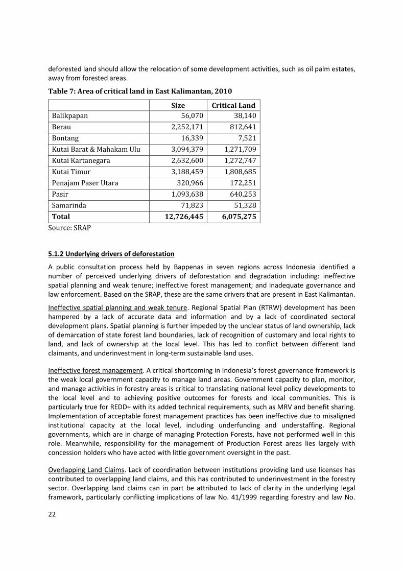
22
deforested land should allow the relocation of some development activities, such as oil palm estates, away from forested areas.
Table 7: Area of critical land in East Kalimantan, 2010
Size Critical Land
Balikpapan 56,070 38,140
Berau 2,252,171 812,641
Bontang 16,339 7,521
Kutai Barat & Mahakam Ulu 3,094,379 1,271,709
Kutai Kartanegara 2,632,600 1,272,747
Kutai Timur 3,188,459 1,808,685
Penajam Paser Utara 320,966 172,251
Pasir 1,093,638 640,253
Samarinda 71,823 51,328
Total 12,726,445 6,075,275
Source: SRAP
5.1.2 Underlying drivers of deforestation
A public consultation process held by Bappenas in seven regions across Indonesia identified a number of perceived underlying drivers of deforestation and degradation including: ineffective spatial planning and weak tenure; ineffective forest management; and inadequate governance and law enforcement. Based on the SRAP, these are the same drivers that are present in East Kalimantan.
Ineffective spatial planning and weak tenure. Regional Spatial Plan (RTRW) development has been hampered by a lack of accurate data and information and by a lack of coordinated sectoral development plans. Spatial planning is further impeded by the unclear status of land ownership, lack of demarcation of state forest land boundaries, lack of recognition of customary and local rights to land, and lack of ownership at the local level. This has led to conflict between different land claimants, and underinvestment in long-term sustainable land uses.
Ineffective forest management. A critical shortcoming in Indonesia’s forest governance framework is the weak local government capacity to manage land areas. Government capacity to plan, monitor, and manage activities in forestry areas is critical to translating national level policy developments to the local level and to achieving positive outcomes for forests and local communities. This is particularly true for REDD+ with its added technical requirements, such as MRV and benefit sharing. Implementation of acceptable forest management practices has been ineffective due to misaligned institutional capacity at the local level, including underfunding and understaffing. Regional governments, which are in charge of managing Protection Forests, have not performed well in this role. Meanwhile, responsibility for the management of Production Forest areas lies largely with concession holders who have acted with little government oversight in the past.
Overlapping Land Claims. Lack of coordination between institutions providing land use licenses has contributed to overlapping land claims, and this has contributed to underinvestment in the forestry sector. Overlapping land claims can in part be attributed to lack of clarity in the underlying legal framework, particularly conflicting implications of law No. 41/1999 regarding forestry and law No.

23
26/2007 regarding spatial arrangement. Furthermore, different sectoral laws, such as those governing agriculture and mining, need to be aligned and give full consideration to local and forest dependent communities and marginalized groups. Governance issues, including spatial planning, law enforcement, and the tenure framework are key factors leading to significant environmental and social impacts. According to the National Forestry Plan (RKTN), up to 15% of the forest estate cannot be effectively used due to ill-defined land use rights and conflicting claims.
5.1.3 Policies and trends to reduce deforestation and forest degradation
Indonesia is currently undergoing a fundamental reform in forest governance, with the establishment of Forest Management Units (Kesatuan Pemangkuan Hutan, or KPH) at the district level. Complementing this, are reforms related to spatial planning and land rights.
KPH. The introduction of Forest Management Units (KPHs) is intended to improve and further decentralize forest management, increase accountability over forest outcomes, improve local stakeholder involvement, and potentially increase transparency. Prior to the reformasi period, the administration of Indonesia’s Forest estate was under the domain of the central Ministry of Forestry (MoFr). As part of the general decentralization process, local forestry agencies- Dinas Kehutanan (Dinas)- were placed under the jurisdiction of district and provincial governments. The Dinas carry out mainly administrative tasks, but they lack the mandate and capacity for effective resource management and law enforcement. The KPH program divides state forest land into discrete area units to be managed by dedicated local institutions that are staffed by forestry professionals. A countrywide KPH system is firmly anchored in the forestry legal framework and in forestry development plans.
While forest concession licenses will still be issued by the central Ministry of Forestry, the KPH will be responsible for developing management plans, for overseeing license holders, and for monitoring land use activities, particularly in open access areas not under license. Importantly, KPHs will be part of local government structures, strengthening decentralized forest governance. By placing forestry professionals at the local and field levels, KPHs will facilitate better law enforcement, improved outreach to local communities, and more structured and localized approaches to addressing land based conflicts and improving local people's access to forests.
East Kalimantan’s forest estate is divided among 20 forest management units (KPH), of which twelve were established by a ministerial decree (SK) and two were active in 2015. The plan is for the remainder to be established by 2020.
Table 8: Planned and existing forest management units (KPH) in East Kalimantan
Unit Name of KPH Area Type of
KPH District/City Status
1 XXII - 658,321 KPHL Kutai Barat
2 XXX HL Sungai Wain 14,782 KPHL Balikpapan
3 XII Berau Barat 786,019 KPHP Berau Operational
4 XIV - 322,953 KPHP Berau
5 XV - 362,417 KPHP Berau
6 XVI - 193,145 KPHP Berau
7 XVII - 263,350 KPHP Kutai Timur
8 XVIII - 707,486 KPHP Kutai Timur
9 XIX - 963,824 KPHP Kutai Timur

24
Unit Name of KPH Area Type of
KPH District/City Status
10 XXIII - 213,244 KPHP Kutai Barat
11 XXIV - 559,712 KPHP Kutai Barat
12 XXV - 451,109 KPHP Kutai Barat
13 XXVI Sub DAS Belayan
1,033,138 KPHP Kutai Kartanegara
Operational
14 XXVIII Kebun Raya Samarinda
299 KPHP Samarinda
15 XXIX Delta Mahakam 112,984 KPHP Kutai Kartanegara Operational
16 XXXIII Telake 275,832 KPHP Paser Operational
17 XXXIV Kendilo 142,421 KPHP Paser Operational
18 XXVII Santan 269,489 KPHP Kukar, Kutim, Bontang
Operational
19 XXXI Meratus 387,749 KPHP PPU, Kubar, Kukar Operational
20 XXXII Bongan 421,743 KPHP PPU, Paser, Kubar Operational
TOTAL
8,140,017
Source: Decree of the Minister of Forestry Number: SK.674/Menhut-II/2011 dated 1 December 2011
Land rights reforms and the “one map” initiative. Two recent constitutional court rulings on the delineation of the Forest estate provide a window for significant acceleration of forest tenure reform. While the previous definition of the Forest estate included areas that had been “designated and/or gazetted” as such, a constitutional court decision in 2011 (MK 45) ruled that the definition includes only areas that have been both designated and gazetted. While the court ruling is unlikely to affect previous decisions on land allocation, it does create significant space for the negotiation of land use between the Ministry of Forestry, district governments, and local communities on areas of the Forest estate that have not yet been gazetted. As less than 15 million hectares had been gazetted by 2011, this includes the majority of the Forest estate. In May 2013, the constitutional court issued a landmark ruling (MK 35) that excludes adat forests from the Forest estate.
Another positive development is what is generally referred to as the “One Map Policy”. This effort is made by the provincial government to synergize maps used by different agencies and levels of government. This measure is expected to help improve data quality and efficiency in data collection and reporting as well as ensuring safeguards. In addition, the Government of Indonesia is developing a national cadastre and continues the delineation and demarcation of land to be designated as state forest areas (Forest Areas).
East Kalimantan’s government has demonstrated a strong commitment to improving the management and supervision of forest and land-based licensing through, for example, issuing a number of key regulations in 2015 (Regulation of Governor No. 22 in 2011 and Regulation of Governor No. 17 of 2015).
25
5.2 Assessment of the major barriers to REDD+
Please describe the major barriers that are currently preventing the drivers from being addressed, and/or preventing conservation and carbon stock enhancement from occurring.
A number of the underlying drivers of deforestation discussed above also present barriers to the implementation of policies, including those that are linked to REDD+. Stronger governance will be critical to the successful implementation of REDD+. Complex and overlapping regulations related to land use licensing and management contribute to investment costs, impacting the investment climate for sustainable land use. The rapid changes in laws and regulations are also a cause of uncertainty at the site level. While there are efforts underway to improve the problem, the lack of clear land rights also creates a challenge for the development of Benefit Sharing Plans and this will be addressed during program design.
In some cases, the benefits associated with deforestation outweigh the incentives that REDD+ payments can provide. Where deforestation occurs illegally, law enforcement would be an effective strategy for REDD+. However, REDD+ funding alone may not be able to compete with the private economic benefits of, for example, legally converting forest to oil palm plantations or mining sites. Also some deforestation, such as that associated with roads and settlements, is an inevitable consequence of East Kalimantan’s development plans.
5.3 Description and justification of planned and ongoing activities under the proposed ER Program
Please describe the proposed activities and policy interventions under the proposed ER Program, including those related to governance, and justify how these activities will address the drivers and underlying causes of deforestation and forest degradation and/or support carbon stock enhancement trends, to help overcome the barriers identified above (i.e., how will the ER Program contribute to the efforts of reversing current less sustainable resource use and/or policy patterns?)
The activities of the ER Program will be aligned with East Kalimantan’s policies and plans, including the SRAP, the RAD GRK, and the Medium Term Development Plan. The ER Program will support ongoing reforms that aim to address underlying drivers of deforestation and will also include activities that target the main sectors and agents associated with land-based GHG emissions. The ER program will support underlying reforms specifically in the areas of forest governance and spatial planning. Further, the program will build on the resulting opportunities for implementing ER activities, in particular through Forest Management Units (KPH). The ER Program will include activities that seek to empower communities within forest management and forest protection. Activities in Berau and Kutai Barat districts will build on ongoing programs in the area, while activities and projects in the other districts will be identified during the program design phase.
5.3.1 Program level activities
Support for and through KPH
Most KPH institutions in East Kalimantan are still in the pre-operational phase (Table 7, above) and there is an opportunity to support the development of institutional models that are compatible with international standards for good forest governance and REDD+. Institutional strengthening will be aimed at community-focused investments to enhance the enabling conditions for sustainable land use and REDD+ project implementation. Activities will support KPHs and other subnational

26
institutions in improving local conditions for REDD+ implementation, in particular in relation to participatory planning, spatial planning, and community outreach and related management and business plan development. By supporting KPH institutions during the initial phase, the ER Program can provide key inputs to institutional design as well as to forest management and business plans, which will determine forestry practices beyond the lifetime of the Carbon Fund program.
Private sector engagement and licensing processes: Mining, estate crops, and logging concessions
The ER Program will reduce emissions in the mining, logging, and estate crops sectors by promoting improved forest governance, and by supporting improved management practices in each of the sectors:
The ER Program will work with palm oil, mining, and forestry companies to support them in adopting sustainability certification schemes and best management practices that lead to reduced deforestation.
Recent analysis indicates that the emissions from selective logging can be significantly reduced by adopting RIL practices. To this end, the ER Program will seek opportunities to support logging concessions in adopting SFM certification and in applying RIL techniques.
In addition, the Program will seek to identify areas of degraded land with the potential for development that could be used in land swaps for plantation development.
The Program will also support the identification and protection of HCV areas within concessions.
Community empowerment and community forestry
Community empowerment will be a key feature of activities related to the above sectors. Further, the program will seek to:
Promote livelihood activities such as community forestry schemes and non-timber forest product harvesting
Facilitate partnerships between local people and companies in the palm oil and forestry sectors.
Promote CSR programs for community empowerment.
Provide capacity building for local communities to promote increased community participation.
Peat land and fire
The extent and associated damage of Indonesia’s 2015 fires have underscored the need for addressing this issue and the ER Program will seek to support related efforts in East Kalimantan. This may include the following:
Protection and rehabilitation of peat land areas
Support for institutional arrangement for fire monitoring and control
Development of infrastructure and facilities for fire control
Establishment of community firefighter groups
Capacity building and other support for non-burning land clearing methods

27
Table 9: Types of ER activities by sector/source
Sector/Source Types of ER Activities
Mining Private sector engagement, support for BMPs, certification, land swaps, smallholder support, support for improved licensing and spatial planning Estate Crops
Forestry Improved forest governance through KPHs, support for RIL, improved licensing and spatial planning, support for SFM and HCV conservation
Fire Protection and rehabilitation of peat land areas, support for institutional arrangements for fire monitoring and control, development of infrastructure and facilities for fire control, establishment of community firefighter groups, capacity building and other support for non-burning land clearing methods, community engagement, peat protection and rehabilitation
Encroachment Improved forest governance through KPHs, support for alternative livelihoods, community forestry, outreach
Planned Development
No specific activities
5.3.2 Activities in Berau
ER activities in Berau will mainly be carried out as part of The Berau Forest Carbon Program (BFCP). The BFCP is a partnership of the district, provincial and national governments, with participation and support from local communities, The Nature Conservancy, FORCLIME, other local and national NGOs, the private sector, and universities. The program is an integrated, district-scale, low-carbon development strategy to create sustainable economic growth while protecting forests, and critical watersheds. The BFCP was declared a district-scale REDD+ pilot in January 2010 by the Ministry of Forestry.
The program aims to reduce carbon emissions in the district through multiple strategies including community management of forests, reduced impact logging, improved siting of oil palm plantations, and enhanced management of protection forest areas. The program is currently establishing district-wide enabling conditions for REDD+, including improved land use planning, policy reforms at local and national levels, and engagement of a broad range of stakeholders in the program. The Berau Program is the first REDD+ program in Indonesia to span an entire political jurisdiction, making it possible to systematically address the drivers of land use change and generate lessons for national REDD+ programs.
Future opportunities that would be part of the ER Program in Berau include:
Developing and testing performance incentives for natural forest logging concessions that implement Reduced Impact Logging practices
54% of Berau land (1.2 million hectares) was designated as production forests and limited production forests on which natural forest concessions (HPH) undertake selective logging. Between 2000 and 2010, there were at least 20 active HPHs in Berau that harvested 9,344 hectares of natural forest per year or around 297,766 m3 of log per year. Associated emissions can be reduced by enhancing the capacity of the HPHs through training programs and providing suitable incentive schemes.
Engaging communities in forest management and balancing protection-production at the village level through the implementation of SIGAP approach.

28
TNC developed an approach called SIGAP and has been engaging 2 villages in Berau as SIGAP model villages. SIGAP in Indonesian signifies inspirational community actions to effect change. This approach addresses the challenges villages face by helping to empower them to better protect and manage their forests and address their development needs by:
o Communicating a long-term vision to protect community land and support the growth of the village;
o Formulating green development plans that integrate communities’ land use, village infrastructure development, natural resource management and livelihood development needs;
o Establishing collaborative forest arrangements with private companies to ensure protection of and access to important natural and cultural resources (e.g., clean water, hunting grounds, sacred graves);
o Securing legal management rights over forests that will protect communities’ abilities to sustain important forest resources over the long-term; and
o Accessing financial support to implement agreed upon natural resource management activities (e.g., patrolling the forest to prevent poaching, replanting degraded areas) and green livelihood activities (e.g., selling forest products, ecotourism), while limiting activities that degrade forests.
An additional 24 villages in Berau have been implementing the SIGAP approach with technical support and facilitation by local and national NGOs, who received funding from the debt-for-nature swap for Kalimantan.
Through SIGAP processes, interested communities can be supported to secure management rights over forests, in the forms of customary forest (hutan adat), village forest (hutan desa), partnership forest (hutan kemitraan) or community forestry (hutan kemasyarakatan). Merabu Village has obtained a 35-year management right over 8,245 hectare of forest and became the first Hutan Desa in Merabu. Berau has also proposed 50,119 hectares of forests that are potentially managed by community as described in the Social Forestry Indicative Maps (PIAPS).
As a part of the SIGAP process, an incentive agreement is developed with villagers to control or reduce carbon emissions through activities such as limiting slash and burn agriculture and forest patrolling against encroachment. Based on the performance of villagers in undertaking these activities, incentives will be disbursed. The incentives can be used by villagers to develop green livelihood activities and capacity building.
Developing a sustainable palm oil program in Berau, including support for improved land-use planning, implementation of best practices, and influencing ongoing national and international policy dialogues around sustainable oil palm.
The majority (64%) of net emissions in Berau between 2000 and 2010 was due to forest loss outside of the forest estate (Area Penggunaan Lain, APL). About half of those emissions occurred in areas with legal permits for conversion.
The BMUB-funded Sustainable Palm Oil project, implemented by TNC, GIZ and CPI, aims to demonstrate how palm oil development can provide local and national economic development benefits without causing high carbon emissions and other environmental impacts. This program will ensure that: i) Only environmentally and socially suitable land is developed for palm oil, ii) both production and protection areas are managed effectively, and iii) incentives and multi-stakeholder agreements ensure durable results.

29
The project will develop, test and apply new tools, incentives and policy frameworks that will increase the sustainability of palm oil agriculture. The activities will include: o Develop land use plans and a spatial data management system to show where on the
landscape palm oil plantations will have the least impact and to guide palm oil licensing to suitable areas.
o Produce mitigation planning tools to help palm oil companies compensate for lost forestlands.
o Develop tools to help companies go beyond legal sustainability requirements, progressing toward international sustainability certifications and deforestation-free production over time.
o Help communities protect their traditional lands by encouraging governments to recognize village development plans and helping communities negotiate with palm oil companies.
o Make recommendations to the provincial and district government on what combinations of policies and incentives could support more profitable, sustainable business models for palm oil while protecting forestland at risk of conversion. Participatory High Conservation Value of Forest mapping is one of the keys in protecting forests and ensuring sustainability.
Improving management of protection forest for emissions reduction and carbon sequestration
Berau has put more than 360,000 ha or 16% of its total area under protection. Emissions from these protection forests (hutan lindung) were quite low, but they were still significant in the perspective of climate change. The management of protection forest will reduce encroachment and ensure the forests will continue providing environmental services to surrounding populations.
BFCP promotes the establishment of an integrated management plan for all protection forests in Berau for carbon sequestration, conservation of biodiversity, and the provision of environmental services. Conservation efforts in protection forests also include special ecosystems such as karst, which has high social, cultural and environmental conservation values. Provision of management rights through Hutan Desa will be used to engage surrounding villages in the protection and management of protection forests in Berau.
Improving forest governance at site level by strengthening Forest Management Unit (KPH).
Forest areas in Berau are divided into 4 KPHs. One KPH has been established, i.e. KPH Berau Barat. KPH roles are key in enhancing sustainable forest management by companies, improving management of protection forests, and improving community-company collaboration in forest management. Supports from donors and other initiatives will be coordinated by KPH allowing an integrated and effective management of forest at site level. KPH can also play a role in coordinating Carbon Fund incentive mechanism at site level. To enable this, MRV system should also be built at site level. KPH Berau Barat has been operational with technical support from TNC, GIZ, and other institutions.
5.3.3 Activities in Kutai Barat and Mahakam Ulu
The program in Kutai Barat and Mahakam Ulu started in 2008 with research conducted by the local government, WWF, I-REDD, and local universities. This research covered all modules of REDD+ from MRV and REL development to community empowerment. Some of the project results include the establishment of customary forests (hutan adat), micro-hydro power generation, and the draft of the revised spatial plan.

30
In 2014 the project completed the Green Development Action Plan for Kutai Barat and Mahakam Ulu, which is endorsed by both district governments. Expected ER Activities are as follows:
1. Revision of spatial plans to integrate low carbon development and REDD+ options. The recent separation of Mahakam from Kutai Barat presents a window of opportunity for improved spatial planning.
2. Improving best practice management of forest concessions using certification schemes (SVLK, PHPL, FSC, Reduced Impact Logging RIL, HCV).
3. Developing models and implementing land swaps for oil palm estates from high carbon and conservation to low carbon and conservation values and promoting palm oil certification (Indonesian Sustainable Palm Oil or ISPO, and the Roundtable for Sustainable Palm Oil or RSPO).
4. Strengthening village planning, implementation, and monitoring to promote sustainable rural development. This includes recognition of customary land tenure and rights and sustainable forest management and agroforestry to support communities’ livelihoods and culture.
5. Strengthening community based businesses related to agricultural commodities such as cacao agroforestry, coffee, agarwood as well as other non timber forest products.
6. Maintaining carbon and High Conservation Values (HCV) in timber plantations through improved management, revision of spatial plans, agreements with companies, HCV monitoring, improved management of HCVF, and training of local government in HCVF monitoring.
7. Improving the monitoring system for MRV for integration into subnational and national MRV and registry systems.
8. Protection and restoration of forests in mining areas and other degraded land.
9. In addition, WWF is in the preparation phase to work on the management of the Mahakam River watershed as well as the peat area between Kutai Barat and Kutai Karta Negara (around 250,000 hectares of peat). This includes baseline development, development of management options, and strengthening stakeholder capacity.
5.3.4 Activities in Kutai Kartanegara (Kukar)
Kukar District has established a Working Group on Forest - Land Governance and REDD+, and issued a Decree of Regent No. 590/526/001/A.Ptn/2013 on the Appointment of Peatland Conservation area of 72 766 hectares in Sub districts of Muara Kaman, Kehonah, Muara Wis and Muara Muntai. Together with BIOMA Foundation, the District Government of Kutai Kartanegara has been implementing the Programs of Peat Conservation in Central Mahakam that include 29 villages and 5 districts. Programs that have been implemented include:
a. Awareness raising in environmental conservation at village level b. Identification of data and information on economic activity of community c. Preparation of peatland conservation management planning by the community and
facilitation of village boundaries d. Capacity building of community in area management, mapping and improving the local
economy.

31
Kutai Kartanegara District Government has also conducted evaluation to the license of estate plantations on peatland, and did not extend the license of some estate companies in peat areas.
The Programs of Central Mahakam Peat Conservation have been conducted jointly with the communities, including through:
a. Institutional strengthening and village planning (RPJMDesa) towards the Climate Village to support peat conservation efforts
b. Increasing the alternative economy of community that correspond to low-carbon development, including through the processing of fishery products, reduce impact logging and peat ecotourism.
c. Strengthening the community institution to support the program of "zero burning".
5.3.5 Activities in Paser
Paser is a district that has declared itself as a conservation district. As one of its commitment, Paser District has developed a Biodiversity Park in the area of 1,067 hectares in the village of Modang, Kuaro Sub District, legalised through Paser Regent Decree No. 522.51 / KEP-123/2015 dated on February 26, 2015, as well as the management of Petangis Forest Park, a former mining concession area, which is currently under the management of district technical unit of forest park (UPTD Tahura) under the structure of the District Forestry Office. Forest park of Petangis was originally set through the Paser Regent Decree No. 522.74 / Kep-100/2010 on Designation of former Forest Areas of PT. BHP KCL in Petangis, Batu Engau subdistrict as Forest Park, which was later confirmed by the decree of Minister of Forestry.
Paser has the program of estate revitalization, as well as ensuring high conservation value areas in the licensing of oil palm estates. Paser District Government has also established a Working Group on REDD +, as a coordinative body of stakeholders in the implementation of REDD + in the District.
6. STAKEHOLDER INFORMATION SHARING, CONSULTATION, AND PARTICIPATION
6.1 Stakeholder engagement to date on the proposed ER Program
Please describe how key stakeholder groups have been involved in designing the proposed ER Program, and summarize issues raised by stakeholders, how these issues have been addressed in the ER Program to date, and potential next steps to address them
The preparation of the ER Program began in early 2014 with the involvement of multiple stakeholders. An initial “Meeting of the Stakeholders in the Preparation of Proposal of FCPF Carbon Fund Emissions Reduction Program Idea Note (ER-PIN)” was held in Bogor on 17 April 2014. This meeting involved key REDD+ stakeholders from the national and regional levels.7 This was followed
7 Participants included: the REDD+ Agency, the World Bank, TNC, FORCLIME-GIZ, CIFOR, ICRAF, Director of IPSDH, Director General of Planning, Director of PJLKKHL, Director General of PHKA, DNPI, the Planning

32
by discussions concerning the selection of participating districts on 22, 29, and 30 April 2014, which led to the initial selection of seven districts across four provinces.8 On 9 - 10 May 2014 a workshop was held with the seven districts to discuss the ER Program. Puspijak with the support of the REDD+ Agency hosted a public communication with stakeholders on 19 May 2014 in Jakarta. The purpose of this meeting with national level stakeholders was to communicate, discuss and provide insights into the ER-PIN process.
Following the CF’s recommendation in October 2014 to consolidate the ER Program area, meetings among Puspijak, the REDD+ Agency, the World Bank, TNC, WWF, Pustanling and several other organizations were held to discuss the revised location. Based on technical and political considerations, East Kalimantan was selected. A meeting with stakeholders was held on 27-28 October 2015 in Samarinda, and a public communication was held on 20 November 2015 in Balikpapan. These meetings were followed by a public communication at the national level held on 27 November 2015 in Jakarta which was attended by over 50 people, from the government, civil society organizations, private sectors, and international organizations.
The process of drafting the revised ER-PIN began with a meeting with the Governor of East Kalimantan on 9 October 2015. At the meeting, the Governor of East Kalimantan, Dr. Awang Faroek, expressed his full support to the preparation of the ER program within the framework of the Carbon Fund in East Kalimantan and appointed the Regional Council on Climate Change (DDPI) as the focal point for the ER Program.
The proposed program is based on East Kalimantan’s REDD+ strategy documents (RAD GRK and SRAP) and on related reforms that have been built on strong stakeholder engagement and outreach activities. The SRAP and RAD GRK were developed through consultation processes, reaching out to communities, NGOs, universities and the government (provincial and district). The existing programs in Kutai Barat/Mahakam Ulu and Berau have included significant consultation processes with stakeholders including customary communities. In addition, the FCPF Readiness Program has sponsored numerous outreach events both at the national and subnational levels on REDD+ in general. Outreach and communication material from various programs and development partners have been published on-line, in print, and through workshops, trainings, and other means.
Bureau, Mulawarman University, Palangkaraya University, researchers from Puspijak, Managing Director PT. Rimba Makmur Utama, BAPPENAS, Climate Change Working Group of the Ministry of Forestry, WWF, IAFCP, Center for Foreign Cooperation of the Ministry of Forestry and representatives of INCAS team.
8 The seven potential districts, were: (1) Donggala District, Central Sulawesi Province; (2) Toli-Toli District, Central Sulawesi Province; (3) Berau District, East Kalimantan Province; (4) Kutai Barat District, East Kalimantan Province; (5) Kapuas District, Central Kalimantan Province; (6) Merangin District, Jambi Province; and (7) Bungo District, Jambi Province.

33
6.2 Planned outreach and consultation process
Please describe how relevant stakeholder groups will participate in further design and implementation of the proposed ER Program and how free, prior and informed consultation leading to broad community support for the ER Program including the benefit-sharing arrangement will be ensured. Please describe how this process will respect the knowledge and rights of indigenous peoples and local communities, by taking into account relevant international obligations, national circumstances and laws.
The inclusion and involvement of stakeholders is one of the pillars of the National REDD+ Strategy and hence of the proposed ER Program. During the program design phase, the program partners under the leadership of the Ministry of Environment and Forestry will engage and consult a broad range of stakeholders at the community, district, provincial, and national levels at all stages of design. The process will be robust, inclusive, transparent and participatory in accordance with high standards of public consultation. Particular attention will be given to customary peoples and local communities, to gender issues, and to the utilization of local knowledge and techniques, where appropriate. Besides covering the design of ER activities, the consultation and outreach process will be used to design benefit sharing arrangements, and the safeguards, REL and MRV systems.
7. OPERATIONAL AND FINANCIAL PLANNING
7.1 Institutional arrangements
Please describe the governance arrangements anticipated or in place to manage the proposed ER Program (committee, task force), and the institutional arrangements among ER Program stakeholders (i.e., who participates in this ER Program, and how, including the roles of civil society organizations and forest dependent communities).
The preliminary institutional arrangements proposed for this ER Program are designed to: (1) facilitate coordination among stakeholders; (2) ensure the effectiveness and efficiency of the benefit sharing mechanism; (3) ensure the participation of each stakeholder; (4) conform to the national REDD+ program; and (5) facilitate the coordination of the program.
The main stakeholders at the national level and their roles are as follows:
1. The Ministry of Environment and Forestry will be the main management agency of the ER Program and will coordinate the implementation of ER Activities in East Kalimantan. The Ministry will also provide limited technical assistance for preparing the province to implement the ER program, in part through the FCPF Readiness Fund.
2. Bappenas will support the ER Program and incorporate it into the national program for GHG emission reduction to support low carbon emission development. Bappenas can also monitor the implementation of support for KPH development.

34
3. The Ministry of Finance will help design the legal framework for the benefit sharing mechanism. The Ministry of Finance is also important for the development of incentive mechanisms for the provincial and district governments.
4. The Ministry of Home Affairs may provide direction to regional governments related to the administration and operation of the balance fund at the regional level and may play a critical role in benefit sharing, through its administration of community development programs (PNPM) and funds.
5. The National Forestry Council (Dewan Kehutanan Nasional) is a representative of civil society organizations and non-government organizations working in forestry area and will support the implementation of the ER Program by promoting the inclusion of local people and other affected parties.
The main stakeholders at the provincial and district levels and their roles are as follows:
1. The Regional Council on Climate Change will be the focal point and coordinator of the implementation of the ER Program in East Kalimantan.
2. Bappeda of East Kalimantan will support the ER Program and incorporate the program into the regional programs for GHG emission reductions to support the development of low carbon emissions in East Kalimantan.
3. The Provincial Environmental Agency will support the implementation of ER to perform monitoring and reporting of emissions reduction
4. The Provincial Forestry Office will provide support for the ER Program and incorporate it into a sustainable forest management plan at the provincial level, including management of FMU. In this case the FMU will coordinate implementation activities at the site level.
5. District/City Bappeda will be responsible for ensuring the ER Program is implemented and monitored and eventually integrated into the provincial REDD+ programs.
6. The Plantation Office of East Kalimantan Province will support the implementation of emission reductions in the development of plantations, especially oil palm plantations
7. The Mining and Energy Office will support the implementation of ER Program in the mining area
8. Village institutions will support the implementation of the ER Program and the participation of the local community in the program
9. Indigenous peoples and local communities will participate in the implementation of the Program and will be the main beneficiaries of the investment and incentives
10. Local NGOs will support the FMU and the local governments in preparing and implementing the ER Program, through technical and financial support
11. Program partners, at national and international levels, NGOs, will manage, fund and coordinate the ER activities at the provincial/district/FMU in collaboration with the provincial and district/city governments.
CF activities, performance and results will be reported to a Steering Committee. The Steering Committee will be at the Secretariat General level, will be chaired by the Ministry of Environment and Forestry, and will be composed of the principal agencies involved. These include the Director General (DG) of FORDIA, The DG of Climate Change, Ministry of Finance, Ministry of Home Affairs, Bappenas, and the Government of East Kalimantan. The Steering Committee will also include representation from non-government stakeholders including civil society and representatives of indigenous groups. The World Bank and selected partner agencies will be given observer status. Steering Committee meetings will be held every 6 months to evaluate activities and progress. Technical coordination meetings, organized by the Ministry of Environment and Forestry, will be held 2-3 times per year.

35
7.2 Linking institutional arrangements to national REDD+ implementation framework
Please describe how the institutional arrangements for the proposed ER Program fit within the national REDD+ implementation framework.
The proposed institutional arrangements are aligned with Indonesia’s REDD+ framework, which provides a coordinating role to the center, with implementation at the subnational level. The role of the Ministry of Environment and Forestry in the ER program reflects its mandate to assist the President in the coordination, planning, management, monitoring, and supervision of REDD+ activities. The Ministry, in accordance with Law No 5/1990, Law No. 41/1999, and Law No. 32/2009, has the legitimacy and capacity to manage and implement REDD+ programs. Further, the ER Program closely involves the provincial government and supporting agencies, which will have an important role in implementing the Indonesian approach to REDD+.
7.3 Capacity of the agencies and organizations involved in implementing the proposed ER Program
Please discuss how the partner agencies and organizations identified in section 3.1 have the capacity (both technical and financial) to implement the proposed ER Program
The Ministry of Environment and Forestry will be the primary managing agency and, together with its partners, has the financial and technical capacity to implement the ER Program. MoEF manages a significant budget and has experience in managing grants from international donors. For example, MoEF’s Research and Development Center for Socio-Economics, Policy, and Climate Change (P3SEKPI) is currently successfully implementing the FCPF Readiness program. MoEF’s Directorate General of Climate Change serves as the National Focal Point for the Conference of Parties (COP) of the UNFCCC to effectively facilitate ongoing relevant programs and processes being implemented by variety of government sectors and stakeholders.
The Regional Council on Climate Change in East Kalimantan is a key partner in the implementation of the ER Program. DDPI is a multi-stakeholder organization that has coordinated the planning and implementation of low emission development in the province. It has significant experience (as well as operational infrastructure) in the management of donor funding.
The National Forestry Council (DKN) is a multi-stakeholder representative body established to arrange consultative process and provide policy-related advice to the National Government. DKN was established in the Fourth Indonesia Forestry Congress in 2006. DKN is a constituent-based organization and comprises five chambers designed to represent main stakeholder groups in the forestry sector: the government, society, business, academics, and NGOs (including the representatives of ‘indigenous organizations’). Widely recognized and respected, the DKN has the task to assist the formulation of effective policies through increased communication among stakeholders, increase the agreements on important forestry issues, and improve the dissemination of information on the performance of the forestry sector.
The design phase of ER Program will identify strong partners at the provincial level. Civil society organizations with experience in collaborating with local communities and local governments in forest law enforcement and governance (FLEG), forest and land tenure reform, and degraded lands development, will be important partners in providing technical assistance and implementing ER

36
activities. Implementing partners will be selected based on their capacity to work across sectors, to work consultatively with communities, and to successfully implement project activities.
7.4 Next steps to finalize the proposed ER Program implementation design (REL/FRL, ER Program monitoring system, financing, governance, etc.). Provide a rough timeline for these steps.
Upon selection of the proposed program into the Carbon Fund pipeline (expect in June 2016) and the subsequent signing of a Letter of Intent, the involved government and non-government partners will immediately transition into a program preparation phase (starting in July 2016). Additional funding provided through FCPF Readiness Fund (USD 5 million) will support a dedicated program preparation team, technical design and implementation planning work, capacity building and consultations. A general road map for the preparation of the program has been developed. According to this road map, a draft ER-PD would be prepared by June 2017 for review by the Technical Advisory Panel and a final ER-PD by October 2017 for submission to the Carbon Fund meeting in late 2017.
Through the preparation of the ER-PIN, important areas of work have been identified and will be addressed through focused technical design and implementation planning work going forward. Key work areas include:
The finalization of a Reference Level that is consistent with the Methodological Framework and adequately captures key drivers and interventions of the program in East Kalimantan. An important area of technical work will focus on forest fires, which are an important driver of forest loss but have been difficult to translate into reliable estimates of emissions due to the high degree of year-to-year variability (the effect of peat fires in East Kalimantan is less pronounced, but will be further analyzed during the preparation phase).
The development and implementation of a forest monitoring and MRV approach for East Kalimantan and associated capacity building at the provincial level. At the same time, the national framework for MRV is expected to be advanced and finalized to allow for observations and results to be captured and accounted for in a national system.
Detailed investment and implementation planning. The program preparation phase will include the development of detailed, prioritized and costed investments and the development of respective institutional strengthening and capacity building interventions at the provincial and district level. A key focus will be to mobilize the necessary investments for implementation from government, private sector and other sources.
The identification of potential social and environmental risks associated with program interventions and the development of mitigations actions. The necessary safeguards work will build on the Environmental and Social Management Framework developed under the FCPF Readiness grant. Also, a Feedback and Grievance Redress Mechanism will have to be developed.
The design and adoption of a benefits sharing plan. This plan nests within a national framework which is expected to be advanced and finalized in the near-term.
Technical work and analysis to inform the program design and meet the requirements of the Methodological framework, including assessment on land and resource tenure, emission displacement (leakage) and non-permanence (reversal) risk, statistical accuracy of emissions estimates and sampling design for permanent sampling plots.

37
Analysis to facilitate policy changes at the national level and provincial, including the development of a master plan for managing climate change in East Kalimantan.
Action Responsible Entity Expected Date
ER-PIN Submitted GOI/MOEF April 2016
ER-PIN Reviewed and Selected into Pipeline
CF Participants and WB May/June 2016
Letter of Intent Signed GOI/MOEF and WB August 2016
FCPF R-Package Submitted and Endorsed by FCPF Participants
GOI/MOEF December 2016 (endorsement at PC23)
Draft ER Program Document Prepared MOEF with technical support from WB
June 2017
ER Program Document Submitted GOI/MOEF October 2017
ER Program Document Reviewed and Selected
CF Participants and WB December 2017
ERPA Negotiation CF Participants and WB and GOI/MOEF
(approx. 6 months)
ERPA Signed 2018 (18 months after LOI)
Implementation, Verification, Payments
CF Participants and GOI/MOEF
2018- 2024
7.5 Financing plan (in US$ million)
Please describe the financial arrangements of the proposed ER program including potential sources of funding. This should include both short term and long term financing. If the proposed ER program builds on existing projects or programs that are financed through donors or multilateral development banks, provide details of these projects or programs, including their financing timeframe. Use the table in Annex I to provide a summary of the preliminary financial plan
The total cost of the ER Program for the period 2018 to 2024 is estimated at US$ 300 million, including costs of US$ 2.4 million for developing the ER Program. These costs are in addition to ongoing government programs that are linked to the RAD GRK. Program development costs include investment in the MRV system, finalization of the REL, the design of the benefit sharing mechanism and FGRM, ER-PD Development, and analytical work such as land assessments for the Program Area. The more accurate and detailed estimate will be presented in the ER-PD based on a detailed cost assessment of the required interventions and investments in the East Kalimantan.
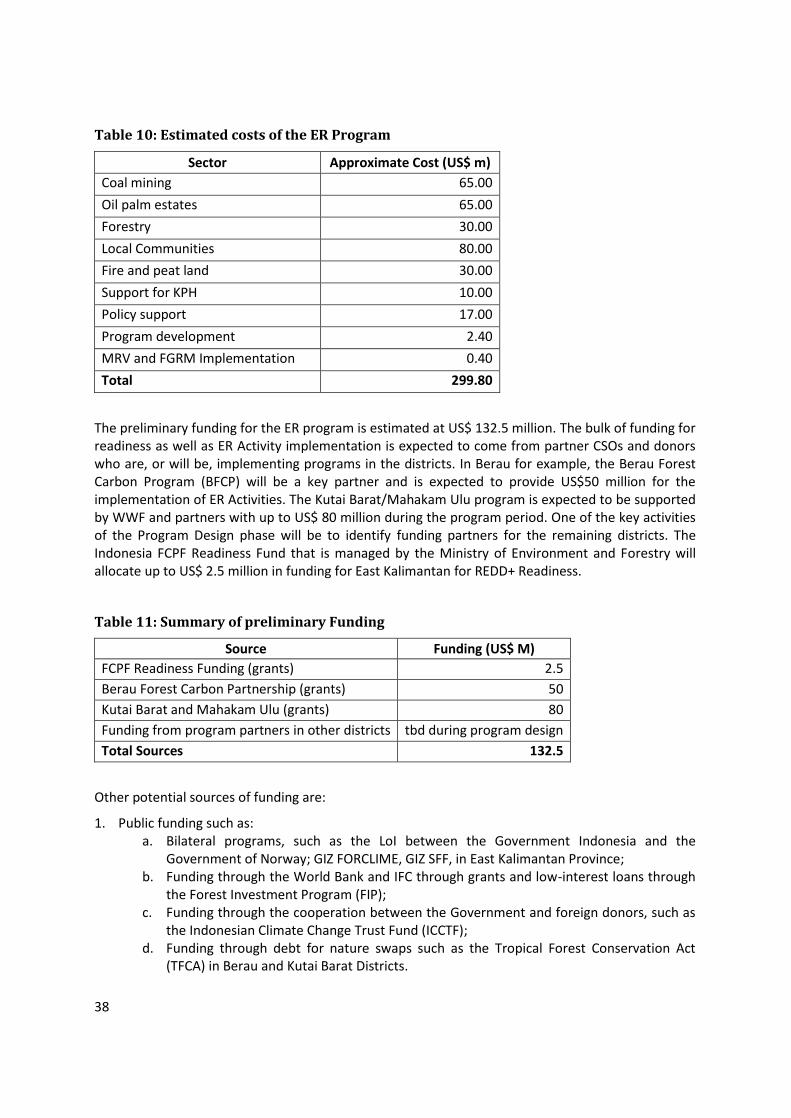
38
Table 10: Estimated costs of the ER Program
Sector Approximate Cost (US$ m)
Coal mining 65.00
Oil palm estates 65.00
Forestry 30.00
Local Communities 80.00
Fire and peat land 30.00
Support for KPH 10.00
Policy support 17.00
Program development 2.40
MRV and FGRM Implementation 0.40
Total 299.80
The preliminary funding for the ER program is estimated at US$ 132.5 million. The bulk of funding for readiness as well as ER Activity implementation is expected to come from partner CSOs and donors who are, or will be, implementing programs in the districts. In Berau for example, the Berau Forest Carbon Program (BFCP) will be a key partner and is expected to provide US$50 million for the implementation of ER Activities. The Kutai Barat/Mahakam Ulu program is expected to be supported by WWF and partners with up to US$ 80 million during the program period. One of the key activities of the Program Design phase will be to identify funding partners for the remaining districts. The Indonesia FCPF Readiness Fund that is managed by the Ministry of Environment and Forestry will allocate up to US$ 2.5 million in funding for East Kalimantan for REDD+ Readiness.
Table 11: Summary of preliminary Funding
Source Funding (US$ M)
FCPF Readiness Funding (grants) 2.5
Berau Forest Carbon Partnership (grants) 50
Kutai Barat and Mahakam Ulu (grants) 80
Funding from program partners in other districts tbd during program design
Total Sources 132.5
Other potential sources of funding are:
1. Public funding such as: a. Bilateral programs, such as the LoI between the Government Indonesia and the
Government of Norway; GIZ FORCLIME, GIZ SFF, in East Kalimantan Province; b. Funding through the World Bank and IFC through grants and low-interest loans through
the Forest Investment Program (FIP); c. Funding through the cooperation between the Government and foreign donors, such as
the Indonesian Climate Change Trust Fund (ICCTF); d. Funding through debt for nature swaps such as the Tropical Forest Conservation Act
(TFCA) in Berau and Kutai Barat Districts.

39
2. Funding from the private sector, such as: a. Funding from the allocation of Corporate Social Responsibilities (CSR) and Community
Development funds devoted to activities related to REDD+; b. Funding from ecosystem restoration activities which are managed by private parties; c. Funding from Environmental Services development activities which are managed by
private parties; d. Funding from investors that are interested in promoting and/or benefiting from REDD+
programs/projects/activities in East Kalimantan;
3. Others funding from donors, institutions, individuals and civil society.
The Financing Plan Summary is in Appendix 2. It should be noted that this is still at a preliminary stage, to be finalized during program design.
8. REFERENCE LEVEL AND EXPECTED EMISSION REDUCTIONS
8.1 Approach for establishing the Reference Emission Level (REL) and/or Forest Reference Level (FRL)
Please briefly describe how the REL/FRL for the proposed ER Program has been or will be established. Describe how the approach for establishing the REL/FRL is consistent with UNFCCC guidance available to date and with the emerging Methodological Framework of the FCPF Carbon Fund, and with the (emerging) national REL/FRL (or with the national approach for establishing the REL/FRL).
The Forest Reference Level (FRL) for the proposed ER Program presented in this ER-PIN uses the same methodology and dataset that is used in Indonesia’s national Forest Reference Emission Level report, which was published in September 2015, and which is consistent with IPCC guidelines. Both use a historical accounting approach that accounts for emissions from deforestation, from forest degradation, and from peatland decomposition from drainage. The FREL includes only gross emissions and does not account for removals by sinks. The estimated preliminary ER Program Reference Level is specific to the ER Program Area (East Kalimantan) and is based on a 15 –year average (1998 to 2012). This reference period is chosen for the purpose of estimating a preliminary RL for the ER-PIN. The principal motivation for this reference period is to capture the longer-term effect of forest fires on forest loss in the East Kalimantan. As noted above, effect of fires were particularly pronounced in the late 1990s as well as in 2015, while the period 2000-2012 had a significantly lower rate of forest loss due to fires. Extreme episodes of fires are partly driven by multi-year cycles of drought caused by the El Nino Southern Oscillation. A ten or twelve-year period does not adequately capture this effect. Going forward, more careful and detailed analysis of the data and multi-year dynamic of emissions, the Reference Period would be chosen to adequately capture the all significant sources of emissions using an approach that is consistent with the intention of the Carbon Fund Methodological Framework. An important consideration will be the quality and accuracy of the underlying data for each of the sources of emissions.
Activity data was generated using MoEF’s wall-to-wall land cover map. The map was produced using visually interpreted Landsat satellite images from the years 1996, 2000, 2003, 2006, 2006, 2011, and 2012. The employed classification produced 23 land cover classes, including six natural forest classes.

40
Additional emission sources in the ER Program FREL that are not included in the national FREL are peat fire and selective logging.
Accounting for emissions from deforestation and degradation
The FREL uses the definition of forest that Indonesia adopted for the Clean Development Mechanism of the Kyoto Protocol, which is an area “spanning more than 0.25 hectares with trees higher than 5 meters at maturity, and a canopy cover of more than 30 percent, or trees able to reach these thresholds in situ”.9 However, in practice, measurement is also a factor of the resolution of the satellite images which have a polygon delineation of 6.25 hectares. Natural forests were classified into six classes based on forest types and degradation or succession level (Table 12). Deforestation is defined as the conversion of natural forest cover into a non-forest land-cover category. Forest degradation is defined as a change from one of the primary forest categories to a secondary forest category. In the period 1996-2012, the average annual deforestation and degradation were 98,526 hectares and 53,769 hectares respectively (Figure 2).
Figure 2: Deforestation and degradation in East Kalimantan during Reference Period
Emissions factors for deforestation and degradation are based on the difference in carbon stock between the new and the previous land cover. The primary source of data used to derive emission factors was the National Forest Inventory (NFI) program - a national program initiated by the Ministry of Forestry in 1989 and supported by the Food and Agriculture Organization of the United Nations (FAO) and the World Bank. From 1989 until 2013, more than 3,900 clusters of sample plots, have been developed and distributed across the country (Ditjen Planologi Kehutanan, 2014). The
9 Forestry Ministerial Decree No 14/2004 on A/R CDM
98,526
53,769
-
50,000
100,000
150,000
200,000
250,000
1996-2000 2000-2003 2003-2006 2006-2009 2009-2011 2011-2012
Deforestation Degradation
Ave. Deforestation:
Ave. Degradation:
ha
ha
Hectares

41
aboveground biomass (AGB) of individual trees in the plots was estimated using allometric models (Chave et al., 2005). Measured carbon stocks of the various forest classes in Kalimantan range from 80 tonnes of carbon per hectare for secondary mangrove forest to 127 tonnes of carbon per hectare for primary dryland forest (Table 12).
Table 12: Carbon stock of forest classes used in the FREL
Forest Class Sample
Plots (N) 95% Conf.
Interval AGB
(t/ha) C Stock (t/ha)
Primary Dryland Forest 333 258.2 - 280.6 269.4 127
Secondary Dryland Forest 608 196.3 - 210.3 203.3 96
Primary Swamp Forest 3 269.2 - 281.9 275.5 129
Secondary Swamp Forest 166 158.6 - 182.5 170.5 80
Primary Mangrove Forest 8 209 - 318.8 263.9 124
Secondary Mangrove Forest
12 134.5 - 244 201.7 95
Source: National Forest Reference Emission Level, GOI 2015
Combining the emissions factors with the data on land use change leads to an average annual emission of 35.3 MtCO2e and 6.1 MtCO2e for deforestation and degradation respectively during the Reference Period (Table 14 in Section 8.2 below).
Accounting for emissions from peat decomposition
The FREL includes emissions from peat decomposition that are associated with a change in drainage pattern when forest cover is removed. Emissions from peat10 drainage depend on the land cover and the land use and range from no emissions for primary forests to 73 tonnes CO2 per hectare per year for plantation forest (Table 13). The FREL calculates emissions from peat decomposition by taking into account the rate of drainage associated with each land classification. The methodology assumes that emissions continue to accumulate after deforestation, until all organic matter has decomposed. The average annual emissions from peat decomposition during the reference period are estimated at 3.2 MtCO2e.
10 Peatland is defined using the Indonesian National Standard (SNI 7925-2013) as an area with an accumulation of partly decomposed organic matter, water saturated, with a carbon content of at least 12% and thickness of the carbon rich layer of at least 50 cm.

42
Table 13: Rates of peatland decomposition associated with land classifications used in the FREL
Source: National Forest Reference Emission Level, GOI 2015
Accounting for emissions from selective logging
A drawback of the current remote sensing approach for measuring forest degradation, is that emissions from selective logging in secondary forests are not captured. This is because the medium resolution satellite imagery, such as that used for the FREL, cannot adequately distinguish between levels of degradation within secondary forest. A study by Griscom et.al (2014) found that selective logging in secondary forest generates approximately 1.5 tC per cubic meter of timber extracted. This is due mostly from secondary damage caused by felling gaps, skidding, and hauling practices. The emissions associated with Reduced Impact Logging (RIL) practices are estimated to be around 40% lower.
It is possible to estimate the emissions from selective logging by estimating the volume of timber logged (differentiating between conventional logging and RIL) and applying the appropriate emissions factor. Official logging data is available for the Reference Period and this can be adjusted with an estimate of unrecorded logging. The methodology will be established during the program design phase. To provide an estimate of the order of magnitude of emissions from selective logging for the purpose of the ER-PIN, the following rough assumptions were made:
Assuming that during the Reference Period, log production in East Kalimantan was approximately 1 million cubic meters per year (Ministry of Forestry, 2013), and that the proportion sourced using RIL was negligible, leads to emissions of 1,000,000 x 3.67 x 1.5 = 5.5 MtCO2e per year.

43
Accounting for above-ground emissions from fire
Fire is known to be an important source of above-ground GHG emissions in East Kalimantan, especially during extreme fire events. A significant source of emissions from fire is the burning of forests and this leads to forest degradation, or in more severe cases, to deforestation, and these sources are captured by the analysis of satellite images. The Reference Period includes 1997/1998, which was an extreme fire year, and this is evident in the higher than average deforestation and emissions levels in that year (see Figure 2 above).
However, it should be noted that the FREL currently does not capture emissions from the burning of above-ground biomass from non-forest land categories, such as brush land and timber plantations. While more analysis will be carried out during the program design phase to estimate these emissions, it is likely that they are lower than the 10% contribution threshold stipulated by the Methodological Framework.
Accounting for emissions from peat fire
Previous national estimates on emissions from peat fires, including the one in the Second National Communication, have attributed a significant share (more than 30%) of total emissions to peat fires. These estimates had a large degree of uncertainty and were based on a map of peat distribution that indicated that there are 20.6 million hectares of peat, while the more recent map from the Ministry of Agriculture shows a peat distribution of only 14.9 million hectares. According to this map, which is also the basis for the peat decomposition estimate in the FREL, East Kalimantan has relatively little peat: 164,450 hectares, which represents 1.1% of the national peat area, while East Kalimantan’s total land area makes up 6.9% of Indonesia.
Estimates of national emissions from peat fires differ substantially. According to a preliminary calculation in the national FREL document, national emissions from peat burning between 2000 and 2012 averaged 27.1 MtCO2e per year. In comparison, the estimate used in Indonesia’s Second National Communication was 470 MtCO2e per year. The discrepancy reflects the difference of methodology used for estimation and the sources of data and references. Using the median of the two estimates (249 MtCO2e) and assuming that East Kalimantan’s contribution is proportional to its share of national peatland (1.1%) leads to a preliminary estimate of 2.7 MtCO2e. However, given the large uncertainties in the measurement of emissions from peat fires, further analysis will need to be conducted during the program-design phase to determine whether the source should be included in the final ER Program FREL.
8.2 Expected REL/FRL for the ER Program
Please provide an estimate of the REL/FRL for the proposed Accounting Area. Even a very preliminary estimate would be helpful.
The preliminary estimate of the Reference Level for East Kalimantan is 52.8 MtCO2e per year. A significant contribution is from deforestation, which amounts to 35.3 MtCO2e/year (this estimate captures the loss of forest due to fires as derived from satellite observations). Emissions from degradation amount to 6.1 MtCO2e/year. The smaller shares of emissions from peat decomposition, peat fires and selective logging based on the approximations described above account for 3.2, 2.7 and 5.5 MtCO2e/year, respectively. Truncating the Reference Period to 2001-2012 (rather than

44
1998-2012) using these preliminary estimates, decreases the relative share of deforestation to 32.1 MtCO2e/year, and increases degradation to 6.3 MtCO2e/year, and reduce total emissions to 49.9 MtCO2e/year.
It is important to note that the accuracy of these estimates has not been determined, but the statistical error associated with these figures may well be larger than their sensitivity to the length of the Reference Period. During program preparation, each of these sources of emissions will be analyzed more carefully using best available data and methods. A particular focus during the finalization of the Reference Level will be on reliably estimating the long-term effect of fires on forest loss and the development of an approach that accounts for the strong inter-annual variability of the extent and strength of fires. Also, additional work will need to be performed to improve the reliability of estimates for peat decomposition, peat fire and logging and to assess the accuracy of these estimates.
Table 14: Expected FREL for the ER Program (preliminary), tCO2e/yr
Year Deforestation Forest
Degradation Peat
Decomposition Peat fire
Selective Logging
Total
1998 79,941,621 3,964,497 3,140,190 2,734,050 5,500,000 95,280,358
1999 79,941,621 3,964,497 3,140,190 2,734,050 5,500,000 95,280,358
2000 79,941,621 3,964,497 3,140,190 2,734,050 5,500,000 95,280,358
2001 32,766,216 21,242,270 3,180,843 2,734,050 5,500,000 65,423,378
2002 32,766,216 21,242,270 3,180,843 2,734,050 5,500,000 65,423,378
2003 32,766,216 21,242,270 3,180,843 2,734,050 5,500,000 65,423,378
2004 23,098,539 3,995,256 3,229,401 2,734,050 5,500,000 38,557,247
2005 23,098,539 3,995,256 3,229,401 2,734,050 5,500,000 38,557,247
2006 23,098,539 3,995,256 3,229,401 2,734,050 5,500,000 38,557,247
2007 22,105,370 1,115,896 3,259,198 2,734,050 5,500,000 34,714,513
2008 22,105,370 1,115,896 3,259,198 2,734,050 5,500,000 34,714,513
2009 22,105,370 1,115,896 3,259,198 2,734,050 5,500,000 34,714,513
2010 10,158,720 370,529 3,259,198 2,734,050 5,500,000 22,022,497
2011 10,158,720 370,529 3,259,198 2,734,050 5,500,000 22,022,497
2012 35,567,313 232,256 3,259,198 2,734,050 5,500,000 47,292,817
Average Annual Emissions during Reference Period for use as FREL during Accounting Period
Average (1998-2012)
35,307,999 6,128,471 3,213,766 2,734,050 5,500,000 52,884,287
Average (2001-2012) 32,119,884 6,283,041 3,219,021 2,734,050 5,500,000 49,855,996

45
9. FOREST MONITORING SYSTEM
9.1 Description of approach and capacity for measurement and reporting on ERs
Please describe the proposed approach for monitoring and reporting the emission reductions attributable to the proposed ER Program, including the capacity of the proposed ER Program entities to implement this approach.
The program-level approach for MRV will be consistent with the approach used to determine the FREL. Emissions from deforestation, forest degradation, and peat decomposition will be measured using the same methodology as the national FREL, which relies on annual moderate-resolution Landsat images, and the measurement of land cover changes across 23 land cover classes. Field checks will be carried out using permanent sample plots that are part of the National Forest Inventory system. This data will be enriched with information from other sources in the field.
With the funding from GCF, in 2014, East Kalimantan, in collaboration with Michigan State University, the Ministry of Environment and Forestry, Geospatial Information Agency, and The Nature Conservancy, built systems for inventory, carbon mapping and MRV techniques for the provincial level. The systems are: i) an online toolbox which supports the collection, organization, and use of data and information for REDD+ carbon measurement reporting and verification, (ii) the first detailed forest carbon maps of East Kalimantan. This is a spatial map at a resolution of 30 meters and suitable for mapping carbon stocks and stock changes in all the relevant scales of the FMU to District to Province; and (iii) a tested technique for integrating all geographical data, including carbon mapping, with the One Map program.
As noted above, the precise methodology for monitoring the emissions from selective logging will be developed during the program design phase. Activity data may include annual cutting plans of natural forest concessions, areas under management, and estimates of unreported logging in the province. Emissions factors will be determined based on field studies. The methodology will be designed to allow monitoring to be carried out using readily available data, supported by field verification.
At the national level MoEF has the capacity and mandate to carry out national monitoring on an annual basis. MoEF will work with the Environment Agency of East Kalimantan Province which will carry out monitoring and reporting activities specific to the Accounting Area. Institutional arrangements for MRV at the provincial level will be strengthened in the program design phase.
The ER Program’s MRV activities are expected to be carried out on a bi-annual basis, with the first MRV carried out in December 2020, the second in December 2022, and the last in December 2024. This will allow for three ER Payments during the span of the CF Program.
9.2 Describe how the proposed ER Program monitoring system is consistent with the (proposed) national REDD+ monitoring system.
As discussed above, the program monitoring system is closely integrated with the emerging national system. The national MRV system is designed to be consistent, transparent, complete, accurate, participatory and adaptive. The purpose of the national MRV system is to support the REDD+
46
National Strategy and RAN-GRK, while complying with the standards of the UNFCCC (including the reporting of co-benefit and safeguards). The MRV system will measure the performance of all REDD+ activities and include the Intended Nationally Determined Contribution (INDC) in Agriculture, Forestry and Other Land Use (AFOLU). The national MRV system is also expected to monitor emissions from peatland. The monitoring of deforestation at the national level will be done with high frequency (near real-time) data, to identify areas with high deforestation rates. The monitoring and reporting at the national level will include the dynamics of deforestation, degradation and emissions. This will be supported by the forest inventory data, and through the feedback from the public. It is hoped that the national system will be fully developed and operational in 2016. The ER program’s MRV system will be based on the province-level component of the national MRV system and will use the same land cover data and methodology.
9.3 Describe how the proposed ER Program monitoring system is consistent with UNFCCC guidance available to date and with the emerging Methodological Framework of the FCPF Carbon Fund.
The monitoring system of the proposed ER Program will be consistent with the UNFCCC guidelines and the Methodological Framework of the FCPF Carbon Fund:
The ER Program will cover at least emissions from deforestation and forest degradation.
The basis for estimating greenhouse gas emissions associated with forests by sources and removals by sinks will be in accordance with the IPCC guidelines.
The main data and method will be sufficiently detailed to allow the reconstruction of the Reference Level, emissions and leakage. This will be documented and made available to the public online.
The ER Program will identify and assess sources of uncertainty in determining the Reference Level and Monitoring, Reporting and Verification (MRV).
The ER Program, to the extent possible, will follow the process of reducing the uncertainty of activity data and emission factors which are used.
9.4 Describe any potential role of indigenous peoples or local communities in the design or implementation of the proposed ER Program monitoring system.
A core component of the program design phase will be a consultation process that will involve local and indigenous communities in all aspects of the program design, including the design of the MRV system. Local communities are likely to play a critical role in program implementation as project proponents and as beneficiaries of performance-based funding. As such they are also likely to play an important role in the design and implementation of project-level MRV systems.
In Berau, TNC has helped to establish a Community Forum (Community Learning Network). It is a community-run forum that meets once or twice a year and brings together communities from around 20 villages located inside and around the forests in in Berau and East Kutai. The forum will be engaged in the the design and implementation of the ER Program.

47
9.5 Describe if and how the proposed ER Program monitoring system would include information on multiple benefits like biodiversity conservation or enhanced rural livelihoods, governance indicators, etc.
The enhancement of the non-carbon benefits of forests is an integral objective of the ER Program (see Section 16). Besides monitoring emissions reductions, the MRV program will also cover non-carbon benefits of program activities, including social and environmental benefits, as well as governance indicators. This component of the MRV system will be developed during the program design phase, and is likely to include a framework of criteria and indicators. Information on non-carbon benefits will be collected on a regular basis, will be presented in regular progress reports, and will be made available to the public.
10. DISPLACEMENT OF EMISSIONS (LEAKAGE)
10.1 Description of the potential risks of both domestic and international displacement of emissions (leakage)
Please describe the potential risks of both domestic and international displacement of emissions from the proposed ER Program activities. Then also describe how the proposed ER Program activities will minimize the risk of domestic displacement and international displacement (if applicable), via the design of the proposed ER Program and the ER Program activities and the selection of locations. For sub-national programs, please pay special attention to identifying domestic risks of displacement of emissions, the proposed ER Program activities to mitigate these risks, which would contribute to fewer net emission reductions generated by the proposed ER Program, and how these activities are consistent with the design of the national REDD+ strategy to address risks of displacement.
There is some risk of drivers of deforestation being shifted into neighboring districts that are outside of the Accounting Area. East Kalimantan shares borders with the Indonesian provinces of Central Kalimantan, South Kalimantan, and North Kalimantan, and with Malaysia. The risk of leakage is associated mainly with the displacement of oil palm plantations and mining areas, but this risk will be largely mitigated by the program’s design: By addressing spatial planning issues, the program is expected to lead to an improved land-based investment climate in the program area. Rather than simply discouraging agricultural or mining expansion, improved land governance should allow for improved land allocation that incorporates economic, environmental, and social criteria. It is expected that clarity over land rights will facilitate agricultural expansion on non-forested land that is currently unavailable due to conflict.
Beyond facilitating improved land allocation through governance improvements, the risk of displacement will also be addressed by a number of field-level activities. These will include working with estate companies to identify possibilities for land swaps. The ER Program will also support improved management practices of oil palm and mining companies, leading to reduced impact rather than shifting operations to other areas.

48
Table 15: The Risks of Leakage and Proposed Mitigation
ACTIVITY RISKS
MITIGATION DOMESTIC INTERNATIONAL
Agriculture/plantation
MEDIUM: Some displacement of the expansion of oil palm plantations to other provinces is somewhat likely.
LOW. Oil palm expansion in Malaysia is constrained due to lack of available land. Expansion to other countries is less likely to be associated with major forest loss.
Improved access to non-forested land through better spatial planning and conflict resolution; land swaps; certification of oil palm operations.
Mining MEDIUM: Some displacement of the expansion of mining areas to other provinces is possible; however, the impact on emissions is likely to be small.
LOW. Expansion of mining areas in Malaysia is fairly well regulated.
Improved access to non-forested land through better spatial planning and conflict resolution; support for best management practices.
11. REVERSALS
11.1 Activities to address risks of reversal of greenhouse gas benefits
Please describe major risks of anthropogenic and non-anthropogenic reversals of greenhouse gas benefits (from e.g., fire, agriculture expansion into forest, changes in commodity prices). Also describe any activities or design features in the proposed ER Program that are incorporated to minimize and/or mitigate the anthropogenic risks or reversals, and how these activities are consistent with the design of the national REDD+ strategy to address risks of reversal.
Most of the drivers of deforestation in East Kalimantan are due to inadequate forest governance, including uncoordinated spatial planning, and weak forest monitoring and law enforcement. These drivers include illegal logging, conversion of forested areas for mining and plantations, and encroachment. By supporting a transition to improved forest and land governance, the ER Program is expected to reduce deforestation from these drivers in the long term with a low risk of reversal. Encroachment will be further addressed through support for sustainable livelihoods that will provide incentives for communities to conserve forests in the long term.
A residual risk of reversals remains from forest and land fires which are only partly responsive to improved governance, as their extent also depends heavily on climatic factors. Fire will be explicitly addressed through fire prevention activities, including through community capacity building, law enforcement, transboundary cooperation for handling haze, the development of an early fire warning system, and the development of institutional arrangements for fire response. Nonetheless, there is a residual risk of reversal from fire which will be assessed and quantified during program preparation.

49
12. EXPECTED EMISSION REDUCTIONS
12.1 Expected Emission Reductions (ERs)
Please provide an estimate of the expected impact of the proposed ER Program on the REL/FRL (as percentage of emissions to be reduced). Based on this percentage, also estimate the volume of ERs, as expressed in tons of CO2e, that would be generated by the ER Program:
a) up to 31 December 2025 (currently the end date of the FCPF) b) for a period of 10 years; and c) the lifetime of the proposed ER Program, if it is proposed to continue longer than 10 years.
This section presents a preliminary analysis of anticipated emissions reductions broken down by the main sources and sectors, that were presented in sections 5.1 and 8.1. To enable a sector-specific estimate of ERs, sector specific contributions to total emissions had to be assumed. These assumptions are for the purpose of the ER-PIN only and will be revised with analytical inputs during program preparation.
The RAD-GRK indicates that the mining sector will contribute by far the most emissions reductions, with lesser contributions from production forestry areas, and conservation and protection forest areas. The RAD-GRK also predicts that the emissions associated with planned developments, such as the expansion of roads, food estates, and transmigration, will increase. This would lead to a minor reduction in ERs. The ER targets and corresponding preliminary ER estimates are provided in the Table 16.
The assumption of share for REL for each sector is arbitrary and will be revised and improved when the study on the priorities for addressing deforestation and forest degradation are finished. The estate crops, mining, and forestry sectors are considered to be the main sources of emissions; therefore they are weighted 25% each. The remaining 25% are distributed proportionally to other sectors/sources where the fire takes the highest portion. The reduction target is determined based on the capacities of provincial and district governments in addressing the drivers of deforestation and forest degradation in each sector/source. Making these approximate assumptions, the total annual ER is estimated at 7.4 million tCO2e.

50
Table 16: ER target and volume by source
Sector/Source Assumed Share
of FREL Volume (tCo2e)
Reduction Target Annual ER
(tCO2e)
Estate Crops 25% 13,221,072 15% 1,983,161
Mining 25% 13,221,072 15% 1,983,161
Fire (incl. Peat) 15% 7,932,643 20% 1,586,529
Illegal logging and encroachment
15% 7,932,643 20% 1,586,529
Selective Logging 10% 5,288,429 10% 528,843
Peat decomposition 6% 3,173,057 10% 317,306
Other 2% 1,057,686 10% 105,769
Planned Development 2% 1,057,686 -65% (687,496)
Total 100% 52,884,287
7,403,800
Table 17: Estimated ERs over various periods
Period ERs (tCO2e)
Annual 7,403,800
From 2018 to December 2025 51,826,601
From 2018 to December 2024 (6 years) 44,422,801
Over a 10 year period 74,038,001
12.2 Volume proposed for the FCPF Carbon Fund
Please explain the portion of the expected ERs that would be offered to the Carbon Fund, and if other carbon finance providers or buyers have been identified to date, the portions of the expected ERs that would be offered to them.
The preliminary estimate of total emissions reduced for 2018 - 2024 (ERPA period) is about 44 million tCO2e. Of this, 50 percent will be reserved for domestic emission reductions, so the potential emission reductions available to the Carbon Fund is 22 million tCO2e. Following the requirements of the CF Methodological Framework, the eventual volume would be discounted according to the level of statistical uncertainty associated with this estimate (indicatively 10% based on the preliminary figures presented above). Also, a respective fraction would be set aside to manage reversal risk after a more detailed risk assessment that would be performed during program preparation.

51
13. PRELIMINARY ASSESSMENT OF THE PROPOSED ER PROGRAM IN THE CONTEXT OF THE NATIONAL STRATEGIC ENVIRONMENTAL AND SOCIAL ASSESSMENT (SESA) AND ENVIRONMENTAL AND SOCIAL MANAGEMENT FRAMEWORK (ESMF)11
13.1 Progress on SESA/ESMF
Please describe the country's progress in the implementation of SESA and the development of the ESMF, and their contribution or relationship to the proposed ER Program.
The development of REDD+ safeguards in Indonesia is proceeding through several initiatives. At the national level, the REDD+ Task Force developed Principles, Criteria and Indicators for REDD+ Safeguards in Indonesia (PRISAI), consisting of 10 environmental and social safeguard principles. Concurrently, MoEF with the support of FCPF is developing a SESA and ESMF as well as a Safeguards Information System for REDD+ (SIS). The SIS builds on existing safeguards systems and was recently tested in Central Kalimantan and East Kalimantan provinces. Guidance for public consultations, which are a key part of the safeguards process, has been widely adopted by stakeholders. The national SESA process is mostly completed and will be documented in 2016. The ESMF is expected to be completed in 2016.
13.2 Incorporation of SESA outputs and/or outcomes into the proposed ER Program
Based on the progress outlined in 7.1, please describe how the proposed ER Program is expected to make use of the outputs and/or outcomes of the SESA process. Provide an analysis of the ways in which activities planned under the proposed ER Program will rely on the measures and procedures included or to be included in the ESMF. Are there likely to be any gaps or issues regarding the compliance of the proposed ER Program activities with applicable safeguard standards, including the UNFCCC safeguards?
As mandated by the National REDD+ Strategy, East Kalimantan has developed jurisdictional-level safeguards using a multi-stakeholder process. The process of developing a Safeguards Information System started in 2012 as a collaborative effort involving the Indonesian Ecolabel Institute, the Clinton Climate Initiative, and the SES Initiative. The East Kalimantan REDD+ SES instrument uses international safeguards principles adapted to local conditions. In January 2015, the REDD+ Working Group completed the first assessment of performance of the province particularly on the REDD+ SES indicators. The REDD+ working group also further adapted the PRISAI, with its reporting system called SISREDD+, to the site level. These province-level safeguard mechanisms are developed as part of the MRV information system, which will aim to provide real-time information to the program management unit.
11 The SESA is the assessment process to be used in FCPF REDD+ countries during R-PP implementation and REDD+ readiness preparation. The ESMF is an output of SESA that provides a framework to examine the issues and impacts associated with projects, activities, and/or policies/regulations that may occur in the future in connection with the implementation of the national REDD+ strategy but that are not known at the present time.
52
13.3 Feedback and grievance redress mechanisms
Please describe the mechanism(s) that are or will be put in place to resolve any disputes regarding the proposed ER Program.
Feedback and Grievance Redress Mechanisms (FGRMs) will be an important part of the safeguards framework of the ER Program and will be developed during the Program Design Phase. FGRMs will play a critical role in addressing REDD+ related disputes, ensuring efficient and fair distribution of benefits, and fostering social inclusion. An FGRM system will be one of the key outputs of the Program Design Phase and will build on existing structures at the local level, as well as on systems that are being developed as part of Indonesia’s national REDD+ safeguards.
The SRAP includes the establishment of an institutional arrangement for the settlement of conflicts in the agricultural sector and management of protection and conservation areas. One of the conflict prevention mechanisms offered by the SRAP is Free, Prior and Informed Consent (FPIC). FPIC not only provides an opportunity for the community to decide the type of activities they deem appropriate to address the impact of climate change, but it also provides space for indigenous peoples and local communities to establish and determine the complaint settlement scheme as they see fit, including the methods of resolution and restoration to the original state.
14. LAND AND RESOURCE TENURE
14.1 Rights to territories and land, and mitigation benefits
Please describe the land use and land tenure context of the proposed ER Program, and if and how rights to territories and land and mitigation benefits from REDD+ are reflected in traditional practices and codified in legal and/or regulatory frameworks.
The National REDD+ Strategy notes that uncertain land tenure has contributed to the problems of ineffective spatial planning and to unsustainable and uncoordinated land use and development. Land tenure reform and clarification can assist with the development of effective and sustainable programs for alternative, forest-friendly livelihoods, and can help to build support for REDD+ among local and customary communities.
Land administration in Indonesia, especially in the state forest area, faces land claims without formal status and overlapping land use permits. At the village level, land claims are generally based on communal rights which are recognized by the local community, but that have not been clearly legally regulated. Some local regulations have tried to accommodate land rights based on customary law. The implementation of FPIC in licensing processes, spatial planning reforms, and institutional strengthening are expected to reduce land claims and overlapping licensing.
The decision of the Constitutional Court (MK 45) of 2011 concerning the definition of Forest Area gives significant opportunities for acceleration of forest land tenure reform. In March 2013, twelve institutions including key ministries signed a Memorandum of Mutual Agreement (NKB12) under the auspices of the Anti-Corruption Commission (KPK) and UKP4. The goal of NKB12 is to improve
53
cooperation and coordination of various agencies in expediting the demarcation of forest areas and in promoting acceleration in the national development and prevention of corruption. NKB12 has three main agendas: (1) the harmonization of policies, laws and regulations; (3) technical and procedural alignment; and (3) the resolution of conflicts based on the principles of justice and human rights.
Another positive development is what is generally referred to as the “One Map Policy”. This effort is made by the provincial government to synergize maps used by different agencies and maps used at all levels of governments. This measure is expected to help improve data quality and efficiency in data collection and reporting as well as ensuring safeguards. In addition, the Government of Indonesia is working on a national cadastre and continues the delineation and demarcation of land to be designated as state forest area.
There have also been important efforts by NGOs to help communities to secure management rights through Village Forest schemes (Hutan Desa) and other community forestry programs. For example, TNC has helped Merabu Village in Merabu to obtain 8,245 hectare of Hutan Desa. TNC supported the customary community of Wehea in East Kutai to use customary laws in governing 38,000 hectare of protected forests. More Hutan Desa are likely to be developed in the future.
Any continuing uncertainty over carbon and land rights would require that these issues receive full attention during the Program’s design and implementation phases. While GOI is undertaking serious efforts to address the situation, there is likely to be continuing uncertainty in the near future. Due to the dynamic nature of this issue, it will be important that the ER Program will analyze resource tenure at the local level, including the relevant local rules and legal rules, rather than relying on the analysis at the national level. The development of Benefit Distribution Plan will be an opportunity for ongoing reform. The ER Program will be designed to (i) be aligned with and support ongoing reforms, and (ii) to avoid risks related to an uncertain land governance framework, in particular risks related to land access and customary peoples’ rights.
15. BENEFIT SHARING
15.1 Description of envisioned benefit-sharing arrangement for the proposed ER Program.
Please describe the benefit-sharing arrangements that are envisioned to be used for this proposed ER Program.
The Benefit-Sharing Plan will be designed to facilitate the delivery and sharing of Monetary and Non-Monetary Benefits that promote successful ER Program implementation. The Benefit-Sharing Plan will be prepared as part of the consultative, transparent and participatory process of developing the ER Program, and will reflect inputs by relevant stakeholders, including broad community support by affected customary communities.
The determination of beneficiaries will depend on the specific activities of the ER Program. Broadly speaking, beneficiaries will include those affected by the impact of the ER Activities, and those who have to pay or bear the costs associated with those activities. In this context, beneficiaries will include the following: (1) communities (indigenous and local communities), (2) Government (national, provincial, district/city and village governments), and (3) private sector and other project implementers. Benefits may be based on output performance and on emissions reductions.

54
Based on the current legal framework,12 a number of institutional arrangements for benefit sharing exist and/or will be considered:
Funds from international donors can be channeled directly to the state budget (APBN) to fund activities in the relevant ministries using the “on-budget-on-treasury” mechanism.
Funds to the regional governments can use the existing on-granting transfer mechanism, which is currently the only mechanism that can channel foreign grants to the regional budget (APBD). 13
Groups of communities can receive funds from the provincial/district governments through the Village Fund and Social Assistance.14
In addition to cash benefits, community groups can receive benefits in the form of goods and services (in-kind). In-kind assistance to improve the livelihood activities, such as agricultural inputs can be considered. This non-cash assistance can be distributed from the local governments through village institutions and other community groups.
CSOs and other non-governmental organizations currently receive benefits directly from donors through direct transfers from donor agencies.
Efforts of livelihood improvement are integrated in the Medium Term Development Plans of villages (RPJMDes) so that funding obtained from the Carbon Fund can be directly utilized to improve the livelihoods of village communities.
A multi-party funding instrument, led by DDPI, may be established at the provincial level. This would for register funds and channel them to beneficiaries.
The use of trust funds will also be considered.
Site-specific incentive arrangements will be adopted, especially for allocating benefits to local communities. For example, TNC has developed incentive agreements in 2 villages in Berau: Long Duhung and Merabu using an approach called SIGAP. The incentive is based on performance and provided on an annual basis for 3 years (around USD 25-30k/year was provided to each village). Villagers discussed and agreed on how the benefits or incentives are distributed among households.
15.2 Link between the envisioned benefit-sharing arrangement and the activities in the proposed ER Program.
Please explain how these benefit-sharing arrangements would support the activities identified in section 5.3 to address the drivers of deforestation and forest degradation. Identify, if possible at this stage, potential
12 Relevant laws and regulations include: Government Regulation No. 10 of 2011 on the Procurement of Foreign Loans and Receipt of Grant, Regulation of Minister of Finance No. 191 of 2011 on the Mechanism for Grant Management, Regulation of the Minister of National Development Planning/Head of Bappenas No. 4 of 2011 on the Procedures for Planning, Proposal Submission, Assessment, Monitoring and Evaluation of activities financed by Foreign Loans and Grants.
13 Government Regulation No. 2 of 2012 on Grants for Regions and Regulation of the Minister of Finance No. 188 of 2012 on the Grant from the National Government to the Regional Governments.
14 Regulation of the Minister of Home Affairs No. 32 of 2011 and its amendments, Regulation of the Minister of Home Affairs No. 39 of 2012 on Guidelines for Grants and Social Assistance derived from APBD.

55
issues or constraints that may emerge in development of the ER Program that could need additional progress in order to effectively implement the benefit-sharing mechanisms.
The final benefit sharing plan will be designed to accommodate the multitude of beneficiaries, implementing agencies, and activities that comprise the proposed ER Program. This will require a combination of mechanisms with numerous channels for sharing monetary and non-monetary benefits, including those outlined above. Funding could be tied to output indicators until sub-provincial MRV and registry systems are in place to allow the use of performance indicators.
For example, to provide incentives to government actors at the sub-provincial level, the ER Program may offer performance-based funding to districts, villages, or KPHs. Output indicators could be linked to improvements in land governance such as the adoption of an online licensing system, the completion of community maps, or the establishment of conflict resolution mechanisms.
Project implementers including program partners, other NGOs, local communities, and corporations could also receive benefits based on outputs. For communities, this could include non monetary benefit opportunities for livelihoods, capacity building, and improved access to land.
15.3 Progress on benefit-sharing arrangements
Describe the progress made thus far in the discussion and preparation of the benefit-sharing arrangements, and who has been participating in this process.
There has been significant discussion and progress on developing benefit arrangements in Indonesia, but a number of key gaps remain, and the ER Program will play a critical role in accelerating the development of a national system by providing a framework for subnational implementation. More work needs to be done on establishing clear regulations on benefit sharing, particularly related to rights-based compensation for ERs.
The Indonesia FCPF Readiness Program has carried out a number of activities that lay much of the groundwork for a national benefit sharing mechanism. Work on implementation frameworks has been ongoing and a study was prepared on benefit sharing options focusing on the central role of communities in relation to their land rights and access to forest land for meeting REDD+ objectives. Existing gaps in regulations related to financing and benefit sharing, including local institutional frameworks were discussed in a national workshop. The additional budget for the FCPF Readiness Program will be used in part for developing the benefit sharing mechanism. A key area of further FCPF Readiness activities is creating robust benefit sharing frameworks that are workable at the sub-national level and consistent with the national approach.
Recent progress has been characterized by the identification of benefit-sharing channels that reflect the diverse nature of programs, actors, and beneficiaries as described in Section 15.1. A focus is on using and adapting existing benefit transfer mechanisms such as grant transfers and village funds. Contributions to this approach have come from MoEF, the Ministry of Finance and various donor programs including the FCPF. Work is also ongoing at the Ministry of Finance to develop a REDD+ funding mechanism, and significant progress is expected in this area in 2016.
Currently, the Ministry of Finance is developing a public service agency for climate fund. This agency will mobilise and manage all climate mitigation action from international and national stakeholders. Payments from Carbon Fund can also be managed by this agency.

56
16. NON CARBON BENEFITS
16.1 Expected social and environmental benefits
Please describe the environmental and social benefits, other than emission reductions, that the proposed ER Program is planning to achieve; and any other ways in which the ER Program would contribute to broader sustainable development.
Actions and investments to reduce deforestation and degradation in Indonesia can produce important co-benefits. They include above all the improvement of local economies, and increased household incomes and poverty alleviation in forest-dependent communities. Other benefits can include promotion of gender equity, provision of ecosystem services such as biodiversity, improved water quality, soil fertility, flooding and erosion control, reduction of forest fires, and maintenance of game habitat and fisheries. The enormous store of biodiversity in the forests within the Program Area will ensure that the CF Program will contribute significantly to both national and global efforts to protect biodiversity.
The monitoring of biodiversity, as well as key species, will be an important component of the MRV system. Kalimantan, is known for its rich biodiversity with more than 210 mammal species and up to 15,000 different flowering plants. Borneo’s mammals, of which 44 are endemic, include threatened species such as the Borneo orangutan (Pongo pygmaeous pygmaeous), the Asian elephant (Elephanus maximus), the Borneo clouded leopard (Neofelis nebulosadiardi), the Borneo banteng (Bos javanicus lowi) and the sun bear (Helarctos malayanus). Between 1994 and 2004 at least 361 new species were discovered and new ones are constantly being found. The diversity also extends to the culture, traditions, and languages —over 140 languages are still spoken by the Indigenous Peoples of Kalimantan whose livelihoods often depend on the sustainable management of forest resources.
In addition to making contributions to the protection of biodiversity, the ER Program will have a number of other important related non-carbon benefits, such as a better investment climate for sustainable investment and opportunities to improve access of local communities to manage land resources. The ER Program should provide local communities with better opportunities for accessing and managing non-timber forest products (NTFPs) such as gaharu, rattan, and honey bees. Support for partnerships (Regulation No. 39/2013) with license holders should lead to improved livelihoods.

57
Table 18: Potential non-carbon benefits and indicators
Non-Carbon Benefits Indicators
1. Biodiversity protection 210 mammal species 15,000 different flowering plants 44 endemic mammal species, including:
Borneo orangutan (Pongo pygmaeous pygmaeous)
Asian elephant (Elephanus maximus)
Borneo clouded leopard (Neofelis nebulosadiardi)
Borneo banteng (Bos javanicus lowi)
Sun bear (Helarctos malayanus)
Sumatran rhino (Dicherrorinou sumatrensis)
2. Strengthening the KPH System
Improved management of KPH areas Increased proportion of land under forest management licenses (HPH, HTR, HTI, HKm, HD)
Better monitoring and law enforcement Reduced encroachment within KPH boundaries
More effective local participation in government planning processes and strengthened negotiating capacity.
Degree of local participation in governance platforms. Adoption of consultation protocols by KPHs.
3. Improving spatial planning
Improved investment climate for sustainable land use.
Increased area of land under sustainable management (eg FSC, RSPO, etc)
Reduced conflict over land allocation Reduced number of conflicts, increased proportion of conflicts in process of mediation.
4. Supporting tenure reforms
Improved recognition of customary land claims. Area of adat land registered. Decline in competing land claims and land related conflict.
Improved investment opportunities for local communities.
Increased area under local management, including smallholder oil palm, coco, CBFM.
5. Community based activities
Improved alternative livelihood opportunities Increased number of micro and small-scale businesses. Increased production of NTFPs.
6. Activities related to land use businesses
Increased investment in degraded areas, enhancing their contribution to poverty reduction, timber production and environmental services.
Increased portion of agricultural expansion on degraded land. Hectares of land swapped.
Adoption of sustainable management practices. Proportion of area under certified management (FSC, RSPO, ISPO)

58
16.2 Diversity and learning value
Please describe the innovative features of the proposed ER Program and what learning value the proposed ER Program would bring to the FCPF Carbon Fund.
The proposed ER Program will be an integral component of Indonesia’s REDD+ program and will provide significant learning value to the FCPF Carbon Fund and other REDD+ initiatives:
The ER Program will test the jurisdictional approach in the context of REDD+ in Indonesia, providing important lessons for other countries on the implementation of a nested REDD+ system.
The proposed program offers to test a comprehensive approach to REDD+ that covers policy-level changes as well as field-based activities. The ER program would support transformative changes in forest governance and spatial planning in one of the world’s most significant forest regions. At the same time, channels will be put in place to provide incentives directly to actors in the field, including customary communities.
17. PROGRESS ON REGISTRIES
17.1 National Registry System
Please include a short description of the relationship of the proposed ER Program to national REDD+ activity management arrangements, and if the proposed ER Program will be part of any system to track REDD+ or other emissions reduction activities (e.g., a REDD+ registry).
The Program Design Phase will be used to develop an approach that integrates the ER Program into the National Registry. The registry system is currently being developed by the Directorate of Inventory and MRV, the Directorate General of Climate Change Control, and the Ministry of Environment and Forestry.
The REDD+ National Registry System is a system designed to improve the coordination of REDD+ activities. The registry will provide data and information on the ER Activities. The system will provide information on each of the “location” of a particular project and document the methodology used for the calculation of REL. In the future the system will include monitoring and evaluation. It is likely that the KPHs will play an important role in the ER program’s registry system, acting as nodes for activities that occur within their jurisdiction.

59
18. List of acronyms used in the ER-PIN
Please include an explanation of any institutional or other acronyms used. Add rows as necessary.
LIST OF ACRONYMS/ABBREVIATIONS
AMAN Indigenous Peoples Alliance of the Archipelago (Aliansi Masyarakat Adat Nusantara)
APHI Indonesian Forest Concessionaires Association (Asosiasi Pengusaha Hutan Indonesia)
Bappeda Regional Development Planning Agency (Badan Perencanaan Pembangunan Daerah)
Bappenas National Development Planning Agency (Badan Perencanaan Pembangunan Nasional)
BESTARI Sustainable Natural Healthy Clean Foundation (Bersih Sehat Alam Lestari)
BFCP The Berau Forest Carbon Program
BMZ German Federal Ministry for Economic Cooperation and Development
BRWA Customary Land Registration Agency (Badan Registrasi Wilayah Adat)
CBFM Community–Based Forest Management
CF Carbon Fund
CIFOR Center for International Forestry Research
CITES Convention on International Trade in Endangered Species of Wild Fauna and Flora
DBH Diameter at Breast Height
DKN National Forestry Council (Dewan Kehutanan Nasional)
DDPI Regional Council for Climate Change – East Kalimantan (Dewan Daerah Perubahan Iklim – Kalimantan Timur)
ER Emission Reduction
ERPIN Emission Reduction Program Idea Note
ERPD Emission Reduction Program Document
ERPA Emission Reductions Payment Agreement
ESMF Environmental and Social Management Framework
FCPF Forest Carbon Partnership Facility
FCPF FMT FCPF Facility Management Team
FFI Flora and Fauna International
FGD Focus Group Discussion
FGRM Feedback and Grievance Redress Mechanism

60
LIST OF ACRONYMS/ABBREVIATIONS
FIP Forest Investment Program
FLEG Forest Law Enforcement and Governance
FORCLIME Forests and Climate Change Program
FORDIA Research, Development and Innovation Agency of the Ministry of Forestry
FPIC Free and Prior Informed Consent
FREDDI Funds for REDD+ in Indonesia
FRL Forest Reference Level
FSC Forest Stewardship Council
GFTN Global Forest Trade Network
GLAFOLU Guidelines Agriculture, Forestry and Other Land Use
GPG Good Practice Guidance
GHG Green House Gas (Gas Rumah Kaca)
HCV High Conservation Values
HCVF High Conservation Value Forest
HD Village Forest (Hutan Desa)
HKm Community Forest (Hutan Kemasyarakat)
HOB Heart of Borneo
HPH Logging Concession
HTI Industrial Timber Plantation (Hutan Tanaman Industri)
HTR Community Plantation Forest (Hutan Tanaman Rakyat)
ICRAF The International Centre for Research in Agroforestry - World Agroforestry Center
IPCC Intergovernmental Panel on Climate Change
IREDD Impact Reducing Emission from Deforestation and Degradation
ISPO Indonesian Sustainable Palm Oil
IUCN International Union for Conservation of Nature
IUPHHKHA Business Permit for Timber Forest Product Utilization – Natural Forest (Izin Usaha Pemanfaatan Hasil Hutan Kayu – Hutan Alam)
IUPHHKHT Business Permit On Utilization Of Forest Wood Timber (Izin Usaha Pemanfaatan Hasil Hutan Kayu Pada Hutan Tanaman)
IUPHHKHTR Utilization License Timber Forest Products Forest Plantation (Izin Usaha Pemanfaatan Hasil Hutan Kayu pada Hutan Tanaman Rakyat)
IUPHHKRE Product Utilization License Timber Forest Ecosystem Restoration (Izin Usaha Pemanfaatan Hasil Hutan Kayu Restorasi Ekosistem)

61
LIST OF ACRONYMS/ABBREVIATIONS
JALA Network management (Jaringan Pengelolalaan)
KFCP Kalimantan Forest Carbon Partnership
KHDTK Forest Area with Special Purpose (Kawasan Hutan Dengan Tujuan Khusus)
KKI The Indonesian Conservation Community (Komunitas Konservasi Indonesia)
KPH Forest Management Units (Kesatuan Pemangkuan Hutan)
KPK Anti Corruption Commission (Komisi Pemberantasan Korupsi)
NGO Non Government Organization (Lembaga Swadaya Masyarakat)
LTB Lembaga Tiga Beradik
MCC Millenium Challenge Corporation
MoHA Ministry of Home Affairs
MoU Memorandum of Understanding
MRV Measurement Reporting and Verification
NAMA National Appropriate Mitigation Actions
NFI National Forest Inventory System
NFMS National Forest Monitoring System
CSO Civil Society Organization
NKB 12 Memorandum of Mutual Agreement – 12 Ministries (Nota Kesepahaman Bersama (NKB) 12 Kementerian)
NORAD The Norwegian Agency for Development Cooperation
NTFP Non Timber Forest Product
OPANT The Ngata Toro Customary Women’s Organization (Organisasi Perempuan Adat Ngata Toro)
PES Payments for Environmental Services
PNPM National Program for Community Empowerment (Program Nasional Pemberdayaan Masyarakat)
PRISAI Principles, Criteria and Indicators for REDD+ Safeguards in Indonesia (Prinsip, Kriteria, Indikator, Safeguards Indonesia)
PSP Permanent Sample Plot
Puspijak Center for Research and Development and Climate Change Policy (Pusat Penelitian Perubahan Iklim dan Kebijakan)
Pustanling Center for Standardization and Environment (Pusat Standardisasi dan Lingkungan)
RAD GRK Regional Action Plans to Reduce Green House Gases (Rencana Aksi Daerah Penurunan Emisi Gas Rumah Kaca)

62
LIST OF ACRONYMS/ABBREVIATIONS
RAN GRK National Action Plan to Reduce Green House Gases Emissions (Rencana Aksi Nasional Penurunan Emisi Gas Rumah Kaca)
REDD+ Reducing Emissions from Deforestation and Forest Degradation
REL Reference Emission Level
RIL Reduced Impact Logging
RIM Regional Incentive Mechanisms
RKTN National Forestry Plan (Rencana Kehutanan Tingkat Nasional)
RSPO Roundtable for Sustainable Palm Oil
RTRW Regional Spatial Plans (Rencana Tata Ruang Wilayah)
SCBFWM Strengthening Community Based Forest and Watershed Management Program
SDATTG The Directorate of Village Natural Resources and Appropriate Technology (Sumber Daya Alam dan Teknologi Tepat Guna Perdesaan)
SESA Strategic Environmental and Social Assessment
SIPUHH Forest Administration Information System (Sistem Informasi Penatausahaan Hasil Hutan)
SIS REDD+ Safeguards Information System for REDD+
SNV The Netherlands Development Organization
SRAP – REDD Strategy and Action Plans at Provincial Level - REDD (Strategi Rencana Aksi Provinsi - REDD)
SKPD Regional and Local Government Agencies (Satuan Kerja Perangkat Daerah)
SVLK Timber Legality Verification Standard (Sistem Verifikasi dan Legalitas Kayu)
TBI The Borneo Initiative
TFCA II Tropical Forest Conservation Act
TNC The Nature Conservancy
TSP Temporary Sample Plots
UKP4 Presidential Work Unit for Development Monitoring and Control (Unit Kerja Presiden Bidang Pengawasan dan Pengendalian Pembangunan)
UNDP United Nations Development Program
UNEPFI United Nations Environment Programme Finance Initiative
UNFCCC United Nations Framework Convention on Climate Change
VER Verified Emissions Reductions
WARSI The Indonesian Conservation Community (WARSI)
WWF World Wildlife Fund

63
LIST OF ACRONYMS/ABBREVIATIONS
YAKOBI Education and Environmental Conservation Foundation (Yayasan Komunitas Belajar Indonesia)

64
REFERENCES
Boonyanuphap, J., Gunarwan Suratmo, F., Nengah, I.S.J., & Amhar, F. . (2001). Spatial Model for Determining Risk Area of Deforestation GIS-based Method in Developing Wildfire Risk Model: Case study in Sasamba, East Kalimantan. Indonesia Tropical Forest Management Journal,, 7(2), 33-45.
Directorate General of Climate Change, 2015. Guidelines of Measurement, Reporting, and Verification of Climate Change Mitigation Actions in Indonesia, Directorate of GHG Inventory and Monitoring, Reporting, and Verification, Directorate General of Climate Change, Ministry of Environment and Forestry, Jakarta.
Goldammer, J.G., Seibert, B., & Schindele, W. . (1996). Fire in Dipterocarp Forests. In A. Schulte & D. Schone (Eds.), Dipterocarp Forest Ecosystems: Towards sustainable management (pp. 155-185). Singapore: World Scientific Publishing.
Ministry of Forestry. 2013. Forestry Statistics Indonesia 2012. Ministry of Forestry, Jakarta.
Pemerintah Daerah Kalimantan Timur. (2015). Rencana Aksi Daerah Penurunan Emisi Gas Rumah Kaca 2010 - 2020 Provinsi Kalimantan Timur (Edisi Revisi). Samarinda: Pemerintah Daerah Kalimantan Timur.
Pemerintah Provinsi Kalimantan Timur. (2012). Strategi dan Rencana Aksi Provinsi (SRAP) Implementasi REDD+ Kalimantan Timur. Samarinda: Badan Perencanaan Pembangunan Daerah.
Rochmayanto, Yanto, Wibowo, Ari, Lugina, Mega, Butarbutar, Tigor, Mulyadin, Raden Muhammad, & Wicaksono, Dony. (2014). Cadangan Karbon pada Berbagai tipe Hutan dan Jenis Tanaman di Indonesia. Yogyakarta: Kanisius.
Lennertz, R. & Panzer, K.F. (1983). Preliminary assessment of the drought and forest fire damage in East Kalimantan. Transmigration Areas Development Project (TAD), German Agency for Technical Cooperation, Eschborn, Germany.
MoEF, 2015, National Forest Reference Emission Level for Deforestation and Forest Degradation: In the Context of Decision 1/CP.16 para 70 UNFCCC (Encourages developing country Parties to contribute to mitigation actions in the forest sector), Published by DG-PPI MoEF Indonesia

65
Appendix 1. Letter of Endorsement of the Governor of East Kalimantan to the ER Program in the FCPF Carbon Fund
GOVERNOR OF EAST KALIMANTAN
STATEMENT OF COMMITMENT TO PARTICIPATE IN THE FCPF CARBON FUND PROGRAM
I, the undersigned,
Name : DR. H. AWANG FAROEK ISHAK,
Position : Governor of East Kalimantan,
Address : Jln. Gajah Mada No. 2 Samarinda
hereby declare my endorsement and my willingness to be actively involved in the emission reductions program of the Forest Carbon Partnership Facility (FCPF) of the Carbon Fund as referred to in letter of Head of Research, Development and Innovation Agency of the Ministry of Environment and Forestry No. 5.92/Litbang-P3SEKPI/2015 dated 30 September 2015 regarding the Carbon Fund Program.
This statement has been made to be used properly.
Samarinda, 5 October 2015
GOVERNOR OF EAST KALIMANTAN
(Sealed and signed)
DR. H. AWANG FAROEK ISHAK
Jalan: Gajah Mada No. 2 Samarinda Kode Pos 75121 East Kalimantan
Tel. (0541) 733333 Fax. (0541) 737762 – 742

66
Appendix 2. Financing Plan of ER Program in East Kalimantan (2016 – 2025), US$ million
COSTSRELATEDTODEVELOPINGTHEERPROGRAM 2016 2017 2018 2019 2020 2021 2022 2023 2024 2025
MRVdesignand
establishment
Verificationofsampleplots,augmentationofsample
plots,capacitybuilding,consultationandoutreach
0.40 0.40 - - - - - - - -
FinalizationofREL SupportforOneMapinitiativeinProgramArea,
consultationandoutreach
0.20 0.20 - - - - - - - -
FGRMdesignandbenefit
sharingmechanism
development
Capacitybuilding,consultationandoutreach 0.20 0.20 - - - - - - - -
ER-PDDevelopment Identificationofpartners,finalizinginstitutionaldesign,
consultation
0.20 0.20 - - - - - - - -
Analyticalworkand AssessmentoflandrightsinProgramArea,participative 0.20 0.20 - - - - - - - -
OPERATIONALANDIMPLEMENTATIONCOSTS 2016 2017 2018 2019 2020 2021 2022 2023 2024 2025
Miningsectoractivities 6.50 6.50 6.50 6.50 6.50 6.50 6.50 6.50 6.50 6.50
Estatecropssector 6.50 6.50 6.50 6.50 6.50 6.50 6.50 6.50 6.50 6.50
Forestrysectoractivities SupportforRIL,improvedlicensingandspatialplanning,
supportforSFMandHCVconservation
3.00 3.00 3.00 3.00 3.00 3.00 3.00 3.00 3.00 3.00
Communityengagement Supportforalternativelivelihoods,communityforestry,
outreach,capacitybuilding
8.00 8.00 8.00 8.00 8.00 8.00 8.00 8.00 8.00 8.00
Activitiestoaddressfire
andpeat
Protectionandrehabilitationofpeat,supportfor
institutionalarrangements,infrastructure,capacity
3.00 3.00 3.00 3.00 3.00 3.00 3.00 3.00 3.00 3.00
KPHdevelopmentand
strengthening
Capacitybuilding,managementplandevelopment,
communitypartnerships,mapping
1.00 1.00 1.00 1.00 1.00 1.00 1.00 1.00 1.00 1.00
Policysupport Supportforimprovedlicensingandspatialplanningother
policysupport1.70 1.70 1.70 1.70 1.70 1.70 1.70 1.70 1.70 1.70
MRVandFGRM Maintenanceofsystems,datacollection,compilation, - - 0.05 0.05 0.05 0.05 0.05 0.05 0.05 0.05
SumofCost 30.90 30.90 29.75 29.75 29.75 29.75 29.75 29.75 29.75 29.75
GRANDTOTALCOST 299.80
SOURCES 2016 2017 2018 2019 2020 2021 2022 2023 2024 2025
KutaiBarat/MahakamUlu
Program
ItisexpectedthattheKB/MUprogramwillbesupported
withUS$50m
5.00 5.00 5.00 5.00 5.00 5.00 5.00 5.00 5.00 5.00
BFCP ItisexpectedthattheBFCPwillcontributeuptoUS$80 8.00 8.00 8.00 8.00 8.00 8.00 8.00 8.00 8.00 8.00
FCPFReadinessFund ItisexpectedthatFCPFwillcontributearoundUS$2.5m - 1.25 1.25 - - - - - - -
Otherfundingsources Otherpartnersandfundingsourceswillbeidentified - - - - - - - - - -
TotalSources 13.00 14.25 14.25 13.00 13.00 13.00 13.00 13.00 13.00 13.00Sources-Cost (17.90) (16.65) (15.50) (16.75) (16.75) (16.75) (16.75) (16.75) (16.75) (16.75)
Privatesectorengagement,supportforBMPs,
certification,landswaps,smallholdersupport