Embed Size (px)
Citation preview
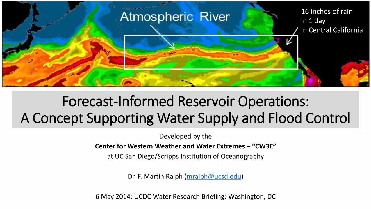
Forecast-Informed Reservoir Operations: A Concept Supporting Water Supply and Flood Control
Developed by the
Center for Western Weather and Water Extremes – “CW3E”
at UC San Diego/Scripps Institution of Oceanography
Dr. F. Martin Ralph ([email protected])
6 May 2014; UCDC Water Research Briefing; Washington, DC
16 inches of rain in 1 day in Central California
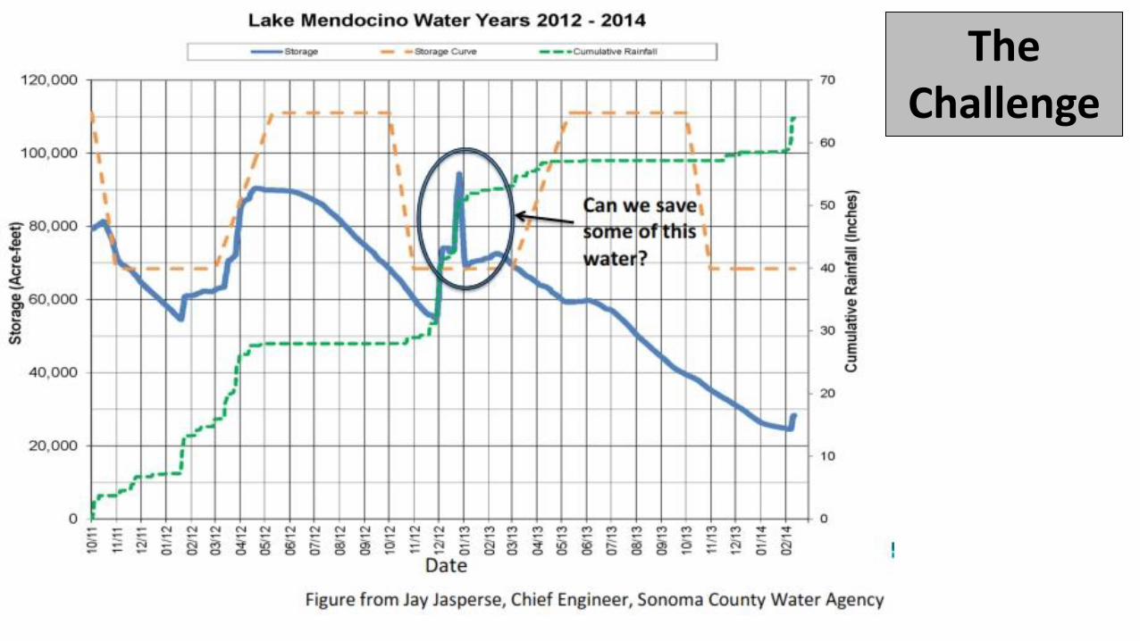
The Challenge
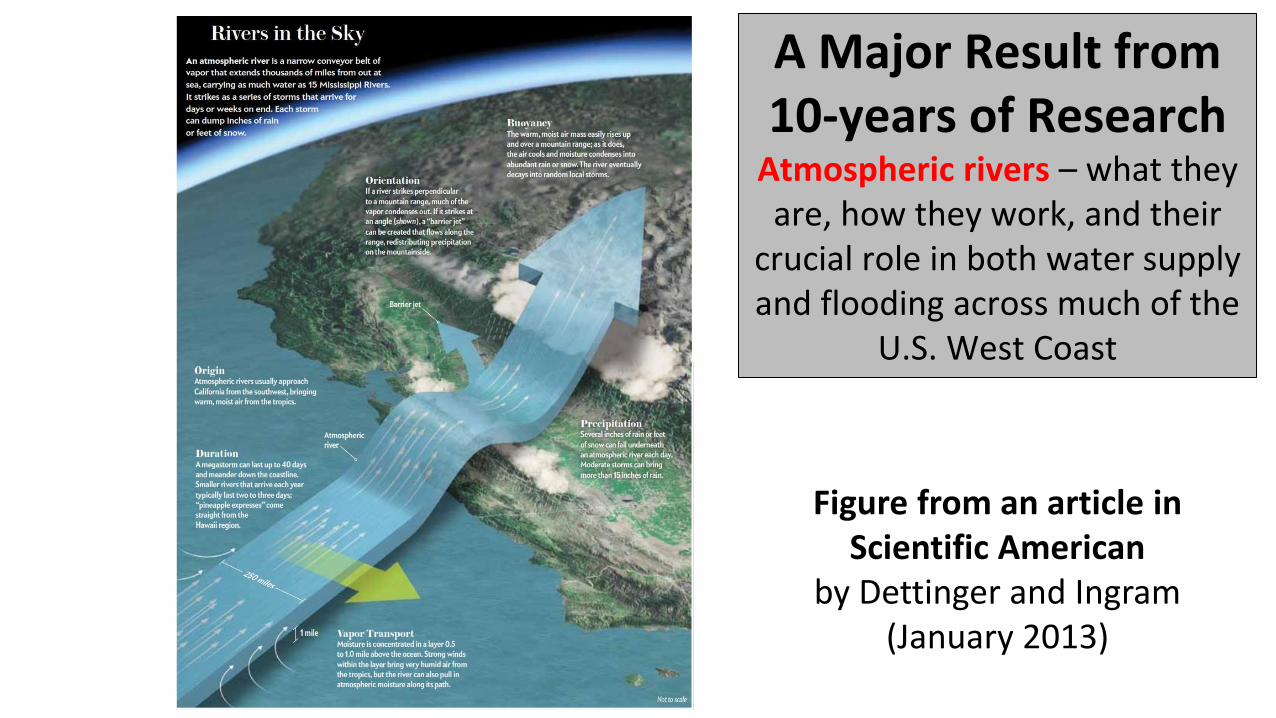
Figure from an article in Scientific American
by Dettinger and Ingram (January 2013)
A Major Result from 10-years of Research
Atmospheric rivers – what they are, how they work, and their
crucial role in both water supply and flooding across much of the
U.S. West Coast
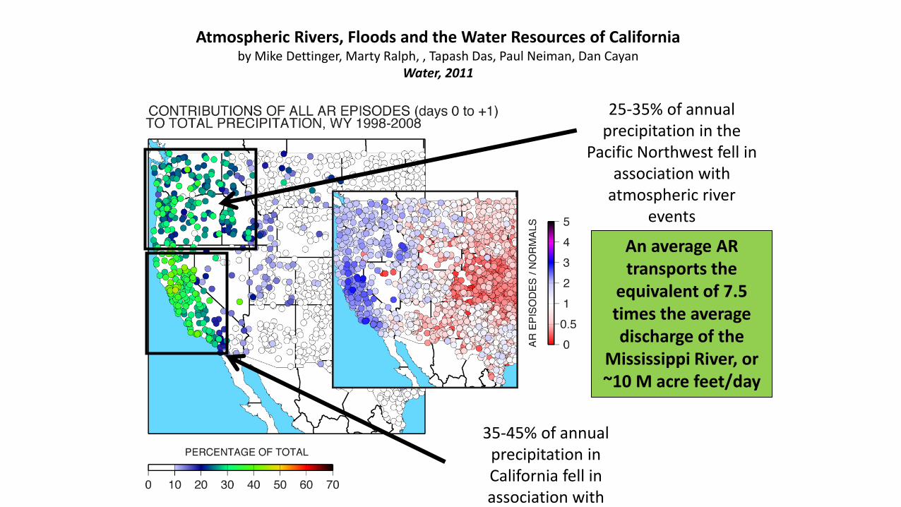
Atmospheric Rivers, Floods and the Water Resources of California by Mike Dettinger, Marty Ralph, , Tapash Das, Paul Neiman, Dan Cayan
Water, 2011
25-35% of annual precipitation in the
Pacific Northwest fell in association with
atmospheric river events
35-45% of annual precipitation in California fell in association with
atmospheric river events
An average AR transports the
equivalent of 7.5 times the average discharge of the
Mississippi River, or ~10 M acre feet/day
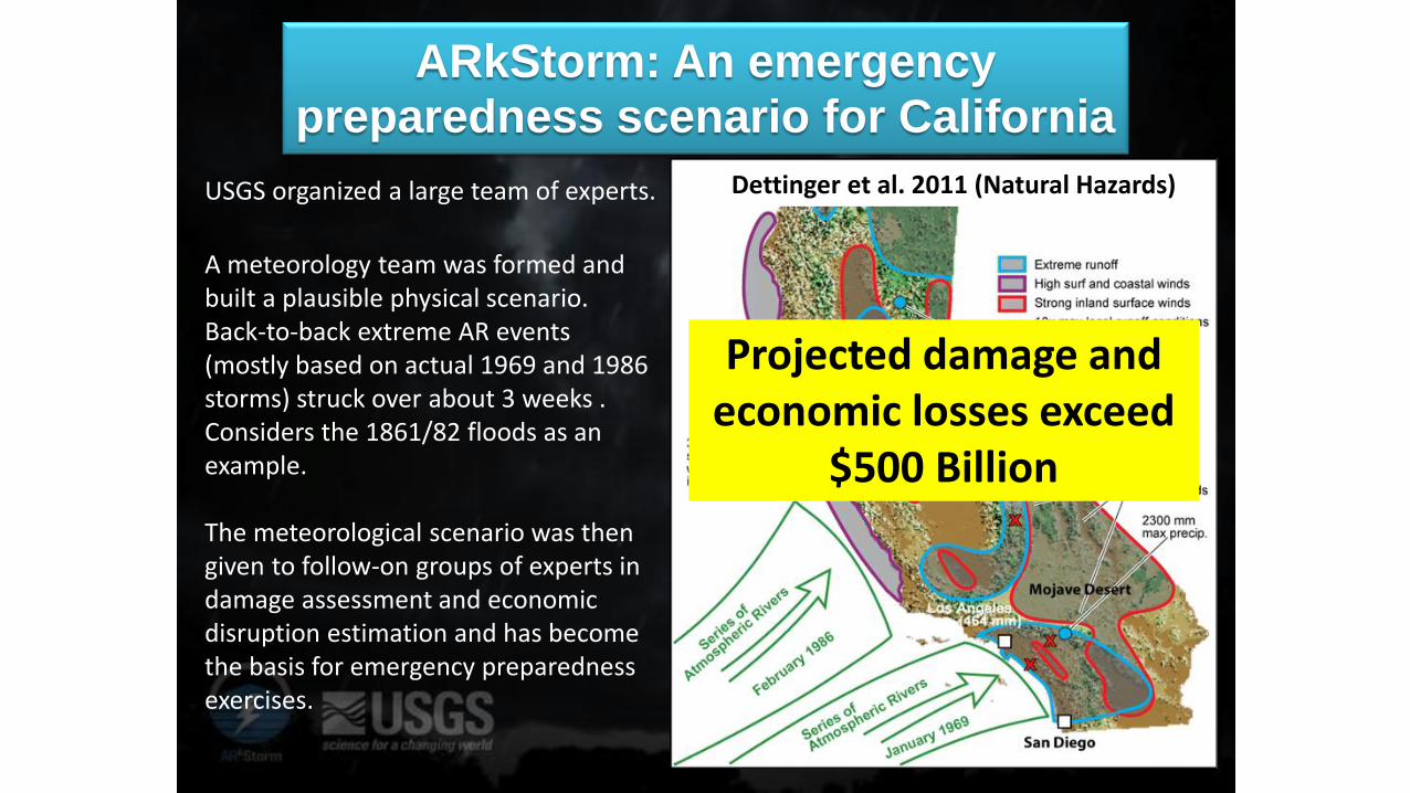
ARkStorm: An emergency preparedness scenario for California
USGS organized a large team of experts.
A meteorology team was formed and built a plausible physical scenario. Back-to-back extreme AR events (mostly based on actual 1969 and 1986 storms) struck over about 3 weeks . Considers the 1861/82 floods as an example. The meteorological scenario was then given to follow-on groups of experts in damage assessment and economic disruption estimation and has become the basis for emergency preparedness exercises.
Dettinger et al. 2011 (Natural Hazards)
Projected damage and economic losses exceed
$500 Billion
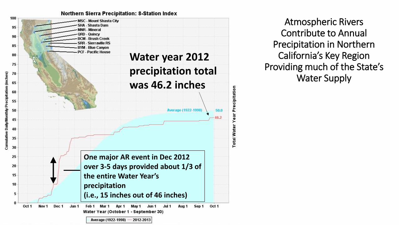
Atmospheric Rivers Contribute to Annual
Precipitation in Northern California’s Key Region
Providing much of the State’s Water Supply
One major AR event in Dec 2012 over 3-5 days provided about 1/3 of the entire Water Year’s precipitation (i.e., 15 inches out of 46 inches)
Water year 2012 precipitation total was 46.2 inches
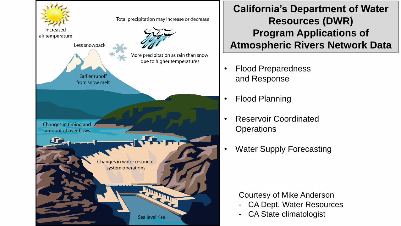
• Flood Preparedness
and Response
• Flood Planning
• Reservoir Coordinated
Operations
• Water Supply Forecasting
California’s Department of Water
Resources (DWR)
Program Applications of
Atmospheric Rivers Network Data
Courtesy of Mike Anderson
- CA Dept. Water Resources
- CA State climatologist
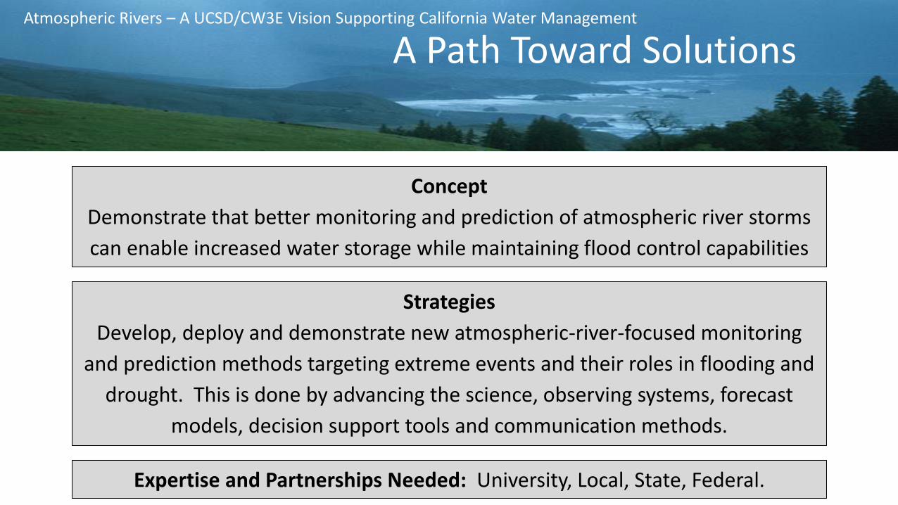
Concept
Demonstrate that better monitoring and prediction of atmospheric river storms
can enable increased water storage while maintaining flood control capabilities
Strategies
Develop, deploy and demonstrate new atmospheric-river-focused monitoring
and prediction methods targeting extreme events and their roles in flooding and
drought. This is done by advancing the science, observing systems, forecast
models, decision support tools and communication methods.
Atmospheric Rivers – A UCSD/CW3E Vision Supporting California Water Management
Expertise and Partnerships Needed: University, Local, State, Federal.
A Path Toward Solutions
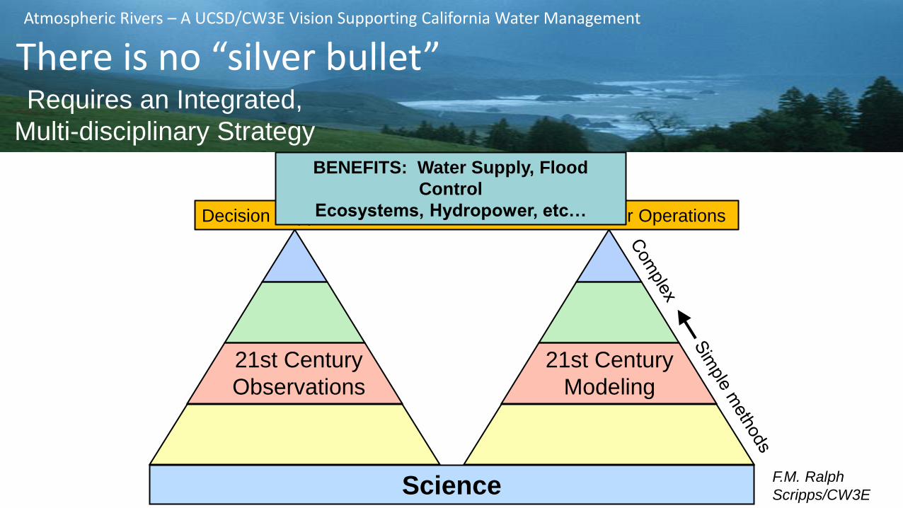
21st Century
Observations
21st Century
Modeling
Science
Decision Support Tools + Forecast-Informed Reservoir Operations
There is no “Silver bullet” for this complex problem.
F.M. Ralph
Scripps/CW3E
BENEFITS: Water Supply, Flood
Control
Ecosystems, Hydropower, etc…
Atmospheric Rivers – A UCSD/CW3E Vision Supporting California Water Management
There is no “silver bullet” Requires an Integrated,
Multi-disciplinary Strategy
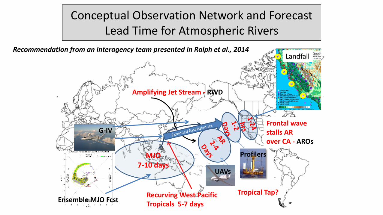
Conceptual Observation Network and Forecast Lead Time for Atmospheric Rivers
Recurving West Pacific Tropicals 5-7 days
Amplifying Jet Stream - RWD
G-IV
Profilers MJO 7-10 days
Ensemble MJO Fcst
Frontal wave stalls AR over CA - AROs
Tropical Tap?
UAVs
Landfall Recommendation from an interagency team presented in Ralph et al., 2014
11
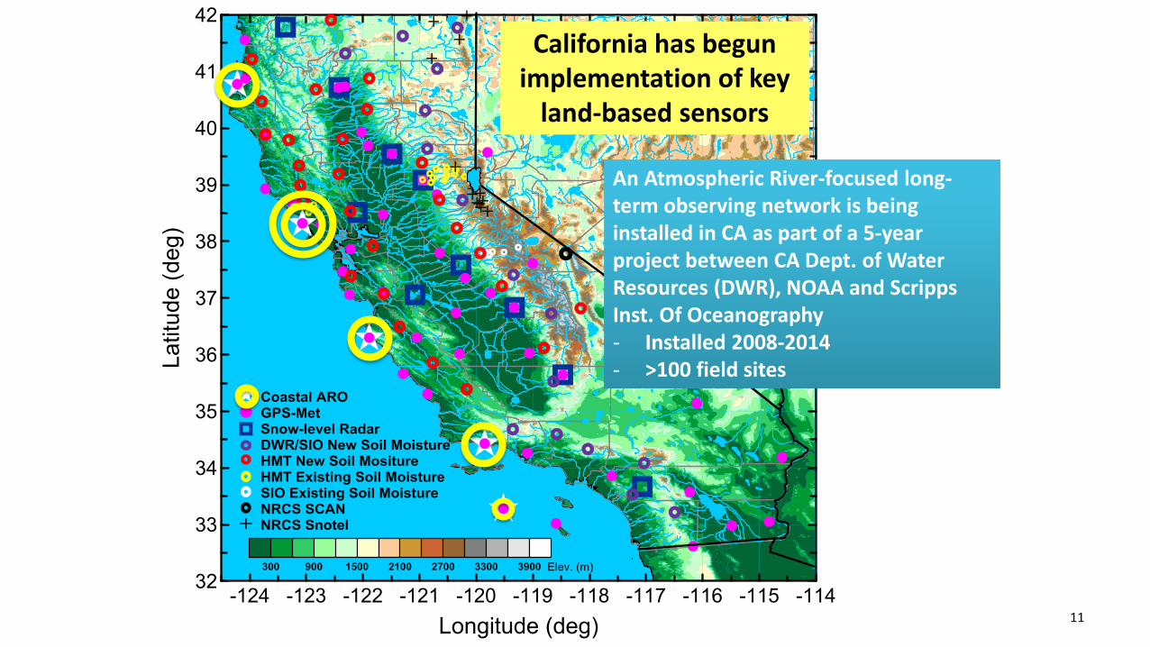
California has begun implementation of key
land-based sensors
An Atmospheric River-focused long-term observing network is being installed in CA as part of a 5-year project between CA Dept. of Water Resources (DWR), NOAA and Scripps Inst. Of Oceanography - Installed 2008-2014 - >100 field sites
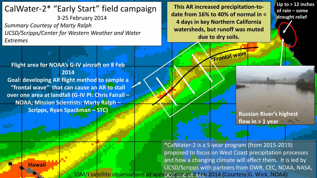
CalWater-2* “Early Start” field campaign 3-25 February 2014
Summary Courtesy of Marty Ralph UCSD/Scripps/Center for Western Weather and Water Extremes
Up to > 12 inches of rain – some drought relief
This AR increased precipitation-to-date from 16% to 40% of normal in <
4 days in key Northern California watersheds, but runoff was muted
due to dry soils.
*CalWater-2 is a 5-year program (from 2015-2019) proposed to focus on West Coast precipitation processes and how a changing climate will affect them. It is led by UCSD/Scripps with partners from DWR, CEC, NOAA, NASA, DOE and others. SSM/I satellite observations of water vapor on 8 Feb 2014 (Courtesy G. Wick, NOAA)
Russian River’s highest flow in > 1 year
Flight area for NOAA’s G-IV aircraft on 8 Feb 2014
Goal: developing AR flight method to sample a “frontal wave” that can cause an AR to stall
over one area at landfall (G-IV PI: Chris Fairall – NOAA; Mission Scientists: Marty Ralph –
Scripps, Ryan Spackman – STC)
Hawaii
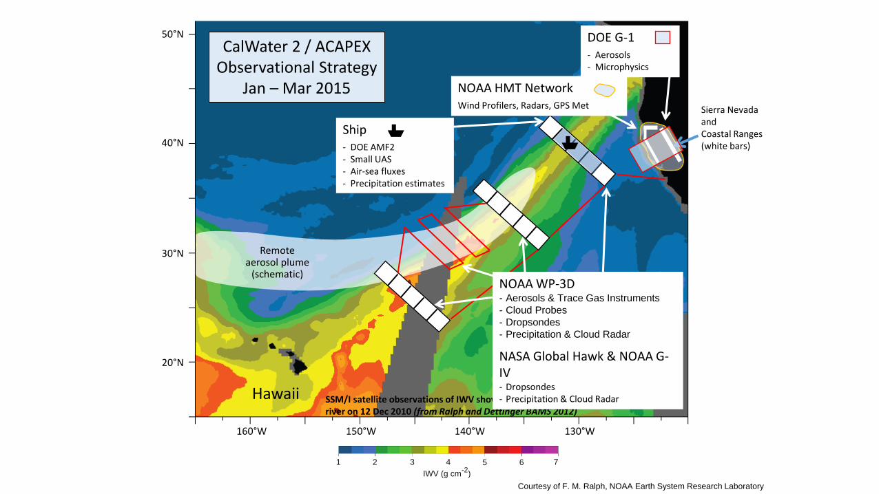
NOAA HMT Network
Wind Profilers, Radars, GPS Met Sierra Nevada and Coastal Ranges (white bars)
Hawaii SSM/I satellite observations of IWV showing a strong atmospheric river on 12 Dec 2010 (from Ralph and Dettinger BAMS 2012)
CalWater 2 / ACAPEX Observational Strategy
Jan – Mar 2015
Remote aerosol plume
(schematic)
20°N
30°N
40°N
50°N
160°W 150°W 140°W 130°W
50N
40N
30N
20N
160W 150W 140W 130W
7654321
IWV (g cm-2
)
40N
30N
20N
160W 150W 140W 130W 120W
12 December 2010
18 December 2010
NOAA WP-3D - Aerosols & Trace Gas Instruments
- Cloud Probes
- Dropsondes
- Precipitation & Cloud Radar
NASA Global Hawk & NOAA G-IV - Dropsondes - Precipitation & Cloud Radar
Courtesy of F. M. Ralph, NOAA Earth System Research Laboratory
DOE G-1
- Aerosols - Microphysics
Ship
- DOE AMF2 - Small UAS - Air-sea fluxes - Precipitation estimates
Scripps Institution of Oceanography
NASA JPL
Science and Technology Corporation
NOAA Earth System Research Laboratory
Water vapor budget of ARs offshore and their impacts on
landfall
- NASA Global Hawk (3 winters)
- NASA DC-8 (2 winters)
EFREP AR Obs network onshore
Marty Ralph (PI)
Duane Waliser (Deputy PI), Ryan Spackman (Deputy PI)
Atmospheric River Experiment – AREX Proposal to NASA’s EV AO
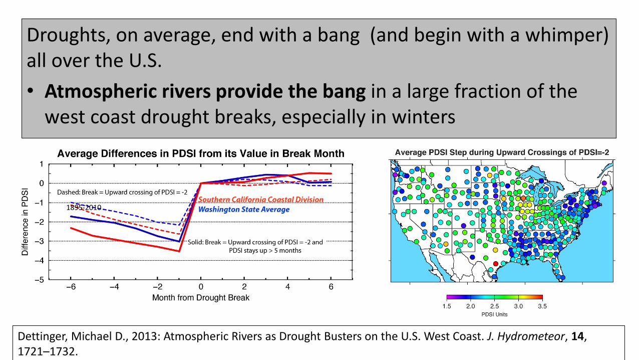
1895-2010
Dettinger, Michael D., 2013: Atmospheric Rivers as Drought Busters on the U.S. West Coast. J. Hydrometeor, 14, 1721–1732.
Droughts, on average, end with a bang (and begin with a whimper) all over the U.S.
• Atmospheric rivers provide the bang in a large fraction of the west coast drought breaks, especially in winters

Mission Provide 21st Century water cycle science, technology and outreach to support effective policies and
practices that address the impacts of extreme weather and water events on the environment, people and
the economy of Western North America
Goal Revolutionize the physical understanding, observations, weather predictions and climate projections of
extreme events in Western North America, including atmospheric rivers and the North American summer
monsoon as well as their impacts on floods, droughts, hydropower, ecosystems and the economy
Atmospheric
Rivers
(fall and winter)
Southwest
Monsoon
(summer & fall)
Great Plains Deep
Convection
(spring and summer)
Spring Front Range
Upslope
(rain/snow)
Center for Western Weather and Water Extremes Where: UCSD/Scripps Inst. Oceanography La Jolla, California When: Start - 2013 Who: Dr. F. M. Ralph (Director) Dr. Dan Cayan Dr. Mike Dettinger Dr. Ryan Spackman
Scripps Institution of Oceanography
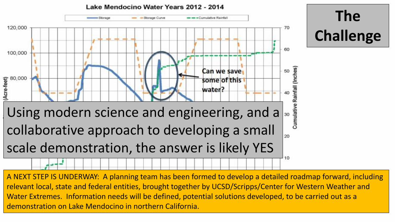
The Challenge
Using modern science and engineering, and a collaborative approach to developing a small scale demonstration, the answer is likely YES
A NEXT STEP IS UNDERWAY: A planning team has been formed to develop a detailed roadmap forward, including relevant local, state and federal entities, brought together by UCSD/Scripps/Center for Western Weather and Water Extremes. Information needs will be defined, potential solutions developed, to be carried out as a demonstration on Lake Mendocino in northern California.

Region for which atmospheric river events are a dominant cause of extreme precipitation, flooding and contribute to water supply in the Western U.S. (Ralph et al. 2014)
18
Region of major atmospheric river influence
Lake Mendocino - Pilot study
Contact: F. Martin Ralph ([email protected]) Website: http://woodland.ucsd.edu/