Embed Size (px)
Citation preview

Ford Road Industrial Landfill
Elyria, OhioLorain County
EPA Region 5 Records Ctr.
267897
Record of Decision
United StatesEnvironmental Protection Agency
Region 5
September 2006

TABLE OF CONTENTS
List of Acronyms and Abbreviations vi
PARTI DECLARATION viiiPART II DECISION SUMMARY 7
1.0 Site Name, Location and Brief Description 7
2.0 Site History and Enforcement Activities 82.1 Source of Contamination 82.2 Previous Investigations 8
2.2.1 Field Investigations 82.2.2 ODH Health Assessments 10
2.3 Previous Response Actions 112.4 Enforcement Activities 11
3.0 Community Participation 11
4.0 Scope and Role of Response Action 124.1 Operable Unit 1 12
5.0 Operable Unit Characteristics 135.1 Conceptual Site Model 135.2 Operable Unit Overview 135.3 Sampling Strategy 155.4 Source of Contamination 155.5 Types of Contaminants and Affected Media 165.6 Extent of Contamination 16
5.6.1 Soil Investigation and Results 165.6.2 Groundwater Results 185.6.3 Leachate Results 195.6.4 LNAPL Investigation and Results 205.6.5 Sediment Investigation Results 215.6.3 Surface Water Investigation Results 23
6.0 Current and Potential Future Land and Resource Uses 24
7.0 Summary of Operable Unit Risks 247.1 Summary of Human Health Evaluation 25
7.1.1 Identification of Contaminants of Concern 257.1.2 Exposure Assessment 257.1.3 Toxicity Assessment 277.1.4 Risk Characterization 28
ii

7.2 Summary of Ecological Risk Assessment 307.2.1 Site Characterization 317.2.2 Ecological Toxicity Assessment 327.2.3 Ecological Risk Characterization 327.2.4 Ecological Risk Conclusions 33
8.0 Remedial Action Objectives and ARARs 348.1 Remedial Action Objectives 348.2 Applicable or Relevant and Appropriate Requirements (ARARs) 35
9.0 Description of Alternatives 359.1 Description of Remedy Components .' 379.2 Common Elements and Distinguishing Features of Each Alternative 43
9.2.1 Institutional Controls 439.2.2 Additional Work Performed During Design Phase 439.2.3 Operation, Monitoring and & Maintenance 449.2.4 Surface Water Management 44
9.3 Expected Outcomes of Each Alternative 449.4 Preferred Alternative 45
10.0 Summary of Comparative Analysis of Alternatives 4510.1 Overall Protection of Human Health and the Environment 4610.2 Compliance with ARARs 4710.3 Long-Term Effectiveness and Permanence 4710.4 Reduction of Toxicity, Mobility, or Volume Through Treatment 4810.5 Short-Term Effectiveness 4810.6 Implementability 4810.7 Cost * 4910.8 State Agency Acceptance 4910.9 Community Acceptance 50
11.0 Principal Threat Wastes 50
12.0 Selected Remedy 5012.1 Identification of the Selected Remedy and Summary of the Rationale
for its Selection 5012.2 Description of the Selected Remedy .'. 5012.3 Summary of the Estimated Remedy Costs and Time Required for
Implementation...... 5212.4 Expected Outcomes of the Selected Remedy 52
13.0 Statutory Determinations 53
• • •
111

TABLE OF CONTENTS (<
13.1 Prelection of Human Health and the Environment — 54132. Compliance with ARARs 54133 Cost Effectiveness 5413.4 Rve-Year Review Requirements 54
14.0 Documentation of Significant Changes 55
IV

TABLES
Table 1 Soil Comparison of Metals Data to Background Metals Data 17Table 2 Groundwater Comparison of Metals Data to Background Metals Data. 19Table 3 COPCs for Ford Landfill SiteTable 4 Development of Site-specific Risk-Based Concentrations For Carcinogenic
Constituents in SoilTable 5 Development of Site-Specific Risk-Based Concentrations for Non-Carcinogenic
Constituents in SoilTable 6 Development of Site-Specific Risk-Based Concentrations for Carcinogenic
Constituents in SedimentTable 7 Development of Site-Specific Risk-Based Concentrations for Sediment (Adult
Receptor)Table 8A Chemical Specific ARARs and TBCsTable 8B Location Specific ARARs and TBCsTable 8C Action Specific ARARs and TBCsTable 9 Summary of Estimated Costs for Each Alternative 49Table 10 Site Groundwater and Surface water StandardsTable 11 Site Leachate StandardsTable 12 Cost Breakdown for Alternative 3Table 13 Cost Breakdown for Alternative A
FIGURES
Figure 1Figure 2Figure3Figure 4FigureSFigure 6
Site Location MapSite Layout MapConceptual Site ModelWater Contour MapAlternative 3 Conceptual IllustrationAlternative A Conceptual Illustration
Unless otherwise noted, Tables and Figures are found following the Decision Summary
APPENDICES
Appendix A Responsiveness SummaryAppendix B Administrative Record Index

LIST OF ACRONYMS AND ABBREVIATIONS
AOC administrative order on consentARAR applicable or relevant and appropriate requirementATSDR Agency for Toxic Substances and Disease Registryarm! avenge mean sea levelbgs below ground surfaceCERCLA Comprehensive Environmental Response, Compensation, and Liability ActCFR Code of Federal RegulationsCIP Community Involvement PlanCOPC chemical of potential concernCSM conceptual site modelEco-SSL Ecological Soil Screening LevelsEOLP Erie/Ontario Lake PlainEPA Environmental Protection AgencyESL Ecological Screening LevelFS feasibility studyHAS Health Administration ServiceHHE human health evaluationIMZM Inside Mixing Zone MaximumIRIS Integrated Risk Information SystemLNAPL Light Non-Aqueous Phase LiquidMCL maximum contaminant levelMetroParks Lorrain Metropolitan Park DistrictMW Monitoring Wellmg/kg miUigrams per kilogramNCP National Contingency PlanNPL National Priorities ListODH Ohio Department of HealthOMZA Outside Mixing Zone AverageOU Operable UnitO&M Operation and MaintenancePAH poly aromatic hydrocarbonppm part per millionPCB polychlorinated biphenyiPEC probable effects concentrationPRP Potentially Responsible PartyPRG Preliminary Remediation GoalRAGS Risk Assessment Guidance for SuperfundRAO remedial action objectiveRBC risk based concentrationRI remedial investigationRI/FS remedial investigation/feasibility studyRME reasonable maximum exposure
vi

ROD Record of DecisionSARA Superfund Amendments and Reauthorization ActSF slope factorSVOCs semi-volatile organic compoundsTBC to be consideredTEC threshold effects concentrationug/kg microgram per kilogramU.S. EPA United States Environmental Protection AgencyVOCs volatile organic compounds
Vll

Record of Decision - Fort Road Industrial Landfill
Elyria, Ohio
This Record of Decision (ROD) documents the remedy selected for the Ford Road IndustrialLandfill Site in Lorain County, Ohio. The ROD is organized in two sections: Part I contains theDeclaration for the ROD and Part n contains the Decision Summary. The ResponsivenessSummary is included as Appendix A.
PARTI: DECLARATION
This section ^ymanmres. the information presented in the ROD and includes the authorizingsignature of the United States Environmental Protection Agency (U.S. EPA) Region 5 SuperfundDivision Director.
Site Name and Location
The Ford Road Industrial Landfill Site (CERCUS # OHD9805 10002) is located in Elyria, LorainCounty Ohio, about 1.5 miles from Interchange 8 of the Ohio Turnpike Interstate 90. The FordRoad Industrial Landfill Site is a 15-acrc inactive facility situated in die northern end of Elyria onFord Road.
Statement of Basis and Purpose
This decision document presents the selected remedy for the Ford Road Industrial Landfill Site(Ford Road Landfill). The remedy was chosen in accordance with the ComprehensiveEnvironmental Response, Compensation and Liability Act (CERCLA), as amended by dieSuperfund Amendments and Reauthorization Act (SARA), and, to the extent practicable, theNational Contingency Plan (NCP). Information used to select the remedy is contained in theAdministrative Record file for the Site. The Administrative Record file is available for review atthe U.S. EPA Region 5 Records Center, 77 West Jackson Boulevard, Chicago, Illinois, and at theElyria Public Library - West River Branch, 1 194 West River Road, Elyria, Ohio.
Assessment of the Site
The response action selected in this ROD is necessary to protect the public health or welfare orthe environment from actual or threatened releases of hazardous substances into the environment.
Vlll

Description of Selected Remedy
The Ford Road Industrial Landfill Site is being addressed as one Operable Unit (OU) under theframework set forth in CERCLA. The selected remedy specified in this ROD will serve as thefinal action for the Site. The selected remedy specifies response actions through surface coverenhancement, hot spot removal, and imposition of institutional controls and future monitoringthat will address contaminated soils/sediments, a source area, and groundwater at the Site. U.S.EPA believes the response actions outlined in this ROD, if properly implemented, will protecthuman health and the environment.
The selected remedy consists of a focused removal of wastes on the side slopes and re-grading toimprove surface water control over the extent of the landfill and the placement of additional low-permeability material over those areas of the landfill that do not currently meet the minimum 2-foot landfill cap system cover requirement of Ohio EPA [Ohio EPA - DSIWM Guidance #0123OAC 3745-27-09(F)]. The focused waste removal activities would concentrate on the areaswithin the landfill footprint on the north and south slopes where waste material (including largewaste objects such as white goods, drum carcasses, etc) are exposed at the surface. The areasrequiring enhancement of the existing cover are primarily on the northern and southern slopes ofthe landfill. The possibility of slope modifications will be addressed during the design phase ofthe remedy implementation. Landfill waste that has, over time, cascaded over the sides of thelandfill and remains exposed will be consolidated within the existing or extended limits of thelandfill or be disposed of at a licensed facility, if necessary.
Upon completion of cover enhancements and removal of exposed wastes and, if necessary, sideslope modifications, a continuous 2-foot cover or an equally protective cover approved by theU.S. EPA will be placed over the entire landfill. This enhanced cover over the entire landfill willreliably contain the landfill wastes and will also serve to mitigate any of the waste material fromcontaminating water that infiltrates through the landfill itself, passing through soil and sediment,and then flowing into the Black River.
In addition, the remedy will include the removal of a select soil and sediment hotspot located justoutside of the landfill limits in the northeastern comer of the Site. While installing a monitoringwell during the investigation, a Light Non-Aqueous Phase Liquid (LNAPL) was found to containhigh levels of polychlorinated biphenyl (PCB) contaminated motor oil. This LNAPL was foundto be migrating into the Black River from a small source area. The selected remedy will includeremoving the impacted sediment at the edge of the river, extending back toward the toe of thelandfill slope. This will remove all impacted soil in the preferential migration pathway alongwhich the LNAPL has likely migrated toward the edge of the river from surface water infiltratingthrough the landfill.
The LNAPL found at the northeastern corner of the Site could be termed a principal threat if itwere to remain in place. Parts of the remedy (surface cover enhancement and hot spot removal)will, however, alleviate the principal threat by ensuring adequate cover to prevent the infiltration

of water through the landfill which could aid in the migration of the LNPAL. More importantlyby removing the source area, the selected remedy will remove the principal threat.
The major components of the selected remedy include:
• The focused removal of waste on the side slopes, the enhancement of the existing landfillcover and the placement of additional low-permeability material over those areas of thelandfill that do not currently meet the 2-foot minimum landfill cap system coverrequirement (primarily the areas on the northern and southern side slopes of the landfill).To the extent practicable, existing cover materials will be reused. This may involvemoving materials from the top of the landfill where the cover is in excess of two feetduck to the side slopes.
• Vegetation will need to be removed to accomplish the cover enhancements along thelandfill slopes. This will involve removing any vegetation within the landfill footprintitself and ensuring that trees and shrubs remaining close to the landfill footprint will notcompromise the new landfill cover. Actions to maintain stable slopes will also bepafoimed (e.g., appropriate replacement vegetation and/or slope stabilizing controls).The landfill will then be revegetated with native vegetation in a manner that healthygrasses or other vegetation will form a complete and dense vegetative cover within oneyear of placement
• Cascaded waste found over an approximately 5,000 square foot area on the northern slopeof die landfill and an approximately 15,000 square foot area on the southern slope of thelandfill (both areas are located outside the actual boundary of the landfill) will beaddressed by consolidating the waste within the existing or extended limits of the landfill.If determined to be necessary, the waste will be disposed of at a licensed facility. It isassumed that a limited amount of the material will require offsite disposal and most of thematerial will be consolidated within the limits of the landfill. Material consolidatedwidiin the limits of waste will be placed in lifts and compacted in areas on the top of thelandfill after the existing cover has been stripped for reuse. Surficial wastes will beremoved to native material, unless the underlying material exceeds regulatory limits.Backfill will only be expected to be placed in these areas, as required, to result inappropriate stable slopes beyond the limits of the landfill, depending on the final grade.
• Modifications to die existing cap may affect the stability of the side slopes of the landfill.It is assumed that the North End Slope, Southern End Slope, the northern portion of theEastern Side Slope, and approximately half of the southern portion of the Eastern SideSlope (approximately 73,000 square feet, total) may require stabilization. However, theexact extent will be based on evaluations made as part of the Remedial Design phase.
• A detailed analysis of the slope stability will be conducted during the Remedial Designphase and will include slope stability analysis outlined in: Geotechnical and StabilityAnalyses for Ohio Waste Containment Facilities (GeoRG) Manual 660 at

http://www.epa.state.oh.us/dsiwm/pages/alpha e-h.html.. Should this analysis show thatfurther modifications are required to maintain slope stability during and after capmodifications, possible response actions could include laying back the side slopes fromthe existing toe, extending the existing toe with appropriate adjustment of the side slopes,or adding a structural enhancement at the existing toe then adjusting the side slopes fromthe top of the structure. Laying back the slopes from the existing toe to a 3:1 slope wouldrequire the removal of approximately 250,000 cubic yards of existing cap and fillmaterial, while a 4:1 slope would require the removal of approximately 515,000 cubicyards of existing cap and fill material. Installing a structural enhancement at the existingtoe would be expected to significantly decrease this volume. Further evaluation of theseoptions, if necessary, will be part of the Remedial Design phase. It is assumed thatexcavated materials would be placed under the enhanced cap. However, it is possible thatpart of this material may need to be disposed of at an appropriately licensed offsitefacility.
• Upon completion of this portion of the remedy, the Ford Road Landfill will have acontinuous 2-foot cover of approved material encompassing the entire landfill limits withall of the currently exposed wastes either contained within the existing landfill or shippedoff-site for disposal.
• Removing selected soil/sediment observed to contain elevated levels of PCBs and motoroil outside of the landfill limits in the northeast corner of the Site. The removal depth isassumed to be approximately fifteen feet. Additional sampling data will be collectedduring the Remedial Design stage to determine the actual extent of contamination beforethis alternative is implemented.
• The excavation will remove the impacted sediment at the edge of the river and thenextend back towards the toe of the landfill slope. It is estimated that up to 6,400 cubicyards of soil and sediment will need to be removed, although the actual removal limitsand depth will be determined during the Remedial Design stage. To the degreepracticable, non-impacted surface soil will be removed, stockpiled, and characterized,which could significantly reduce the volume of soil requiring disposal. Excavatedmaterials that are demonstrated to not contain chemicals of potential concern (COPCs)will be used either in construction of landfill cover improvements or placed under the capwithin the landfill with U.S. EPA's and Ohio EPA's approval. Soils and sedimentscontaining COPCs with levels exceeding regulatory limits, including PCBs and motor oil,will be sent offsite for disposal. The excavated areas will be backfilled, as required toestablish surface contours, with clean, compacted, low permeability fill and revegetated.A reducing media that can fully degrade any residual levels of COPCs may be used oradded to the backfill if necessary.
• Regular monitoring including inspections, groundwater sampling and other monitoringactivities will occur at the Site. Institutional controls will also be implemented at the Sitegenerally consisting of nonintrusive legal and/or administrative controls that reduce
potential exposure to impacted materials and/or to mitigate the potential for jeopardizingthe integrity of the remedy. Typical institutional controls involve the placement of deedrestrictions on the property to prevent intrusive actions and future development ofbuildings for routine human occupancy on the landfill cover or drinking-water wells, ft isanticipated that all institutional controls will be implemented by the Responsible Partiesor Respondents.
Statutory Determinations
The selected remedy is protective of human health and the environment, complies with federaland stale requirements that are applicable or relevant and appropriate to this remedial action, iscost-effective, and utilizes permanent solutions and alternative treatment technologies (orresource recovery) to the maximum extent practicable and satisfies the statutory preference forremedies that employ treatment that reduces toxicity, mobility, or volume as a principal elementBecause this remedy will result in hazardous substances, pollutants or contaminants remainingon-site at levels greater than those that allow for unlimited use and unrestricted exposure, astatutory review will be conducted within five years after initiation of remedial action to ensurethat the remedy is, or will be protective of human health and the environment
Data Certification Checklist
The following information is included in the Decision Summary section (Part H) of this ROD.Additional information can be found in the Administrative Record file for this Site.
• Contaminants of concern and their respective concentrations (Section 5);• Baseline risk represented by the contaminants of concern (Section 7);• Cleanup levels established for contaminants of concern and the basis for these levels
(Section 8);• How source materials are not considered a principal threat (Section 11);• Current and reasonably anticipated future land use assumptions used in die baseline risk
assessment and ROD (Sections 6 and 7);• Potential land use that will be available at the Site as a result of the selected remedy
(Section 12);• F«ritMti>«i total prwnt worth rmgftt and ttv numhtM- r>f y»»arg nwr uitiioh riv» n-nwty fret
estimates are projected (Sections 9 and 12); and• Key factors that led to selecting the remedy (Sections 10 and 12).
Support Agency Acceptance
Although the State of Ohio has not yet provided a concurrence letter for mis ROD, the State hasindicated that it intends to concur with the selection of Alternative 3 and Alternative A for theFord Road Industrial Landfill Site. The State of Ohio's concurrence letter will be added to theAdministrative Record upon receipt

Authorizing Signature
Richard C. Karl, DirectorSuperfund DivisionUnited States Environmental Protection Agency, Region 5
Date

Eryria,Ohio
PARTD: DECISION SUMMARY
14 Site Name, Location and Brief Description
The Font Road Landfill is a 15-acrc inactive facility located in Syria, Lorain County, Ohio. TheSite is located on the northern edge of Elyria on Ford Road, about 1.5 miles from Interchange 8of the Ohio Turnpike, Interstate 90 (Figure 1). The Site is not fenced and is accessible from allsides. Several residences are located within one mile of the site with the nearest being about 200feet northwest of the site. The Site is bordered by an intermittent stream and a sewer main that iscovered with riprap to the north, a ravine and-rural land to the south, the Black River to the east,and Ford Road and die Black River Preserve to the west. Site topography is characterized by thegently sloping top surface of the landfill which descends from an elevation of approximately 690feet above mean sea level (amsl) at the western boundary of the Site along Ford Road to anelevation of approximately 680 feet amsl at the top of the slope around the northern, eastern, andsouthern edge of the landfill surface. The northern, eastern, and southern flanks of the landfillslope steeply down to die 100-year flood plain of the Black River at an elevation ofapproximately 610.9 feet amsl. A swale, oriented approximately north-south, was constructedalong die western edge of the landfill. The swale directs runoff into a stormwater drain thatdischarges into the intermittent stream which is a crushed stone-filled drainage feature matextends from Ford Road to the Black River immediately north of die Site.
Figure 2 illustrates the layout of die landfill. The top of the landfill appears to have an adequatecover of low-permeability soil. Landfill wastes are covered on the top of die landfill. However,uncovered wastes, miscellaneous debris, and white goods that are located along the southern andnorthern landfill side slopes. The landfill top is well graded and gently slopes west to east withan eastern side slope grade approaching 2.5:1 Height: Vertical ratio, while the north and southside slopes of the landfill are steep with grades of approximately 1.2:1 Height: Vertical ratio.The cap and slope coverings of die landfill are generally intact and support healthy vegetation(grass and tree/shrub growth). There is, however, some evidence of waste and soil erosionoccurring on die steep northern and southern side slopes. No landfill gas has been observedmigrating duough the existing cap at the Ford Road Site and a gas monitoring system is in placeat die Site.
The Ford Road Landfill is being addressed as a Superfund Alternative Site. The PotentiallyResponsible Parties (PRPs) are therefore allowed to lead in the investigation of die Ford RoadSite, with U.S. EPA oversight. Because this is a voluntary action by the PRPs the Site is notlisted on die National Priorities List (NPL). The PRP Group for the Ford Road Site signed anAdministrative Order of Consent (AOC) in 2001 to complete a RemedialInvestigation/Feasibility Study (RI/FS) at Ford Road Landfill. The Ford Road PRP Group began

the RI/FS at the Ford Road Site in 2003 and both U.S. EPA and Ohio EPA provided oversight ofthe Ford Road PRP Group's work under the AOC. The Ford Road Group completed theRemedial Investigation/Feasibility Study Report, Ford Road Landfill, Elyria, Ohio in 2006. U.S.EPA anticipates that the design and implementation of the remedy selected in this ROD will becarried out by the Ford Road PRP Group under a federal consent decree.
2.0 Site History and Enforcement Activities
2.1 Source of Contamination
Landfilling activities are believed to have begun with the placing of local municipal waste intothe ravine extending east from Ford Road in the early 1900s. Available records indicate thatBrotherton Disposal Company, Brotherton Disposal, Inc., and Browning-Ferris Industries ofOhio, Inc. operated a landfill at the Ford Road Site for various periods in the 1960s and early1970s. In 1972, Brotherton Disposal, Inc., merged with Browning-Ferris Industries of Ohio.According to Lorain County Records, George C. Brotherton and Phyllis J. Brotherton, doingbusiness as Brotherton Disposal and later as Brotherton Disposal, Inc., leased the landfill fromJack Joseph from 1964 to 1973. In 1973, Brotherton Disposal Inc. leased the landfill from theLorain County Metropolitan Park District. During operation of the landfill in the 60s and 70s,municipal and various industrial wastes in drums and in bulk were accepted, including, but notlimited to: 700 tons of hazardous material; 3.3 million pounds of chemical wastes; and 32,000gallons of sludge per day from 1963 to 1970, and many of these wastes were burned onsite.Foundry sand, slag, and dried sludges were often used for cover material. Landfill operationsended in 1974, but the landfill was not closed under U.S. EPA guidelines. The current owner ofthe Site is the Lorain County Metropolitan Parks District (MetroParks).
2.2 Previous Investigations
2.2.1 Field Investigations
Past investigations at the Ford Road Landfill appear to have begun in the early 1970s. An OhioEPA sanitary landfill inspection form reported conditions observed at the landfill on December21,1972, including the presence of leachate near the northeastern corner of the Site. It wasfurther observed that insufficient cover material was present for the landfill. An inspection of thelandfill in June 1976 documented improved conditions, although it indicated continued concernsregarding adequacy of cover and an observation of the leachate in the northeastern corner of theSite. On September 30,1980, a site inspection was performed by the U.S. EPA. During theinspection, leachate was reportedly observed to be entering the Black River at the northeasterncorner of the Site. The analytical results (dated October 20,1980) for both one leachate sampleand one sediment sample collected from observed seepage points located between thenortheastern toe of the landfill and the Black River showed detectable concentrations ofammonia, lead, boron, cadmium, zinc, barium, chromium, titanium, tetrahydrofuran,dimethylbenzene, ethylbenzene, 3,3,5-trimethylcyclohexanone, trimethylcyclohexanol, 1,1oxybisbenzene, methylenebisbenzene, and bis(2-ethylhexyl)phthalate. The sediment sampled .
8

contained bis(2-ethylhexyl)phthalate, phenol, methylphenol, IH-Indole, tetradecanediols, andPCBs.
An Evaluation of the Potential for Grotauhvater Contamination at the Ford Road Site wasprepared by a U.S. EPA contractor, E&E, on behalf of the U.S. EPA, dated October 16,1981.This evaluation concluded that impacts to the deeper bedrock aquifer were unlikely due to therelatively impermeable shale cap rock. In addition, the evaluation determined that potentialimpacts to groundwater in the overburden could impact the Black River and should be evaluatedby installing and sampling four to five wells. On August 23 and 24,1982, three shallowoverburden monitoring wells (MW-1, MW-2, and MW-3) were drilled and installed by ATECEnvironmental Consultants. One borehole was also advanced upgradient of the site; however, nogroundwater was encountered above the shale bedrock and no monitoring well was installed atthis location.
A preliminary assessment of the Ford Road Landfill was prepared by E&E on behalf of the U.S.EPA, dated January 5, 1983. Based on an evaluation of available information from the fieldinvestigation team files, Ohio EPA files, and U.S. EPA Region 5 files, additional informationwas considered necessary to assess potential impacts to groundwater, surface water, and/or soil.On July 20,1983, during a site inspection, E&E collected groundwater samples from each of thethree existing monitoring wells at the Site on behalf of the U.S. EPA. Two of the samples werefound to contain low concentrations of acetone and alphabenzene hexachloride. A third samplecontained methytene chloride.
On January 10,1994, a U.S. EPA contractor, PRC Environmental Management, Inc. submittedthe Expanded Site Inspection Report. The activities completed by PRC included an inspection ofthe site on March 8,1993, during which a leachate seep was observed flowing toward the BlackRiver near the northeastern corner of the Site. On May 18, 1993, PRC sampled soil, surfacewater, sediment, and groundwater at the Site. PCB (Aroclor-1254), delta-BHC, alpha chlordane,calcium, lead, and zinc were delected in one or more sediment samples. No hazardoussubstances were identified at levels above background in surface water samples. Also, 1,1-dichloroethene, potassium, and sodium were detected in one or more of the groundwatersamples. Arsenic, barium, manganese, and nickel were also detected at elevated concentrationsin both sediment and groundwater.
Browning-Ferris Industries of Ohio conducted monthly methane gas monitoring from February 8,1989 through January 31,1994. This monitoring program involved monitoring for methane gasat 10 locations across the landfill during each monitoring event The monitoring results showed0% of the lower explosive limit and 0% by volume from all locations during each monitoringevent implemented. A landfill gas monitoring system was formally approved by Ohio EPA inearly 2006 and sampling results have shown that no landfill gas is migrating through the existingcap.
In 1980, with the approval of the U.S. EPA and the MetroParks, Browning-Ferris of Ohioimplemented a voluntary response action involving the addition and grading of cover soil

(including placing up to 7.5 feet of low-permeability cover materials) to intercept and containreported observations of leachate emanating from the Site. In addition, some refuse observednear the river was removed and transported to the Lorain County Landfill.
Ohio EPA has collected fish tissue data in the Black River as part of its state program. Currently,the Black River has a fish advisory for Common Carp for PCBs and a PCB and mercury advisoryfor Freshwater Drum. Aroclor 1242 and Aroclor 1254 are present at elevated concentrations inthe LNAPL. However, Aroclor 1242 was not detected and only low levels of Aroclor 1254 weredetected in fish tissue samples collected from areas near the landfill. However, through sedimentsampling and the observation of black stained soil along the bank of the river adjacent to the Siteconducted during the RI at Ford Road Landfill, it is apparent that a small amount of PCBcontamination is entering into the Black River and could pose a risk to the ecological communityresiding in the river.
2.2.2 ODH Health Assessment
In 2001, the Health Assessment Section (HAS) of the Ohio Department of Health (ODH) wasasked by the U.S. EPA to evaluate site conditions and available sampling results at the FordRoad Landfill to determine if any contaminants present at the Site could pose a health threat tohumans in the vicinity of the landfill. The Ford Road Landfill Health Consultation was preparedby the ODH under a cooperative agreement with the Agency for Toxic Substances and DiseaseRegistry (ATSDR). The Division of Health Assessment and Consultation, ATSDR, reviewedthis public health consultation and concurred with the findings.
Based upon ODH's review, it was determined that the main pathway of concern was contact oringestion of surface water or sediments near the northeastern corner of the Site by the BlackRiver and the Black River itself. It was stated that the Black River near the Site supports a viablefish population and may be regularly fished by area residents. It was also indicated that eatingcontaminated fish from the Black River could be a pathway of concern depending on the currentlevel of contamination in the river and the kinds of chemicals present. Prior to this consultation,environmental data for the site was extremely limited with the most recent sampling occurring in1993. ODH stated that to adequately assess the threat to human health, it would be necessary toconduct a more thorough investigation of the site to characterize the potential for sitecontaminants that would migrate to the Black River.
Other potential hazards at the site that were identified during this assessment included thephysical hazards present along the steep side slopes of the landfill. The Site was and stillremains unfenced providing easy access to the Site. Crushed drums and exposed waste foundalong the northern and southern edges of the landfill posed a physical threat anyone venturing onthe sides of the landfill. There were also several areas of exposed ash found during theassessment that were of unknown origin and could have possibly contained hazardousconstituents, posing a health threat to those who came into contact with this area.
After ODH assessed the Site, they made the following recommendations:
10

1. A thorough environmental investigation of the Site, including surface soil, groundwater,sediment, and landfill gas should be completed at the Site to better characterize the levelsof hazardous waste in the landfill and the extent of impact on the surroundingenvironment.
2. Access to the Site should be restricted so as to reduce the possibility that children orothers could injure themselves on the exposed drums and waste that are present at thelandfill.
3. Since contamination is present in the sediments or surface water of the river, Ohio EPAmay need to sample fish tissue in the Black River adjacent to the Site for she relatedcontaminants, including PCBs.
2_3 Previous Response Actions
m 1980, with the approval of the U.S. EPA and the MetroParks, Browning Ferris Industries ofOhio implemented a voluntary response action involving the addition and grading of cover soil(including placing up to 7.5 feet of low-permeability cover materials) on the top of the landfill.This was done in order to help intercept and contain the reported observations of leachateemanating from the northeastern comer of the Site. In addition to the placement of covermaterial, some refuse that was observed along the edge of the landfill near the river was removedand transported to the Lorain County Landfill.
2A Enforcement Activities
hi July 2002, an AOC was signed by Browning-Ferris Industries of Ohio, PolyOne Corporation,Goodrich Corporation, Ford Motor Company, General Motors Corporation, ChevronEnvironmental Management Company & Kewanee Industries Incorporated (a.k.a. Ford RoadGroup) and U.S. EPA, which required the Ford Road Group to conduct a RI/FS. The RI/FS workdescribed in this ROD was conducted by the Ford Road Group under the terms of the 2002 AOC,with oversight by U.S. EPA and Ohio EPA.
U Community Participation
The Proposed Plan for the Ford Road Landfill was made available to the public for commentnear the end of June 2006. Copies of the Proposed Plan and the final RI and FS (as well as othersupporting documents) were placed in the local Information Repositories located at the ElyriaPublic Library - West Branch. Documents are also available at the U.S. EPA Records Center inChicago, Illinois. Copies of the Proposed Plan were mailed to approximately 100 interestedpersons on U.S. EPA's community involvement mailing list for the Site. Copies of alldocuments supporting the remedy outlined in the Proposed Plan are located in the AdministrativeRecord file for the Site, located at the U.S. EPA Records Center, 77 West Jackson Boulevard,Chicago, Illinois and the Elyria Public Library - West Branch in Elyria, Ohio.
11

The public comment period ran from July 10 through August 9,2006. U.S. EPA held a publicmeeting at the French Creek Nature Center in Sheffield Village, Ohio on July 26,2006, topresent the Proposed Plan and approximately 25 people attended. The notice announcing thepublic meeting and the availability of the Proposed Plan was published in the Elyria Chronicle-Telegram newspaper on July 6,2006. A press release was issued on July 13,2006, to alert mediaand the public about issuance of the Proposed Plan and the start of the public comment period.Representatives of U.S. EPA and Ohio EPA were present at the public meeting, as wererepresentatives of the Ford Road Group, to answer questions regarding the proposed remedy.Responses to comments received during the public comment period (including commentsreceived at the public meeting) are included in the Responsiveness Summary which is AppendixA of this ROD. These comments were considered prior to selection of the final remedy for theFord Road Landfill.
U.S. EPA also developed a Community Involvement Plan (CIP) when RJ7FS activities began atthe Site in July 2004. The CIP, AOC, Proposed Plan, and any news releases were also posted tothe U.S. EPA Region 5 website at http://www.epa.gov/region5/sites/fordroad
4.0 Scope and Role of Response Action and Operable Units
The U.S. EPA has designated all of the work to be performed at Ford Road Landfill under oneOperable Unit, which includes a remedy that will address both the existing soil and groundwatercontamination and removing an on-going source of sediment, soil and groundwater/surface watercontamination.
4.1 Operable Unit - Sitewide OU
Soils, Source Area and Groundwater/Surface Water: The Ford Road Landfill is being addressedas one sitewide OU, and the remedy implemented at the Site will focus on contaminated soils,source area, and groundwater/surface water contamination. The source of the contamination isdiscussed more fully in Section 2.1 of this ROD. The contaminants at the Ford Road Landfilloriginated from the collection and disposal of various waste products at the facility during itsoperational period. When operations ceased at the landfill, any contaminated waste materialsremained within the landfill. As part of a voluntary action, cover material was placed upon thetop of the landfill to help in preventing surface water from infiltrating directly into the landfillwastes. The Site is being addressed under the framework set forth in CERCLA. The remedialaction for the Site addresses contaminated soil and exposed waste material on the side slopes ofthe landfill, soil and sediment contaminated with PCBs and motor oil in the northeastern cornerof the Site and eliminates the infiltration of water through the landfill preventing any furthergroundwater/surface water contamination. The remedial action will also eliminate current risksto human health and ecological receptors by eliminating potential exposure to PCB-contaminatedsoil and sediment and will also eliminate potential migration of PCBs from the hot spot area ofcontamination (via surface water infiltration) into the Black River thereby eliminating potentialrisks to aquatic receptors.
12

5J Site Characteristics
5.1 Coaceptnal Site Modd for Ford Road Landfill
The conceptual site model (CSM) provides an understanding of the Site based on the sources ofthe contaminants of concern, potential transport pathways and environmental receptors. Figure 3pktorially depicts a simplified CSM for the Ford Road Landfill Site. Based on the nature andextent of the contamination and the fate and transport mechanisms described in the RI/FS Report,the CSM includes the following components:
• Landfill waste material presents a risk from surface soils, particularly on the northern andsouthern side slopes of die landfill. Elevated levels of metals, particularly lead, andpoiyaromatic hydrocarbons (PAHs) were found in these areas and pose risks to the"trespasser", "worker" or "recreational" users and to ecological receptors by eitherdermal, ingestion or inhalation of the surface soil.
• m the northeastern corner of the Site, surface water has infiltrated into the landfill,thereby becoming contaminated with elevated levels of PCBs associated with the LNAPLfound in that area as it flows out into the Black River. The surface water poses a risk for"trespassers" and "recreational" users and to ecological receptors for exposure throughingestion and dermal contact
• Since PCB contaminated groundwater is entering into Black River surface waters, there isa risk to the "recreational" user who eats fish from certain areas of the Black River. Ofspecial concern is bioaccumulation, since aquatic organisms can accumulate chemicals(including PCBs) in their bodies when they are exposed to these chemicals through water,their diet, and other sources.
• Again, since PCB contaminated groundwater is entering into Black River surface waters,there is a risk of dermal exposure and ingestion for both "trespassers" and "recreational"users and ecological receptors at the Site who come into contact with contaminatedsediment along the northeastern corner of the Site.
5J Site Ova view
The Ford Road Landfill Site is a 15-acre inactive facility located in Elyria, Lorain County, Ohio.The Site is located on the northern edge of Elyria on Ford Road, about 1.5 miles fromInterchange 8 of the Ohio Turnpike, Interstate 90. The Site is bordered by an intermittent streamand a sewer main that is covered with riprap to the north, a ravine and rural land to the south, theBlack River to the east, and Ford Road and the Black River Preserve to the west Theapproximate geographic coordinates of the Site are 41 ° 22' 26.0" N latitude and 082° 07 30.0" Wlongitude. The U.S. EPA spill identification number is 0574, and the U.S. EPA facilityidentification number is OHD 980510002. There are no buildings remaining on the Site. A
13

surface water drainage system was constructed during the voluntary cover placement to assist indirecting surface water off of the landfill.
The top of the landfill has an adequate cover of low-permeability soil. Landfill wastes are largelycovered, with the exception of some wastes, miscellaneous debris, and white goods that arelocated along the southern and northern sides of the landfill. The landfill top is well graded andgently slopes west to east with an eastern side slope grade approaching 2.5:1 Height: Volumeratio while the northern and southern side slopes of the landfill are steep with grades ofapproximately 1.2:1 Height: Volume ratio. The cap and slope coverings of the landfill aregenerally intact and support healthy vegetation (grass and tree/shrub growth). There is, however,some evidence of waste and soil erosion occurring on the steep northern and southern slopes. Agas monitoring system was put in place by the MetroParks in 2005 and 2006 and recent samplinghas shown that no landfill gas has been migrating through the existing cap at the Site.
The Site is located within the Berea Headlands section of the Huron-Erie Lake Plainsphysiographic region of Ohio. The near-surface geology in the Site vicinity is generallycharacterized by the presence of glacially derived, wave-planed, ground moraine deposits fromthe Wisconsian epoch and more recent lake deposits. The overburden materials encountered inthe subsurface at this Site consist primarily of gray to brown silty clay and clayey silt, with traceto some sand and gravel. The overburden materials encountered upgradient of the Site are ofglacial till deposits consisting predominantly of low permeability silt and clay. These glacial tilldeposits are likely to mantle the top of bedrock and extend down the slope toward the river underthe majority of the Site. The native overburden materials encountered above the bedrock withinthe flood plain of the Black River are composed of a series of alluvial deposits consisting oflenses of sand, clay and silt. Groundwater flow within the overburden downgradient of the Sitewould be expected to preferentially follow the higher permeability sand lenses. Overlying thenative overburden deposits immediately beyond the northeastern toe of the landfill is a wedge offill materials composed primarily of clay and silt with some sand, broken glass, wood, and tracesof slag. This wedge of fill material is approximately 10 feet thick immediately beyond the toe ofthe landfill slope and tapers in thickness toward the bank of the river. This fill material appearsto have been placed beyond the toe of the landfill slope in conjunction with the documentedresponse action implemented in 1980. At the base of this wedge of fill material is adiscontinuous layer of sand which appears to extend toward the edge of the river.
Bedrock was encountered at depths ranging from 12.5 to 28.5 feet below grade and is composedof red to black fissile shale. The shale bedrock formation encountered below the Site is likely theOhio Shale formation of Devonian age, and the red Bedford Shale formation of Mississippianage. Boring logs of wells in the general Site vicinity also observed red and black shale bedrockto depths of up 100 feet below grade. Bedrock does not appear at the ground surface or along thebank of the Black River on-Site, whereas an outcrop of red shale is evident along the access roadto the south and black shale is visible in the bank of the Black River opposite the Site.According to an Ohio DNR survey of the groundwater resources in Lorain County, wells locatedin the Site vicinity indicate that the shale bedrock has low-hydraulic conductivity, with developedcapacities reportedly ranging from 0 gallons per minute to 3 gallons per minute.
14

Groundwater was encountered within the shallow overburden materials above the bedrock atseven monitoring wells located along the eastern toe of the former landfill. Gtoondwater presentabove the bedrock in the Site vicinity flows in an easterly direction and discharges into the BlackRiver, which forms the east Site boundary. The groundwater flow from the Site discharges to theBlack River at the downgradient edge of the Site. Groundwater in the bedrock aquifer isanticipated to be protected from significant impacts by the landfill due to the relativelyimpermeable nature of both the mantle of glacial till materials which likely overlie the bedrockunder most of the Site and the relatively impermeable nature of the shale bedrock underlying theSite. Groundwater flow within the overburden deposits underlying the Site also discharges to theBlack River (figure 4). By employing Darcy's Law, an estimate of the groundwater flowdischarging to the Black River from along the downgradient Site boundary was calculated. Theestimated groundwater flux to the Black River was estimated to be approximately 14,053 cubicfeet per day (105,100 gallons per day).
53
A work plan that presented the scope of work for the RI was approved by the agencies and workwas initialed in 2003. All RI investigation activities were conducted by the Font Road Groupunder the supervision of U.S. EPA and Ohio EPA. Field investigation activities conducted aspart of the RI included:
S Evaluation of existing landfill cover,S Geophysical investigations (electromagnetic conductivity surveys, seismic survey, soil
gas survey);S Landfill slope evaluation;S Surface water management evaluation;<S Monitoring well drilling and installation;S Soil borings and samples;S Test pit soil sampling;S Sediment and surface water sampling;S Leachate seep sampling;S Groundwater sampling;S LNAPL investigation;S Aquifer testing;S Soil hydraulic conductivity testing;S Residential well survey, andS Topographic mapping and surveying.
54 Source of Contamination
As discussed in Section 2.1 of this ROD, the contaminants from the Ford Road Landfilloriginated from the collection and disposal of various industrial and municipal wastes.Municipal wastes were accepted at the landfill from the early 1900s until around 1960 when
15

other industrial and some hazardous wastes were accepted and often burned at the landfill. Uponclosure of the landfill, wastes remained on-site within the landfill. The landfill was partiallycovered during a voluntary response action in 1980, but some wastes were left exposed on thesteep side slopes of the landfill. As previously noted, during the RI a hot spot area of PCB-contaminated soil and sediment was found along the northeastern edge of the Site, along theBlack River. It is believed that surface water infiltrating through the landfill, especially near asurface water drain, and then passing through the waste material in the landfill contaminated thiscomer of the Site. An LNAPL was also found in this comer of the Site during the installation ofMW-1 which led to further delineating the contaminated area.
5.5 Types of Contaminants and Affected Media
At the Site, surface water, groundwater, sediment, and soil were analyzed for a variety ofcontaminants. The results were carefully evaluated in the Risk Assessment to determine thecontaminants of potential concern (COPCs) and revealed which of these chemicals and affectedmedia were most important in driving potential risk at the Site. These findings are summarizedin Section 7 of this ROD, but extensive evaluation is found in the RI/FS Report.
«
5.6 Extent of Contamination
5.6.1 Soil Investigation and Results
(Semi Volatile Organic Carbon) SVQCs
The most prevalent SVOC found in the soil at the Site is benzo(a)pyrene, which was reported atconcentrations above the U.S. EPA Region 9 Residential Preliminary Remediation Goals (PRGs)in 27 soil samples ranging from 0.13 mg/ to 6.7 mg/kg. Benzo(a)anthracene was reported atconcentrations above the PRGs in eight soil samples ranging from 0.86 mg/kg to 4.8 mg/kg.Benzo(b)fluoranthene was reported at concentrations above the PRGs in 14 soil samples rangingfrom 0.75 mg/ to 390 mg/kg. Benzo(k)fluoranthene was reported at concentrations above thePRGs in two subsurface soil samples at 340 mg/kg and at 9.6 mg/kg. Dibenzo(a,h)anthracenewas reported at concentrations above the PRGs in 13 soil ranging from 0.12 mg/kg to 1.1 mg/kg.All of the above contaminants were found in both surface and subsurface soils. Ideno( 1,2,3-cd)pyrene was reported at concentrations above the PRGs in four subsurface soil samples rangingfrom 0.77 mg/kg to 2.3 mg/kg. Fifteen SVOCs were detected above the soil screening valuesfound in the U.S.EPA (2003) Soil Ecological Screening Levels (ESLs), previously known as theecological data-quality levels (EDQLs).
All of the surface soil samples which were observed to contain SVOCs at concentrationsexceeding their PRGs were located along either the northern or southern slopes of the landfillwithin those areas identified as having waste observed in the near surface cover materials.
16

PCBs
PCBs v/ere detected above the residential PRO in 15 of the 43 soil samples analyzed. PCBaroclors with reported concentrations greater than the PRGs include Aroclor 1242 and Aroclor1254. These tv/o Aroclors were also detected above the ESLs. Aroclor 1242 was reported atconcentrations above the PRGs in three soil samples; FR-HB10-S1 (0 to 2 ft below groundsurface [bgs]) at 0.28 mg/kg, FR-HB11-S2 (2 to 4 ft bgs) at 4.5 mg/kg, and FR-SB-30-S3 (11 to12 ft bgs) at 160 mg/kg. Aroclor 1254 was reported at concentrations above the PRGs in 15 soilsamples (four surface and nine subsurface soils samples) ranging from 0.24 mg/kg (FR-HB5-S2
2 to 4 ft bgs]) to 5.7 mg/kg (9 to 11 ft bgs). These two Aroclors were also detected above thesoil ESLs.
As noted with regard to the SVOC exceedances, all of the surface soil samples which wereobserved to contain PCBs at concentrations exceeding their PRGs were located along either thenorthern or southern slopes of the landfill, with the highest along the northeastern corner of theSite, within those areas identified as having either waste observed in the near surface covermaterials.
Metals
Table 1 below shows a comparison of the metals data for Ford Road Landfill compared tobackground data.
Metot*<mg*;0>
Alum .mm
Antimony
AfMnkc
B»*tajrn
Bftfy&un
Cadmium
Calcium
Chron^ jm
Cobah
Coppf-f
fron
Lead
MagrvMJum
Mangtif(«4f»
Mercury
Nickel
Pot»*WJfn
S*l*rhum
Sth**
Sodiujn
ThailUin
VanacHurn
Zinc
Background SoilGO4MMlwVtfQllB :
Htngtof
IMmrtloii*8r4O-H.«OO
G. 74 -1.9
2.4- 11.5
19-71.4
0 4 3 - 1 0
ND (002-OO3)
(388 - 38 10
12.1 -2C 9
79-21 1
8.1 -386
160OO - 3«8OO
3.3- 15.1
19IO-4SI70
220 - 579
0 025 - O.IJ33
1:5.6-334
<*2 - 25 50
1 2 - 2 V.
ND (O.07 - O.O3)
ND (25 2 - .IS 6)
ND (0 45 - (} S2>
20.1 -37.7
28.8 - 85 7
FraquMWy. Of!; .
Mwifton
a«Bits8/8
8.B
8/8
a/aa/6BIS
a/s8/8
8/8
BIB
ataem2/8
aisetaa/s0*6
OB
CVS
818
a/s
ttlta Sol Data
Rang*'.: otf . ' -\,. .
f ^^kMMiA«a*i nwivDviv
123O-170OO
0.8- 114
2.8 -8!55
21.8-278O
012-2
OO3-785
73S-773OO
154-7'B7O
ee-Tis i209-9380
435O - 460000
8 - 55 10
1250-1.1000
35.4-2180
O 015 - -1O.3
25 - 3490
148-2(320
091 -15.9
007-4.1
671 -7'1 8
1.1 -17-7
5.8 - 54.6
38 5 - 7.31O
Frtqumcyof
EMMHkm
3»39
33/39
39/39
39/39
39/39
24/39
39/39
39/39
39/39
39/39
39/39
39/39
39/39
39/39
37(39
3SV39
39/39
39/39
33/39
37/39
37/39
3W39
39/39
Maximum: BlttSoa
C<HU«I *»•<>«
ElCMd*Backoround
ConeMtrMton
X
X
X
X
X
X
X
X
X
X
X
X
X
X
X
X
X
X
X
X
X
X
X
MMhnum .• B«e*ercM"irf
SONCon centra «onExcMdaPRQB
X
X
MuknumBIt*Sol
Ccnc«ntr*ni»EXB4Md» PMCM
X
X
X
X
X
X
X
X
X
X
ND - Mst e«feece<i aratyte quantrtation hrret prowted wrttiln parentheses
Table I - Soil Comparison of Metals Data to Background Metals Data
17

Based on this comparison, all metals were detected in the background and Site soil samples withthe following exceptions: cadmium, silver, sodium and thallium, and maximum concentrations inthe Site soil samples exceeded maximum concentrations in the background soil samples for all23 metals analyzed. However, only antimony, cadmium, chromium, copper, lead, manganese,nickel, and thallium were detected at concentrations above the residential PRGs in Site soilsalone, while arsenic and iron were detected at concentrations above the PRGs in both backgroundand Site soil samples. Sixteen metals were detected above the soil ESLs, with significant leadexceedances.
5.6.2 Groundwater Results
Volatile Organic Carbon (VOCs)
The only VOCs with reported concentrations greater than the Maximum Contaminant Levels(MCLs) include benzene and vinyl chloride. Benzene was reported at concentrations above theMCLs in the groundwater samples collected from monitoring well FR-MW-1 at concentrationsof 24 jig/L, 19 /ig/L, and 18 jig/L during the October 2003, and April and December 2004sampling events, respectively. Vinyl chloride was reported at a concentration of 5 /ig/L in theDecember 2004 groundwater samples collected from monitoring wells FR-MW-7 and FR-MW-9.
Pesticides
A low concentration of dieldrin (0.043 jig/L) detected in the April 2004 groundwater samplecollected from monitoring well FR-MW-1 was the only pesticide detected in any of thegroundwater samples. This compound was not detected when this well was sampled again inDecember 2004. There is no MCL established for dieldrin and no other pesticides were detectedabove the compound quantitation limits in the groundwater samples collected from the remainingnine monitoring wells.
PCBs
PCBs were detected at concentrations greater than the MCLs in groundwater samples collectedfrom monitoring well FR-MW-1 during all three sampling events. PCBs were not detectedabove the compound quantitation limits in the groundwater samples collected from the remainingnine monitoring wells. Aroclor 1242 was reported at concentrations above the MCLs ingroundwater samples collected from monitoring well FR-MW-1 (3 fig/L in October 2003,1.2jig/L in April 2004, and 81 fig/L in December 2004). One LNAPL sample collected frommonitoring well FR-MW-1 during the RI resulted in a total PCB concentration of 1,920 mg/kgand likely accounts for the PCB detections reported for groundwater samples collected from thiswell.
18

Met ah
Groundwater samples collected from all 10 monitoring wells had detectable concentrations oflotal rnetals. Metals with reported concentrations greater than Primary MCLs include: antimony,barium, cadmium, lead, nickel, selenium, and thallium. Metals with reported concentrationsgreater .han Secondary MCLs include: aluminum, iron, and manganese. These exceedancesoccurred for at least one round of sampling. Table 2 below compares background exceedances ofMCLs to Site exceedances of MCLs.
^£e!=r unr
~~£lv»
Arsenc9 arum
JS6CD - =39333
SJD -JS93D
MCI IO.C3- - C.JE5:
•J3 1C.ill - 1.3;
NO 10 'C -C.43;4=SC3 - -»9f 3D3
HO 'C.C37 -C.355!
126CC3 - -'3333CNO 12 a -4.3;
S22C3 - 243333
329C3 • 22-13DD
ND IOC3T -C.355:
7273 - • 3-133D
57603 - "=C4333
ri r • SMC
G353O - 245CCC
323DO - 217CCC
.3 ,'.3 C-7 -cceTj
= 730- 13=CCC
552DC-511CCC
Tafok 1 - Groundwater Comparison of Metals Data to Background Metals Data
:\6.3 Leachate Results
Six pok'iitKil seep locations were identified at the Site (USACE-A through USACE-F). Leachate• -amp:25 were collected from five potential seep locations including USACE-A. USAGE B,

USACE-C, USACE-D, and USACE-F. USACE-E could not be collected due to minimalseepage, and close proximity of the seep to the Black River. All leachate samples collected fromthe five seep locations had detectable concentrations of total metals. Metals with reportedconcentrations greater than the MCLs or secondary MCLs include: aluminum, antimony,cadmium, iron, lead, manganese, nickel, and thallium. Metals which were also detected aboveMCLs or secondary MCLs in the background groundwater samples from monitoring wells FR-MW-5 and FR-MW-6 include aluminum, iron, and manganese.
5.6.4 LNAPL Investigation and Results
Black stained sand with an oil sheen and evidence of waste was encountered at a depth of 8 feetbelow grade while advancing the original soil boring planned for monitoring well FR-MW-1 andthe boring was abandoned. Monitoring well FR-MW-1 was installed approximately 40 feet tothe northeast. Indications of a measurable thickness of LNAPL were observed on the top of thewater column in monitoring well FR-MW-1 during preparations to sample this well on June 17,2004. A sample of the LNAPL was collected from this monitoring well which is located near thenortheastern comer of the Site. The thickness of LNAPL in the monitoring well was 0.04 feet atthe time of sampling. Approximately 0.20 milliliters of LNAPL was recovered in the process ofsampling, leaving a trace sheen in the well. When the well was gauged again the following week0.01 feet of LNAPL was observed. A measurable thickness of LNAPL has not been observed inany of the other nine monitoring wells, nor did LNAPL reoccur in FR-MW-1 during theinvestigation. This would suggest that the observed LNAPL was localized and limited to arelatively small area around monitoring well FR-MW-1. The laboratory analytical resultsindicated that the LNAPL was composed primarily of motor oil (1,100,000 mg/kg) with aspecific gravity of 0.96 grams per milliliter. Several VOCs were detected in the sample,including; 1,3- dichlorobenzene, ethylbenzene, isopropylbenzene, tetrachloroethene, and totalxylenes. PCBs were also detected in the LNAPL sample, with concentrations of 1,600 mg/kg ofAroclor 1242 and 320 mg/kg for Aroclor 1252.'
The area was further investigated and it was found that the soil staining was observed within adiscontinuous sand layer at the base of a wedge of fill materials encountered immediatelydowngradient of the toe of the landfill slope. This wedge of fill material measuredapproximately 10 feet thick at the toe of the landfill slope and pinched out toward the edge of theriver. Based on these observations, it was determined the area of impact associated with theLNAPL observed in FR-MW-1 was limited to a relatively confined area around anddowngradient of this well. It also was determined that the discontinuous sand layer observed atthe base of the fill has been acting as a preferential pathway for the migration of thesecontaminants. The supplemental site characterization activities also included an inspection of theriver bank downgradient of the existing monitoring well FR-MW-1 to identify and document anyindications of LNAPL discharge to the river (e.g., sheen, staining, and odor). This inspectionincluded approximately a 500-foot section of the river bank extending from a point north ofstream sampling location FR-SW-3 to a point south of stream sampling location FR-SW-5. Theonly evidence of LNAPL discharge to the river was the observation of a trace sheen emanatingfrom a thin sandy layer of soil along a short section of the river bank downgradient of the
20

LNAPL investigation area. This sandy soil layer observed along the river bank is likely directlyconnected to the sand layer in which the soil staining discussed above was observed to bepreferentially migrating. A supplemental sediment sample (FR-SD-111004) was collected at thislocation. Based on the observations made during the supplemental soil boring, migrationpathways of LNAPL may extend further south of sediment sample location FR-SD-111004 andnear seep location USACE-E, where sheens were observed at the edge of the river. FurtherAMg»»mEnt of the LNAPL migration pathway will be performed during the design phase of thisproject to completely delineate the area of contamination.
5.6.5 Sediment Investigation and Results
Eleven sediment samples (FR-SD-1 through FR-SD-10 and FR-SD-111004) were collected fromthe locations illustrated on Figure 2. One of these sampling points (FR-SD-10) is located upstream of the Site and two of these sampling points (FR-SD-1 and FR-SD-2) are located downstream of the Site. The remaining sampling points are distributed along the Site boundary. Thesediment sample FR-SD-111004 was collected in connection with the supplemental sitecharacterization to assess conditions along the river bank at a location identified as exhibiting atrace amount of sheen during the river bank inspection for the LNAPL investigation. Thecontaminants with concentrations reported above the U.S. EPA Region 5 RCRA SedimentEcological Screening Levels (ESLs) and metals with concentrations above the Ohio Erie/OntarioLake Plain (EOLP) Reference Values are reported below.
One or more SVOCs were detected at concentrations in excess of ESLs in four sedimentsampling locations (FR-SD-6, FR-SD-8, FR-SD 9, and FR-SD-111004). SVOCs with reportedconcentrations greater than the ESLs include: 4-methylphenol, acenaphthene, acenaphthylene,anthracene, benzo(a)anrhracene, benzo(a)pyrcne, benzo(b)fluoranthene, benzo(gji,i)perylene),benzoOOfluoranthene, bis(2-ethylhexyl)phthalate, dibenzo(a,h)antnracene, fluoranthene,fluorene, ideno(l,23-cd)pyrene, phenanthrene, and pyrene. This list of SVOCs is primarilycomposed of PAHs. Acenaphthene was reported at concentrations above the ESLs in sedimentsamples FR-SD-9 at 0.02 mg/kg and FR-SD-111004 at 0.13 mg/kg. Acenaphthylene wasreported at a concentration above the ESLs in sediment sample FR-SD-9 at 0.011 mg/kg.Anthracene was reported at concentrations above the ESLs in sediment samples FR-SD-9 at 0.12mg/kg and FR-SD-111004 at 0.48 mg/kg. Benzo(a)anthracene was reported at concentrationsabove the ESLs in sediment samples FR-SD-8 at 0.16 mg/kg, FR-SD-9 at 0.46 mg/kg, and FR-SD-1 11004 at 23 mg/kg. Benzo(a)pyrene was reported at concentrations above the ESLs insediment samples FR-SD-8 at 0.2 mg/kg, FR-SD-9 at 0.44 mg/kg, and FR-SD-111004 at 2.7mg/kg. Benzo(b)fluoranthene was reported at a concentration above the ESLs in sedimentsample FR-SD-111004 at 4.5 rag/kg. Benzo(g,h,i)perylene was reported at concentrations abovethe ESLs in sediment samples FR-SD-8 at 0.2 mg/kg and FR-SD-9 at 03 mg/kg.Benzo(k)fluoranthene was reported at concentrations above the ESLs in sediment samples FR-SD-9 at 032 mg/kg and FR-SD-111004 at 2.9 mg/kg. Bis(2-ethylhexyl)phthalate was reported ata concentration above the ESLs in sediment sample FR-SD-111004 at 16 mg/kg.
21

Dibenzo(a,h)anthracene was reported at concentrations above the ESLs in sediment samples FR-SD-8 at 0.062 mg/kg, FR-SD-9 at 0.11 mg/kg, and FR-SD-111004 at 0.7 mg/kg. Fluoranthenewas reported at concentrations above the ESLs in sediment samples FR-SD-9 at 1.1 mg/kg andFR-SD-111004 at 3.5 mg/kg. Fluorene was reported at a concentration above the ESLs insediment sample FR-SD-111004 at 0.27 mg/kg. Ideno(l,2,3-cd)pyrene was reported atconcentrations above the ESLs in sediment samples FR-SD-9 at 0.28 mg/kg and FR-SD-111004at 1.2 mg/kg. Phenanthrene was reported at concentrations above the ESLs in sediment samplesFR-SD-9 at 0.58 mg/kg and FR-SD-111004 at 2.1 mg/kg. Pyrene was reported at concentrationsabove the ESLs in sediment samples FR-SD- 8 at 0.36 mg/kg, FR-SD-9 at 0.95 mg/kg, and FR-SD-1 11004 at 2.3 mg/kg.
The highest concentration of S VOCs exceeding ESLs were detected in sediment sample FR-SD-111004, collected immediately downgradient of the LNAPL investigation area. The presence ofthese PAH compounds are likely related to the motor oil based LNAPL observed to bepreferentially migrating within a sand layer from the vicinity of FR-MW-1 upgradient of thislocation. All but one of the 13 S VOCs (4-methylphenol) detected at concentrations exceedingESLs in sediment samples FR-SD-6, FR-SD-8, and FR-SD-9 have been detected in soil samplescollected from nearby soil borings. However, only four of the 13 SVOCS detected above theESLs in sediment (i.e.: benzo(a)anthracene, benzo(a)pyrene, benzo(k)fluoranthene, anddibenzo(a,h)anthracene) were reported at concentrations in soil above the PRGs.
PCBs
PCBs were detected in five of the 11 sediment samples analyzed. However, a concentration of3.3 mg/kg of Aroclor 1254 in sediment sample FR-SD-111004 was the only detection above theESLs. The presence of this PCB detection is also likely related to the PCB-contaminated motoroil LNAPL observed to be preferentially migrating within a sand layer from the vicinity of FR-MW-1 upgradient of this location.
Metals
Ten of the 11 sediment samples had one or more metals with reported concentrations greater thanthe ESLs and/or the ELOPs. The metals observed to exceed relevant criteria include: antimony,arsenic, barium, cadmium, chromium, cobalt, copper, lead, mercury, nickel, selenium, silver,thallium, vanadium, and zinc. However, six of these metals (arsenic, chromium, copper, lead,nickel, and zinc) were also observed to exceed criteria in the background sediment samplecollected up stream of the Site. Antimony was reported at concentrations above the ELOPs innine samples ranging from 1.6 mg/kg (FR-SD-5) to 12.5 mg/kg (FR-SD-111004). Arsenic wasreported at concentrations above the ESLs and/or the ELOPs in nine sediment samples rangingfrom 9.8 mg/kg (FR-SD-4) to 36.1 mg/kg (FR-SD-111004). Barium was reported at aconcentration above the ELOPs in sediment sample FR-SD-111004 at 295 mg/kg. Cadmiumwas reported at concentrations above the ESLs and/or the ELOPs in seven sediment samplesranging from 0.84 mg/kg (FR-SD-6) to 94.5 mg/kg (FR-SD-111004). Chromium was reported atconcentrations above the ESLs and ELOPs in sediment samples FR-SD-3 at 49.3 mg/kg, FR-SD-
22

10 at 542 rag/kg, and FR-SD-111004 at 424 mg/kg. Cobalt was reported at concentrationsabove the ELOPs in five sediment samples ranging from 12.2 mg/kg (FR-SD-8) to 23.6 mg/kg(FR-SD-111004). Copper was reported at concentrations above the ESLs and/or ELOPS in fivesediment samples ranging from 31.9 mg/kg (FR-SD-9) to 445 mg/kg (FR-SD-111004). Leadwas reported at concentrations above the ESLs and/or the ELOPS in sediment samples FR-SD-3at 60.4 mg/kg, FR-SD-10 at 39 mg/kg, and FR-SD-111004 at 198 mg/kg. Mercury was reportedat concentrations above the ELOPS in sediment sample FR-SD-3 at 0.147 mg/kg, and ESLs andELOPS in sample FR-SD-111004 at 1 mg/kg. Nickel was reported at concentrations above theESLs and/or ELOPs in nine sediment samples ranging from 23.6 mg/kg (FR-SD-6) to 374 mg/kg(FR-SD-111004). Selenium was reported at concentrations above the ELOPs in nine sedimentsamples ranging from 1.8 mg/kg (FR-SD-9) to 46.3 mg/kg (FR-SD-111004). Silver was reportedat concentrations above the ESLs and ELOPS in sediment samples FR-SD-8 at 0.51 mg/kg andFR-SD-111004 at 3.2 mg/kg. Thallium was reported at concentrations above the ELOPs insediment sample FRSD-111004 at 9 mg/kg. Vanadium was reported at concentrations above theELOPs in sediment sample FR-SD-111004 at 56.9 mg/kg. Zinc was reported at concentrationsabove the ESLs and/or ELOPs in six sediment samples ranging from 123 mg/kg (FR-SD-6) to715 mg/kg (FR-SD-111004).
5.6.6 Surface Water Investigation and Results
Two rounds of surface-water samples were collected to assess the potential for Site-relatedCOPCs discharging into the Black River. The first round of surface-water samples was collectedduring December 2003 and the second round of surface-water samples was collected during May2004. The results of these sampling events are summarized below. The following textsummarizes analytes with concentrations reported above the U.S. EPA Region 5 RCRA ESLs forsurface water, and the Ohio Outside Mixing Zone Average (OMZA) surface-water standards.
Metals
All 20 surface-water samples had concentrations of one or more total metals exceeding ESLs.Metals with reported concentrations greater than the ESLs include: cadmium, copper, lead,nickel, vanadium, and zinc. However, both copper and lead were also detected in thebackground surface water sample at concentrations exceeding ESLs. Cadmium was reported atconcentrations above the ESLs in five surface-water samples ranging from 0.2 pg/L (FR-MW-4and FR-SW-6 collected in December 2003) to 5.6 jig/L (FR-SW-7 collected in May 2004).Copper was reported at concentrations above the ESLs in all 20 surface-water samples rangingfrom 2.4 pg/L (FR-SW- 10 collected in December 2003) to 52.3 /ig/L (FR-SW-7 collected inMay 2004). Lead was reported at concentrations above the ESLs in eight surface-water samplesranging from 1.7 /ig/L (FR-SW-10 collected May 2004) to 33.3 /ig/L (FR-SW-7 collected May2004). Nickel was reported at concentrations above the ESLs in surface-water samples FR-SW-7(collected May 2004) at 38.1 ug/L and FR-SW-8 (collected May 2004) at 33.5 jig/L. Vanadiumwas reported at concentrations above the ESLs in surface-water samples FR-SW-7 (collectedMay 2004) at 27 fig/L and FR-SW-8 (collected May 2004) at 26.6 pg/L. Zinc was reported at
23

concentrations above the ESLs in four surface-water samples ranging from 80.6 ug/L (FR-SW-5collected May 2004) to 184 ug/L (FR-SW-4 collected May 2004).
6.0 Current and Potential Future Land and Resource Uses
For purposes of the human and ecological risk assessments for this Site, current and reasonablyanticipated future land uses and current and potential beneficial groundwater uses wereidentified.
The Ford Road Landfill has no existing structures on the Site and has been inactive since themid-1970s. A new residential development is located on the other side of the landfill, acrossFord Road. This development began construction sometime around the late 1990s. The landfillitself is a vegetated cap and could be characterized as a greenway running along the Black River.The landfill is currently owned by the MetroParks and it is anticipated that the Site will be left asnatural as possible after the remedy is implemented as requested by the owner. Institutionalcontrols will be used, such as the placement of deed restrictions on the property to preventintrusive actions and the development of structures for routine human occupancy on the landfillor drinking-water wells. It as anticipated that the Site will remain an undeveloped greenspace,owned by the Metroparks, to be used by recreational users and wildlife.
To determine the current groundwater use at the Site, a search of water well logs at the OhioDNR identified 10 potable water wells at properties located within a one mile radius of the Site,all installed between the mid-1950s and mid-1960s. Based on depth of installation, several ofthese wells appear to have been installed in the overburden with the rest of the wells completedin the underlying shale bedrock. The City of Elyria Water Department was contacted todetermine if these wells were currently in use. The City's water records confirmed that the 10residences associated with the potable wells are connected to the public water supply. Inaddition, the City of Elyria's Public Utilities and Water Departments reported that current Cityregulations allow for the use of groundwater as a potable water supply only when a well exists ona property at the time of purchase, and that a property owner may not install a potable water wellwithin the City of Elyria. According to regulations, all new developments located within the Citymust connect to the City's water supply. This regulation, coupled with the fact that the propertiesassociated with the 10 water wells identified within a one mile radius of the Site are alreadyconnected to the City water supply, ensure that groundwater is not and will not be used as apotable water source in the Site vicinity.
7.0 Summary of Site Risks
The Ford Road Group, with oversight by U.S. EPA and Ohio EPA, prepared a screening-levelhuman health evaluation (HHE) and screening-level ecological risk assessment (ERA) for theFord Road Landfill, in order to evaluate potential risks to human health and the environment ifno action is taken. This process characterizes current and future threats or risks to human healthand the environment posed by contaminants at the Site. The risk assessment provides the basisfor taking action and identifies the contaminants and exposure pathways that need to be
24

addressed by the remedial action. This section of the ROD summarizes the results of the baselinehuman hearth risk assessment and the ecological risk assessment for the Site.
hi accordance with U.S. EPA guidance on preparing RODs, the information presented herefocuses on the information that is driving the need for the response action at the Ford RoadLandfill and does not necessarily summarize the entire baseline human hearth or ecological riskassessment Further information is contained in the risk assessment within the RL included inthe Administrative Record for the She.
7.1 Suunry of Hum Health Evaluation
The approach used in the HHE relies on Tier I screening-level evaluations to identify media andexposure pathways that may pose unacceptable risks and more detailed (Tier D) baseline riskassessments may be considered if the Tier I screening-level evaluations identify potentiallysignificant risks. The HHE evaluated the potential risks that could result to people fromexposure to the contaminants at the Site. The HHE conducted at this Site used Risk AssessmentGuidance for Superfund (RAGS) and other supplemental guidances to evaluate human healthrisks. The human hearth exposure assessment identified possible receptors and potentiallycompleted pathways of exposure. The information is used in the HHE helped define Site-specific risk-based concentrations (RBCs).
7.1.1 Identification of Contaminants of Concern
A variety of contaminants including pesticides, PCBs, inorganics, VOCs and SVOCs, and media(soil, sediment, surface water, groundwater, and leachate) were sampled at the Site. To identifyCOPCs in these media, maximum chemical concentrations were compared to human health-based screening values. For soils, the COPC screening used the results from forty soil samplesthat were collected from the Site in 2003 and 2004. As a conservative assumption, bom surfaceand subsurface soil samples were included in the analysis. Sediment data for preliminary COPCscreening used the eleven samples that were collected from the Black River in 2003, and theresults from a single sediment sample collected in 2004. Soil and sediment data were comparedto PRGs for residential soil, while surface water and leachate data were compared to PRG for tapwater and Ohio EPA Surface Water Quality Standards for human health (non-drinking'Waterstandards for the Lake Erie drainage basin). Groundwater data was also compared to PRGs fortap water. Constituents with maximum detected concentrations that exceeded their associatedscreening values were retained as COPC. However, consistent with U.S. EPA RAGs, thoseconstituents that were detected at a frequency of 5% or less (regardless of whether they exceededtheir associated screening values) were eliminated as COPCs. Table 3 shows a list of eachCOPC related to each specific media for the Site.
7.1.2 Exposure Assessment
The risk assessment evaluated several exposure pathways for humans to be exposed to COPCswithin the Ford Road Landfill. An exposure pathway is a means by which a person may come in
25

contact with site contaminants. The exposure assessment estimates the magnitude, frequency,duration, and routes of exposure to the COPCs at the site, and describes all assumptions, data andmethods used to evaluate the potential for human exposure to the site contaminants. Theexposure pathways evaluated were:
Current Use Scenarios
Current Use Scenario
Currently, the landfill and adjacent areas are accessible to humans. Although the area does notserve as a formal public recreational area, people may access the Site for hiking and naturewalks. However, there are no constructed or maintained trails, formal access points, or parkingareas. Hunting in the area may also occur, although the proximity of homes and other public useareas limits the potential for hunters. However, for the development of the HHE for the Site, it isassumed that current and potential receptors are recreational users engaged in outdoor activitiessuch as hiking, biking, or bird watching, and occasional maintenance workers (e.g., workers thatmaintain the landfill cover by periodic mowing). It is also assumed that recreational users of theSite may include children and adults. The follow include the exposure pathways identified in thecurrent use scenario:
• One primary exposure pathway for human receptors is incidental ingestion of and dermalcontact with soil at the Site. The exposure to COPCs in soil via the inhalation pathway isnot expected to be significant, though, since soil COPCs consist primarily of inorganics,PCBs, and PAHs and the majority of Site soils are covered with vegetation, whichmitigates the potential for generation of fugitive dust.
• Potential exposure to COPCs in groundwater is not expected to be significant since noactive potable water wells are hi use within a one-mile radius of the Site. This wasconfirmed by City of Elyria Water Department records which document that the 10residences identified in a search of Ohio DNR water well logs had installed wellsbetween the mid-1950s and mid-1960s but they are all currently connected to the publicwater supply. In addition, the depth to groundwater (2004 data range from 4.5 to 26 feetbelow ground surface) prevents exposure to COPCs in groundwater via direct contact.Also, several potential seep locations were identified onsite, but exposure to leachate isnot expected to be significant due to the limited nature of these seeps coupled with thedense vegetation along the slopes of the landfill.
• The portion of the Black River adjacent to the Site may be used for recreational activitiessuch as fishing, wading, and swimming. Therefore, recreational receptors (i.e., childrenand adults) may be exposed to sediment and surface water within the Black River via theincidental ingestion and dermal contact exposure pathways. However, the intermittentstream adjacent to the Site is relatively small and is only inundated during significantrainfall events, which precludes its use for recreational activities such as fishing,swimming, or wading. Therefore, surface water from the ditch adjacent to the Site is not
26

tittent stream, recreational receptors may be exposed to substrate (i.e.,soil/sediment) within the stream channel.
• Consumption of contaminated fish from the Black River is a potentially completeexposure pathway. The observations of Site-related PCB concentrations in the sedimentat the edge of the river indicate that the fish ingestion exposure pathway is potentiallycomplete. PCBs are known to bioaccumulate in fish, and have been identified as a COPCfor sediment
Future Use Scenarios
Future Use Scenario
b terms of future land use, the property may be included as part of an environmental greenspace,and will likely be left in a natural or semi-natural condition. Future residential use of the Site andgroundwater withdrawal will be restricted by institutional controls. For the purposes of the HHE,future land use at the Site is anticipated to be recreational. Potential future recreationaldevelopment of the Site may include walking or biking trails. However, no recreational facilitiessuch as playgrounds or campgrounds are planned for construction at the Site, as they maycompromise the landfill cap. Under these land-use scenarios, current and potential receptors arerecreational users engaged in outdoor activities such as hiking, biking, or bird watching, andoccasional maintenance workers (e.g., workers that maintain the landfill cover by periodicmowing). Again, it is assumed that recreational users of the Site may include children andadults.
7.13 Toxicity Assessment
The exposure parameters used to develop the Site-specific RBCs include standard U.S. EPAreasonable maximum exposure (RME) default (e.g., exposure duration, soil ingestion) and Site-specific values (e.g., exposure frequency). Target risk levels used to calculate RBCs include ahazard quotient of 0.1 for non-carcinogens, and an incremental cancer risk of one-in-one-million(1 x 10⁻⁶) for carcinogens. The RBCs were calculated using slope factors (SFs) and referencedoses from the U.S. EPA Integrated Risk Information System (IRIS) on-line database and othersources, as appropriate. Arsenic, Aroclor 1242, and Aroclor 1254 have both cancer and non-cancer toxicity values, therefore, the most conservative RBC values for soil and sediment wereselected for these COPCs. Tables 4,5,6 and 7 illustrate the development of the RBCs for bothsoil and sediment
After the screening process, it was determined that the primary risk-driving chemicals of concernat the site include lead, PAHs and PCBs. The main target for lead toxicity is the central nervoussystem. Higher levels of lead exposure can also damage the brain and kidneys. Lower levels oflead exposure in children can adversely affect mental and physical growth. Several PAHs,including benzo(a)pyrene, benzo(a)anthracene, benzo(b)fluoranthene, benzo(k)fluoranthene,chrysene^md dibenz(aji)anthracene are considered by U.S. EPA to be Group B2, probable
27

chrysene,and dibenz(a,h)anthracene are considered by U.S. EPA to be Group B2, probablehuman carcinogens. Noncancer adverse health effects include damage to the reproductivesystem, skin, and immune system. PCBs are considered to be Group B2, probable humancarcinogens. Noncancer adverse health effects from exposure to PCBs include reduced birthweight, problems with motor skills, reduced short-term memory, acne-like skin conditions, anddamage to the immune system, liver, stomach and thyroid gland.
7.1.4 Risk Characterization
U.S. EPA's risk guidance identifies a target cancer risk range of 10"4 to 10"6 (1 in 10,000 to 1 in amillion) excess cancer risk for Superfund sites. If site contamination poses a risk of less than10"6, there is generally no need for action. Cancer risks greater than 10~* generally require actionto reduce and/or abate the risk, and cancer risks between 10"4 and 10~* present a potential causefor remedial action. U.S. EPA's guidance also indicates that a non-cancer hazard indexexceeding 1.0 generally is a cause for action to reduce and/or abate the potential non-cancer risksassociated with site contamination, while a hazard index less than 1.0 generally does not requireaction.
Outdoor workers (i.e., maintenance workers) may be exposed to shallow subsurface soil, whichis defined as 0 to 2 feet below ground surface. Maintenance workers and recreational users of theSite are not expected to be involved in any intrusive activities (e.g., soil excavation) that wouldexpose them to subsurface soils at the Site. Therefore, although COPCs were identified usingsurface and subsurface soil data, only surface soil data (<2 feet bgs) are compared to Site-specificsoil RBCs.
Benzo(a)pyrene exceeds the Site- soil RBC in seven of the 19 surface soil samples (FR-HB2-S1,FR-HB3-S1, FR-HB5-S1, FR-HB6-S1, FR HB9-S1, FR-HB12-S1, and FR-SB-34-S1), anddibenzo(a,h)anthracene exceeds the Site-specific soil RBC in two samples (FR-HB2-S1, FR-HB9-S1). For PCBs, only three of the 19 surface soil samples (FR-HB4-S1, FRHB9- SI, andFR-HB10-S1) exceed the Site-specific soil RBC. Sample FR-HB4-S1 is located along the southslope of the landfill, and samples FR-HB9-S1 and FR-HB10-S1 are located along the north slopeof the landfill. Antimony, chromium, and thallium concentrations exceed the Site-specific RBCin several of the surface soil samples located along the north and south slopes of the landfill.Cadmium exceeds the RBC in only one sample (FR-HB4-S1). Nickel exceeds the RBC in onesample (FR-HB6-S1) along the south slope of the landfill, and in two samples (FR-HB9-S1 andFR-HB11-S1) along the north slope of the landfill. Lead exceeds the PRO (400 mg/kg) in six ofthe 19 surface soil samples. Arsenic and iron concentrations in each of the 19 surface soilsamples collected along the north and south slopes of the landfill exceed the Site-specific soilRBC. It should be noted that Site-specific background concentrations of arsenic and iron alsoexceed the Site specific RBC and/or PRGs for residential soil (arsenic exceeds the PRG and Site-specific RBC in all 10 background samples; iron exceeds the PRG in eight of the 10 backgroundsamples and exceeds the RBC in all 10 background samples). The presence of these metals atelevated concentrations in the background soil samples indicates that concentrations of certain
28

Benzo(a)pyrene exceeds the Site-specific sediment RBC in only two of the 11 sediinent samples(FR-SD-9 and FR-SD-111004). Likewise, benzo(b)fluorantheiie, dibenz(a4i)anthraceoe, PCBs(Aioclor 1254), cadmium, chromium, and thallium concentrations only exceed the Site-specificsediment RBC in one of the 11 sediment samples (FR-SD-111004). Iron concentrations exceedthe Site-specific sediinent RBC in three of the 11 sediinent samples. Arsenic concentrations ineach of the 11 sediment samples exceed the sediinent RBC. However, elevated concentration ofarsenic in the sediment sample collected upstream of the Site (FR-SD-10) indicates mat arsenicmay not be Site-related.
Although there are a number of uncertainties inherent in risk assessments, a conservativeapproach was taken to evaluate the potential risks associated with the Site. The screening levelHHE approach applied conservative screening levels to determine COPCs for the Site. Site-specific risk -based concentrations for recreational users, including both adults and children,were derived for recreational exposures to the site soils. Maximum concentrations were used tocompare to the risk-based soil levels. Sampling locations were biased to areas of likeliest highestconcentrations based on the observations of waste materials and landfill impacts. The soils withthe highest concentrations are located on the steep northern and southern side slopes that aredifficult to access due to the steep terrain and dense vegetation.
It was determined that exposure to any leachate is not expected to be significant, due to thelimited nature of the seeps and the dense vegetation in these areas of the Site.
In summary, regarding the COPCs at the Site:
• For soil and sediment, the COPCs are PAHs, PCBs, and metals.
• For surface water the COPCs are one SVOC (bis[2-ethylhexyl]phthalate) and five metals(aluminum, antimony, arsenic, iron, and thallium).
• For groundwater, the COPCs are two VOCs (benzene and vinyl chloride), one SVOC(bis[2-ethylhexyl]phthalate), PCBs, and several metals.
• For leachate, die COPCs are two VOCs (benzene and chloroform), one SVOC (bis[2-ethylhexyl]phthalate), three pesticides (beta-BHC, dieldrin, and heptachlor), and severalmetals.
The conservatism of the Tier I screening-level approach is indicated by the fact that backgroundsoil concentrations of arsenic and iron (and the upstream sediment concentration of arsenic) alsoexceeds the risk-based values.
• Most of the COPC that have been identified are inorganics, PAHs and PCBs.
• Most COPC were identified in onsite soil and/or groundwater, with relatively fewerCOPC identified for sediment, surface water, and leachate.
29
• Potential human exposure pathways associated with the Site include direct contact andincidental ingestion of soil, inhalation of fugitive dust, and dermal contact and incidentalingestion of sediment and surface water in the Black River. Human consumption ofcontaminated fish from the Black River is also a potentially complete exposure pathway.
• PCBs were also identified as a COPC for sediment, but only one sample (FR-SD-111004= 3.3 mg/kg) had PCB concentrations above 1 mg/kg. However, a sandy soil layercontaining an oily sheen was observed along the river bank at this sampling location. Inaddition, sample FR-SD-111004 is located downgradient from monitoring well FR-MW-1, which had a measurable thickness of an oil LNAPL with elevated concentrations ofAroclors 1242 and 1254. The sheen area does not appear to have led to widespread PCBcontamination in the Black River, as indicated by the fact that PCBs were not detected insediment samples collected downstream at FR-SD-1 and FR-SD-2. This area will befurther delineated during the Remedial Design.
• COPC concentrations of two PAHs (benzo[a]pyrene and dibenz[a,h]anthracene) andseveral metals (and PCBs for two samples) exceed the Site-specific soil RBCs. However,the presence of metals (i.e., arsenic and iron) in background soil samples atconcentrations exceeding the Site-specific soil RBCs and/or the PRGs for residential soilindicates that these constituents may not be Site-related.
• Lead concentrations in six of the 19 surface soil samples exceed the PRO (400 mg/kg).
• COPC concentrations of benzo(a)pyrene, benzo(b)fluoranthene, dibenz(a,h)anthracene,and PCBs (Aroclor 1254) exceed the Site specific sediment RBC in one sediment sample(FR-SD-111004); benzo(a)pyrene also exceeds the Site-specific RBC in sediment sampleFR-SD-9. Metal concentrations (i.e., arsenic, cadmium, chromium, iron, and thallium) insample FR-SD-111004 also exceeded their associated Site-specific sediment RBCs.Arsenic concentrations in each of the 11 sediment samples (including the sedimentsample collected upstream of the Site) exceed the Site-specific sediment RBC. Thepresence of arsenic in the upstream sediment sample may indicate that arsenic is not Site-related.
7.2 Summary of Ecological Risk Assessment
The ecological risk assessment considers those chemicals that were detected in surface water,sediment, and/or surface soils. The assessment incorporates both measured and modeledestimates of exposure, the available guidance and published information on the environmentalfate and toxicities of the chemicals evaluated, and the expected/known habitats and likely speciesin the area. More detailed information can be found in the RI/FS.
30

12.1. Site Characterization
The Site is bordered by an intermittent stream and sewer main to the north, a ravine and ruralland to.the south, the Black River to the east, and Ford Road to die west Cover type for the Siteand surrounding area was identified by die dominant vegetative species and classification ofsimilar areas into ecological communities. The landfill and immediate surrounding area is amixture of field, scrub shrub, floodplain forest, and upland forest habitat cover types as describedbelow.
Reid- Most of the existing landfill cover is classified as field cover type. Held cover typeconsists of low herbaceous vegetation including forbs and grasses. This cover type is typicallyinhabited by passerine birds and small mammals (e.g. mice, shrew). Larger mammals (e.g. deer,red fox) and reptiles (e.g. snakes) may also use the area for foraging.
Scrub-Shrub- Scrub-shrub habitat is located along the slope of die landfill and on the west sideof Ford Road. The scrub-shrub plant community includes deciduous shrubs, herbaceousvegetation (e.g., grasses), and saplings. This cover type is typically used for foraging, nesting,and cover by various terrestrial species.
Upland Forest- Upland forest habitat is located along the northern and southern boundary of thelandfill. The upland forest cover type includes mature trees, which are predominantly hardwoods(e.g., black cherry, white ash, white oak, red oak), and understory vegetation such as grasses,shrubs, and other species. The upland forest covert type provides habitat to arboreal mammals(e.g., raccoon, squirrel), and passerine birds may use the forest borders as edge habitat fornesting, breeding, shelter, and feeding. Wildlife may also forage on mastproducing trees (e.g.,oaks).
Floodplain Forest - Floodplain forest is a lowland hardwood forest community found alongrivers. The floodplain forest cover type is located east of die landfill between the upland forestand the Black River Floodplain forests provide suitable habitat for both semi-aquatic andterrestrial fauna due to fluctuating water levels and nutrient-rich soils. Terrestrial species (e.g.,raccoon, squirrel) may use this cover type for nesting, breeding, shelter, and feeding. Severaltypes of bird species (e.g. songbirds, waterfowl, and occasional raptors), amphibians (e.g. frogs),reptiles (e.g. turtles), and large mammals (e.g. deer) may also use this cover type.
Black River- Fish and wildlife resources may also be associated with the Black River east of theSite. The river provides suitable habitat for reptiles/amphibians, benthic invertebrates, and fish.Birds and mammals from surrounding habitat may use the river as a drinking-water source and/ora source of food. Evidence of beaver use was observed near sample locations FR-MW-2 and FR-MW-3.
The Site is located within the Black River Reservation which is part of the Lorain County MetroPark District, and follows the Black River as it meanders from Elyria to Lorain. This natural areaincludes unique habitat types (e.g., shale cliffs, wetlands, a remnant prairie), and a 3.5-mile all-
31

purpose trail located approximately a mile downstream of the Site. The Cascade-Elywood Parkis located along the Black River, approximately 2 miles upstream of the landfill. Threepotentially threatened plant species have been recorded along the Black River downstream of theSite. These species are butternut, round-leaved dogwood, and Canada buffalo-berry.
Information from the U.S. Fish and Wildlife Service indicates that the Site is within the range offour federally listed threatened or endangered species, including one mammal, the Indiana bat,two species of birds, the bald eagle and piping plover, and a snake species, (eastern massasauga).USFWS records, however, indicate that the nearest eagle nest is 2.5 miles northeast of the Site,that no piping plover habitat occurs onsite, and it is unlikely that the massasauga habitat ispresent. The habitat of the Indiana bat generally consists of caves during the winter months, andman-made structures and possibly hollow trees during the summer months (Burt andGrossenheider, 1980). The Indiana bat may utilize wooded habitats in the vicinity of the Site, butis not expected to utilize Site resources because the landfill has very few mature trees.
7.2.2 Ecological Toxicity Assessment
The purpose of the ecological toxicity assessment is to identify ecological screening criteria foreach COPC. These screening criteria are similar to those values that were used for the COPCidentification, except that they represent estimates of concentrations above which ecologicaleffects may occur, and may be less conservative than the COPC screening values. Regardless,these screening criteria are still conservative and do not necessarily provide a quantitativeestimate of risk.
The soil screening values that were used to evaluate COPC concentrations are the U.S. EPAecological soil screening levels (Eco-SSLs). Eco-SSLs are concentrations that are protective ofecological receptors that commonly come into contact with soil or ingest biota that live in or onsoil, and should be used during the screening-level risk calculation. Similar soil-screening valuesfrom Oak Ridge National Laboratory are also used to screen soils, and are used for instanceswhere U.S. EPA Eco-SSLs are not available. For sediment, the screening values that are used toevaluate COPC concentrations were the consensus-based sediment quality guidelines developedby MacDonald et al. These values include threshold effect concentrations (TECs) and probableeffect concentrations (PECs). TECs are intended to identify concentrations below which harmfuleffects on sediment-dwelling organisms are not expected, and PECs identify concentrationsabove which harmful effects on sediment-dwelling organisms are expected to occur frequently(MacDonald et al., 2000). For surface water and leachate, screening values are the Ohio EPAWater Quality Standards for Aquatic Life (OAC 3745-1-07). These values were also used in theCOPC screening step.
7.2.3 Ecological Risk Characterization
The ecological risk characterization is similar to the COPC screening in that it is based on acomparison of detected concentrations to screening criteria. In general, ecological risk-basedscreening values are not available for organics. However, the single detected concentration of
32

dieldrin (FR-HB2-SI = 0.0025 mg/kg) exceeds the Eco-SSLs. For inorganics, soil COPCcoacentratioas frequently exceed the screening values. Despite the fact that backgroundconcentrations frequently exceed the screening values, onsite soil concentrations for severalCOPC are higher than background. Given the frequency of the screening value exceedances inonsite samples, potential ecological risks associated with soil exposure cannot be discounted.
For organics, two of the sediment samples (FR-SD-8 and FR-SD-9) exhibit concentrations thatare between the TEC and PEC values. For one sample (FR-SD-1 1 1004), SVOC concentrationsoften exceed both the TEC and the PEC. Metals concentrations for most sediment samples rarelyexceed the PEC values. An exception is sample FR-SD- 1 1 1004, which exceeds the PEC forseveral metals. Based on this evaluation, potential ecological risks for sediment are largelyassociated with sediment in the vicinity of FR-SD-1 1 1004.
Surface-water data were compared to the Ohio EPA Water Quality Standards for Aquatic Life(Outside Mixing Zone Average [OMZA] and Inside Mixing Zone Maximum [IMZM]). All ofthe 2003 surface-water data (both total and dissolved) are below the OEPA standards. For 2004,several samples exceed OMZA water-quality standards for one or more COPC. However, themagnitude of exceedance is less than one order of magnitude, and these concentrations are lessthan IMZM water quality standards. Given the lack of widespread significant exceedance ofsurface-wafer standards, the relative risks associated with potential surface-water exposure isexpected to be low.
Leachate data were compared to the Ohio EPA Water Quality Standards for Aquatic Life(OMZA and IMZM). Several of the leachate samples have COPC concentrations (both total anddissolved) greater than the Ohio EPA OMZA standards. However, the majority of theseconcentrations are less than the IMZM standards (copper was the only constituent to exceedIMZM standards; these exceedances are for total recoverable copper in two leachate samplesfrom location USACE-F), and the relative risks associated with potential leachate exposure areexpected to be low. First, exceedances of the OMZA standards are less than one order of
Second, the seeps are ephemeral in nature and do not represent suitable habitat forroost aquatic receptors.
Although there are a number of uncertainties inherent in risk assessments, a conservativeapproach was taken to evaluate the potential risks associated with the Site. The screening levelERA approach applied conservative screening levels to determine ECOPCs for the Site.Sampling locations were biased to areas of likeliest highest concentrations based on theobservations of waste materials and landfill impacts. The higher concentrations were locatedwithin the uncovered waste areas that will be remediated.
12 A Ecological Risk Conclusions
For the screening-level ERA, the COPCs identified for the Site include PAHs, PCBs/pesticides,and inorganics for soil, sediment, surface water, and leachate. The highest potential ecologicalrisks associated with the Site are likely to be in association with elevated metals in the soils
33

around the slope of the landfill. Potential risks associated with leachate, surface water, andsediment are expected to be relatively low, with the exception of sediment in the vicinity ofsample FR-SD-111004 and this will be addressed under the planned remedy.
8.0 Remedial Action Objectives and ARARs
8.1 Remedial Action Objectives (RAOs)
RAOs are developed as medium-specific goals or objectives for the protection of human healthand the environment. RAOs for the Site are based on the results of the screening-level riskassessments, applicable rules and regulations, discussions with and input from the U.S. EPA,Ohio EPA and the Ford Road Group, and other Site-specific goals. Site RAOs are as follows:
• Minimize the potential for direct contact exposures of human and ecological receptors toCOPCs in Site soils;
• Reduce potential risks to human health and the environment associated with Site soils,sediment, groundwater, and surface water; and
• Reduce the possibility for COPC transport and/or migration.
To achieve these remedial objectives a remedial alternative should accomplish the followinggoals:
• Mitigate the potential for direct contact, incidental ingestion and fugitive dust exposuresof recreational receptors (i.e., adults and children) to surface soils along the landfill slopewith constituent concentrations exceeding Site-specific soil RBCs by reducing allconcentrations to below the RBCs;
• Mitigate risk to humans related to the fish ingestion exposure pathway by eliminatingpotential future contributions of PCBs to the Black River from the Site;
• Mitigate the potential for dermal contact and incidental ingestion exposures ofrecreational receptors (i.e., adults and children) to the localized sediments along the edgeof the Black River downgradient of the LNAPL investigation area with constituentconcentrations exceeding the Site-specific sediment RBCs by reducing all concentrationsto below the RBCs;
• Mitigate the potential for dermal contact and incidental ingestion exposures to ephemeralleachate seeps with constituent concentrations exceeding the Site-specific RBCs byreducing all concentrations to below the RBCs; and
• Mitigate the potential for direct contact, incidental ingestion, and food chain exposures ofecological receptors to COPCs in surface soils; sediments, and surface water by reducing
34

to concentrations below USEPA ecological soil screening levels, sediment thresholdeffect concentrations (TECs), or Ohio EPA water quality standards, respectively.
&2 Applicable or Relevant and Appropriate Requirements (ARARs)
CERCLA, as amended by SARA, specifies that Superfund remedial actions must comply withthe substantive requirements of federal and state environmental laws. Such requirements may beARARs. In addition to ARARs, federal and state advisories and guidance documents exist that,although not binding regulations, contain information "to be considered" (TBQ. ARARs andTBCs are important in developing remedial objectives mat comply with regulatory requirementsor guidance (as appropriate). The identification of site-specific ARARs is based on specificconstituents at a site, the various response actions proposed, and the general site characteristics.As such, ARARs are classified into three general categories:
• Chemical-Specific ARARs - specific to the type(s) of constituents, pollutants, orhazardous substances at a site; include state and federal requirements dial regulatecontaminant levels in various media;
• Action-Specific ARARs - specific to die cleanup activities being considered; usuallytechnology- or activity-based; regulatory requirements that define acceptable excavation,treatment, and disposal procedures; and
• Location-Specific ARARs - specific to actions at the geographic location; requirementsfor contaminant concentrations or remedial activities resulting from a site's physicallocation (e.g., wetlands or floodplains).
Potentially applicable federal and state ARARs and TBCs are summarized in 8A-8C.
9J Description of Alternatives
Following development of the RAOs, a screening and evaluation of potential remedialalternatives was conducted in accordance with CERCLA and die NCP in the FS Report
To support the development of potential remedial alternatives used to achieve the RAOs severalGeneral Response Actions were identified. The General Response Actions are typically media-specific technology types that may be used to satisfy one or more of die RAOs. For die Site, theGeneral Response Actions are grouped into nine broad categories:
1. No Further Action: This includes no new or additional remedial activities or technologiesand serves as a baseline for comparing the overall effectiveness of other remedialtechnologies.
2. Institutional Controls: Institutional controls generally consist of nonintnisive legal and/oradministrative controls that reduce potential exposure to impacted materials and/or
35

mitigate the potential for jeopardizing the integrity of the selected remedy (e.g., anengineered cap).
3. Monitoring: Monitoring activities include periodic collection of field samples (e.g., soil,sediment, leachate, and/or groundwater) and/or performing visual reconnaissance tomonitor changes or improvements in Site conditions and any associated remedy.
4. Engineering Controls: Engineering Controls include techniques to reduce erosion alongthe perimeter of the existing surface cover and reduce the transport of COPCs.
5. Removal: Removal consists of excavation of select areas outside of the landfill proper toremove soils that may pose a potential risk.
6. In Situ Containment: In situ containment generally consists of enhancing the existingsurface cover by placing additional low-permeability material in thin or eroded sectionsover the subject area.
7. Groundwater/Leachate Collection and Treatment: Groundwater/leachate collection andtreatment generally involves extracting groundwater/leachate out of the ground andsubsequently treating the extracted water onsite or at an approved offsite facility.
8. Hydraulic Modifications: Hydraulic modifications generally involve groundwaterextraction and/or reinjection to modify hydraulic conditions and minimize the potentialfor migration of affected groundwater/ leachate. Depending on the specific extractionlocation, extracted groundwater may require treatment prior to discharge or reinjection.
9. In Situ Groundwater/Leachate Treatment: In situ groundwater/leachate treatmentgenerally involves installing impermeable walls ("funnels") and permeable "gates" in theshallow subsurface perpendicular to groundwater flow or other applicable methods thatcould be identified as part of design. The funnels direct the shallow groundwater throughthe gates. The gates comprise treatment media material that will react with the impactedgroundwater to reduce COPC concentrations. Barrier treatment walls consisting entirelyof treatment media are a viable alternative to a funnel and gate system.
General Response Actions retained after a screening process were combined to develop two setsof potential remedial alternatives: one for the portion of the Site within the limits of the landfill,including cascaded waste on the side slopes, and one for the area of interest outside of the landfilllimits.
Remedial Alternatives: Within the Landfill Limits• Alternative 1 - No Further Action• Alternative 2 - Monitoring and Institutional Controls• Alternative 3 - In-Situ Containment with Surface Cover Enhancement• Alternative 4 - Groundwater/Leachate Control:
• Alternative 4a - In-Situ Barrier Treatment Wall.• Alternative 4b - Pump and Treat.
Remedial Alternatives: Outside the Landfill Limits• Alternative A - Select Removal of Specifically Identified Areas Outside of Landfill
Limits
36

• Alternative B - In-Situ Containment by Extension of Existing Surface Cover Outside ofLandfill Limits
The Remedial Alternatives that are specific to the areas outside of the landfill limits are not"stand alone" remedial options. These two choices were included as a possibility to use inconjunction with the first four alternatives.
9.1 Deseriptioa of Remedy Compoaeats
Each of the alternatives is briefly described below. More detailed information about each of thealternatives can be found in the FS Report, which is included in the Administrative Record forthe She.
Alternative 1: No Farther Actioa
(\) Description of Alternative: Under this alternative, no further remediation would occur atFord Road Landfill. No monitoring would be conducted to assess the overall condition of thelandfill over time. Naturally-occurring processes would occur on their own, over time. Noinstitutional controls would be put in place. Evaluation of the No Action or No Further Actionalternative is required by the NCP and provides a baseline against which the other potentialremedial alternatives are evaluated.
(2) Treatment Technologies and Materials they will Address: There would not be treatment ofany materials under this alternative.
(3) Containment Component: There is no containment component associated with this remedy.
(4) Costs: The only costs associated with this alternative would be for annual site inspectionsover a 15-year period. The total estimated cost is approximately $46,000 and is provided in 2006dollars.
Alternative 2: Moaitoriag. Nataral Atteaaatioa aad iartitatioaal Coatrob
(1) Description of Alternative: This alternative would be limited to the performance of long-termmonitoring activities and the application of relevant institutional controls. The monitoringptogiaiu would involve regular Site inspections, groundwater sampling and other Site monitoringactivities. Natural attenuation involves various naturally occurring processes by whichconstituents are degraded or attenuated. Institutional controls generally consist of nonintrusivelegal and/or administrative controls mat reduce potential exposure to impacted materials and/orto mitigate the potential for jeopardizing the integrity of the selected remedy. Typicalinstitutional controls involve the placement of deed restrictions on the property to preventintrusive actions and future development that could potentially compromise the landfill coverincluding the construction of structures for routine human or drinking-water wells.
37

(2) Treatment Technologies and Materials they will Address: The only treatment that would beoccurring under this alternative is associated with natural attenuation.
(3) Containment Component: There is no containment component associated with this remedy.
(4) Costs: The costs assume implementation of deed restrictions and installation of a Siteperimeter fence. The total costs of this alternative are estimated to be $624,000. The Operationand Maintenance (O&M) costs assume annual visual inspections of the Site for 15 years andsampling activities for 15 years. The total estimated cost is provided in 2006 dollars.
Alternative 3; In Situ Containment with Surface Cover Enhancement
(1) Description of Alternative:
• This alternative would involve implementing the measures outlined under Alternative 2(e.g., monitoring and institutional controls) in conjunction with the focused removal ofwaste on the side slopes and enhancement of the existing surface cover over the landfill,as appropriate.
• The enhancement of the landfill cover would involve Site grading to improve surfacewater control and the placement of additional low-permeability material over those areasof the landfill that do not currently meet the requirement that a minimum 2-foot coverexists over the subject area. As per Ohio EPA DSIWM Guidance Document No. 0123:Construction of a 1976 Cap System (1995) the testing specifications for the covermaterial will include: moisture/density relationship; moisture content range;permeability; and grain size analysis. The construction specifications will include:compaction to at least 95% of the maximum Standard Proctor Density (ASTM D-698) or90% of the maximum Modified Proctor Density (ASTM D-1557); compaction usingloose lifts, no greater then eight (8) thick prior to compaction; and monitoring ofcompaction.
• Cascaded waste was encountered over an approximately 5,000 square foot area on thenorth slope of the landfill and an approximately 15,000 square foot area on the southslope of the landfill, both outside the limits of waste. Alternative 3 will address thiswaste by consolidation within the existing or extended limits of the landfill or disposal ata licensed facility, if necessary. It was assumed that a limited amount of the material willrequire offsite disposal and most of the material will be consolidated within the limits ofthe landfill. Material consolidated within the limits of waste will be placed in lifts andcompacted in areas on the top of the landfill after the existing cover has been stripped forreuse. Surficial wastes will be removed to native material, unless the underlying materialexceeds regulatory limits. Backfill would only be expected to be placed in these areas, asrequired, to result in appropriate stable slopes beyond the limits of the landfill, dependingon the final grade.
38

• The possibility of slope modifications will also be addressed under Alternative 3.Currently, most areas of the landfill have side slopes in the range of 1.25-1.5:1 horizontal:vertical ratio and are not imminently unstable. The proposed modifications to theexisting cap, though, may affect the stability of the side slopes. It is asmmrel mat thenorthern slope, southern slope, the northern portion of the eastern side slope, andapproximately half of the southern portion of the eastern side slope (approximately73,000 square feet, total) may require stabilization. Should it be found during theRemedial Design that further modifications are required to maintain slope stability duringand after cap modifications, possible response actions could include laying back the sideslopes from the existing toe, extending the existing toe with appropriate adjustment of theside slopes, or adding a structural enhancement at the existing toe then adjusting the sideslopes from the top of the structure.
• Upon completion of the cover enhancements and other components of Alternative 3, thepresence of a continuous 2-foot cover over the entire landfill surface would serve tosignificantly reduce potential exposure to impacted media and migration of COPCs byreducing the volume of precipitation that infiltrates through the landfill.
(2) Treatment Technologies and Materials they will Address: There are no treatmenttechnologies associated with this remedy.
(3) Containment Component: This alternative can be largely categorized as a containmentremedy. Most of the cascaded debris found on the side slopes of the landfill would be placedback into the existing landfill, and the landfill as a whole would be re-graded and cappedappropriately. The landfill cap would meet the 1976 capping requirements (Ohio EPA ARAR)and all other federal and state requirements.
(4) Costs: The costs assume inclusion of the work items in Alternative 2 as well as placement oftwo feet of clay and a geotextile layer over the northern and southern side slopes (approximately8,100 square yards), assuming that 50% of the cover material required will be imported. Thecosts also assume that approximately 250,000 cubic yards of material could be affected by slopemodifications to a 3:1 slope and 1300 cubic yards of cascaded waste will be relocated. TheO&M costs assume annual visual inspections of the Site for 15 years and sampling activities for15 years. The integrity of the landfill cap will be determined every year by visual inspection.Maintenance activities will be conducted, if needed, to maintain the integrity of the landfill cap.The total costs associated with implementing Alternative 3 are estimated to be $3367,000. Thetotal estimated cost is provided in 2006 dollars.
39

Alternative 4a - Groundwater/Leachate Control - In Situ Barrier Treatment Wall
(1) Description of Alternative:
• This technology would involve implementing all of the components discussed inconnection with Alternative 3 in conjunction with installing a downgradient in situpermeable barrier treatment wall to intercept groundwater in order to react with andmitigate COPCs in groundwater. This alternative assumes that the treatment wall wouldbe approximately 220 feet long, 4 feet wide, and 15 feet deep and would be located tointercept groundwater flow beyond the toe of the landfill slope from along the BlackRiver.
• The assumed treatment media selected for this comparison is granular activated carbon.The selection of granular activated carbon was based on its versatility to address a varietyof COPCs and because it is the most commonly used treatment media
(2) Treatment Technologies and Materials they will Address: The remedy would involve the useof granular activated carbon to treat contaminated groundwater flowing from the landfill and intothe Black River. The installation of this technology could reduce the potential for migration ofCOPCs in groundwater and reduce their toxicity.
(3) Containment Component: This alternative has the same containment component thatAlternative 3 would include since it involves implementing everything dictated under Alternative3, as well as a barrier treatment wall.
(4) Costs: The total capital cost to implement this alternative is estimated to be $2,271,600.Including indirect costs associated with institutional controls and a present worth analysis ofO&M costs (total estimated cost of $1,593,500 per year for 15 years), the total 15-year presentworth cost associated with implementing Alternative 4a is estimated to be $4,916,000. TheO&M costs assume annual visual inspections of the Site for 15 years and sampling activities for15 years. Replacement of the granular activated carbon is expected once every three years for thefirst 15 years and once every five years for the final 15 years. It is assumed that the overlyingbackfill material will be reused. The total estimated cost is provided in 2006 dollars.
Alternative 4b - Groundwater/Leachate Control - Pump and Treat%
(1) Description of Alternative:
• This technology would also involve implementing all of the components discussed inconnection with Alternative 3 in conjunction with groundwater/leachate collection andtreatment. The additional component of this alternative involves extractinggroundwater/leachate out of the ground (e.g., using trenches or wells) and subsequenttreatment of extracted water to address COPCs in groundwater. Collected water wouldbe transported offsite for treatment. This alternative assumes that the recovery trench
40

would be approximately 220 feet long, 4 feet wide, and IS feet deep and would be locatedto intercept groundwater flow beyond the toe of the landfill slope along the Black River.
(2) Treatment Technologies and Materials they will Address: This option is very similar toAlternative 4a, but instead of a treatment wall, this option would install a pumping and treatingsystem in a similar location. This pump and treat would capture any contaminated groundwaterleaving the landfill and treat this contaminated groundwater before releasing it
(3) Containment Component: This alternative has the same containment component thatAlternative 3 would include since it involves implementing everything dictated under Alternative3, as well as a pump and treat system.
(4) Costs: The costs assume inclusion of the work items in Alternative 3 as well as constructionof a 220-foot long, 4-foot wide, and 15-feet deep trench. The excavation is assumed to be filledwith 65% stone fill and 35% backfill. It is assumed thai, for excavated materials, most of thematerial will be placed under the final landfill cover and a minimal amount will need to bedisposed of at an appropriate, offnte facility. The total capital cost to implement this alternativeis ff"»*tfd to be $2,148,700. Including indirect costs associated with institutional controls anda present worth analysis of O&M costs (total estimated cost of $8,005,100 for 15 years), die total15-year present worth cost associated with implementing Alternative 4b is estimated to be$11,150,000. The O&M costs assume annual visual inspections of the Site for 15 years andsampling activities for 15 years. Pump replacement is expected once every five years, andtreatment of 5,466,000 gallons of water is assumed annually. The total estimated cost isprovided in 2006 dollars.
Identified Areas Outside off Landfill Limits
(1) Description of Alternative:
This alternative would involve the removal of selected soil/sediment observed to contain COPCsthat exceed Site-specific RBCs outside of the landfill limits in the northeast corner of the Site.The removal depth is assumed to be approximately fifteen feet The focus of this excavationwould begin at die location along die edge of the river where evidence of LNAPL migration wasobserved (e.g., the thin sand unit exhibiting trace sheen). The excavation would remove theimpacted sediment at the edge of die river then extend back toward the toe of the landfill slope,removing impacted soil mat represents the preferential migration pathway along which theLNAPL impacts may have migrated toward the edge of the river. It is conservatively estimatedthat up to 6,400 cubic yards of soil and sediment will be removed, although the actual removallimits and depth will be determined during the Remedial Design stage. To the degreepracticable, non-impacted surface soil would be removed, stockpiled, and characterized, whichcould significantly reduce the volume of soil requiring disposal. Excavated materials that do notcontain elevated levels of PCBs, or other hazardous components would be used either inconstruction of landfill cover improvements or placed under the cap within the landfill. Soilsand sediment containing PCBs and/or motor oil with levels exceeding regulatory limits will besent offsite for disposal. The excavated areas would be backfilled, as required to establish
41

surface contours, with clean, compacted, low permeability fill and re-vegetated. A reducingmedia that can fully degrade any residual levels of COPCs may be used as or added to thebackfill if necessary.
(2) Treatment Technologies and Materials they will Address: There are no treatment technologiesassociated with this alternative since this option elects for removal of contaminated materials.
(3) Containment Component: This alternative does not include any containment of contaminatedmaterials since they will be removed.
(4) Costs: Including indirect costs associated with administration, engineering, andcontingencies, the total 15-year present worth cost associated with implementing Alternative A isestimated to be $227,000. Note that costs for institutional controls, constructionsetup/preparation, additional waste disposal, and O&M activities are included in the remedialalternatives for areas inside the landfill limits and, thus, are not considered here. It is assumedthat, for excavated materials, most of the material will be placed under the final landfill coverand a minimal amount will need to be disposed of at an appropriate offsite facility. The totalestimated cost is provided in 2006 dollars.
Alternative B - In Situ Containment by Extension of Existing Surface Cover Outside ofLandfill Limits
(1) Description of Alternative:
This alternative would rely on the extension of the existing surface cover and would involveenhancing the surface materials covering or encapsulating impacted materials with "clean"material(s). This alternative would be assumed to involve the placement of 2-foot of clay covermaterial over selected portions of the LNAPL investigation area between the toe of the landfillslope and the edge of the river. The exposed bank along the river in this area will be covered,and an erosion protective layer will be provided.
(2) Treatment Technologies and Materials they will Address: There are no treatment technologiesassociated with this alternative since this option elects for removal of contaminated materials.
(3) Containment Component: This alternative solely involves containing the contaminatedsoil/sediment by placing a clay cover over the area.
(4) Costs: Including indirect costs associated with administration, engineering, andcontingencies, the total 15-year present worth cost associated with implementing Alternative B isestimated to be $35,000. Note that costs for institutional controls, constructionsetup/preparation, additional waste disposal, and O&M activities are included in the remedialalternatives for areas inside the landfill limits and, thus, are not considered here. The totalestimated cost is provided in 2006 dollars.
42

Common Elements and Distinguishing Features of Each Alternative
The most noticeable common element between Alternative 3,4a, and 4b is that all three addressthe exposed waste along the side slopes of the landfill and all three will involve enhancing theexisting landfill cap. The distinguishing feature of each of these alternatives is what occurs afterthe landfill itself has been addressed. Alternative 4a uses a media treatment wall to interceptcontaminated groundwater, while Alternative 4b uses pump and treat to address this<*i ml iti i tinalffl groundwater.
Alternatives 1 and 2 involve no active remediation whatsoever, but Alternative 2 does implementinstitutional controls as the remedy to protect humans and the environment
9.2.1 Institutional Controls
To be protective of human health and the environment, each active alternative described withinthis ROD requires use or access restrictions at the Site. Use restrictions or access restrictionswould be implemented through the use of institutional controls. Institutional controls areadministrative or legal constraints that minimize the potential for exposure to contamination bylimiting land or resource use. Specific actions taken at sites to restrict access or use couldinclude: Governmental Controls - such as zoning restrictions or ordinances; Proprietary Controls- such as easements or covenants; Enforcement Tools - such as consent decrees or administrativeorders; and Informational Devices- such as deed notices or state registries. Several types ofaccess or use restrictions employed simultaneously can increase the effectiveness of institutionalcontrols.
For Ford Road Landfill, it is anticipated that institutional controls will be needed since the Sitewill have contaminants remaining at levels that do not allow unrestricted use or unlimited access.The goal of these institutional controls is to prevent direct contact exposure with the residualcontamination. Therefore, digging or disturbance of the cover (or underlying contaminatedmaterial) will be prevented (or if needed, repairs will be made). There will be a program ofOperation, Monitoring and & Maintenance, and this will include routine inspection of the coverand require any necessary repairs. It is anticipated that institutional controls will be relativelysimple to develop, likely through a layered approach, including: proprietary controls (easementsand/or covenants including environmental covenants pursuant to Sections 5301.80 to 5301.92 ofthe Ohio Revised Code); deed restrictions; and enforcement tools (AOCs and/or consentdecrees), which will ensure the long-term reliability of the controls.
9.2.2 Additional Work to be Performed During the Design Phase
Alternatives 3,4a, 4b, A and B would require work to be preformed prior to the implementationof the remedy, during the design phase of the project. The following activities will be doneduring the design phase of the remedy implementation process:
• Determining the precise extent of contamination in the northeastern comer of the Sitewhere the LNAPL was found and contaminated soil/sediment is present; and
43

• Further qualitative analysis of the side slopes of the landfill side slopes for stabilitypurposes and to aid in development of the actual layout of the regraded landfill.
9.2.3 Operation, Monitoring and & Maintenance
Each active remedial alternative will require a detailed program of Operation, Monitoring and &Maintenance for the soil and groundwater components. This program will be developed duringremedial design, and modified as necessary after construction of the remedy. Groundwater willbe monitored routinely to assess effectiveness of treatment and monitor trends and compared toOhio EPA Water Quality Standards. The plan will also include provisions to ensure that soil andsediment RBCs have been attained after construction.
9.2.4 Surface Water Management
Each active remedy will result in considerable surface earthwork construction. A property-widesurface water management system will be developed to provide for the effective control ofsurface water runoff and to minimize future erosion. The property-wide surface watermanagement system is anticipated to include:
• A grading plan that integrates final surface topography in the remedial areas into thesurrounding areas.
• Use of proper slopes, berms, channels, etc., and surface armoring using natural vegetationand/or other materials to effectively convey surface water runoff off the remediated areasand provide erosion protection.
• A program of regular inspection, maintenance and repair.
9.3 Expected Outcomes of Each Alternative
Alternatives 1 and 2, which include limited active remediation measures, would not achieveprotectiveness in the foreseeable future. Alternatives 3,4a and 4b, each are expected to beprotective, attain ARARs, and achieve the RAOs for the Site. Alternatives 3,4a and 4b eachleave the majority of the contaminated materials in place at the Site since it is an existing landfill,and would require long-term land-use restrictions on portions of the Site. As stated above,alternatives A and B are not intended as stand alone remedies, but were each considered as anaddition to one of the first four alternatives. Alternative A would completely eliminate any risksassociated with the hot spot area of PCB contaminated soil/sediment since it would be removed,while Alternative B also would reduce the risks, but the hot spot area of contamination wouldremain in place. Each active remedial alternative will require additional design investigation andeach requires about the same time to complete physical construction (about one to two years).None of the alternatives would leave Ford Road Landfill available for unrestricted use andunlimited exposure at the completion of the remedial action, although several leave the Siteavailable for reuse.
44

9A Preferred Alternative
The preferred alternative described in the Proposed Plan for the Ford Road Landfill She is acombination of Alternative 3 and Alternative A. The estimated cost of the preferred alternativesis roughly $3.4 million.
1M Summary of Comparative Analysis of Alternatives
This section explains the U.S. EPA's rationale for selecting the preferred alternative. The U.S.EPA has developed nine criteria to evaluate remedial alternatives to ensure that importantconsiderations are factored into remedy-selection decisions. These criteria are derived from thestatutory requirements of Section 121 of CERCLA, the NCP, as well as other technical andpolicy considerations that have proven to be important when selecting remedial alternatives.When selecting a remedy for a site, U.S. EPA conducts a detailed analysis of the remedialalternatives consisting of an assessment of the individual alternatives against each of the nineevaluation criteria and a comparative analysis focusing upon the relative performance of eachalternative against those criteria.
The nine evaluation criteria are described in more detail below.
The two most important criteria are statutory requirements that must be satisfied by anyalternative in order for it to be eligible for selection.
1. Overall protection of human health and environment addresses whether or not aremedy provides adeqimf* protection and describes how risks posed through eachpathway are eliminated, reduced or controlled through treatment, engineering controls orinstitutional controls.
i ARARs addresses whether or not a remedy will meet all of theApplicable or Relevant and Appropriate Requirements of other Federal and Stateenvironmental statutes and/or provide grounds for invoking a waiver.
Five primary balancing criteria are used to identify major trade-offs between remedialalternatives. These trade-offs are ultimately balanced to identify the preferred alternative and toselect the final remedy.
3. Long-term effectiveness and permanence refers to the magnitude of residual risk andthe ability of a remedy to maintain reliable protection of human health and theenvironment over time, once cleanup goals have been met.
4. Reduction of toxidty, mobOHy, or vohime thnwgh treatment addresses the statutorypreference for selecting remedial actions that employ treatment technologies thatpermanently and significantly reduce toxicity. mobility or volume of the hazardous
45

substances as their principal element. This preference is satisfied when treatment is usedto reduce the principal threats at the site through destruction of toxic contaminants,reduction of the total mass of toxic contaminants, irreversible reduction in contaminantmobility, or reduction of total volume of contaminated media.
5. Short-term effectiveness addresses the period of time needed to implement the remedyand any adverse impacts that may be posed to workers, the community and theenvironment during construction of the remedy until cleanup levels are achieved Thiscriterion also considers the effectiveness of mitigative measures and time until protectionis achieved through attainment of the RAOs.
6. Implementability addresses the technical and administrative feasibility of a remedy fromdesign through construction, including the availability of services and materials needed toimplement a particular option and coordination with other governmental entities.
7. Cost includes estimated capital costs, annual operation and maintenance costs (assuminga 15-year time period), and net present value of capital and operation and maintenancecosts, including long-term monitoring.
Modifying CriteriaThese criteria may not be considered fully until after the formal public comment period on theProposed Plan and RI/FS Report are complete.
8. State Acceptance considers whether the State support agency concurs with the selectedremedy for the site.
9. Community Acceptance addresses the public's general response to the remedialalternatives and the preferred alternative presented in the Proposed Plan. This RODincludes a responsiveness summary that summarizes the public comments and U.S.EPA's response to those comments. The responsiveness summary is included asAppendix A.
The full text of the detailed analysis of the five remedial alternatives against the nine evaluationcriteria (including both the individual analysis and the comparative analysis) is contained in theFS Report for the Ford Road Landfill which is included in the Administrative Record for theSite. Because the two Modifying Criteria cannot be fully evaluated until public comment isreceived, they were not evaluated in the FS. The responsiveness summary of this ROD containsa more detailed discussion of public comments received. This section of the ROD summarizesthe highlights of the comparative analysis.
10.1 Overall Protection of Human Health and the Environment
Each alternative provides for some level of protection through natural processes. Alternatives 2,3,4a, and 4b provide for increased protection of human health by limiting future use of the Sitethrough institutional controls. Alternatives 3,4a, and 4b all provide further protection by better
46

containing COPCs within the landfill cap. Alternatives 4a and 4b also include additional actionsto mitigate potential risks associated with COPCs in groundwater that contaminate surface waterin the Black River. However, Alternatives 4a and 4b were conceived before completion of therisk assessment and the risk assessment and evaluations lead to the conclusion that Alternatives4a and 4b arc not warranted from a risk perspective since they would provide the same amount ofprotection of human health and the environment at Alternative 3. Alternative A providesadditional protection outside of the landfill limits by selectively removing specific materials thatcontain elevated levels of COPCs identified as contributing to potentially unacceptable humanhealth and/or environmental risk. Alternative B also provides additional protection through thein situ containment of materials that contain elevated levels of COPCs identified as contributingto potentially unacceptable human health and/or environmental risk.
112 Comptonce with ARARs
Alternatives 1 and 2 do not address the COPCs present at the Site and, thus, would not be incompliance with state or federal ARARs. Alternatives 3,4a, and 4b would meet therequirements of ARARs with respect to the remedial objectives relative to the area within thelimits of the landfill and those areas of cascaded waste identified beyond the limits of die landfill.Outside of the landfill limits. Alternatives A would likely meet the requirements of ARARs.Alternatives B may also meet the requirements of ARARs, but it is preferred that the limited hotspot area of contamination simply be removed to comply with all ARARs.
10J Long-Term Effectiveness and Pen
Alternative 1 would not be protective or reliable through time. Alternative 2 would decreasepotential human exposure by limiting future use of the Site, but no other long-term increase ordecrease in exposure or associated potential risks would occur. The process options associatedwith Alternatives 3,4a, and 4b are proven and reliable technologies. However, there is asubstantial amount of evidence from decades of remedial experiences demonstrating thedifficulties associated with attempting to achieve permanent remedies through the use of pumpand treat technology. In addition, while die use of permeable reaction wall technology inconjunction with a funnel and gate groundwater interception system has been successfully used atsites where they were appropriately applied, these technologies typically can be very difficult toimplement and have significant potential for problems with respect to long term effectiveness,maintenance and permanence. In the long term, the reliability of these alternatives would beassessed during annual Site inspections.
Outside of the landfill limits. Alternatives A and B would provide reliable and effective remedialoptions. In the long term, die reliability of these alternatives would be assessed during annualSite inspections and groundwater sampling results. In the event that the results of annual Siteinspections and/or monitoring results indicate that the selected remedial components are notadequately achieving the RAOs established for this Site, it may be necessary to considersupplementing the selected remedial actions (e.g., groundwater/leachate control and treatment).
47
10.4 Reduction of Toxicity, Mobility, or Volume Through Treatment
Alternatives 1 and 2 provide no active remediation of COPCs that would reduce the toxicity,mobility, or volume of COPCs through treatment beyond that achieved through naturalattenuation processes. Alternative 3 would reduce the mobility, but not toxicity or volume, ofCOPCs. By reducing the mobility of the contaminants under a new cap, toxicity and volume ofCOPCs will not pose a risk since all COPCs will be contained within the landfill. Alternatives4a and 4b would reduce the mobility, volume, and toxicity of COPCs in groundwater by either insitu or ex situ treatment. Regarding the alternatives to address conditions outside of the landfilllimits, Alternative A would reduce the mobility, volume, and toxicity of COPCs in the mediathrough removal. Alternative B would reduce the mobility, but not toxicity or volume, ofCOPCs.
10.5 Short-Term Effectiveness
Alternatives 1 and 2 essentially would maintain current conditions and, as such, no short-termincrease or decrease in exposure or associated potential risks would occur. The potentials forshort-term exposure to workers and offsite migration of COPCs under Alternative 3 due to dust-borne releases are limited as all activities involved in this alternative will take place over theexisting cap. Alternatives 4a and 4b would have some additional potential exposures related totrench excavation activities associated with these alternatives and the potential for offsitetransport of impacted materials may be temporarily increased.
Outside of the landfill limits, excavation activities associated with Alternative A may result inthe exposure of onsite workers to Site-impacted materials, and the potential for offsite transportof impacted materials may be temporarily increased. The potentials for short-term exposure toworkers and offsite migration of COPCs due to dust-borne releases are limited, as all activitiesinvolved in Alternative B will take place over the existing cap.
10.6 Implementability
Alternatives 1 and 2 would not involve the implementation of any active remedial responses. Nodifficulties are anticipated in implementing institutional controls or sampling activities forAlternatives 2,3,4a, and 4b. The services and materials necessary to implement Alternatives 3,4a, and 4b would be readily available. Alternative 4a would be difficult to implement due to thevolume of media that would require replacement. Similarly, Alternative 4b would be difficult toimplement due to issues associated with groundwater handling. More specifically, the largevolume of water would make transportation and treatment relatively impracticable. In addition,while the use of permeable reaction wall technology in conjunction with a funnel and gategroundwater interception system has been successfully used at sites where they wereappropriately applied, these technologies typically can be very difficult to implement and havesignificant potential for problems with respect to long term effectiveness, maintenance andpermanence.
48
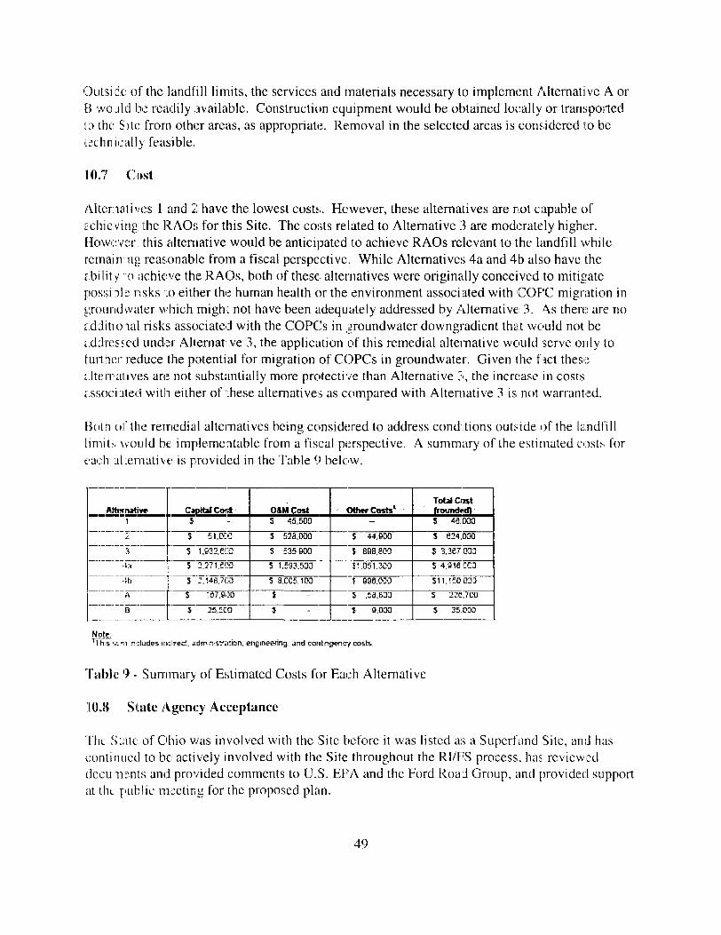
Outside of the landfill limits, the services and materials necessary to implement Alternative A orE5 would be readily available. Construction equipment would be obtained locally or transportedto the Site from other areas, as appropriate. Removal in the selected areas is considered to betechnica l ly feasible.
10.7 Cost
Alternatives 1 and 2 have the lowest costs;. However, these alternatives are not capable ofa c h i e v i n g the RAOs for this Site. The costs related to Alternative 3 are moderately higher.Howr;:vsr, this alternative would be anticipated to achieve RAOs relevant to the landfill whileremain ng reasonable from a fiscal perspective. While Alternatives 4a and 4b also have theE.bil i t y :o achieve the RAOs, both of these alternatives were originally conceived to mitigatepossnb nsks to either the human health or the environment associated with COF'C migration ingroundwater which might not have been adequately addressed by Alternative 3. \s there are noaddit ional risks associated with the COPCs in groundwater downgradient that would not beaddressed under Allernative 3, the application of this remedial alternative would serve only tofur ther reduce the potential for migration of COPCs in groundwater. Given ihe fact thesealterrauves are not substantially more protective than Alternative 3, the increase in costsassociated with either of these alternatives as compared with Alternative 3 is not warranted.
Both of the remedial alternatives being considered to address conditions outside of the landfil ll i m i t - , would be implementable from a fiscal perspective. A summary of the estimated costs foreach ahemative is provided in the Table 9 below.
Afttwiutrve1
'-
3
43
4b
A
El
Capital CostJ
S 51.OZC
S 1.932.KO
S 2.271. SCO
S 2.143,7(3
S T67.900
S 25,fCO
OftMCostS 45.500
S 523.000
S £35.900
5 1.J93.533
S 8.CC5.100
J
J
<Xh*rCost»'-
S 44.KB
\ 898.803
£',05 1,303
f 99B.OCO
S ,53.633
* 9.030
Total Cost{rounded}S 46.000
S 624.000
$ 3.387 OD3
S 4.916.K3
S11.1S0033
3 228.7CO
S 35.030
Note;^Ihis siiii r-:ludes indirect. «dm?usfa:ion. engineering, and contingency costs.
Table ') - Summary of Estimated Costs for Each Alternative
10.8 State Agency Acceptance
The State of Ohio was involved with the Site before it was listed as a Superfund Site, and hascont inued to be actively involved with the Site throughout the Rl/FS process, has revieweddccu.Tiiints and provided comments to U.S. EPA and the Ford Road Group, and provided supportat the public meeting for the proposed plain.
49

Although the State of Ohio has not yet provided a concurrence letter for this ROD, the State hasindicated that it intends to concur with the selection of Alternative 3 and Alternative A for theFord Road Landfill Site. The State of Ohio's concurrence letter will be added to theAdministrative Record upon receipt.
10.9 Community Acceptance
During the public comment period on the Proposed Plan, the community expressed very fewconcerns with the proposed remedy for the Ford Road Landfill. As discussed in theResponsiveness Summary found as Appendix A to this ROD, public concerns focused on dealingwith the current state of the landfill by implementing the proposed remedies, Alternative 3 andAlternative A.
11.0 Principal Threat Wastes
The NCP establishes an expectation that U.S. EPA will use treatment to address principal threatsposed by a site wherever practicable. The term "principal threat" refers to source materials thatare considered to be highly toxic or highly mobile that generally cannot be reliably contained orwould present a significant risk to human health or the environment should exposure occur. TheLNAPL found at Ford Road Landfill could have been termed as a principal threat if left in place.This source, though, can be reliably contained by removing the LNAPL and the surroundingcontaminated media as part of the remedy at the Site. Therefore, the principal threat wastedefinition does not apply to the LNAPL found at the Site.
12.0 Selected Remedy
This section describes the selected remedy and provides U.S. EPA's reasoning behind itsselection. Alternatives can change or be modified if new information is made available to U.S.EPA through further investigation or research. An appropriate range of alternatives wasdeveloped, based upon the initial screening of technologies, the potential for contaminants toimpact the environment, and site-specific RAOs and goals.
12.1 Identification of the Selected Remedy and Summary of the Rationale for itsSelection
Based on the analysis of the nine criteria conducted in the FS Report and summarized in Section10 of this ROD, the selected remedy for the Ford Road Landfill Site is a combination of bothAlternative 3 and Alternative A. These two alternatives represent the best balance of overallprotectiveness, compliance with ARARs, long-term effectiveness and permanence, costs, andother criteria, including State and community acceptance.
12.2 Description of the Selected Remedy
A summary of the selected remedies, Alternative 3 and Alternative A are provided below (SeeFigure 5 and Figure 6 for a conceptual layout):
50

• The cascaded debris on the side slopes of the landfill will be collected and managed on-she. A Waste Management Plan will be developed and approved by U.S. EPA matdetermines what waste will be shipped off-site (if any) and what will be placed back intothe existing landfill or covered by an extended cap. The entire landfill would then be re-graded and appropriately capped to meet all ARARs identified for the She. The capwould men be vegetated to maintain a more "natural" state.
• Norm and south perimeter soil sampling will be performed to ensure mat all ancillarywaste was identified prior to the end of the remedy. This confirmation sampling willhave to meet each COPC's respective RBC before moving on with completing the finallandfill cover (See Tables 4,5,6 and 7 for RBCs).
• A surface water plan will be developed and approved by U.S. EPA and various modelswill be used to ensure that the system is fully functioning and reducing the infiltration ofwater through the landfill. A site water-balance model will be compiled after the remedyis in place to ensure that the cap installation was done properly and is functioning asintended.
• For groundwater monitoring, Ohio's Water Quality Standards, Lake Erie Basin, in OhioAdministrative Code Chapter 3745-1 Outside Mixing Zone Average for Aquatic Life,will be used to ensure that the groundwater entering into the Black River meets theappropriate standard to eliminate the risks to both human health and the environment (SeeTable 10). This monitoring also includes any COPCs identified when sampling theleachate seeps at the Site.
• The area of contaminated soil/sediment in the northeastern comer of the landfill will befully delineated to characterize the extent of contamination. Soil/sediment will men bemanaged on-site to the extent possible. Soil/sediment that is found to be hazardous willbe shipped to an appropriate licensed facility. Soil/sediment mat is not hazardous but hascontaminant levels above RBCs will be placed into the existing landfill. Soil/sedimentthat has contaminant levels below RBCs can be used in the construction of the landfillcover. This soil and sediment area will have to meet each COPC's respective RBC forbom soil and sediment and the TEC for any sediment ECOPCs (See Tables 4,5,6 and 7for RBCs).
• Current streambank inspections downgradient of the northeastern corner of the landfill donot show any evidence of the black staining where contaminant seepage occurred.Confirmatory soil sampling will be performed if any evidence of this is observed at anytime. This will protect and help restore riverine resources to their highest beneficial useand serve to eliminate any risks to human and wildlife population
• Periodic leachate sampling will occur at the areas staked during the RI (USACE Stake).If these areas become regraded or altered during construction activities, periodic checksof potential seeps will be conducted to ensure that no seepage is occurring. Leachate
51

of potential seeps will be conducted to ensure that no seepage is occurring. Leachatesampling will have to meet Ohio's Water Quality Standards, Lake Brie Basin, in OhioAdministrative Code Chapter 3745-1 Outside Mixing Zone Average for Aquatic Life(See Table 11).
• Regular inspections and sampling will occur at the Site. O&M will include annual visualinspections of the Site for 15 years and sampling activities for 15 years. Wells FR-MW-3, FR-MW-4, and FR-MW-6 will be sampled annually for five years for metals andVOCs. Wells FR-MW-1, FR-MW-7, and FR-MW-8 will be sampled quarterly for twoyears and semiannually for the following three years for a full analytical suite. Once theinitial five-year period is complete and if all contaminant levels are found to be belowrisk levels, wells FR-MW-1, FR-MW-6, FR-MW-7, and FR-MW-8 will be sampledannually for an additional 10 years. A full O&M plan will be developed after completionof the Remedial Design phase to incorporate any additional sampling that will berequired.
• Any institutional controls will be put in place at the site as needed, such as deedrestrictions and groundwater use restrictions. Also, signage will be required surroundingthe Site stating that hazardous materials are present until after the remedy has beenimplemented.
• The existing landfill gas monitoring system will be operated and maintained and allappropriate state requirements will be met for the life of the Site.
• Once the remedy has been implemented, the areas on the landfill footprint that hadexisting grasses, plants and trees will be revegetated with appropriate native vegetationthat will not compromise the new landfill cover. The areas within the Site, but not withinthe footprint of the new landfill that had a limited amount of vegetation removed (due toconstruction traffic, soil management areas, etc) during the implementation of the remedywill be revegetated with new shrubs, trees or grasses as approved by the U.S. FJ*A.
12.3 Summary of the Estimated Remedy Costs and Time Required for Implementation
The estimated cost of the selected remedy for the Ford Road Landfill is approximately $3.4million. The design of the remedial alternatives is expected to take approximately one to twoyears to complete and the physical construction of the remedy is also estimated to takeapproximately one to two years to complete. Table 12 and Table 13 show the cost breakdown forboth Alternative 3 and Alternative A.
12.4 Expected Outcomes of the Selected Remedy
The selected remedies for the Ford Road Landfill Site, Alternative 3 and Alternatives A, willachieve the RAOs for the Site. The selected remedies will be protective and are expected to
52

attain ARARs. The following are expected to occur by implementing Alternative 3 andAlternative A:
• Current groundwater levels in the downgradient wells generally concur with Black Riverstages to indicate that upgradient landfill infiltration controls (capping, grading,stormwater management) are functioning properly for the current cap - it is those areasoutside of the current cap on the steep side slopes of the landfill that need to be addressedsince most of the waste material is exposed in these areas. Once the remedy isimplemented, the exposed portions of the landfill waste will be covered and will preventthe infiltration of water through the waste material, preventing any future contaminationof any media.
• Gfoundwater sampling results should show positive results within the initial five yearsampling period. Specifically, metals contamination in the eastern and southeastern wellsshould decline and sampling in the northeastern comer of the site should show no PCB,metals or PAH contamination in the groundwater meaning that surface water to the BlackRiver is not being contaminated.
• The upgradient well (MW-6) should show a lowering water-level trend due to the reducedlandfill infiltration and associated modeling.
• The remedies will be re-evaluated if groundwater sampling data exhibits trends indicativeof remedy failure (upward trends of COPCs) or variable results that indicate uncertaintyin the remedy.
• The selected remedy leaves a majority of the contaminated materials in place at the Site,and requires long-term land-use restrictions on some portions of the Site. Ford RoadLandfill will not be available for unrestricted use and unlimited exposure at thecompletion of the remedial action, and institutional controls will be required.
• After the physical construction period (estimated to be about one to two years), there willbe immediate risk reductions to human and ecological receptors by both the eliminationof the exposed waste material along the side slopes of the landfill for soil and the removalof the hot spot area of PCB contaminated soil and sediment along the Black River. Afterconstruction, there will be immediate benefits to groundwater because the primary sourceof contamination (PCBs in northeastern comer of Site) will be removed, resulting in theremoval of the LN APL source.
134 Statutory Determinations
Under CERCLA Section 121 and the NCP, remedies selected for Superfund sites are required tobe protective of human health and the environment, comply with applicable or relevant andappropriate requirements (unless a waiver is justified) and be cost effective. The followingsections discuss how the selected remedies for Ford Road Landfill Site meet these statutoryrequirements.
53

13.1 Protection of Human Health and the Environment
The current and potential future risks at Ford Road Landfill are primarily due to the presence ofPCBs in the soil, sediment and groundwater in the northeastern corner of the Site and the lead insurface soils on the side slopes of the landfill. Implementation of the selected remedy will beprotective of human health and the environment through the removal of the cascading waste onthe slopes of the landfill (one source of groundwater contamination) and removal of the hot spotarea of PCB contaminated soil and sediment (the other source of groundwater contamination).The site specific RAOs were developed to protect current and future receptors that are potentiallyat risk from contaminants at the Site. The selected remedy will meet the RAOs. The Site willnot be available for unrestricted use and unlimited exposure at the completion of the remedialaction and institutional controls will be required to ensure that the remedy remains protective.
13.2 Compliance with ARARs
Section 121(d) of CERCLA requires that Superfund remedial actions meet ARARs. 8A - 8Cprovides a list of all ARARs that have been identified and will be met under this ROD. Inaddition to ARARs, non-enforceable guidelines, criteria, and standards may be useful indesigning the selected remedy. As described previously in Section 8.2 of this ROD, theseguidelines, criteria and standards are known as TBCs. The selected remedy will comply with theARARs for the Site.
133 Cost Effectiveness
U.S. EPA has determined that the selected remedy for the Ford Road Landfill Site is costeffective and represents a reasonable value for the money to be spent. A cost-effective remedy inthe Superfund program is one whose costs are proportional to its overall effectiveness. Theoverall effectiveness of the potential remedial alternatives for the Site was evaluated in the FS byconsidering the following three criteria: long-term effectiveness and permanence, reduction intoxicity, mobility and volume through containment, and short-term effectiveness. The overalleffectiveness was then compared to cost to determine whether an alternative is cost effective. Ofthe remedial alternatives evaluated for this Site, Alternative 3 and Alternative A (the selectedremedy) provide the highest degree of overall cost effectiveness.
13.4 Five-Year Review Requirements
The NCP requires that the remedial action be reviewed no less often than every five years if theremedial action results in hazardous substances, pollutants or contaminants remaining at the Siteabove levels that allow for unlimited use and unrestricted exposure. Because this remedy willresult in hazardous substances, pollutants, or contaminants remaining on the Site above levelsthat allow for unlimited use and unrestricted exposure at the completion of the remedial action, astatutory review will be conducted within five years after initiation of remedial action to ensure
54

14.0 DoauBcatetimi of Sigifficut Chuges
The Proposed Plan for Ford Road Landfill was released for public comment near the cod of June2006 and die public comment period ran from July 10 through August 9,2006. The ProposedPlan identified Alternative 3 and Alternative A (Enhancement of landfill and addressingcascaded waste and hot spot removal of PCB contaminated area), as the ptefeued alternative forthe Ford Road Landfill. U.S. EPA reviewed all written and verbal comments submitted duringthe public comment period and determined that no significant changes to the remedy, asoriginally identified in the Proposed Plan, were necessary or appropriate.
55

TABLES
56

VoliUI* Ofpanto CompouniltsenzeneC-ieratnnVlry clcr 151:
X
X
•ttalBjyifraEe-wiraiB.Ojnneiioitj'Lcrs'iJWie^z'Dih^fluDrarttrcf cfil' tt l'tjy t p iTva^steenznis,hln{vs::eTea-o;i,r,3-cd!cyr;re
XXX
XX
X
X
XXX
X
X
X X X
WltlllC
or" 24 23f '2S4EHC
rln»:Msr
XX X
X
X
XX
rwi
Lmiru-Imony«fll:TUPi-yilum
nmhrn>K«-n^iC
sruar«!'!rt!.ry
unLr-
:iftj"niiBdlum•c
XX
X
XX
XXX
X
X
X
X
X
X
X
XXX
X
X
XXX
XXX
X
X
X
XXX
XX
X
XXX
X
X
X
Table 3 - COPCs for Ford Road Landfill Site

1AT i ave-aalta tme i 3a,V> i :ancenEF'enorKurs: t*cqucnL:.» (daji&'year/
SFi' cancf scpe facia'- i-na^o-a;"1
'rSlST'"" MI -^"^ '=-r
•jpr;*:^ .' .xeifi- ad Jailed dcrr-aJ factD-
*.5-Hi ' ^crrns! 2t25orp!ior* ^"a^tfcrr £!_?*'--"!'
;T. y:ra"dJ1JKM !nhalattcn raclDr 'FE.= .' Pa-tlrulslc ernteicn factor i.-nr*ifcsil
COnMSIIWW # - - ^ ,^ .. . . .. r ,w. jw^ ^"?s
rcizcCalanlhracrnc= ETZc('a.'py*ene
= --i=Er3!flja-anlrisne5 ETZECfcirtucramne'ie= s;2-etTi*t?>=iwl!ptilhala'.--iiaeTzcfa.'Tanltir.accne
ii3c">3i'' ,2,3-m'ia>Tt-iEA-DCtr 124-2
A-accr 1254.*."itT C
< -i-i:=--ic
?cc«;n
123Chemlrj,' G3t:m;
114
3E1
Ch»m!r^ E>tr:m
111.32E-39
•. mintfiFUunn umffir**?
7.3CE-C1
7 2CE-CO
7.3CE-C17.3CE-C2'.4CE-C27 3C£»CC
7.3CE<1ZJCCE-HIC
Z.CCE--CC1 5OE-CC
L
^VI AMfHU^U^uVlrrt ....
7.3CE-C*7.3CE+CC
7.3CE-C*
7.3CE-C2*.4CE-Ci7.3CE»CC
7.3CE-C12.CCE*CC
iCCE+CC*.ECE»CC
.. **4i UI»4J-tU(F/- - r
7.3CE-Cr
7.3CE*CC7.3CE-C*
7.3CE-C2
1 .-SCE-027.3CE*CC7.3CE-C'2-CCE+CC
2.CCE+CC'.5CE+C'
,;r. .....„- .X ..MAPvtf .,.?#'?a.......
C.13O.13C.13O.13
O.1OC-1ia 13O.14
0.14
O..C3
.-,. ..- ,....wir«B|...3t1- .,.. .
c.asc.agC.S5c.as3.533. S33.39
3.9*3.B-3.SS
•" ^•^vW^r^-^'*.- •
1.33.13
1-3
1S.11D13.131.
3.55
3.551-1
;•) Rrs».-das=a rcnccnlraHani w=-r dev-cpefl uslrc treaiacrtrms -Jo' ca-narea Injcstcn, derr-iii atsD-pttan, ana rfiatton ;part!caate.i cupcsure tarc«-^3i-!nant5 n sal Tier-.'J3EPA CS3S, *SS';i Rtefc.^35Eismcnt GtJdanc" ID-2uperfurc *=arts A and B.
!2j In azcoTlancc *lti JEH.= A (ZCC4i RA&3 Parts, dema, tcxfctr, valuei were i-iy adjusted rcrtfoae clETicate *llh an A5^a» 53%.RBC - Rlit Baasd ConcerS-alJcr.MA - Net avalablc.
1 able 4 - Develoument of Site-specific Risk-Based Concentrations For Carcinogenic Constituents in Soil

iiii — KA i UJI J~l •'-•'--" _j_j^_i td. ' ,^ i .c:^^. i *.LUfl.'l
B1.V .' ij3« weigrit i;*g) _,AT i •2v^^32ir|2 t!r*"^ ''d3y^ ! • n?n-C3nri»r '>EFi'e3CpDS*_re frequency i|dai'5(VC3'''iEDiexaasurs i-raHan :ytai5:
3F.; cancer stpe "actcr ilms'tjj-d; 'RfC.1 -eferE^:e dcse ImgiXa-day;in-sj f ^_> i • 'r-_.*i«-.s i uu_ 1,1 -^ * w**j i
AF r =Mr.-icl adherence ftclar CTi»':r-''-even1iABEa i' den-£l atS3Tt*3i l clcr i;j-xSes,a)
a*. .' :Klr iur*ice e»3iec 'lir-':IRAi' iTiaabnn rate (Ti^'dayi
PEF i1 PartJn.!ate emlisfcr *acter >',m*il!3;
'£
31?Oi;o
eCnerniDii opecii:Chemical opecn:
AM W
C.iChemlcai Specfli
i=CC
2C1 ,22S»CS
ConcWi»«t •"'." •: - . • •-. ~ -ai-rtSsHfeiiAntlr-cr-yAreenfcCadmiumChro-numCcpcerIrc*-ueadManganeseMdtel ;3ak.&e-3afKi"r-ailumArcclor 1242Arcctr-I2&s
Nolac:
RK)t(iaBik» tey|i«.33E-C43.33E-C41.3DE-333.33EH:34.aaE-C23.33E-31
(Si
1.43E-312.DDE-D2E.S3E-CS
2.33E-C52.33E-CS
wo,, .(nMjfco-dart6.CCE-D5i-CCe-34.i.=Ce-357-=CS-351.2CE-3:4-£ce-o:
NA
£-60£-33c- CC£-3*5.JECS-35iJX£-35ZCCS-35
,HiD,|niallBB toy)4.CCE-C43.CCE-C4-.CCE-Ol;L2CE-C«i4.CCE-C33.CCE-C1
MA
'.4CE-C-:2.CCE-C26.£CE<i2.CCE-C52.CCE-C-5
- ABly,,,- •.*.
3.331cn3.3313.331
3.3313.331
«*
3.3313.3313.331
0.14
C.14
.*•>;:.•>.•*****.>. •:C.'SC.55
C..025C.O25C.3C
C.'E
NA
CC4C0.04C-1-oecC.S'C.S'
.u;il.s ^I^^iwefe-i
9.3£.321EG934
6.7-E•4-33 ;ai*,7484Z61.5
3.333.33
!
(1) RI:K-tasca Dcrcertraicns ere cevetcsc usna ns aocrTr-^ Tor carnbma ngestcr, cer—is jcsarpcan, and imaadDn eiqrc-sure to ccfitamfeTartf! in &o<l trmL3EPA '|1 989, 1 931 ) s* As:esH"ert Gul3at:e tc Eupe-Tund. Pa-ta A aid 5.
i~ I In arrrrC-srrr u,1th IJoE^A i;?T>t; B_A'!>^ P.vt E. C'?T"igl ^cTiir.K1 UBKH I vwe~T nnK- ncljj;1f< Vrt*\3i<» rh^mlrBK w ttr ar AB&; > cn«to
i>l RBC fcrleafl repfCier^ tfie L3EPA n-jcr 5 fnitmran ier-eclBIJai 3oa> Tor Rtiiafna Sols.RBC - T.sk Based Ccrc--i1-att3-i.NA- ScSavalatlc.
Table 5 - Development of Site-Specific Risk-Based Concentrations for Non-Carcinogenic Constituents in Soil

I
•».T •: svmsai^s tr—s- '.Javz;? Mr-ar-cer-^.r.'c-^-^-^z-^r- -r-rs" = -cy [is^-yrs-:-
SF / cnnce-" s c-pe- -".ictar f Ttj/lnc*-d;"1
IRSadJ .' a 3 1- adjusted sea r— erS inge&lcn
E-FDadJ .' a ?e- adjusted dema facto*
*.=-?„< arn-* aOM-utiai *-n« en I'j-mesai
cow*********.--!*?:---:'--.-"'- v •• : • • • • • - • • * «..-?>. -<•«:»«
&e-izxM,s:nntlira-Ene&s-izo>:a:py-«;neE»s"iz:o«*a;n j3*TantneneDl3e-Lzc»:a,Ti:anttir3:EncInarrml . 1 .3. J-cc or»TEneAncccr 12S*iN'sen-'c
2SESCSC
Ct-er-!oJ Coecm
5~ i
5€C
c»-«-icaj soccnr
•-<»R» «MivfcB te*>j«/.7j»-«i-ai
T 3C«-CO
7 2C-E-017 2CE-CO7 2C-E-O1
2J3CS-CC1 _£CE-*CO
••gj»» »•«•*• !*•»"• fi iz»ifcl*»««. . -.t.tj«jp- ' -v- » - • 4M**»ifa<w«rs» w^^^^SlT.33&-C- c.-3 3.B9 S.i
~.33E»33 C.^3 D.B9 O 3i
T.33E-C' c.*3 3.B9 22
7 3CE-1-CC C.»3 3.99 O..12
7.33E-C- C.-3 3.B9 3i
2.CCE»CC C-'J 3.B1 11•:.SCE*CC C.C3 3. 95 2.2
»^.c;
Dmlainnanta f. »ol: fram JC EiPA I lS.iSv(Z'.t In -»rcnrCj*"ce *R*i iJGEPA i.T;3D ; RAGS
M/H. — rxc£ Avalatie.
IRGa^J — :EDc Jr RZC'B»V-'t -^ li.EO — EDO xm h ere- :EOc — E^mpcaj'c duralcn i!=til.cM — B yea'-s
&»vc — 3cdy -j»Bi3*n :ciid; — is KBEZir » Ejxpav.r'e dur&ttan (rcildEntla?) •• S3 yeIRQa — 3edtT>ff'Tl nQeartc** rate ;adull;> — -EO r-
w ^-. .„ . .= ^M^. „,...„ .-, . ,.,u. ^^ ...*_... w... v.^. .._ „. ..„„„,., ».. . . _u«^ , _„_,...„,,_ „
Part E, cermal soslrlty val^>^s i*«re ant> adjusted rtr ^f>3se chemicals ifclth an A£^^ * 53^«
R3aV3'*VaM OFOadJ -• ii'cCc x A^c » GAcVEV^c/'i •* |t;Frr*r - SDC'I * AFo. x CL< ii'Eiv\'ai!i• nert
a.-\c — Exhaled sKn surface area i.chiiC'i - 6,633 a— i'o-ay.sr» ETiAi'c — Bcdy -Melgf*? <;cfMl3: * 'E fcQGh'Cdy EOr — Sxpaa«_re duration trsmldentlaf j — 33 jtearx
AFa • Adticref"cc ftsi_1^^' i.a£ .jt]i -D-DT *rv^zf^2. •1 ^ Ejif c&^d SKIT* xur*Acc a/cA i'aduo <• ~*'S,CCC CT^^'-da^
B**S'a • 2o<r^ H-elant ladu!t;i <• T'O KQ
Table 6 - Development of Site-Specific Risk-Based Concentrations for Carcinogenic Constituents in Sediment
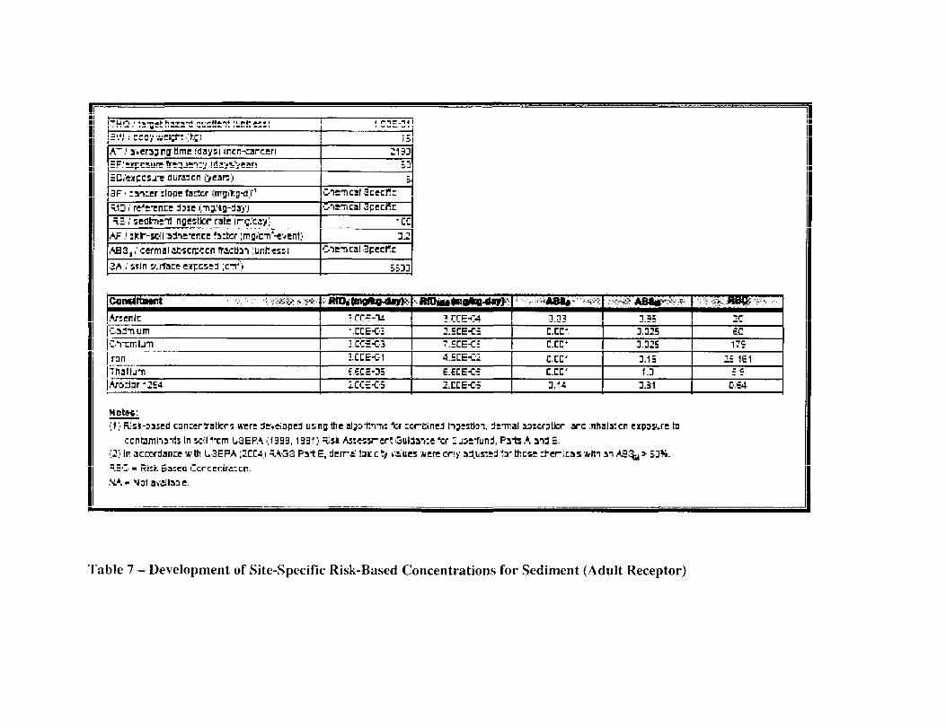
A".1 a-.erajngbme idayn incn-rarcen
fluraacn ijeare)3F i > Ier ilape 1Sc3cr fmgit
T.13 / rs'tTncET.S ,' sedtneT! noestlcr rale
AF / sfc
j i1 cermal jJt-scn:<:cn fracttan lunftessi
•2A i' skin y.rface expcstd ic-n4')
OTETical Scecf r
Gts-rical 3pecnn
-cc
5533
COtWUtWHll . •>. 'i:. •'-.(• -VS*! ,**;
ArsenlcCai-niimClTrclJTiranTnaElj-nAro:Jar42S4
RfD.{mg*<nta»}
1 CC€-3i•ICE-032.CCS-C3
1CCE-G1
6.6CS-35iCC=<-5
IHDiM«BiaiDO-dW»
3.CCE-C42.5CE-Ci7.=CE<:4.5CE-C'!
6.ECE-C52.CCE-C-
^.--.-,.»i*«l»'-->-- i
D.03
C.CC*
C.CC"
C.CC'
c.cc*3.14
x-fe* AB*|p*«
3.353.3253.32E
3.151.3
3.51
mtM>»ii ' * ->• • • *2£60175
1=161
£5C.S4
>;1 ;• Risfc-sased canxryalicrs tueri Sr.eiaped uino ttic aljrtn-n: ice -wttned Itjiitoi, irmal aascfBlfcr arc inhaly.cr KPOBJE laccntamha-rtJ In soil *-cm L3EPA >;1 933, 1 331 ) nisi Aj:«H-ert GuWa-vre "cr ". j^-fund, Pats A aid 5.
i L3EPA ;2CC4;i =1 33 Pa-tE, derri.HC • fiisk Ba:ed 'Icrccniriicn.
MA-
Table 7 - Development of Site-Specific Risk-Based Concentrations for Sediment (Adult Receptor)

-w •"*• '• •• •> - "
TCJC'C Substances Control Ac;{TSCAJ
Votary Action Program(VAP) Generic Numeric^Standards
VA? Property-Specie RiskAssessment Proceaures
,.-ig$^-: .*•"••*•*•" • •-••4DCFR Part 761
OAC 3745-30D-08
OAC 3745-300-D9(R
ARARorTBC
ARAR
T3C
TBC
• • ..... , -. -,.•„, .,«»•,•«•»««»•• ' - . - - . - . ' -
FEDERAL ARARs AND TBCs
Provides regulations for storage, har»3ng,and disposal of materas contarer^ PC3sgreaier than 50 ppm.
STATE ARARs AND TBCs
Provides direct contact so; standards forthe protection of rsyman heairi.
Pro-rfides direct contact so: standards forecologica receptors.
|§fli|: ! :;:.|pJE:'', ,,,... . . . . . . ; ;«;:,.f ,.....,,„,,„„.;..•.. : . . . . . . . . .
Applies to remeees involving excavarjon.
Niay be considered for evaluate*? of ceanop goals.
May be considered for evaluator of cseamrp goals.
Table 8A - Chemical Specific ARARs and TBCs

•11
Regulation
C 53- Water Act
Endangered Species Act
Sta^caras for Owners andOperators of Hazarcojs WasteTrealrrenl, Storage, a"3Cjposa. FacilitesFwnf-vpr>rw 11QRS
Protect" en of Focec- a "s
National Historic and HistoriesPreseAfatwi Acts
Water C ua 1y Slanearcs - AllWatersWater Cua ty Stanea'Cs - 6lac<Rver Drainage Basin
Water Cua/ty Sta.iea.ics - LakeErie Drainage Basin
• • • • "
' -Citation
4DCFR?ar. 13t
16 USC 1531 et seq.50 CFR Fart 200DO CFR Fart 402
4D CFS Part264.1 2 lb]
API TPS P=rf P. Ann A
38 CFR Fit €536 CFR Pan 3 CO16 USC 470
OAC 3745-1-04
OAC 3745-1-27
OAC 374 5- 1-33
ARARorTBC
A n * -*,nrw--,
AuqfiO
ARAR
AP40
ARA=?
ARAR
ARAR
ARAS
• •
Description
FEDERAL ARARs AND TBCsSpeafies water cr.i5 ty cri;eria ror 5 surfacewaters.Req'j res 'Edsra! sgsr.cies ts ensure tfiat theccntinued existence of any endangered orthreatened speces anc thSsJ habitats will not bejejjjdrdii^ by d itr dcfJon.
Landfill facilities within a 100-year flDodplain mustbe cesigned. CQfsttictec. c^*fated, andrraintained to avoid '«asr<xjt-
A r-*ir%rn.r- +-*L*v»*i iBtrf^iin -i fl/^^JKl-iI*™ — *••.-• «i«>U
adverse effe.:ts, rr.n miss potential harni, restore,and preserve natj-a and fi^nefica va*jes of theficcdplan.Rec-j res actors to protect ana presence artifactsand h stare aic Oi'Tural properjes.
STATE ARARs AND TBCsSpecifies vvater c-ja ly cfiteria that all surfacewaters of tr.e state rr/jst nveelSpecifies water cua :y cr^eria that all surface»\aters wthin the Black River crainage bas'r, mustrr.-eelSpecifies water c-^a ty criteria that all surfacewaters within the Lake Erie drainage basin mustmeet
• . . . . .Rationale
Applies to ail sites where surface water is present
Applies to any aotiOii Idhefi ai i/;c i le. Oue-S^-ccn '-infcrmalicn requests regarding the possiblecccurrence of threatened'endangered spe-cies andcriticai habitat were submttec to bon the U.ii. t- sh& Wildlife Servce ; JSFWS) ani fre ODtJR NaturalHeritage rrcgra?n. Respcnses frcn the agenciesare included as Ascencix P.Applies tc cappng and post-excavatcr restoratonactivities.
activities.
Applies to any action taken at the ste. A fj"historic imrest'gatton will be completed before anyalternative is imcementeg.
Applies to all sites where surface water is present.
Applies tc all sites within trie Black Rrver drainagebasin where swfaoe water s present.
Applies to all sites wrtrsn the Lake Erie cranagebasin wftere surface water s present.
iiii
Table 8B - Location Specific ARARs and TBCs

li1
Regulation
Stancaras for Cwners andGjjefatOES uf Hazardous WasteTreajjr«nt, Storage, a"cR ->;nn<ia FacilitiesNational Emission Standards farHazardous Air ?o utantsGcx.upaton5 Safety and KealtriAct; OS HA)
USDOT Placareng and Handling
Resource Conservation aneRecovery Act (RCRA)
Resource Conservation anaRecovery Act (RCRA}
Cean Air Act (CAA)
EPA .MC,'G-90.'C07
•Citation
40 CFR Par: 2€4
40 CFR Part 61
23 CFR Pan 1 SID29 CFR Par. 132)329 CFR Part 1904
40 CFR Part 171
40 CFR Pan 257
40 CFR Pars 257 and25642 U.S.C. 7401 et sec.40 CFR Part 5242U.S.C.740tetsec.
OSWER Directive9355.4-0 1
HO AD «.<•'
!»••»»••• *•»
TBC
FARAR |
ARAR
ARAR
ARAR
.ARAR
TBC
TBC
TBC
. . ,'." ,Description
EDERAL ARARs AND TBCsReq-j rements for placemen? cf a cap overhszarcxjs waste, run-onfrtiji-off prevention,property use restrcticns, and operation arx:maintenance requirements.Req'j rements for ar errissions lasting duringexcavation.Es^b'.ished req'jirerr,-5?rt5 for wcrfter safety 3ndhealth-
"ransportation ana handling reov.re?nents forhazaraois marteras.
Establishes ?eguations regarding critera forclassification cf solid waste cspos& facilities i-,3
jiraKtces.Establisfies starcaros for the management anadisposal of sclid v/aste.
Establishes recu remente for emission rates inaccordance wi:h National Anixent A'r QualityStandarcs 'NAAQS); prowsoes yjceines forminimiz-ng effects of fygtive dust/'airbcme CCOsresulting fron excavation; establishes primaryand seconcary ambient air cua ty standards foremissions.Guidance on remedial actors forSuperfundlandfill sites. Advocates approprate erg ieerngand nsttuticna; cwnrols for material that ismanaged in oace.
• •. •. - ;•• . •: Ji
: ; ' Rationale .
Applies to renec es :-ivolvng capp'rg.
Applies to renettr«s nvolvftg excavation.
W<xj.d apply for any aciion lake" at t** Sfe
Applies to remec«s mialfing trarsport ofhazarcous materals en public roadways.
Applies to res Goafs removec from the Sie.
May be considered as gu aa/ice on t*wmanagement of waste
May be considered for remedial alternatives tnatir»du«te renoval ana'or reocaton of socs.
Way be considered as genera guidance foracthfties at the Site.
iii
T1 l^ I O f~* A *"1 <IL>IC a\^ — rvCiiOn

Regulation Citation ARAR•*.-
orTBC
Description Kationaie
STATE ARARs AND TBCs
Standards for CurrentConstruction of a 1976Cap System
Ohio EPA - DSIWMGuidance #0123 OAC3745-27-09(F)(1995)
ARAR Establishes criteria for materials,construction, and testing specifications fora cap at a landfill.
Applies to remediesinvolving surface coverenhancement.
Identification andListing of HazardousWaste
Ohio EPA Rule 3745-51 ARAR Establishes procedures for identifyingsolid wastes which are subject toregulation as hazardous wastes.
Applies to remediesinvolving excavation.
Acceptance andHandling of HazardousWaste and the ManifestSystem
Ohio EPA Rule 3745-53-20
ARAR Provides standards relating to the use ofthe manifest system and its record keepingrequirements.
Applies to thetransportation ofremoved materials.
Table 8C ^Continued^ - Action Specific ARARs and TBCs

Contaminantof Concern
Groundwaterand/or Surface
Water COC
HumanHealthCOC
EcologicalCOC (SurfaceWater Only)
OMZAstandard (pg/1)
MetalsAluminumAntimonyArsenicBarium
BerylliumCadmiumCopper
IronLead
ManganeseMercuryNickel
SeleniumThalliumVanadium
Zinc
SandGSandGSandG
GGG
SandGG
GGGG
SandGGG
XXXXXXXX
XXXXXXX
XX
X
XX
X
4.500"190150220(g)1
Table 1-9Z
Table 7-9^3004
Table 7-9z
61,000J
.91Table 7-9z
5.0174410
VOCs
BenzeneVinyl Chloride
GG
XX
160930
Pesticides
PCBs (Arochlor1242)
G X .000026"
•
SVOCs
Bis(2-ethylhexl)phthalate
SandG X X 8.4
Table 10 - Groundwater and Surface Water Standards
1 Refer to footnote (g) in Chapter 3745-1 OAC for the Lake Erie Drainage BasinSummary Table
2 Refer to Chapter 3745-1-07, Table 7-9, Statewide Water Quality Criteria for the Protectionof Aquatic Life for Water Hardness Dependent Criteria
3 No OMZA standard available - Ohio EPA Human Health Non-Drinking Standard Used.4 No OMZA or Human Health Standard available - MCL used.

Contaminant ofConcern
Human HealthCOC
Ecological COC OMZA standard(Me/1)
Metab
f\l*nniiwnnAntimonyArsenicBarium
J^fAffumn
CopperIronLead
MtfngflHftfNickel
SeleniumSilver
ThalliumZinc
XXX
X
X
X
XXX
X
XXX
X
4,500*190150220
Table 7-9*Table 7-9*
300*Table 7-9*61,000*
Table 7-9*5.01.31710
VOCs
BenzeneChloroform
XX
160930
Pesticides
BetaBHCDieldrin
Heptachlor
XXX
.46°.056
.0021e
SVOCs
Bis(2<ethylhexl)phthalate
X X 8.4
Table 11 - Letchate Standards
2 Refer to Chapter 3745-1-07, Table 7-9, Statewide Water Quality Criteria for theProtection of Aquatic Life for Water Hardness Dependent Criteria.
3 No OMZA standard available - Ohio EPA Human Health Non-Drinking Standard Used.4 No OMZA or Human Health Standard available - MCL used.c This criterion is based on a carcinogenic endpoint.' 25°C specific conductance values are 1200 micromhos/cm as a maximum and RQQ
mkromhos/cm as a thirty-day average.

JBBl#:••
jisrocnaaa. I mslfHitisraj Csnlrste .liSeea rgSTbaonsi 1 LS S2D,OCE
Xiplal Cootg'Total Indirect CoBtn Mr AriwnafvB 3:
E20.0CO*20,OCO
>;natu«K»t Setupi'Prepara'lon Costs
• 'Ci
CoosructtsrConsructtarheatn ard S;»fetv MoruwtrqFena; I rstal fitter
- Cie:ir:rKi art) Grutttna
- Terpiirary Eircsm'Jl
25
3.003
1.50DIjindfii Cap Conatnidloa F^gadlna. and Fteatorat on CoetB
act- ModrTcaions
- '.eLsed tfsi
Req .?:trxi WasteTPJT CitsHe <TV\t Lancni JrttsAsatteral s jface f graangEosiaiccnsolEiariii-t
Tiaraifiortafllon and >iaposai |T&D( Costs
2E0.020
2,7032.7036.1031,203
72,7336.10D"4,533
LS,
U.L;,
sv
SV
550,802 ^90,50052,5Qg
r.ooa51-5
SS.OOD525.00C525 CD:
S1
S5
51
SO .25
5"512
5117.0CCS6.0CC
S4.5.2CO
M3.0COJ25.3CO
525.CCO51, ECO
S67.ECO532.4CO
S3, 100
513,20053,100
Corrtngert Waste Dsposa 1 LfiTotal Capital Coat for ArtwnsBvs 3-Ail
525.00:
Total Indirect and Capital Coat lor Alternative 3:
iJisratton and Maintenance {OlM} coeiaT«al Estimated indirect and capital coet rcr At
S25.3CO
:H, 932.600:M .35^600
5195,300
(2,831,400
CQr.«r Marrsnsrce A±vC)es (1 every ttx^ years tir 1 E years;
Addltra Saving ( i wells qj3ft=f!> ftr 2 >'e3'B;serrl;3/-nj3ly fa 3 y«n; 3 vwts anntalt)1 *3f 5 years- i *elE
A3dll:;ral LalKratery Ana^te |3 'Aelfe quarler'' Kr 2 years; 3*%ls Eerrlari'uaJy for 3 years; 3 ivelfe anaally *crA^IS arrualy ttr 10 years)
; 3•*eiB seTlan-uaiy I6f 3 ytars; 3 »€!(& anmiolry 'sr 5 years; ^
1 Per Evert SE.OODPTe&grt VMe\ Fac"AT (15 >i&ars g ''SV
US K.ooaF:T5B5rtWOt1flC;C€t
Per'Atel $1,501
Per Evert
F:reKrt Watfi Cictl
F.soa
F'reBert
Total O«M Coats for Alternative 3:Total EBtlmatsd Pre»9nt Wortti Cwt for Msmath'B 3:
Total Essimat&d Present VStarth Cwt for Alternative 3 iRouncledl:
9.11
W-5.ECO
s-5.:co57,300
59.2CO
5101. 7CO
JIQ.TCO
S223.3CC
57.ECO
E156.3CO
*3.367,30€t3,3€7,OCO
Table 12 - Cosl Breakdown for Alternative 3

item1
rofdc1.
Capital
...„., _ . .,_
T ' \+l* 'V.,,-' . U'% ' , ^
" • * > ' ""• • •./•'QiiB^ptoi . . ' ",'"-, SribnlKt
Quadty»,:'f--» <>•*'-***''•
UrtiGwtEatlmated
coatarsfllUlopJ Ccrtrels 3 — ~
Total inartfct costs Tor ijterativs A:>c$0'
CostsConstruction iSstup/Preparafecn Costa2 C'jns-nxitJm SEWpPraparadm Ccete 3 ._ ~ 50ConatRKflon, Removal, and RefHaearrent Costo34.
5.TranspI
ExavattsiEacKtilAddtarai Suiace Hecraflrg
5.4CO5.4CO
11, SCO
CYcrGF
510|15
J02f
5€A,3ffl
J95,acoS2JCC
station and Disposal fT&D) coattiCorthgefCVfiBleDiEpKaf 1 LS «,CO]
Total Capita Coat for AJteiTtative A:Total Indirect and Capital Coat Tor AJtematira A:
AdtrlnkfrsScf) ana Engrvsi'ng |10s'aCsrdrg5ncy>;25%i
To?al Estimated Indirect and Capital Coat for AflernatlvB A:CperatI
So.-2H?J1G7.3CO
$1€7,30C1J15.3CO542,flCO
$255,700on and MaJntMance |0&V} CoataCiMAcllvta 3 — ._
Total O&M Co-ats Tor ijtsiiutive A:Total Estimated Present V/ortn Coat Tor Alternative A:
Total Eatlmated Pre^ant ft'ortti coat fa Att&mattvij A (FtounflsTi :
5c:$0
*25S,7Q(S$M!7,I100
Table 12 - Cost Breakdown for Alternative A

FIGURES
57

i-CJiLJ NOWU LAMCiP-LLCH6
SITC LOCATION IMP
Figure 1 - Site Location Map
Fignfe 2 - Site Layout Map

£2]|Jl-
11 \
-^
^
TiAiieuoit M.eliAiilaiiia/exuoaui. Rome.
Air (Oaaaou*Ralaaaaa)
Subaurfaca Soil*
Surface Solla
STORMRUN
seer
Qroun
t
WATEROFF
— H
>AOC ^ —
>
f
Laachate
Black RfvtjrSurfac* NrVatair
"
ai«oh R*v«r* S«dlm«nt
EMOOttiie) PrfifhwAV*
>
i r
Darmal Contact
nhalatlon
"~ Dermal ContactInaeetlonInhalation
Dermal ContactInaeetlonInhelelinn
Ingeetlon
Dermel ContactInaeellonInhalation
Dermal ContactInaeetlonInhalation
Darmal Contactnoaatlonnhalatlon
Potantlal Raoe|>toie
Ti*a|>«aaai woikei RacieAtloiiAl
1
XXX
XXX
XX
X _
XXX
XX
X
F B
.
1) X danotaa primary •Kpoaur* pathway* Idantrftad In tha human htalth •valuation,
Figure 3 - Conceptual Site Model

WATM TABLE CONTOUH MAPOCTOMK 17, 2009
Figure 4 - Water Contour Map
COVER DETAIL FINAL
Figure 5 - Alternative 3 Conceptual Illustration

f.^rcjfeVdR'' 'iHSK.
^^Jt^vM•vpiH
•-^^^§:VJ5Sssfcfe*
-v**.
:g*?S
ZJ"^~.'
C. 13
,1«M»
AP9KXIMATC •»TPIWi7 oruwcnu.ABORattMTT 51-y.l.A JBf»
r»-« M» SOI. K3B-NC
«i--»»-i* MM ramis wcu.m m -tiwB sum LCCAIOI
VtStUIIJIl
cvcme/o0*1 UK
L.KE
nstr nr *wn
oott*
1 KMKIMT MR TCPOOUIXK HBSf" OT TI<Taw *»ts P%Mpra rr KS W3na»r-r OM
CIM»H£ KM£
Figure 6 - Alternative A Conceptual Illustration

APPENDIX A
58

APPENDIX A
RESPONSIVENESS SUMMARYfor the Ford Road Industrial Landfill Site
This Responsiveness Summary provides both a summary of the public comments U.S.EPA received regarding the Proposed Plan for the Ford Road Industrial Landfill Site andU.S. EPA's responses to those comments. The Proposed Plan was released to the publicnear the end of June 2006, and the public comment period ran from July 10,2006,through August 9,2006. Ohio EPA provided support on the Proposed Plan. U.S. EPAheld a public meeting regarding the Proposed Plan on July 26,2006, at the French CreekNature Center in Elyria, Ohio. Ohio EPA participated in the public meeting, assisted inresponding to questions, and provided support at the meeting.
U.S. EPA received written comments (via regular and electronic mail) and verbalcomments (at the public meeting) during the public comment period. In total, U.S. EPAreceived comments from approximately 6 different people. Copies of all the commentsreceived during the public meeting (including the verbal comments reflected in thetranscript of the public meeting) are included in the Administrative Record for the Site.U.S. EPA carefully considered all comments prior to selecting the final Site remedydocumented in the ROD.
This Responsiveness Summary does not repeat verbatim each individual comment,except in reference to the comments sent in by the Ford Road Group. Rather, thecomments are summarized and grouped by the type of issue raised. The comments fellwithin several different categories: support for the proposed remedy, future use of theSite, concerns during the Site cleanup and one request for a different alternative.
iU.S. EPA received a comment letter dated August 8,2006, submitted on behalf of theFord Road Landfill PRP Group (the Group of companies who signed the Order to pay forthe investigation of the Site). The Ford Road Group has cooperated with Ohio EPA andU.S. EPA to address the Site. The Ford Road Group was represented at the publicmeeting to be available if needed. A summary of the Ford Road PRP Group's commentsand U.S. EPA's responses is included below.
The remainder of this Responsiveness Summary contains a summary of the commentsU.S. EPA received and U.S. EPA's responses to those comments, grouped by category.

L SUPPORT FOR THE PROPOSED REMEDY
The Ford Road Group expressed support for the proposed remedy for the Site(Alternative 3 - Enhancing the cover of the landfill and incorporating cascaded landfilldebris back into die landfill AND Alternative A - Hot spot removal of PCB contaminatedsoil/sediment in the northeastern comer of the Site).
Several commentors expressed support of the cleanup of the Ford Road Landfill She andindicated that the need for protection to human health and the environment from anycontaminants existing on die Site is a high priority.
D. FUTURE USE OF THE SITE
A few commentators requested that whatever cleanup plan was ultimately selected forthis Site, that the plan allow for the Site to be left as "naturally" as possible. The areaaround the Site and on the side slopes of the landfill itself has a mixture of field, scrubshrub, floodplain forest, and upland forest habitat The top of the landfill is a levelgrassed area. Also, it was requested that after the cleanup the Site be left in a way mat itcould possibly be utilized for recreational purposes such as bike paths or multi-purposetrails.
It is anticipated that, during the cleanup, there will be a need to clear some of thevegetation away, especially on the side slopes of the landfill to collect exposed debris, butespecially if the side slopes of the landfill required modification for stability purposes.This being said, it is the Agency's wish to also keep the area in a natural state to allow forrecreational use once the cleanup efforts are complete. Therefore, unnecessary removalof trees, shrubs or other vegetation will not occur at the Site and areas mat have beencleared will be revegetated after the remedy is complete.
ID. CONCERNS DURING SITE CLEANUP
One comment expressed concern with the current state of the Site and possible healtheffects during the Site cleanup. The suggestions were to 1) put signs around the propertywarning about the hazardous nature of the Site; 2) installing a split rail fence around theSite; and 3) receiving notice before cleanup actions occur at the Site so that residents inthe area can keep their doors and windows closed.
The area surrounding the Site will have signs posted that warn of the hazardous nature ofthe Site (both contamination and the physical hazards).
It is not planned to have a split rail fence installed along the Site since it will not keeptrespassers off of the Site and construction traffic will need access to the Site.

U.S. EPA will be sending out mailings throughout the course of this remedy at the Siteand it will be noted that a mailing should occur once a timeframe is decided, informingresidents in the area that earth moving activities will be occurring at the Site so residentscan take precautions if desired.
IV. PREFERENCE FOR DIFFERENT ALTERNATIVE
One comment indicated their preference for Alternative 4b - Groundwater Control -Pump and Treat instead of Alternative 3 stating that this choice would stop landfillpollution from contaminating the nearby Black River. Based upon U.S. EPA'sevaluation of all of the cleanup options, Alternative 3 provided the same level ofprotection to humans and the environment, specifically in regard to the Black River. Thisalternative was originally conceived before completion of the risk assessment to mitigatepossible risks to either the human health or the environment associated with chemicals ofpotential concern (COPCs) migration in groundwater which would not be adequatelyaddressed by the previously discussed alternatives. As the risk assessment andevaluations in this document have shown, there are no additional risks associated with theCOPCs in groundwater downgradient that would not be addressed under Alternative 3.Therefore, the application of this remedial alternative is not warranted from a riskperspective.
V. FORD ROAD LANDFILL PRP GROUP COMMENTS
The Ford Road Group had several comments specific to the Proposed Plan language thatare addressed below:
Comment 1
Statement: In the first paragraph of the Proposed Plan, the document states "The U.S.EPA is proposing to collect and dispose of debris found on the southern and northern sideslopes of the Ford Road Industrial Landfill.
Comment: As stated in the RI/FS it is planned that -waste materials in these areas of thesite will be incorporated under the landfill cap or the cap extended over these areas. TheRI/FS does not envision disposal of these materials and this statement should be revisedto state "excavation and on-site management of debris ".
Response: U.S. EPA agrees that the cascaded debris on the side slopes will beincorporated back into the existing landfill or covered by extending the landfill cap,unless something is found that would require off-site disposal (i.e. drums containinghazardous waste, etc). The Proposed Plan serves as a generalization to inform thepublic and is not intended to supply detailed information relating to the remedy.

Statement: In die second paragraph, referring to Alternative A, die document states Theproposed cleanup of this soil area would involve digging it up and transporting it off-siteto another landfiU facility".
Comment: This broad statement assumes that all soil excavated in this area will betransported off-site for disposal The RJ/FS states that non-impacted surface soil will beremoved, stockpiled and characterized. Soil that is demonstrated to be non-hazardous ormeets required standards would be used either in construction of landfill coverimprovements or placed under the existing cap within the landfill While some of thesoils to be excavated are contaminated, to some extent, they may be classified asremediation wastes under RCRA ARAR. not as hazardous waste. U.S. EPA policy forCERCLA includes a preference for on-site management of waste and the ROD shouldstate that "contaminated soil and wastes will be managed on-site, to the extent possible".
Response: US. EPA agrees that ft fa likely that lot all soil/sediment wffl need to beshipped off-she for disposal. However, any materials that are foud to be havehazardow levels of coatanafaiauts wffl aeed to be shipped off-site to an appropriatedisposal facility. Material that b foaad to have contamination above RBCs, botbelow hazardow levels cma be placed wHhhi the existing landfill and materials(band to have leveb below RBCs caa be used ia the creation of the cover of theiMdfin Again, the Proposed Plaa serves as a generalization to inform the publicaad is «ot intended to sapply detailed iaformation relating to the remedy.
Comments
Statement: On page 2, fifth paragraph, the Proposed Plan states "Browning-Fenis"disposed of chemicals, heavy metals, sanitary sewage wastes, paint sludges and smallquantities of unknown hazardous waste".
Comment: If small quantities of "unknown " waste were disposed in the landfill, itcannot be stated that these wastes were hazardous.
Response: The statement above was taken directly from the Health ConsultationReport generated by the Ohio Department of Heath. The Health ConsultationReport abo stated that "Harshaw Chemicals, a subsidiary of Gntf Ofl Company,seat more thai 700 teas of hazardous materials to the Ford Road Landfill from1950 until 1974. Materiab seat iadaded heavy metals, other inorganic substances,aad mbceflaaeous catalysts mad iasectkides (OEPA 1980).** It b very likely that theFord Road Landfill did accept hazardous waste during some time in its period ofoperation, although BFI may have only play a smaD role in contributing to theamount of hazardous waste present in the landfill

Comment 4
Statement: The last paragraph of page 2 and the first paragraph of page 3 states"Sampling showed the soil on the northern and southern slopes where the waste hasspilled out contains high levels of organic compounds, 3 PCBs and metals. Undergroundwater samples also showed widespread metal and PCB contamination on the northeasterncomer of the Site."
Comment: It is misleading to state that PCB contamination is "widespread" in thenortheastern corner of the Site. PCBs were detected in groundwater in one small area ofthe site. This contamination appears to be isolated and currently cannot be attributed toflow from the landfill based on the lack of PCBs in leachate analyses. The term"cascaded" or a similar term, seems more appropriate that "spilled out".
The term "high levels " and "dangerous " are subjective and may be unduly alarming.EPA should make more of an effort to put site concentrations and risks in perspective.This was done by EPA at the July 26, 2006 public meeting through responding toquestions raised by residents. As indicated by EPA that meeting, there is no imminentrisk and no need for emergency/interim actions.
Also, the statement on the bottom of page 1 indicating that semi-volatile organiccompounds dissolve in water and evaporate easily is questionable.
Response: U.S. EPA agrees that the PCB contamination is not widespread acrossthe Site and is in fact in a very limited area of the Site. Also, U.S. EPA agrees thatthere are no "emergency level risks" at the site that warrant immediate action.Finally, the wording in the Proposed Plan relating to semi-volatile compoundsdissolving in water should not been included.
Comment 5
Statement: In paragraph 8, page 3, the projected cost for Alternative 1 - No FurtherAction is shown as $0. : . . - - .
Comment: The RI/FS estimate for Alternative 1 is $46,000.
Response: The Proposed Plan is incorrect and should state $46,000.
Comment 6
Statement: The discussion of Alternative 3, paragraph 10, page 3, states "If to the wasteon the slopes is found to be too hazardous, it would be moved to an approved disposalfacility somewhere else".
Comment: This statement "too hazardous " is a general statement that should becorrected. It is expected that most, if not all, of this material will be incorporated under

the landfill cap. As stated in a previous comment, the ROD should specify that"contaminated soil and wastes will be managed on-site to the extent possible". Ifmaterials are to be disposed off-site, the ROD should discuss the process that will beused to make this determination, in accordance with CERCLA guidance, policies andARARs. y this is not known at present, the ROD should state that waste materials will bemanaged in accordance with a Waste Management Plan to be developed as part of theremedial design and approved by U.S. EPA.
Response: Agate, the Proposed Flu serves as a generalization to inform the publicsad fa) mat onesided to supply detailed information relating to the remedy. Thestatement "too hazardous" was simply nsed to indicate what might need to beshipped ofMte without going into additional details relating what those
The suggestion of creating a Waste Management Plan was incorporated into theROD since there is a chance for a small amount of cascaded debris to be shipped off-site to an appropriate facflhy.
Comment?
Statement: The third paragraph, page 4, states that "It is planned mat this contaminatedsoil and mud would be transported off-site to another landfill facility".
Comment: Materials excavated as part of Alternative A should be managed on-site to theextent possible and onfy disposed off-site if required by ARARs, characteristics of thematerial, and concentrations, require off-site disposal. This broad statement wouldrequire off-site disposal of all material from Alternative A and should be clarified. TheROD should state that all materials excavated as pan of Alternative A willbe managed,on-site to the extent possible. EPA should avoid the use of non-technical term "mud" infavor of "soil" or "sediment".
Response: The Proposed Plan b a non-technical document that mnst be presentedin a way that fa understandable to individuals, both technical and non-technkaLPlease also refer to Comment 2 for additional response information.
Comment 8 — Cover Materials
The RI/FS specifies that low permeability soil will be placed over areas where currentcover is less man 2-feet This will comply with the ARAR for the 1976 cap. However,while this type of cap can be constructed, it could require the removal of all trees andshrubs within the landfill footprint Also, it will limit the design process and should berevised to provide more flexible language and allow the potential for innovation andalternative technologies. The ROD should state that "the cover will consist of 2-feet oflow permeability soil.. .or a cover that is equally protective and approved by the U.S.EPA**. This language would allow the design to potentially include, geosynthetic andgeocomposite materials in certain areas, if necessary, and possibly less cover.
Response: The ROD does contain language that states "the cover will consist of 2-feet of low permeability soil or a cover that is equally protective and approved bythe U.S. EPA" in order to allow for possible innovative cover enhancements.However, all of the work performed out at the Site will comply with both State andFederal ARARs unless it is determined by the Agencies that a provision can bemade that is more beneficial to the project and equally protective of human healthand the environment
Comment 9 - Cover Materials
The RI/FS assumes that all vegetation will be removed from the landfill "footprint", astypically required for conventional landfill capping. However, this statement does notallow consideration of leaving large trees that contribute to the natural setting and mayhave value if the decision is made in the future to develop the Site as some type of park.The trees also appear to promote slope stability and limit soil erosion potential. For thosereasons, the PRPs concur with the comment voiced by the Site owner (MetroParks) at theJuly Public Meeting that the vegetation/trees should remain in a natural state to the extentpossible. ROD language should allow consideration of an alternative, such as a limitedphytocap, that might leave trees largely intact. If considered, this type of capping wouldbe evaluated as part of the remedial design and would have to be approved by U.S. EPAbased on a demonstration of effectiveness.
Response: The U.S. EPA disagrees with the suggestion to leave large trees in placeon the side slopes of the landfill. In order to provide an effective landfill cap, theentire landfill must be adequately covered and it must be ensured that trees andshrubs with large root systems do not compromise the integrity of the cap. Thatbeing said, U.S. EPA agrees that the area should be left as naturally as possible andhighlights that the trees and shrubs that are on the Site but not within the footprintof the landfill itself will remain in place to the degree possible. The cap itself will berevegetated with materials appropriate for landfills after the enhancements arecomplete so that it provides a more natural setting and areas outside of the landfillfootprint that had vegetation removed for remedy implementation purposes will berevegetated with new trees, shrubs and other flora.
Comment 10 - PRP Group
During the July Public Meeting, U.S. EPA listed the respondents that signed the AOC asthe Ford Road Landfill PRPs. While this Group does comprise some of the PRPs,additional PRPs have been identified to the U.S. EPA. A list of additional PRPs wasmost recently provided to the U.S. EPA on Aug. 1,2006. Special Notice letters should besent to the additional PRPs and these PRPs should be included in the ROD, along withthe City of Elyria and the MetroParks, which were identified as PRPs by the U.S. EPA.
Response: U.S. EPA is aware that there are potentially responsible parties otherthan those who signed onto perform the investigation work for Ford Road Landfill.

After the covpfctiofl of the ROD, U.S. EPA will begta dfeouriou of tke mat pkaseof the project that eoBcens •cgotiatiag the deuap work with poteatiaOy

APPENDIX B
59

U.S. •AL pRoracnovRKMKDIAL ACTIOW
RECORDFOR
FORD ROAD LABDFILL SITSKLYRIA, LORATJI COQVTY, OHIO
07/02/02
06/12/03
11/05/03
03/05/04
04/02/04
04/23/04
06/08/04
06/16/04
07/00/04
U.S. BPA
Ohl, M.,U.S. BPA
Gereby, C.Ohio EPA
NcCune, H.,Blasland,Bouck & Lee,Inc.
NcCune, H.,Blasland,Bouck fc Lee,Inc.
Collier, D-.U.S. BPA
Collier. D.,U.S. BPA
Collier, D.,U.S. BPA
HestonSolutions,Inc.
ORiozno.JULY 24, 2006
RBCIPI
Respondents
Steerman, P.,SteermanEnvironmentalManagement &Consulting, LLC
Steerman, P.,SteermanBnvironroenta1Management &Consulting, LLC
Collier, D.,U.S. EPA
Collier, D.,U.S. EPA
Steerman, P.,SteermanEnvironmentalManagement &Consulting, LLC
Steerman, P.,SteermanEnvironmentalManagement &Consulting, LLC
Steerman, P.,SteermanEnvi rorunen t a 1Management &Consulting, LLC
U.S. EPA
TITLE/ PACKS
Administrative Order byConsent for the FordRoad Landfill Site
Letter re: RI/FS WorkPlan Approval withConditions for the FordRoad Landfill Site
Letter re: AdditionalSampling at the FordRoad Landfill Site
Preliminary Site Char-acterization Suumaryfor the Ford RoadLandfill Site
Letter re: PreliminaryResponse Actions andRemedial Technologiesfor the Ford RoadLandfill Site
Letter re: PreliminaryResponse Actions andRemedial TechnologiesLetter for the FordRoad Landfill Site
Letter re: Response toPreliminary Site Character-ization Summary for theFord Road Landfill Site
Letter re: ProposedAdditional MonitoringWell Locations at theFord Road IndustrialLandfill Site
Community InvolvementPlan for the Ford RoadIndustrial Landfill Site

FORD ROAD LANDFILLADMINISTRATIVE RECORD
PAGE 2 OF 3
NO.
10
13
14
15
17
18
DATE
07/21/04
11 09/30/04
12 02/28/05
03/31/05
04/27/05
05/20/05
16 08/11/05
10/05/05
10/20/05
AUTHOR
McCune, W.,Blasland,Bouck & Lee,Inc.
McCune, W.,Blasland,Bouck & Lee,Inc.
McCune, W.,Blasland,Bouck & Lee,Inc.
McCune, W.,Blasland,Bouck & Lee,Inc.
Collier, D.,U.S. EPA
Collier, D.,U.S. EPA
Collier, D.,U.S. EPA
McCune, W.,Blasland,Bouck & Lee,Inc.
Collier, D.,U.S. EPA
RECIPIENT
Collier, D.,U.S. EPA
Collier, D.,U.S. EPA
Collier, D.,U.S. EPA
Collier, D.,U.S. EPA
Steerman, P.,SteermanEnvironmentalManagement &Consulting, LLC
Steerman, P.,SteermanEnvironmentalManagement &Consulting, LLC
Steerman, P.,SteermanEnvironmentalManagement &Consulting, LLC
Collier, D.,U.S. EPA
Steerman, P.,SteermanEnvironmentalManagement &Consulting, LLC
TITLE/DESCRIPTION PAGES
Letter re: SupplementalActivities to Assess LNAPLObservation in MW-1 atthe Ford Road LandfillSite
Letter re: Responses toU.S. EPA Comments on thePreliminary Site Character-ization Summary for theFord Road Landfill Site
Letter re: Second FSDeliverable PreliminaryRemedial Alternativesfor the Ford Road LandfillSite
Letter re: Second RiskAssessment Deliverablefor the Ford Road LandfillSite
Letter re: Comments onthe Second Risk AssessmentDeliverable for the FordRoad Landfill Site
Letter re: ResponseLetter to Second RiskAssessment Deliverablefor the Ford Road LandfillSite
Letter re: Comments onthe June 2005 RI/FS forthe Ford Road LandfillSite
Letter re: Responsesto U.S. EPA Commentson the RI/FS for theFord Road Landfill Site
Letter re: Comments onthe Ford Road LandfillGroup's Response toComments on the RI/FSfor the Ford Road LandfillSite

IORD BOM) LAHDVILLXSXKATXVX RKCORD
PAGE 3 OF 3
19 02/23/06
AUTHOR
Schmidt, J.& M. Tukel.Ohio EPA
20 03/00/06 Blasland,Bouck & Lee,Inc.
21 04/17/06 Collier, D.fU.S. BPA
22 05/10/06 Collier, D.,U.S. BPA
Mcrpinrr
Martin, J.,Lorain CountyMetropolitanPark District
U.S. EPA
Steerman, P.,SteennanEnvironmentalManagement &Consulting, LLC
Steerman, P.,SteermanEnv i ronment a1Management &Consu11 ing, LLC
TTTLK/1 PACTS
Letter re: ExplosiveGas Monitoring PlanCertification Concurrencefor the Ford Road LandfillSite
Renedial Investigation/Feasibility Study Reportfor the Ford Road LandfillSite
Letter re: Cooments onthe Second Version of theDraft RI/FS for the FordRoad Landfill Site
Letter re: Approval ofRI/FS for the Ford RoadIndustrial Landfill Site

U.S. ENVIRONMENTAL PROTECTION AQENCYREMEDIAL ACTION
NO.
1
DATE
06/00/06
07/26/06
08/08/06
08/08/06
08/25/06
ADMINISTRATIVE RECORDFOR
FORD ROAD LANDFILL SITEBLYRIA, LORAIN COUNTY, OHIO
UPDATE #1SEPTEMBER 26, 2006
Hart, J.,City ofElyria
Steerman, P.,SteermanEnvironmentalManagement& Consulting,LLC
Residents
Volkmer, D.,WestonSolutions,Inc.
RECIPIENT
Public
Collier, D.,& R. Gonzalez,U.S. EPA
Collier, D.,U.S. EPA
Collier, D.,U.S. EPA
Gonzalez, R.,U.S. EPA
TITLE/DESCRIPTION PAGES
U.S. EPA Fact Sheet: 10"EPA Proposes Cleanup Plan;Requests Public Comment"
Ford Road Industrial Land- 2fill Site Comment Sheet
Ford Road Landfill PRPGroup Comments on U.S. EPAProposed Remedy for theFord Road Site
Electronic Transmittals 4re: Public Comments to theProposed Plan for the FordRoad Industrial LandfillSite
Public Meeting Transcript 68for the July 26, 2006Meeting re: U.S. EPA'sProposed Cleanup Plan forthe Ford Road IndustrialLandfill Site w/Cover Letter