Embed Size (px)
Citation preview
FINAL REPORT 30 September 2017
Prepared by: Bewsher Consulting Pty Ltd 6/28 Langston Place, Epping NSW 2121 Australia P O Box 352, Epping NSW 1710 Australia Telephone: (02) 9868 1966 Ref: J2255R_4.docx Email: [email protected] Internet: http://www.bewsher.com.au Published by: The Murray-Darling Basin Authority Postal Address: GPO Box 1801, Canberra ACT 2601 Telephone: (02) 6279 0100 international + 61 2 6279 0100 Facsimile: (02) 6248 8053 international + 61 2 6248 8053 Email: [email protected] Internet: http://www.mdba.gov.au
Independent Review of
Hydrologic Modelling for SDL Adjustments
MURRAY–DARLING BASIN AUTHORITY
Copyright All material and work produced for the Murray-Darling Basin Authority constitutes Commonwealth copyright. MDBA reserves the right to set out the terms and conditions for the use of such material. With the exception of the Commonwealth Coat of Arms, photographs, the Murray-Darling Basin Authority logo or other logos and emblems, any material protected by a trade mark, any content provided by third parties, and where otherwise noted, all material presented in this publication is provided under a Creative Commons Attribution 3.0 Australia licence.
http://creativecommons.org/licenses/by/3.0/au © Commonwealth of Australia (Murray-Darling Basin Authority) 2017.
Title: Independent Review of Hydrologic Modelling for SDL Adjustments
Source: Licensed from the Murray-Darling Basin Authority under a Creative Commons Attribution 3.0 Australia Licence
The Murray-Darling Basin Authority does not necessarily endorse the content of this publication.
As far as practicable, material for which the copyright is owned by a third party will be clearly labelled. The Murray-Darling Basin Authority has made all reasonable efforts to ensure that this material has been reproduced in this publication with the full consent of the copyright owners. Inquiries regarding the licence and any use of this publication are welcome by contacting the Murray-Darling Basin Authority.
Disclaimer The views, opinions and conclusions expressed by the authors in this publication are not necessarily those of the Murray-Darling Basin Authority or the Commonwealth. To the extent permitted by law, the Murray-Darling Basin Authority and the Commonwealth excludes all liability to any person for any consequences, including but not limited to all losses, damages, costs, expenses and any other compensation, arising directly or indirectly from using this report (in part or in whole) and any information or material contained within it. Accessibility Australian Government Departments and Agencies are required by the Disability Discrimination Act 1992 (Cth) to ensure that information and services can be accessed by people with disabilities. If you encounter accessibility difficulties or the information you require is in a format that you cannot access, please contact us.
Model Review for SDL Adjustment Process i Bewsher Consulting Pty Ltd
Final Report ― 30 September 2017 J2255R_4.docx
TABLE OF CONTENTS Page
1. INTRODUCTION ............................................................................................................ 3 1.1. Background to this Review ..................................................................................... 3 1.2. Terms of Reference for this Review ....................................................................... 3 1.3. Qualification to the Extent of this Review ............................................................... 4 1.4. Review of Hydrological Modelling Frameworks (Sept 2016) ................................... 5 1.5. Activities Undertaken and Documents Reviewed ................................................... 6
2. PREPARATION OF THE BENCHMARK MODEL (SDLBM) ............................................ 6 2.1. Overview of the Benchmark Model ........................................................................ 6 2.2. Schedule 6 of the Basin Plan ................................................................................. 7 2.3. ‘Mandated’ Changes .............................................................................................. 7 2.4. Changing the Benchmark – Governance ............................................................... 8 2.5. Non-Mandated Changes ........................................................................................ 9
3. PREPARATION OF THE SDLA MODEL (SDLA)............................................................ 9 3.1. SDLA Overview ..................................................................................................... 9 3.2. Default Method .................................................................................................... 10 3.3. Reliability of Supply .............................................................................................. 11 3.4. Environmental Outcomes Scoring ........................................................................ 12 3.5. Limits of Change .................................................................................................. 15 3.6. Application within the Modelling Framework......................................................... 16
4. ASSESSMENT OF SDLA MODELLING....................................................................... 16 4.1. Representation of SDLA Projects in SDLA............................................................ 16 4.2. Endorsement of Projects by BOC ........................................................................ 17 4.3. Reconciliation of Adjustments in 2024.................................................................. 17 4.4. Preservation of the SDLBM and SDLA Models ....................................................... 18 4.5. Response to Terms of Reference ........................................................................ 18
5. SUMMARY AND CONCLUSIONS ................................................................................ 20
Model Review for SDL Adjustment Process ii Bewsher Consulting Pty Ltd
Final Report ― 30 September 2017 J2255R_4.docx
FIGURES
FIGURE 1: — Iterative Process to Determine the Supply Contribution ............................ 11 FIGURE 2: — Environmental Assets ............................................................................... 14
TABLES
TABLE 1 — Reliability of Supply Metrics used within Valleys in the Southern Connected System ................................................................................... 13 TABLE 2 — Response of Review to Terms of Reference ............................................ 19
APPENDICES
APPENDIX A: — Terms of Reference for this Review APPENDIX B: — Principal Documents Examined During This Review APPENDIX C: — SDLA Projects
Model Review for SDL Adjustment Process 3 Bewsher Consulting Pty Ltd
Final Report ― 30 September 2017 J2255R_4.docx
1. INTRODUCTION
1.1. Background to this Review
The Water Act 2007 (Cth) legislates for the preparation and implementation of a Murray-Darling Basin Plan. The Plan sets legally enforceable limits on surface and groundwater use known as sustainable diversion limits (SDLs) that are consistent with the environmentally sustainable level of take. The Plan adopted by the federal water minister in November 2012 defines a baseline diversion limit (BDL) and specifies a basin-wide reduction in diversions by 2750GL/yr below the BDL level in order to achieve the SDLs. The Plan provides for the Authority to propose adjustments to the SDLs1 and to carry out reviews of the Basin Plan.2 Hydrological modelling has a key role in these adjustment and review processes. Because of its critical importance, the Authority has commissioned various independent reviews of the modelling work as it has progressed. In September 2016 an independent review of the hydrological modelling framework which had been used at that time in the SDL Adjustment (SDLA) and Plan Review processes was undertaken. The results of this review which are detailed in Section 1.4 endorsed the continued use of the modelling framework. The modelling framework is currently being used to quantify the SDLA that would result from implementation of a package of measures comprised of supply3, efficiency4 and constraint5 projects within the southern connected system.6 This present review has been commissioned to determine whether the current modelling process, model data and assessment framework are:
(a) technically sound for the purposes of determining the SDLA amount; and
(b) compliant with the Basin Plan and in particular Chapter 7 which stipulates the method to be applied in calculating the SDLA amount.7
1.2. Terms of Reference for this Review
The terms of reference (ToR) for this review are reproduced in Appendix A.
In essence, the process of determining a SDLA amount involves a comparison of two different model runs comprising:
1 Refer Chapter 7 of the Basin Plan and Section 23 of the Act.
2 Refer subsection 6.06 of the Basin Plan and subsection 50(2) of the Act.
3 Supply measures directly generate an increase in SDLs (i.e. reduced water recovery) and are predominantly environmental
works, changes in river operations or evaporative savings. 4 Efficiency measures provide more water to the environment by reducing consumptive use in ways that will not lead to negative
social and economic impacts. Efficiency measures include, for example, improving the effectiveness of on-farm irrigation or piping delivery channels in irrigation areas. 5 Constraints are principally impediments to flow delivery, e.g. channel capacity constraints to avoid overbank flows and third
party impacts. The removal of constraints can improve the ability to deliver environmental water outcomes and they can therefore interact beneficially with supply and efficiency measures. 6 The southern connected system refers to the Murray River, the Darling River from Menindee Lakes and downstream, and the
Murrumbidgee and Goulburn-Loddon-Broken-Campaspe systems (and excludes the Lachlan and Wimmera systems which are normally disconnected from their downstream river systems). 7 Schedule 6 details the specific features of the method to be applied (unless the Authority and the Basin Officials Committee
agree to use another method – which the reviewer understands has not occurred). This is referred to as the ‘Default Method’.
Model Review for SDL Adjustment Process 4 Bewsher Consulting Pty Ltd
Final Report ― 30 September 2017 J2255R_4.docx
(a) Benchmark Conditions (Model SDLBM) – Benchmark conditions are described in subparagraph 7.02 of the Basin Plan.8 The Benchmark model reported in the Basin Plan (i.e. Run 847) was the baseline model9 with water recovery of 2,800 GL/year (basin-wide) and an environmental watering strategy. Nevertheless the Basin Plan recognised the need to refine the benchmark model with various ‘mandated’ and ‘non-mandated’ changes.10 This refined benchmark model is referred to as SDLBM; and
(b) SDLA Conditions (Model SDLA) – These conditions include the package of notified11 SDLA measures and have the SDL (and the quantum of water recovery) adjusted by an iterative process that ensures there are equivalent environmental outcomes and no detrimental impacts on the reliability of water supplies relative to SDLBM. This adjustment to the SDL is referred to as the ‘supply contribution’.12 Schedule 6 of the Basin Plan sets out the Default Method for the calculation of the supply contribution. The model configuration which maximises the supply contribution and remains consistent with the Default Method is referred to as SDLA.
Consequently this review has focussed on the modelling processes, model data and assessment
framework used in preparing the SDLBM and SDLA models.
1.3. Qualification to the Extent of this Review
When conducting model reviews there are various levels of investigation and checking that can be undertaken. A review can sometimes examine the model software and interrogate various computer files comprising the model inputs and outputs. These types of reviews are sometimes referred to as model ‘audits’ and may involve re-running of the model software on the reviewer’s computer and independently confirming the accuracy of all model inputs and outputs. This review is not an ‘audit’ and has been conducted on the basis that the various documents prepared by the MDBA and the jurisdictions accurately portray the hydrological facts. Further the reviewer has found in all his dealings with the MDBA staff that the discussions have been open and frank and there is no reason to believe any relevant information has been withheld. The current review is one of various independent reviews of the Basin Plan processes and modelling frameworks that have been carried out. These include a separate review of the SDLA hydrological modelling framework undertaken in September 2016. The findings of that review are summarised in Section 1.4. Consequently it is not within the terms of reference
8 This specifies that “benchmark conditions of development means the conditions of development that were assumed in the
benchmark model described in Schedule 6 (of the Basin Plan) when the model was used to set the unadjusted SDLs for the Basin Plan …. These conditions include the infrastructure, rules and practices that were assumed in the benchmark model, including certain measures that were not yet in effect but were expected to be in place by 2019, including as a result of investments that the Commonwealth is committed to funding and are expected to recover the equivalent of at least 600 GL of water per year”. 9 The baseline model (i.e. Run 845) simulates water sharing arrangements and levels of infrastructure as at June 2009 in
accordance with Schedule 3 of the Basin Plan. It runs for the 114 year period from 1985 – 2009. 10
Refer Clause S6.02 of Schedule 6 of the Basin Plan. 11
Paragraph 7.12 of the Basin Plan specifies the formal process by which “the Basin Officials Committee may, by 30 June
2016, notify the Authority of 1 or more supply measures or efficiency measures that, in the view of the Committee, should be taken into account in proposing adjustments …”. There is also a process where “additional efficiency measure(s) may, after 30 June 2016 but on or before 31 December 2023, be notified to the Authority”. In addition, in 2016, the Basin Plan was amended to provide for a second notification by 30 June 2017. Paragraph 7.13 specifies that “the Authority must maintain a register of notified measures and additional efficiency measures …”. 12
Paragraph 7.15 of the Basin Plan
Model Review for SDL Adjustment Process 5 Bewsher Consulting Pty Ltd
Final Report ― 30 September 2017 J2255R_4.docx
of this review to examine the veracity of the modelling framework or to conduct a model ‘audit’ (nor does the reviewer consider that this level of review or ‘audit’ is necessary). This review has focused on the processes that have been undertaken by MDBA staff in preparing the SDLBM and SDLA models. The review activities have centred on personal interviews with modelling staff and examination of the relevant SDLA documentation prepared by the Authority. Whilst a range of documents have been examined and are listed in Appendix B, the two reports listed at the end of Section 1.5 are of most relevance to the preparation of the SDLBM and SDLA models. Consequently greater attention has been given to these two documents. The qualifications to the scope of the current review which are listed above are confirmed in the ToR that state:
“the scope of the review is limited to how the benchmark conditions and supply measures are represented in the model through the review of the reports documenting the model representation. It does not include the suitability of the overall approach for calculating the SDL adjustment that has previously been reviewed, including:
the 24 River-system models that cover the Murray-Darling Basin;
the Integrated River System Modelling Framework;
the Ecological Elements method developed by the CSIRO-led project team;
the method for determining the Environmentally Sustainable Level of Take; and
the SDLA modelling framework and modelling processes”.
1.4. Review of Hydrological Modelling Frameworks (Sept 2016)
In September 2016 an independent review was undertaken of the Authority’s hydrological modelling frameworks which were being used at that time to support the process of SDLA and the Northern Basin Review.13 Amongst that review’s key findings were the following which are relevant to the current review:14 (a) the modelling frameworks that are being used for the SDLA project are largely based
on the framework used during the preparation of the Basin Plan. The credentials of this framework have already been established during the preparation of the Basin Plan;
(b) no key weaknesses in the modelling frameworks or approaches were identified that would prevent them from being used for the SDLA process in a manner consistent with the requirements of the Basin Plan. Accordingly the review endorsed the continued use of the modelling frameworks to support the SDLA project;
(c) the methods applied to model outputs to calculate flow statistics were reviewed. Those methods were based on long established procedures that have been used during the preparation of the Basin Plan and as part of numerous other modelling projects. The review considered those methods to be technically sound and appropriate for the purposes of the SDLA project;
13
The Northern Basin Review is described in Section 6.06 of the Basin Plan. 14
Refer document B17 in Appendix B.
Model Review for SDL Adjustment Process 6 Bewsher Consulting Pty Ltd
Final Report ― 30 September 2017 J2255R_4.docx
(d) Specifically in respect of the SDLA project, the review also identified that:
the modelling framework and modelling processes were capable of being applied in a manner compliant with the Default Method specified in Schedule 6 of the Basin Plan and for determining the supply contribution under the Plan;
the modelling methods used to produce the environmental demand timeseries (i.e. event selection and event removal) were technically sound and repeatable and can be used consistently between the SDLBM and SDLA models;
the methods used to analyse model outputs to determine impacts on supply reliability are technically sound and are capable of appropriately evaluating the requirements of the Basin Plan.
1.5. Activities Undertaken and Documents Reviewed
The current review was undertaken in late August and early September 2017. It included meetings, telephone interviews and correspondence with the following MDBA personnel:
(a) Matthew Bethune, Senior Director, Water Resources, MDBA; (b) Jong Lee, Director, Basin Plan Modelling, MDBA; and (c) Anjuma Khan, Water Resources Modeller, Basin Plan Modelling, MDBA.
At the commencement of the review the MDBA made available a range of documents which are listed in Appendix B. The two key reports which are the focus of this review and were prepared by the Authority are:
(a) Benchmark Conditions of Development for Assessment of the SDL Supply Contribution – which is referred to in this review as the Benchmark Conditions Report;15 and
(b) Modelling Assessment to Determine SDL Adjustment Volume – which is referred to in this review as the SDLA Model Report.16
2. PREPARATION OF THE BENCHMARK MODEL (SDLBM)
2.1. Overview of the Benchmark Model
The benchmark model used to prepare the Basin Plan was model Run 847. This utilised the scenario BP-2800 which was based on a water recovery of 2800GL/year. The Basin Plan recognised that the benchmark model would need to be revised before it could be used within the SDLA process. The refined benchmark model is referred to as SDLBM in this review and in the MDBA’s Benchmark Conditions Report which describes the establishment and operation of this model. This review has only been concerned with the southern connected system noting that for the
15
Refer document B21 in Appendix B. 16
Refer document B22 in Appendix B.
Model Review for SDL Adjustment Process 7 Bewsher Consulting Pty Ltd
Final Report ― 30 September 2017 J2255R_4.docx
northern system, there was a separate process undertaken to incorporate new science and knowledge, and to calculate the SDLA. This separate process also looked at revisions to the benchmark model in the northern system. Outflows from this northern benchmark model provide the inflows to Menindee Lakes which are one of the inputs into the SDLBM.17 The hydrologic models supporting that work are documented in item B17 of Appendix B and have not been discussed further in this review. In addition to the simulation of hydrologic behaviour within the Murray and Lower Darling river valleys, the SDLBM and SDLA models also simulate behaviour in the Murrumbidgee and Goulburn river systems using models originally developed by NSW and Victoria, respectively. When changes to these models have been required for the SDLA assessment process, often the relevant water agency staff within NSW and Victoria have assisted the Authority with various modelling tasks. Nevertheless the final versions of the Murrumbidgee and Goulburn components of the SDLBM and SDLA models are operated by the MDBA.
2.2. Schedule 6 of the Basin Plan
Schedule 6 mandates various changes which must be made to the benchmark model. It recognises that other ‘non-mandated’ changes may also be necessary. The Schedule specifies the governance process and hydrological constraints that must be complied with when preparing SDLBM. These matters are discussed in Sections 2.3 to 2.5 below. Further the Basin Plan notes that “the Authority will, in consultation with the Basin Officials Committee, prepare and
publish a report detailing the benchmark conditions of development as soon as practicable after the Basin Plan is made”.18
The reviewer understands that this report is the Benchmark Conditions Report which is listed in item B21 of Appendix B.
2.3. ‘Mandated’ Changes
There is a list of changes that have to be made when preparing SDLBM and these are referred to as the ‘mandated’ changes. These are listed in S6.02(1) of the Basin Plan and are summarised as follows:
(a) reductions in the water recovery from 2800 GL/year to 2750 GL/year;19
(b) corrections to the rules for delivery of water from the Lower Lakes through the barrages and into the Coorong;
17
As noted in Section 4.2.2 of the Benchmark Conditions Report, the inflows to Menindee used in SDLBM are on average 44
GL/yr lower than in Run 847 and are based on an ‘interim’ benchmark model (Run 971) of the Northern Basin produced during the Northern Basin Review. As both the SDLBM and SDLA models use these Menindee inflows, it is expected that any small changes in these inflows that might ultimately be adopted when the recommendations of the Northern Basin Review are formally approved, would be of minor importance to the SDLA amount in the southern connected system. This is because the same inflow changes would be used in both SDLBM and SDLA. 18
Refer Note 2 in the definition of “benchmark conditions of development” in Paragraph 7.02 of the Basin Plan 19
This was considered during the Northern Basin Review. The reduction is achieved in the Condamine-Balonne Valley within
the Northern Region and alters the inflows to Menindee Lakes – refer Footnote 17.
Model Review for SDL Adjustment Process 8 Bewsher Consulting Pty Ltd
Final Report ― 30 September 2017 J2255R_4.docx
(c) improvements to the simulation of local runoff into the Coorong;20 (d) updated environmental watering event time-series for without development and
baseline model runs in the environmental event selection tool (EEST);21
(e) removal of the Living Murray (TLM) works and use of this water for floodplain outcomes;22
(f) incorporating environmental demand sequences to manage maximum dry spells as well as frequencies;23 and
(g) changes to the environmental flow demands for the Lower Goulburn River.24
2.4. Changing the Benchmark – Governance
Paragraph S6.02 of Schedule 6 identifies the governance process by which the refinements were to be made to prepare SDLBM. This is specified in the note to S6.02 which states: “Refinements to the MDBA model run 847 will be undertaken in consultation with Basin
jurisdictions through the Basin Officials Committee”.25 Accordingly for the purposes of this review, it is the decisions of the Basin Officials Committee (BOC) which determine the legitimacy of any changes to be included within Run 847 in preparing SDLBM. Further as noted in subparagraph 7.15(1)(b) of the Basin Plan, any change to the method for calculating supply contribution must also be approved by the Authority. Accordingly changes to the benchmark model require approval of both BOC and the Authority. This is an important consideration because the reviewer understands there has been some debate amongst the Authority and the jurisdictions as to the precise nature of some of the modelling changes made in preparing SDLBM. It is not within the scope of this review to investigate the legitimacy of the changes except for checking that all the changes have been agreed by BOC and the Authority. The reviewer understands both the mandated and non-mandated changes (including the proposed modelling details) have also been scrutinised by the jurisdictions during extended
20
These improvements resulted from a better understanding of the rainfall-runoff process into the Coorong from its local
catchments under the drainage/catchment conditions in place at June 2009. 21
The reviewer understands these changes were accompanied by automation of the previous EEST (which was a manual
process). This automation removed some subjectivity from the event selection and made the process deterministic and repeatable. This automation of the EEST was included as a non-mandated change. 22
The TLM works were to be removed from SDLBM and the TLM water used by these works in Run 847 was to be used for
floodplain outcomes. Whilst the TLM works are turned ‘off’ in SDLBM, the model still delivers TLM water to the Lower Lakes. 23
The previous manual EEST gave primary consideration to flow frequency. The length of dry spells was not considered to any
significant extent. As part of this mandated change, targets for reducing the length of dry spells were included. The automation of the EEST (refer footnote 21) also provided for these new targets. The MDBA’s Benchmark Conditions Report states that “meeting the SFI frequency targets is still the primary aim, but dry spells were included as a secondary parameter”. 24
These changes were consistent with the flow event targets described in document B5 in Appendix B. Flow indicators for
Shepparton have been included in SDLBM. Further the steps and durations in the flow indicators have been updated (i.e. for in-valley requirements) and provision is also made for environmental demands downstream of the Goulburn (which had not been considered in Run 847). 25
This statement is provided within a ‘note’. The normal convention is that such notes are explanatory and do not form part of
the legislation. Nevertheless this note explains the process to be followed in refining Run 847 and there are no other processes identified during this review that need to be considered.
Model Review for SDL Adjustment Process 9 Bewsher Consulting Pty Ltd
Final Report ― 30 September 2017 J2255R_4.docx
consultation with them over the last few years. The majority of the changes were endorsed by BOC on 17th June 2017.
2.5. Non-Mandated Changes
Whilst the scope of any further changes beyond the ‘mandated’ changes listed above are not specified in S6.02 it is clear that additional changes to the benchmark model are required to be made in order to simulate the SDLA projects. These other changes are referred to as ‘non-mandated’ changes. For example, some restructuring of a reach of a model may be necessary in order to include a SDLA project such as a proposed environmental work. A difficulty arises when this restructuring occurs in that alterations to the reach structure within a model can of itself produce small changes in the model results. Therefore in order to ensure the changes between SDLBM and SDLA only relate to the SDL project works, the reach restructuring must occur in both SDLBM and SDLA.26 The reviewer understands that as well as these types of changes, the Authority has also taken the opportunity of making other non-mandated changes including:
(a) correcting errors in Run 847 which have been identified since preparation of the Basin Plan; and
(b) making other improvements to the model. All the non-mandated changes that were made to SDLBM are documented in Table 5 of the MDBA’s Benchmark Conditions Report on SDLBM which is listed in item B21 of Appendix B. It is noted that all of these changes have been endorsed by BOC at their meeting #50 on 22 June 2017.27
3. PREPARATION OF THE SDLA MODEL (SDLA)
3.1. SDLA Overview
The SDLs will constitute limits from 1 July 2019 and were derived after considering infrastructure and other measures that were in operation or expected to be in operation by 2019. The SDLs set in 2012 were informed by the scientific understanding of the Basin’s hydrology and ecology at that time. The Basin Plan makes provisions for the MDBA to propose adjustments to surface water SDLs if certain additional changes in infrastructure and other measures are planned by 30
26
For example, if a regulator is proposed as part of a SDLA project, both the SDLBM and SDLA models must be altered to
include the storage volume, surface area and discharge parameters for the regulator. Whilst for the SDLA model these parameters would be those proposed for the project works, within the SDLBM model, the parameters would be altered to remove any effects of the regulator (i.e. the discharge parameters would be increased to ensure no impoundment occurred). This process of modifying both the SDLBM and SDLA models ensures that any differences in results from the two models for this reach are due only to the introduction of the regulator’s characteristics (and are not due to restructuring of the model reach to allow the regulator to be included). 27
One particular ‘non-mandated’ change involved updating the equation used to calculate operational loss from Hume Dam.
This change was re-affirmed by BOC at meeting #53 on 28 September 2017. The reviewer understands that NSW and Victoria had proposed this operational loss change as a SDLA project. However because BOC has determined that the operational loss change is a ‘non-mandated’ change, it did not qualify as a SDLA project (as its effects would already be included in SDLBM).
Model Review for SDL Adjustment Process 10 Bewsher Consulting Pty Ltd
Final Report ― 30 September 2017 J2255R_4.docx
June 2016 and will come into operation by 30 June 2024. The reviewer understands that a number of measures have been developed and were notified to the Authority as part of two notifications received in May 2016 and June 2017. After some projects were withdrawn or excluded, some 36 projects were brought forward for assessment within the SDLA modelling framework. This includes various supply and constraint measures, and the efficiency measures program. Paragraph 7.15 of the Basin Plan details how the total increase in the SDLs resulting from all the SDLA projects is to be calculated. This is essentially the difference between two model runs, one with the benchmark conditions of development and the other with these conditions modified by the addition of the projects. These model runs are undertaken assuming a repeat of the historical climate conditions and with strict requirements to ensure there are equivalent environmental outcomes and no detrimental impacts to the reliability of supply to water users. The Basin Plan describes a ‘Default Method’ which is to be used to calculate the supply contribution. This is discussed further below. Whilst the Basin Plan allows for other methods to be used if approved, the reviewer has only considered the Default Method in this review as it has been used to date and there is no indication that other methods are under consideration.
3.2. Default Method
Schedule 6 of the Basin Plan details the procedures to be followed when using the Default Method. If the Default Method is applied in accordance with the Basin Plan it will ensure that there are:
(a) equivalent environmental outcomes to those achieved in SDLBM; and
(b) no detrimental impacts on the reliability of supply to water users,28 relative to those in
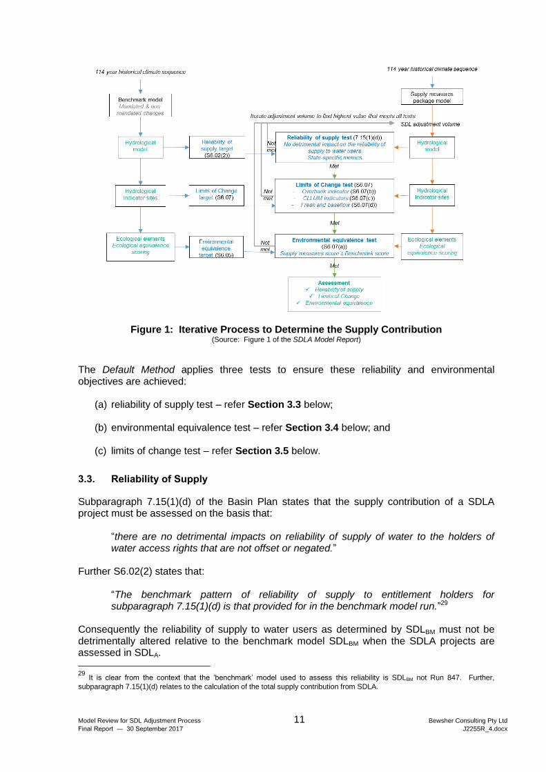
SDLBM. Initially the environmental outcomes and the reliability of supplies are calculated from SDLBM. Then all the supply measures are packaged together and added to SDLBM. An iterative process then commences to determine the maximum achievable supply contribution, whilst ensuring there are no detrimental impacts on reliability and ensuring that equivalent environmental outcomes are achieved. This process is shown in Figure 1 which has been extracted from the SDLA Model Report.
28
i.e. the holders of water access rights which are “not offset or negated” (i.e. do not cease to be used as a result of the water
recovery processes under the Basin Plan). Further this determination is of the impacts that the supply measures will have when they come into operation.
Model Review for SDL Adjustment Process 11 Bewsher Consulting Pty Ltd
Final Report ― 30 September 2017 J2255R_4.docx
Figure 1: Iterative Process to Determine the Supply Contribution (Source: Figure 1 of the SDLA Model Report)
The Default Method applies three tests to ensure these reliability and environmental objectives are achieved:
(a) reliability of supply test – refer Section 3.3 below;
(b) environmental equivalence test – refer Section 3.4 below; and
(c) limits of change test – refer Section 3.5 below.
3.3. Reliability of Supply
Subparagraph 7.15(1)(d) of the Basin Plan states that the supply contribution of a SDLA project must be assessed on the basis that:
“there are no detrimental impacts on reliability of supply of water to the holders of water access rights that are not offset or negated.”
Further S6.02(2) states that: “The benchmark pattern of reliability of supply to entitlement holders for
subparagraph 7.15(1)(d) is that provided for in the benchmark model run.”29 Consequently the reliability of supply to water users as determined by SDLBM must not be detrimentally altered relative to the benchmark model SDLBM when the SDLA projects are assessed in SDLA.
29
It is clear from the context that the ‘benchmark’ model used to assess this reliability is SDLBM not Run 847. Further,
subparagraph 7.15(1)(d) relates to the calculation of the total supply contribution from SDLA.
Model Review for SDL Adjustment Process 12 Bewsher Consulting Pty Ltd
Final Report ― 30 September 2017 J2255R_4.docx
The term ‘reliability’ is not specifically defined in either the Basin Plan or the Water Act 2007 (Cth). Within common usage the term means “the quality or state of being reliable”30 and the extent to which water supplies continue to be provided “in the way you expect”.31 As water supplies and water allocations vary temporally, spatially and volumetrically in a complex manner due to variations in climate and water availability, it is not surprising that a wide range of metrics for water ‘reliability’ are traditionally used across the Basin. Further S6.02(2) requires that the pattern of the reliability must not be detrimentally impacted so this necessitates consideration of a range of metrics. The existing metrics that are most commonly used by water agencies in the Basin relate to the announced allocations (e.g. the frequency of full allocations in a particular month of the year) and are usually reflected within the individual water sharing plans or bulk entitlements developed for each valley. In the opinion of the reviewer, in view of the existing practice for quantifying reliability and the requirements of the Basin Plan, there is no unique metric which can be used for the ‘reliability test’ when calculating the supply contribution of the SDLA. Consequently this makes compliance with subparagraph 7.15(1)(d) of the Basin Plan difficult. As a result the assessments of reliability undertaken to date for the SDLA projects have utilised both a suite of reliability metrics and an expert review of model results by State water managers.32
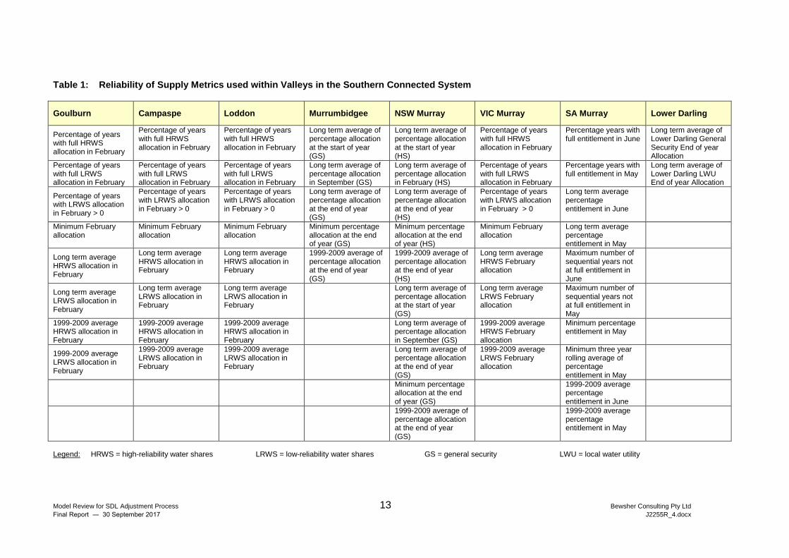
The metrics which are used in the SDLA Model Report are summarised in Table 1.
The reviewer considers the metrics in Table 1 are suitably broad and likely to be sufficient for assessment of the requirements of subparagraph 7.15(1)(d) and S6.02(2) of the Basin Plan. As discussed at the end of Section 4.1, when the SDLA projects are designed and implemented, there may be refinements to the present understanding of the projects and the manner in which they have been represented in SDLA. Nevertheless the reviewer understands that BOC recognises the reliability constraints on the implemented projects and has stated that
“If the operation of the SDL adjustment mechanism has the potential to result in reduction of reliability for entitlement holders, jurisdictions will work together to find real world solutions to address those reliability concerns, consistent with the requirements of the Basin Plan”.33
3.4. Environmental Outcomes Scoring
A key component of the development of the SDLA mechanism in the southern connected system has been the preparation of a system to score environmental outcomes of different flow regimes. The principles underpinning the development of this scoring system are described in Schedule 6 of the Basin Plan. This scoring system was a consideration in the development of the Environmentally Sustainable Level of Take (ESLT) method.34
30
https://www.merriam-webster.com/dictionary/reliability 31
http://dictionary.cambridge.org/dictionary/english/reliable 32
For the suite of reliability metrics being used previously to assess impacts on Victoria’s, New South Wales’ and South
Australia’s water users refer Tables 47, 48 and 49, respectively, of the ‘Trial Application’ report listed in item B12 of Appendix B. 33
Refer page 19 of document B22 in Appendix B. 34
Refer MDBA 2011 publication in item B3 of Appendix B. This report outlines the methods and modelled outcomes of the
ESLT process.
Model Review for SDL Adjustment Process 13 Bewsher Consulting Pty Ltd
Final Report ― 30 September 2017 J2255R_4.docx
Table 1: Reliability of Supply Metrics used within Valleys in the Southern Connected System
Goulburn Campaspe Loddon Murrumbidgee NSW Murray VIC Murray SA Murray Lower Darling
Percentage of years with full HRWS allocation in February
Percentage of years with full HRWS allocation in February
Percentage of years with full HRWS allocation in February
Long term average of percentage allocation at the start of year (GS)
Long term average of percentage allocation at the start of year (HS)
Percentage of years with full HRWS allocation in February
Percentage years with full entitlement in June
Long term average of Lower Darling General Security End of year Allocation
Percentage of years with full LRWS allocation in February
Percentage of years with full LRWS allocation in February
Percentage of years with full LRWS allocation in February
Long term average of percentage allocation in September (GS)
Long term average of percentage allocation in February (HS)
Percentage of years with full LRWS allocation in February
Percentage years with full entitlement in May
Long term average of Lower Darling LWU End of year Allocation
Percentage of years with LRWS allocation in February > 0
Percentage of years with LRWS allocation in February > 0
Percentage of years with LRWS allocation in February > 0
Long term average of percentage allocation at the end of year (GS)
Long term average of percentage allocation at the end of year (HS)
Percentage of years with LRWS allocation in February > 0
Long term average percentage entitlement in June
Minimum February allocation
Minimum February allocation
Minimum February allocation
Minimum percentage allocation at the end of year (GS)
Minimum percentage allocation at the end of year (HS)
Minimum February allocation
Long term average percentage entitlement in May
Long term average HRWS allocation in February
Long term average HRWS allocation in February
Long term average HRWS allocation in February
1999-2009 average of percentage allocation at the end of year (GS)
1999-2009 average of percentage allocation at the end of year (HS)
Long term average HRWS February allocation
Maximum number of sequential years not at full entitlement in June
Long term average LRWS allocation in February
Long term average LRWS allocation in February
Long term average LRWS allocation in February
Long term average of percentage allocation at the start of year (GS)
Long term average LRWS February allocation
Maximum number of sequential years not at full entitlement in May
1999-2009 average HRWS allocation in February
1999-2009 average HRWS allocation in February
1999-2009 average HRWS allocation in February
Long term average of percentage allocation in September (GS)
1999-2009 average HRWS February allocation
Minimum percentage entitlement in May
1999-2009 average LRWS allocation in February
1999-2009 average LRWS allocation in February
1999-2009 average LRWS allocation in February
Long term average of percentage allocation at the end of year (GS)
1999-2009 average LRWS February allocation
Minimum three year rolling average of percentage entitlement in May
Minimum percentage allocation at the end of year (GS)
1999-2009 average percentage entitlement in June
1999-2009 average of percentage allocation at the end of year (GS)
1999-2009 average percentage entitlement in May
Legend: HRWS = high-reliability water shares LRWS = low-reliability water shares GS = general security LWU = local water utility
Model Review for SDL Adjustment Process 14 Bewsher Consulting Pty Ltd
Final Report ― 30 September 2017 J2255R_4.docx
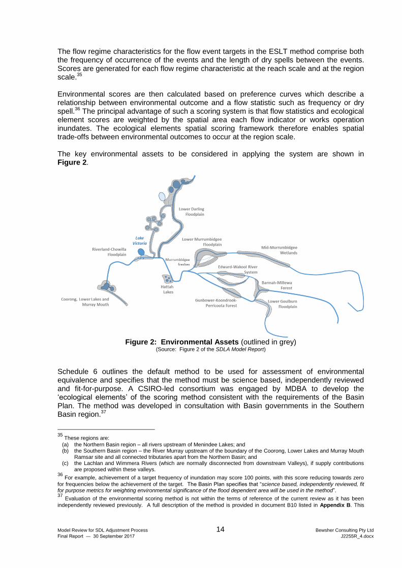
The flow regime characteristics for the flow event targets in the ESLT method comprise both the frequency of occurrence of the events and the length of dry spells between the events. Scores are generated for each flow regime characteristic at the reach scale and at the region scale.35 Environmental scores are then calculated based on preference curves which describe a relationship between environmental outcome and a flow statistic such as frequency or dry spell.36 The principal advantage of such a scoring system is that flow statistics and ecological element scores are weighted by the spatial area each flow indicator or works operation inundates. The ecological elements spatial scoring framework therefore enables spatial trade-offs between environmental outcomes to occur at the region scale. The key environmental assets to be considered in applying the system are shown in Figure 2.
Figure 2: Environmental Assets (outlined in grey)
(Source: Figure 2 of the SDLA Model Report)
Schedule 6 outlines the default method to be used for assessment of environmental equivalence and specifies that the method must be science based, independently reviewed and fit-for-purpose. A CSIRO-led consortium was engaged by MDBA to develop the ‘ecological elements’ of the scoring method consistent with the requirements of the Basin Plan. The method was developed in consultation with Basin governments in the Southern Basin region.37
35
These regions are:
(a) the Northern Basin region – all rivers upstream of Menindee Lakes; and (b) the Southern Basin region – the River Murray upstream of the boundary of the Coorong, Lower Lakes and Murray Mouth
Ramsar site and all connected tributaries apart from the Northern Basin; and (c) the Lachlan and Wimmera Rivers (which are normally disconnected from downstream Valleys), if supply contributions
are proposed within these valleys. 36
For example, achievement of a target frequency of inundation may score 100 points, with this score reducing towards zero
for frequencies below the achievement of the target. The Basin Plan specifies that “science based, independently reviewed, fit for purpose metrics for weighting environmental significance of the flood dependent area will be used in the method”. 37
Evaluation of the environmental scoring method is not within the terms of reference of the current review as it has been
independently reviewed previously. A full description of the method is provided in document B10 listed in Appendix B. This
Model Review for SDL Adjustment Process 15 Bewsher Consulting Pty Ltd
Final Report ― 30 September 2017 J2255R_4.docx
When considering SDLAs, its region score must be better than, or equivalent to the benchmark model score.
Further the MDBA has identified that the assumed ecological health at the beginning of the simulation in 1895 can lead to different overall scores. Accordingly within the SDLA Model Report three alternative starting conditions are used to address this potential uncertainty of initial ecological conditions. The environmental equivalence test is applicable for all three cases. The method requires that there is no reduction in the overall environmental outcome scores. However, it does allow some reductions in individual elements and/or reaches if they are offset by increases in other elements and/or reaches.
3.5. Limits of Change
It is important to understand that in applying the Default Method to determine the supply contribution for the SDLA, the Basin Plan specifies limits on the changes in environmental scores or outcomes that can occur. These limits effectively constrain the extent of the SDLA supply contribution that can occur. These limits are for the purpose of modelling SDLA and do not necessarily represent environmental watering or management targets.
These limits of change are set out in S6.07 of Schedule 6 and include:
(a) no reduction in the benchmark environmental outcome scores of the region;38
(b) all achievements of a target frequency range in a reach within the benchmark run must be preserved and the frequency result must not vary by more than 10% of the benchmark result;39
(c) in any reach where the benchmark run does not achieve the target frequency range for a specific flow indicator, the frequency result must not vary by more than 10% of the benchmark result, and not fall below the baseline model result;39
(d) in any reach where the benchmark model run provides little improvement in frequency for a flow indicator (less than 50% progress toward the target range from the baseline model result), the frequency result must not vary by more than 15% of the benchmark result, and not fall below the baseline model result; 39
(e) for the Coorong, Lower Lakes, Murray Mouth – maintenance or improvement of a range of flow and salinity targets, and targets relating to the periods when the mouth is open;
document includes the results of some initial testing undertaken by CSIRO using model data for reaches at the Riverland-Chowilla Floodplain (South Australia) (River Murray Lower reach) and Gunbower-Koondrook-Perricoota Forest (River Murray Upper Central reach) (Victoria and New South Wales). The reviewer understands a subsequent and more comprehensive review of the method, including its performance during the trial and subsequent revisions to the initial method, are documented in the ‘SDL Adjustment Ecological Elements Method Trial Implementation Review’ (Overton et al, 2015). 38
Although some reductions in individual elements within the region may be permitted if they are offset by increases in other
elements so that the region score is not reduced. 39
Where a flow indicator exceeds these limits of change, but other indicators at the site are within the limits of change,
modelling under the default method will redistribute the use of environmental water amongst flow indicators to balance outcomes with respect to (b), (c) and (d). Consistent with section S6.06(3) of Schedule 6, redistribution of environmental water will occur to the minimum extent necessary to ensure that the limits of change are met and not to otherwise affect environmental flow outcomes in the benchmark model. In addition, where a supply measure or combination of measures can achieve the ecological outcomes represented by an ecological target or targets, and a flow indicator or indicators and associated benchmark model results, then the requirements of (b), (c) and (d) do not apply.
Model Review for SDL Adjustment Process 16 Bewsher Consulting Pty Ltd
Final Report ― 30 September 2017 J2255R_4.docx
(f) for all base flows and fresh requirements within each reach – no reduction in outcomes achieved in the benchmark run.
3.6. Application within the Modelling Framework
Because of the requirements described in Sections 3.2 to 3.5, the process of determining an SDLA volume requires numerous iterations within the modelling framework. Figure 1 illustrates this iterative process and demonstrates how an initial estimate of the SDLA supply contribution requires adjustment in order to satisfy the limits of change whilst also complying with both the environmental score and the reliability constraints. Based on the interviews that have been conducted with the MDBA staff and review of the SDLA Model Report the reviewer has not identified any inconsistencies of approach with the Basin Plan when calculating the SDLA supply contribution.
4. ASSESSMENT OF SDLA MODELLING
4.1. Representation of SDLA Projects in SDLA
This section examines how the SDLA projects have been included in SDLA. The 36 SDLA projects which are under consideration by the MDBA and have been described in the SDLA Model Report, are listed in Appendix C. Because all hydrological models are only approximations of actual or proposed behaviour, the modelled representations of the individual SDLA projects are also approximations. However through the inclusion of more detailed information it is always possible to improve a model’s simulation. As a result the modeller has to make a subjective assessment of the level of detail to include noting that typically the ‘law of diminishing returns’ applies i.e. increasingly greater effort is required to improve simulation accuracy. Consequently the level of detail to which SDLA projects have been included in SDLA has been an important consideration in this review. In the vast majority of projects that include physical works, these projects have not yet been designed or constructed. This means that there is also uncertainty concerning the final characteristics of the projects that will be implemented as it would be expected that changes will occur as a result of both detailed design and construction of the projects (once approved). There is a wide variety of projects and the reviewer expects there will be changes to the projects prior to implementation. Generally a simplified conceptualisation of each project has been prepared for inclusion in SDLA. For the reasons listed above including the uncertainties in the implemented projects, the reviewer considers the simplified conceptualisation of projects included in SDLA to be appropriate.40
40
The reviewer also notes that in relation to environmental works to enhance watering of floodplains, generally proponents
have carried out more detailed hydrodynamic modelling as part of the preparation of their business cases and have used these more detailed models to inform the simpler conceptualisation of the project that is included in SDLA (and documented in the Notification Imperfection Register or NIR).
Model Review for SDL Adjustment Process 17 Bewsher Consulting Pty Ltd
Final Report ― 30 September 2017 J2255R_4.docx
4.2. Endorsement of Projects by BOC
All 36 SDLA projects have all been endorsed by BOC and the Authority. The reviewer understands that all of the projects have undergone the three phase submission process through SDLAAC41 involving a ‘Feasibility Study’, ‘Assessment of Business Case’ and subsequent ‘Confirmation’.42 In relation to the preparation of the modelling components for inclusion of an individual SDLA project in SDLA the reviewer understands that the following process has been adopted:
(a) initial proposal submission by proponent;
(b) consideration by MDBA and identification of further information required to model the project;
(c) preparation of modelling information required by the MDBA and the proponent;
(d) documentation of the information in the Notification Imperfection Register (NIR);43
(e) formal notification of amendments to the project; and
(f) endorsement by BOC. Consequently prior to endorsement by BOC all the SDLA projects have gone through the above processes and all relevant modelling information (including the NIR) have been reviewed by SDLAAC and its Technical Working Group (SDLAACTWG). This process provides additional confidence that the conceptualisation of the projects included within SDLA is appropriate.
4.3. Reconciliation of Adjustments in 2024
There is provision under subparagraph 7.11 of the Basin Plan for the SDLA amount to be amended in 2024 if the Authority determines this is necessary. If this is the case then the Authority must calculate the new SDLA amount and prepare appropriate amendments of the Basin Plan for adoption by the Minister. If this occurs it is likely the Authority will propose adjustments in sufficient time for the amendments to commence by 30 June 2024. By this stage all the projects will have been designed and implemented and there will be experience gained in actual operations. This will also allow the conceptualisation of the proposals which are currently provided in SDLA to be improved. Given the nature of many of the proposals and the current stage of their development, the reviewer would expect some differences when the implemented projects are reconciled with the current SDLA. The 2024 reconciliation will provide an opportunity for both increases and decreases in the
41
SDLAAC = SDL Adjustment Advisory Committee 42
Schedule 1 of the draft Intergovernmental Agreement (IGA) sets out the framework for an intergovernmental process to
implement the SDL adjustment mechanism. The framework includes a three phased process for jurisdictions to follow in developing proposals for addressing constraints and adjusting SDLs. The IGA Schedule also provides for the establishment of an intergovernmental committee (i.e. SDLAAC) to oversee the process for developing and evaluating proposals for inclusion in the package of agreed measures. 43
A copy of the NIR was provided to the reviewer (refer item B20 in Appendix B).
Model Review for SDL Adjustment Process 18 Bewsher Consulting Pty Ltd
Final Report ― 30 September 2017 J2255R_4.docx
SDLA amounts to occur in line with this experience, and for an improved conceptualisation of SDLA projects to be included within SDLA, if the Authority determines this is necessary.
4.4. Preservation of the SDLBM and SDLA Models
Given the critical importance of the SDLBM and SDLA models to the SDLA process, it is recommended that all model data files and all components of the modelling framework be ‘frozen’ and preserved so that the models can be revisited in the future as the need arises.
4.5. Response to Terms of Reference
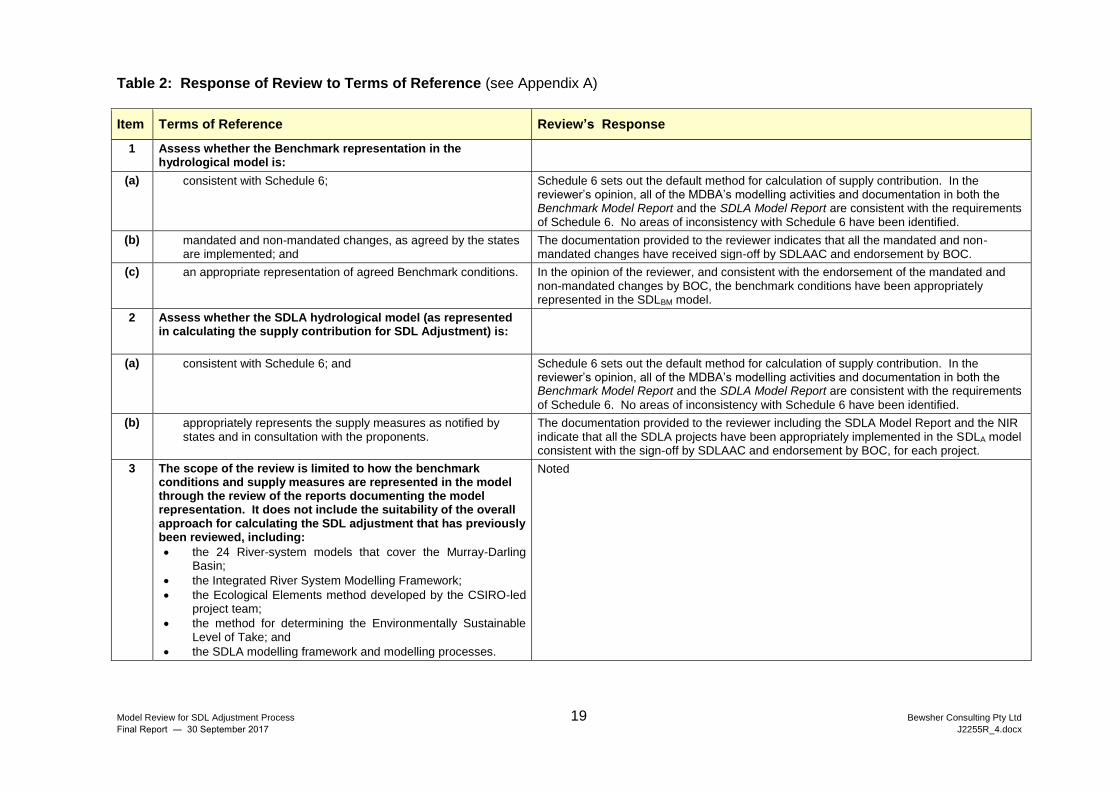
The review’s responses to the items listed under the ‘Scope of Work’ section of the Terms of Reference are provided in Table 2.
Model Review for SDL Adjustment Process 19 Bewsher Consulting Pty Ltd
Final Report ― 30 September 2017 J2255R_4.docx
Table 2: Response of Review to Terms of Reference (see Appendix A)
Item Terms of Reference Review’s Response
1 Assess whether the Benchmark representation in the hydrological model is:
(a) consistent with Schedule 6;
Schedule 6 sets out the default method for calculation of supply contribution. In the reviewer’s opinion, all of the MDBA’s modelling activities and documentation in both the Benchmark Model Report and the SDLA Model Report are consistent with the requirements of Schedule 6. No areas of inconsistency with Schedule 6 have been identified.
(b) mandated and non-mandated changes, as agreed by the states are implemented; and
The documentation provided to the reviewer indicates that all the mandated and non-mandated changes have received sign-off by SDLAAC and endorsement by BOC.
(c) an appropriate representation of agreed Benchmark conditions. In the opinion of the reviewer, and consistent with the endorsement of the mandated and non-mandated changes by BOC, the benchmark conditions have been appropriately represented in the SDLBM model.
2 Assess whether the SDLA hydrological model (as represented in calculating the supply contribution for SDL Adjustment) is:
(a) consistent with Schedule 6; and Schedule 6 sets out the default method for calculation of supply contribution. In the reviewer’s opinion, all of the MDBA’s modelling activities and documentation in both the Benchmark Model Report and the SDLA Model Report are consistent with the requirements
of Schedule 6. No areas of inconsistency with Schedule 6 have been identified.
(b) appropriately represents the supply measures as notified by states and in consultation with the proponents.
The documentation provided to the reviewer including the SDLA Model Report and the NIR indicate that all the SDLA projects have been appropriately implemented in the SDLA model consistent with the sign-off by SDLAAC and endorsement by BOC, for each project.
3 The scope of the review is limited to how the benchmark conditions and supply measures are represented in the model through the review of the reports documenting the model representation. It does not include the suitability of the overall approach for calculating the SDL adjustment that has previously been reviewed, including:
the 24 River-system models that cover the Murray-Darling Basin;
the Integrated River System Modelling Framework;
the Ecological Elements method developed by the CSIRO-led project team;
the method for determining the Environmentally Sustainable Level of Take; and
the SDLA modelling framework and modelling processes.
Noted
Model Review for SDL Adjustment Process 20 Bewsher Consulting Pty Ltd
Final Report ― 30 September 2017 J2255R_4.docx
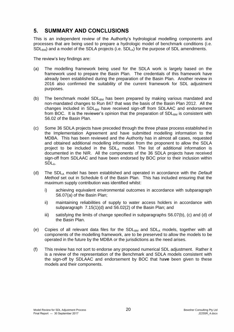
5. SUMMARY AND CONCLUSIONS
This is an independent review of the Authority’s hydrological modelling components and processes that are being used to prepare a hydrologic model of benchmark conditions (i.e. SDLBM) and a model of the SDLA projects (i.e. SDLA) for the purpose of SDL amendments. The review’s key findings are: (a) The modelling framework being used for the SDLA work is largely based on the
framework used to prepare the Basin Plan. The credentials of this framework have already been established during the preparation of the Basin Plan. Another review in 2016 also confirmed the suitability of the current framework for SDL adjustment purposes.
(b) The benchmark model SDLBM has been prepared by making various mandated and non-mandated changes to Run 847 that was the basis of the Basin Plan 2012. All the changes included in SDLBM have received sign-off from SDLAAC and endorsement from BOC. It is the reviewer’s opinion that the preparation of SDLBM is consistent with S6.02 of the Basin Plan.
(c) Some 36 SDLA projects have preceded through the three phase process established in the Implementation Agreement and have submitted modelling information to the MDBA. This has been reviewed and the Authority has in almost all cases, requested and obtained additional modelling information from the proponent to allow the SDLA project to be included in the SDLA model. The list of additional information is documented in the NIR. All the components of the 36 SDLA projects have received sign-off from SDLAAC and have been endorsed by BOC prior to their inclusion within SDLA.
(d) The SDLA model has been established and operated in accordance with the Default Method set out in Schedule 6 of the Basin Plan. This has included ensuring that the maximum supply contribution was identified whilst:
i) achieving equivalent environmental outcomes in accordance with subparagraph S6.07(a) of the Basin Plan;
ii) maintaining reliabilities of supply to water access holders in accordance with subparagraph 7.15(1)(d) and S6.02(2) of the Basin Plan; and
iii) satisfying the limits of change specified in subparagraphs S6.07(b), (c) and (d) of the Basin Plan.
(e) Copies of all relevant data files for the SDLBM and SDLA models, together with all components of the modelling framework, are to be preserved to allow the models to be operated in the future by the MDBA or the jurisdictions as the need arises.
(f) This review has not sort to endorse any proposed numerical SDL adjustment. Rather it is a review of the representation of the Benchmark and SDLA models consistent with the sign-off by SDLAAC and endorsement by BOC that have been given to these models and their components.
Model Review for SDL Adjustment Process A Bewsher Consulting Pty Ltd
Final Report ― 30 September 2017 J2255R_4.docx
APPENDIX A
TERMS OF REFERENCE FOR THIS REVIEW
Model Review for SDL Adjustment Process A1 Bewsher Consulting Pty Ltd
Final Report ― 30 September 2017 J2255R_4.docx
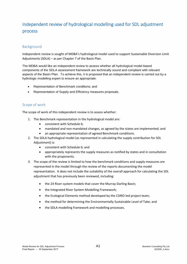
Independent review of hydrological modelling used for SDL adjustment
process
Background
Independent review is sought of MDBA’s hydrological model used to support Sustainable Diversion Limit
Adjustments (SDLA) – as per Chapter 7 of the Basin Plan.
The MDBA would like an independent review to assess whether all hydrological model-based
components of the SDLA assessment framework are technically sound and compliant with relevant
aspects of the Basin Plan. To achieve this, it is proposed that an independent review is carried out by a
hydrologic modelling expert to ensure an appropriate:
Representation of Benchmark conditions; and
Representation of Supply and Efficiency measures proposals.
Scope of work
The scope of work of this independent review is to assess whether:
1. The Benchmark representation in the hydrological model are:
consistent with Schedule 6;
mandated and non-mandated changes, as agreed by the states are implemented; and
an appropriate representation of agreed Benchmark conditions.
2. The SDLA hydrological model (as represented in calculating the supply contribution for SDL
Adjustment) is:
consistent with Schedule 6; and
appropriately represents the supply measures as notified by states and in consultation
with the proponents.
3. The scope of the review is limited to how the benchmark conditions and supply measures are
represented in the model through the review of the reports documenting the model
representation. It does not include the suitability of the overall approach for calculating the SDL
adjustment that has previously been reviewed, including:
the 24 River-system models that cover the Murray-Darling Basin;
the Integrated River System Modelling Framework;
the Ecological Elements method developed by the CSIRO-led project team;
the method for determining the Environmentally Sustainable Level of Take; and
the SDLA modelling framework and modelling processes.
Model Review for SDL Adjustment Process A2 Bewsher Consulting Pty Ltd
Final Report ― 30 September 2017 J2255R_4.docx
Approach and Methodology
The findings of the independent review should be submitted as a final report supported by following
activities:
1. Inception meeting (Teleconference).
Provide any clarification or further details on the scope of work;
Discuss evaluation criteria to be applied as part of the review; and
Discuss documents and other materials to be supplied by MDBA if needed for the review.
Agree on the content of the Final report.
2. Draft report summarising review findings.
Deliverables
A draft report need to be submitted to the MDBA one week prior to the final report for comment on the
review findings. The draft report should include:
Scope, methodology and criteria applied by the review;
An evaluation of the model representation of the benchmark condition and notified measures;
and
Suggested improvements to enhance the fit-for-purpose
The final report must address the comments received from MDBA by 15 September. It is likely that the
independent review will be made publicly available.
Model Review for SDL Adjustment Process B Bewsher Consulting Pty Ltd
Final Report ― 30 September 2017 J2255R_4.docx
APPENDIX B
PRINCIPAL DOCUMENTS EXAMINED DURING THIS REVIEW
Model Review for SDL Adjustment Process B1 Bewsher Consulting Pty Ltd
Final Report ― 30 September 2017 J2255R_4.docx
Review documents (in chronological order):
B1. Proposed River Modelling Methods and Integrated River System Modelling Framework Design for use in Basin Plan Modelling. Podger, G., Yang, A., Brown, A., Teng, J., Power, R. and Seaton, S. CSIRO: Water for a Healthy Country National Research Flagship. July 2010.
B2. River System Modelling for the Basin Plan Assessment of fitness for purpose. Podger, G.M., Barma, D., Neal, B., Austin, K. and Murrihy, E. CSIRO: Water for a Healthy Country National Research Flagship. December 2010.
B3. The proposed “environmentally sustainable level of take” for surface water of the Murray‐Darling Basin: Methods and outcomes. MDBA publication no: 226/11. November 2011.
B4. Science Review of the estimation of an environmentally sustainable level of take for the Murray–Darling Basin. Young WJ, Bond N, Brookes J, Gawne B and Jones GJ. November 2011.
B5. Hydrologic modelling to inform the proposed Basin Plan - methods and results. MDBA publication no: 17/12. February 2012.
B6. Water Act 2007 (Cth) and Basin Plan, November 2012.
B7. Explanatory Statement, Basin Plan, 2012.
B8. Murray-Darling Basin Plan 2012 - Implementation Agreement. 7 August 2013.
B9. Benchmark conditions of development for adjustment of SDLs. (Based on Benchmark model used for the trial implementation of the default method). MDBA Publication no. 25/13 – v2. Preliminary draft version 2. October 2014.
B10. Development of the Murray-Darling Basin Plan SDL Adjustment Ecological Elements Method. Overton IC, Pollino CA, Roberts J, Reid JRW, Bond NR, McGinness HM, Gawne B, Stratford DS, Merrin LE, Barma D, Cuddy SM, Nielsen DL, Smith T, Henderson BL, Baldwin DS, Chiu GS and Doody TM. Report prepared by CSIRO for the MDBA. 2014.
B11. Process for assessing and reporting reliability impacts relating to the SDL Adjustment mechanism. SDL Adjustment Technical Working Group. Agenda Item 4. 19 March 2015.
B12. Calculating the ‘supply contribution’ for SDL Adjustment: A trial application of the ‘default method’ – Revised technical report. MDBA. May 2015.
B13. The Ecological Elements Method for adjusting the Murray–Darling Basin Plan Sustainable Diversion Limit. Overview of method development and evaluation. Overton IC, Pollino CA, Grigg NJ, Roberts J, Reid JRW, Bond NR, Barma D, Freebairn A, Stratford D and Evans K. CSIRO. 27 July 2015.
B14. SDL Adjustment Stocktake Report. Warren Martin and Graeme Turner. August 2015.
B15. Interim advice on supply measures - November 2015. MDBA. November 2015.
B16. PDF file with filename ‘00. SDL Adjustment Notification - 5 May 2016’. A 4872 page document combining, for each SDLA project, various submissions and business case
Model Review for SDL Adjustment Process B2 Bewsher Consulting Pty Ltd
Final Report ― 30 September 2017 J2255R_4.docx
details that have been provided by the project proponents. This was provided to the reviewer by the MDBA in August 2017.
B17. Review of the Hydrological Modelling Frameworks used to inform Potential Basin Plan Amendments. Final Report – September 2016 (including November 2016 Addendum). Prepared by Bewsher Consulting Pty Ltd for MDBA.
B18. Hydrologic Modelling for the Northern Basin Review. MDBA Publication 35/16. November 2016.
B19. Register of non-mandated Benchmark changes and exposure status. Agenda item 3 – BOC 50. 22 June 2017.
B20. 32 files defining amendments to SDLA projects which comprise the Notification Imperfection Register (NIR). Provided to the reviewer by the MDBA in August 2017. Undated.
B21. Benchmark conditions of development for assessment of the SDL supply contribution. MDBA. September 2017.
B22. Modelling Assessment to Determine SDL Adjustment Volume. MDBA. September 2017.
B23. Key results for September Interim run. MDBA. Internal draft report. September 2017.
Model Review for SDL Adjustment Process C Bewsher Consulting Pty Ltd
Final Report ― 30 September 2017 J2255R_4.docx
APPENDIX C
SDLA PROJECTS
Model Review for SDL Adjustment Process C1 Bewsher Consulting Pty Ltd
Final Report ― 30 September 2017 J2255R_4.docx
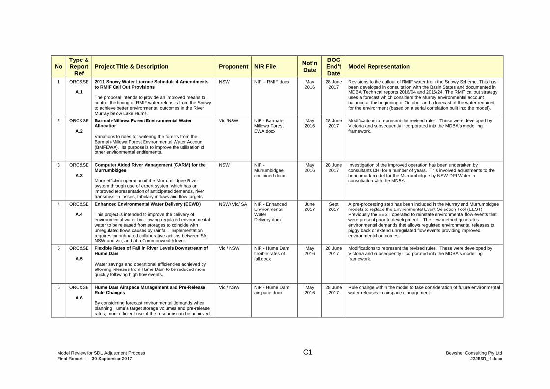
No Type & Report
Ref Project Title & Description Proponent NIR File
Not’n Date
BOC End’t Date
Model Representation
1 ORC&SE
A.1
2011 Snowy Water Licence Schedule 4 Amendments to RMIF Call Out Provisions The proposal intends to provide an improved means to control the timing of RMIF water releases from the Snowy to achieve better environmental outcomes in the River Murray below Lake Hume.
NSW NIR – RMIF.docx May 2016
28 June 2017
Revisions to the callout of RMIF water from the Snowy Scheme. This has been developed in consultation with the Basin States and documented in MDBA Technical reports 2016/04 and 2016/24. The RMIF callout strategy uses a forecast which considers the Murray environmental account balance at the beginning of October and a forecast of the water required for the environment (based on a serial correlation built into the model).
2 ORC&SE
A.2
Barmah-Millewa Forest Environmental Water Allocation Variations to rules for watering the forests from the Barmah-Millewa Forest Environmental Water Account (BMFEWA). Its purpose is to improve the utilisation of other environmental entitlements.
Vic /NSW NIR - Barmah-Millewa Forest EWA.docx
May 2016
28 June 2017
Modifications to represent the revised rules. These were developed by Victoria and subsequently incorporated into the MDBA’s modelling framework.
3 ORC&SE
A.3
Computer Aided River Management (CARM) for the Murrumbidgee More efficient operation of the Murrumbidgee River system through use of expert system which has an improved representation of anticipated demands, river transmission losses, tributary inflows and flow targets.
NSW NIR - Murrumbidgee combined.docx
May 2016
28 June 2017
Investigation of the improved operation has been undertaken by consultants DHI for a number of years. This involved adjustments to the benchmark model for the Murrumbidgee by NSW DPI Water in consultation with the MDBA.
4 ORC&SE
A.4
Enhanced Environmental Water Delivery (EEWD) This project is intended to improve the delivery of environmental water by allowing regulated environmental water to be released from storages to coincide with unregulated flows caused by rainfall. Implementation requires co-ordinated collaborative actions between SA, NSW and Vic, and at a Commonwealth level.
NSW/ Vic/ SA NIR - Enhanced Environmental Water Delivery.docx
June 2017
Sept 2017
A pre-processing step has been included in the Murray and Murrumbidgee models to replace the Environmental Event Selection Tool (EEST). Previously the EEST operated to reinstate environmental flow events that were present prior to development. The new method generates environmental demands that allows regulated environmental releases to piggy back or extend unregulated flow events providing improved environmental outcomes.
5 ORC&SE
A.5
Flexible Rates of Fall in River Levels Downstream of Hume Dam Water savings and operational efficiencies achieved by allowing releases from Hume Dam to be reduced more quickly following high flow events.
Vic / NSW NIR - Hume Dam flexible rates of fall.docx
May 2016
28 June 2017
Modifications to represent the revised rules. These were developed by Victoria and subsequently incorporated into the MDBA’s modelling framework.
6 ORC&SE
A.6
Hume Dam Airspace Management and Pre-Release Rule Changes By considering forecast environmental demands when planning Hume’s target storage volumes and pre-release rates, more efficient use of the resource can be achieved.
Vic / NSW NIR - Hume Dam airspace.docx
May 2016
28 June 2017
Rule change within the model to take consideration of future environmental water releases in airspace management.
Model Review for SDL Adjustment Process C2 Bewsher Consulting Pty Ltd
Final Report ― 30 September 2017 J2255R_4.docx
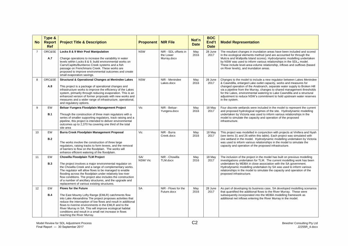
No Type & Report
Ref Project Title & Description Proponent NIR File
Not’n Date
BOC End’t Date
Model Representation
7 ORC&SE
A.7
Locks 8 & 9 Weir Pool Manipulation Change operations to increase the variability in water levels within Locks 8 & 9, build environmental works on Carrs/Capitts/Bunberoo Creek systems and a fish passage on Frenchmans Creek. These works are proposed to improve environmental outcomes and create small evaporation savings.
NSW NIR - SDL offsets in the Lower Murray.docx
May 2016
28 June 2017
The resultant changes in inundation areas have been included and scored in the ecological elements method (and are accounted for through the Mulcra and Wallpolla Island scores). Hydrodynamic modelling undertaken by NSW was used to inform various relationships in the SDLA model. These include level-area-volume relationship, inflows and outflows (based on River levels), and inundation areas.
8 ORC&SE
A.8
Structural & Operational Changes at Menindee Lakes This project is a package of operational changes and infrastructure works to improve the efficiency of the Lakes system, primarily through reducing evaporation. This is an enhanced version of former proposals with new works and measures and a wider range of infrastructure, operational, and regulatory options.
NSW NIR - Menindee Lakes.docx
May 2016
28 June 2017
Changes to the model to include a new regulator between Lakes Menindee & Cawndilla, enlarged Lake outlet capacity, works and measures for changed operation of the Anabranch, separate water supply to Broken Hill via a pipeline from the Murray, changes to shared management thresholds for the Lakes, environmental watering to Lake Cawndilla and a structural adjustment to reduce NSW’s commitment to hold upstream water reserves in the system.
9 EW
B.1
Belsar-Yungera Floodplain Management Project Through the construction of three main regulators with a series of smaller supporting regulators, track raising and a pipeline, this project is intended to deliver environmental outcomes up to 2,370 ha covering one third of the total site area
Vic NIR - Belsar-Yungera.docx
May 2016
18 May 2017
Four discrete wetlands were included in the model to represent the current and proposed hydrological regimes of the site. Hydrodynamic modelling undertaken by Victoria was used to inform various relationships in the model to simulate the capacity and operation of the proposed infrastructure.
10 EW
B.2
Burra Creek Floodplain Management Proposal The works involve the construction of three large regulators, raising tracks to form levees, and the removal of barriers to flow on the floodplain. The works will enhance efficient watering of the floodplain.
Vic NIR - Burra Creek.docx
May 2016
18 May 2017
This project was modelled in conjunction with projects at Vinifera and Nyah (see items 31 and 26 within this table). Each project was simulated with one wetland in the model. Hydrodynamic modelling undertaken by Victoria was used to inform various relationships in the model to simulate the capacity and operation of the proposed infrastructure.
11 EW
B.3
Chowilla Floodplain TLM Project The project involves a major environmental regulator on the Chowilla Creek and a range of complementary works. The regulator will allow flows to be managed to enable flooding across the floodplain under relatively low river flow conditions. The project also includes the construction of a number of ancillary structures, and the upgrade and replacement of various existing structures.
SA/ NSW/ Vic
NIR - Chowilla TLM.docx
May 2016
18 May 2017
The inclusion of the project in the model has built on previous modelling investigations undertaken for TLM. The current modelling work has been undertaken by MDBA in close association with the SA government. Hydrodynamic modelling undertaken by SA was used to inform various relationships in the model to simulate the capacity and operation of the proposed infrastructure.
12 EW
B.4
Flows for the Future The East Mounty Lofty Range (EMLR) catchments flow into Lake Alexandrina The project proposes activities that reduce the interception of low flows and result in additional flows to riverine environments in the EMLR and to the River Murray in SA. This will improve ecological habitat conditions and result in a small net increase in flows reaching the River Murray.
SA NIR - Flows for the Future.docx
May 2016
28 June 2017
As part of developing its business case, SA developed modelling scenarios that quantified the additional flows to the River Murray. These were subsequently incorporated into the MDBA modelling framework as additional net inflows entering the River Murray in the model.
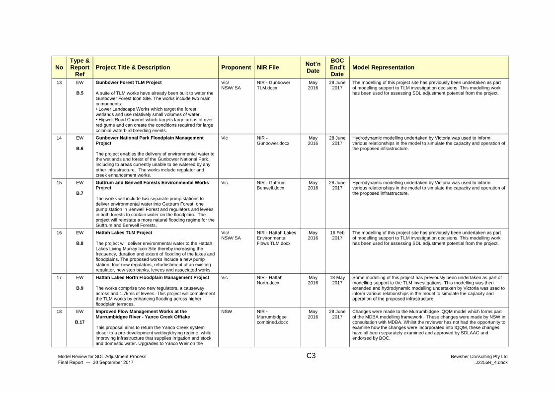
Model Review for SDL Adjustment Process C3 Bewsher Consulting Pty Ltd
Final Report ― 30 September 2017 J2255R_4.docx
No Type & Report
Ref Project Title & Description Proponent NIR File
Not’n Date
BOC End’t Date
Model Representation
13 EW
B.5
Gunbower Forest TLM Project A suite of TLM works have already been built to water the Gunbower Forest Icon Site. The works include two main components: • Lower Landscape Works which target the forest wetlands and use relatively small volumes of water. • Hipwell Road Channel which targets large areas of river red gums and can create the conditions required for large colonial waterbird breeding events.
Vic/ NSW/ SA
NIR - Gunbower TLM.docx
May 2016
28 June 2017
The modelling of this project site has previously been undertaken as part of modelling support to TLM investigation decisions. This modelling work has been used for assessing SDL adjustment potential from the project.
14 EW
B.6
Gunbower National Park Floodplain Management Project The project enables the delivery of environmental water to the wetlands and forest of the Gunbower National Park, including to areas currently unable to be watered by any other infrastructure. The works include regulator and creek enhancement works.
Vic NIR - Gunbower.docx
May 2016
28 June 2017
Hydrodynamic modelling undertaken by Victoria was used to inform various relationships in the model to simulate the capacity and operation of the proposed infrastructure.
15 EW
B.7
Guttrum and Benwell Forests Environmental Works Project The works will include two separate pump stations to deliver environmental water into Guttrum Forest, one pump station in Benwell Forest and regulators and levees in both forests to contain water on the floodplain. The project will reinstate a more natural flooding regime for the Guttrum and Benwell Forests.
Vic NIR - Guttrum Benwell.docx
May 2016
28 June 2017
Hydrodynamic modelling undertaken by Victoria was used to inform various relationships in the model to simulate the capacity and operation of the proposed infrastructure.
16 EW
B.8
Hattah Lakes TLM Project The project will deliver environmental water to the Hattah Lakes Living Murray Icon Site thereby increasing the frequency, duration and extent of flooding of the lakes and floodplains. The proposed works include a new pump station, four new regulators, refurbishment of an existing regulator, new stop banks, levees and associated works.
Vic/ NSW/ SA
NIR - Hattah Lakes Environmental Flows TLM.docx
May 2016
16 Feb 2017
The modelling of this project site has previously been undertaken as part of modelling support to TLM investigation decisions. This modelling work has been used for assessing SDL adjustment potential from the project.
17 EW
B.9
Hattah Lakes North Floodplain Management Project The works comprise two new regulators, a causeway across and 1.7kms of levees. This project will complement the TLM works by enhancing flooding across higher floodplain terraces.
Vic NIR - Hattah North.docx
May 2016
18 May 2017
Some modelling of this project has previously been undertaken as part of modelling support to the TLM investigations. This modelling was then extended and hydrodynamic modelling undertaken by Victoria was used to inform various relationships in the model to simulate the capacity and operation of the proposed infrastructure.
18 EW
B.17
Improved Flow Management Works at the Murrumbidgee River - Yanco Creek Offtake This proposal aims to return the Yanco Creek system closer to a pre-development wetting/drying regime, while improving infrastructure that supplies irrigation and stock and domestic water. Upgrades to Yanco Weir on the
NSW NIR - Murrumbidgee combined.docx
May 2016
28 June 2017
Changes were made to the Murrumbidgee IQQM model which forms part of the MDBA modelling framework. These changes were made by NSW in consultation with MDBA. Whilst the reviewer has not had the opportunity to examine how the changes were incorporated into IQQM, these changes have all been separately examined and approved by SDLAAC and endorsed by BOC.
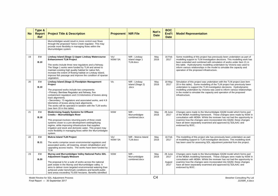
Model Review for SDL Adjustment Process C4 Bewsher Consulting Pty Ltd
Final Report ― 30 September 2017 J2255R_4.docx
No Type & Report
Ref Project Title & Description Proponent NIR File
Not’n Date
BOC End’t Date
Model Representation
Murrumbidgee would result in more control over flows through the proposed Yanco Creek regulator. This may provide more flexibility in managing flows within the Murrumbidgee system.
19 EW
B.10
Lindsay Island (Stage 1) Upper Lindsay Watercourse Enhancement TLM Project
The works include three new regulators and a fishway. The Stage 1 works were funded by TLM and aimed to maintain existing high quality habitat for native fish, increase the extent of flowing habitat on Lindsay Island, improve fish passage and improve the condition of riparian vegetation.
Vic/ NSW/ SA
NIR - Lindsay Island stage 1 TLM.docx
May 2016
16 Feb 2017
Some modelling of this project has previously been undertaken as part of modelling support to TLM investigation decisions. This modelling work has been extended and combined with simulation of works under Item 21 in this table. Hydrodynamic modelling undertaken by Victoria was used to inform various relationships in the model to simulate the capacity and operation of the proposed infrastructure.
20 EW
B.10
Lindsay Island (Stage 2) Floodplain Management Project The proposed works include two components: • Primary: Berribee Regulator and fishway, five containment regulators and 2.6 kilometres of levees along track alignments. • Secondary: 13 regulators and associated works, and 4.9 kilometres of levees along track alignments. The works will be operated in tandem with the TLM works (see Item 20 in this table).
Vic NIR - Lindsay Island (Stage 2) .docx
May 2016
18 May 2017
Simulation of this project was undertaken with the TLM project (see item 20 in this table). Some modelling of the TLM project has previously been undertaken to support the TLM investigation decisions. Hydrodynamic modelling undertaken by Victoria was used to inform various relationships in the model to simulate the capacity and operation of the proposed infrastructure.
21 EW
B.18
Modernising Supply Systems for Effluent Creeks – Murrumbidgee River This proposal involves returning parts of three creek systems closer to a pre-development wetting/drying regime, while improving infrastructure that supplies irrigation and stock and domestic water. This project may more flexibility in managing flows within the Murrumbidgee system.
NSW NIR - Murrumbidgee combined.docx
May 2016
28 June 2017
Changes were made to the Murrumbidgee IQQM model which forms part of the MDBA modelling framework. These changes were made by NSW in consultation with MDBA. Whilst the reviewer has not had the opportunity to examine how the changes were incorporated into IQQM, these changes have all been separately examined and approved by SDLAAC and endorsed by BOC.
22 EW
B.11
Mulcra Island TLM Project The works comprise seven environmental regulators and associated works, sill lowering, stream rehabilitation and upgrading access tracks. The works have been funded by TLM.
Vic/ NSW/ SA
NIR - Mulcra Island TLM.docx
May 2016
16 Feb 2017
The modelling of this project site has previously been undertaken as part of modelling support to TLM investigation decisions. This modelling work has been used for assessing SDL adjustment potential from the project.
23 EW
B.20
Murray and Murrumbidgee Valley National Parks SDL Adjustment Supply Measure
The proposal is for a suite of works across the national park estate in the Murray and Murrumbidgee valley. It aims to deliver more targeted environmental watering than achieved under benchmark conditions and benefit public land areas exceeding 70,000 hectares. Benefits identified
NSW NIR - Murrumbidgee combined.docx
May 2016
28 June 2017
August 2017
Changes were made to the Murrumbidgee IQQM model which forms part of the MDBA modelling framework. These changes were made by NSW in consultation with MDBA. Whilst the reviewer has not had the opportunity to examine how the changes were incorporated into IQQM, these changes have all been separately examined and approved by SDLAAC and endorsed by BOC.
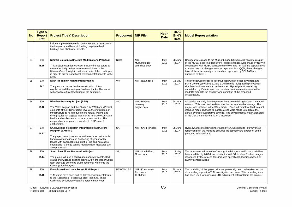
Model Review for SDL Adjustment Process C5 Bewsher Consulting Pty Ltd
Final Report ― 30 September 2017 J2255R_4.docx
No Type & Report
Ref Project Title & Description Proponent NIR File
Not’n Date
BOC End’t Date
Model Representation
include improved native fish outcomes and a reduction in the frequency and level of flooding on private land holdings and blackwater events.
24 EW
B.19
Nimmie Caira Infrastructure Modifications Proposal This project reconfigures water delivery infrastructure to more effectively deliver environmental flows to the Nimmie-Caira floodplain and other parts of the Lowbidgee in order to provide additional environmental benefits to the area.
NSW NIR - Murrumbidgee combined.docx
May 2016
28 June 2017
Changes were made to the Murrumbidgee IQQM model which forms part of the MDBA modelling framework. These changes were made by NSW in consultation with MDBA. Whilst the reviewer has not had the opportunity to examine how the changes were incorporated into IQQM, these changes have all been separately examined and approved by SDLAAC and endorsed by BOC.
25 EW
B.2
Nyah Floodplain Management Project The proposed works involve construction of four regulators and the raising of low level tracks. The works will enhance efficient watering of the floodplain.
Vic NIR - Nyah.docx May 2016
18 May 2017
This project was modelled in conjunction with projects at Vinifera and Burra Creeks (see items 31 and 11 within this table). Each project was simulated with one wetland in the model. Hydrodynamic modelling undertaken by Victoria was used to inform various relationships in the model to simulate the capacity and operation of the proposed infrastructure.
26 EW
B.12
Riverine Recovery Project (RRP) The Yatco Lagoon and the Phase 1 & 2 Wetlands Project elements of the RRP program involve the installation of infrastructure to re-introduce more natural wetting and drying cycles for targeted wetlands to improve ecosystem health and resilience and to reduce evaporation. The evaporation savings are converted to RRP class 9 entitlements.
SA NIR - Riverine recovery project.docx
May 2016
28 June 2017
SA carried out daily time-step water balance modelling for each managed wetland. This was used to determine the net evaporative savings. The project was included in the SDLA model. Each individual wetland was not included model changes to surface areas were made to replicate the annual average evaporative savings. The environmental water allocation of the Class 9 entitlement is also modelled.
27 EW
B.13
SA Riverland Floodplain Integrated Infrastructure Program (SARFIIP) The project comprises works and measures that enable floodplain inundation and freshening of groundwater lenses with particular focus on the Pike and Katarapko floodplains. Various salinity management measures are also proposed.
SA NIR - SARFIIP.docx May 2016
28 June 2017
Hydrodynamic modelling undertaken by SA was used to inform various relationships in the model to simulate the capacity and operation of the proposed infrastructure.
28 EW
B.14
South East Flows Restoration Project The project will use a combination of newly constructed drains and widened existing drains within the Upper South East drainage system to divert additional water into the Coorong South Lagoon.
SA NIR - South East Flows.docx
May 2016
18 May 2017
The timeseries inflow to the Coorong South Lagoon within the model has been modified by MDBA in consultation with SA to allow for the changes introduced by the project. This includes operational decisions based on salinity considerations.
29 EW
B.15
Koondrook-Perricoota Forest TLM Project TLM works have been built to deliver environmental water to the Koondrook-Perricoota Forest Icon Site. These works and associated operating regime have been
NSW/ Vic/ SA NIR - Koondrook-Perricoota TLM.docx
May 2016
28 June 2017
The modelling of this project site has previously been undertaken as part of modelling support to TLM investigation decisions. This modelling work has been used for assessing SDL adjustment potential from the project.
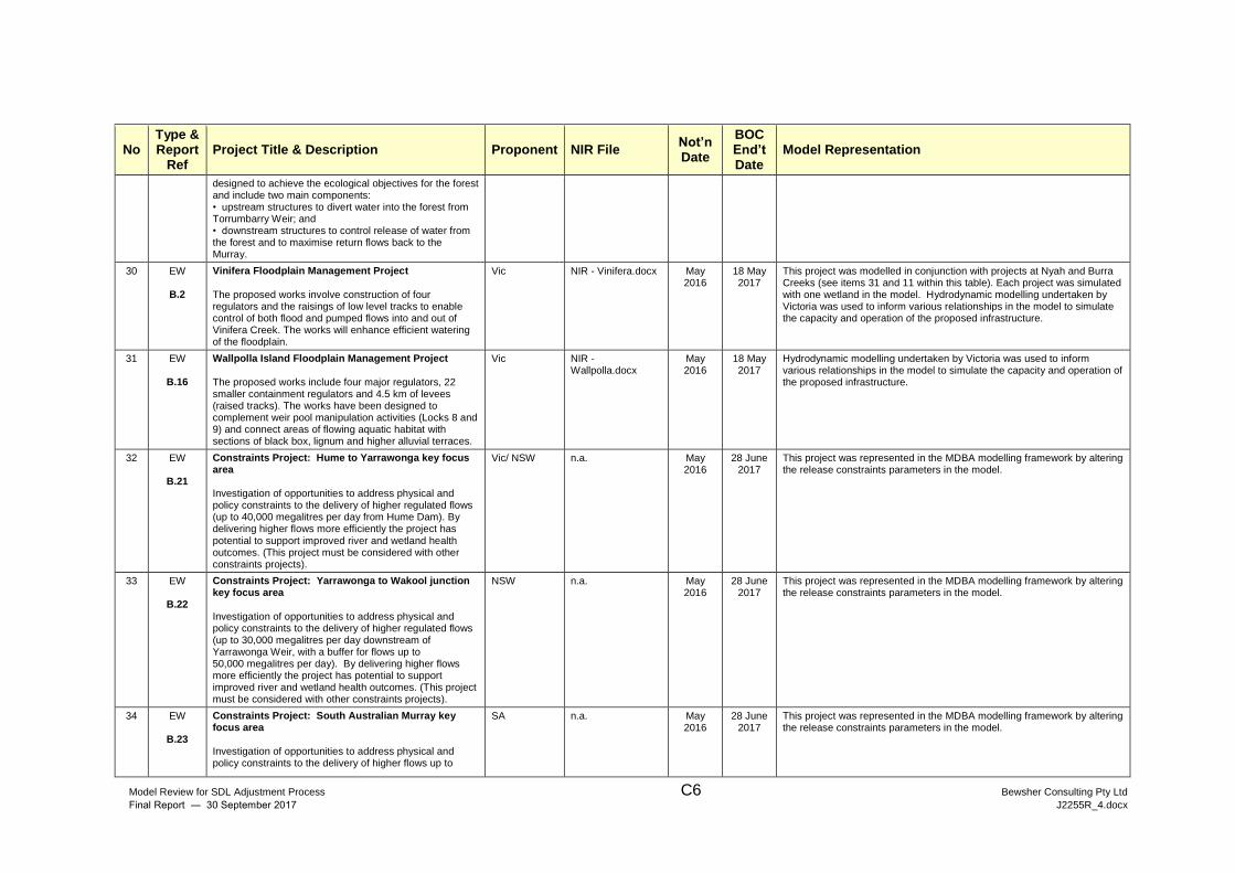
Model Review for SDL Adjustment Process C6 Bewsher Consulting Pty Ltd
Final Report ― 30 September 2017 J2255R_4.docx
No Type & Report
Ref Project Title & Description Proponent NIR File
Not’n Date
BOC End’t Date
Model Representation
designed to achieve the ecological objectives for the forest and include two main components: • upstream structures to divert water into the forest from Torrumbarry Weir; and • downstream structures to control release of water from the forest and to maximise return flows back to the Murray.
30 EW
B.2
Vinifera Floodplain Management Project
The proposed works involve construction of four regulators and the raisings of low level tracks to enable control of both flood and pumped flows into and out of Vinifera Creek. The works will enhance efficient watering of the floodplain.
Vic NIR - Vinifera.docx May 2016
18 May 2017
This project was modelled in conjunction with projects at Nyah and Burra Creeks (see items 31 and 11 within this table). Each project was simulated with one wetland in the model. Hydrodynamic modelling undertaken by Victoria was used to inform various relationships in the model to simulate the capacity and operation of the proposed infrastructure.
31 EW
B.16
Wallpolla Island Floodplain Management Project The proposed works include four major regulators, 22 smaller containment regulators and 4.5 km of levees (raised tracks). The works have been designed to complement weir pool manipulation activities (Locks 8 and 9) and connect areas of flowing aquatic habitat with sections of black box, lignum and higher alluvial terraces.
Vic NIR - Wallpolla.docx
May 2016
18 May 2017
Hydrodynamic modelling undertaken by Victoria was used to inform various relationships in the model to simulate the capacity and operation of the proposed infrastructure.
32 EW
B.21
Constraints Project: Hume to Yarrawonga key focus area Investigation of opportunities to address physical and policy constraints to the delivery of higher regulated flows (up to 40,000 megalitres per day from Hume Dam). By delivering higher flows more efficiently the project has potential to support improved river and wetland health outcomes. (This project must be considered with other constraints projects).
Vic/ NSW n.a. May 2016
28 June 2017
This project was represented in the MDBA modelling framework by altering the release constraints parameters in the model.
33 EW
B.22
Constraints Project: Yarrawonga to Wakool junction key focus area Investigation of opportunities to address physical and policy constraints to the delivery of higher regulated flows (up to 30,000 megalitres per day downstream of Yarrawonga Weir, with a buffer for flows up to 50,000 megalitres per day). By delivering higher flows more efficiently the project has potential to support improved river and wetland health outcomes. (This project must be considered with other constraints projects).
NSW n.a. May 2016
28 June 2017
This project was represented in the MDBA modelling framework by altering the release constraints parameters in the model.
34 EW
B.23
Constraints Project: South Australian Murray key focus area Investigation of opportunities to address physical and policy constraints to the delivery of higher flows up to
SA n.a. May 2016
28 June 2017
This project was represented in the MDBA modelling framework by altering the release constraints parameters in the model.
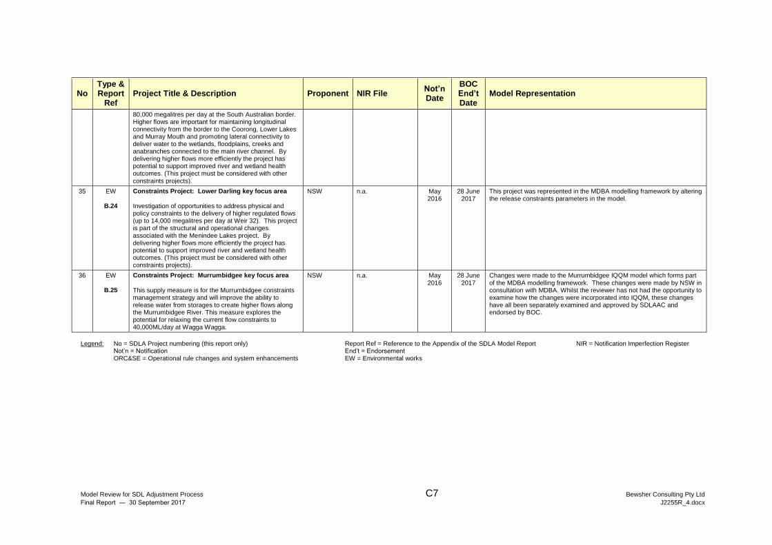
Model Review for SDL Adjustment Process C7 Bewsher Consulting Pty Ltd
Final Report ― 30 September 2017 J2255R_4.docx
No Type & Report
Ref Project Title & Description Proponent NIR File
Not’n Date
BOC End’t Date
Model Representation
80,000 megalitres per day at the South Australian border. Higher flows are important for maintaining longitudinal connectivity from the border to the Coorong, Lower Lakes and Murray Mouth and promoting lateral connectivity to deliver water to the wetlands, floodplains, creeks and anabranches connected to the main river channel. By delivering higher flows more efficiently the project has potential to support improved river and wetland health outcomes. (This project must be considered with other constraints projects).
35 EW
B.24
Constraints Project: Lower Darling key focus area Investigation of opportunities to address physical and policy constraints to the delivery of higher regulated flows (up to 14,000 megalitres per day at Weir 32). This project is part of the structural and operational changes associated with the Menindee Lakes project. By delivering higher flows more efficiently the project has potential to support improved river and wetland health outcomes. (This project must be considered with other constraints projects).
NSW n.a. May 2016
28 June 2017
This project was represented in the MDBA modelling framework by altering the release constraints parameters in the model.
36 EW
B.25
Constraints Project: Murrumbidgee key focus area
This supply measure is for the Murrumbidgee constraints management strategy and will improve the ability to release water from storages to create higher flows along the Murrumbidgee River. This measure explores the potential for relaxing the current flow constraints to 40,000ML/day at Wagga Wagga.
NSW n.a. May 2016
28 June 2017
Changes were made to the Murrumbidgee IQQM model which forms part of the MDBA modelling framework. These changes were made by NSW in consultation with MDBA. Whilst the reviewer has not had the opportunity to examine how the changes were incorporated into IQQM, these changes have all been separately examined and approved by SDLAAC and endorsed by BOC.
Legend: No = SDLA Project numbering (this report only) Report Ref = Reference to the Appendix of the SDLA Model Report NIR = Notification Imperfection Register
Not’n = Notification End’t = Endorsement ORC&SE = Operational rule changes and system enhancements EW = Environmental works


![Introduction to SDL Bibliography: [Doldi2001] L. Doldi, (2001), SDL Illustrated. [Edwards2001] S. Edwards, (2001), SDL, sedwards/classes/2001/w4995-](https://img.pdfslide.us/doc/110x75/56649efe5503460f94c121a9/introduction-to-sdl-bibliography-doldi2001-l-doldi-2001-sdl-illustrated.jpg)