Embed Size (px)
Citation preview

FOOD-PRODUCING LANDSCAPE DESIGN SAFETY CONSIDERATIONS IN THE PERI-URBAN DEVELOPMENT
OF EAST VILLAGE MONROE
MARIO CHRISTOPHER CAMBARDELLA
(Under the Direction of Judith Wasserman)
ABSTRACT
Food-producing landscapes are appearing in the urban and peri-urban environments because of
concerns about food security, lack of social capital in some urban settings, prospect of economic gain,
and concerns for public health. As food is recognized once again as an integral agent for more
sustainable cities, the landscape architecture profession has emerged capable of leading in the design of
an integrated and safe food-producing landscape in the built environment. To assist landscape
architects, this thesis posits a design matrix of safety considerations for designers of food-producing
landscapes in the peri-urban setting. Developed from an investigation of food-producing landscape
typologies, review of literature on the history of food-producing landscapes, and an inventory of existing
safety guidelines for landscape architects, the matrix offers a guide for food-producing landscape
designers to protect the public from physical harm, and clients and landscape architects from legal
liability. A design experiment of how a matrix may be utilized in analyzing safety in food-producing
landscape design is demonstrated through an integrated food-producing landscape at a mixed-use
development—East Village Monroe, in Monroe, Georgia.
INDEX WORDS: Food-producing landscapes, Public safety, Urban agriculture, Design liability, Design
Structure Matrix

FOOD-PRODUCING LANDSCAPE DESIGN SAFETY CONSIDERATIONS IN THE PERI-URBAN DEVELOPMENT
OF EAST VILLAGE MONROE
by
MARIO CHRISTOPHER CAMBARDELLA
BLA, University of Georgia, 2006
MEPD, University of Georgia, 2011
A Thesis Submitted to the Graduate Faculty of the University of Georgia in Partial Fulfillment of the
Requirements for the Degree
MASTER OF LANDSCAPE ARCHITECTURE
ATHENS, GEORGIA
2013

© 2013
Mario Christopher Cambardella
All Rights Reserved
FOOD-PRODUCING LANDSCAPE DESIGN SAFETY CONSIDERATIONS IN THE PERI-URBAN DEVELOPMENT
OF EAST VILLAGE MONROE
by
MARIO CHRISTOPHER CAMBARDELLA
Major Professor: Judith Wasserman
Committee: Sungkyung Lee David Berle Ben Liverman Electronic Version Approved: Maureen Grasso Dean of the Graduate School The University of Georgia May 2013

iv
DEDICATION
For my wife, my parents, and the CED.

v
ACKNOWLEDGEMENTS
If it takes a village to raise a child, it takes an entire college to educate a graduate student. I
acknowledge with gratitude those who taught, tested, and encouraged me on the journey through the
College of Environment and Design at the University of Georgia. Many thanks to the CED staff for all the
IT support and friendship. To the professors at the CED, thank you for sharing your guidance, expertise,
and passion for the environment and design. Thank you to Melissa Tufts, the CED librarian. Mrs. Tufts is
a testament as to why librarians are such an invaluable asset to students and our UGA community. To
Dr. John (Jack) Crowley, I am indebted to you, but shall submit repayment by sharing with all the
wisdom (and wit) you bestowed upon me to the next generation of MLAs and MEPDs.
I would like to thank committee members, Professor David Berle, and Ben Liverman, and
committee chair Professor Sungkyung Lee who graciously spent their time and talents assisting in the
completion of this thesis. I would like to extend a special thank you to Judith Wasserman, who served as
major professor and has been instrumental in my education as a student of the environment and design.
I could not have come this far without her unwavering support.
To my family, whose love and support is constant, thank you all.
And to my dear wife, Lindsey, I acknowledge I am forever in debt to you and happy to spend a
lifetime attempting to repay.
vi
TABLE OF CONTENTS
Page
ACKNOWLEDGEMENTS ................................................................................................................................. v
LIST OF TABLES ............................................................................................................................................ix
LIST OF FIGURES ............................................................................................................................................ x
CHAPTERS
INTRODUCTION: OPPORTUNITY AND CONSTRAINT AT EAST VILLAGE MONROE ..................... 1
I. METHODOLOGY: PUBLIC SAFETY IN FOOD-PRODUCING LANDSCAPE DESIGN ......................... 4
DESIGN STRUCTURE MATRIX .............................................................................................. 6
DELIMITATIONS ................................................................................................................... 9
DEFINITIONS ........................................................................................................................ 9
II. CLASSIFICATION OF CONTEMPORARY FOOD-PRODUCING LANDSCAPES .............................. 12
PEDESTRIAN-ORIENTED .................................................................................................... 13
URBANISM-ORIENTED ...................................................................................................... 14
PERFORMANCE-ORIENTED ............................................................................................... 16
CLASSIFICATION SUMMARY .............................................................................................. 18
vii
III. U.S. HISTORY OF FOOD-PRODUCING LANDSCAPES IN URBAN AND PERI-URBAN
ENVIRONMENT ........................................................................................................................ 19
GARDEN CITY MOVEMENT ............................................................................................... 21
SCHREBERGARTEN ............................................................................................................ 24
ST. ANNS ALLOTMENTS..................................................................................................... 25
VICTORY GARDENS ............................................................................................................ 26
BACK TO THE GARDEN MOVEMENT ................................................................................. 26
VILLAGE HOMES ................................................................................................................ 28
FOOD FOREST.................................................................................................................... 31
SUMMARY ......................................................................................................................... 32
IV. SAFETY CONSIDERATIONS IN FOOD-PRODUCTION LANDSCAPE DESIGN ............................... 34
INVENTORY ....................................................................................................................... 35
SOIL ................................................................................................................................... 35
WATER .............................................................................................................................. 37
FLORA & FAUNA ................................................................................................................ 37
SITE PLAN & PROGRAM .................................................................................................... 38
LIVESTOCK ......................................................................................................................... 39
BUFFERS ............................................................................................................................ 40

viii
OPERATIONS ..................................................................................................................... 41
SIGNAGE ............................................................................................................................ 41
ATTRACTIVE NUISANCE ..................................................................................................... 42
V. MATRIX IMPLEMENTATION: EAST VILLAGE MONROE ............................................................ 44
CULTURAL INVENTORY ..................................................................................................... 46
PHYSICAL INVENTORY ....................................................................................................... 49
BIOLOGICAL INVENTORY ................................................................................................... 56
CIRCULATION .................................................................................................................... 57
COMMUNITY DEVELOPMENT PROGRAM ......................................................................... 58
FOOD-PRODUCING LANDSCAPE PROGRAM ..................................................................... 59
MATRIX OF SAFETY CONSIDERATIONS FOR EAST VILLAGE MONORE .............................. 60
VI. CONCLUSION ........................................................................................................................... 65
VII. APPENDIX ............................................................................................................................... 67
VII. REFERENCES ........................................................................................................................... 69

ix
LIST OF TABLES
PAGE
TABLE 2.1: EDWARD ROBBINS PORTER "URBAN & AGRICULTURAL PROGRAMS BY UNIT AND SCALE” .. 14
TABLE 2.2: ANDRES DUANY & DPZ "FOOD ALONG THE TRANSECT" ......................................................... 15
TABLE 5.1: MATRIX OF SAFETY CONSIDERATION IN THE FOOD-PRODUCING LANDSCAPE DESIGN AT EAST
VILLAGE MONROE .......................................................................................................................... 61

x
LIST OF FIGURES
PAGE
FIGURE 0.1: EAST VILLAGE MONROE SITE PLAN (2-22-2011) ....................................................................... 2
FIGURE 1.1: SYNTHESIS OF THREE FIELDS ..................................................................................................... 5
FIGURE 1.2: DESIGN STRUCTURE MATRIX .................................................................................................... 6
FIGURE 3.1: TIMELINE OF URBAN GARDEN MOVEMENTS IN AMERICA ................................................... 21
FIGURE 3.2: THE GARDEN OF EDEN, E. HOWARD’S GARDEN CITY ............................................................ 28
FIGURE 3.3: E. HOWARD’S GARDEN CITY ................................................................................................... 28
FIGURE 3.4: COURT OF ORANGES AT VARSAILLES, FRANCE ...................................................................... 28
FIGURE 3.5: ST. ANNS ALLOTMENT GARDENS ........................................................................................... 28
FIGURE 5.1: DESIGN PROCESS WITH MATRIX IMPLEMENTATION. ............................................................. 45
FIGURE 5.2: EVM INVENTORY: CONTEXT ................................................................................................... 46
FIGURE 5.3: EVM INVENTORY: SOILS ......................................................................................................... 48
FIGURE 5.4: EVM INVENTORY: TOPOGRAPHY ........................................................................................... 50
FIGURE 5.5: EVM INVENTORY: HYDROLOGY .............................................................................................. 52
FIGURE 5.6: EVM INVENTORY: SLOPES ...................................................................................................... 53

xi
FIGURE 5.7: EVM INVENTORY: UTILITIES ................................................................................................... 55
FIGURE 5.8: EVM MASTER PLAN ................................................................................................................ 60
FIGURE 5.9: EVM VIGNETTES: HIGH-YIELD PRODUCTION WITH FOOT & BIKE TRAIL ................................ 62
FIGURE 5.10: EVM VIGNETTES: ORCHARD WITH FOOT & BIKE TRAIL ....................................................... 62
FIGURE 5.11: EVM VIGNETTES: LOW-YIELD PRODUCTION WITH FOOT & BIKE TRAIL .............................. 63
FIGURE 5.12: EVM VIGNETTES: VINEYARD WITH FOOT & BIKE TRAIL ....................................................... 64

xii
THE STORY OF THE FORBIDDEN FRUIT TREE
In 1986 several people in a neighborhood in Hanover, Germany, decided they wanted to plant a cherry
tree on their street. They thought such an addition would provide a habitat for songbirds and pleasure
for people who might want to eat the cherries, pluck a blossom or two, or simply admire the tree’s
beauty. It seemed an easy enough decision, with only positive effects. But the tree was not so easily
transposed from their imaginations to real life. According to zoning laws in that neighborhood, a new
cherry-tree planting would not be legal. What the residents viewed as delightful, the legislature viewed
as a risk. People might slip on fallen cherries and cherry blossoms. Fruit trees with dangling fruit might
lure children to climb them – a liability if a child fell and got hurt. The cherry tree was simply not
efficient enough for the legislators: it was messy, creative, unpredictable. It could not be controlled or
anticipated. The system was not set up to handle something of that kind. The neighbors went on,
however and eventually they were granted special permission to plant the tree.
from Cradle to Cradle by William McDonough & Michael Braungart

1
INTRODUCTION
In the fall of 2011, the Baker Group LLC, in Monroe, Georgia became interested in incorporating
a food-producing landscape in their mixed-use development project, East Village Monroe. The
development team of East Village Monroe consists of father and son, George Baker II and George Baker
III, who are also the owners of the property. At the time I spoke with the Bakers, only one building had
been constructed with many others in the works and on various timelines for completion. The one
existing buiding is impressive—the 186,000-square-foot Walton County courthouse will serve as the
future focal point for visitors to the development.
At the first meeting with the Bakers, they expressed the overall vision for East Village Monroe.
They displayed a site plan (Figure 0.1) for the three-hundred-acre site and articulated a desire to have an
agricultural component on the property. Though the existing site plan for the development shows
neighborhood garden spaces, the new direction for the urban agricultural program at East Village
Monroe has led to a more integrated food-producing landscape plan. The new landscape would boast a
food landscape that is structurally, culturally, and aesthetically integrated into the site plan—framing
the food-producing landscape as an asset and not a liability.

2
Figure 0.1: East Village Monroe Site Plan (2-22-2011)
During initial discussions, the Bakers described each program element and the possible
opportunities and constraints of each, both individually and in relation to one another. Though many of
these program elements are comparable to those in other developments, the inclusion of a food-
producing landscape in concert with selected program elements raised many questions to consider.
Immediately, the owners began to question how safe each program element would be when paired with
a food-producing landscape; questions centered on the issues of the owners’ legal liabilities. For the
pedestrian network, would there be trip and fall hazards with fruits and nuts? For the playground areas,
what if a child eats a poisonous plant? For the maintenance of the food landscape, would large
machinery pose a safety hazard? For any chemicals used for crop maintenance, what harm might

3
happen to people, animals, and other plants? What were all of the liability issues? To move forward with
an integrated food-producing landscape design at East Village Monroe, these questions, among others,
needed to be answered.
The project at East Village Monroe has the opportunity to become a successful multifunctional
landscape, one that provides sustainable food production, biodiversity conservation, protection of
ecosystem services, and poverty alleviation, but only if—like the forbidden cherry tree—these features
are not seen as a liability but an asset.

4
CHAPTER I
METHODOLOGY: PUBLIC SAFETY IN FOOD-PRODUCING LANDSCAPE DESIGN
Food-producing landscapes are appearing in the urban and peri-urban environments because of
concerns about food security (FAO 2012), the lack of social capital in urban settings (Bellows et al. 2003),
prospect of economic gain (USDA 2008), and public health status (Ackerman 2012, 8). Edible plants in
urban landscape environs grace rooftops, apartment terraces, school yards, and abandoned parking lots.
Even the front yards of the American suburbs are evolving from grass lawns to incorporating gardens of
sustenance (Haeg 2008). Regulatory agencies from a variety of fields, from the public health sector to
agriculture to professional planning, are compiling research in support of growing food in the landscape
of cities. As food becomes recognized as an integral agent in the design for a more sustainable city,
landscape architecture has emerged as a profession capable of taking on the role and responsibility of
designing food-producing landscapes in the urban and peri-urban environments. As professionals,
landscape architects must design for the safety and the prevention of irreparable harm to the public
prescribed by the American Society of Landscape Architects (ASLA) (Schatz 2003, 4); yet representation
of food-producing landscape design is not included in the “Knowledge and Skills/Tasks Required of
Landscape Architects that Affect the Health, Safety, and Welfare of the Public,” as defined by the
Council for Landscape Architecture Regulatory Board (CLARB). Further, policy is yet to be articulated by
ASLA pertaining to this issue. Thus, as landscape architecture expands its purview of design services to
include food-producing landscapes, we must answer the question of: How can landscape architects
minimize the unique risks to public safety posed by this type of design?
5
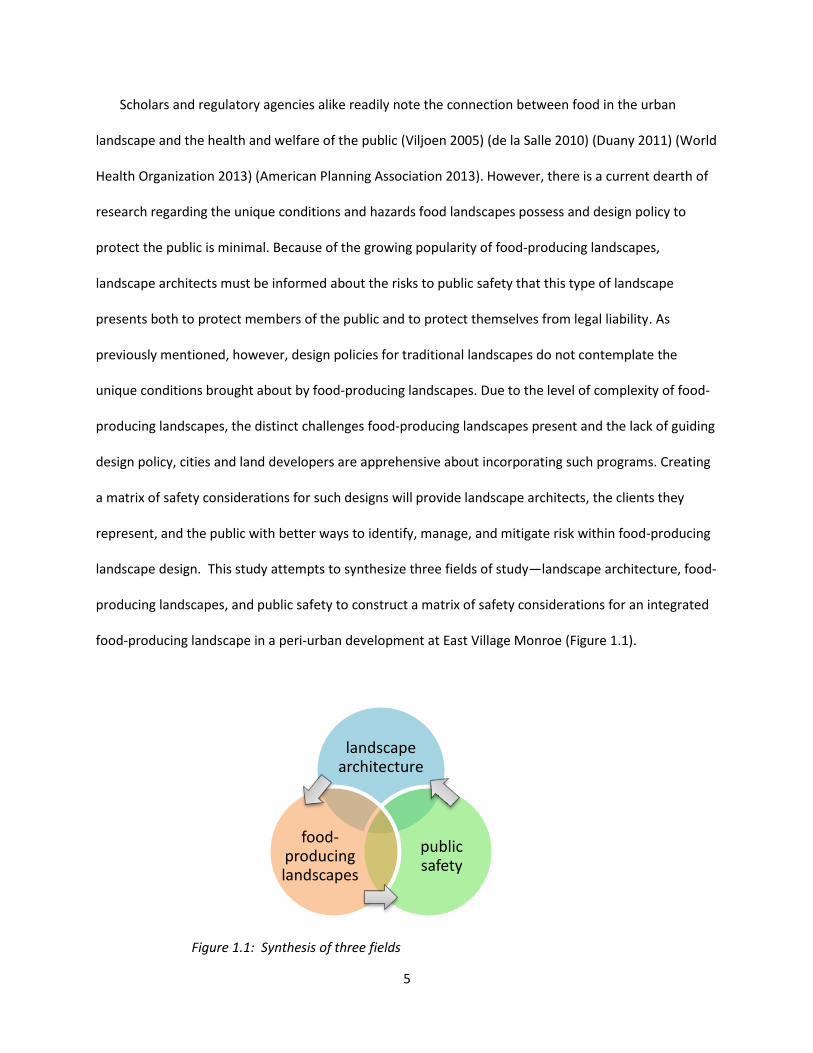
Scholars and regulatory agencies alike readily note the connection between food in the urban
landscape and the health and welfare of the public (Viljoen 2005) (de la Salle 2010) (Duany 2011) (World
Health Organization 2013) (American Planning Association 2013). However, there is a current dearth of
research regarding the unique conditions and hazards food landscapes possess and design policy to
protect the public is minimal. Because of the growing popularity of food-producing landscapes,
landscape architects must be informed about the risks to public safety that this type of landscape
presents both to protect members of the public and to protect themselves from legal liability. As
previously mentioned, however, design policies for traditional landscapes do not contemplate the
unique conditions brought about by food-producing landscapes. Due to the level of complexity of food-
producing landscapes, the distinct challenges food-producing landscapes present and the lack of guiding
design policy, cities and land developers are apprehensive about incorporating such programs. Creating
a matrix of safety considerations for such designs will provide landscape architects, the clients they
represent, and the public with better ways to identify, manage, and mitigate risk within food-producing
landscape design. This study attempts to synthesize three fields of study—landscape architecture, food-
producing landscapes, and public safety to construct a matrix of safety considerations for an integrated
food-producing landscape in a peri-urban development at East Village Monroe (Figure 1.1).
Figure 1.1: Synthesis of three fields
landscape architecture
public safety
food-producing landscapes

6
DESIGN STRUCTURE MATRIX
A matrix, by definition, is something within which something else originates or develops. It can
also describe a rectangular array of mathematical elements that can be combined to form sums and
products with similar arrays having an appropriate number of rows and columns, or it can be something
resembling a mathematical matrix—a rectangular arrangement of elements into rows and columns.
Matrices have been used in a variety of ways as an efficient method to perform both the
analysis and the management of complex systems. Steward (1981) developed a particular type of
matrix, the Design Structure Matrix (DSM) (Figure 1.2), as a tool for identifying the dependencies
between tasks and for sequencing the development process. In this type of matrix, tasks are assigned to
a row and a corresponding column. Reading down the column reveals which tasks receive information
from the task corresponding to the column. Reading across a row reveals all the tasks whose
information is required to perform the task corresponding to the row. A DSM (Figure 1.2) could
potentially provide an effective low-level design process based on physical design parameter
relationships (Browning, 2001).
Figure 1.2: Design Structure Matrix (Carrascosa 1998)
7
Since Steward’s landmark paper in 1981, other professionals have adopted and adapted the
DSM to their respective fields. For example, in a joint effort, Crime Prevention Victoria, the Department
of Sustainability and Environment, the Heart Foundation, and The Cancer Council Victoria published
“Design for Safe and Healthy Communities: The Matrix of Like Design Considerations.” Their matrix was
developed to assist planners when considering guidelines that would influence the design of the built
environment. Similar to this charge, the matrix presented below provides a framework of considerations
for landscape architects when designing food-producing landscape in the peri-urban context. The matrix
model supports an integrated approach to designing a healthy and safe food-producing landscape and
provides a practical guide to landscape architects. This approach helps to synthesize a range of safety
considerations specific to food-producing landscape design in peri-urban developments. While the
matrix can be used to aid design, it is important to consider every situation in the context of its unique
surroundings.
Landscape architects need to consider how their design will impact the health, safety, welfare,
and access of people and their environment (Schatz 2003, 4); This thesis presents a DSM model tailored
to the analysis of safety design guidelines in food-producing landscapes in a peri-urban environment and
explores the efficacy of such a matrix as a management tool for analyzing such risk in food-producing
landscape design. The “Matrix of Food-Producing Landscape Design Considerations in the Peri-Urban
Landscape” presented in Chapter V, is a practical tool that can be used to render site specific guidelines
that can influence the safe design of food-producing landscapes in the public realm of a place.
The challenge for a landscape architect is to design a food-producing landscape that achieves
the functional, cultural, and aesthetic goals of the project while ensuring safety for the public. To meet
this challenge, this thesis sets out to build an understanding of how a landscape architect can identify,
manage, and mitigate situations in a food-producing landscape design that are potentially hazardous to
the public. To this end, this thesis relies on the use of two methods familiar to landscape architecture

8
research: classification (or taxonomy) and case study review. Both methods are used to populate the
matrix for East Village Monroe and, ultimately, build the contents of the matrix to answer the question
of how landscape architects can provide an integrated and safe food-producing landscape.
Chapter II utilizes the first method, presenting three food-producing landscape classification
systems. Classifying food-producing landscapes is important because the size, scale, and productivity
can have varying impact on safety. Through studying the typologies of food-producing landscapes, a
designer will be more apt to recognize the risks associated with each type.
Chapter III employs the second research method—the case study review. This Chapter explores
Village Homes and various other examples of historic food-producing landscape movements in the
United States. The Village Homes development is an important example because it is a food-producing
landscape that is fully integrated into a residential community. Other historical examples show how
civilizations have utilized edibles in the built environment for centuries.
Chapter IV maps the legal liabilities and public policies that help to shape the profession of
landscape architecture. This Chapter investigates the responsibilities of the landscape architect from
the eyes of ASLA, the profession’s governing professional organization; legal patterns in U.S. case law
related to food-producing landscapes; and policies from municipalities across the United States relating
to and regulating food-producing landscapes.
The two methods of landscape architectural research described above are the foundation for
populating a DSM of safety considerations to assist in the analysis of the integrated food-producing
landscape design at East Village Monroe. Chapter V will reintroduce East Village Monroe, discuss the
particulars of the site, disclose the process for creating an integrated food-producing landscape, and
present a master plan for the mixed-use development.
As design professionals, understanding the risks and liabilities is paramount to protecting those
encountering designed landscapes. Beyond the project at East Village Monroe, an overarching goal of

9
this study is to advance research toward designing safe, integrated food-producing landscapes in the
built environment—physically safe for public participants and legally safe for the landscape architects
who design them.
DELIMITATIONS
From the aspect of safety, in general, microbial food safety protocols is outside the lens of the study.
Food-producing landscape maintenance programs including protocols microbial contamination are
issued by individual state agricultural departments. For example, the California Division of Agriculture
and Resources publishes a thorough manual on the subject, “Key Points of Control & Management for
Microbial Food Safety: Edible Landscape Plants and Home Garden Produce.” Public health departments
also have resources available for restaurant designers and restaurateurs to mitigate health risks.
DEFINITIONS
The intent of this section is to establish a common design language for food-producing
landscapes. The reason to inventory the widely varied nomenclature of food-producing landscapes is to
synthesize a design language that will help to establish the vocabulary, syntax, and media for recording,
devising, assessing, and expressing design ideas for food-producing landscapes. (Archer 2005, 8).
In an effort to provide an understanding of design services to the public, contemporary
designers are forging new definitions. There are a multitude of definitions for the term, “food-producing
landscape.” For this thesis, food-producing landscape refers to a piece of land or property designed for
human interaction and cultivated for human consumption. The term food-producing landscape
encompasses all three: urban agriculture, peri-urban agriculture, and rural agriculture.
Landscape functions provide specific services, often referred to as “ecosystem services” (Lovell
and Johnston 2009). These can be defined as “benefits human populations derive, directly or indirectly,

10
from ecosystem functions” (Costanza et al. 1997). Food-producing landscapes, in regard to this thesis
are a type of ecosystem service and classified in a sub-category as a provisioning services. Providing food
or fodder, are two examples.
Due to its widespread use in contemporary vernacular, the term “urban agriculture” is
presented. The phrase urban agriculture is a bit of a misnomer. It can be seen outside the urban
landscape – in more of a suburban setting. Additionally, urban agriculture can encompass more than just
agriculture. Though there are many variations of the definition of urban agriculture, a central thread is
woven into all of them: food-produced in a built environment. Presented here is a comparison of three
sample definitions of the term.
The first sample views urban agriculture as an “industry that produces, processes and markets
food and fuel, largely in response to the daily demand of consumers within a town, city, or metropolis,
on land and water dispersed throughout the urban and peri-urban area, applying intensive production
methods, using and reusing natural resources and urban waste to yield a diversity of crops and
livestock” (Mougeot). This definition from Mougeot differs from the Council on Agriculture, Science and
Technology (CAST) which more thoroughly includes the purpose of urban agriculture.
Second, CAST defines urban agriculture, “as a complex system encompassing a spectrum of
interests, from a traditional core of activities associated with the production, processing, marketing,
distribution, and consumption, to a multiplicity of other benefits and services that are less widely
acknowledged and documented. These include recreation and leisure; economic vitality and business
entrepreneurship, individual health and well-being; community health and well being; landscape
beautification; and environmental restoration and remediation” (Council on Agriculture, Science and
Technology 2013).
In the third definition, the Urban Ag Council of Georgia takes a different approach and does not
explicitly mention food at all, but incorporates the sustenance benefit to humans as part of a natural

11
system. “Urban agriculture is the creation, growth, introduction, and management of constructed
landscapes designed to support and enhance natural environmental systems and a sustainable quality of
life through mitigation of land altering activity” (Urban Ag Council of Georgia 2013).
It is important to disclose the multiple definitions of the term urban agriculture to understand
the breadth of its use. Much of the general public will refer to the food-producing landscapes in the
urban and peri-urban settings as urban agriculture, however, for determining safety risks, the two types
of landscapes are differentiated.

12
CHAPTER II
CLASSIFICATION OF CONTEMPORARY FOOD-PRODUCING LANDSCAPES
Across academic discourse, food-producing landscapes are given many classifications—urban
agriculture, agricultural urbanism, and agrarian urbanism to name a few. Each designation is a response
to its urban context or its social, political, or environmental ideology. In the following discussion, two
existing classification systems are presented and insights are suggested as to why they are oriented they
way they are. A third classification system is then proposed for potential capability for overcoming the
deficiencies of the two established systems. Examples of food-producing landscapes for each
classification are provided. Each type of food-producing landscape is derived from the urban planner,
designer, or theorist who coined the word.
Tables 2.1 and 2.2 set forth spectrums of food-producing landscapes from two different
perspectives. The first is organized from the pedestrian-scale; the second is from an urbanism
perspective. As the graphs suggest, there are no clear boundaries between food-producing landscape
types within each classification system as types are often suitable for multiple categories. Just as food-
producing landscape classifications blur the boundaries between city and country, the issues addressed
by food-producing landscapes overlap and interconnect (Mougeot 2006). The Chapter culminates in the
call for a new classification: performance-oriented. The intention of creating a new classification is to
address the faults of the two existing theories and to form one which possesses greater considerations
for public safety.

13
PEDESTRIAN-ORIENTED CLASSIFICATION
Pedestrian-oriented food producing landscapes or “Agricultural Urbanism” as Porter refers to it,
“parallels the urban transect through a planning and design approach” (Table 2.1) (Porter, 116). Through
a “context-appropriate design strategy,” Agricultural Urbanism (AU) attempts to organize agricultural
landscapes based on program (function) and scale (form). Porter states, “By design, Agricultural
Urbanism is organized around more pedestrian-scaled systems in the exploration of similar relative
scales, comparing hierarchies of urban design with human-scaled agricultural production units.” The
human scales range from the “yard” for the kitchen garden to the “pedestrian-shed unit” or “section”
encompassing large-scale agricultural operations. Food production for spaces along the spectrum is
based on “two fundamental dimensions: the size of the human body (comfortable working positions)
and the 100-foot, 30-meter, row” (Porter, 117). Porter explains the essence of a pedestrian-oriented
scheme as, “the layering of systems and programming, based on a fundamentally human-scaled
relationship with productive landscapes, affords Agricultural Urbanism tremendous opportunities for
placemaking, perhaps the most tangible and enduring form of sustainable design” (Porter, 118).
As the name suggests, a pedestrian-oriented classification puts great emphasis on the
pedestrian. Herein lies a problem: not every pedestrian is the same. Each pedestrian is different with a
unique range of mobility. Additionally, considerations for safety must also reach those bound to
wheelchairs. With the increasing number of personal mobility devices, such as electric scooters, a
person’s pedestrian shed may fluctuate throughout a person’s lifetime. Therefore, safety in the food-
producing landscape using a pedestrian-oriented approach must be evaluated by each individual it is
intended to serve.

14
Urban Program, Unit, & Scale
Agricultural Program, Unit, & Scale
Complete range of urban services: live, work & play: access to regional transportation network & park system
Pedestrian-shed
from
region
al plan
nin
g to p
lacemakin
g>>
160+ acres
fro
m t
he
hu
man
bo
dy
to t
he
pla
ce >
>>>
Section
Complete range of crops, including production at scale of grains, legumes, livestock & dairy; forestry viable
Pedestrian-friendly mix of land uses & services, including neighborhood scale commercial, social gathering spaces Neighborhood
40+ acres
Quarter Section
Small scale grain & livestock production; specialty forestry products; fully diversified "homestead"
Mix of housing types; pedestrian circulation to access larger neighborhood services/amenities Block 5+ acres Farm
Commercial orchard operation; scale affords wholesale market potential of variety of crops
Designated land use, defining neighborhood "function," open space Site / Parcel 1+ acres
Large Garden
Mixed produce & small fruit production; small scale orchard; typical "farm unit"
Residential / Commercial unit(s); access Lot
1/8+ acres
Garden Plot Micro-share CSA; specialty crops
Open space / Recreation Yard 400+ sq. ft. Row Kitchen gardens
Table 2.1: Edward Robbins Porter "Urban & Agricultural Programs by Unit and Scale"
URBANISM-ORIENTED CLASSIFICATION
Andres Duany and the firm Duany Plater-Zybeck published “Garden Cities” in 2011 which
takes an urbanist approach. The book proposes combining natural and social diversity through
various development-to-open space ratios along a rural-to-urban transect (Duany 2011). The
“Agrarian Transect,” introduced in the book, serves as an analytical tool and a method for
organizing the built environment that can be administered similar to zoning (Duany 2011). Like
Porter, Duany refers to the effort of food-production in the landscape as Agricultural Urbanism
(AU). Though Duany’s AU describes a different landscape than Porter’s AU. By Duany’s definition,
AU refers to settlements equipped with a working farm. “The agriculture is economically
associated with the communities’ residents and businesses, but it is not physically or socially
integrated” (Duany 2011, 8). One of the key differences in Duany’s theory of AU, is the “transect

15
of food production” which correlates to the level of mitigation demanded by the amount of land
consumed (Duany 2011). Examples include two developments discussed in the next Chapter,
Ebenezer Howard’s Garden City and Village Homes.
Duany’s transect closely follows Von Thunen’s theory of bid-rent curves from the urban
core which helps to define and delineate land use (Boone and Modarres 2006, 55). Von Thunen’s
theory suggests the most productive activities will thus compete for the closest land to the
market and activities not productive enough will locate further away (Fujita and Thisse 2002, 43).
However, as Boone and Modarres point out, “While an elegant theory, the reality is different as
the bid-rent curve is interrupted by natural features such as rivers or undeveloped land or a
collective decision to protect land for specific uses, such as paths.” One example of land use that
causes “interruption” in the urban-oriented classification system is the greenway. This point is
illustrated with stories of exotic wildlife that follow greenways to the very doorstep of the urban
core and, in some instances, live within it.
Urban Program, Unit, & Scale
Agricultural Program, Unit, & Scale
Wilderness condition & unsuitable for development T-1 Natural
from
un
man
aged to
inte
nsely m
anaged
>>
LEAST DENSE
fro
m u
rban
to
ru
ral >
>>>
Rural Ag Foraging
Sparely settled; uses: woodland, farmland, irrigable desert. Typical buildings: agricultural buildings T-2 Rural
LESS DENSE Rural Ag
Tractor farms; Hand tended farms & orchards
Low-Density residential areas, some retail. T-3 Sub-urban
MED. DENSITY
Periurban Ag
Hand tended farms & orchards; front yard gardens; rear yard gardens; community and allotment gardens
Mixed-use, primarily residential. Many building types: shops, houses, rowhouses, small apartment buildings
T-4 General Urban DENSE
Intraurban Ag
Front yard gardens; rear yard gardens; community and allotment gardens; Roof Gardens, Balcony Gardens, Window Gardens
Higher-density, mixed-use buildings with shops, offices, rowhouses, and apartments.
T-5 Urban Center
MORE DENSE
Intraurban Ag
rear yard gardens; community and allotment gardens; Roof Gardens, Balcony Gardens, Window Gardens
Mixed-use with greatest density and building height. Only large towns & cities have Urban Core Zones.
T-6 Urban Core
MOST CORE
Intraurban Ag
Roof Gardens, Balcony Gardens, Window Gardens
Table 2.2: Andres Duany & DPZ "Food Along the Transect"

16
PERFORMANCE-ORIENTED CLASSIFICATION
Developers and municipalities alike are increasingly requesting landscape architects to design
food-producing landscapes, most notably marketed under the moniker “urban agriculture.” However,
the term does not paint the entire picture of food-producing landscapes in urban environs. Industries on
opposite ends of the economic spectrum are branding their offerings as urban agriculture. On one end
of the spectrum are the commercial landscape industries. Three major associations of landscape and
irrigation contractors in Georgia, the Metro Atlanta Landscape and Turf Association, the Georgia Sod
Producers Association, and Georgia Turfgrass Association, have consolidated under one name, the
Urban Ag Council. On the other end of the spectrum are locally based guerilla gardening units, popular
in London and New York, which sometimes illegally, and usually by the cover of night, transform
blighted urban areas into edible oases.
Because of the unique considerations each presents, this thesis places food-producing
landscapes in a performance-oriented classification system into three categories: urban agriculture,
peri-urban agriculture, and rural agriculture.
Defining urban agriculture is complicated by the fuzzy and imprecise definition of “urban” and
the difficultly of determining where “urban” begins and ends. The interrelatedness of urban agriculture
with the ecology, and fiscal and social economies of cities forges a distinct but complementary role to
peri-urban agriculture and rural agriculture.
According Mougeot urban agriculture is the cultivation of landscapes to produce food for human
consumption and fodder for animal consumption within the urban context (Mougeot 2006). Urban
agriculture can entail the growing, processing, and distribution of food and non-food plant and tree
crops as well as the raising of livestock, directly for the urban market within the urban area. This
definition deviates from Mougeot’s original definition of urban agriculture by not including peri-urban
17
areas. Application of urban agriculture includes crop and animal production in backyards, farming on
rooftops, in window boxes, on roadsides, beside railroads, beneath high tension lines, within utility
rights of way, in vacant lots of industrial estates, and on the grounds of schools, hospitals, prisons, and
other institutions, as well as aquaculture in tanks, ponds, and pens in rivers (Mougeot 2006).
Peri-urban agriculture is found in suburban areas at the urban-agricultural edge. This “edge”
occurs in areas where the distinction between town-like and farm-like is less defined. Historically, peri-
urban areas were sources of fresh fruits, vegetables, and dairy and meat products as these areas around
many large American cities have the soil to produce a broad array of food products (Lyson 2004). As
cities expand, they frequently engulf nearby small towns and farms and, in these peri-urban areas, some
residents continue to farm whatever land is left. In some instances, urban dwellers seek refuge in small
plots of land on this urban fringe, either shuttling out weekly or spending an extended period of time
there to tend the crops during the growing season. Howard’s Town-Country, the Schrebergarten plots
in Germany, Duany’s Agricultural Urbanism, and Village Homes in Davis, California are examples of a
peri-urban agriculture. Some contemporary neotraditional neighborhood developments such as Serenbe
in Chattahoochee Hills, Georgia or Farmstead, just outside the urban fringe of Montgomery, Alabama
blend traditional amenity packages with agriculturally related activities in an attempt to lure potential
home buyers. Similarly, the developers of EVM are exploring a food-producing landscape program
central to their offering, as exhibited in the design study example in Chapter V. Unlike agro-centric
communities like Serenbe and Farmstead where agriculturally related activities are sequestered to a
portion of the development, EVM’s food-producing landscape is fully integrated into the entire
landscape of the site.
Many definitions of urban agriculture in the nomenclature of food-producing landscapes include
peri-urban areas. However, Boone and Modarres challenge these definitions, suggesting that there
should be a distinction between urban agriculture and peri-urban agriculture. “If urban agriculture is to
18
be treated as something extraordinary, or as different from typical farming, it should refer to farming
activity within the built-up areas of cities, in places where one would not expect farming to occur”
(Boone and Modarres 2006, 89).
CLASSIFICATION SUMMARY
Classification of food-producing landscapes in regard to where, how big, and who is involved, is
becoming increasingly complex as new theories and classifications have recently been posited by leading
urban design academics and theorists.
Urban-oriented food-producing landscapes as a classification strategy is difficult because
defining a level of urbanism is difficult. An urbanism-oriented scheme seems to identify issues with scale
and intensity of farming but does not respond well to a city’s movement becoming more closely tied to
the ecological system. By definition and its classification system, an urban-oriented scheme ignores the
necessity of greenways and ecological corridors in penetrating the urban core. Pedestrian-oriented
design, on the other hand, addresses issues of basic human needs such as the importance of the human
experience and place-making; however, it fails to recognize that pedestrian sheds are different for
everyone.
Filling the gaps in both the pedestrian-oriented and the urbanism-oriented classification of food-
producing landscapes, the introduction of a new theory of a classification, one following a model of
productivity, seems like a logical evolution. If in pedestrian-oriented classification the size of the farm
dictates what is grown and in an urbanism-oriented classification, density and urban form dictates what
is grown then in a performance-oriented classification, what amount can be grown dictates how it can
be grown. A performance-oriented classification of food producing may prove to be a classification that
can respond to public safety concerns while enabling the benefits of food-producing landscapes in any
environment.

19
CHAPTER III
U.S. HISTORY OF FOOD-PRODUCING LANDSCAPES URBAN AND PERI-URBAN ENVIRONMENT
Interest in food-producing landscapes is not a new phenomenon, however, the idea that much
of the human population grows fruits and vegetables near their dwellings might seem foreign to modern
American society. For many developing countries, urban agriculture is more of matter of economic value
or daily nutritional necessity than of recreational benefit or aesthetic preference (Viljoen 2012, 97)
(Lewcock, 1996). For example, in Chinese cities as a whole, 85 percent of vegetables consumed by
residents are produced within the limits of those cities. Some Chinese cities, including the populous
cities of Shanghai and Bejing are fully self-sufficient in vegetable production (Viljoen 2012, 97) (Hough,
1995).
In literature, food-producing landscapes can see throughout human history. In the book of
Genesis, the Garden of Eden is described as the place where God placed beautiful trees that produced
delicious fruit. Examples of food production in important seats of power include early formal gardens
which adopted the “shape” of Eden as described in the Bible. In France, just outside of Paris at
Versailles, Louis the XIV held many illustrative festivals and parties for his garden’s visitors. During
events fruit trees were placed in large vases in the great allées of the garden. One walk lined with
Portugese oranges, another with cherry trees, a third with apricots and peaches, a fourth with currant
bushes from Holland, and the last with various sorts of pears (Thompson 2006, 147). Fruit-laden trees
were temporarily placed along major circulation routes for the events then moved to more suitable
locations after the parties concluded.
Long before “sustainability” became part of the contemporary design vernacular, most cities
established themselves on extremely fertile ground. In major cities of pre-Industrial Revolution America,

20
livestock could be seen roaming and grazing in common areas deep within the urban core. Boston
Commons in Boston, Massachusetts was designed to be a common area for grazing cattle. In Athens,
Georgia the black, cast iron steel fence which divides the University Georgia campus and the city is a
reminder of a time when cattle were once seen as a threat to the green grass of the north campus’s
quadrangle.
In the U.S. prior to the nineteenth century Industrial Revolution, without the aid of high capacity
transportation vehicles or preservation techniques such as refrigeration, food had to be consumed near
where it was grown (Viljoen 2012, 97). In Savannah, Georgia, city founder James Oglethorpe’s Plan for
Savannah understood the basic need for a civilization to have access to food when he planned the city in
1733. Oglethorpe established a hierarchy of green commons within a pedestrian shed—from the
backyard herb garden to the common square’s community garden to the district park to the rural
hinterland. The spatial hierarchical arrangement connected all dwellers through accessibility. Each open
space was multi-purposeful—responding to social, military, environmental, and philosophical needs
(Reiter 2004). A coexistence of homes, markets, public buildings, and sacred places were interspersed
with kitchen gardens, farms, and common grazing land that delivered food for the settlement’s
population. Oglethorpe’s plan remains one of the most studied urban designs in the world and he
continues to be an influential figure for many planners and designers. Ebenezer Howard, a city planner
and innovator, whose work is presented later in the Chapter, also incorporated notions of agricultural
planning in his urban designs.
The nineteenth century Industrial Revolution in the West marks a period of great population
shift to urban centers, and since this time food movements in the urban landscape can be seen in a
cyclical pattern. These movements are commonly tied to a particular event or events, political climate,
or economic condition. In this Chapter, examples of historical food movements are examined, including

21
the surrounding conditions that may have created them, the designers or organizers behind them, and
the theorists who advocate their existence in the built environment.
Post-Industrial-Revolution America has seen agricultural practices creep back into the confines
of urban environments at certain moments in history. These moments are represented by movements
that captivate a generation of people growing food in the urban landscape. Reasons for needing
productive gardens vary with the socio-political, economic, and environmental conditions surrounding
each movement (Figure 3.1). More often than not, the biggest stimulus for urban food production has
been war (Viljoen 2005). The following Chapter is a brief introduction to a few movements in America
and abroad including indications to the crux of their creation.
Figure 3.1: Timeline of Urban Garden Movements in America
GARDEN CITY MOVEMENT
“At last, the industrial town’s indifference to darkness and dirt was exposed for what it was, a
monstrous barbarism” (Mumford 1961, 476). With nineteenth-century industrial achievements and the

22
increased density in towns and cities came repeated outbreaks of malaria, cholera, typhoid, and
distemper. The city became dark, smoky, and dirty. Families slept next to the sounds of the larger
manufacturing machines and communities became fragmented in the wake of capitalism. “Thus the city,
from the beginning of the nineteenth century on, was treated not as a public institution, but a private
commercial venture to be carved up in any fashion that might increase the turnover and further the rise
in land values.” (Mumford 1961, 426). It was not long before city dwellers demanded a higher grade of
hygiene, municipal responsibility, and protection of the rapidly declining natural resources. “To bring
back fresh air, pure water, green open space, and sunlight to the city became the first object of sound
planning…” (Mumford 1961, 476).
Concerned with the social ills of London, former English court reporter Ebenezer Howard set out
to change the wrongs of the industrial metropolis. In 1892, Howard proposed his ideas for solving the
urban blight to the public where he was heavily criticized. It was not until 1898 when a friend from
America gave him the financing to publish his book “To-Morrow: A Peaceful Path to Real Reform.” A
year later he was contacted by a prominent lawyer in London who introduced him to George Cadbury
and W.H. Lever (Schaffer 1982, 17). Cadbury and Lever, two philanthropic capitalists, understood the
plight for housing reform and proposed utopian villages as a solution. Both were willing to give Howard
the capital he needed to finance his vision. In 1902, after significant revisions, the book was reprinted
with the title “Garden Cities of To-morrow.”
Before Howard’s ideas came to fruition, there were two alternatives–town life or country life.
You were either a farmer in the agricultural fields or a factory worker trapped in the confines of the
smoke, odor, and dust of the city. The Garden City, however, became “a third alternative, in which all
the advantages of the most energetic and active town life, with all the beauty and delight of the
country…the spontaneous movement of the people from our crowded cities to the bosom of our kindly

23
mother earth” (Howard 1965, 49). Howard carried with him a diagram to explain his concept that he
entitled “The Three Magnets,” consisting of Town, Country, and the newly created Town-Country (which
was to be the location of his Garden City.) The Town galvanized economic capital, the Country possessed
an intrinsic bucolic beauty, while the advantages of the Town-Country are seen to be free from the
disadvantages of either” (Howard 1965, 47).
In his book “Garden Cities of To-morrow,” Howard describes the physical nature of the Town-
Country. The book codified the size of land needed for a Garden City and the proportion of lands set
aside for industry, commerce, and residents. Howard also prescribed transportation plans. “Six
magnificent boulevards–each 120 feet wide–traverse the city from the centre to circumference dividing
it into six equal parts or wards” (Howard 1965, 51). On the edge of town one would find the “Grand
Avenue,” a 420-foot-wide green belt that would house public schools, playgrounds, gardens, and
churches of all denominations. Target population numbers were also provided: “about 30,000 in the city
itself, and 2,000 in the agricultural estate” (Howard 1965, 54). Howard spoke of an outer ring, a place
where the industrial efforts were concentrated. He suggested that the separation of uses created an
arrangement that would increase production efficiencies and a reduction of traffic congestion. He would
continue to offer his solutions to urban problems by applying “the best systems adapted for various
purposes” (Howard 1965, 55).
In 1903, 35 miles north of London in North Hertfordshire, England, a small investment company
broke ground on what was to become the world’s first Garden City. Architects Barry Parker and Harry
Unwin were commissioned to create the master plan for the new community–Letchworth Garden City
was to combat the social ills and urban deterioration created by the Industrial Revolution. The new
Garden City was meant to be run by a nonprofit public body and reinvest all taxes and fees generated
through the 5,500 acre estate for the further development of the city. Their mission was, “To create,

24
maintain and promote a vibrant, quality ‘environment’, for all those who live in, work and visit the
world’s first Garden City” (Letchworth Garden City Heritage Foundation).
Howard’s efforts were not without critics. His belief that science and technology could assist the
social progress of the age caused Jane Jacobs to doubt the methodology. “Howard attacked the problem
of town planning much as if he were a nineteenth-century physical scientist analyzing a two-variable
problem of simplicity. The two major variables in the Garden City concept of planning the quantity of
housing (or population) and the number of jobs” (Jacobs 1961, 435). Jacobs goes on to describe this as a
closed system unable to cope with the mass number of variables that are created by people’s needs.
As Hall and Ward point out in the 2003 edition of “Garden Cities for To-Morrow,” Howard
intended the Garden City to be far more than a town; to him it was the physical iteration of a “third
socio-economic system” which was superior to both industrial capitalism and communism in that it
would be a true exercise in Krotophkin’s idea of anarchist cooperation in which local self-government
would assume fiscal control of the community instead of remitting taxes to a central government
(Howard, 2003) (Walker, 81).
Although only one other community was constructed strictly following Howard’s “Garden City”
outline, his concept left an indelible mark on American regional planning. Though physical safety within
the food-producing components of Howard’s Garden Cities are not specifically mentioned, it is
noteworthy to recognize his contributions to forging ideas of how agriculturally related activities could
be integrated into residential developments in the peri-urban realm.
SCHREBERGARTEN
Schrebergarten plots were community gardens developed as a social program in nineteenth-
century Berlin by Dr. Daniel Gottlieb Mortiz Schreber. The garden plots were intended to provide a place

25
for active recreation for youth and to serve as an educational tool for the basics of gardening. Residents
were allotted plots in a green belt along the periphery of the city. In the wake of World Wars I and II,
many Germans sought refuge in these small garden cottages and relocated there permanently (Haeg
2008, 19). Since 1983, the Bundeskleingartengestz, or Federal Small Garden Law, policy has served to
regulate the size, operations, and aesthetic qualities (e.g., color and style) of garden shelters one is
allowed to keep on a plot. Maintenance programs like mowing and tilling with large machinery is also
regulated by this policy. Today, there are still about 1.4 million allotment gardens in Germany covering
an area of 470 square kilometers.
ST. ANNS ALLOTMENTS
Though the exact date of the establishment of St. Anns Allotment gardens in Nottingham,
England is unknown, the first documented enclosure of the land at Hungerhills is recorded in 1604 when
30 burgesses rented plots of two to three acres for a rent of £15 a year. Due to the high cost of fencing
and the propensity of crop-devouring deer, the rent was reduced to £13 the following year. The St. Anns
Allotments and 670 individual gardens connected by three sites—Hungerhill Gardens, Stonepit Coppice
Gardens and Gorsey Close Gardens are the largest detached town garden in Britain and possibly the
oldest existing allotment gardens in the world (Allotments, 2012).
By the 1830s, the individual allotments provided space and opportunity for those who lived in
the city to grow their own food and escape the confines of the urban life. They were used and enjoyed
by working class urban dwellers without space to grow gardens. Many people had vacation houses on
their garden plots and the plots were places of leisure. Through times of economic depression and war
the allotment gardens were used more out of necessity than pleasure as families would spend more
time growing their own fruits and vegetables (Allotments, 2012).

26
VICTORY GARDENS
Like all wars, the demands of World War II placed a heavy burden on American resources,
especially food resources. Farmers were drafted to serve in the military thereby reducing food
production for citizens. The remaining farmers produced food for the military and little was left for
civilian families. President Franklin Roosevelt mounted a campaign to encourage Americans to grow
food on their own properties in suburban and urban communities. By the end of World War II, over 80%
of American households were growing foods of their own (Haeg 2008, 18).
BACK TO THE GARDEN MOVEMENT
In the 1970s in America, new interest in community gardening grew as an expression of urban
activism, a new environmental ethic, and in response to social unrest. Garden programs emerged, such
as New York’s Green Guerillas and Boston Urban Gardeners (BUG) (Boston Urban Gardner: Recorders,
1976-1989, 2012). In 1976, the USDA sponsored the Urban Gardening Program that established urban
offices to promote vegetable gardening and community gardens in 16, and later 23, cities (Lawson,
2000). BUG began in 1976 as a voluntary association of community leaders and garden organizers from
the South End, Roxbury, and Jamaica Plain, and quickly grew into a staffed organization with a number
of funding sources. The belief that "urban gardening contributes significantly to good mental health and
nutrition, urban neighborhood vitality, aesthetics, and environmental enhancement" led BUG to serve
as a resource for and to work on a variety of projects with people in low-income communities
throughout Boston. BUG also worked with the Boston Housing Authority, Massachusetts Department of
Food and Agriculture, and other government and community organizations (Boston Urban Gardeners:
Recorders, 1976-1989, 2012). One of the organization’s initiatives related to public safety in a food-
producing landscape is its involvement in educating people about how to reduce the risks of heavy
metals in the urban landscape. In 1978, the National Center for Appropriate Technology (NCAT) granted

27
funding to BUG to write a handbook on heavy metals. BUG created a Toxicity Task Force in 1977 and
joined the Ad Hoc Task Force on Heavy Metals with the Suffolk County Extension Service, the
Massachusetts Department of Food and Agriculture, and other groups (Boston Urban Gardeners:
Recorders, 1976-1989, 2012). The task force and BUG worked on a soil testing project and prepared
instructions for soil testing and safe gardening.
Post-WWII Detroit has benefitted from the support of a variety of federal and local programs
supporting food grown in the urban context. These programs include the USDA’s Expanded Food and
Nutrition Education Program of the 1970s and 1980s and the Community Food Projects Competitive
Grants Program that was formed in 2006. The Farm-A-Lot program, started in 1975, was run by the city’s
recreation department until budget cuts terminated the program at the turn of the century. The
Program offered tilling assistance, seeds and transplants, and gardening advice to local gardners. Other
grassroots groups spawned in Detroit to support urban agriculture including: the Garden Angels, which
organized the intergenerational transfer of skills and knowledge; the Detroit Agricultural Network, which
organized networks for sharing resources; and more recently, the Garden Resource Program
Collaborative, the D-Town Farm, and a myriad of other organizations created to develop gardens, offer
training and resources, and organize gardeners to build their capacity through innovative agricultural
methods and market gardens.

28
Figure 3.2: (Clockwise from top left): The
Garden of Eden, Figure 3.3: E. Howard’s Garden City with allotments integrated into the urban fabric,
Figure 3.4: Court of Oranges at Versailles, France, St., Figure 3.5: Anns Allotment gardens.
VILLAGE HOMES
Rooted in the “nurture in nature” era is the project of Village Homes, a 242-unit development in
Davis, California, 15 miles from Sacramento. Constructed from 1974-1976, Village Homes is the brain
child of landscape architect and town planner Mike Corbett and his wife, Judy. Stemming from the

29
environmental movement of the early 1970s, innovative concepts went into the Corbetts’ planned unit
development. The program for Village Homes is a catalog of best practices in environmental planning
and design, not just for 1970, but for today. The plan includes passive solar home orientation, large
common spaces, an open decision-making process for residents, storm water drainage channels, and a
food-producing landscape.
Village Homes has been critically acclaimed by the press and academics. Literature abounds on
the various aspects of Village Homes including, but not limited to, the physical design, the social
dynamics, and economic status of the development. In 2001, Village Homes was one of three prototype
case studies for the Landscape Architects Foundation’s newly founded Land and Community Design Case
Study Initiative series. This series was designed to promote an in-depth, multi-dimensional approach to
case studies and to provide for uniformity in format and method. The approach combines observational,
attitudinal, archival, historical, and quantitative methods in a concise report, easily accessible for
students and professionals.
Witten by Mark Francis, “Village Homes: A Case Study In Community Design” accomplishes three
objectives: it is a synthesis of existing information and literature on Village Homes; it shows the project’s
significance for landscape architecture and urban design showing the importance so it can be replicated
in the future; and it provides a critical review of the project so that future researchers can learn from
both the project’s successes and failures.
One limitation of the design of Village Homes is the blurred boundary between public and
private realms (Francis 2003, 36). Several types of open space are provided in Village Homes, including
private gardens, common areas, agricultural lands, turf areas for sports, and landscaped areas. These
spaces are described in the official publications of Village Homes produced by the Village Homeowners
Association as “household commons,” “greenbelt commons,” and “agricultural lands.” Residents hold
common interest in all three types of land. Common lands are specified by the Village Homeowners

30
Association to be used for three purposes—enjoyment, flowers and food, and profit. The 300-tree
almond orchard typifies the three-pronged approach serving as passive recreation areas, providing
scenic beauty, and, almonds for sale which the residents of the community financially benefit from.
The farm-like landscape serves as a powerful symbol for the community. Without the vineyards,
orchards, and community gardens, Village Homes would appear much more like a conventional
development. It demonstrates that there is a value to incorporating small scale agricultural uses within
existing developments, rather than the notion that farms must exist apart from where people live
(Francis 2003, 37).
Much of the plant material in Village Homes is edible and includes oranges, almonds, apricots,
pears, grapes, persimmons, peaches, cherries, and plums. “An important advantage of neighborhood
agriculture is that it allows for a healthy ecological balance that cannot be maintained in large-scale,
single-crop plantings. Because the plantings of any one species are small and separate, they do not
encourage pests and diseases to spread. This makes it possible to avoid costly and environmentally
destructive pesticides and to use natural controls instead” (Corbett 2000, 167).
Most assessments of Village Homes commend the sustainable design aspects. For its many
successes and its pioneering design and planning features, Village Homes has not been without its
problems. Many are minor design flaws, yet several raise significant issues for designing similar food-
producing landscapes. As reported in Francis’ Case Study:
“One limitation with the design of Village Homes is blurred boundary between public and
private realms. While this is responsible for much of its distinct character, with no fences
between private yards and more public common areas, it has created some problems. For
example, it is unclear to whom the bountiful fruit in the common area belongs. Is it the private
residents? The collection of houses? The entire community? The public? Visitors and even some
residents are often confused by this.”

31
Though the right to harvest the landscape is ambiguous, the Homeowners Association’s rules
are clear. “Only residents of Village Homes are allowed to pick produce from the common areas. You’re
encouraged to introduce yourself and anyone you see picking if she or he is a resident…and you should
politely explain to nonresidents that Village Homes is private property.” (Village Homeowners
Association 1995, 13). Without any demarcation, like fences, walls, or hedgerows defining where the
private residents’ property lines start and common areas begin, residents and visitors do not clearly
understand it is permissible to enjoy the fruits of the landscape. The Village Homeowners Association
does discourage residents from harvesting from other residents’ common areas with signage: “Please do
not pick fruit from household commons unless you see a sign inviting you to pick, and always honor
signs requesting you not to pick” (Village Homeowners Association 1995, 13). Residents of Village
Homes are encouraged to place signage in their yards, letting other residents and visitors know if they
are welcome to pick the fruits of their private landscape or not.
Though Village Homes is seen by many as a model of a sustainable landscape, Robert Thayer, a
USC Davis professor and twelve-year resident suggests otherwise, “Village Homes is not an ideal
sustainable landscape...Considerable food is grown in local agricultural greenbelts and gardens, but not
nearly enough to sustain the community” (Hamrin 1980 as reported in Francis 2003, 104). Francis goes
on to report that the food-producing landscape of Village Homes reduces residents’ food bills by
approximately 25% each month.
FOOD FOREST
In 2011, the community of Beacon Hill in Seattle, Washington received a Small and Simple
Neighborhood Matching Fund award to hire a design professional to engage the community in a design
process and craft a community maintenance plan for the creation of a “Food Forest.” (Beacon Food
Forest). Registered landscape architect Margarett Harrison of Harrison Design was retained by the

32
community to serve as the architect of record for the project. The project program includes an edible
arboretum, a berry patch for canning, a nut grove, a community garden and a kids area.
Harrison’s plan will address slope, the movement and capture of water on site, and
regeneration of the soil. “The concept means we consider the soils, companion plants, insects, bugs—
everything will be mutually beneficial to each other,” says Harrison (Leschin-Hoar 2012). Elements in the
plan will also include plant guides and interpretive educational signage. The first phase of the
construction was completed in the fall of 2012. A post-occupancy review may bring to light new safety
considerations for the designs of future food forests.
SUMMARY
Peaks and troughs in the interest of food-producing landscapes can be seen through time with
each movement having a particular catalyst sparking its inception. From a social perspective, high
concentrations of pollution for city dwellers in the nineteenth century rendered an unpleasant
experience and had a damaging effect on the quality of life. To combat the social ills of the age, Fredrick
Law Olmsted, Ebenezer Howard, Daniel Shreber, and others saw the need for preserving green and
open spaces where people could escape the smog, dirt, and pressures of the city; places that were
natural and nourished body and spirit. From an economic perspective, all people in cities need to eat
and all cities need farms to feed their inhabitants. The demand for foods in urban cores is tied to the
supply of resources granting access to the hinterlands, where land and food production are. When
resources to grow and transport food from the outlying areas to the downtown are insufficient, local
food activity is spawned. Further, as in the Victory Garden movement, the mass mobilization of small
gardens freed valuable resources for the World War II effort.
From an ecological perspective, catalysts for a food-producing landscape can change with the
season as well as the generation. For example, the Schrebergartens have served generations of Germans

33
for different reasons. What once started as a social movement became a matter of survival in the wake
of World War II and is now seen as an ecological corridor for migratory birds and part of the green
infrastructure of the Germany’s urban environments.
Not all of the case studies presented will directly add to the bank of considerations that the
matrix utilizes. However, historical references to planned food-producing landscapes within the fold of
the urban environment show how important these types of landscapes have been for each of the
populations they served to society and therefore the case could be made that someday in the future a
need may make the inclusion of food in the landscape of the urban or peri-urban environment
important again.
In particular, Village Homes and the Seattle’s Food Forest project provide valuable case studies
to build a matrix of food-producing landscape design. These case studies provide examples of how the
landscape architect can design boundaries that definitively express the realm of owernship without
diminishing the aesthetic quality of the open space. The back to the garden movement and its organzied
associations like BUG in Boston show the concerted effort of gathering and distributing information
about the safety of growing food in potentially contaminated site. Considerations like these are used to
populate the matrix.
34
CHAPTER IV
SAFETY CONSIDERATIONS IN FOOD-PRODUCING LANDSCAPE DESIGN
Landscape architects must design for the safety and prevention of irreparable harm for the
public (ASLA), yet representation of food-producing landscape design is not included in the knowledge
and skills and tasks required of landscape architects that affect the health, safety, and welfare of the
public as defined by the Council for Landscape Architecture Regulatory Board (CLARB). Further, policy is
yet to be articulated by ASLA pertaining to this issue. As landscape architecture expands the purview of
its services, how might an ASLA-sponsored design protocol mitigate harm and serve public safety with
regard to food-producing landscapes?
Landscape architects design spaces that can profoundly affect the physical environment. In the
case of Matter of Geiffert v. Mealey, the court characterized landscape architecture as “a profession
embracing a field of highly technical and specialized knowledge and activities between the professions
of architecture and engineering” (Matter of Geiffert v. Mealey, as quoted in Schatz 2003, 6). When
performed by negligent, incompetent, or unethical practitioners, landscape architects have the potential
to cause serious personal and environmental injuries (Schatz 2003, 4).
As landscape architects begin to market design services for food-centric landscapes it is
important to understand how the policies governing the profession will apply to the food-producing
landscape. Select cases cited in ASLA’s findings for the appropriateness of national regulation for the
profession of landscape architecture are presented in this section. Though some of the cases presented
do not specifically involve food-producing landscapes, the implications are the same, warranting further
studies to understand and identify related risks in food-producing landscapes. The presentation of these

35
examples of design negligence and how they might apply to a classification of food-producing
landscapes aid in the construction of the matrix’s framework for analyzing safety for a food-producing
landscape of EVM.
This Chapter specifically focuses on incidents of injury that could have been prevented through
the consideration of potential harm by the landscape architect. These case studies and vignettes
illustrate the necessity and process of generating safety considerations for the matrix.
INVENTORY
Designing for safety in the food-producing landscape begins with site inventory. Site inventory is
important for all landscapes, at all scales. During the due diligence period of the design process it is
important for a landscape architect to identify the potential risks of disturbing existing conditions.
Landscape architects have been liable in cases of disrupting underground utilities, geological and mining
hazards, and soil contamination. “Failure to adequately investigate hazardous existing conditions has
been linked to serious injury in past cases” (Schatz 2003, 39).
When planning for a food-producing landscape on a brownfield site, the EPA recommends
conducting a Phase I Environmental Site Assessment. This process includes a number of steps, including
a review of historical uses of the site, interviews with neighbors, and a visual inspection of the property.
A Phase I Environmental Site Assessment guides the designer in determining if a site is contaminated. A
further step, Phase II, continues the environmental site assessment and includes additional site review,
sampling, and analysis (EPA – Brownfields 2013).
SOIL
Soil contamination can be a major risk for all food-producing landscapes, but especially in urban
agricultural settings where soils vary greatly and may contain contaminants such as heavy metals and

36
unsafe bacteria (de la Salle 2010). Before food is grown in existing soils, soils should be tested for heavy
metals such as lead, cadmium, mercury, nickel, arsenic, zinc, and copper. The type of heavy metal
present depends on the source: paint, gas, oil, waste incineration, lead pipes, etc. Dangers include direct
absorption of toxics through ingestion (breathing and swallowing, the latter especially by children) and
indirect consumption through foods grown on the land has absorbed toxins (Bellows et al. 2003).
Bellows has published a six-step strategy for mitigating the threat of toxic soils in a food-
producing landscape:
1) Improving soil stability through crop planting and mulches, thereby reducing wind-born dust
and the tracking of contaminated soils into homes by human feet and household pets.
2) Emphasizing the cultivation of fruiting plants (including vegetables like peppers and
eggplants) rather than green leafy vegetables and tubers because the latter absorb heavy
metals about ten times faster than do fruiting plants.
3) Adding compost and/or calcium to the soil to lower soil acidity and thus reducing the
potential of metal “uptake” by plants.
4) Growing ornamental (for beauty, exercise, healthy cities) and not edibles.
5) Using phytoremediation; whereby using highly absorptive plant material to extract toxic
elements from the soil. Such practices may prove problematic in terms of disposal of
contaminated plants.
In small amounts, many trace elements like boron, zinc, copper, and nickel are essential for
plant growth. However, in high concentrations they pose a serious risk to the health and safety of those
who may come in contact with them. It is essential to the success of food-producing landscapes to
ensure that soil is safe to grow plants for human consumption.

37
WATER
Water is a vital component of any landscape. It is important not only to use water wisely but
also to ensure contaminants generated from food-producing landscapes do not hinder the water quality
for those downstream. Historically, agricultural practices have often been abusive to water quality. The
2000 National Water Quality inventory reports that agricultural nonpoint source pollution was the
leading source of water quality impacts on surveyed rivers and lakes, the second largest source of
impairments to wetlands, and a major contributor to contaminations of surveyed estuaries and ground
water (Water – EPA).
The mapping of water movement throughout the site’s watershed will help to determine if
water coming into the site could be threat to a designed food-producing landscape or affect a
downstream water in a way. Urban, peri-urban, and rural farms can each generate both liquid and solid
waste that may pose high risks for water sources. One way landscape architects can mitigate these risks
to water sources, landscape architects can incorporate riparian buffer zones (RBZ) to improve water
quality (Correll 1997, 7). Groundwater passing through an RBZ may be cleansed of suspended
particulates, dissolved nutrients, pesticides, and inorganic toxins (Correll 1997, 7). Depending on the
pathway of delivery of water to an RBZ, groundwater or surface water, the landscape architect can
determine the appropriate size and structure of an RBZ to prevent water contamination. Riparian plant
communities and the soils in which they grow play a significant role in the capacity of the RBZ to filter
containments (Correll 1997, 7).
FLORA & FAUNA
Another important component of site inventory is the recording of existing flora and fauna. A
rigorous plant inventory of the site reveals if poisonous or endangered plants exist. Failure to identify,
38
locate, and remove the poisonous plants in a food-producing landscape could compromise the safety to
the public and pose a liability for the landscape architect.
A food-producing landscape for humans must also seen as a food-producing landscape for
wildlife. While increased viewing of wildlife can be an attractive amenity of a food-producing landscape,
it can also interfere with human activity. For landscape architects designing food-producing landscapes,
it is important to note that complications with nuisance wildlife can occur. Collisions between animals
and vehicles are also a concern for motorist safety and wildlife. The University of Georgia’s Wildlife
Resources Division and the Department of Natural Resources of Georgia are valuable resources for
identifying and mitigating nuisance wildlife. Though nuisance wildlife can occur at all scales of food-
producing landscapes, it is of special interest to landscape architects to take steps to alert traversing
motorists where wildlife crossings are most likely to occur. Typically these locations are where roads and
the continuous ecological corridors along creeks and rivers intersect.
SITE PLAN & PROGRAM
Following the site inventory phase, the special considerations for programming and site
planning must be evaluated from the perspective of food production. In a food-producing landscape a
site plan can include structures to facilitate the growing, harvesting, and distributing of related
structures such as tool sheds, potting stations, root sheds, compost facilities, processing facilities, and
irrigation systems (de la Salle 2010, 53). A negligent layout of such site features, such as the failure to
adequately restrict incompatible activities in direct contact with each other, creates risks to public safety
(Schatz 2003, 23).
Plant material can pose a risk to public health and safety when site plans place human activities
in close proximity to thorns, weak branches, poisonous plants, and excessive tree litter (Schatz 2003,
21). In many cases, the landscape architect will mitigate harm by locating activities a safe distance from

39
hazardous vegetation (Schatz 2003, 21). By directing plant selection and placement, the landscape
architect can mitigate the potential risk in a food-producing landscape.
Homeowners associations like Village Homeowners Association at Village Homes (Chapter III)
have a choice to prohibit or permit homeowners from selecting their own landscape material to be
installed on their private property. Like at Village Homes, some HOAs mandate that all landscaping
modifications must be approved by the HOA. This process is typically accomplished through a design
review committee either appointed or elected by the HOA. When a residential development chooses an
edible landscape, it is of particular interest to the HOA to mandate that private residents maintain a
relevant design standard. For example, providing information regarding the edible and inedible plants in
such a landscape is important because it may be confusing to both residents and visitors.
LIVESTOCK
Due to an array of fears including the spread of disease, noise, odor, and other animal-related
annoyances that affect neighbors, raising livestock in the urban and suburban context is a hotly debated
component of urban agricultural policies. Livestock, in the food-producing landscape, is defined
differently depending on the municipality. For the purposes of the design study at EVM, livestock is
defined as animals that may be raised for their agricultural products.
Public health concerns about keeping livestock in developed areas center around the transition
of harmful bacteria (World Health Organization, Health Topics: Zoonoses 2011). When not properly
managed, animal excrement decomposes producing an odor, and increases the number of potentially
harmful bacteria and flies. Further, the improper management of stormwater runoff from livestock
areas can pollute surrounding water sources and attract disease causing vectors, such as mosquitoes.

40
BUFFERS
Currently, the dominant model of the interface between city and agricultural areas is one of
buffers (de la Salle 2010, 53). Large-scale agro-business relies on heavy machinery which produces noise
and dust, and uses noxious pesticides which can be harmful to those exposed. Additionally, large-scale
manure-management systems can create unpleasant odors and health hazards to the public.
Historically, Euclidean zoning, or the separation of how land is use (i.e. commercial, residential,
industrial) creates a land buffer between agricultural use and residential use and is aimed at curbing the
aforementioned issues. Euclidean buffers can be seen at the planner’s macro scale. Under the
landscape architect’s lens, the meso scale, physical buffers look more like fences, berms, ha-ha walls,
hedgerows, or simply a spatial distance that provides protection. Spatial distances can be used as buffer
zones to eliminate exposure from pesticide spray drift, unwanted odors and smells, and uses like
apiaries. In addition to separating uses, buffers can visually screen, prohibit entry or exit, and provide
general protection to homes, people, and ecologically sensitive areas.
Landscape architects also analyze food production features in proximity to inhabited structures
for possible risks that can be mitigated. For example, as a landscape architect testified in a Michigan
case, certain recreational areas and power lines should not be located in close proximity. In that case,
Schulte v. The Detroit Edison Co., 213 N.W.2d 311 (Mich. App. 1973), three boys were electrocuted
playing under power lines in a park. As a result, one boy was killed, another had a leg amputated, and
the third was seriously injured. A matrix used to render considerations and possible conflicts between
land-uses such as electrical transmission lines and other program elements might have prevented these
incidents.

41
OPERATIONS
The use of pesticides is also a concern due to the drift that occurs both during and after
application. Sprayed pesticides can drift onto nearby property resulting in unintended exposure for
adjacent areas. The U.S. Environmental Protection Agency establishes policy for pesticide spray and dust
drift recognizing that “pecticide applications can expose people, wildlife, and the environment to
pesticide residue that can cause health and environmental effects and property damage” (US EPA 2009).
In Georgia, the proposed House Bill 1317 requires posting signs when an applicator applies restricted-
use pesticides in public buildings (Beyond Pesticides 2003). Another proposed bill, Georgia School
Pesticide Act: HB 1042, requires a buffer zone around schools. To protect against drift, buffer zones are
set at a 2-mile radius around a school’s property. Aerial applications should have a larger buffer zone of
3 miles encircling the school (Beyond Pesticides 2003). Currently, Georgia law prohibits pesticide
application if students are present, however there are no statewide requirements for restricted spray
zones around school property (Beyond Pesticides 2003).
SIGNAGE
Landscape architects are required to be conscious of potential hazards and to make use of
signage where it may mitigate the risk of injury. For example, landscape architects have been found
negligent for failure to incorporate warning signage for potential hazards including areas where work is
under construction (Schatz 2003, 41).
Signage in the food-producing landscape can be a useful tool for demarcating ownership
realms, identifying edible and inedible plants, and granting permission for or prohibiting harvesting. The
following is a brief list of how signage can play a pivotal role in keeping participants aware and informed
of safety risks. The list is an expansion of one found in Janine de la Salle 2010s Types of Signage Required
in Agricultural Areas in or Near Cities.

42
Interpretive signage – To provide clear messages describing the differences between edible and
poisonous plants and indicate when fruits and vegetables are suitable for consumption. May
also provide information to the processes needed to render the edible safe for consumption.
Regulatory signs – The demarcation of public and private spaces is especially important when a
landscape is designed to give the impression of openness. Signage can mitigate confusion by
informing people where private property begins and ends.
Warning and risk signs – For example, if black bears have been spotted in an area, signage
should alert visitors about what to do if a sighting occurs. Warning signage can also alert visitors
when fruits have been sprayed with pesticides. A waiting period should be indicated before
consumption is deemed safe which can be indicated by temporary signage.
Event notification and other temporary signs – When any type of machine is in use (tractors,
mowers, etc.) temporary signage should provide a warning to visitors to exercise caution or limit
access as appropriate.
Wayfinding, directional signs or markers and site maps – Allergens in the food-producing
landscape could affect those vulnerable to reactions. Directional signage could provide users to
plan a route that avoids possible hazards to their personal safety.
Kiosks at major points of entry — Kiosks located at major points of entry to a food-producing
landscape can be a useful tool to convey helpful information to the public. Kiosks should be
easily understood by all participants, especially those with less experience with food-producing
landscapes.
ATTRACTIVE NUISANCE
An attractive nuisance can be created by not securing agricultural-related facilities. For example,
machinery and equipment, ponds, animals, and work projects in progress can all present potential

43
hazards for visitors. It is important that visitors are excluded from certain areas by fences or other
barriers, and that they are informed of the risks that they face by wandering into these restricted or
hazardous areas. Structures should be secure when located in sites accessible to the public.

44
CHAPTER V
MATRIX IMPLEMENTATION: EAST VILLAGE MONROE
Based on a designed food-producing landscape composition at EVM, the spatial arrangement,
configuration, and management of features in a peri-urban setting can be analyzed for safety
considerations. The design study at EVM provides an opportunity to analyze a food-producing landscape
for potential hazards to public participants. Although this design study was developed in Monroe,
Georgia, zone 8a, the design matrix rendered from this design study may benefit food-producing
landscapes in other locales and zones as well.
Each community development program element in conjunction with a food-producing program
element brings an array of possible conflicts to review for safety measures. Considerations are reviewed
with three lenses: notification through information and signage, design which includes plant selection
and placement, and operations. By using the matrix, the process of identifying potential hazards is
imbedded in the design process. The design process in this example begins with the inventory, then
proceeds to the analysis, and culminates in the producing of a master plan which indicates the location
of community development program items as well as food-producing program elements. During the
master plan process, the matrix is constructed and used as a tool to evaluate the relationship between
community development and food-producing program elements. As the design vignettes were
produced, considerations from the matrix were used to analyze the particular situation they pertained
to. These considerations rendered from the matrix were applied to the vignettes and the design then
responded to each consideration. For instance, the distance of structural wiring in the vineyard from the
circulation route will differ based on the speed of traffic at a given point on the circulation route. A wire

45
structure may need to be further away from the trail if bikes are permissible on the path, however, if no
wheeled vehicles are permissible, then the distance between the wire structure and the path may be
shortened.
Figure 5.1: Design Process with Matrix Implementation
Significant site and contextual conditions that will shape, inform, and determine the
development of a food-producing landscape plan is presented as the “inventory.” Design determinants
can include intrinsic (on-site) factors and, due to the scope of EVM, extrinsic (off-site) factors. These
factors are assembled and referred to as the inventory. Each inventory determinant is coupled with an
analysis or possible implications for public safety in food-producing landscape design. The following
inventory and analysis for the food-producing landscape at EVM is divided into three lenses of focus.
The first lens will examine the physicality of the site, the second lens will focus on the biological
elements of the site and its surroundings, and the third lens will investigate cultural factors and
influence on the existing landscape. The inventory and analysis will help to guide the design of the food-
producing master plan. To vet the master plan and assess risk for the site plan, the matrix is utilized.

46
CULTURAL INVENTORY
The peri-urban landscape is the place where the conflict between the rapid sprawl of residential,
commercial, and industrial development collides with land used for agricultural gains. This conflict is
well represented at EVM where development pressure from Atlanta has reached the small agricultural
community of Monroe. As the Bakers look to develop EVM with an eye toward blending the two
development patterns, therefore becoming less obtrusive to the cultural heritage of the place, the
development must make a concerted effort to provide a reasonable level of safety for those who live,
work, play, and eat from the landscape at the development.
Figure 5.2: EVM Inventory: Context

47
The western half of EVM neighbors a two-acre municipal park, a typical quarter-acre lot, cul-de-
sac subdivision containing approximately 250 homes to the south, and a light industrial district
consisting of storage facilities and an auto-mechanic shop to the north. The development’s eastern
neighbor is an older, one-acre lot residential subdivision and Highway 78, the main vehicular corridor
providing connection to Atlanta to the west and Athens to the east. A pine-hardwood mixed forest lies
to the south and east of the property line. A large portion of the property to the east borders a Walmart
distribution facility.
The previous land use on a site can play an important role in the health, safety, and viability of
the food-producing plants installed on a site. Soil reports can help to understand the makeup of the soil
characteristics on a site, but soil testing can be cost prohibitive. Targeting specific areas where known
activity occurred increases the likelihood that the extent of contaminated soils can be delineated and
possibly remediated. On the EVM site, there are no known contaminated soils that would prohibit the
use of a food-producing landscape.

48
Figure 5.3: EVM Inventory: Soils
Not only will the food-producing landscape be integrated into the site, a complementary goal
for EVM is for the project to become fully integrated into its surrounding neighborhood. By doing so,
EVM may be seen as part of the whole rather than as a secluded or a private development. For example,
pedestrian routes will be integrated into the surrounding residential neighborhood. This integration,

49
however, poses some issues with liability. In addition, some adjacent property owners and future
residents of EVM will become subject to noise, smoke, odor, and dust generated from activities on the
greenway. The design of vegetative buffers and fences as physical barriers could limit some of the ill
effects and liabilities of the food-producing landscape.
PHYSICAL INVENTORY
A physical inventory and analysis examines the microclimates of the site and information on
temperature, humidity, wind, solar aspect, and solar access. A geologic and hydrologic evaluation, to
identify drainage capacity, groundwater flow, soil characteristics, and any existing contamination on the
site, is also recorded. A soil report, containing physical and chemical soil characteristics, bearing
capacity, compaction, and infiltration rates, as well as identification of all areas prone to erosion, should
also be performed.
Determining microclimates is critical to successful site planning of a food-producing landscape.
Slope aspect influences the microclimate by affecting the level of solar radiation that strikes the site. A
south-facing slope will have considerably more direct solar radiation than a slope facing the shade side
or northern orientation (Mollison 1988, 56). Slopes facing the north may delay thaw and thus increase
frost effects in the vegetation. However, delayed thaw may be beneficial to plants typically found in
more northerly planting zones.
Site elevation can affect both drainage patterns and visibility. Variation of elevation and
surrounding landscape determines the size and spatial configuration of viewsheds on the site. The site’s
rolling terrain sets the stage for capturing beautiful vistas and bucolic valleys. The topography map
(Figure 5.4) is an effective way to visualize the topographic relief and look for opportunities to capture
scenic vistas.

50
Figure 5.4: EVM Inventory: Topography
An understanding of, and respect for, natural drainage patterns of the site and region is
essential to protecting existing hydrologic processes. To accomplish this, the watershed affecting the
site and upstream development impacts should be analyzed. Final site designs should incorporate
existing drainage patterns and minimize grading and slope modifications.

51
Running through the middle of the development are two shallow but persistent creeks; their
confluence is located near center of the site. The creek continues in an easterly direction to meet up
with Jack’s Creek. As they are part of the Alcovy River watershed, the creeks in the basin are managed
through the Alcovy Watershed Protection Project. The land along the tributary network on the site is
extremely fertile. Like many of the farms in the area, cotton was farmed at the turn of the 20th century,
when the top soil was most likely decimated and denuded of its original depth and ecological value.
Since 1944 when the Baker family bought the land, until the 1970s a dairy operation and row crop farm
occupied the land. For the past 40 years the land has been occasionally used for the pasture grazing of
animals or hay production.
Grubb’s Creek, a tributary to Jack’s Creek, and another unnamed tributary to Jack’s Creek have
shaped the valley running through the center of the EVM site. The light blue line on the Hydrology map
(Figure 5.5) represents the 100-year floodplain. This line is subject to change with increased impervious
pavements. Major drainage channels located on the map are subtle and can be incorporated into
utilities for irrigating landscape features.

52
Figure 5.5: EVM Inventory: Hydrology
Slope determines the unpowered flow of water from source point (Mollison 1988, 55). Careful
consideration of suitability requirements are needed to ensure soil stability and plant suitability. The

53
slope map (Figure 5.6) shows the color-coded slope considerations layered over an aerial photograph of
the site. The color ranges from green to orange to red, representing shallow to medium to steep slopes
respectively.
Figure 5.6: EVM Inventory: Slopes

54
Utility corridors (Figure 5.7) can double as ecological corridors as high concentrations of diverse
flora and fauna are found on their edges. Connectivity of utility corridors to greenway corridors also
increases species diversity and quality of habitat. Utility corridors may also be able to house drainage
channels limiting the need for buried stormwater infrastructure. The EVM site currently has three utility
corridors on site. One of these corridors is low-voltage transmission line corridor; the other two are
high-voltage.
Whereas all transmission lines could be utilitized for pedestrian circulation, the type of voltage
line will prescribe what type of plantings could be installed in transmission easements. Only passive
food-producing landscapes should be located in high-voltage lines easements. Most species of shrubs,
vegetables and grasses are allowed as long as they do not prevent access or use of the right-of-way.
Trees, however, are limited to those species that do not exceed a height of 15 feet at maturity (Georgia
Transmission Commission).
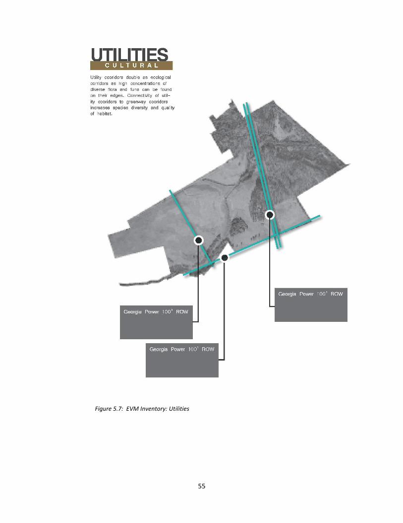
55
Figure 5.7: EVM Inventory: Utilities

56
Wind may also play a factor on safety of the site but probably more so for the health and
viability of the plants. Sensitive plants require a screen against high winds, and enhanced irrigation
needs to be considered because wind speeds up the evaporation of moisture in soil.
BIOLOGICAL INVENTORY
The biological inventory consists of a listing of vegetation found on the site, including location,
genus, species, and condition of all significant and edible trees and shrubs; the identification of wildlife
habitats, migration routes, and flyways, along with potential measures to preserve and protect them
and any existing environmental impact statements or other environmental quality reports produced for
the site, which should be carefully reviewed by appropriate project participants.
The southeastern vegetation for riparian ecosystems is diverse and determined by hydrologic
and soil conditions for bottomland ecosystems. Though much of the riparian areas along Grubbs Creek
within the property boundary have been cleared, a typical hardwood bottomland would return with
succession. Hardwood bottomlands includes forested wetland types such as red maple (Acer rubrum
var drummondii), Atlantic cedar bogs (Chamaecyparis thyoides), bald cypress (Taxodium distichum) and
tupelo (Nyssa aquatica and/or N. sylvatica var. biflora).
A large number of edible plants are currently found on the site. In many ways a food-producing
landscape already exists. Blackberries grow at the edges of utility easements. A lone apple trees stands
in the middle of the most easterly utility easement and sumac is found in the low lying areas along the
river’s riparian zone. Wheat grass and thatch, used as fodder for cattle, dominates much the cleared
pasture at East Village Monroe. Currently no signage exists to identify the edible plants in the landscape.
EVM is located within hydrologic unit (HUC) 8 of the Ocmulgee River, Upper watershed and
home to seven species federally protected, 32 state protected, 17 animals, 40 plants, and six natural
communities. A full list of known occurrences of special concern plants, animals and natural

57
communities Ocmulgee River, Upper Watershed – HUC8 Watershed Code: 03070103 can be found in
the appendix. Common Piedmont fauna represented in the area include gray fox, striped skunk, bear,
beaver, bobcat, raccoon, coyote, whitetail deer, eastern cottontail and squirrels (Georgia DNR).
The creeks found on the EVM site are located within the Alcovy River watershed. The Alcovy
River is a 292 square-mile (~187,000 ac) watershed located east of Atlanta, Georgia within the Upper
Ocmulgee Basin. The watershed spans four counties from its headwaters downstream to Lake Jackson,
and supplies water to surrounding areas from four drinking water intakes. The Alcovy River Watershed
Protection Project serves as a case study for a regional approach to watershed assessment and
management. Findings from the health assessment of the watershed and best practices for water
quality practices can be found at UGA’s River Basin Center website.
Each layer of information in the inventory is first studied in isolation for the East Village Monroe
site as a whole, to reveal distinct characteristics that could shape cultivation of food crops. Then the
layers are then combined to show interationships and an analysis is produced, including possible
opportunities or constraints on the site. Recommendations are then made for particular food
cultivation strategies appropriate to each area of the site.
CIRCULATION
A successful master plan takes advantage of both the site’s opportunities and constraints to
offer a unified, cohesive, and safe design. For the master plan at East Village Monroe the pedestrian
circulation network programs are represented on the plan as well as both the Community Development
Program and Food-Producing Landscape Program. These elements are then merged with the existing
community development plan from the site planner. The existing site plan indicates road layout,
community development program and food-producing landscape programs.

58
EVM will host a variety of thoroughfares to facilitate circulation for residents. As designed there
are four types of thoroughfares; vehicular, bike/cart path, sidewalk/foot path, and trail. The vehicular
roads are designed for vehicular and bicycle use with an average design speed of twenty-five miles per
hour. Bike and cart paths are dedicated routes limited to electric vehicles and bicycles. These routes
have a design speed of 10-15 miles per hour. Sidewalks and foot paths are hard surfaced, ADA accessible
routes for pedestrians only. Trail routes are not paved and are open to both pedestrians and carts and
bicycles.
Circulation Infrastructure:
Foot Path – hardscape surface 4-5’ wide
Bike/Cart Path – hardscape surface 7-8’ wide
Vehicular Routes – hardscape surface 22’-24’ wide (only crossing through greenway)
COMMUNITY DEVELOPMENT PROGRAM
Structures:
Information kiosk
Structure for Roadside Store/Market
Compost facility
Picnic areas
Food processing area
Barn
Community gathering place
Interpretive trail
Amphitheatre

59
FOOD – PRODUCING LANDSCAPE PROGRAM
The food-producing landscape program is a list of activities offered on the site:
Vineyards – berries, grapes, muscadine grapes
Orchards – peach, pear, apples, persimmons
Low-yield Annuals – cool season and warm season annuals. Operated with small tool equipment
High-yield Annuals – cool season and warm season annuals. Operated with heavy machine
equipment. Fodder and small animal husbandry which may include goats, pigs, chicken, and
bees may be used in these areas as well.
Community/Market Garden – mix of food-producing plants. Operated with small tool
equipment
Neighborhood Garden – mix of food-producing plants. Operated with small tool equipment

60
Figure 5.8: EVM Master Plan
MATRIX OF SAFETY CONSIDERATIONS FOR FOOD-PRODUCING LANDSCAPES
From the analysis of classifications posited in Chapter II the EVM project has been identified as a
peri-urban development and possesses the ability to produce food on both large scale and small scale.
Considerations rendered from a review of historical precedents and case studies in Chapter III and safety
protocols and legal summaries from Chapter IV fill the Matrix (see Table 5.1). The Matrix consists of
potential issues and considerations in three categories; design, mitigation, and operations. The
intersection of program element in conjunction with a food-producing landscape element is color coded
to indicate a rating from least concern to greater concern. The color code ranges from light orange to
dark orange, respectfully.

61
Table 5.1: Matrix of Safety Considerations in the food-producing landscape design at East Village Monroe

62
Each consideration then informs design as recommendations. These recommendations are
illustrated on the graphic vignettes. The recommendations adjust design intent rather than
prescriptively prohibit design as the case within most Euclidean zoning practices.
Figure 5.9: EVM Vignettes: High-yield production with foot & bike trail
Figure 5.10: EVM Vignettes: Orchard with food & bike trail

63
Figure 5.11: EVM Vignettes: Low-yield production with food & bike trail
As design professionals, understanding the risks and liabilities is paramount to protect those
encountering designed landscapes. Beyond the limits of the project at East Village Monroe, the
overarching goal of this study is to further research towards designing safe, integrated food-producing
landscapes in the built environment – physically safe for public participants and legally safe landscape
architects who design them.
To expand the potential effectiveness of the ‘Matrix’, an interesting exercise would be to deliver
food-producing landscape master plans to various stakeholders within the EVM project to reveal new
safety considerations outside of those documented in this thesis. Stakeholders can range in expertise –
from the wildlife ecologist to a pool maintenance mechanic – each one carrying a perspective that might
enhance the breadth of safety considerations and implications for food-producing landscape design.

64
Figure 5.12: EVM Vignettes: Vineyard with food & bike trail
65
CHAPTER VI
CONCLUSION
Reflecting on the story of the forbidden tree, McDonough uses this metaphor to illustrate a
culture of control, for the barriers erected and maintained – whether physical or ideological – between
nature and human industry. Yes, this thesis may push for yet another policy, yet another physical or
ideological barrier. However, if we are to move forward and continuously improve how we design and
construct the built environment we must carry lessons from the past and contend with unforeseen
challenges of the future, such as unknown climate change and ever-evolving human needs.
If the perceptions of lack of safety in the food-producing landscapes are preventing them from
being incorporated in our environment, as professionals, landscape architects need to break through
false perceptions with research and tools to argue for the inclusion of edibles in modern landscape
design in public spaces. A matrix for identifying safety considerations in food-producing landscapes is a
valuable tool to assist the safe integrated landscape design. Additionally, a matrix can be a vehicle for
multiple professions to identify possible conflicts and minimize risks for any design.
The need is increasing for professionals to expand the academic discourse of food-producing
landscapes as the global effort for sustainable development continues to grow. Cultivating policy to
enable edibles in public landscape design brings these goals closer. This thesis supports Thomas Lyson’s
notion that providing design policies and programs that support the development of fresh, local, organic
foods will foster a more viable system of production and consumption.
The 21st century brings unprecedented challenges for landscape architects to maneuver the
legal landscape of policies, rules, and regulations guarding public safety. Professional landscape

66
architects and clients they represent face a myriad of potentially damaging conditions when the public
interacts with their designed spaces. To protect and prepare themselves professional organizations like
the American Society of Landscape Architects have explicitly defined the roles and responsibilities of its
professionals. Unfortunately, many of the guidelines in the discipline have been shaped by lawsuits
brought against professional landscape architects and/or the owners they represent. The individual case
judgments have served to shape the professional landscape architect’s role and responsibility in
designing spaces for the public. Public policies pertaining to the regulation of urban agricultural provide
some resemblance of guidelines but fail to provide a tool for risk assessment.
For food-producing landscape design, rapid gains in popularity may signify its permanent place
in the fold of the landscape architecture profession. If this is true, the response of the professional
organizations of landscape architecture should be to educate landscape architects on the unique
nuances of food-producing landscape design to ensure physical safety of the public, and the legal safety
of landscape architect and the clients they represent.
This paper argues landscape architects fortified with tools like the ‘Matrix’ are equipped to
design safe, integrated food-producing landscapes. After all it’s about design; something landscape
architects know a great deal about. To a designer, a constraint is an opportunity. As designers in the
built environment, landscape architects are equipped with design power – the ability to communicate
universally through graphical communication, move water, shield the sun, shape the earth, and design
landscapes that grow food – safely.

67
APPENDIX
SEATTLE’S URBAN FARM BILL
In response to growing pressure to develop policy governing the demands for food-producing
landscapes the City of Seattle issued Bill and later adopted an ordinance that provides a public policy for
growing food in the city safely. In June of 2010, Seattle, Washington approved an ordinance to official
recognize “urban farms” and “community gardens” in all development zones, with some limited
opportunities in industrial zones (Coppersmith 2012, Council News Release). Included in Council Bill
116907 are requirements for establishing “urban farms” and “community gardens” within development
zones. The Bill furnishes mandatory provisions as to the mechanical equipment that can be used, times
of public sales, deliveries, signage, location in proximity within a site, and structures (23.42.051 Urban
Farms, Seattle Council Bill 116907). For “urban farms” that require an administrative conditional use,
meeting additional provisions of a management plan, submitting a “Potential impacts and Mitigation”
report, and an additional section of “Conditions of Approval” also applies for a permit. The “Potential
impacts and Mitigation report” must include impacts to water quality and soil, traffic and parking, visual
impacts and screening requirements, impacts to noise and odor, use of agricultural chemicals, and
impacts generated by mechanical equipment (SMC 23.42.051 Urban Farms).
The “Management Plan” for urban farms and community gardens must include a site plan,
description of equipment necessary, frequency and duration of use of equipment, disclosure of any
intent to spray chemicals or pesticides, frequency and duration of use of anticipated spraying, disclosure
of site land disturbance square footage, a proposed sediment and erosion control plan (23.42.051.1
Urban farms, Council Bill 116907). The “Potential Impacts and Mitigation” report includes impact reports
on the following; water quality and soil, traffic, visual impacts and screening, noise and odor, agricultural

68
chemicals, and mechanical equipment. The “Conditions of Approval” can customize some of the
aforementioned provisions, mostly to curb noise, odor, dust, and unsightliness. The Bill continues to
present provisions to “community gardens” and to “husbandry” as well, including limits and spatial
barriers on specific livestock.
Seattle’s aggressive support of the growing local food movement provides a valuable case study
as municipalities across the country look to explore provisions for keeping food-producing landscapes in
urban settings safe for consumers. The “Potential Impacts and Mitigation” report is an example of how
a municipality is guiding food-producing landscape design. Though a useful reference the report lacks
the ability to disseminate major risks from minor risk, which can be very helpful to the food-producing
landscape designer.

69
REFERENCES
Ackerman, Kubi, ed. The Potential For Urban Agriculture in New York City: Growing Capacity, Food
Security, & Green Infrastructure. N.p.:
n.d.Http://www.urbandesignlab.columbia.edu/sitefiles/file/urban_agriculture_nyc.pdf. Urban
Design Lab at the Earth Institute at Columbia University, 2012. Web. 2013
"Allotment (gardening)." Wikipedia. Wikimedia Foundation, 11 Jan. 2012. Web. 05 Nov. 2012.
<http://en.wikipedia.org/wiki/Allotment_(gardening)>.
Archer, Bruce, Ken Baynes, and Phil Roberts. A Framework for Design and Design Education: A Reader
Containing Papers from 1970s and 1980s. Rep. The Design and Technology Association, 2005.
"Beacon Food Forest." Seattle Parks and Recreation. City of Seattle, 13 Oct. 2011. Web. 07 Nov. 2012.
<http://www.seattle.gov/parks/projects/jefferson/food_forest.htm>.
Bellows, Anne C., Katherine Brown, and Jac Smit. Health Benefits of Urban
Agriculture. Www.foodsecurity.org. Community Food Security Coalition, 2003. Web. Mar. 2013.
"Beyond Pesticides." Home — Beyond Pesticides. Web. 25 Mar. 2013
<http://www.beyondpesticides.org/>
Boone, Christopher G., and Ali Modarres. City and Environment. Philadelphia: Temple UP, 2006. Print.

70
"Boston Urban Gardeners: Records, 1976-1989." Healey Library. UMASS Boston, n.d. Web. 05 Nov.
2012. <http://www.lib.umb.edu/node/1554>.
Brody, Jane E. "PERSONAL HEALTH; Taking the 'Wild' in Wildlife Seriously." The New York Times. The
New York Times, 06 July 2010. Web. 05 Nov. 2012.
<http://www.nytimes.com/2010/07/06/health/06brod.html?pagewanted=all>.
"Brownfields | US EPA." EPA. Environmental Protection Agency, 2013. Web. 25 Mar. 2013
Coppersmith, Megan. "Council News Release." Seattle City : Seattle City Council Approves Urban Farm
and Community Garden Legislation Improving Access to Locally Grown Food. City of Seattle, 16
Aug. 2010. Web. 07 Nov. 2012. <http://www.seattle.gov/council/newsdetail.asp?ID=10996>.
Corbett, Judy, and Michael N. Corbett. Designing Sustainable Communities: Learning from Village
Homes. Washington, D.C.: Island, 2000. Print.
Correll, D.L. 1997. Buffer Zones and Water Quality Protection: General Principles. Pages 7-20. In:
Haycock, N.E., T.P. Burt, K.W.T. Goulding and G. Pinay (eds.). Buffer Zones: Their processes and
potential in water protection. Proceedings of the International Conference on Buffer Zones,
September 1996. ISBN 09530051 0 0. Quest Environmental. Harpenden, Herfordshire, UK. 322
pages.

71
Czarnota, Mark, and Tim Murphy. "Georgia Center for Urban Agriculture." Georgia Center for Urban
Agriculture. University of Georgia, n.d. Web. 05 Nov. 2012.
<http://apps.caes.uga.edu/urbanag/Home&Garden/indexFS.cfm?storyid=2683>.
De la Salle 2010, Janine, and Mark Holland. Agricultural Urbanism: Handbook for Building Sustainable
Food Systems in 21st Century Cities. N.p.: Green Frigate, 2010. Print.
Duany, Andres. Garden Cities: Theory & Practice of Agrarian Urbanism. U.K.: Duany Plater Zybrek &,
2011. Print.
"Entomology: UGA Honey Bee Program: Bees, Beekeeping, and Pollination." Getting Started: Preparing
to Keep Bees. University of Georgia, n.d. Web. 05 Nov. 2012.
<http://www.ent.uga.edu/bees/get-started/preparation.html>.
Francis, Mark. User Needs and Conflicts in Urban Open Space: An Issue-based Case Study. Washington,
D.C.: Landscape Architecture Foundation, n.d. Print.
Francis, Mark. Village Homes: A Community by Design. Washington, DC: Island, 2003. Print.
Fujita, Masahisa, and Jacques-François Thisse. Economics of Agglomeration: Cities, Industrial Location,
and Regional Growth. Cambridge, UK: Cambridge UP, 2002. Print.

72
"Georgia DNR - Wildlife Resources Division." Georgia DNR - Wildlife Resources Division. Georgia
Department of Natural Resources, 2012. Web. 07 Nov. 2012.
<http://www.georgiawildlife.com/>.
Green, Jared. "The Edible City." The Dirt. American Society of Landscape Architecture, 30 Apr. 2012.
Web. 05 Nov. 2012. <http://dirt.asla.org/2012/04/30/the-edible-city/>.
Green, Jared. "Sustainable D.C. Food." American Society of Landscape Architects (ASLA) | Asla.org.
American Society of Landscape Architecture, n.d. Web. 05 Nov. 2012.
<http://www.asla.org/ContentDetail.aspx?id=33367>.
Green, Jared. "Urban Agriculture Isn't New." The Dirt. American Society of Landscape Architecture, 9
May 2012. Web. 05 Nov. 2012. <http://dirt.asla.org/2012/05/09/urban-agriculture-isnt-new/>.
Haeg, Fritz, and Diana Balmori. Edible Estates: Attack on the Front Lawn. New York: Metropolis, 2008.
Print.
Howard, Ebenezer. Garden Cities of To-morrow. Cambridge: MIT, 1965. Print.
Jackson, D. "Back to the Garden: A Suburban Dream." TIME 22 Feb. 1999: 78-79. Web.
Jackson, Wes, Wendell Berry, and Bruce Colman. Meeting the Expectations of the Land: Essays in
Sustainable Agriculture and Stewardship. San Francisco: North Point, 1984. Print.

73
"Knowledge and Skills/Tasks Required of Landscape Architects That Affect the Health, Safety, and
Welfare of the Public." Www.clarb.org. Council of Landscape Architectural Registration Board,
n.d. Web. 07 Nov. 2012. <https://www.clarb.org/Pages/default.aspx>.
Leschin-Hoar, Clare. "It's Not a Fairytale: Seattle to Build Nation's First Food Forest." News, Lifestyle, and
Social Action on TakePart. TakePart, LLC, 21 Feb. 2012. Web. 07 Nov. 2012.
<http://www.takepart.com/article/2012/02/21/its-not-fairytale-seattle-build-nations-first-food-
forest>.
Lofland, Lyn H. The Public Realm: Exploring the City's Quintessential Social Territory. Hawthorne, NY:
Aldine De Gruyter, 1998. Print.
Lovell, S. T. and D. M. Johnston. 2009. Designing landscapes for performance based on emerging
principles in landscape ecology. Ecology and Society 14(1): 44. [online] URL:
<http://www.ecologyandsociety.org/vol14/iss1/art44/>.
McDonough, William, and Michael Braungart. Cradle to Cradle: Remaking the Way We Make Things.
New York: North Point, 2002. Print.
Mollison, Bill, and Reny Mia. Slay. Permaculture: A Designers' Manual. Tyalgum, Australia: Tagari
Publications, 1988. Print.
Mougeot, Luc J. A. Growing Better Cities: Urban Agriculture for Sustainable Development. Ottawa:
International Development Research Centre, 2006. Print.

74
Mumford, Lewis. The City in History: Its Origins, Its Transformations, and Its Prospects. New York:
Harcourt, Brace & World, 1961. Print.
"Pesticides." EPA. Environmental Protection Agency, 2013. Web. 25 Mar. 2013.
Reiter, Beth. "Savannah City Plan." New Georgia Encyclopedia: Savannah City Plan. Georgia Humanities
Council and the University of Georgia Press, 23 Jan. 2004. Web. 05 Nov. 2012.
<http://www.georgiaencyclopedia.org/nge/Article.jsp?id=h-2547>.
Rideout, Karen. "Urban Agriculture: Issues for Public and Environmental Health." Urban Agriculture:
Issues for Public and Environmental Health. National Collabrating Centre for Public Health, 22
Jan. 2010. Web. 05 Nov. 2012. <http://www.slideshare.net/NCCEnvHealth/urban-agriculture-
issues-for-public-and-environmental-health>.
Schaffer, Daniel. Garden Cities for America: The Radburn Experience. Philadelphia: Temple UP, 1982.
Print.
Schatz 2003, Alex P., J.D. Regulation of Landscape Architecture and the Protection of Public Health,
Safety, and Welfare. Rep. American Society of Landscape Architecture, Oct. 2003. Web. Nov.
2012.
<http://www.asla.org/uploadedFiles/CMS/Government_Affairs/Member_Advocacy_Tools/PHS
W-FINAL.pdf>.

75
Seattle City Council Bill: 116907, Ordinance: 123378. August 16, 2010.
Http://clerk.ci.seattle.wa.us/~archives/Ordinances/Ord_123378.pdf (2010) (enacted). Print.
Thayer, Robert L., Jr. "The Experience of Sustainable Landscapes." Landscape Journal 8.2 (1989): 101-10.
Galileo. Web. Oct. 2012. <http://http://lj.uwpress.org/content/8/2/101.abstract>.
Thayer, Sam. "Sumac: The Wild Lemonade Berry." Sumac: The Wild Lemonade Berry by Sam Thayer from
the July/August, 2003 Issue of Countryside & Small Stock Journal. Countryside Magazine, n.d.
Web. 05 Nov. 2012. <http://www.countrysidemag.com/issues/87/87-4/Sam_Thayer.html>.
Thompson, Ian H. The Sun King's Garden: Louis XIV, Andre Le Nôtre, and the Creation of the Gardens of
Versailles. New York: Bloomsbury, 2006. Print.
"URBAN AND PERI-URBAN AGRICULTURE." FAO. Food & Agriculture Organization of the United Nations,
n.d. Web. 05 Nov. 2012. <http://www.fao.org/unfao/bodies/COag/cOAG15/X0076e.htm>.
Viljoen, André, Katrin Bohn, and J. Howe. Continuous Productive Urban Landscapes: Designing Urban
Agriculture for Sustainable Cities. Oxford: Architectural, 2005. Print.
"Welcome." Letchworth Garden City Heritage Foundation. Letchworth Garden City Heritage Foundation,
2012. Web. 07 Nov. 2012. <http://www.letchworth.com/heritage-foundation>.