Embed Size (px)
Citation preview

CFOCUS GROUP MEETINGS


LIST OF INVITED PARTICIPANTS: FOCUS GROUPS | JANUARY 2015
Name Affiliation
Farmers and producers
Brian Miyamoto Hawaii Farm Bureau Federation
Mark Suiso Makaha Mangoes, Hawaii Tropical Fruit Growers
Wayne Ogasawara Mililani Agricultural Park
Mama T. Trisha Gonsalves Hawaii Organic Farmers Association, Down to Earth
Clifford Migita Waimanalo Agricultural Assn.
Pamela Boyar Hawai‘i Farmers Union United
Alec Sou Aloun Farms
Bud Gibson Rocker G Livestock Co (Waimanalo)
Melissa Zemen Kunia Agricultural Park
Agricultural support and related industries
Pauline Sato Agricultural Leadership Program
Jean Brokish Oahu RC&D Council
Dave Ringuette Windward Community College, GOFarm Hawai‘i Program
Jensen Ueda UH‐CTAHR Extension Agent
Nathan Miranda Windward Oahu Soil and Water Cons. District
Wholesalers and consumers
Claire Sullivan Whole Foods , Purchasing/Public Affairs
Russell Hata Y. Hata
Kacey Robello Hawaii Farm Bureau Federation, Farmers Market Manager
Kevin Vacarello Sustain Hawaii, also Sweet Home Waimanalo
Tish Uyehara Armstrong Produce, Agribusiness Development Corporation
Environmental Interests
Steve Montgomery Sierra Club
Tim Vandeveer Defend Oahu Coalition
Sam Gon Nature Conservancy
Stephen Rafferty Trust for Public Land
Marti Townsend Outdoor Circle
Kioni Dudley Friends of Makakilo
Community Organizations and Neighborhood Boards
Ted Radovich UH‐CTAHR Organic Farming, Waimanalo N.B.
Jeanne Ishikawa, Chair Wahiawa N.B.
Antya Miller North Shore N.B.
Cynthia Rezentes Nanakuli‐Maili N.B, Chair
Johnnie‐Mae Perry, Chair Waianae Coast N.B.
Kent Fonoimoana Koolau Loa N.B.
Amy Leursen Kahaluu NB
Landowners John Morgan Koolau Ranch
James Nakatani Agribusiness Development Corporation
Bev Kaku Castle and Cooke
Steve Hoag Hawaii Reserves Inc.
Sidney Keliipuleole Kamehameha Schools
Native Hawaiian Interests
Jeannin Jeremiah Office of Hawaiian Affairs
Michele Wilhelm Kapalai Farms
Nick Reppun Kakoo Oiwi
Rick Barboza Hui Ku Maoli Ola
Trevor Atkins Halau Ku Mana Charter School
Puni Freitas Kokua Kalihi Valley
Government Agencies
Sen. Russell Rudermann Senate AG Committee Chair
Rep. Clift Tsuji House AG Committee Chair
Russell Tsuji DLNR Land Division


Pacific Guardian Center │ 733 Bishop Street, Makai Tower Suite 2590 │ Honolulu, Hawai‘i 96813
Date: December 24, 2014
To: Tim Hata, IAL Project Manager Department of Planning and Permitting
From: Corlyn Orr / Scott Ezer
RE: Proposed Focus Group Members
This memorandum presents the roster of participants to be invited to the three focus group meetings (Project Scope of Work, Item C.2). This roster reflects input from TAC members, as well as consultations with DPP and the subconsultant team. Using the eight categories of agricultural interests identified during discussions with the TAC, the ideal number of participants allotted for each focus group is sixteen (see table below).
Distribution Of Focus Group Participants By Category Category Number allotted
per focus group Farmers/producers 3 Ag support and related industry 2 Wholesalers/consumers 2 Environmental interests 2 Community organizations/NBs 2 Landowners 2 Native Hawaiian Interests 2 Government Agencies 1 PARTICIPANTS PER FOCUS GROUP 16
The process to develop the roster is summarized as follows:
1. Prepare a preliminary list of focus group candidates (31 names were presented at TAC Meeting #1)
2. Seek input from TAC members for suggestions of candidates/organizations (an additional 42 candidates were identified during TAC Meeting #1)
3. Review the candidate list with DPP and the subconsultant team (a total of 80 candidates were discussed on December 19, 2014)
4. Arrange candidates into focus groups, taking into consideration the number of interests allotted to each category and each candidates’ affiliation and geographic area represented.
We are in the process of compiling contact information, and plan to call and invite focus group participants in January 2015.
MEMORANDUM

Focus Group 1 Focus Group 2 Focus Group 3 Alternates
Farmers and producers
1. Mark Fergusson, Hawaii Organic Farming Assn.
Wayne Ogasawara, Mililani Agricultural Park
Bud Gibson, T&C Stables (Waimanalo)
1. Lee Bryant, May's Wonder Gardens, North Shore N.B. AG Committee
2. Susan Matsushima, Alluvion, North Shore Econ. Vitality Partnership Co‐
3. Melissa Zeman, Kunia Agricultural Park 4. Gary Maunakea Forth, MAO Farms 5. Fat Law, Fat Law's Farm HI
2. Brian Miyamoto, Hawaii Farm Bureau Federation
Alex Sou, Aloun Farms Sharon Peterson Cheape, Petersons Upland Farm
3. Mark Suiso, Hawaii Tropical Fruit Growers
Clifford Nigita, Waimanalo Farmers Association
Clifford Wong, Haleiwa luau leaf farmer
Ag support and related industry
4. Pauline Sato, Agricultural Leadership Program
Kapua Sproat Fonoimoana, Windward O‘ahu Soil and Water Cons. District
Dave Ringuette, WCC Agriculture Dept, GOFarm Hawai‘i Program
1. Ted Tokunaga, Farm Credit Services 2. Stan Kodama, Waimanalo Feed Store 3. Jason Shitanishi, USDA Farm Service
Agency, Farm Programs 4. Brian Kau, DOA AG Research
Management Division
5. Jean Brokerish, Oahu RC&D Council
Jary Sugano, UH‐CTAHR Extension Agent
Ron Kauhaahaa, Crop Protection Services (pesticides)
Wholesalers and consumers
6. Kevin Vacarello, Sustain HI, Sweet Home Waimanalo
Conrad Nonaka, Culinary Institute of the Pacific
Ed Kenney, TOWN Restaurant
1. Mark Noguchi, The Pili Group, Mission Restaurant
7. Russell Hata, Y. Hata
Claire Sullivan, Whole Foods
Tish Uyehara, Armstrong Produce
Environmental interests
8. Deborah Ward, Sierra Club, AG/Conservation Comm.
Sam Gon, Nature Conservancy
Alexandria Avery, Outdoor Circle president
1. Doug Cole, N.S. Community Land Trust 2. Kyle Datta, Ulupono
9. Tim Vandeveer, Defend O‘ahu Coalition
Lea Hong, Trust for Public Land
Kioni Dudley, Friends of Makakilo
Community organizations and NBs
10. Ted Radovich, UH‐CTAHR Organic Farming, Waimanalo N.B.
Waianae Coast N.B. Cynthia Rezentes, Nanakuli‐Maili N.B.
1. Amy Leursen, Kahaluu N.B.
11. Wahiawa N.B. Antya Miller, North Shore N.B.
Koolau Loa N.B.
Landowners 12. John Morgan, Koolau Ranch
Carlton Ching, Castle and Cooke
Sidney Keliipuleole, Kamehameha Schools
13. James Nakatani, Agribusiness Dev. Corp.
Eric Beaver, Hawaii Reserves Inc.
Neighborhood Board Rep.
Native Hawaiian Interests
14. Office of Hawaiian Affairs Kanekoa Kukea‐Shultz, Kakoo Oiwi
Trevor Atkins, Halau Ku Mana Charter School
15. Dean Wilhelm, Kapalai Farms
Rick Barboza, Hui Ku Maoli Ola
Makahiapo Cashman, UH Ka Papa Loi o Kanewai
Government Agencies
16. Sen. Russell Rudermann, Senate AG Comm. Chair
Rep. Clift Tsuji, House AG Comm. Chair
Russell Tsuji, DLNR Land Division

OTHER ALTERNATES
FARMERS/PRODUCERS
1. Pam Boyer, Hawaii Farmers Union United
2. Mike Buck, Waimanalo farmer/CWRM Board
3. Mel Matsuda, Kahuku Farms
4. Ron Wiedenbach, HI Fish Co., HI Aquaponics Aquaculture Association
5. Eric Enos, Kaala Farms
6. Greg Smith, Gunstock Ranch
7. Larry Jefts, Sugarland Farms, West Oʻahu Soil & Water Conservation District Chair
AG SUPPORT AND RELATED INDUSTRIES
8. Lisa Zemen, South Oʻahu Soil & Water Conservation District, Chair
9. Matthew Loke, UH‐CTAHR Sustainability
10. Gordon Ogi, American Machinery
11. Bernadette Luncsford, USDA NRCS Field Office, District Conservationist
12. Susan Kubo, USDA NRCS Field Office, Civil Engineer
WHOLESALERS/CONSUMERS
13. Kacey Robello, HI Farm Bureau, Farmers' Market GM
14. Alan Wong, Alan Wong's Restaurants
ENVIRONMENTAL INTERESTS
15. Murray Clay, Ulupono
16. Donna Wong, Hawaii's Thousand Friends, Kailua Neighborhood Board
NATIVE HAWAIIAN INTERESTS
17. Kihei Nahale'a, Papahana Kuaola
18. Puni Freitas, Kokua Kalihi Valley
GOVERNMENT AGENCIES
19. Jackie Kozal Thiel, Governor’ Sustainability Coordinator


Pacific Guardian Center 733 Bishop Street, Makai Tower Suite 2590 Honolulu, Hawai‘i 96813
MEETING SUMMARY
Date: January 22, 2015 HHF Project No. 2014120
Time: 4:30 6:20 pm Project Name: O‘ahu IAL Mapping Project
Location: Pacific Guardian CenterMakai Tower Conference Room
Recorded by: Corlyn OrrReviewed by DPP: Feb. 12, 2015
Attendees: see attendance record
Subject: Small Group Discussion #1
The first of three small group discussions for the City’s Important Agricultural Lands (IAL) Mapping Projectwas held on Thursday, January 22, 2015 at the Pacific Guardian Center, Makai Tower Conference Room(733 Bishop Street, Honolulu). The meeting was scheduled from 4:30 to 6:30 pm. The purpose of themeeting was to provide an overview of the project and allow for group discussion. Fifteen invitedattendees were present (see attached attendance record). Meeting materials emailed to participants inadvance of the meeting included a meeting agenda, project sheet, unofficial copy of Chapter 205 Hawai‘iRevised Statutes (HRS), and an electronic link to the IAL Phase I Report. Hard copy of the PowerPointpresentation was passed out at the meeting.
WELCOME, INTRODUCTIONS, AND PROJECT BRIEFING
Scott Ezer opened the meeting at roughly 4:35 pm with introductions of the project team. KathySokugawa, DPP Planning Division Chief, followed with opening remarks. On behalf of DPP, Kathy thankedeveryone for participating and emphasized the City’s desire for a meaningful, efficient and transparentprocess. Following individual introductions, Peter Adler (meeting facilitator) summarized the goals forthe meeting: (1) brief attendees on work done to date (2) gather comments and concerns for DPPconsideration, and (3) prepare for the community meetings. Scott then reviewed the legislative historyand statutory requirements for the IAL designation, the preliminary criteria maps, and the proposedcommunity outreach process (see attached PowerPoint).
GROUP DISCUSSION
After Scott completed the presentation, Peter asked if there were any questions for information and/orclarification. Questions and responses are summarized as follows.
Will this project have any influence on developing future AG policies for the City, or is this projectlimited to discussing the designation of AG lands? What is the link between this project andlarger AG policies?
o Although the project will focus on identifying land for IAL designation, the county is alsorequired to address the IAL incentives. Other policy related items discussed during thecommunity outreach process will be documented in the final report.
O‘ahu IAL Mapping ProjectSmall Group Discussion 1 | January 22, 2015Page 2 of 5
Are there any landowners on O‘ahu that have already designated 50% of their land IAL and willbe exempted from this process?
o No.
Why are State owned lands not being considered?o According to State law, the State DOA and DLNR are responsible for mapping IAL for
State owned land.
Why would the State need to designate their lands as IAL? If one purpose for IAL is to qualify forincentives, what is the benefit of the IAL designation for the State?
o This is a question for the State.
Areas excluded from the study area were clarified:(1) Areas south of Wahiawa and Mililani are federally owned or in the State Urban District(2) Kahalu‘u, K ne‘ohe and Kailua are in the State Urban District
Peter then asked a series of questions. A summary of the questions and discussion is provided below.
QUESTION: Imagine the future of O‘ahu’s agricultural lands. What lands do you “see” 20, 30, 50 yearsout? Assuming that production methods and the types of crops grown will change, what will thefootprint of O‘ahu’s agricultural land look like? How is the land base going to change?
Urban agriculture will multiply, with gardens in residences and food crops growing in Honolulu’soffice towers and high rise residential buildings. Agriculture will be integrated into urban living,the footprint will be larger, and the boundaries between urban and agriculture will blur together.
Lands that are currently fallow and still transitioning from sugar and pineapple production, suchas the Galbraith lands, will be in use. The large chunks of agricultural land will be retained, andbe in active production. Landowners are waiting to see what happens. Hopefully, options willlead to AG as the best use, and lands will not be fallow. For example, Kamehameha Schools isdiligent about implementing their agricultural plan, which would leave a large agriculturalfootprint on the North Shore.
Larger land parcels will be divided into smaller pieces. This will depend on tax fees andownership structures.
Different types of crops will be grown, with different reasons for growing. For example, algae isbeing grown for energy in Wahiawa on fallow land.
The agricultural footprint will be concentrated around Central O‘ahu. These lands have all theelements needed for growing (e.g., soil, sunlight, water). The next step is to see who’s going touse the larger chunks of land and promote agriculture. The land will stay in agriculture as long asthe infrastructure needed for residential development is not built. There had been a proposal tobuild housing on the Galbraith lands, but there is no infrastructure to support development.Aquaponics, home gardens and other strategies will encourage self sufficiency, but such effortswill supplement production coming from the largest chunks of land. No matter how much isproduced on other islands, O‘ahu will always have a market/locational advantage over theneighbor islands.
QUESTION: What data and information is missing that needs to be considered in this process? What wasnot considered by the TAC that needs to be considered?

O‘ahu IAL Mapping ProjectSmall Group Discussion 1 | January 22, 2015Page 3 of 5
The water criteria map (Criterion #5 map) should identify lands that have access to R 2 recycledwater because water from the Wahiawa Wastewater Treatment Plant/Wahiawa Reservoir usedfor irrigation purposes has been upgraded to R 2. Scott clarified that lands irrigated by recycledwater are included in the Criterion #5 map, without specifically calling out the type or quality ofirrigation water. There was general agreement that this should be highlighted in futureconversations.
How much of the community outreach process will focus on educating the public about theintent of the legislature? It is important that the general public understand thebackground/history and purpose of the IAL legislation. Considering that it will be difficult toconvey all of this information through the community meetings, the website should be used asan information sharing tool. UH Law School (2nd year seminar project) prepared an analysis ofthe legislation that may be a useful resource to include on the website.
QUESTION: There will be two general types of questions: (1) from people with agricultural expertise andexperience farming; and (2) from members of the general public without agricultural experience. Whatare the hard questions that will be asked in this process?
Why is the Ho‘opili project area excluded from this process? How was the TAC selected? The TAC recommendations may be questioned because of the
committee composition. What is IAL? The general public may have basic questions about the basic definition and concept
of IAL. Budgetary constraints should not be a limiting factor for education and outreach. How can farmers access the lands identified as IAL? How does IAL benefit small farmers? How will IAL affect the community? What about the social, economic and environmental
implications for surrounding communities? Agricultural communities in Wahiawa (e.g.,Whitmore, Kunia) have expressed a desire for agricultural jobs and the ability to retain their rurallifestyles.
What is the status of the incentives? Being able to speak with more certainty about theincentives may help to convey the potential benefits of the IAL designation.
Possible questions may concern housing:o What is the impact to affordable housing? (Some will feel that affordable housing is more
important than preserving agricultural land.)o Where are agricultural workers going to live? The long range plan needs to include farm
worker housing. How will the IAL designation affect land use? What can a landowner no longer do with their land
if their property is designated IAL? Is it possible to consider lands currently occupied by the military? This would provide a back up
plan for the possibility that the military reduce their footprint and vacate their lands (e.g.,Lualualei, Makua Valley, Schofield). Scott indicated that the law requires the counties to conductperiodic reviews of the IAL maps, and that any excess military lands are automatically placed inthe P 2 Preservation zoning district.
What are the implications of the IAL designation for gentleman estates? How will this discouragegentlemen estates?
How much is this initiative going to cost the taxpayers? What are the costs of IAL? A loss inpotential taxes is possible. However, this would result from the cost of paying for any incentives,not from the loss of property tax revenues (assuming that these lands are currently in agricultural
O‘ahu IAL Mapping ProjectSmall Group Discussion 1 | January 22, 2015Page 4 of 5
use and the tax structure stays the same). It may be possible that the economic and employmentbenefits from increasing agricultural production may outweigh the costs.
Would IAL include flower crops? Scott clarified that IAL is not specific to food crops. The use ofthe land for agricultural production is important, not the type of crop grown (flowers,landscaping, turf growing are also included).
During the discussion, it was emphasized that the IAL designation is a land use regulatory/zoningmechanism that does not impose any restrictions on the use of the land, does not require that the landbe farmed, and will not resolve other agricultural issues. IAL will provide a hierarchy within the State’sAgricultural District to ensure that the most valuable agricultural lands are protected. Speculation tourbanize agricultural lands should disappear once lands are designated IAL, since it is more difficult tourbanize land that has an IAL designation. (For clarification, Chapter 205 50(f), HRS requires a 2/3 vote ofthe Land Use Commission or the county’s decision making body when reclassifying or rezoning landsfrom IAL. The legislature does not have jurisdiction to reclassify IAL.) Without the prospect ofurbanization overshadowing these lands, large landowners may be more willing to make a long termcommitment to agriculture and offer small farmers long term leases.
QUESTION: What are the difficult trade offs of the IAL designation? What is at stake to be lost? Landowners whose lands are designated involuntarily under the county process may have a
sense of lost opportunity costs. The ability to reclassify lands that have been designated as IAL will get more difficult.
Landbanking (waiting for future development opportunities) should no longer be an issue, asthere will be clarity about which lands are to be preserved for agricultural use.
A possible gain may be an increase in the number of people interested in agriculture. Out ofstate entrepreneurs may be attracted to O‘ahu to invest in new agricultural enterprises. Smalland P/T farmers may find new opportunities to farm.
QUESTION: How would you address traditional native Hawaiian agricultural uses and unique crops(Criterion #4)? Are there other considerations that were not addressed?
The type of crop grown is not as important as the economics. Farmers will grow certain crops ifthey can make money. If it is not commercially viable for the farmer, farming may still berelevant as a hobby.
The map of Criterion #4 needs to identify historic/iconic lands used for kalo because the culturalsignificance of these areas is important. .
QUESTION: What are your thoughts about the proposed community outreach process? Do you have anyadvice or ideas for how to talk to a wider range of people?
Ground rules are critical. Control the discussion, do not allow for redundancy, and limit the timegiven for individual comments. Keep the discussion focused, restate the meeting purpose often.
Post a visual reminder of the meeting purpose and refer to it often. Be prepared to entertain the non farming public and those with other agendas. None of the meeting attendees were involved with Kauai County’s IAL project.
QUESTION: Are there any other issues, ideas or concerns to be considered? Is there any overlap between the City’s IAL project and the Trust for Public Land’s GreenPrint
project? Are the two projects sharing information? The general public may express someconfusion and fatigue, since both projects involve mapping.
O‘ahu IAL Mapping ProjectSmall Group Discussion 1 | January 22, 2015Page 5 of 5
Engage the membership of both the Hawai‘i Farm Bureau and the Hawai‘i Farmers Union. A report from landowners who achieved IAL status would be helpful to understand the positive
and negative consequences of IAL (e.g., case studies showing improved conditions such as landsin production, long term leases, infrastructure investments, etc.)
The motivation for the IAL designation is different for each landowner. Castle and Cooke soughtthe IAL designation to access the incentives because making agriculture more economically viablewas important to them. Kamehameha Schools is seeking the IAL designation to demonstratetheir long term commitment to agriculture.
Landowners are interested in knowing what incentives are already available, and when countyincentives will be available. Incentives for employee housing, infrastructure improvements, andother types of investments to make farming more affordable are needed now.
Peter thanked everyone for attending, asked them to complete a brief questionnaire, and then closed themeeting. Meeting was adjourned at about 6:20.
ATTENDANCE RECORD
Invited Participants: Jean Brokish, Oahu Resource Conservation & Development Council (via Facetime)Ian Hirokawa, DLNR Land DivisionJeanne Ishikawa, Wahiaw Neighborhood Board #26Brian Miyamoto, Hawai‘i Farm Bureau FederationSteve Montgomery, Sierra ClubJohn Morgan, Kualoa RanchJames Nakatani, Agribusiness Development Corp.Wayne Ogasawara, Mililani Agricultural Park/Agricultural landownerSenator Russell Ruderman, State Senate AG Committee ChairPauline Sato, Agricultural Leadership FoundationMark Suiso, Hawai‘i Tropical Fruit GrowersClaire Sullivan, Whole FoodsRussell Tsuji, DLNR Land DivisionTim Vandeveer, Defend O‘ahu CoalitionMichele Wilhelm, Kapalai Farms
Others: Randy Hara, DPPKathy Sokugawa, DPP Planning Division HeadDr. Po Yung Lai, City’s AG LiasionScott Ezer, HHF PlannersErin Higa, HHF PlannersRob James, HHF PlannersCorlyn Orr, HHF PlannersPeter Adler, ACCORD3.0 NetworkBruce Plasch, Plasch Econ Pacific

Pacific Guardian Center 733 Bishop Street, Makai Tower Suite 2590 Honolulu, Hawai‘i 96813
Date: January 28, 2015 HHF Project No. 2014120
Time: 4:30 6:30 pm Project Name: O‘ahu IAL Phase 2
Location: Pacific Guardian CenterMakai Tower Conference Room
Recorded by: Corlyn OrrReviewed by DPP: February 17, 2015
Attendees: see attendance record
Subject: Small Group Discussion #2
The second of three small group discussions for the City’s Important Agricultural Lands (IAL) MappingProject was held on Wednesday, January 28, 2015 at the Pacific Guardian Center, Makai TowerConference Room (733 Bishop Street, Honolulu). The meeting was scheduled from 4:30 to 6:30 pm. Thepurpose of the meeting was to provide an overview of the project and seek feedback from the group.Ten invited attendees were present (see attached attendance record). Meeting materials emailed toparticipants in advance of the meeting included a meeting agenda, project sheet, unofficial copy ofChapter 205 Hawai‘i Revised Statutes (HRS), and an electronic link to the IAL Phase I Report. Hard copyof the PowerPoint presentation was passed out at the meeting.
WELCOME, INTRODUCTIONS, AND PROJECT BRIEFING
Scott Ezer opened the meeting at roughly 4:35 pm with introductions of the project team. Followingindividual introductions, Peter Adler (meeting facilitator) summarized the goals for the meeting: (1) briefattendees on work done to date; (2) gather comments and concerns for DPP consideration; and (3)prepare for the community meetings. Kathy Sokugawa, DPP Planning Division Chief, followed withopening remarks, which included thanking everyone for participating and highlighting the City’s goal ofpreparing the IAL maps with as much community participation as possible. Scott then reviewed thelegislative history and statutory requirements for the IAL designation, the preliminary criteria maps, andthe proposed community outreach process (see attached PowerPoint).
After Scott completed the briefing, Peter asked if there were any questions for additional informationand/or clarification. Questions and responses are summarized as follows.
State owned lands in Central O‘ahu (i.e., former Galbraith Estate lands) have not beendesignated IAL.
o State owned lands were excluded from County consideration as provided in Chapter205, HRS.
Recycled water is accounted for in the map identifying lands with adequate water (Criterion #5).There should be a distinction between high quality water and recycled R 2 water. The NorthShore does not have an adequate water supply because the use of R 2 recycled water fromWahiawa Reservoir limits the types of crops that can be grown.
MEETING SUMMARY
O‘ahu IAL Mapping ProjectSmall Group Discussion 2 | January 28, 2015Page 2 of 6
o Response indicated that the process was blind to creating hierarchy for preferred crops.R 2 water is capable of supporting agricultural irrigation, but not directly on leafy foodplants.
How did you choose farmers for the Technical Advisory Committee?o Recommendations from different sources—including the City’s agricultural liaison,
individuals familiar with the AG industry, and DPP—were considered. Chapter 205, HRSalso mandates the involvement of certain organizations (e.g., Hawai‘i Farmers Bureau,State Office of Planning, Dept. of Agriculture, Commission of Water ResourcesManagement). The goal was to involve a diverse cross section of farming interests, suchas small and large farmers, food producers, ranchers, nursery crops, landscapers, flowergrowers, etc.
How easy will it be to modify or change the IAL designation? How firm will the boundaries be?The concern is that the City will not utilize the IAL classification to provide long range guidancefor future land use decisions, and that landowners will be able to modify the IAL classification likethe DPs/SCPs and zoning can be changed.
o The LUC is the authorizing body with jurisdiction to designate land IAL and change the IALdesignation. It will be difficult to redesignate IAL, since it requires a two thirds vote ofthe LUC (requiring 6 3 votes, as opposed to the standard 5 4 votes). Once the inventoryof IAL is identified, DPP is hopeful that the regulatory mechanisms that promoteagricultural use of the land will follow. An anticipated benefit of IAL is that it willdiscourage speculative land banking practices associated with short term farming leaseswhile landowners wait to develop the land for housing.
How will the IAL designation affect agricultural land subdivisions? Will it still be possible tosubdivide agricultural land into two acre parcels and create gentlemen estates?
o The intent of this project is to identify the baseline of important agricultural lands, anddistinguish between the important lands and the lesser quality agricultural lands. This isa discreet project to identify the land base that needs to be preserved and to answer thequestion about where agriculture should be on O‘ahu. This will not resolve all existingagricultural issues, although it should ultimately result in future regulatory mechanismsto better manage the use of lands identified as IAL.
Is there a mechanism to add additional IAL to the inventory in the future?o Yes, the law requires the counties to periodically review the IAL inventory. This is an
important process because the face of agriculture is constantly changing. (Consider howmuch has changed in the past 30 years). Private landowners are also able to petition theLUC on their own. For example, Kamehameha Schools has filed an individual petitionwith the LUC to designate about 10,000 acres of their North Shore lands.
Can the criteria maps be revised to remove the Urban Boundary filter? It would be interesting tosee the qualities of all the land areas, especially since much of Windward O‘ahu lands that arecurrently in agriculture are excluded from the map.
o Areas excluded from mapping are in the State Urban District or designated for urban useby the county, as prescribed by state law. Several areas currently in agricultural use were

O‘ahu IAL Mapping ProjectSmall Group Discussion 2 | January 28, 2015Page 3 of 6
excluded from the study area because they are in the State Urban District; a largeacreage in Kahalu‘u was planned for urban/industrial development in the 1960s, and is inthe State Urban District. Based on the current law, the State land use classificationwould have to be changed for land to be eligible for IAL under the county designationprocess.
Including military lands in the process will be a concern. Lualualei and M kua were active andproductive agricultural areas before military occupation, and these areas represent largeacreages that could be available for future agriculture, should the military decide to vacate.
What is the timeframe for the next steps in the process?o The community meetings are tentatively targeted for April, followed by a written public
comment period, and a second round of community meetings tentatively anticipated forFall 2015. The goal is to complete the project within a year from now.
Peter then asked a series of questions. A summary of the questions and discussion is provided below.
QUESTION: Imagine the future of O‘ahu’s agricultural lands. Thinking broadly across the agriculturalindustry, what lands do you “see” two to three generations out? Even if production methods or the formor types of crops grown changes, what is needed for a good agricultural base on this island?
Hawai‘i Organic Farmers Association sees a substantial portion used for organic, sustainablefarming to grow food to serve the island community. Even the farmers on the TAC are growingcorn seed and crops for export, and not serving the needs of the island. We need a lot of land forfarming. It’s also profitable to support local agriculture because it creates jobs, and the moneycirculates in the local economy. Knowing what is being farmed on the lands designated IALwould be interesting.
If the goal is self sufficiency and sustainability, then the City should protect as much land aspossible. Even if the industry is comprised solely of small organic farms (no large scaleagriculture) and all farmers are growing edible crops, we still won’t be able to grow enough foodto sustain the current population, or the population 20 50 years from now. The county shoulduse as many criteria as possible to designate as much land as possible. The additional 20,000acres gained by using all the criteria is significant.
Was ranching mapped in the top 3 criteria? Lands suitable for ranching may not meet the top 3criteria. Is it necessary to add another criteria to specifically identify potential ranching land?Grazing lands are typically not high quality agricultural lands used to grow food; they are typicallyfound at higher elevations, without good soils and irrigation, and are not productive farmland.
o For clarification, ranching was mapped as part of Criterion #1: Current AG Production.
Was forestry included as current production?o No, most forestry activities on Oahu are in the State Conservation District, not the
Agricultural District and the review precluded lands in the Conservation District, perChapter 205, HRS. [Note: On the NIs, commercial forests are located within the AgDistrict.]
O‘ahu IAL Mapping ProjectSmall Group Discussion 2 | January 28, 2015Page 4 of 6
The fear is that there will be lots of land for farming, but nobody to farm the land. It’s not easy tobe a farmer, it’s even harder to be an organic farmer. We may lose farmers because the costs ofproduction and food safety regulations are overly taxing, and it is hard to make money farming.
The incentives are aimed at helping both landowners and farmers. Small immigrant farmers areonly successful because the entire family works the farm. These farmers would especially benefitfrom incentives. Farmers would also benefit from longer term leases, which would then helpthem qualify for loans.
The quality of the soil is important for the overall success of agriculture. In this regard, incentivesshould encourage farmers to improve the health of the soil. This would provide for pestmanagement, ensure that the soil has the proper nutrients to grow food, and also promotesustainable/organic farming. Promoting soil quality ensures that the land qualifies as IAL later.
Climate change impacts, including sea level rise and changes in the water table, need to beconsidered for future generations. Taking into account sea level rise and the loss of coastalareas, the goal should be to maximize as much IAL as possible.
QUESTION: What would you do to balance the different factors involved in designating IAL? How wouldyou balance the criteria? Are the top 3 criteria equal, or is there a balancing act to prioritize the criteria?
The goal should be to designate as much land as possible. Make the boundaries as big aspossible in case they shrink later.
The process should identify future opportunities for lands that don’t currently qualify for the IALdesignation. People would benefit from a mechanism that identifies the limitations of thecriteria and describes what might be necessary to add additional acreage to the inventory.
QUESTION: What are your thoughts about the proposed community outreach process? Do you have anyadvice or ideas for how to talk to a wider range of people? How would you structure the presentation?
Make sure people are clear about what can be changed as a result of the community input.Ensure that people understand that their comments were received and considered; that theinformation and comments received through the community outreach process will besynthesized and presented to DPP for decision making.
It is inevitable that some groups will be upset that they were not invited to participate in thepreliminary discussions to define and operationalize the criteria. Agriculture is a passion formany individuals, and people will bring their personal agendas and will want to discuss peripheralissues. Use storyboards; the presentation is overly long and technical. Be clear about theprocess and the constraints of the law. Start with the lands included in the study (i.e., state thatmilitary lands are not part of the discussion, identify lands not included in the study, and citeState law), explain what is covered by each criterion, be clear about what can be discussed (i.e.,focus on mapping), and what’s not open for discussion (i.e., not discussing GMO or pesticides).

O‘ahu IAL Mapping ProjectSmall Group Discussion 2 | January 28, 2015Page 5 of 6
People will want to know up front which lands are priority (i.e., start with recommendations andback into the supporting rationale). People appreciate knowing the boundaries for discussion.
Maintain control of the meeting by keeping the discussion on topic. Listening stations are helpfulto focus the discussion and encourage comments. The meeting should also include other venueswhere people can talk with somebody and ask questions, and leave written comments.
Important that the message received at the community meetings is not filtered or diluted whenpassed up to the decision makers.
QUESTION: How do you get balanced meeting attendance? How do we get farmers to show up?
Farmers put in long hours during the day, and are too busy to attend night meetings. There willbe other interests attending the meetings, not the actual farmers. Instead of trying to getfarmers to come to meetings, go out to where the farmers are. Offer sessions that piggybackonto Hawai‘i Farmers Union and Hawai‘i Farm Bureau regular meetings, set up sessions at thefarmers markets, and talk face to face with farmers. Relying on the internet/website, email andsocial media to communicate with farmers will not work. Old fashioned outreach strategies,such as face to face communications and asking well respected farmers to talk to other farmersabout attending the meetings, are necessary. Another strategy is to ask the AG extension agentsto help spread the word.
Focus group participants can use their networks to help with meeting announcements.
Phyllis Shimabukuro Geyser is the newly appointed Deputy Director for the Department ofAgriculture. She runs an egg farm in Waianae, and is a good resource that should be consulted.
The colors used on the draft maps should be adjusted. The color schemes are hard to distinguish(i.e., background colors are too similar to the polygon overlays).
Engage young people in this process. Young people are the future of farming.
Also engage the non English speaking population, and be aware of the language barrier and theneed for interpreters when noticing meetings and communicating at the actual meetings. TheThai Farmers Association is one of the farmers group to call upon for assistance.
Multiple meetings in locations convenient to farm communities will make it easier for farmers toparticipate (e.g., West Side, North Shore).
Peter thanked everyone for attending, asked them to complete a brief questionnaire, and then closed themeeting. Meeting was adjourned at around 6:20.
O‘ahu IAL Mapping ProjectSmall Group Discussion 2 | January 28, 2015Page 6 of 6
Attendance Record
Invited Participants: Trisha “Mama T.” Gonsalves, Down to Earth, Hawai‘i Organic Farmers Assn.Steve Hoag, Hawai‘i ReservesBev Kaku, Castle & Cooke Homes Hawai‘iClifford Migita, Waim nalo Agricultural AssociationAntya Miller, North Shore Neighborhood BoardStephen Rafferty, Trust for Public LandNick Reppun, Kako‘o ‘ iwiCynthia Rezentes, N n kuli M ‘ili Neighborhood Board, Mohala I Ka WaiKacey Robello, Hawai‘i Farm BureauKevin Vacarello, Sustain Hawai‘i, Sweet Home Waim nalo, Pakala Moon Farm
Others: Randy Hara, DPPTim Hata, DPPKathy Sokugawa, DPP Planning Division HeadScott Ezer, HHF PlannersCorlyn Orr, HHF PlannersPeter Adler, ACCORD3.0 NetworkBruce Plasch, Plasch Econ Pacific

Pacific Guardian Center 733 Bishop Street, Makai Tower Suite 2590 Honolulu, Hawai‘i 96813
Date: February 4, 2015 HHF Project No. 2014120
Time: 4:30 6:30 pm Project Name: O‘ahu IAL Mapping Project
Location: Pacific Guardian CenterMakai Tower Conference Room
Recorded by: Corlyn OrrReviewed by DPP: February 20, 2015
Attendees: see attendance record
Subject: Small Group Discussion #3
The third small group discussion for the City’s Important Agricultural Lands (IAL) Mapping Project washeld on Wednesday, February 4, 2015 at the Pacific Guardian Center, Makai Tower Conference Room(733 Bishop Street). The meeting was scheduled from 4:30 to 6:30 pm. The meeting purpose was toprovide an overview of the project and seek feedback from the group. Fourteen invited attendees werepresent (see attendance record). Meeting materials were emailed in advance of the meeting, includingthe meeting agenda, project sheet, unofficial copy of Chapter 205 Hawai‘i Revised Statutes (HRS), and alink to the IAL Phase I Report. Hard copy of the PowerPoint presentation was passed out at the meeting.
WELCOME, INTRODUCTIONS, AND PROJECT BRIEFING
Peter Adler (meeting facilitator) opened the meeting at roughly 4:35 pm with introductions of the projectteam. Following individual introductions of meeting attendees, Kathy Sokugawa, DPP Planning DivisionChief, presented opening remarks. On behalf of DPP, Kathy thanked everyone for participating,emphasized the City’s optimism about protecting agricultural lands through the IAL process, and askedthe group to keep the discussion focused on the mapping exercise. Peter reviewed the meetingprotocols, and summarized the goals for the meeting: (1) brief attendees on work done to date; (2)gather comments and concerns for DPP consideration; and (3) prepare for the community meetings. Aspart of the introductions, Peter referenced an article in the November 2014 edition of Hawai‘i BusinessMagazine entitled "Can Hawai‘i Feed Itself?"
Scott Ezer then reviewed the legislative history and statutory requirements for the IAL designation, thepreliminary criteria maps, and the proposed community outreach process (see attached PowerPoint).After Scott completed the presentation, Peter asked the group if there were any questions forinformation and/or clarification. Questions and responses are summarized as follows.
What does the law say about the 50% rule? Is it 50% of all landholdings (i.e., in both StateAgricultural and Urban District), or is it 50% of lands strictly within the State Agricultural District?
o The law exempts a landowner from the county’s designation process if more than 50% ofall their landholdings (excluding lands in the State Conservation District) has beendesignated IAL. Kamehameha Schools’ petition that is currently pending LUC approvalwould meet the 50% incentive requirement.
MEETING SUMMARY
O‘ahu IAL Mapping ProjectSmall Group Discussion 3 | February 4, 2015Page 2 of 6
What if the proposed rail system goes through an agricultural parcel? Does the designationchange?
o It was clarified that the rail route runs through lands in the State Urban District. Since itdoes not involve lands in the State Agricultural District, this would not apply.
Does any of the land deemed eligible for IAL consideration qualify to produce certified organicfarming? Why is this not a criteria?
o The focus of the project is to identify high quality farmland based on the characteristicsof the land to ensure that the best land is available and continues to be available foragricultural use. The project is not interested in the type of products growing on the land(i.e., not discriminating against any type of farming activity or favoring one kind offarming over another).
If the IAL designation is a planning tool, is it possible for this process to consider military landsthat may be released in the future?
o The law is specific that lands under Federal jurisdiction are not eligible for IAL designationunder the county process. The law also states that the counties are required to conductperiodic reviews of the IAL maps, should military lands become available in the futurethey could be considered during subsequent IAL evaluations. In the interim, the CityDP/SCPs would provide guidance for military lands returned to the community. There isalso a provision in the zoning ordinance that any excess military lands are automaticallyplaced in the P 2 Preservation zoning district once they leave federal ownership. Thisputs a check on possible redevelopment on the property without consideration by theCity Council.
How do landfills fit into IAL? The lands under PVT and Tropic Lands used to be productiveagricultural lands.
o The characteristics of the land in relation to the criteria are being considered. Themapping is not taking into account property ownership or the current use of the land.
Although the law prohibits the counties from considering land in the State Urban District for IAL,lands in Kahalu‘u that are in the State Urban District are currently being farmed and are zoned foragricultural use by the county. What process is available to designate these lands IAL?
o The State’s land use designation for Kahalu‘u dates back to the 1960s when the City’slong range plans for Kahalu‘u called for development of a deep draft harbor, industrial,resort and residential uses. Considering that the City’s DPs/SCPs do not considerKahalu‘u as an area for future development, it might be timely to look at the possibility ofredesignating this area to the State Agricultural District. However, this is outside thescope of this project.
Why is land designated for urban use by the county—such as those lands under Ho‘opili—notbeing considered? The City Council passed a resolution (City Resolution 12 23) requiring the IALmapping process to consider “agriculturally productive lands within the urban growth boundarythat are classified as prime agricultural lands, provided that adequate water supply is available.”
o The parameters for this technical mapping exercise are based on the requirementsestablished by the state law. There will be other opportunities to raise this question,including before the City Council.

O‘ahu IAL Mapping ProjectSmall Group Discussion 3 | February 4, 2015Page 3 of 6
(After the meeting, the specific reference in Chapter 205, HRS was identified as Section205 47, and reads as follows:“[§205 47] Identification of important agricultural lands; county process. (a) Eachcounty shall identify and map potential important agricultural lands within its jurisdictionbased on the standards and criteria in section 205 44 and the intent of this part, exceptlands that have been designated, through the state land use, zoning, or county planningprocess, for urban use by the State or county.)
Peter then asked a series of questions. A summary of the questions and discussion is provided below.
QUESTION: What data and information is missing that needs to be considered in this process? Whatother information is needed?
Piggeries and chicken farms are a part of agriculture that also needs protection. Livestockproduction needs a place in the future.
o It was clarified that lands used for livestock production were included in the map ofcurrent agricultural production (Criterion #1 map). More specifically, the maps do notpreclude piggeries and chicken farms.
Lands at M laekahana are proposed for urbanization (Envision L ‘ie). It would be good to knowthe timing of the City’s plans and policies regarding Envision L ‘ie. Bill 47/Ko‘olau Loa SCP ispending City Council hearing, the General Plan Update is pending DPP review, and now the IALmapping project is running concurrently.
o It was noted that DPP does not control when bills are processed by the City Council.
What LSB ratings are used in the map of Criterion #3: Productivity Rating Systems?o LSB Overall Productivity Ratings range from “A” Very Good to “E” Very Poor/Not Suitable.
The A and B ratings were used to map Criterion #3.
QUESTION: Are there any questions or comments looking at this process from the Native Hawaiianperspective?
The process seems appropriate at this time. May be possible to use the OHA newsletter Ka WaiOla as a vehicle for community outreach.
Was kalo the only traditional crop mapped? What about other traditional Native Hawaiian crops,such as sweet potato? In addition to traditional crops, consideration should be given to mappinglands known for traditional ways of farming, such as terraces, wetland crops, and gulches.
o It was clarified that kalo was the only crop mapped based off the availability of data.Other crops were too difficult to map because data was not available.
Has dryland kalo farming been mapped?o No, although mapping different Native Hawaiian crops was discussed by the TAC. With
the exception of water oriented crops such as wetland taro, traditional Hawaiian cropswould be found on land with qualities that could support a number of other crop types.
O‘ahu IAL Mapping ProjectSmall Group Discussion 3 | February 4, 2015Page 4 of 6
The TAC’s low ranking of Criterion #4 is a reflection of the TAC’s composition. This should betaken into consideration when looking at the priority criteria.
The practice of gathering salt is both a cultural practice and an agricultural practice. Dependingon how one chooses to define agriculture, salt can be viewed as a traditional Hawaiian crop.
QUESTION: Imagine the future of O‘ahu’s agricultural lands. What lands do you “see” two to threegenerations out? Even if production methods or the form or types of crops grown changes, what isneeded for a good agricultural base on this island?
Ranching provides benefits of land stewardship and fire control, and can make use of rocky,steep land with no water or value for growing crops or housing. In essence, the definition of arancher is a grass farmer. Ranching fills a void and uses land that is not good for crop farming.There is room in IAL for ranching.
Designating the land is vital to create a land base for future farmers. Less than 1% of collegegraduates currently pursue agricultural degrees. There are more people attending college todaywho are pursuing degrees in agriculture, but the majority of young people still do not want to befarmers.
Who is providing funding for this project? It’s concerning that there’s an effort being made tomap IAL now, almost 40 years after the initial concept of IAL was introduced.
o IAL was added to the State Constitution as a result of the 1978 ConstitutionalConvention. In the early 1980s, the Department of Agriculture undertook the LandEvaluation and Site Assessment system (LESA) in an attempt to inventory IAL, howeverthe LESA system was extremely complicated and was not accepted by the Legislature.This current mapping effort is funded by the City and County. The Legislature passednew laws in 2005/2008 which mandated the counties map IAL, without allocating anyfunding to the counties. Each county has to find their own funding.
One approach is to designate as many acres as possible by applying all the criteria to get themaximum amount of land designated IAL. A second approach is more realistic and recognizesthat while it may be desirable to designate as much acreage as possible, there are competinguses for the land. Within this context, it makes sense to honor the TAC’s recommendations andtake a liberal approach to applying the three priority criteria (i.e., Use any one of the threecriteria; this seems to be a defensible way to maximize acreage).
The phenomenon of using prime agricultural land for non agricultural uses needs to beaddressed. Wai‘anae is losing prime agricultural land to solar farms because landowners arelooking for ways to generate additional revenues. In response, it was noted that solar farms arecurrently permitted in the State Agricultural District, according to Chapter 205, HRS.
Developing the county’s incentives package is not part of this process at this time.
Dr. James Brewbaker conducted a study of growing conditions and production yields that showedcrops thrive in hot, lowland areas like ‘Ewa/Ho‘opili. The inventory of IAL should addressenvironmental factors like rainfall, temperature, sunshine and cloud cover that affect growing

O‘ahu IAL Mapping ProjectSmall Group Discussion 3 | February 4, 2015Page 5 of 6
conditions. We need to have enough land within the low lying coastal plains to balance wheregood crops grow.
Address climate change considerations, including sea level rise, coastal inundation, higher salinityin the aquifer, changes in the water table, higher temperatures, changes in rainfall patterns,increased drought conditions, etc. Land will become more valuable as coastal areas areinundated.
QUESTION: In taking this conversation out to the community, what advice do you have for constructingthe community meetings?
Night meetings are easier because most people work during the day (e.g., Wai‘anaeNeighborhood Board starts at 7 pm). Fridays are bad days for meetings; afternoon meetings arealso not convenient for working people. Have OLELO film the community meetings.
Ask for assistance to notice meetings and spread the word. Use the project website, email listsand Neighborhood Boards to share information.
Be sensitive and prepared for attacks. Criticism is inevitable.
Education is key. Give people the tools to understand the project. Storyboards, definitions,examples and case studies are helpful, otherwise people will fall back on their own agenda.Keep meetings simple and use tangible examples; the presentation is too intellectual for acommunity meeting. Use a questionnaire to keep people engaged during the meeting.
The TAC criteria mapping is logical and makes sense. However, the community will want to knowhow much they can weigh in on the criteria. When structuring the meetings, be up front withpeople about what the intent of the discussion is, what they can have input on, and what is notopen for discussion. Frame the questions, and be clear on expectations for the community. Don'tgo into the meeting with the attitude that decisions are already made. People don’t want toparticipate if they don’t feel that their input is meaningful.
People may want to talk about use considerations for lands designated IAL. The question couldbe structured around how the land should be used.
Consider involving other groups in these conversations: small farming huis, Hawai‘i Island LandTrust, North Shore Land Trust, Hawai‘i Farmers Union, USDA NRCS, O‘ahu Resource Conservationand Development Council.
An in depth news article published before the community meetings would be beneficial togenerate interest in the project and educate the public.
DPP’s final report will be a set of recommendations for the City Council. Ideally, the final reportwill be a record of discussion and will summarize differing opinions and areas of conflict (e.g.,state the recommendation, describe the process used to develop the recommendation, andsummarize any opposing viewpoints). This may help the community feel like their opinions havebeen heard, even if it did not affect the outcome of the recommendations.
O‘ahu IAL Mapping ProjectSmall Group Discussion 3 | February 4, 2015Page 6 of 6
Farmers will want to know how IAL will affect them, so it is important to highlight both thepositive and negative impacts of IAL for farmers. Be mindful to structure the public campaign togain supporters for the City Council and LUC processes.
Considering the two separate requests to widen the scope of this study (to include lands in theState Urban District and military lands), there should be a place in the meeting to makesuggestions about other subjects that need to be studied/addressed.
The fear is that the IAL designation will promote urbanization on the non IAL lands. Lands notdesignated IAL should not be deemed fair game for non agricultural uses.
Before closing, Kathy asked meeting attendees to help keep the program on track and help managecommunity expectations. DPP cannot afford to delay or extend the process or have meetings hijacked byunrelated agendas. Everyone’s help is needed to maintain focus on the mapping exercise.
Peter thanked everyone for attending, asked them to complete a brief questionnaire, and then closed themeeting. Meeting was adjourned at about 6:20.
Attendance Record
Invited Participants: Trevor Atkins, H lau K M na Charter SchoolRick Barboza, Hui K Maoli OlaPamela Boyar, Hawai‘i Farmers Union UnitedKioni Dudley, Friends of MakakiloKent Fonoimoana, Ko‘olau Loa Neighborhood BoardBud Gibson, Rocker G Livestock CompanyJeannin Jeremiah, Office of Hawaiian AffairsSidney Keliipuleole, Kamehameha SchoolsAmy Leursen, Kahalu‘u Neighborhood BoardNathan Miranda, Windward O‘ahu Soil and Water Conservation DistrictJohnnie Mae Perry, Wai‘anae Coast Neighborhood BoardTed Radovich, UH CTAHR Organic Farming, Waim nalo Neighborhood BoardMarti Townsend, Outdoor CircleMelissa Zemen, Kunia Agricultural Park
Others: Randy Hara, DPPKathy Sokugawa, DPP Planning Division HeadScott Ezer, HHF PlannersCorlyn Orr, HHF PlannersPeter Adler, ACCORD3.0 NetworkBruce Plasch, Plasch Econ Pacific


DCOMMUNITY MEETINGS


Pacific Guardian Center 733 Bishop Street, Makai Tower Suite 2590 Honolulu, Hawai‘i 96813
Date: April 8, 2015
Time: 5:30 8:30 PM Project Name: O‘ahu IAL Mapping Project
Location: Mililani Mauka Middle School Cafeteria Recorded by: Corlyn OrrReviewed by DPP: May 7, 2015
Attendees: see attendance record
Subject: Community Meeting
The first of three community meetings for the City’s Important Agricultural Lands (IAL) Mapping Projectwas held on Wednesday, April 8, 2015 at Mililani Mauka Middle School Cafeteria. This was the firstmeeting in a series of three (the second would be in Kaneohe at Windward Community College on April15, 2015 and the third in Kapolei on April 29, 2015). The meeting was scheduled from 5:30—8:30 PM,with an open house from 5:30—6 30 and a formal presentation and discussion session from 6:30—8:30.The meeting purpose was to present an overview of the project, answer questions and gather publicinput.
WELCOME, INTRODUCTIONS, AND PROJECT BRIEFING
Peter Adler, meeting facilitator, called the meeting to order at roughly 6:35 pm. George Atta,Department of Planning and Permitting (DPP) Director, introduced Mayor Kirk Caldwell. Mayor Caldwellprovided opening remarks, which included thanking attendees for taking time to attend the meeting andnoting his personal commitment to IAL and his hopes that IAL will lead to more locally grown food.
Following introductions of DPP staff and the planning team, Peter then reviewed the meeting agendaand the goal of the project to identify high quality farmland for use by future generations. Scott Ezer,principal with HHF Planners, provided a 30 minute briefing that included an overview of the IAL mappingprocess and a summary of the criteria weighting methodology and the proposed highest ranked criteria.
OPEN QUESTIONS
The briefing was completed at about 7:15 PM, and was followed by an open question and answersession. The following summarizes the main points of the discussion.
What will happen on properties that are designated IAL? Will these lands be used for farming?Although the intent of the IAL initiative is to encourage farming and to make farming viable,designation cannot guarantee that the land will be farmed. IAL is a State land use designation; itdoes not affect the permitted uses allowed by the State land use law or County zoning.
Small landowners may find pursuing IAL designation through the county process to be simplerand less costly than petitioning the Land Use Commission (LUC) as an independent landowner.
Does the IAL designation prevent re zoning or prohibit future development? IAL does notprotect land to be held in agriculture for perpetuity. It makes land more difficult to urbanize(because more votes are required for the LUC to re designate/urbanize).
Why is the Planning Commission not shown in the process to review and approve the IAL maps?The state mandated process only requires review by the City Council. Planning Commissionreview is not specified.
MEETING SUMMARY
O‘ahu IAL Mapping ProjectCommunity Meeting No. 1, Mililani Mauka | April 8, 2015Page 2 of 6
Will the County’s zoning regulations be revised to encourage agricultural use of IAL? Will nonagricultural uses that are currently allowed on AG land such as churches and landfills beprohibited from IAL? DPP will be looking at the Land Use Ordinance (LUO) once the inventory ofIAL is established. Because the State Agricultural district has been comprised of both highquality AG lands and marginal lands that were not suitable for either the Urban or ConservationDistrict, the IAL designation will define which areas will be primarily for agriculture. DPPanticipates changes to the land use rules at the State level, and would follow the direction of theLUC.
What kind of outreach is being done to include small farmers in these discussions? It isextremely difficult to draw farmers into the process. Farmers are not willing to attend publicmeetings for a number of reasons, including the long hours worked, the language barrier whenEnglish is their second language, and that most small farmers do not own their land. In an idealsituation, outreach would include farm visits to engage farmers in the field. Followingpreparation of the draft IAL maps, DPP will be sending formal notice to landowners whose landis recommended for IAL. More small farmers may become involved in the process once thedraft IAL maps are published.
Will the property value of land with an IAL designation increase or decrease? IAL is a powerfulpolicy statement about which lands should be considered for future development potential.Because the IAL designation does not affect State land use or County zoning or the permitteduses in those land use categories, land values should not change. However, because IALdesignated land will be more difficult to urbanize, these lands may not be as desired or highlyvalued by potential developers. The IAL incentives may contribute to the affordability of owningand actively using AG land.
Most of the land in Kahalu‘u has been in the State Urban District since the 1960s when the City’splans called for major development in Kahalu‘u. Although the City’s policy for the second citywas changed in the 1970s when growth was directed to Kapolei/‘Ewa, the land in Kahalu‘u hasnot been taken out of the Urban District. Kahalu‘u will remain in the Urban District until aneffort is made to change it.
The Department of Agriculture (DOA) and Department of Land and Natural Resources (DLNR)are responsible for designating IAL on State owned land in the State AG District. The intent ofthe legislature was to have the State complete IAL mapping by 2010, then the individualcounties would use the methodology provided by the State to complete the county mappinginitiatives. Without adequate resources and staffing, the State has been unable to meet themandate.
What is the process to keep IAL in agricultural use, so that agricultural subdivisions on theselands do not become gentlemen estates? DPP is looking for a better enforcement model thatprovides for a higher level of scrutiny on IAL. The first step to developing that model is to knowwhich lands need better regulations and enforcement.
Community members concerned about protecting AG land want to know what kinds of controlswill be in place to keep IAL as IAL, and to keep IAL actively used for agriculture.
The transition from sugar and pineapple plantations to diversified AG has been slow. Thepotential for a prosperous AG industry is there, but developing the farmers with theentrepreneurial skills to farm independently is taking time. Programs that provide educationand training to develop new farmers are in place and are helping to keep the AG industry alive,even though the process has been slow. Additional AG supports will follow once the industry

O‘ahu IAL Mapping ProjectCommunity Meeting No. 1, Mililani Mauka | April 8, 2015Page 3 of 6
starts progressing. There is approximately 30,000 acres of usable AG land on O‘ahu that iscurrently not being farmed. For the City, IAL is a necessary step towards ensuring that land isavailable for future farmers to farm.
Is the Kunia Loa project included in the City’s IAL designation process? Portions of it could beincluded, depending on how the criteria are used in the preparation of the draft IAL maps.
Kamehameha Schools has taken a pro active approach to position their Haleiwa lands to ensurethat their lands are used for agriculture, which has included investing in planning andinfrastructure improvements to support active agriculture.
There are different interests wanting to protect agricultural land for aesthetic reasons: theOutdoor Circle promotes clean, green, beautiful spaces; the City protects scenic views; and theTrust for Public Land values open space. Consideration should be given to adding a new criteriathat recognizes the aesthetic/open space value of agricultural land. This would be important forthe visitor industry, since some agricultural activities can be industrial in nature (i.e., ugly) andnot compatible with the visitor industry.
GROUP DISCUSSION
The original meeting agenda planned for small break out groups of between 10 15 people to encouragedeeper conversations. Due to the small attendance and the relaxed atmosphere among meetingattendees, the discussion was conducted as one group. Peter facilitated the group discussion, and askeda series of questions. The following summarizes the main points of the discussion.
1. What are your highest hopes once IALs have been designated?
Land will be used to produce food for our families.
Land will be retained for open space value. It will look “nice,” not developed. There will be abalance between greenery and housing/urban sprawl.
IAL will be an on ramp for new farmers to get on the land and establish farms.
Agriculture will be sustainable and ecologically balanced. IAL will serve as the basis for asustainable AG industry.
AG interests will have a stronger voice in the community.
Farmers will be financially successful.
Soils will be healthy, lands will be thriving. Organically based farming—not poison based orchemically dependent practices—will be the norm.
Hydroponics will use marginal lands and will have adequate water supply.
The younger generation will become more involved in farming. (The average age of the currentfarmer is roughly 60 years old.)
2. What challenges are uppermost in your mind?
An economic structure that supports the industry needs to be in place.
AG lands are being mis used (e.g. gentlemen farms, non agricultural uses like churches beingallowed on AG land). Measures are needed to ensure that AG lands are used for AG.
Definitions for mutually supportive or potentially compatible uses are lacking (e.g., sheep onsolar farm)
O‘ahu IAL Mapping ProjectCommunity Meeting No. 1, Mililani Mauka | April 8, 2015Page 4 of 6
Need to address what will happen to marginal AG lands excluded from IAL.
Need to address land use compatibility issues. What will happen on land adjacent to IALparcels?
If a property is not included in the draft IAL maps but is adjacent to a property that has beenidentified for IAL in the draft IAL maps, can that landowner ask DPP to add their property to theinventory of properties being considered for IAL?
Developers have always found loopholes to use AG land for non AG uses. Important that anyloopholes in the law are closed law to ensure that the IAL process is not mis used
Politics involved in the designation process is a risk. Decision making process needs to bestructured to withstand political changes.
3. Looking ahead 3 generations (75 years), what lands will be needed for different kinds ofagriculture?
Hope is that a variety of crops will be planted, and that permaculture will be widely practiced.
Take a broad, inclusive approach to IAL and expand the acreage as much as possible to includeeven the marginal lands. Goal is to preserve as much land as possible so that we do notforeclose on any unknown or unrecognized future opportunities.
Buffer zones will be needed to address incompatible adjacent uses (e.g. piggeries and smalllivestock farms located next to residential areas). Such uses can negatively affect agriculturalproductivity.
The possibility of future droughts and water shortages are concerning. Land should be setaside for additional water reservoirs to accommodate possible water shortages.
AG lands should be used for food crops. Other uses (such as wind or solar farms) should onlybe allowed if they are compatible/secondary to food crops. Solar farms are seen as aconvenient revenue generating source for landowners, but should be considered a temporary(20+year) use that does not preclude active AG.
Agriculture will need to be economically feasible for landowners and farmers.
Accommodate the popularity of rooftop and backyard farming, even if they are not directlyrelated to IAL.
Address the cost of providing water. Water costs can make agriculture economicallyunfeasible.
Fearful that AG land not designated as IAL will be urbanized and no longer available for futureagricultural use. Is it possible to add additional criteria to include all of the study area as IAL?
The City’s challenge is to balance the demand to develop land for housing with the need topreserve agricultural land.
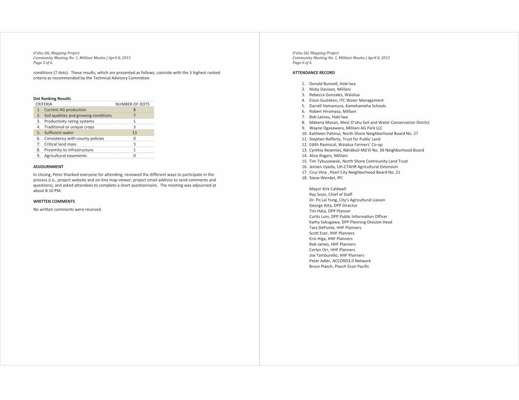
DOT RANKING
Each attendee was given three colored ½ inch “dots” when they signed in. Attendees were asked toplace the dots next to the individual criteria they felt were the most important for IAL mapping.According to the results of the dot ranking exercise, the top 3 priority criteria were: Criteria 5 SufficientWater (13 dots), Criteria 1—Current AG production (8 dots); and Criteria 2—Soil qualities and growing
O‘ahu IAL Mapping ProjectCommunity Meeting No. 1, Mililani Mauka | April 8, 2015Page 5 of 6
conditions (7 dots). These results, which are presented as follows, coincide with the 3 highest rankedcriteria as recommended by the Technical Advisory Committee.
Dot Ranking ResultsCRITERIA NUMBER OF DOTS1. Current AG production 82. Soil qualities and growing conditions 73. Productivity rating systems 14. Traditional or unique crops 35. Sufficient water 136. Consistency with county policies 07. Critical land mass 38. Proximity to infrastructure 19. Agricultural easements 0
ADJOURNMENT
In closing, Peter thanked everyone for attending, reviewed the different ways to participate in theprocess (i.e., project website and on line map viewer, project email address to send comments andquestions), and asked attendees to complete a short questionnaire. The meeting was adjourned atabout 8:10 PM.
WRITTEN COMMENTS
No written comments were received.
O‘ahu IAL Mapping ProjectCommunity Meeting No. 1, Mililani Mauka | April 8, 2015Page 6 of 6
ATTENDANCE RECORD
1. Donald Bunnell, Hale‘iwa2. Nicky Davison, Mililani3. Rebecca Gonzales, Waialua4. Elson Gushiken, ITC Water Management5. Darrell Hamamura, Kamehameha Schools6. Robert Hiromasa, Mililani7. Bob Leinau, Hale‘iwa8. Makena Mason, West O‘ahu Soil and Water Conservation District9. Wayne Ogasawara, Mililani AG Park LLC10. Kathleen Pahinui, North Shore Neighborhood Board No. 2711. Stephen Rafferty, Trust for Public Land12. Edith Ramiscal, Waialua Farmers’ Co op13. Cynthia Rezentes, N n kuli M ‘ili No. 36 Neighborhood Board14. Alice Rogers, Mililani15. Tim Tybuszewski, North Shore Community Land Trust16. Jensen Uyeda, UH CTAHR Agricultural Extension17. Cruz Vina , Pearl City Neighborhood Board No. 2118. Steve Wendel, IPC
Mayor Kirk CaldwellRay Soon, Chief of StaffDr. Po Lai Yung, City’s Agricultural LiaisonGeorge Atta, DPP DirectorTim Hata, DPP PlannerCurtis Lum, DPP Public Information OfficerKathy Sokugawa, DPP Planning Division HeadTara DePonte, HHF PlannersScott Ezer, HHF PlannersErin Higa, HHF PlannersRob James, HHF PlannersCorlyn Orr, HHF PlannersJoe Tamburello, HHF PlannersPeter Adler, ACCORD3.0 NetworkBruce Plasch, Plasch Econ Pacific

Pacific Guardian Center 733 Bishop Street, Makai Tower Suite 2590 Honolulu, Hawai‘i 96813
Date: April 15, 2015
Time: 5:30 8:30 PM Project Name: O‘ahu IAL Mapping Project
Location: Windward Community CollegeHale Akoakoa, Rooms 102 105
Recorded by: Corlyn OrrReviewed by DPP: May 7, 2015
Attendees: see attendance record
Subject: Community Meeting
The second of three community meetings for the City’s Important Agricultural Lands (IAL) MappingProject was held at Windward Community College on April 15, 2015. This was the second meeting in aseries of three (the first was held on April 8, 2015 at Mililani Mauka Middle School Cafeteria and the thirdis scheduled for April 29, 2015 at Kapolei Hale). The meeting was scheduled from 5:30—8:30 PM, with anopen house from 5:30—6 30 and a formal presentation and discussion session from 6:30—8:30. Themeeting purpose was to present an overview of the project, answer questions and gather public input.
WELCOME, INTRODUCTIONS, AND PROJECT BRIEFING
Peter Adler, meeting facilitator, called the meeting to order sharply at 6:30 PM. Art Challacombe,Department of Planning and Permitting (DPP) Deputy Director welcomed everyone and offered openingremarks, which included thanking attendees for taking time to attend the meeting, his personal affinityfor on going agricultural restoration efforts in He‘eia, and a general statement about the importance ofIAL. Following introductions of DPP staff and the planning team, Peter then reviewed the meetingagenda and the project goal to identify high quality farmland for use by future generations. Scott Ezer,principal with HHF Planners, provided a 30 minute briefing that included an overview of the IAL mappingprocess and a summary of the criteria weighting methodology and the proposed highest ranked criteria.
OPEN QUESTIONS
The briefing was completed at about 7:15 PM, and was followed by an open question and answer sessionfacilitated by Peter. The scheduled agenda called for the second half of the meeting to be allotted tosmall group discussions (breakout sessions). Due to the volume of people wanting to ask questions, themajority of attendees indicated their preference to forego the small group discussion and instead use thetime to continue the question and answer session. The following summarizes the main points of thediscussion.
The “51 49 rule” provides landowners who designate more than 50 percent of their landholdingsisland wide (excluding lands in the State Conservation District) an exemption from the countyIAL designation process. The rule was intended to be an incentive for landowners to pursue IALon their own, in advance of the county designation process. For clarification, a landowner whovoluntarily designates more than 50 percent of their landholdings as IAL could theoretically seekto urbanize the remaining 49 percent not designated IAL. The proposed M laekahanadevelopment is currently outside the City’s Urban Growth Boundary, in which case HawaiiReserves, Inc. (HRI) would have to get approvals for a number of different land use entitlementsbefore being able to develop their lands. The first step would be move the Urban GrowthBoundary so the project area is inside the UGB. If the project area remains outside the UGB, theexisting agricultural designations would continue and no further land use permits could be
MEETING SUMMARY
O‘ahu IAL Mapping ProjectCommunity Meeting 1, Windward Community College | April 15, 2015Page 2 of 8
pursued. If the project area is inside the UGB, the next step would be to petition the State LandUse Commission to change the land use designation from Agricultural to Urban, followed by azone change at the county level.
The “85/15 rule” is a process in the State law that allows a landowner to urbanize some land thatwould be included in the same petition submitted to designate lands for IAL. Following the 85/15rule, a landowner with 100 acres of land could designate 85 acres (85 percent) for IAL, and theremaining 15 acres (15 percent) could be simultaneously reclassified from the State AgriculturalDistrict to Urban, provided the land was consistent with the county general plan and thesustainable communities plan (SCP) or development plan (DP) on O ahu.
Only land in the State Agricultural District is eligible for IAL. Most of Kahalu‘u is being used foragriculture, but has been in the State Urban District since the 1960s when the City’s policy calledfor developing Kahalu‘u as the second city. Although the City’s policy has changed andKapolei/‘Ewa is now the second city, Kahalu‘u remains designated for urban use. Petitioning theLUC is the only way to change the designation.
There is no process for an individual or community group to petition the LUC for IAL designationon a parcel of land they do not own. The county initiated process is how the communityprovides input about which lands they think should be considered for IAL.
Since the 1977 General Plan, growth has been directed to Kapolei/‘Ewa, Central O‘ahu, and thePrimary Urban Center. Because the General Plan does not include maps that specify whereurbanization should occur, the maps and growth boundaries in the sustainable communitiesplans (SCPs) and development plans (DPs) are being used to define the extent of O‘ahu’surbanized areas. This project is consistent with the General Plan and the subsequent plans; landidentified in the SCPs/DPs for urban use (i.e., land inside the Urban Growth Boundary) is notbeing considered in the IAL mapping. The project scope is limited to considering the criteria andstandards established by the legislature; any discussion about the growth boundary relative toM laekahana is unrelated to this project.
HRI will be destroying heiau and taking kuleana lands to access the proposed M laekahanadevelopment. The traditional practices and rights of Native Hawaiians are being threatened andviolated. How is the IAL process protecting konohiki and kuleana lands? What is being done tohelp ensure the rights of Native Hawaiians, including konohiki and kuleana landowners, areprotected? The IAL designation is focused on which lands to be secured for future agriculture,and is an additional layer of protection for AG uses. IAL will not take away land from alandowner, change the use of the land, or change a landowner’s right to use their land. Thestate/county land use system treats kuleana lands like all other lands on the island, and theselands are not exempt from state land use classification or county zoning. Kuleana lands would beincluded in the IAL study area if they are in the State AG District.
A landowner that identifies 51 percent of his property as IAL and wants to develop the non IALportion would still need to go through the permitting process before being able to develop. The51 49 rule does not automatically give development rights for the non IAL portion. Anydevelopment on the portion not designated IAL would need to be consistent with State andCounty land use plans, including: (1) approval from the LUC to change the State land usedesignation from the Agricultural District to the Urban District; (2) consistency with the GeneralPlan; (3) designated for urban use in the County SCPs/DPs; and (4) zone change approval forurban use.
O‘ahu IAL Mapping ProjectCommunity Meeting 1, Windward Community College | April 15, 2015Page 3 of 8
There are two ways to change the Urban Growth Boundary in the SCPs/DPs: the first is during theCity’s five year review process, and the second is for a landowner to submit an individualapplication. The City Council has the power to change/adopt the General Plan, the SCPs/DPs andzoning changes. Both the Ko‘olau Loa SCP and Ko‘olau Poko SCP five year reviews are currentlyunderway. To clarify, Ko‘olau Loa SCP Revised Plan passed out of City Council Zoning andPlanning Committee, and is waiting full hearing by the City Council (pending the General PlanUpdate). There are no growth boundaries in the General Plan, only growth policies. The growthboundaries are established in the SCPs/DPs.
DPP is in the process of updating the General Plan. There is no growth policy underconsideration in the General Plan Update that would create a loop hole for affordable housing.However, there is a standing state law that allows affordable housing projects approved by CityCouncil to bypass the SCPs/DPs and zoning reviews in the name of affordable housing.
DPP is aware of the landowner in M laekahana that is bulldozing wetlands. DPP has met withthe U.S. Army Corps of Engineers to address the situation. The landowner was cited and told toremediate and restore the wetland, pending the threat of fines. This is a violation of Federal law.
The reference to “75 years” in our discussion about the land agriculture will need in the future isfor discussion purposes only. Although the standard is to plan and care for the land thinkingabout seven generations out, the 75 year horizon is being used because it is easier to visualizethe future in the context of three generations.
This is the only meeting scheduled for Windward O‘ahu. It was suggested that Ko‘olau Loa andKo‘olau Poko have separate meetings; there should be another meeting held just for Ko‘olau Loa.
The selection of TAC members seems to be biased towards individuals who require high soilquality, which may have influenced the outcome of the highest ranked criteria (e.g., soil qualitywas selected by the TAC as one of the important criteria). Soil quality is immaterial forhydroponics/aquaponics and aquaculture. These industries require a different set of criteria thantraditional agriculture. For example, solar radiation is one of the important criteria forhydroponics, but the areas being considered by this process are in the less sunny areas of theisland. Likewise, brackish water and sea water, which are useful for aquaculture, are notaddressed by the criteria and have not been mapped.
The TAC members were selected in consultation with DPP and the City’s AG liaison. Criteria werenot pre determined, other than involvement in the AG industry, being a farmer or a landowner ofAG land. Several of the organizations represented on the TAC were specified in the state law.
Land designated for urban use by the State or County—such as the Ho‘opili project which iswithin the City’s UGB—cannot be considered for IAL. This is clearly stated in the state law.Although the City Council passed Resolution 12 23 to include agriculturally productive landswithin urban growth boundaries, considering Ho‘opili for IAL would be in violation of state law.
Conscious effort was made to include representatives of different types of farming activities onboth the TAC and focus groups. The TAC included both small and large farmers, taro farmers,nurseries, ranchers and landowners. Organic farmers were included in the focus group meetings.
The process to incorporate lands designated as IAL and the other, non designated agriculturallands into the General Plan and SCPs/DPs will follow after the county’s IAL identification processis completed. The IAL inventory needs to be approved before DPP can consider revisions to theCity’s plans (i.e., the General Plan, SCPs/DPs) and policies (i.e., zoning. permit regulations). DPP
O‘ahu IAL Mapping ProjectCommunity Meeting 1, Windward Community College | April 15, 2015Page 4 of 8
originally wanted to include the IAL designation process in the SCP/DP five year reviews. Fundingconstraints, the level of detail required to apply the IAL standards and criteria, and a lack ofcommunity interest led to IAL being implemented separately from the SCP/DP revisions. DPP isnot fast tracking the IAL process to accommodate the SCP/DP revision schedules.
There are a number of systemic flaws with the process: (1) the selection of individuals andorganizations involved in discussions about the criteria (different organizations would havechosen different information to come with different outcomes); (2) kuleana lands and NativeHawaiian issues are not addressed; and (3) DPP is taking a disjointed approach to revising theGeneral Plan, SCPs/DPs and IAL. There is no integration in the planning, and the community isunsure about how to give input into the different processes and also unsure about how decisionmakers are using the community’s input.
During the time that passed between the 1978 Constitutional Convention and this current effort,a lot of the valuable agricultural lands on O‘ahu has been developed. In excluding Ho‘opili fromconsideration, DPP is cherry picking and operating just to move the process along. There is norecognition in the process about what is needed for the community to be sustainable or theimportance of agricultural productivity. DPP should be more pro active in its recommendation tothe City Council, and acknowledge the value of Ho‘opili (e.g., lands are actively farmed, has goodsoil and solar conditions).
The county is mandated with two responsibilities for IAL: mapping and developing incentives forfarming. DPP will start on the incentives when resources are made available for such an effort.
Planning for agriculture in Punalu‘u with Kamehamaha Schools was done with a number ofdifferent agencies and interests, including USGS, USACE, Board of Water Supply and NativeHawaiian farmers. The health of the underlying aquifer and the effects of chemicals andpesticides on the health of the land were primary objectives for the plan. Recommendationsincluded opening up ‘auwai, protecting the aquifer, and protecting submerged lands. NativeHawaiian traditions and practices, water quality and protection for submerged lands should beconsidered in the process to identify IAL. Cultural practitioners, as well as kuleana and konohikilandowners, should also be consulted and included in the IAL process.
There are no AG 1 and AG 2 zoning designations that come out of this process. This project willnot change zoning or allow for development; all this project will do is specify which lands shouldbe set aside for agriculture and protected from urban development. Not being designated IALdoes not mean that the land will be developed.
Issue is that all AG land is important.
If IAL does not get identified, the status quo will continue, and there will be no resolution formanagement of the State AG district. Without IAL, there will be no differentiating between goodand poor AG land in the State AG district, and all lands will continue to be treated the same. Inaddition, there will be no state or county incentives for farming.
The social expectation is that IALs will be used for food crops, not energy producing crops (e.g.,wind farms, solar farms). However, the law is silent on what kind of crops are grown and thetype of agriculture the land is used for. While the intent of IAL is farming, there are no regulatorymechanisms to require that the land is used for food crops. This process is limited to specifyingwhich lands need to be set aside. Changes to the state land use law and county zoning ordinancewould be necessary to differentiate between energy generating crops and non foodconsumption AG.

O‘ahu IAL Mapping ProjectCommunity Meeting 1, Windward Community College | April 15, 2015Page 5 of 8
This process is flawed, and needs better integration with the county’s other plans. More time isneeded to develop a plan that can be supported by the community.
The IAL designation provides an additional layer of protection for AG land because a supermajority vote of the LUC is required to take IALs out of the State AG Land Use District.
The effort to restore lo‘i in He‘eia is expanding agriculture from mauka to makai, and is utilizingthe estuary. A new criteria should be added to recognize the estuary, if used to supportagriculture. (Note: taro production is one of the criteria).
A private landowner who does not want their property to be designated as IAL by the City’sprocess would have to present their case to DPP and/or the City Council.
The questions from the breakout sessions will be posted on the project website. Meetingattendees were encouraged to review the website and submit written comments via the projectemail address.
DOT RANKING
Each attendee was given three colored ½ inch “dots” when they signed in. Attendees were asked toplace the dots next to the individual criteria they felt were the most important for IAL mapping.According to the results of the dot ranking exercise, two criteria that were written in by meetingattendees received more than half of all the dots:
Hawaiian—Kuleana lands. All land important AG land (26 dots)
All lands are important (13 dots)
Of the nine criteria that were reviewed by the project’s technical advisory committee (TAC), the 3 criteriathat received the most dots were: Criteria 1—Current AG production (15 dots); Criteria 5 SufficientWater (6 dots); and Criteria 2—Soil qualities and growing conditions (5 dots). These results, which arepresented as follows, coincide with the 3 highest ranked criteria as recommended by the TAC.
Dot Ranking ResultsCRITERIA DOTS
1. Current AG production 152. Soil qualities and growing conditions 53. Productivity rating systems 24. Traditional or unique crops 15. Sufficient water 66. Consistency with county policies 17. Critical land mass 08. Proximity to infrastructure 09. Agricultural easements 010. Hawaiian—Kuleana lands. All land important AG land 2611. All AG lands are important 13
ADJOURNMENT
In closing, Peter thanked everyone for attending, reviewed the different ways to participate in theprocess (i.e., project website and on line map viewer, project email address to send comments andquestions), and asked attendees to complete a short questionnaire. The meeting was adjourned at8:30 PM.
O‘ahu IAL Mapping ProjectCommunity Meeting 1, Windward Community College | April 15, 2015Page 6 of 8
WRITTEN COMMENTS
Written comments that were submitted during the meeting are documented below.
1. The City process ignores the laws established in 1978, 2005 and 2008. The slow process ignoresAG land and production. Address the accuracies of timeline and criteria. IAL must take intoaccount the historic process and uses.
2. The information is too ambiguous and extensive to appeal to the average person. The impact tothis process eliminates average individuals to understand the impact social, cultural, political,economic. This process appears to be fair and informative, which it is not.
3. Land that meets any of the top criteria should be included. Access to infrastructure should bemapped/qualified somehow; lands without any could, while important, be far less likely to bebrought into production. Some clearer discussion and diagrams of the planning layers across thestate and what this discussion is about could help bound the range of discussion and keep thingson track and in focus.
4. Hawaiian kuleana lands. All AG land is important. Coast=limu=Hawaiian icebox.
5. All AG lands are important. We all need more food as this island gets more populated, not less.We are boxing ourselves through “semantic interpretation” of “important” AG lands. We haveproblems with the list of technical group, especially LURF and lots of agriculture groups.
6. What is the real purpose and intent of IAL? Who benefits? State, corporations, US mainlanddevelopers—all except the citizens or general population. Why should landowners, farmers,kuleana landowners adopt IAL? How do they benefit long term? Why this designation and whomade up these laws? What and how do they benefit?
7. While I understand the law discludes all lands within the urban use boundary, I HIGHLYrecommend that in the reports it be noted that lands within the urban use boundary should beeligible for consideration. For one, promoting agriculture within the urban area is importantbecause it places the products in immediate proximity to consumers; this aids farmers byreducing transportation costs in the face of rising energy costs. Furthermore, AG within theurban area creates a feasibility for part time farmers to exist, as they can live and work closetogether. From a farm labor standpoint, this would hopefully foster an environment where morepeople can be involved in the production of their food, whether they are full time, part time orvolunteers.

O‘ahu IAL Mapping ProjectCommunity Meeting 1, Windward Community College | April 15, 2015Page 7 of 8
Attendance Record
1. Andrea Anixt, Ka‘a‘awa2. Joseph Blanco, Honolulu3. Jean Carroll, Kailua4. Carleton Ching, Castle & Cooke5. K.C. Connors, Ko‘olau Loa6. Robert Kealoha Domingo, Ka‘a‘awa Community Association7. Ruby Edwards, Office of Planning8. Kent Fonoimoana, Kahuku9. Ken Furukawa, Hau‘ula10. Burt Greene, Hau‘ula Community Association11. Nama Hara, K ne‘ohe12. Hunter Heaivilin, APCRD13. Didi Herron, Kahuku14. Suzi Horan, K ne‘ohe15. Choon James, L ‘ie16. Rocky Kaluhiwa, Ko‘olaupoko Hawaiian Civic Club17. Jerry Kaluhiwa, Kako‘o Oiwi, Ko‘olaupoko Hawaiian Civic Club18. Sydney Keliipuleole, Kamehameha Schools19. Dotty Kelly Paddock, Hau‘ula20. Donna Kohls, K ne‘ohe21. Crystal Kua, SunEdison22. Ron Kubo, K ne‘ohe23. Russell Lake, K ne‘ohe24. C.N. Lee, UH CTAHR25. Diane Ley, USDA Farm Service Agency26. Jenn Linton27. Pauline MacNeil, Kailua28. Ieti Maushau, L ‘ie29. Fred Mencher, Mokul ‘ia30. Clifford Migita, Waim nalo31. John Morgan, Kualoa Ranch32. David Mulinix, Wai‘anae Coast Comprehensive Health Center33. Joshua Noga, Hau‘ula34. Liz Nelson, K ne‘ohe35. Yvonne Nelson, K ne‘ohe36. Flora Obayashi, Kahalu‘u37. Paula Ogami, K ne‘ohe38. Christian Palmer, Windward Community College39. Sherry Pollack40. Bill Quinlan, Hale‘iwa41. Stephen Rafferty, Trust for Public Land42. Nick Reppun, Kako‘o Oiwi43. Brew Rudd, Hau‘ula44. Dan Taram, Friends of M laekahana
O‘ahu IAL Mapping ProjectCommunity Meeting 1, Windward Community College | April 15, 2015Page 8 of 8
45. Siosifa Tiueti, TriFormYard Service46. Dawn Wassson, L ‘ie47. Harry Wasson, L ‘ie48. Joe Wilson, Hale‘iwa49. Donna Wong, Hawai‘i's Thousand Friends50. Jane Yamashiro, Honolulu
Art Challacombe, DPP Deputy DirectorTim Hata, DPPKathy Sokugawa, DPP Planning Division HeadTina Bushnell, HHF PlannersTara DePonte, HHF PlannersScott Ezer, HHF PlannersRob James, HHF PlannersCorlyn Orr, HHF PlannersJoe Tamburello, HHF PlannersPeter Adler, ACCORD3.0 NetworkKem Lowry, ACCORD3.0 NetworkBruce Plasch, Plasch Econ Pacific
Pacific Guardian Center 733 Bishop Street, Makai Tower Suite 2590 Honolulu, Hawai‘i 96813
Date: April 29, 2015
Time: 5:30 8:30 PM Project Name: O‘ahu IAL Mapping Project
Location: Kapolei Hale Conference Rooms A C Recorded by: Corlyn OrrReviewed by DPP: May 29, 2015
Attendees: see attendance record
Subject: Community Meeting
The third community meeting for the City’s Important Agricultural Lands (IAL) Mapping Project was heldat Kapolei Hale on April 29, 2015. This was the third and final meeting in a series of three (the firstmeeting was held on April 8th at Mililani Mauka Middle School Cafeteria; the second was held on April15th at Windward Community College). The meeting purpose was to present an overview of the project,answer questions and gather public input.
Like the other two meetings, the Kapolei meeting was scheduled from 5:30—8:30 PM, with an openhouse from 5:30—6 30 and a formal presentation and discussion session from 6:30—8:30. Before thestart of the meeting, a group organized outside Kapolei Hale on Ulu‘ohia Street to demonstrate theiropposition to the Ho‘opili development proposal and the resulting loss of agricultural land. Since anumber of individuals had received inaccurate information that Ho‘opili would be on the meetingagenda, members of the planning team began explaining during informal conversations before andduring the open house session that Ho‘opili was not included in the study area because it was outside theState Agricultural District and that the meeting to discuss Ho‘opili would be before the City CouncilPlanning and Zoning Committee the following morning.
WELCOME, INTRODUCTIONS, AND OPEN COMMENTS
Peter Adler, meeting facilitator, called the meeting to order sharply at 6:30 PM. He asked the group toindicate by a show of hands who came to talk only about the Ho‘opili proposal and who came to talkabout all of O‘ahu’s agricultural lands. Of the 40 people in attendance at the time the question wasasked, the majority of attendees indicated they were there because of Ho‘opili.
George Atta, Department of Planning and Permitting (DPP) Director, then welcomed everyone andoffered opening remarks, which included thanking attendees for taking time to attend the meeting,stating his personal commitment to completing the IAL mapping, and noting the importance of the IALdesignation to the overall structure of land use policy and agriculture on O‘ahu.
Following introductions of DPP staff and the planning team, Peter reviewed the house rules and openedthe floor for comments about Ho‘opili. Roughly 30 minutes were allotted for comments, in place of theformal presentation that was originally scheduled for the first part of the meeting. The followingsummarizes the main points of the speakers’ comments. Although summarized, the record reflects asaccurately as possible the comments expressed during the meeting.
DPP’s argument that this process cannot include lands designated for urban use (such as theHo‘opili project area) is incorrect. Ho‘opili is the best AG land in the state (e.g., has the mostsunshine, good growing conditions) and should be designated IAL. Resolution 12 23, passed bythe City Council in 2012, directs DPP to consider lands within the urban growth boundary (UGB)that are classified as prime agricultural lands for IAL designation, provided that water is available.This policy established by the City Council overrides the State law.
MEETING SUMMARY
O‘ahu IAL Mapping ProjectCommunity Meeting 1, Kapolei Hale | April 29, 2015Page 2 of 10
The red ilima, which was once considered to be extinct, came back to life on the land beingplanned for Ho‘opili. Protecting the Ho‘opili project area from urban development preservesland for native species and wildlife, which runs far deeper than preserving agricultural land. Thedraft criteria maps do not take into account providing potential habitat for endangered species.
Anywhere there is land available to grow food needs to be used to grow food because the islandneeds to be sustainable. The pre fab sprawl needs to be stopped because every town looks thesame. Development needs to get creative, and include art.
Kanahili Cultural Hui is organized to research the history and culture of ‘Ewa, and has writtentestimony in opposition to Ho‘opili. Based on personal research with attorneys and stateemployees, the IAL process violates the State Constitution. The county’s interest in completingthe IAL mapping is to “check the box” so rail construction and the Ho‘opili project can beexpedited. The county should follow the process in the law: map the Ho‘opili project area as IAL,and then have the developer petition the LUC to remove the IAL designation. Laura Thielen, theCity’s former AG liaison, said mapping would be easy since both ALISH and LSB maps show theHo‘opili project area as prime agricultural lands. The county’s actions are unconstitutional, andneed to be stopped in court like Sierra Club challenged the Koa Ridge project. IAL is a politicalprocess, not a scientific legal process like it is being presented.
Besides the State Constitution and county’s resolution, the process should recognize the rightthing to do based on soil conditions, food security, health. There is a nation of people who arestill here and have never been conquered. Listen to those people before you decide what to do.
We talk about land being sacred. The aina feeds us. There was a time when food didn’t have tobe brought in from somewhere else. The more houses built, the less land there is for food.
My goal for my life is to feed everyone. How am I supposed to do that when I can’t even feed thepeople on the beaches or my family? We need this land.
It seems that Ho‘opili has been purposefully taken out of the inventory. DPP’s job is to map IALso the City Council has information to make good decisions. DPP needs to tell the City Councilthat Ho‘opili land is good AG land. If the City Council knew that the land was good quality AGland, they may decide against developing Ho‘opili.
RESPONSE: DPP has told the City Council that Ho‘opili occupies good AG land. The quality ofthe land is not in question. There are other reasons for supporting Ho‘opili.
Thank you for taking action. People have come to this meeting because the process has takentoo long. Designating IAL was added to the Constitution in the 1970s because development wasrampant, and the Hawaiian voice came forward to preserve what was there. Waik k was built onAG land; Kapahulu and Waik k were lo‘i before. IAL was supposed to be designated beforeanything was zoned for urban use. We wouldn’t have this conflict now if urban developmentwas planned around IAL.
DPP has to take care of this issue and complete the mapping before moving forward with newdevelopment like Ho‘opili. If DPP acknowledges that Ho‘opili should be mapped IAL and followsthrough with the constitutional mandate, everyone could move forward and support this project.
The bottom line is to stop development and feed the people. My people have been here a longtime; we need what we grow and we have to take care of our people. If we keep building, therewon’t be land for growing, we won’t have food, we will die. Too much planning doesn’t makesense. Grow food, not houses. Grow houses in Waik k or grow upward. We want to stay herefor the rest of our life, my children after me want to be here.

O‘ahu IAL Mapping ProjectCommunity Meeting 1, Kapolei Hale | April 29, 2015Page 3 of 10
Everything we say is falling on deaf ears. Decisions have already been made about Ho‘opili. Ourpolitical leaders are putting profits ahead of the people they represent. Our political system is nolonger the will of the people, but the will of the corporation where the bottom line is everythingand people don’t matter. The land under Ho‘opili is sacred because this is the only land thatturns four crops a year. Greedy corporations are going to destroy land that took thousands ofyears to create and give our kids a future that we don’t want. We import too much of our food.Tell the powers to stop, back up, rethink, and give us back our land.
The land they are considering paving over for housing is a gift of nature. We can’t get primeagricultural land back once homes are built. A UH professor who specializes in soil quality saidthat the Ho‘opili land is the best in the nation. Corporations will pay top dollar for the landbecause it has good sunshine, good quality water, and can grow four crops a year, unlike themainland. Our politicians are going to throw it away for housing that local people cannot afford.O‘ahu already has the worst traffic in the county; new houses will just make the traffic worse.
We’re importing food, and importing people and building houses to import those people. Theproblem is that the people being imported are not supporting local people. Redesignating thisland for Ho‘opili and paving it over only adds to our existing problems. We’re not trying to add tothe problem, we’re trying to solve the problem. Who is going to listen to our opinions? It’s up tous to inform other people and find a representative who is willing to listen and support us.
By a show of hands, there are about 20 farmers in attendance.
The majority of society’s health problems stems from people’s connection with food. My work atan organic farm is to affect change and help people live healthier, longer lives. Everyone needsto get their hands in the dirt and feel the land, which can’t happen without land.
The hypocrisy is that the project purpose is to identify high quality farm land, yet primeagricultural land in central O‘ahu is being left out. DPP will report that the process includedcommunity consultations, but the recommendations will not reflect people’s opinion. Ho‘opiliwould be included and mapped as IAL if the people’s opinion mattered. City Council membersneed to hear the people’s opinion to change Ho‘opili.
This former councilmember would be a direct witness in a lawsuit. The City Council adoptedResolution 12 23 by a unanimous vote based on agreement from DPP’s then director to map theland and agreement from Laura Thielen, the City’s AG liaison at the time, that mapping could bedone within one year. In 2011, the DPP director also indicated that the O‘ahu General Planwould be completed within a year. Video recordings confirm these statements. The differencebetween the previous and current administrations is problematic.
PROJECT BRIEFING AND OPEN QUESTIONS
Peter summarized the project goals: to develop an island wide inventory of agricultural resources to bepreserved for future agriculture and to develop criteria to be used in the mapping process. Peter alsoreviewed the meeting agenda for the remainder of the meeting, which included a project briefingfollowed by a question and answer session. Meeting attendees were encouraged to stay and learn aboutthe project and participate in the discussion about the island wide inventory and the criteria.
At 7:20 PM, Scott Ezer, principal with HHF Planners, conducted the briefing. The presentation includedan overview of the IAL mapping process, a summary of the criteria weighting methodology and a reviewof the highest ranked criteria. The briefing was completed at about 7:45 PM, and was followed by aquestion and answer session facilitated by Peter. The following summarizes the main points of thediscussion, and reflects as accurately as possible the speakers’ comments as stated during the meeting.
O‘ahu IAL Mapping ProjectCommunity Meeting 1, Kapolei Hale | April 29, 2015Page 4 of 10
Ho‘opili is part of Honouliuli, which has historically produced food and was one of the biggest lo‘ion this side of the island. Historically, Kualoa and Honouliuli were the two places on O‘ahu thatwere sought after and fought over because they were important areas for food production. Ifthe purpose is to identify high quality farm land like Ho‘opili, it should logically be mapped. Froman islandwide perspective, Ho‘opili is the only land in danger of development and should be firstto be mapped IAL. Other agricultural lands on O‘ahu are not endangered. Why avoid it?
RESPONSE: The process to map IAL is driven by a legal mandate that does not allow formapping lands already designated for urban use. Unfortunately, decision making aboutHo‘opili is beyond the scope of this project. The final report can only document thecommunity’s sentiments about where the high quality farm land is located.
This project has been done well. DPP has been thorough; all the pieces make sense. If everyoneagrees that Ho‘opili is high quality farmland, why isn’t anyone willing to stand up and map it?
RESPONSE: This is due to a basic difference in how people are interpreting the law. ForDPP, the law says that land designated for urban use cannot be mapped. Legal policies atboth the state and county level which already designate the land for urban use (i.e., StateLand Use Districts and county Development Plans/Sustainable Communities Plans) needto be changed for this area to be included.
Who is responsible for the decision to urbanize Ho‘opili? Who does this group need to see tostop Ho‘opili and have it included in the IAL mapping?
RESPONSE: The City’s policies for how development has occurred on O‘ahu date back to1977 when the City Council adopted the General Plan (GP). In the 1960s, the GPidentified Kahalu‘u as the area to be urbanized first. In 1977, the City Council approvedthe policy to direct growth to ‘Ewa and Central O‘ahu. By the early 1980s, the firstdevelopment plans were adopted, with Kapolei, ‘Ewa and Central O‘ahu identified forfuture urban use. The City Council continues to follow these policies when deciding whatareas should be urbanized and granted zone changes. To be able to include Ho‘opili inthe IAL mapping process, approvals from both the State Land Use Commission and CityCouncil to change the land use classification/zoning would be necessary.
What is the basis for the urban growth boundary (UGB)?
RESPONSE: The UGB is established by the ‘Ewa Development Plan, which was adopted in1997. Changing the UGB requires community action to push for City Council approval.
The Development Plans are supposed to be updated every five years. The ‘Ewa DevelopmentPlan should have been reviewed every five years, and the UGB should have been moved to adjustfor conditions at the time. How does excluding Ho‘opili meet the stated project objective to“frame the long term vision of high quality farmland that will be protected from futuredevelopment and used for productive agriculture?”
RESPONSE: The eligibility requirements for IAL do not allow for including Ho‘opili in thisprocess. The stated project objective takes a broader, islandwide perspective and appliesto areas that meet the eligibility requirements (i.e., within the State Agricultural District).
All AG land should be looked at as part of the broader picture. Ho‘opili is part of the largerbroader picture. The City is trying to divert the public’s attention away from the big picture bynot addressing Ho‘opili. We import most of our food, and what is grown is primarily for export(e.g., mac nuts and coffee). We should be tearing down developments to add more AG land.
O‘ahu IAL Mapping ProjectCommunity Meeting 1, Kapolei Hale | April 29, 2015Page 5 of 10
People making decisions about whether these lands are worth giving up don’t have farmingexperience. How are the decision makers qualified to make good decisions?
We implore you—the City’s consultant—to recommend that this process include Ho‘opili. Thiswould avoid a future lawsuit and save the City a lot of money, as well as be extremely effective toraise food and help fulfill the stated project objective.
Peter then asked the group to respond to a question: What is the additional data or information thatneeds to come forward because the City finalizes its plan?
When Aloun Farms relocated to ‘Ewa, they had to experiment with different crops to find outwhich crops grew well and which didn’t. Different plants need different conditions to grow well.Solar radiation (weather) and weather’s effect on the types of crops that can be grown should beadded as a criteria. As drafted, the current set of criteria maps do not take into account thegrowing conditions that are currently found among the warm, sunny areas with low lyingfarmland along the ‘ewa plain. Growing conditions in Waim nalo, North Shore and the centralslopes are different from ‘Ewa. This is the only hot weather area to grow crops.
The inference of designating certain land as IAL is that the other lands are not important and arevulnerable to future development.
One of my childhood memories is of my father taking us to the cane fields and visiting thegardens cared for by the plantation workers. It was the best tasting fruits and vegetables.Farmers should be farming that land because its good land.
How can the City Council, the mayor and agricultural liaison be wrong about the legality ofmapping IAL within the UGB? Is there a legal opinion that determined mapping IAL inside theUGB is unconstitutional? How can you assert it’s against the law without a judicial order?
There are other items that need to be included: cultural significance, spiritual value, andhistorical use of land (prior to its 20th century use for AG). The impact of this report on the futurealso needs to be considered because if this report does not look at Ho‘opili, it does not matter.Make this project worth the time.
What is the definition of “productive agriculture?” What types of crops are included? Does itinclude seed crops that are exported and grown using farming methods that pollute the watersupply and soil? Does it address self sufficiency and sustainable agriculture? National chemicalcorporations sat on the technical advisory committee, and are guiding this process.
RESPONSE: This process is looking at the physical conditions of the land and thequalifications of the land when the criteria are applied, not the types of crops beinggrown on the land. The goal for the IAL designation is to ensure that land is available forfarming so farmers have land to farm. The law is not meant to control how the land isused or what farmers choose to grow.
Land currently in production is one of the draft criteria. There are lands that are being held/banked(not currently in agriculture) that should be in production and used for diversified crops; theselands also need to be included in the mapping.
RESPONSE: We are asking for input on how the criteria should be applied. There are twoapproaches: apply the criteria strictly (e.g., land has to meet all of the priority criteria tobe IAL) or take a broad approach with the criteria to designate as much land as possible.
Who were the farmers on the technical advisory committee? Where are their farms? What istheir relation to the areas being recommended for IAL designation?
O‘ahu IAL Mapping ProjectCommunity Meeting 1, Kapolei Hale | April 29, 2015Page 6 of 10
RESPONSE: The “farmer” category included producers who used the land to grow. Smalland large farmers were involved, including seed corn producers. It was not possible tohave every farmer on the committee. (Note: The advisory committee roster is presentedin the April 2014 Phase I Report posted on the project website).
GMO fields are not agriculture. They are food like substances that use registered pesticides. Soilcontamination (resulting from pesticide use) should be added as a criteria. The goal should belocally grown food. If farmers who served on the advisory committee use pesticides, theirperspective is very narrow and different from what we want. We support a different form ofagriculture: a future with healthy people and healthy land, organic food, no spraying. We wantagriculture to grow food on live soil using water from healthy watersheds. Information aboutorganic farming and the systemic changes needed to promote organic farming is missing fromthe study. Korea is a model for organic farming. The current approach is not holistic.
The meeting coordinators are contracted by the City for a specific job. They have no authority toinclude Ho‘opili and other urban lands in the mapping. The City Council has decision makingpower to move the UGB and map Ho‘opili as IAL. Meeting attendees need to organize and carrythe momentum forward to the City Council. An upsurge of people can make a difference.
By a show of hands, none of the meeting attendees support the mapping process as proposed.About three fourths would support the process if Ho‘opili were eligible for mapping as IAL.
All properties zoned AG 1 should be designated IAL so land cannot be rezoned for churches orother non farm activities. (County zoning is not currently a criteria.)
All land in the State AG District should be included as IAL. Developers should be required toprove the land is not important instead of designating certain lands as important at the frontend. All agricultural land should be included, regardless of the location of the UGB.
This process is flawed because it clearly excludes some good AG land. Regardless of the flaws,delaying the entire process because of a single parcel is harmful for the future of the remainingAG land across the island. In weighing the consequences, it would be more productive to focuson enriching the process and expanding the inventory to include as much good, productive landas possible (i.e., focus the fight on things that can be controlled; do not throw this process outand end up with nothing protected). The best thing to do is to go to the source—the City Councilor the legislature—to change the process. AG land in Wai‘anae is being threatened. There areless farms in Wai‘anae, and what remains needs to be protected from future urbanization.
DOT RANKING
Each attendee was given three colored ½ inch “dots” when they signed in. Attendees were asked toplace the dots next to the individual criteria they felt were the most important for IAL mapping.According to the results of the dot ranking exercise, the one criteria that was written in by meetingattendees received almost 95% of the dots: Regenerative agriculture/organic (47 dots). The only othercriteria that received dots was: Criteria 1—Current AG production (3 dots). The results of the dot votingare presented in the following table.
O‘ahu IAL Mapping ProjectCommunity Meeting 1, Kapolei Hale | April 29, 2015Page 7 of 10
Dot Ranking ResultsCRITERIA DOTS
1. Current AG production 32. Soil qualities and growing conditions 03. Productivity rating systems 04. Traditional or unique crops 05. Sufficient water 06. Consistency with county policies 07. Critical land mass 08. Proximity to infrastructure 09. Agricultural easements 010. Regenerative agriculture (organic) 47
COMMENT STATION
Meeting attendees were encouraged to write their written comments on post it notes and place them ona display board. Written comments are documented as follows.
Buy local
Less people, more food
Import less
Keep AG land AG land
Keep the AG land in AG. DUH!
Eat fresh local
By giving them a chance to bring back the ahupua‘a system in this present day!
Grow food not houses
Visit yo’ farmers
Befriend a farmer
Politicians, stop taking bribes!
Shop at farmer’s markets
Don’t shop for can food!
Be intentional with what you eat. Food = Medicine
Grow
Go to Kahumana’s Farm Festival May 16th
Help farmers, especially small farms to gain certification as organic (expensive)
Help small farms to acquire food insurance in order to sell food to food markets (Foodland,Whole Foods)
Eat smart. Whole organic food is the best medicine.
ADJOURNMENT
In closing, Peter thanked everyone for attending, reviewed the different ways to participate in theprocess (i.e., project website and on line map viewer, project email address to send comments andquestions, comment sheet, and meeting questionnaire). The meeting was adjourned at roughly 8:35 PM.
O‘ahu IAL Mapping ProjectCommunity Meeting 1, Kapolei Hale | April 29, 2015Page 8 of 10
WRITTEN COMMENTS (Questionnaire)
Written comments that were submitted via the questionnaire during the meeting are documented asfollows.
1. The island is one of the most densely populated places on the planet. If the government is “forthe people” it would be an obvious decision to keep what little agriculture land that is leftAGRICULTURAL. This bill is about money and development. This state should be about its peopleand its aina. Make the right decision.
IAL has been represented as a turmoil of indecision and lack of knowledge. The overabundantamount of plants that can grow in limitless varieties of climates cannot be deemed important ornot. All plants are more important than urban development. High quality farmers can growsomething in any situation, climate or location.
2. The State Condition Article II.3 details what are IALs = soils of A and B. This is exactly the soils outat Honouliuli which is in grave danger of being paved over by the project Ho‘opili. This is atragedy.
All AG land is IAL.
The particular land at Honouliuli is highest productivity category and should be protected both bythe state Land Use Commission and the City and County of Honolulu.
Include Ho‘opili in this map. City and County already told you to include it.
3. Mahalo for this meeting. Thank you for opening up for community mana‘o and thank you forexplaining this process.
4. I am writing as a citizen, kama‘aina, mother, human. I am very saddened to know, thatunderstand that the decision to build on our AG land has already been predetermined, evenbefore we began this meeting. I have 2 children and we have visited Aloun farms, which is whereHo‘opili housing is supposed to be built. We have visited this place even before my children wereborn, years before. Yes, I am saddened because we will no longer be able to visit this farm whenHo‘opili is just housing. It seems to me that our county no longer cares about its people. Whatare businesses going to do when we can no longer support ourselves here on O‘ahu when thereis no longer agricultural land? How will my children survive? That is my question to you. Howwill my children survive? My grandchildren, your grandchildren. How will you sleep at nightwhen this happens? The government will not support us. Please give us our AG lands back. I amsick of just sitting and listening. That’s why I am here. I am here to make a difference as shouldeveryone. Please reconsider using our precious AG land in ‘Ewa. You will be destroying 40% ofour agricultural land. Some of the best in the world, and you know it. Please reconsider buildingon this land and give it back to the farmers, my children, family descendants, and friends. Thankyou.

O‘ahu IAL Mapping ProjectCommunity Meeting 1, Kapolei Hale | April 29, 2015Page 9 of 10
Attendance Record1. Kalani (Kahumana Farm) Wai‘anae2. Claire Baldry (Kahumana Farm) Wai‘anae3. Pat Beekman, ‘Aiea4. Charles Begeal, Wai‘anae5. Tom Berg, ‘Ewa Beach6. John Bond, Kapolei7. Donald Bunnell, Hale‘iwa8. Victoria Cannon, Makakilo9. Miles Dawson (Kahumana Farm) Wai‘anae10. Anthony Deluze, Ho‘ola Hou ia Kalauoa11. Michael Dennison (Kahumana Farm) Wai‘anae12. Dr. Kioni Dudley, Kapolei13. Ruby Edwards, State Office of Planning14. Al Frenzel, Makaha15. Danny Fulford (Kahumana Farm) Wai‘anae16. Kelii Gannet (Kahumana Farm) Wai‘anae17. Matt Gerkin, Hale‘iwa18. Kaipo Gora (Pae ‘ ina Landscaping) Hale‘iwa19. Gina Hara, K ne‘ohe20. Sanoe Iaca, Wai‘anae21. Jeanne Ishikawa, Wahiaw Neighborhood Board No. 2622. Chanel Kaleikini (Kahumana Farm) Wai‘anae23. Sam Kapoi, Wai‘anae24. Talyor Kellernan, Kunia25. W. Ken Koike, Wai‘anae26. Kristalena Lamore (Kahumana Farm) Wai‘anae27. Noe Lopes, Wai‘anae28. David Lopes, Wai‘anae29. John Henry Martin, Wai‘anae30. Summer Maunakea, Kunia31. Catherine Page, ‘Ewa Beach32. Peter McDonald (Kahumana Farm) Wai‘anae33. Joshua Morimoto (Kahumana Farm) Wai‘anae34. David Mulinix, K ne‘ohe35. Kaina Nakanealoha, Wai‘anae36. Evan Paul (Kahumana Farm) Wai‘anae37. Shari Quartero, Waipahu38. Jebson Quartero, Waipahu39. Marci Ramos40. Travis Renshaw, Kapolei41. Cynthia Rezentes, N n kuli M ‘ili Neighborhood Board No. 3642. Charleen Salazar, Wai‘anae43. Keanu Sanders (Pae ‘ ina Landscaping) Wai‘anae44. Jeanmarie Smith, Wai‘anae45. Kymberly Sparrow46. Thad Spreg, Makakilo Kapolei Honokai Hale Neighborhood Board No. 3447. Diana Stefano, Wai‘anae48. Mark Torreano, Waik k
O‘ahu IAL Mapping ProjectCommunity Meeting 1, Kapolei Hale | April 29, 2015Page 10 of 10
49. Jennifer Uphoff (Kahumana Farm) Wai‘anae50. Victor Villanueva, Kahuku51. Joycelee Walther52. Earl Yamamoto, State Department of Agriculture53. Christian Zukerman (Kahumana Farm) Wai‘anae
George Atta, DPP DirectorDr. Po Yung Lai, Mayor’s Agricultural LiaisonTim Hata, DPPCurtis Lum, DPPKathy Sokugawa, DPP Planning Division HeadTara DePonte, HHF PlannersScott Ezer, HHF PlannersErin Higa, HHF PlannersRob James, HHF PlannersCorlyn Orr, HHF PlannersJoe Tamburello, HHF PlannersPeter Adler, ACCORD3.0 NetworkBruce Plasch, Plasch Econ Pacific
Pacific Guardian Center 733 Bishop Street, Makai Tower Suite 2590 Honolulu, Hawai‘i 96813
Meeting Date: Tuesday, January 10, 2017
Meeting Time: 6:00 8:30 PM Project Name: O‘ahu IAL Mapping Project
Location: Kapolei Middle School Cafeteria Recorded by: Corlyn OrrReviewed by DPP Feb 16, 2017
Attendees: see attendance record
Subject: Community Meeting 2
This community meetings for the City’s Important Agricultural Lands (IAL) Mapping Project was held atKapolei Middle School on Tuesday, January 10, 2017. This was the first of two meetings to present theDraft IAL maps and explain the project.
WELCOME, INTRODUCTIONS, AND PROJECT BRIEFING
Scott Ezer, meeting facilitator, called the meeting to order sharply at 6:30 PM. Following welcomingremarks and introductions of DPP staff and the planning team, Scott provided a project briefing.
QUESTION AND ANSWER SESSION
Meeting participants were asked to submit their questions in writing. Scott read each of the followingquestions out loud and provided a response. Both the questions and responses have been documentednearly verbatim to maintain both the accuracy and authenticity of the statement.
1. Is this process about inventorying all AG land on O‘ahu or just the prime or best soil AG beinglands?
RESPONSE: The process is beyond inventory. It's trying to identify parcels that meet the criteria that havebeen selected as the most important ones, as I went through in the presentation.
2. What if my farm has already been professionally determined to be of poor quality soil? Will itstill be included in this inventory?
RESPONSE: I’ll be the first one to tell you that our data is not perfect. There will be some errors andmistakes, and that’s part of the purpose of making this a public process. If you feel that your land hasbeen identified for IAL designation in error, we encourage you to let us know and let us know why youthink that. Even to the point that if you want to remove your land from IAL designation, you should letthe City know that as well.
3. What are the benefits of having our land designated IAL?
RESPONSE: As I mentioned earlier, the biggest advantage to a landowner is being able to take advantageof the incentives that have been already identified and adopted by the State Department of Agriculture(DOA). There is no harm in being designated IAL, other than if at some point in the future, if you want tourbanize your land, the required vote at the State Land Use Commission (LUC) would be 6 to 3 instead of 5to 4.
4. Is the money given to begin farming come as a loan or a grant?
RESPONSE: I suggest you call the State DOA and ask them. I believe that information is available on ourFAQs, and see how you might take advantage of those incentives.
MEETING SUMMARY
O‘ahu IAL Mapping ProjectCommunity Meeting 2, Kapolei Middle School | January 10, 2017Page 2 of 15
5. What would our taxes be if our land is designated IAL? Will they go up?
RESPONSE: I cannot answer that question specifically because I don’t know. I doubt that taxes would goup. If you keep your land in agricultural designation, the County tax office will continue to tax you at anagricultural rate. There’s also an opportunity if you dedicate your land for agricultural purposesindependent of any IAL designation to get a reduction in your taxes.
6. How do we say no to having our land designated IAL, and what happens if we do?
RESPONSE: I think I provided you the opportunity and information necessary to contact the City andprovide us comments if you don’t want to be designated IAL. Even if you come up here tonight and youspeak and you don’t want your land IAL, that’s wonderful, but because of the process involved, it's reallyimportant that you provide us with written request so that there’s a record of what you asked for.
7. Define “sufficient quantities of water.”
RESPONSE: When we were looking at land, if land was irrigated there was a ditch, if the land had a wellon it, if it there are many agricultural properties that use Board of Water Supply water with anagricultural rate and there’s a record of those parcels with the BWS, that’s how we determined “sufficientquantities of water.”
8. What is the timeline for the entire process? Would it be months or years?
RESPONSE: I would hope that we are able a year from now to have maps before the City Council, if notsooner. I can’t predict how long it would take for the City Council to consider everything, and then move itup to the State Land Use Commission (SLUC), or even for the SLUC to complete its’ deliberations. Thishasn’t been done before. No county has come before us to do this. So we don’t have a template, wedon’t have an outline. We’re all learning as we go. It’s a very complicated process, and I just can’tanswer that question.
Scott introduced Kathy Sokugawa, the Acting Director of DPP, and asked her to answer a question onaccessory dwelling units (ADUs).
K. SOKUGAWA: Good evening everybody. Thank you so much for coming. I know everybody has very busylives but you took the time to come out, and I’m so happy that you did because all of us in this room careabout agriculture. Those of us at the city and at the state level are very anxious to formally, officially,finally adopt what we consider to be IAL on O‘ahu. This is a 1978 state constitutional as you heardearlier a 1978 constitutional mandate and here it is, 2016, and we just have draft maps now. We wouldlike to totally get your feedback and listen to your comments. We are implementing the state law. Weare not making up the rules by ourselves. We do have to as Scott mentioned comply with the Stateparameters, and so that’s what we are trying to do as part of this process. The question that I’m asked isabout ADUs.
9. If designated IAL, what happens if we want to remodel or improve the land specifically for ADUs?
RESPONSE (K. SOKUGAWA): The mayor is very supportive of ADUs. Currently the law only provides thatthey be allowed in areas zoned residential. By definition, if your zoned agriculture you are not eligible forADU. If your property is bigger than the minimum, and it’s big enough for second dwelling, then of courseyou can build a second or third dwelling depending on your lot size. For now, the ADU program is onlyavailable in residential areas. I think there are a couple questions on this issue.
I have another question here that I hope I can put Department of Agriculture on the spot and ask for EarlYamamoto to come up and answer this question about tax credits. In the meantime Scott will answerother questions.

O‘ahu IAL Mapping ProjectCommunity Meeting 2, Kapolei Middle School | January 10, 2017Page 3 of 15
10. What actions or data, if any, are the proposed landowners for IAL required to take before and afterthe designation process?
RESPONSE: IF you’re part of this process and your land is being recommended for designation as IAL, youdon’t have to do anything else. Your land will become part of the IAL process.
11. What was your process to determine what land is and should be IAL?
RESPONSE: I think I covered that in the presentation.
12. Are you saying that IAL protects land from big development?
RESPONSE: That’s a very complicated question. There are a lot of different land use policies that comeinto play that are supposed to protect land from development. Part of that has to do with what’s the landdesignated by County land use policies. County land use policies include the development plans, thesustainable communities plans, the General Plan, and also at the State level, whether the land is inAgricultural or urban. In order to get from AG to Urban, a landowner, a big developer, has to spend yearsgoing through the process to get some of those designations changed. In many cases, land has beendesignated for Urban use of one kind or another could be residential, commercial, or industrial onCounty policy maps for many, many years without that land ever being developed, but the long rangepolicy is for development. I know a lot of you have questions about that particular process, but the factthat the land is already designated or being proposed for designation for IAL already indicates that all ofthe land use policies at the county and state level require that that land be for agricultural purposes.Having the IAL designation is like putting a period at the end of that comment.
Scott introduced Earl Yamamoto, land use planner from the State DOA, to answer a couple of questions.
13. Your report to the 24th legislature indicates the tax credits expiring December 31st, 2017. Is thereany plan to continue or extend the tax credits?
RESPONSE (E. YAMAMOTO): The IAL qualifying agricultural cost tax credits otherwise known shorthandas the “tax credits” does expire in the current tax year, which is 2017. By the year 2018, if the Legislaturedoes not extend the tax credit, the last year for anyone to make claims with their qualified costs that arethe expenditures made on their designated IAL, that comes to an end with the current year. There islegislation to extend it, I believe 10 years. It’s an Administration proposal. As far as I know, it will bebrought forward and be part of the administrative package from the Governor.
14. Will financing be through HDOA which provides 85% guarantee?
RESPONSE (E. YAMAMOTO): I believe this question has to do with the loan guarantee program. Basicallythe State DOA’s agricultural loan program can, although we have not to my knowledge, we canguarantee a loan made by a commercial lending institution like a bank, to basically reduce their risk andencourage commercial lending activity on land designated IAL. I believe that’s what the question is.
15. What mechanism was used to reduce the original eight criteria from 8 to 3?
RESPONSE: The language in the State law that identifies the criteria says that the counties must considerthe eight criteria, but they don’t have to be uniformly applied. In discussions within our TechnicalAdvisory Committee, we went through a lengthy discussion process on which of the criteria were the mostimportant. How do you even go about trying to apply those criteria to land? After many weeks andmonths of conversation, the advisory committee voted and went through an exercise that identified thethree criteria that they thought were the most important. They had an opportunity after that processwe went back to the advisory committee and asked them if they were sure about their findings, and theywere. So that’s how we went from eight to three.
O‘ahu IAL Mapping ProjectCommunity Meeting 2, Kapolei Middle School | January 10, 2017Page 4 of 15
16. Does this process go against the 1978 ConCon?
RESPONSE: The answer to this question is no.
17. If the new designation won’t change/affect how I do things on my land, then why change thedesignation? Leave it as it is.
RESPONSE: The legislature felt that first of all they had to do something to comply with the ConstitutionalAmendment which required the counties to do something, which required the State to take some action.This is the implementation of that policy. The IAL process is really an opportunity for landowners to takeadvantage of some incentives to make improvements to their land. The position and the policy of theCounty is that this is a good thing, and it’s a good agricultural policy.
18. Once land is designated IAL, can that designation be reversed?
RESPONSE: Yes it can. You have to go back to the LUC and have it taken out of the IAL designation.
19. I’m a landowner and hope to pass my property to my children. They will need to enlarge ourexisting home and possibly build an ADU to accommodate them. Would they be able to do this in thefuture?
RESPONSE: Kathy just answered a question on ADUs. ADUs are not allowed in the State Agricultural orthe County agricultural districts. A farm dwelling on an agricultural zoned lot in the City and County ofHonolulu is allowed to have a footprint of 5,000 square feet. That means the house, garage, and anyaccessory uses or buildings to the house need to be limited to a footprint of 5,000 square feet. They cango up to 25 feet, which would be about two stories. There is no limitation on the floor area of thedwelling, it’s just limited to a footprint.
20. What is the current and long term future of the Waipi‘o farms across from Costco Waipi‘o, KoaRidge?
RESPONSE: Koa Ridge has received an Urban Designation by the State LUC and has been zoned forresidential and other uses by the City and County of Honolulu. The lawsuit in court, I can’t predict whatthe court will make of that.
21. How does a landowner change the designation of the property as AG 2 if it is believed that it doesnot meet the criteria?
RESPONSE: Again, I recommend that you contact the City. Send us an email or call Tim, but we will askyou to provide some written documentation of why you feel your property should not be in IAL or why youwant to pull it out of the process. A phone call or conversation will not be sufficient.
22. If I own one acre of land, can I designate a portion to IAL but not the entire property?
RESPONSE: It’s possible. If you went in as an individual landowner, there’s nothing in the law that has alimit or minimum size for designation as IAL. Any landowner can go in and petition the State LUC to be inIAL.
23. Can I refuse IAL designation as an individual landowner?
RESPONSE: You can ask to refuse, and I think it will be up the City and County DPP to consider yourrationale for not. It’s certainly your right to request that.
24. If I refuse, will I find myself subjected to higher taxes?
RESPONSE: That should not affect your tax rate.

O‘ahu IAL Mapping ProjectCommunity Meeting 2, Kapolei Middle School | January 10, 2017Page 5 of 15
25. How does this process protect konohiki, kuleana and DHHL land?
RESPONSE: Our process did not consider DHHL land because it’s owned by the State of Hawai‘i, and bylaw, the County is not allowed to consider DHHL land as part of this process. With respect to konohiki andkuleana lands, if the lands meet the requirements of any one of the three criteria, they are included aspart of the IAL designation. I went through the maps in some detail, and there are a number of kuleanaparcels that are included in the IAL designation.
26. Some properties in the 96792 M ‘ili area are not conducive for agricultural. They are only coralland. How is this to be resolved?
RESPONSE: Please let us know if you feel that lands have been designated in error. Again, I’ve providedmultiple ways to go about doing that.
27. Are there any penalties for opting out of the IAL designation?
RESPONSE: No penalties. If you request to have your land pulled out and it’s granted, it’s a straighttransaction.
28. I already have access to grants and farming classes, which I am taking advantage of. I also do allthe good stewardship practices. Therefore, why should I add additional layers of government rules andregulations where I am already have the benefits IAL designation offers?
RESPONSE: Again, if you feel you don’t want the IAL designation, please ask to be taken out.
29. You say no changes will be made to allowable uses. Is this a permanent promise that is in writing?
RESPONSE: I can promise you that as long as the land is designated Agriculture, the rules that apply toagricultural land will apply to your land. I can’t predict what the City Council or the LUC will do 15 or 20years from now with respect to land use policies. I can only tell you what I know is the practice today, andthere is no intent to change what you’re allowed to do.
30. It seems to me if farming was enforced in AG land with houses on it, IAL would not be needed.
RESPONSE: There’s certainly an argument in favor of stricter enforcement of agriculture rules onagricultural land.
31. If a landowner submits comments to DPP regarding the draft IAL designations, what can beexpected in response to the comments?
RESPONSE: You will receive a written response to your comment. First of all, all of the comments, all ofthese questions, all of these cards will eventually appear online. This will be a transparent process.Everything my answers to those questions included will be recorded online as well, so if you make achoice to contact DPP and submit comments to them about your land, then the Department will respondto your request or to your question.
32. Will this initiate a dialogue between the City and the landowner prior to DPP making its finalrecommendations to the Planning Commission and City Council?
RESPONSE: First of all, the Planning Commission is not involved. It would go directly to the City Council,and yes, this would initiate a dialogue.
33. For lands that have been identified as potential IAL based only on this soil type, as identified on theUSDA Soil maps, if a landowner has information that the soil map is incorrect and unsuitable foragriculture, will the City consider that information in its final recommendation regarding IAL?
RESPONSE: Yes.
O‘ahu IAL Mapping ProjectCommunity Meeting 2, Kapolei Middle School | January 10, 2017Page 6 of 15
34. Why was Ho‘opili not designated under HRS Chapter 205 44?
RESPONSE: I already covered that. I will repeat myself, and that is because Ho‘opili had been designatedfor urban and residential uses on the County ‘Ewa Development Plan and therefore it is not consistentwith the determination of IAL under State law.
35. Why is Monsanto land designated when it’s poisoned already?
RESPONSE: I don’t have enough information on that one.
36. My property has mixed zoning. Will the portion not AG be affected?
RESPONSE: No. If you think it is, and you think an error has been made, I encourage you to contact DPP.
37. What is the significant difference in IAL vs. agricultural land designated AG 1 or AG 2 now?
RESPONSE: The basic difference is that the designation of IAL opens up opportunities to take advantage ofincentives.
38. With IAL designation, will current laws regarding AG land be upheld and enforced?
RESPONSE: I can’t promise what the City or DPP will do. I know they take agricultural policies veryseriously, and they will do everything they can to ensure that AG land rules are upheld.
39. Who benefits from IAL designation, regarding legislation and the State DOA? Is there an IALdesignation quota (in terms of the number of acres, I assume)?
RESPONSE: We tried to again be as inclusive as possible, and we let the chips fall where they may in termsof how the land was identified.
40. How will it be more difficult to get permits and redesignation of State land use?
RESPONSE: I already identified that it would take a 6 to 3 majority in the State LUC, instead of a 5 to 4vote.
41. Can you give examples of what uses will be more difficult to get permission for?
RESPONSE: The only difficulty really would be to try and urbanize your land. If your land is zoned AG atthe county level again I repeat myself but you are entitled to take advantage of all the benefits thatagricultural zoning allows you. As long as you are pursuing a legal use or a use that’s identified in thezoning code, you’re good to go.
42. What uses are permitted on lands designated as IAL?
RESPONSE: The same uses that are currently allowed by County zoning or under the State Chapter 205.
43. What was the frequency noted in State law for review of IAL?
RESPONSE: I believe the language in the law says that the incentives are supposed to be reviewed everyfive years. I don’t know if there’s a requirement for the law itself to be reviewed.
44. Are you familiar with the letter to the Governor from FEMA to repeal the law on AG dwellings?
RESPONSE: I am not. We will get an answer to that, and it will be posted to the website.
45. The City and State expressed the need for sustainability yet they don’t even know the amount offood and produce that is grown in the State of Hawai‘i yearly.
RESPONSE: I don’t understand the question.
O‘ahu IAL Mapping ProjectCommunity Meeting 2, Kapolei Middle School | January 10, 2017Page 7 of 15
The individual who submitted the written question gave an oral explanation and repeated thequestion: We talk about sustainability for the entire state of Hawai‘i, yet we don’t know how muchproduce and food all these farmers produce every year. How do we get accurate counts? Does theState have data that identifies how much of the food that we consume in Hawai‘i is produced locally?
RESPONSE: We don’t have the numbers. In past years, the rule of thumb has been that we import 90% ofour food. We produce somewhere in the neighborhood of 30 35% of our produce, but a lot of the otherfood products beef, milk, chicken, dairy, all of that stuff is imported, so those are pretty rough numbers.
46. The findings of the advisory committee on what scientific studies are based? UH scientific studies?Are the source of the findings available to the public?
RESPONSE: The people that were on the advisory committee came from a pretty broad group of people.It included soil scientists, it included people from UH, farmers, it included a lot of different people, and thebasis of the conversation was based on the collective knowledge of all of the members of the advisorycommittee. All of the minutes and findings from those conversations are posted on the website. Weactually have a report from the Phase I part of this study that documents that question and it’s all online.You’re invited to go read that.
47. Is there a possibility that parcels zoned preservation that have been CPRed and been sold bedesignated as IAL?
RESPONSE: Probably not. If it’s zoned preservation and/or it’s in the State Conservation District, the lawsays we have to exclude those from consideration for IAL.
48. Is an IAL designation considered a “taking” in terms of limiting the use of one’s lands?
RESPONSE: I would say not. I’m not an attorney, but I don’t believe so.
49. Could you please list again what are the benefits to the landowner of having the land designatedIAL and how these benefits differ from having AG land not designated IAL?
RESPONSE: The benefits are basically access to the incentives that have already been adopted by theState, and you suffer no other consequence.
50. What impact will IAL have on legally, non conforming improvements on AG land?
RESPONSE: If they’re legally non conforming improvements, the IAL designation will have no effect.
51. I currently own a 5 acre zoned AG 1 lot and have been trying to get a permit for a barn for the pastsix months. Will voluntarily designating it IAL fast track getting my permit?
RESPONSE (K. SOKUGAWA): There’s lots of answers to this one. Hopefully, you should get a permit beforeyou even get the IAL because it’s going to take a lot of months before we get to formalization of IAL. Offline, after this, come and see me because I don’t why you’re having a difficulty. And actually, you mightnot even need a building permit. The State in its wisdom, chose to eliminate building permit requirementsand building code requirements for certain agricultural structures. So if you qualify under those criteria,you may not even need a building permit. But I don’t know the specific circumstances, so come see meafter this and we can talk about it.
52. Who is responsible for giving the ok for all four of the major solar farms in Waianae that are onPrime farmlands?
RESPONSE (K. SOKUGAWA): That is partly the Legislature’s decision by amending the State land use lawon what is permitted on agricultural lands. It was felt that solar farms were a legitimate use foragricultural lands. Again, that was something the Legislature chose to do.
O‘ahu IAL Mapping ProjectCommunity Meeting 2, Kapolei Middle School | January 10, 2017Page 8 of 15
OPEN FORUM
1. Renee Ing: Thank you for allowing me to speak. My name is Renee Ing and I would like to give mycomments about the IAL designation for Ho‘opili and Koa Ridge. Climate change is causing ice tomelt faster than we could imagine. The latest data is that in Antarctica, an iceberg the size ofDelaware is poised to drop into the ocean, beginning to trigger the dropping of massive amounts ofice into the ocean, making climate change worse. Climate change is causing floods, water shortages,droughts, climate catastrophes worldwide, and is already making food production more difficult,raising our food prices, and in the future, they’re predicting it will cause mass starvation and warsover resources. The military has been planning for these problems and their consequences fordecades. In the olden days, Hawai‘i fed our million people here from food grown on Hawai‘i’s landsand now 90% is imported? You know, as food shortages worldwide occur, that will affect us andHo‘opili and Koa Ridge produce 45% of our fresh fruit and vegetables. You are making a decision thataffects whether our young people and future generations will be able to survive here with food tosustain them, or also because refugees from Hawai‘i who can no longer afford to live here. With alldue respect, in my opinion, like the military that has been planning for decades, you must now facethe fact that we will have food problems in the future like the rest of the world. We want you tomake a decision to keep Ho‘opili and Koa Ridge lands that grow 45% of our fresh food in AG and givethem IAL designation, making it possible for us to continue to grow our food into the future, insteadof making a decision that in effect will drive more of us out of Hawai‘i. Thank you.
2. Jim Brewer: Aloha. My name is Jim Brewer, and I have a television program called “Full Democracy”for 23 years on ‘ lelo. On the show what we do is we look at the big picture and the long view.Tonight, I was hoping that this wasn’t deja vu all over again with Rail, because I came to Rail thingsand they said it wasn’t a done deal yet, but we could tell, by the way they had all the pile of stuff,that it was a done deal. And we see something, that from $1.3 billion dollars has turned into $9.5billion already. We predicted that, but we got no response. I hope we can get a response on savingHo‘opili. Ho‘opili, it is just an abomination. I can’t understand how the City and County can overridethe State by just doing an overlay, a planning overlay over it, and just change the law. That you haveto her preserve the best of the best. Anyway. I came here first time in the 50s as a teenager in theNavy. I left the Navy in 1969 here in Hawai‘i. I was on the USS Kamehameha, a fleet ballistic missilesubmarine, and I got out because….I really love this place. I have 34 great grandchildren and I speakhere as a great grandfather of those grandchildren and their future. Thank you.
3. Jeff Cadavona: I own a parcel of 1.3 acres in P p kea, and I came here with no knowledge of yourprocess. Being here, I’m impressed by the presentation and you’ve given me the knowledge I needto go and present my information to submit to your office so I can get this issue settled, hopefully tomy satisfaction. Again, I want to thank you again for making me well aware of what I can do to helpmyself to be a good citizen of Hawai‘i. Aloha.
4. Al Frenzel: Aloha. My name is Al Frenzel. I come here to defend that Ho‘opili should be designatedas important agricultural land. As many people here state so far, do as well. This has been a longprocess that you are involved in, in this designation of IAL lands. It started as you know in ‘78.Unfortunately, nothing substantial occurred until 2014. Between ‘78 and 2014, all kinds ofshenanigans were occurring at the Land Use Commission, politicians, Legislature, unions anddevelopers. And so, the results of that, we end up seeing what is the best agricultural lands on O‘ahuwind up being designated as urban use. Now, my opinion is that the State law does not prevent youfrom considering all lands on O‘ahu to be designated IAL. It does not say you cannot assess and reinventory urban land use back into IAL land. And that’s what I ask you to do. I ask you to consider, I

O‘ahu IAL Mapping ProjectCommunity Meeting 2, Kapolei Middle School | January 10, 2017Page 9 of 15
ask you to have a section, instead of showing me time and time again, I want you to listen and have apoint in their study that represents the large majority of akamai individuals here, that it is not toolate for Ho‘opili, the best agricultural land—that fits all those eight criteria and all your new threecriteria—than any other land on O‘ahu. Because some of you aren’t going to have the opportunity tocome up and speak, I would like everyone that supports Ho‘opili as being designated IAL to pleasestand up and be recognized. Please stand up. Because you may not get a chance. Stand up and benoticed that you are here to save important agricultural lands on O‘ahu. Thank you.
5. Dr. Kioni Dudley: Aloha everybody. My name is Dr. Kioni Dudley. I’d like you to know that some ofwhat you’ve heard tonight is bullsh**. OK. The problem is that what you’ve been told is that Ho‘opilicannot be considered. You know very good and well, that Resolution 23 given in 2012 by the CityCouncil said, you must study Ho‘opili and Koa Ridge in this process. You guys, you gotta get at it.Tonight I’m not here to really talk about that though. I’m here to tell you we still have possibilities tooverturn the decision by the City to approve Ho‘opili. And that’s in the process right now. We havethree different initiatives going on. We want you guys to hold off the completion of this study untilwe can get completely exhausted with all of our possibilities. We do think, we do think that we canoverturn the decision which would then put us back into agricultural land rather than urban land, andthen you could consider and put Ho‘opili into the IAL inventory. We’re just going to say, if you’regoing to be honest, hold off, damn it, until we get done.
6. Evelyn Souza: Good evening everybody. I’m so glad to see all of you here. My name is Evelyn Souza.I lived in the community for about 43 years, seeing this place as sugar cane and now it’s beautiful.But there’s a scar, and that’s in the likes of Ho‘opili. I have never sat in a meeting, and I thought thiswas kind of funny, and of course I’m Portuguese. My mother’s pure Portuguese, my fatherHawaiian/Chinese, and I’m proud of that. But she always used to have these kinds of tidbits, that I’llshare with you. She told me, you know Evelyn, you have to have an open mind. Ok. But not soopen, girl, that your brains fall out. People. Our brains are not falling out, it’s those others. And youknow, Kathy Sokugawa is a real good friend of mine. She will go according to the letter of the law.The law says urban is what’s proper for that piece of property, and I’m talking about Ho‘opili. I couldbe talking about Koa Ridge, but Ho‘opili is in our backyard. If the letter of the law says it has to beUrban, fine. But when you come to this meeting and they say you have identify the IAL, it’s out ofcontext. My notes say, to help farming be economically….and it’s about activity. It’s there, and it’s toensure that the best of O‘ahu’s high quality farmland is protected and preserved for long termagriculture. DUH. It’s been there for years and years. Ok. Here’s another one, this is good. And thiscomes straight from the presenter. I don’t mean to demean you, Mr. Ezer. The criteria. Fast trackingto the three that they’ve come down to—it’s currently being used for agricultural produce,production, and has soil qualities, and then sufficient water. DUH. Again. So you know what, if weeliminated Ho‘opili, you’ve just broken every criteria it is that identifies an IAL, don’t you think. Andyou know what, you cannot tell this Portuguese lady who has not had her brains fall on the ground,that it cannot be reversed. Has anybody ever heard of eminent domain? We take the land back, wepay the people that have bought it in good faith. They wanted to build houses, but the land is moreimportant, and that’s where we should go. Eminent domain.
7. Michelle Hawes Tomas: My name is Michelle Hawes Tomas, and I have been an outspoken advocateagainst Ho’opili from almost the beginning, and I speak out for the future of my grandchildren and allthe ancestors that come after me because that is the breadbasket of where they will be fed. In thisbasket is produce that is grown out on Ho’opili. If they had their way, this is what we will have left tognaw on to feed our families. Bricks. I’ve been to many of these informational meetings, and that is
O‘ahu IAL Mapping ProjectCommunity Meeting 2, Kapolei Middle School | January 10, 2017Page 10 of 15
exactly what it is. I have also learned when they have the informational meetings, it’s to tell youwhat is going to be done and not what you want done. So you need to understand that. Our CityCouncil made it perfectly clear when they voted on Koa Ridge and also on Ho‘opili what their plan is.What we want does not matter. This is already a done deal. Keoni said it, we’re not going to say theword ‘cause we all heard it loud and proud. It is what he said. This is the time we still have to say nobecause you know what, Ho‘opili and Koa Ridge set the precedent for all the AG lands on this island.OK. They can take it, and they did, or they’re going to try, but you know what? They say it ain’t overuntil the fat lady sings, and I’m not singing tonight so it is NOT over. God bless everybody here andpray for the land because we need to be prayed for and we need that land to be prayed for. And I’msorry, it’s not your fault, you’re just the messenger, but take a look at what the land represents, like ithas been said. It meets all that criteria, every single, solitary thing, and this decision to tear that landup and turn it into that instead of that was made long before any of us was made aware of it. It hasbeen bought and sold to the highest bidder by the greedy. Thank you.
8. Kaukaohu Wahilani: Aloha mai k kou. Pehea ‘oukou? Maika‘i? A‘ole? Nuha? For all you guys don’tknow where’s Pu‘e‘a, that’s Wai‘anae Valley. I’m a kalo farmer with all my ‘ohana over here. But Istand for all this mapping, O‘ahu, important agricultural lands, OK, everybody says Ho‘opili but beforeI go on the record, the next meeting at Hale‘iwa, maybe you can have the testimonies come up firstbecause the house was full. The house was full of people, now we gotta talk for two minutes, justlike DOI, it’s just like DOI rules already. So anyway, mapping O‘ahu’s important agricultural lands. Tome, every agricultural land is important. But now we calling Ho‘opili. But the word Ho‘opili, it meansto come together, to be pili. However, everybody calling that Ho‘opili. It’s Honouliuli everybody. It’sHonouliuli. Like Michelle said, we cannot eat cement. We need to be sustainable, OK. Thank you.We need to be sustainable over here. We get almost 1 million people live on this ‘ ina already, ya,and we import almost 90% of our mea‘ai from the mainland? We have a source that was one of ourphrases in our culture, “n n i ke kumu,” to look to the source. Our ancestors, this is one of mykupuna right here, Aunty Dawn Wasson, and she going come up and she going k kou me. Anywaypeople, we got to stand fearless. We cannot be activists anymore. We gotta think sustainability.Profit, and this was one of my notes. We all learning as we go, since 1978. Come on. Why only nowthey implementing the laws from ConCon ‘78? The practice today is profit over people. Profit overpeople. If the people rise, they cannot stop us. So e ala. Mahalo Nui.
9. Dawn Wasson: Aloha k kou. My name is Dawn Wasson. I’m a kupuna from Ko‘olau Loa, from theahupua‘a of L ‘ie. I live on kuleana land, 13.20 acres. My family has been on this land since 1804.212 years about. It has been a struggle but you struggling since 1978. I support you folks. I thinkwhat you should do is, you should go back and look at the original land that was owned under alonely old title. These people who bought it and sold it, whatever, they never owned the land. Sothat’s one way you can go get it back. So go look. But I’m here tonight because of this thing calledmapping by DPP. All of a sudden they say we’re following the Constitution. The thing about this landis that this land is all of us. We—all of you and me—have a vested interest in Hawai‘i, and to do thatwe must protect it from outsiders who come to look at one thing and that is money. We have to beself sufficient and your land that was taken away from you has taken away the breadbasket of oursurvival and we must all stand together. Honouliuli, Ko‘olau Loa. M lama ka ‘ ina. Mahalo.
10. John Bond: Aloha. My name is John Bond. I’m a member of Kanehili Cultural Hui, and we’reinterested in the cultural history of the area. Things come in threes. I just like to quickly summarizewhat she was talking about, which is originally the land out here, Honouliuli, was highly farmed forkalo, and other properties—Kalo‘i Gulch, Honouliuli Gulch—supported the largest population on
O‘ahu IAL Mapping ProjectCommunity Meeting 2, Kapolei Middle School | January 10, 2017Page 11 of 15
O‘ahu of the native Hawaiians. It was THE place to live and be, and it was fabulous place in its day.Unfortunately the next phase happened, which was the Western culture came and it became ‘EwaPlantation. That same land was the richest plantation in the Hawaiian Islands, that’s how fertile itwas. Then the third phase happened, where the land is still farmed today, Aloun Farms and othercontractors, still use the same water systems, aqueducts, flumes, the same parcels that were therefrom the plantation. 1939, I have the maps, It’s all in place, everything. It’s all turnkey, diversifiedagriculture today. You could not ask for a better location to have fresh vegetables coming to all thehomes that people live in, the restaurants. It’s the perfect concept, and they’re going to destroy it.Now, the next three is that the soil is rich volcanic soil. Kona coffee, all the things you can think of,macadamia nuts. The Hawaiian island volcanoes spewed out all this super rich soil creating thatenvironment. The next thing was that all the water springs that come out of the Waianae range allpop up there creating an ideal spring water environment. The third thing is the vast amount ofsunshine we have out here. It is a perfect growing place. It’s insanity to destroy a turnkey, totallyset up, perfect growing place. The markets are right next to the farmlands. It’s just insanely stupid.OK. The reason why they picked those three criteria that they’re talking about is that the farmers onthat committee and people, rejected the idea that a political criteria should be involved indetermining what is valuable farmland. So they picked the three, which is what the StateConstitution Convention in 1978 was all about, and why they cleared up this idea when the City saidwe’re going to develop the Western area. They wanted to make sure that you do did not split theimportant agricultural land. That’s what the ‘78 convention did. The people of that committee pickedthe top three criteria, and it was not political boundaries. It was what is truly the most importantland. They’re not following the Constitution and what the people on the committee said. To wrap itup, I will say that in 1975 when West Beach was the big development scheme, they never intendedall of this to be developed. Tom Coffman, among other people, and Campbell Estate had decidedthat this was going to be open space and farmland out here. You could develop Kapolei, Kalaeloagoing to be developed 8000 homes, Gentry’s putting in another 11,000 homes. There’s going to beanother gigantic development next to Makakilo. Up here, you’re going to have another 50 to 60,000homes, not even counting what Ho‘opili’s going to do. It’s insanity. OK, so this makes sense. It’s afraudulent process, and the resolution that was passed in 2012, and the City Council said you couldhave development and open farmland. You can have both. So we’re not saying people shouldn’tbuild homes out here. You need the farmland. Thank you.
11. Pat Beekman. Hi, I’m Pat Beekman. Just a resident, a life long resident, born and raised in Hawai‘i.My grandparents had a farm in Hilo so I know what farming is like. A University of Hawai‘i professorwho was a soil analyst specialist told me that the farmland at Ho‘opili is the best land in the country. Ithink he said the world, but at least the country. And we’re going to build houses over it? That’sinsanity. What we’re seeing is government corruption in action. A developer comes over, he buysland that’s zoned AG land, and he knows that by paying off the politicians, he’s going to get it zonedurban and make a lot of money at our expense. We have to remember that Hawai‘i is the mostisolated land mass in the world for this size population. If we don’t have enough farmland, what’sgoing to happen if oil goes sky high like we’ve seen? Or this country is continually aggravating otherforeign countries. We’re the most warlike nation in the world. What’s going to happen if we getnuclear war or the ships aren’t able to come to Hawai‘i? We won’t have enough land to sustainourselves with these current politicians that are selling off our rights. We’re building housing thatappeal to foreigners. We should be looking out for the people here, not somebody that wants tocome and live in Hawai‘i. The visas have been structured so that if a foreigner buys a condo or ahouse that’s $1 million dollars or more, I think that’s the price, then they get a visa to stay here inHawai‘i. That’s something else that we need to be aware of. The government should be looking out
O‘ahu IAL Mapping ProjectCommunity Meeting 2, Kapolei Middle School | January 10, 2017Page 12 of 15
for the people that are already here. Not for people that would like to be here. Basically I’d like tosay that the land—only God can make the land. It was not made by humans. Once this is built over,we’ll never get it back. It’s a crying shame what’s taking place right now.
12. Elaine Kam: Aloha everyone. I’m Elaine Kam. I brought my friend here who made a sign that I think isvery meaningful. I made this sign. Yes, my grandchildren have motivated me to come here, all theway from East O‘ahu. It took so much longer than we thought on the handi van, but I’m really happyto have made it, and I thank my friend for accompanying me and helping me carry these four signsthat Keoni Dudley motivated me to continue to do. This one says, “Don’t let the foxes defend ourhen houses,” and you know what that means. How many of you agree? This one I thought was verygood. My friend thought of this just within a second, “Can you eat a house? Not so well.” Anyway, Ijust think that this land Ho‘opili and Koa Ridge is a blessed, magical land with the sun shining and theterrain being such that we could have for crops a year. My goodness. We are so blessed. Whyshould we destroy something that was given to us? It’s a very special precious gift, and I hope thateveryone will come out and keep it as wonderfully sustainable that we need for our O‘ahu residents.Thank you for your time. God bless.
13. Michelle Freitas: Good evening residents. I’m a proud citizen of this state, this beautiful state ofHawai‘i. So you folks don’t take a hold of what’s happening to us right now? Remember people, wethe ones that make the decisions. We the ones went vote to put all these people into office. Theyare not doing their job. They designate what they like. They take away what they like. I used to be aproud pig farmer. I had a big farm, but when I try sell my pigs, the State Weights Division had toinvestigate for us, because every time I take a delivery of pigs out there, it weighs the same weight.No way the truck, the gas, the air in the tires. They been ripping us off all the way to 1980. So whenthey tell you that they change laws and they have stuff set in stone, they’ve been screwing everybodyover from long time ago. So if you guys all look upon what’s happening to you, don’t wait becausethis is going to get a whole lot worse. Because if they take that beautiful Ho‘opili land, you guys, younever going to come out of Waianae. Or Kapolei, or Ewa. You best believe. Because they sucked usout for that Rail Project, everybody in this room knows that. So everybody got to take a stand andfight and help Ho‘opili. That’s all I got to say. Thank you.
14. Dr. Kioni Dudley: (2nd time). You know, one of the most important points about how Ho‘opili is thefull sun. We have to realize that you go to buy plants at Lowes, or Home Depot, there are plants thatgrow in the shade, and there are plants that grow in the sun. Plants that grow in the sun don’t growin the shade, and plants that grow in the shade don’t grow in the sun. Now our problem here is thatHo‘opili is the last piece of full sun land on this island. And its farmland. It’s producing one third ofthe crops for our local market. One third of all the crops on O‘ahu. When you put it together withKoa Ridge, that’s 45% of all the crop land on O‘ahu for our local market. That’s what we’re getting ridof. And that’s what we can’t afford to. When we get rid of this last piece of full sun land, we willnever, ever, on this island be able to feed our million people an entire diet of food because we won’tbe able to grow the plants that grow in Ho‘opili up higher in the rainy cloud covered lands nearWahiawa and on the North Shore. And everybody knows that. And they’re lying to us about notknowing that. You know, I asked the head of the Department of Agriculture about a week ago, “am Icrazy?” He said, “No Keoni, you are telling the truth.” OK. We’ve got to hold on to Ho‘opili. Do yourealize climate change is changing the world? It’s drying up crops everywhere. They are predicting,the United Nations is predicting, that we are going to have mass starvation in the world. There’sgoing to be wars for food. We import 90% of our food. 90%. When there’s no food for anybody,what are we going to do? How are we going to feed our million people? That’s a real problem folks.

O‘ahu IAL Mapping ProjectCommunity Meeting 2, Kapolei Middle School | January 10, 2017Page 13 of 15
And these people who are taking away Ho‘opili need to stop and realize what the hell they’re doingto our people, now and future generations. Thank you.
15. Poka Laenui: I didn’t sign up but after hearing this man speak, I’d like to speak. Aloha. My name isPoka Laenui. It was not my intention to come to speak, and I must say that this is the first time thatI’ve come to a meeting where we have some public discussion about Ho‘opili and at the same timewe have this very important question about these very important areas to be designated. It seemslike we have an elephant sitting in the room. On one side, the City folks will not see the elephantbecause you have already heard Scott say that Ho‘opili is out of the question, as they havedetermined it. And then they have stolen this essentially public discourse by limiting speakers foronly two minutes without really getting to the heart and soul of what this audience is looking for. Theissue that they bring is very important, and we come here wanting to hear that issue. But they havenot come to hear the issue of Ho‘opili. This public discourse has essentially been hijacked by thewaving of the sign for two minutes. Now, I can be persuaded one way or the other way. That’s notwhat’s important. What is important is that this has been a failure in the consultation of the generalpublic and I wish, Scott, that you would take these words back to your office as well as to the CityCouncil. This has not been a public process. We have been hijacked from being able to speak, tohear, to reason, to work through these things. You have already said Ho‘opili and Koa Ridge are outof the question. I beg to differ, and I think this whole matter should be reconsidered. I’ve saidessentially what I have to say. I’m sorry for having been interruptive. It’s just that I couldn’t not sayanything and let this take place. Thank you.
16. Deborah Castro: I wasn’t going to speak because I knew nothing was going on, but I know you. And Iwish that they would have let you speak first, so I would have known what I was sitting through. ButI am a little upset because what I think is going on. We are being designated under this plan. Wedon’t want it, but they’re making us designate it so they can take away the good stuff. This is wrong.What they are doing is to make it look good. Our land is not even agricultural, we don’t have any ofthese criteria that they need. So why are we even being put in this? So something really needs to bedone, and everybody that I heard speak says something has to be done, something has to be done.But nobody said what. What do you want us to do? What do you want us to do to make the change?How are we going to get the City Council out? Just a snap? Rise up? We’re just a little bit. Sosomebody has to organize and say how are you going to do the rise up. We need some direction.Everybody’s got good ideas but nobody’s got a real plan, and that’s why what’s going to happen isthey’re going to win, because we are all talking now but we’re all going home to our lives. That’s all Iwant to say. I feel hijacked too.
ADJOURNMENT
The meeting was adjourned at roughly 8:25 PM.
O‘ahu IAL Mapping ProjectCommunity Meeting 2, Kapolei Middle School | January 10, 2017Page 14 of 15
Attendance Record1. Ernest Adaniya, Wai‘anae 2. Tomi Adaniya, Wai‘anae3. Mark Afuso, Mililani 4. Ralph Aona, Wai‘anae5. L. Gary Bautista, ‘Ewa Beach 6. Pat Beekman, ‘Aiea7. J. Bennett, Waialua 8. John Bond, Kapolei9. Pamela Boyar, Kailua 10. Jim Brewer11. Leo Bright, Kapolei 12. Puanani Burgess, Wai‘anae13. Rex Cabahug, Wai‘anae 14. Eugene C. Cabana, Waipahu15. Jeff Cadanova, Wai‘anae 16. Steve Camello, Kapolei17. Deborah Castro, Wai‘anae 18. Monte Castro, ‘Aiea19. Miriam Chang, Hale‘iwa 20. Albert S. Chiappetta, Wai‘anae21. Alonza Cobbin, Wai‘anae 22. Tameria Cobbin, Wai‘anae23. Raymond Cook, Wai‘anae 24. Carla Cottrell, Wai‘anae25. Donna M. Costa, Wai‘anae 26. Cathy Cozzens, Wai‘anae27. Deann Dano, Wai‘anae 28. Pedro Dano, Wai‘anae29. Mike Dau, Waipahu 30. Laverne DeCoito, Wai‘anae31. Andy Dewees, Mililani 32. John Domen Jr., Wai‘anae33. John Dubiel, Hale‘iwa 34. Mary Dubiel, Hale‘iwa35. Dr. Kioni Dudley, Kapolei 36. Bruse Eckmann, Honolulu37. Ruby Edwards, State Office of Planning 38. Gilbert Egami, Wai‘anae39. Raymar H. Egami, Wai‘anae 40. Rayleen Egami, Wai‘anae41. Ralph Ehni, Hale‘iwa 42. Renee Ehni, Hale‘iwa43. David Figueira, Kapolei 44. Anne Figueira, Kapolei45. Sophie Flores, Wai‘anae 46. Jesse Foster, Wai‘anae47. Margaret Isaacs, Waianae 48. Mr. Byron Fujieki, Honolulu49. Mrs. Byron Fujieki, Honolulu 50. Michelle Freitas, Wai‘anae51. Al Frenzel, Makaha 52. Raymond Galderia, Waipahu53. Tony Gill, Honolulu 54. Andrew Gomes, Honolulu55. Michelle Gorham, Kailua 56. Colleen Griffith, Wai‘anae57. Dustin Griffith, Wai‘anae 58. HC&S Farm, Wai‘anae59. Bruce Hanohano, ‘Aiea 60. Piilani Hanohano, ‘Aiea61. Craig Hara, Mililani 62. Michelle Hawes Tomas, ‘Ewa Beach63. Mitsuko Hayakawa, Pearl City 64. Hattal Henry, Wai‘anae65. Hong Fang Gan, Wai‘anae 66. Prasong Hsu, Kailua67. Sunny Hsu, Kailua 68. Leslie Imaoka, Wai‘anae69. Renee Ing 70. John Ioane, Kapolei71. James Jones, Wai‘anae 72. Steve Joseph, Wai‘anae73. Frances Kama Silva, Wai‘anae 74. John Keawe, Kapolei75. Amelia Kelly, Waipahu 76. Jonah Keohokapu77. Bobbi Lynn Kupihea Char, Mililani 78. Poka Laenui, Wai‘anae79. G. Lee, ‘Ewa Beach 80. Paula Lee, Honolulu81. David Lopes, Hui Ku Like Kakou 82. Noe Lopes, Hui Ku Like Kakou83. Catalina Lorenzo, Wai‘anae 84. Jimmy Lorenzo, Wai‘anae85. Mary Lorenzo, Wai‘anae 86. Stephen Lorenzo, Wai‘anae87. William Lyon, Wai‘anae 88. Renato M., Wai‘anae89. Agnes Malate, Honolulu 90. Henry Mandac, Wai‘anae91. Jon Mano, ‘Ewa Beach 92. Noe Mano, Wai‘anae

O‘ahu IAL Mapping ProjectCommunity Meeting 2, Kapolei Middle School | January 10, 2017Page 15 of 15
93. Alvin S. Masuda, Wai‘anae 94. James McCoy, Honolulu95. Dean Minakami, Honolulu 96. Keevin Minami, ‘Aiea97. W.G. Minami, ‘Aiea 98. Luciano Minerbi, Honolulu99. Lisa Munger, Honolulu 100. Kailana Moa Eli, Wai‘anae101. Akeo Nakazawa, Kailua 102. Jim Niermann, R.M. Towill103. Lauro Nilo, Waipahu 104. Pacita Nilo, Waipahu105. Faye Nishimura, ‘Aiea 106. Francis Nitta, Waimanalo107. Steven M. Nitta, Wai‘anae 108. Jay Okada, Wai‘anae109. Owen K. Kaneshiro Farms LLC, Mililani 110. Marjorie L. Perreira, Wai‘anae111. D. Perry, Mililani 112. Doug Philpotts113. Diana P. Puulei, Wai‘anae 114. Joann Rapoza, Wai‘anae115. Julian Rapoza, Wai‘anae 116. Jocelyn Rasquero, ‘Ewa Beach117. Dennis Sakuoka, Mililani 118. Pauline Sato, Honolulu119. Sara Schnabel, Kapolei 120. Joseph Shacat, Honolulu121. Phyllis Shimabukuro Geiser, State Dept. of AG 122. Michael Shuman, Waipahu123. Teresita Shuman, Waipahu 124. Sarah Simmons, Honolulu125. Henry Silva, Wai‘anae 126. J. Soares, Wai‘anae127. Faustino Somera, ‘Ewa Beach 128. Patricia Sottile, Kapolei129. Evelyn Souza, Kapolei 130. Allen Stack Jr., Honolulu131. Elizabeth Stack 132. Mark Suiso, Makaha133. David Tamala, Kapolei 134. Bernadette Tebia, Wai‘anae135. Gina U. Teixeira, Wai‘anae 136. A. Timbreza, Wai‘anae137. Ronald Timbreza, Kapolei 138. Eustaquio Tubania, Wai‘anae139. Veronica Tubania, Wai‘anae 140. Tony Turner, ‘Ewa Beach141. John Tussey, Wahiaw 142. E. Uno, Mililani143. J. Valderama, ‘Ewa Beach 144. Marilyn Valderama, ‘Ewa Beach145. Sheila Valdez, Waipahu 146. Kaukaohu Wahilani, Wai‘anae147. Terry Walden, Wai‘anae 148. Carmela Watanabe, Wai‘anae149. Stanley Watanabe, Wai‘anae 150. Steve Wendel151. Ron Wise, Kapolei 152. Andrew Yamaguchi, Kailua153. Earl Yamamoto, State Dept. of AG 154. Dole Yi, Wai‘anae
Dr. Po Yung Lai, Mayor’s Agricultural Liaison Kathy Sokugawa, DPP Acting DirectorCurtis Lum, DPP Tim Hata, DPPScott Ezer, HHF Planners Eugene Takahashi, DPPRob James, HHF Planners Erin Higa, HHF PlannersBruce Plasch, Plasch Econ Pacific Corlyn Orr, HHF Planners


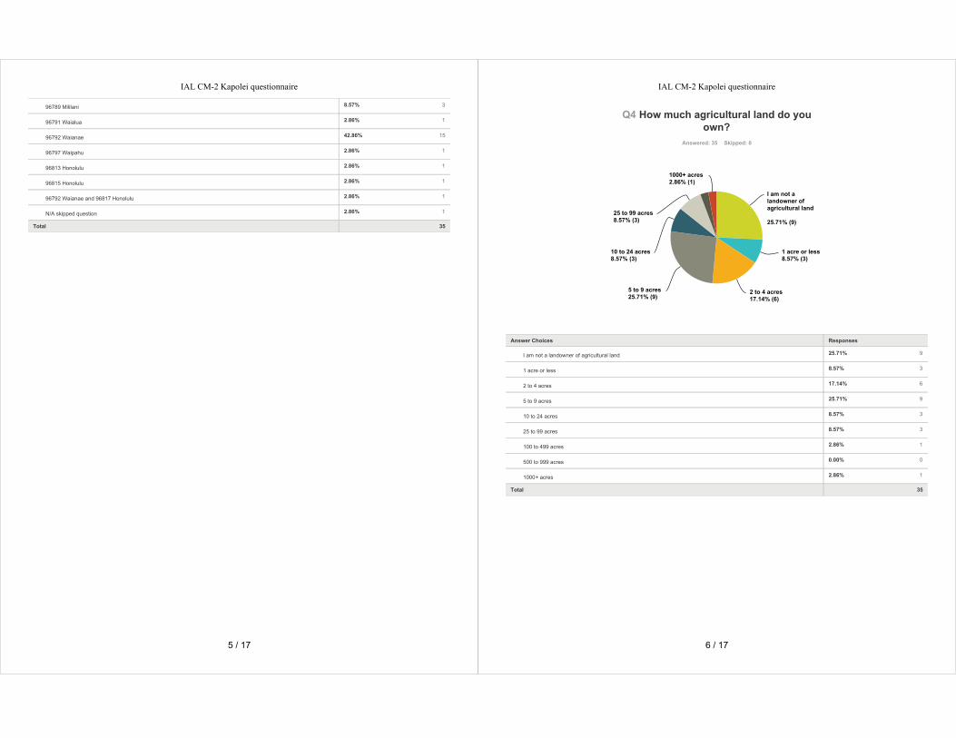

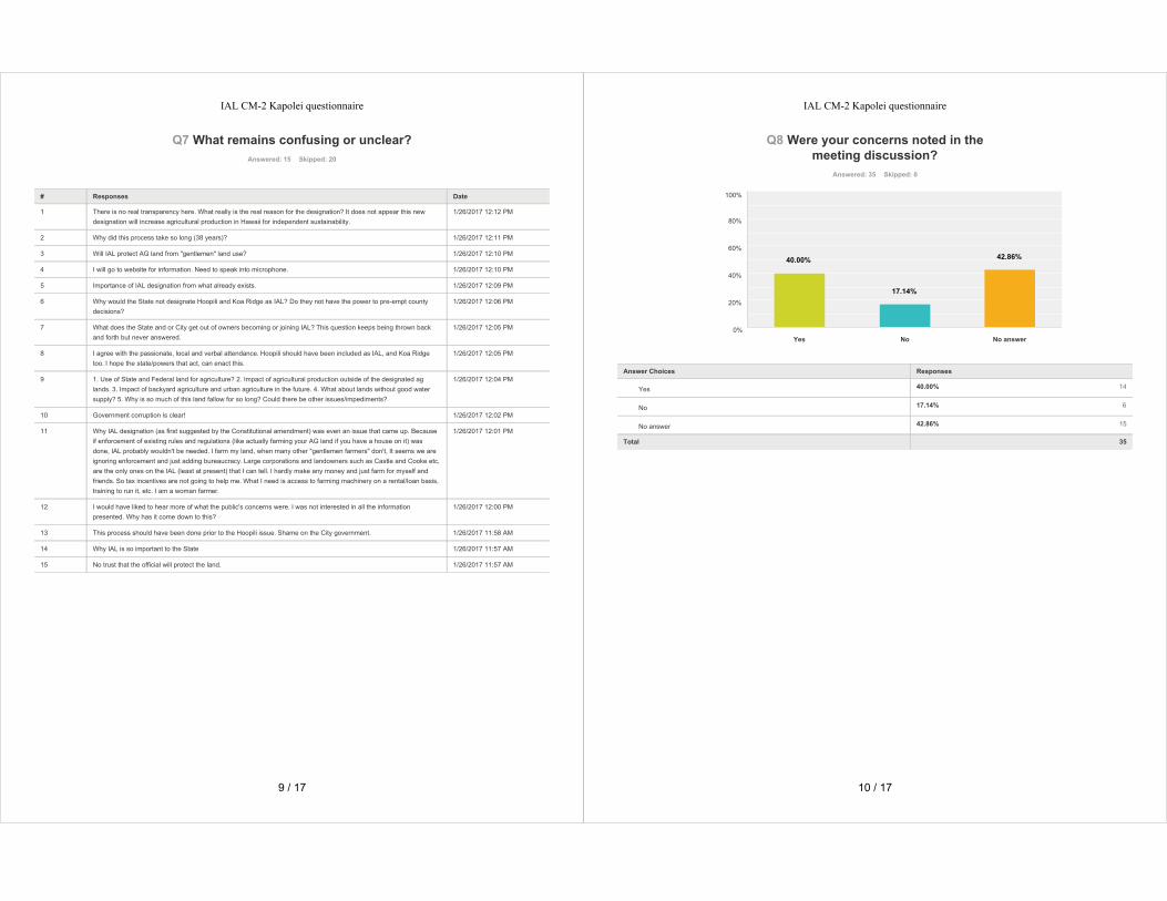

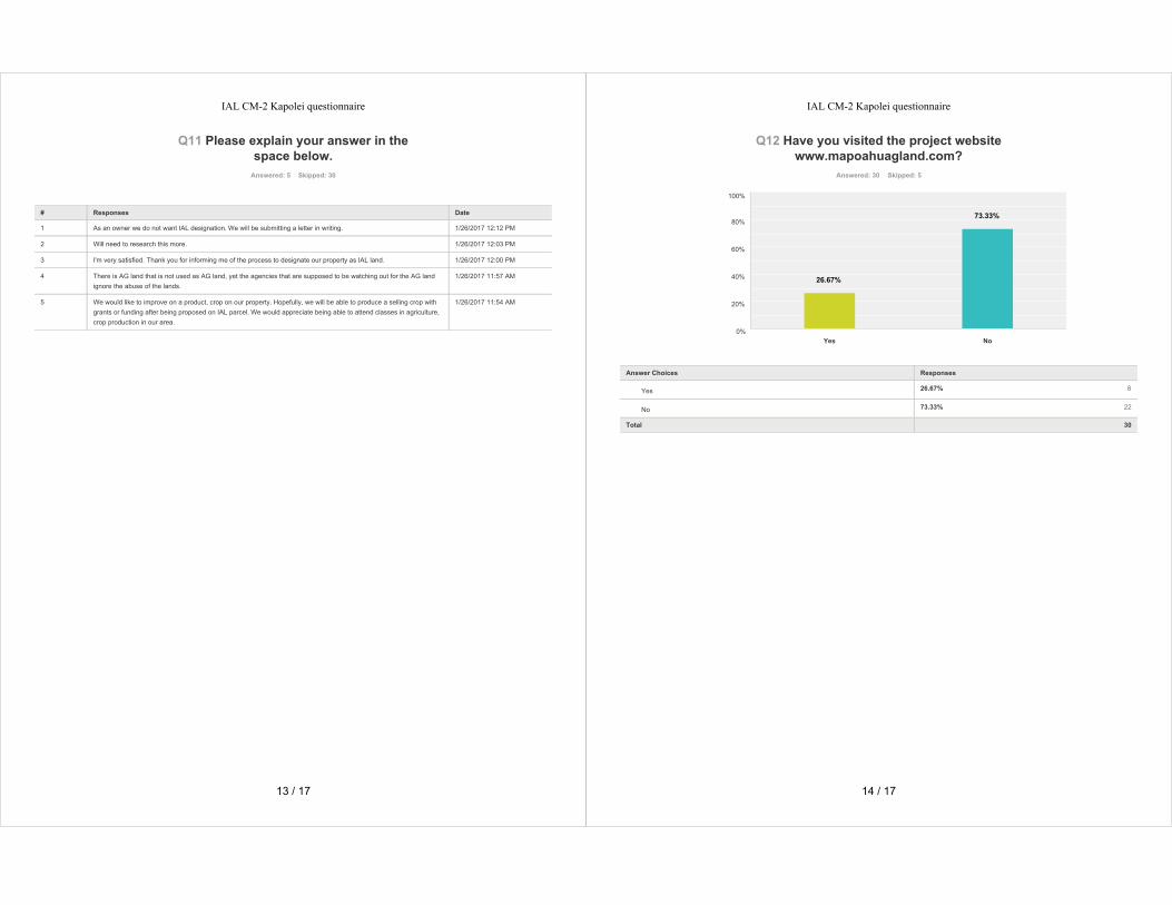

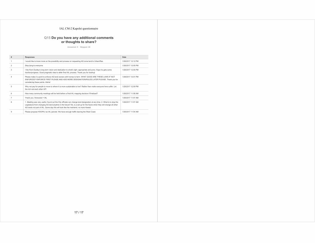

Pacific Guardian Center 733 Bishop Street, Makai Tower Suite 2590 Honolulu, Hawai‘i 96813
Meeting Date: Tuesday, January 17, 2017
Meeting Time: 6:00 8:30 PM Project Name: O‘ahu IAL Mapping Project
Location: Hale‘iwa Elementary School Cafeteria Recorded by: Corlyn OrrReviewed by DPP: February 16, 2017
Attendees: see attendance record
Subject: Community Meeting 2
This community meeting for the City’s Important Agricultural Lands (IAL) Mapping Project was held atHale‘iwa Elementary School Cafeteria on Tuesday, January 17, 2017. This was the second of twomeetings to present the Draft IAL maps and explain the project.
WELCOME, INTRODUCTIONS, AND PROJECT BRIEFING
Kathy Sokugawa, Acting Director of the Department of Planning and Permitting (DPP) called the meetingto order at 6:30 PM, and offered welcoming remarks. Scott Ezer, meeting facilitator, then proceeded toshare background information about himself, and introduce DPP staff and the planning team. Scottexplained that lands approved for the Ho‘opili and Koa Ridge developments could not be considered forIAL designation, and then proceeded with the project briefing.
Following the presentation, Scott introduced several public officials, including Senator Gil Riveire,Representative Sean Quinlan, and Earl Yamamoto, Planner from the State Department of Agriculture.
QUESTION AND ANSWER SESSION
Meeting participants were asked to submit their questions in writing. Scott read each of the followingquestions out loud and provided a response. Both the questions and responses have been documentednearly verbatim to maintain both the accuracy and authenticity of the statement. Due to meeting timeconstraints, not all of the questions were answered (SEE ATTACHMENT A for questions/responses thatwere not answered during the meeting)
1. Why is the P p kea community, a primarily residential community, considered as a candidate forImportant Agricultural Land designation?
RESPONSE: All of the land at P p kea is designated—is zoned—Country by the County. Country allowsagricultural use and residential use. The land is all in the State Agricultural District, and a decision wasmade by the City Administration to include the P p kea lands in IAL. I want to emphasize that gettingan IAL designation will not change the manner in which you enjoy the use of your property. The maindownside to being designated IAL is that if you want to take your agricultural land and zone it forresidential use—like you need to go to the State Land Use Commission or you need to get a SustainableCommunities Plan amendment or a zone change—instead of a simple majority on that vote, you need atwo thirds majority. IAL is not zoning. It’s an opportunity. It’s a category of agricultural land that allowsa landowner to take advantage of incentives.
2. I have land that was purchased by my grandparents over 60 years ago and never used for farming.Why am I being forced to now use it in such a fashion?
RESPONSE: You don’t have to use your land for agricultural purposes if you’re designated IAL. You cancontinue to use your land as you currently use it.
MEETING SUMMARY
O‘ahu IAL Mapping ProjectCommunity Meeting 2, Hale‘iwa Elementary School | January 17, 2017Page 2 of 20
3. What happens to my rental units on this property?
RESPONSE: If the rental units were constructed legally, and they’re there in a manner that was doneproperly, there will be no change to the use of your rental units.
4. When they purchased the property, it was “Rural Protection.”
RESPONSE: That’s something that goes back to the 1950s and 1960s. We don’t have that categoryanymore.
5. What criteria will be used when granting the tax break for farming IAL lands?
RESPONSE: If you make investment in your property and you feel you can take advantage of the IAL taxcredit, you fill out the form prepared by the State Department of Tax. You fill it out and you submit it.The conversation occurs between the State Tax Department and the State Department of Agricultureabout whether or not your request should qualify for the tax credit. That’s how that occurs.
6. How would you guard against someone trying to game the system?
RESPONSE: Interesting question. I think we have to rely upon the folks at the Tax Department and theDepartment of Agriculture to make sure that it’s a legitimate request.
7. If land becomes IAL, how does it affect the resale of my home?
RESPONSE: There should be no change to the value of your property. As I said, you will be allowed tocontinue the use of your property that you currently enjoy.
8. If it becomes AG land, must it be used for AG?
RESPONSE: I answered that. The answer is no.
9. What happens if only half the property is designated IAL, if it’s AG/Residential?
RESPONSE: The area that is identified for IAL does not necessarily include the entire property. There aremany instances when the IAL boundary only includes a portion of the property, so in that instance, theincentive would only be usable for that portion of the property in IAL.
10. How does rezoning affect future building on the land?
RESPONSE: Again, this is not zoning. You can still develop and build as you would under the existing AG1 or AG 2 zoning.
11. Is there an option for private landowners to “opt out” or refuse IAL designation?
RESPONSE: If you do not want to be part of the process, we encourage you—and I believe there’sinstructions in your hand out and there are also instructions on the FAQ on the website on what youneed to do—to let DPP know you do not want to be in IAL. You have to give a good reason for not beingin IAL, and it may or may not be granted, but you do have a right to ask to opt out. The process is in yourhandout, I believe, and the process is also in the FAQ that’s on the website.
12. Are there maps that depict State and County AG lands?
RESPONSE: The maps that we have on the wall show the land that is owned by the State in the AGDistrict. We do not have any printed maps of county owned lands.
13. Too large of disparity between private and government lands proposed for IAL.
RESPONSE: As I said before, this process is not intended to include government lands.
O‘ahu IAL Mapping ProjectCommunity Meeting 2, Hale‘iwa Elementary School | January 17, 2017Page 3 of 20
14. How do I know if my land is designated IAL?
RESPONSE: If you received the letter in the mail from DPP that said your land is being considered, that’show you know. We mailed out almost 2,000 notices to landowners throughout O‘ahu informing them oftheir potential designation, and the meetings and the process that we’re going through today.
15. How will the IAL designation affect farm dwelling permitting for land already designated for AG?
RESPONSE: It would be the same process. You have to get a building permit for a farm dwelling, and youwould be held to the responsibility of the law that says your unit is a farm dwelling. That’s for bothcounty and state law.
16. What am I able to construct on my IAL property?
RESPONSE: Anything that’s allowed. If you’re zoned AG 1, whatever’s allowed in AG 1. If you’re zonedAG 2, anything that’s allowed in AG 2. If you’re zoned Country, whatever’s allowed in Country. Thesame rules apply even with the IAL designation.
17. I pay over $1,000 an acre for property tax. Will the County reduce my taxes once my property isrezoned IAL?
RESPONSE: Probably not. There’s a process where if you dedicate your land to agriculture, you get asignificant tax break from property tax. So, if you’re IAL and you’re not farming now, and you want tofarm, you can do that. You can get your incentives, and you can ask for the tax break from the realproperty folks.
18. Are the “benefits” on a first come, first served basis?
RESPONSE: No.
19. Do smaller, poorer farmers receive benefits before larger landowners?
RESPONSE: Doesn’t matter how big or large your land is. Doesn’t matter how rich or poor you are. Ifyou’ve got the designation and qualify for the incentives, you’re entitled to it. Castle & Cooke is entitledto the same process as somebody who owns one acre or less, and there are some properties that are lessthan one acre that are being proposed for IAL.
20. If land has voluntarily been placed in AG Preserve for a number of years, will it still go into IAL ifit’s on the map for IAL?
RESPONSE: Yes.
21. Can you include more small farmers and family farm landowners in your planning?
RESPONSE: Not sure what that means. Whether you thought they should be included in the process orin IAL? When we first made the map, we were blind, we didn’t even look at property lines. We didn’tcare how big the property was. We didn’t care who owned it. We just looked at the physicalcharacteristics of the property and mapped those attributes.
22. From the presentation, small farmers were not represented well. Only one person on the listconsulted.
RESPONSE: We had 11 farmers, and many of those farmers were small farmers that did own theirproperty. The landowner that was represented on the advisory committee represented a number of thelarge landowners. Instead of having five large landowners, we had one representative for that group.
O‘ahu IAL Mapping ProjectCommunity Meeting 2, Hale‘iwa Elementary School | January 17, 2017Page 4 of 20
23. I purchased a property located on Hale‘iwa Road next to a bridge. There’s an existing structure onthe property and there’s also a ditch that runs in the middle. The land is unproductive at itspresent state because it gets flooded with brackish water when the river overflows and when itrains hard. In order to make it productive, massive truckloads of soil have to be brought in. Theproperty is also next to a residential zone. Can my property be excluded as an IAL?
RESPONSE: I recommend highly that you get in contact with Tim, and discuss your situation with him.
24. I believe it is important to use our good farmland properly, but as much as I want to help thateffort, I have no guarantee that later on the State can use IAL status to somehow encumber myproperty with more rules to make it harder to farm as a small farmer. Can you reassure me thatthis will not happen in the future?
RESPONSE: In my heart of hearts, I can’t see that happening, but I can’t predict what may or may nothappen in the future. This legislation is intended to increase productivity, increase farming, increase theuse of the land, and not to penalize any landowners, in particular small landowners.
25. What are the reasons besides non suitable soil quality will be adequate reasons that IALdesignation can be opted out from?
RESPONSE: It’s not farmed, it’s never been farmed, the soils are bad, you have no water, you don’tintend to ever farm, it’s a small property, it’s isolated. There’s a number of different characteristics thatyou might qualify for. But again, each individual situation is unique, and will need to be discussed.
26. I, and another family, have a 5 acre AG land lot with a “CPR.” None of the other lots can bedeveloped as “family” farms, meaning no other dwellings can be built until the land is changed—ithas to undergo some permitting at the County. Will the IAL designation make it harder for theother families to build, to get “site development” status?
RESPONSE: IAL designation should not interfere with the lawful use of your property, whether it’s as aCPR, or as a subdivision, or anything else. There are rules on how many homes you can have on anysingle agricultural property, which is three. If you’ve already reached the maximum number, you can’tput in anymore.
27. I believe Hawai‘i has a unique farming problem in that the land is incredibly expensive. Why was“affordability” not given any concern in the identifying criteria?
RESPONSE: I didn’t draft the legislation, so I can’t speak for the folks that did that.
28. If only large landowners and corporations can really afford farmland, should that not be part ofthe IAL as your list has provided or be part of the sustainability plans or the IAL plans?
RESPONSE: The reason that mostly large landowners have taken advantage of IAL to date is because aslarge entities they’re looking out to the future, they’re ahead of the curve. There’s also a provision in theIAL law that says, if you’re a landowner—it doesn’t matter how large or small—if you voluntarily putyour land in IAL and more than 50% of your land, of all the land you own on O‘ahu, is put into IAL, exceptany land that you own in the State Conservation District, this process cannot touch the rest of your land.So in fact, that is what Kamehameha Schools did. They took over 50% of the land that they own onO‘ahu, and dedicated it—put it into IAL—so the rest of their land is excluded from this process. TheRobinson Family Partners did the same thing on Kaua‘i. A&B on Maui, Parker Ranch on the Big Island—they put land in IAL and whatever happens with the rest of the counties, they cannot be put in IAL.

O‘ahu IAL Mapping ProjectCommunity Meeting 2, Hale‘iwa Elementary School | January 17, 2017Page 5 of 20
29. Since the inducements for voluntarily allowing your land to be IAL are only tax breaks whichrequire farmers to be making a substantial profit, will you consider other types of inducementsthat will actually benefit small farmers? Only large landowners have voluntarily designated theirland as IAL. There are also classes being offered, but these are already farming classes that arecurrently being offered.
RESPONSE: As I said before, it doesn’t matter whether you’re making a profit or not. If you make aninvestment in your property, you’re eligible to take that investment as a credit.
30. Once the IAL designation is made, how “iron clad” is the protection?
RESPONSE: You can always petition to come back out, but it’s a lot harder to get out once you get in, soit would be considered fairly iron clad.
31. And then they go on to say, can it later be changed—like for Ho‘opili?
RESPONSE: I think I made myself clear on how the law treats Ho‘opili.
32. Once the IAL mapping is done, what steps would be implemented to prevent a futureadministration from bulldozing it and rezoning the AG lands for more urban growth?
RESPONSE: As I mentioned, there’s a whole hierarchy of law. You have to start at the State Land UseCommission, you actually have to start with the North Shore Sustainable Communities Plan because ifyou’re not consist within North Shore Sustainable Communities Plan, you can’t go to the State Land UseCommission and your North Shore Sustainable Communities Plan makes a very strong statement aboutagriculture and its vitality and your desires as a community to keep the North Shore in agricultural use.I’m very proud to say that my firm—and myself and Cory—were the lead planners for the North ShoreSustainable Communities Plan that was adopted by the City Council in 2010, working with many of yourfriends and neighbors.
33. Given reasonable assumptions about agricultural productivity, how much land would be requiredto feed O‘ahu’s population if imports stopped?
RESPONSE: I’m sure you’ve all heard the seven day rule, or many of you have, that the stores that wehave, our grocery stores and markets, only have seven days of food. So what happens if there’s somekind of a catastrophe and we cannot import? I’ll tell you right now, we import about 90% of the foodproducts that we consume on O‘ahu. We are able to produce about 30 35% of the fresh produce that weconsume on O‘ahu. With respect to things like eggs, milk, meat and other specialty items, those are allimported. People always want to know, how much land do we need? Today there are approximately40,000 acres of land that are zoned for agricultural use on O‘ahu that are fairly good AG lands that arevacant and are not being farmed. So the question is, how do we get people on the land to farm those40,000 acres? And I think that’s one of the biggest challenges we face has an island community. Toensure that there are people that come with us and behind us that want to farm, because if nobodywants to farm, we don’t get food.
34. Why did you NOT include Ho‘opili and Koa Ridge in this?
RESPONSE: I already explained that.
35. Can an IAL parcel that consists of organic farming have a legal right to protect them from pesticidespraying by surrounding neighbors who share common boundaries?
RESPONSE: IAL is silent on pesticides. The State laws and rules governing the use of pesticides wouldprevail.
O‘ahu IAL Mapping ProjectCommunity Meeting 2, Hale‘iwa Elementary School | January 17, 2017Page 6 of 20
36. Why do we need to identify important AG lands? ALL AG lands are important.
RESPONSE: Yes they are.
37. Are you really going to listen to the people, or are you going through the motion?
RESPONSE: A lot of you know me, a lot of you don’t. I’ve been in this business for almost 40 years. I’vebeen a practicing planner in Honolulu since 1978. I worked for government. I’ve been in private sectorfor 29 years. I worked on the North Shore Sustainable Communities Plan, the Ko‘olau Loa SustainableCommunities Plan, working on the General Plan Update, I’m working on this. I’ve represented a numberof government agencies and private landowners with planning advice. I will let my reputation speak foritself and we are not going through the motion, and we do consider seriously all of the comments thatare submitted.
38. Are you going to respect the O‘ahu General Plan to keep Ko‘olau Loa and the North Shore rural?
RESPONSE: I believe this question is probably geared for the Ko‘olau Loa Sustainable Communities Plan(SCP), and like you I read in the paper—perhaps yesterday—that Councilmember Ikaika Anderson hasannounced that he will be moving the Ko‘olau Loa SCP forward without the Envision project included inthe SCP.
39. Who’s on the IAL advisory panel and how were they picked?
RESPONSE: We spent a number of meetings with the City Department and the agricultural liaison for theCity. We went through a list of over a hundred people that were farmers, people in the industry, peoplethat contributed to writing the IAL law. We had two of the original drafters of the IAL bill on our advisorycommittee, so there was a collective decision making by a number of people and that was how theywere selected.
40. What are the names of the technical committee?
RESPONSE: They are posted on the website. You can see who they are by looking at the minutes.
41. If land is designated IAL, then taxation and utilities should be discounted to the landowner.
RESPONSE: There is already an opportunity for taxation. Utilities—if you are on the City potable watersystem and you are using potable water for AG use—you get a tremendous discount in the use of water.
42. Pay attention. Don’t make government an issue like in Nebraska, Oregon and Nevada laws, likeincidents like GOVT vs. PEOPLE violence. Issue of legal rights to property.
RESPONSE: We’re not trying to restrict people’s use of property.
43. How does this process work with the North Shore Sustainable Communities Plan yet to beimplemented?
RESPONSE: The North Shore Sustainable Communities Plan, as I mentioned, was updated in 2009 and2010 and adopted by the City Council at that time.
44. Does HFDC have the ability to supersede these determinations?
RESPONSE: HFDC is a State agency, and would be under the review of the State Department ofAgriculture.
45. Will IAL designation help prevent or make enforcement easier of illegal vacation rentals?
RESPONSE: I don’t think it will make it any easier. The City is trying to do what it can. IAL has norelationship to that.

O‘ahu IAL Mapping ProjectCommunity Meeting 2, Hale‘iwa Elementary School | January 17, 2017Page 7 of 20
46. For landowner initiated IAL, wouldn’t it be a great incentive to lock property taxes permanently atthe present rate?
RESPONSE: It’s a good suggestion.
47. Do you have maps of areas using R 2 recycled water, especially for Wahiawa toWaialua/Hale‘iwa?
RESPONSE: I’m not sure if we do, we might. If anybody does have those maps, I would like to see them.
48. Is the prime AG lands currently designated for Ho‘opili development in the IAL designated area?
RESPONSE: No.
49. Why would the State not include the state land that is leased to farmers?
RESPONSE: They should and they need to get on their program to identify State owned AG land. I haveno control over what the Department of Agriculture and the Department of Land and Natural Resourcesdoes.
50. What percentage of O‘ahu’s lands are in each of the following zones: Urban, Agriculture,Conservation, Rural?
RESPONSE: Conservation is 41% of all land, AG is 33%, Urban is 26%. (NOTE: O‘ahu has no Ruraldesignated land.)
51. This community has resolved to define local food production for local consumption as the highestpriority for agricultural land use. How does the current outline for IAL reflect the community’sdesire that AG land be protected for local food production?
RESPONSE: The law is silent on how the land is to be used. The purpose of the project is not to tellpeople how to use land, or how to farm, or what to farm. The purpose of the project is to identify theland that is the best AG land and let people make their own decisions about what to raise and whatcrops to raise.
52. P p kea is zoned Country and some properties are AG.
RESPONSE: I think I already answered that.
53. Wouldn’t it be better by the 3 criteria, not to water down the “Important” part of the IAL bylumping it all together whether 1, 2, or 3 criteria are met? A better solution may be to haveseparate designations: IAL 1, IAL 2, and IAL 3.
RESPONSE: That’s an interesting proposition. Again as I mentioned, the consideration by the CityAdministration was to be as inclusive as possible and include as much land in the IAL designation as theycould.
54. If you do not want to be IAL, must you write to DPP before March 31, 2017?
RESPONSE: I strongly recommend that.
55. AG land farmers have certain production requirements. Are these requirements for production orother requirements tied to IAL?
RESPONSE: No.
56. Will I lose my “Country” zoning status if my land is made IAL?
RESPONSE: No.
O‘ahu IAL Mapping ProjectCommunity Meeting 2, Hale‘iwa Elementary School | January 17, 2017Page 8 of 20
57. There is a stream on my property. Isn’t the easement sufficient for assisting farming efforts?
RESPONSE: I’m not quite sure what question is. If you come see me after, I’ll try to help you.
58. Is there a cap on the tax credit, a percentage limit for IAL tax credits?
RESPONSE: No, it’s a dollar value.
59. Is funding for the IAL incentives already set aside or will funds need to be incorporated into futurebudgets?
RESPONSE: As I mentioned, the tax incentive is scheduled to sunset December 31 of this year. It’simportant that it be extended and the Department of Agriculture is working to make sure that happens.
60. How will a property being CPRed as County and now designated IAL be affected?
RESPONSE: It should not be affected.
61. What are the restrictions for employee housing under IAL?
RESPONSE: My recollection is you can only use 5% or 50 acres of the land, whichever is less, and thenyou would be limited to the number that would be allowed under the AG zoning.
62. Can I charge rent to my employees?
RESPONSE: Yes.
63. Can I charge part time employees rent?
RESPONSE: Yes.
64. How many housing units can I build for employees?
RESPONSE: I just went over that.
65. I currently am required to “dedicate” my AG land for AG use every 10 years. Will this still berequired as IAL?
RESPONSE: No, IAL will go on. The tax break for AG dedication will still be on the 10 year cycle.
66. How vulnerable does IAL leave a property to “eminent domain?”
RESPONSE: For those of you that don’t know, eminent domain is the power of the government tocondemn property for public use. If the government wants your land, and there’s a public purpose forwanting your lands, and they want to buy it, they can go through eminent domain. They can’t—theydon’t just get it. They have to pay you the market value for the property. IAL will have nothing to dowith eminent domain.
67. The IAL designation allows 15% of the AG land to be rezoned for urban or residential use. Will this15% rezoning clause be allowed for all this IAL identified properties?
RESPONSE: You only get the opportunity for that 15% clause if you voluntarily dedicate your land to IAL.And then only the land that gets the special processing has to already be set aside for urban use.
68. Is Castle and Cooke with 679 acres paying only $300 per year property taxes?
RESPONSE: I have no idea.

O‘ahu IAL Mapping ProjectCommunity Meeting 2, Hale‘iwa Elementary School | January 17, 2017Page 9 of 20
69. Where does the IAL designation go if accepted/granted? Owner’s title report?
RESPONSE: Not sure. It would be identified by City land use records, and I’m not sure whether it wouldbe included on your title report.
70. If the land is farmed and becomes productive, how will the government help in selling theproducts?
RESPONSE: Well, there’s a number of different things going on. I know the State Department ofAgriculture funds, supports, and encourages many programs to buy local. We see the benefits of thatprogram on TV all the time. Most of our farmers markets are restricted to locally grown products.There’s a rising consciousness of all people who live on O‘ahu to buy local products. When we initially—we had some focus groups for this project—we had some members of the retail grocery industry, and weasked them this very question. What kind of percentage of local products do you put on your shelves?These were all the big name grocers, and they said, “You know, we try we try to have about 30 to 40% ofour produce locally grown by local farmers. We could double that. We just can’t get our hands on theproduce.” And people are willing to pay more to buy local. That’s been shown. There’s been studies andthe grocers support that and understand that. The question is getting production out of the land, andgetting those products out of the ground and into groceries.
71. Will you have a designation for organic land?
RESPONSE: No, we aren’t going to do that.
72. How many of these planners worked for Monsanto?
RESPONSE: Zero.
OPEN FORUM
Meeting participants wishing to speak during the Open Forum were asked to sign up in advance ofspeaking. Each speaker was given two minutes to speak. Those wishing to speak longer than twominutes were invited to sign up for a second turn, after all others had a chance to speak at least once.Each speaker’s comments have been documented nearly verbatim to maintain the accuracy andauthenticity of their statement.
1. Herman Ferreira: With all respect to everybody in this room, I come from Waiahole Waikane. Icouldn’t understand why I received a map in the mail that this small portion of Waiahole Waikane isincluded in this project. I don’t understand because some big land developers in the back ofWaiahole bought all this property to plant cocoa beans and all of this stuff, and it hasn’t gonethrough. The water tunnels that move all of the water from Punalu’u to the opposite side of theisland goes through Waiahole. I don’t understand, maybe the Director can say this, why a meetingwasn’t held in Waiahole Waiakane. People keep asking about tax rates. I going tell you somethingabout tax rates. I’m a small landowner. If you do not designate, if you do not use your land totallyfor farming—like me I’m retired and now I farm on my land, I raise livestock and I raise goats—youdon’t get a tax break. I’m talking about property tax. Everything, all these other incentives that youget, you do not get the tax break. Maybe the politicians in this room can check up on that and let usknow why is that. I used to have my land dedicated to farming. Now he said earlier, we get water,discount on water. Once they take away that break that you do not dedicate your land totally forfarming, you do not get those deductions. I was paying $2,000 a year for taxes, now I pay almost 5.With the homeowners insurance and *the property tax, its out of control. But like I said, maybe Mr.Rivera—I voted for you by the way—maybe you guys can check it. Because it’s not fair. I don’t think
O‘ahu IAL Mapping ProjectCommunity Meeting 2, Hale‘iwa Elementary School | January 17, 2017Page 10 of 20
it’s fair at all. Thank you for your time. Two minutes is not enough. It’s sad, really is. Verydeceiving.
2. Dawn Wasson: Aloha. I’m Dawn Wasson, kou inoa. I’m a kupuna from Laie wai. I’m here tonight toobject to this process because this process is dictated to you and taking away your rights as to theuse of your land. And I want to give these people notice now that I will definitely apply at acontested case hearing. I don’t know if many of you guys know, but today is the overthrow of theHawaiian Kingdom, and I would like all of you to stand as we sing Hawai‘i Ponoi. Please, Hawai‘iPonoi. (Everyone stands and sings). Mahalo. For all of you, I want to say thank you for your loveand respect for the kanaka, the people of this land. I speak as a kuleana and konohiki landowner.My families has been in Laie for 212 years. We have been diligent in protecting our lands, and wehave been under attack since then. But to all of you, if your land is kuleana land, you have a taxbreak of $300. Look it up. Make use of it. But I say to you, look up this chapter of the Land UseCommission, Section 205 43 all the way to 51. Do not give up your rights, do not allow any of thesestate agencies or city agencies to dictate to you how you are able to protect your land. It is yourright. So please, aole makau, do not be afraid. Stand strong together as one, and do not let themtell you what you should grow on your land and how much, because they are going to confine usinto this different criteria. You have to have a business plan, you have to have a business license.We’re talking about self sufficiency. Your land, you grow your own food and eat your own food, andif you want to sell it, you don’t need their permission. So love to all of you. Mahalo.
3. Thomas Shirai: January 17, 1867….Today, 150 years ago, my great great grandfather was born. Ifeel that when you do something of this magnitude, you need to go to each specific area. There aresix moku on this island. You need to go to each moku and address specifics so that you don’t wastetime. Also, I do have concerns about some designated areas and stuff like that, but what got mewas, you know just like they have the Land Use Commission at the state level, I feel they shouldhave a Hawaiian cultural practitioner representing the Hawaiian culture. You need to have thatbecause it is not just maps. I did my genealogy. It cost me $0.15 to find this page. Fifteen cents, not$200 an hour, or so many thousand dollars for getting the same thing. And in that $0.15, I found myancestors name, I found his occupation, which was farmer or taro farmer or fisherman, and hisgeographical location. More than a person that is trained as a consultant with no such feelings.They will go away after that contract is done, but this will be passed on for generations andgenerations and generations. So, I hear the signal, and the most positive thing that I can see tonightis—I’d like to see everybody, regardless if you like IAL or you don’t like IAL—please be civil.Especially when to come to somebody’s house. Please be civil. It’s alright to disagree, but bemindful and respectful. Thank you.
4. Patricia Beekman: I’m here for Ho‘opili. Ho‘opili has been put to side and is not considered in theIAL. Ho‘opili and Koa Ridge are important. Ho‘opili is the best agricultural land on the island, and itproduces about a third of the produce that we buy at the local markets. I talked to a professor—Dr.Goro Uehara—and his specialty was soil analysis. He said that the Ho‘opili farmland is the best inthe country, I think he might have said the best in the nation and it’s the only quality agriculturalland of that stature on the island and this is what’s going to be paved over for development. It tookthousands of years to have this quality of land available to us, and once it’s destroyed, it’s notcoming back. A lot of us want to keep fighting until the very end to save Ho‘opili. It’s important tous as a people. Hawai‘i is the most isolated, populated area in the entire world. We get things fromthe mainland, that’s 2,500 miles just to California. What’s going to happen if there’s war, or somekind of disaster happens and we can’t get food from the mainland? We’re going to be in big troubleand that’s because of the shortsightedness of our politicians. Our political system is corrupt. One

O‘ahu IAL Mapping ProjectCommunity Meeting 2, Hale‘iwa Elementary School | January 17, 2017Page 11 of 20
example of corruption is the City Council. I attended the last meeting at the City Council where theyall voted to rezone the Ho‘opili farmland to Urban so that it could be developed, and none ofthem—even though there were many of us that were talking about the importance of theagricultural land there—none of the City Council members mentioned any objection to the farmlandbeing destroyed forever. And so we were going out of there saying, we can’t believe it. All of themvoted to rezone this. Well it came out later that all of them are getting campaign contributions fromdevelopers. The amount of contributions ranged from about 42% to about 88%. I’m getting wavedoff, so my time is up.
5. Choon James: Aloha, just a few points. I’m Choon James from Kahuku. I find it really inconsistentthat this project here, this process here, will respect home rule when it comes to agriculture, wellwhen it comes to Ho‘opili and Koa Ridge, but the lawsuit about the pesticides in Maui and Kaua‘i,they did not give any credit to home rule at all. To me that’s a very inconsistent application of cityand state ordinances and law. May I also say that all AG lands are important? All AG lands areimportant. Also, he had mentioned that there were 40,000 acres that were not farmed or that areso called fallow. Well, most of these 40,000 acres are owned by big corporations and these landsare not farmed because they’re under lock and key. Right? People cannot get to it because it’s lockand key, and most of it is owned by big landowners. I also want to add that I still have questionsabout them not wanting to respect the O‘ahu General Plan. So my question is, if I have 1,000 acres,does that allow me to set aside a certain amount of development in an area that may contradict theO‘ahu General Plan. My question also was, are you going to listen to the people or are you going togo through the motion? It happened to us in the Ko‘olau Loa Sustainable Communities Plan. Therewere 25 members working on it, and at the very end, the development on Gunstock Ranch was justput in. Despite our protests, it was just put in. I hope this process would sincerely include thepublic, instead of just going through the motion. Thank you.
6. Michelle Tomas: It’s no secret that my grandsons and I have been to the City Council many a times,testifying before them about Ho‘opili. My family roots go deep when it comes to farming in theislands. My mother in law was the daughter of one of the first wave of sakadas that was brought tothe islands from the Philippines. She died when she was 95. Members of my family currently havefarmland here in Waialua so my roots are deep. In the soil. Koa Ridge and Ho‘opili actually set theprecedent for all of our farmlands to be rezoned. And we have to understand that. It’s a challengeto all the landowners out there to speak out loud and proud and preserve your own land, and bevigilant. My grandsons coined the phrase during the time they were testifying before the CityCouncil—we can’t eat concrete. At that time they were ages eight and nine. And they already knewwhat the land meant to them and what it still means. When that vote came down, they werecrushed. They said we cannot trust the government now. Look what they did to the best farmlandin the state. That’s coming from our children. We are led by our children. They are our future.Think about that. We do this to preserve all this land out here from development. The precedenceis already there for big landowners to come in and take it from you. You have to be vigilant. If it canhappen out in ‘Ewa, it can happen anywhere. So please, speak up loud and proud, attend everymeeting you possibly can, pack it even bigger than this because your voices have to be heard. Thankyou.
7. Dr. Kioni Dudley: Aloha. I’m Dr. Kioni Dudley. I’d like to tell you that I’ve been very much involvedin Ho‘opili since the very beginning. I want to correct you about the situation as far as the law isconcerned. It is true that the state law says that you should not include areas that are designated bythe counties as urban or to be urbanized. However, when we take a look at what happened here,Kathy Sokugawa who’s the acting head of DPP right now and I were at that meeting of the City
O‘ahu IAL Mapping ProjectCommunity Meeting 2, Hale‘iwa Elementary School | January 17, 2017Page 12 of 20
Council in 2012 December, and we were considering whether or not to put Ho‘opili and Koa Ridgeinto the study. Now everybody at the Council knew that this would be contrary to the law becauseKathy was there and told them so, and that’s on the record. That was taped by Olelo and it’s stillavailable for people to see. The City Council took Kathy’s work, ok, the law says this, but we madethe designation about what was going to be urbanized. We made that designation. We at the CityCouncil, and we are saying in this resolution, in spite of that—because Kathy brought it up—in spiteof that, we want you to study Ho‘opili and Koa Ridge and put them in this study. They’re not sayingthey’re going to prevent it, all they said is, we want them in the study. I understand I get 2 minutesif I come back at the end. Please stick around. I have a lot more to say. Thank you.
8. Raymond Arancon: Listening to this presentation that was presented got me all frickin’ confused.Messed up my mind. So now I think I need more than two minutes because you have to explain tome, you know, you have to explain out the confusion that you instilled in my brain. OK. Now DPP,City Council, Land Use Commission, Legislature, Courts—they’re all part of the State government,right? Is that correct? OK, they’re part of the State government, yes? (Scott responds, State andCounty government.) Ok, so that means that they’re governed by domestic law, municipal law,domestic law. Because your presentation stated over and over, you have to comply with State law,compliance of State law, State law, ok. So now that means the rule of law. So now I need to havethis confusion cleared up. My question is this. Number one. In 1993, Congress passed the PublicLaw 103 150 called the Apology Bill, and Congress stated, the United States said, we screwed up.We illegally overthrew the Hawaiian Kingdom. Now, because of that, yeah they want to take overall of this land and stuff, but we screwed up. Now, because of that, number two. Congress passedPublic Law 104 192 in 1996 after 1993 the Apology Bill. They incorporated that public law with Title18, US Code Section 2441, Chapter 117. It’s about war crimes and it resulted from the Apology Billand the illegal occupation. Number three. The International Court on February 5th, 2001, in thearbitral award with Larsen vs. Hawai‘i case, in the International Court, they acknowledged andconfirmed the Hawaiian Kingdom’s sovereignty, continuity and its still existence. That’s InternationalCourt, 2001 February 5th. Now this comes even more stunning. March 5th, 2015 in the court ofJudge Joseph Cardoza, in his criminal case 14 1 08 19, 14 1 08 20, he issued a judicial noticeconfirming the existence of the Hawaiian Kingdom. A judicial notice in a court here in Hawai‘i ,Judge Joseph Cardoza. Now my question is this, because of all this confusion—we have to followthe law, follow the law—if that’s the case, this hearing demonstrates two things. One, a strongignorance of the rule of law, and two, a high disregard for the rule of law. So now, explain to me.How can this meeting take place because it’s violating the rule of law? The State constitution says,preservation of important agricultural lands to be kept in perpetuity. Perpetuity—that meansforever but what the hell….These guys……
9. Carol Philips: Good evening everybody. I always got to follow the hard act. It’s so wonderful. Ihaven’t seen this many—I like to call you guys freedom fighters—but wonderful people together in aroom in a long time, so it’s nice to be here. I’ve been following this important AG land thing for 1015 years, and I just see it as a way to make it easier to rezone about 50% of the AG land in Hawai‘i ,or to upzone it. So that’s really what I think is going on. And the pilikia with Ho‘opili is bringing thatup. This is not about protecting AG lands. This is about making it easier to rezone unimportant AGlands, whatever that means, and I guess that’s just by default. And Scott, I want to commend youbecause I know that you’re going to give your bosses an earful of what you’re hearing, so I’m gladthat you’re facilitating this meeting. I know you’re an honest man so I’m not going after you. Itlooks nice, the North Shore, it looks like we’re getting all these important AG lands but it’s really thequote unimportant quote AG lands that I’m afraid for. Listening to the gentleman talk before me,and saying that AG lands are supposed to be perpetuity—so what about the unimportant AG lands?

O‘ahu IAL Mapping ProjectCommunity Meeting 2, Hale‘iwa Elementary School | January 17, 2017Page 13 of 20
And lastly, someone brought a question up and they said, what was the number of agricultural acresthat we need on O‘ahu to be sustainable when those seven days are up and we don’t have foodcoming in? That question wasn’t answered. It was no one wants to farm. But what is that number?How many acres do we need to have available for agriculture to be able to feed ourselves whenwe’ve got a million people. Thank you.
10. Mary Chun: Good evening. My name is Mary Chun. I agree with Carol. Like she mentioned, we aremost of us here to protect our AG lands. The AG lands behind my house where I’ve lived for the last40 years are in eminent danger. In fact, tomorrow is the City Planning Commission meeting todecide if those AG lands should be turned into, rezoned residential. I live right across the streetfrom the North Shore Marketplace on Kilioe Place, which is a small cul de sac next to Achiu Lane.Mr. Scott Wallace has bought the land behind our homes—15 acres or 20 acres—and he’s proposingthe Hale‘iwa Plantation Village and he’s going in front of the Planning Commission tomorrow andasking them to rezone that AG land into residential. I’m just asking if there might be anybody herethat would like to join myself and my neighbors of Achiu Lane and Kilioe Place on KamehamehaHighway, you know the people that want to protect our AG lands, to go to that PlanningCommission meeting. I’ve never been myself. It’s in Honolulu. 550 South King Street at 1:30 in theMission Memorial Building. It looks like it’s down by Honolulu Hale. And they say if you want togive testimony, you have to bring 15 copies. Or you can go and just support us. We reallyappreciate that. Thank you.
11. Larry McElheny: Aloha, my name is Larry McElheny. I live in P p kea, and I received the same letterI guess several of you folks received. When I read the letter, it started to bring back some memoriesand I started to think about what little I know about the land use law and the history of it here inHawai‘i. As I reminisce, there’s some important milestones. In the ‘60s and ‘70s, Hawai‘iestablished one of the most forward looking land use laws in their country. It was hailed as beingvery progressive, and just a great land use law. About the same time, maybe previously, there weremaps made—ALISH maps, Land Study Bureau maps—that identified all the important AG lands inthe islands, and the quality of those lands. For 20 or 30 years, the land use law served us well. Oneof the primary functions of that law, people don’t realize, was to retain open space and containurban sprawl. So not just about agriculture, but about the philosophy about land use. As I said, theland use law worked very well for years and years. The ALISH maps were referred to in EISdocuments and so on and so forth. There’s plenty of good maps that identify AG lands already. Andthen around plus or minus a few years, around 2005, somebody came up with this great idea,Hawai‘i Revised Statutes 205 42. And so I started asking couple of land use attorneys that I know,what’s up with this? What’s going on with this IAL land program? I’ll just read you some quotes.Now these are people that are attorneys, licensed attorneys, but they don’t work for developers,they work for nonprofits. This is what they said about this program. It’s an attempt to dismantleHawai‘i’s land use law. It offers little or no additional permanent protection. IAL is a joke. Itencourages development outside the urban core via the trade offs. It is very confusing. Is thisintentional? How can land that has residential development be considered important AG land?Why is Ho‘opili and Koa Ridge not included? And so on and so forth. Thank you.
12. Jay Izaguirre: My name is Jay Izaguirre. I’m from Waiahole on the other side of the island. I wasn’teven going to say nothing, but I was born and raised farming. My papa, my mother, my tutu,everybody. To me, it’s just so much. It’s just everybody talking, and you know, it just comes back tofood. Food, and your guys land. I know somebody come to me and telling me something I wouldn’tunderstand, its kind of a lot to take in, but I just do my homework. I still farm. I’m from Waiahole.We have access to water, there’s an auwai on property, thankfully. You guys have what, spring
O‘ahu IAL Mapping ProjectCommunity Meeting 2, Hale‘iwa Elementary School | January 17, 2017Page 14 of 20
water and our water? But I don’t even care. I know all the old timers care, and I respect that, that’show we was born and raised. I’ve climbed through those tunnels. I popped out in Waipio. All I cansay is to the farmers and to all the people, you know, buy local produce. It helps. It puts boots onmy kids, it puts tires on their dirt bikes, you know what I mean? It buys me diesel. I mean, come on.I never heard one thing about diesel. Or you’re talking about how we want farmers. I swear I meantat least 10 guys my age who want to farm. That’s not one joke. All the old people farm. And theybus’. Seven days a week. And I do construction. I didn’t want to talk. I just wanted to say thank youfor the people that buy produce and the people that plant produce because that’s how you goin’ getindependent is money. You need more money.
13. Karen Murray: Hi, my name is Karen Murray. I’m terrible at public speaking. I remember my firsttime I ever spoke in public was at a Waiahole thing. Anyway, I want to show you my sign first off.OK. There’s a difference between prime AG land and land that you use R 2 water. That you have touse R 2 water, or land that you have to pump the water up to. There is a major difference betweenland that doesn’t get enough sun so your crops mildew, that are higher up. There’s a lot of thingsthat go into farming, and that young man was right because I know a lot of young people who wantto get into farming and just can’t get on the land. And it’s hard once they do get on the land to stayon the land. You know, I was a produce buyer at the co op, and I had a friend who was up here, andhe was farming organic, and all his things got stolen. The final straw was when his tractor gotstolen, and the tracks led right to the person that stole it, and the police couldn’t help, and said,sorry there’s nothing we can do for you. I know there’s a lot, a lot of challenges for young farmers.The other thing is this thing, important AG lands vs. unimportant AG land. You know, this wholething just smells. Trying to get around laws, and divide it and sell it somehow as commodities,somehow. I wrote notes ‘cause I’m so terrible at speaking. So I wrote, padding of the acreage?Why would you include R 2 water land with Ho‘opili? Ho‘opili which has clean water. You cannoteven put that R 2 water on crops, that the part that you going to eat, so you cannot grow root crops,you cannot grow anything that might sit on the soil. So why would you lump that in with prime AGland? It looks like they’re trying to pad it all together and say, oh look Ho‘opili is not that big a place.It’s not one third, so we have a lot more than we think. There’s a lot of ways to play with numbersand this just looks like one of them.
14. Travis Overley: My name is Travis Overley, and I’m a biotechnic farmer. I followed the IAL for a littlebit over the past few years, and one of the things I want to point out is just as an observation, is itseems to me, we have to have all these agencies and government groups come in to solve onequestion or to basically answer the question, what is the best AG land? It seems redundant. Weknow what the best AG land is. There’s something else going on, and that’s why the public is a littledisconcerted. Here’s the big problem. This community—right here especially—we all resolved todefine local food production for local consumption as the highest priority for agricultural land use.That’s it. That doesn’t mean you can’t do all these other kinds of things. It just means that as thiscommunity, we said we want food production. The thing about when we hear agriculture,sometimes some of our representatives, they speak of it real generously, like they speak abouteducation. We all want agriculture, but there’s two ways to talk about agriculture. One way is foodproduction and that’s what we think we’re talking about, but the other way is everything but foodproduction, and that’s where it’s profitable because food production cost the most to get into, youmake the least amount of money. It’s not a big, big, big money making business. There’s noincentive so what are we doing to show that IAL protects food production? What are we doing?Now that right there is a criteria. If IAL works and is successful, it’s only successful because itincreases our local food production. That’s how we know if it’s successful. If it doesn’t do that,what are we doing here? We’re just padding some development. Let’s be truthful. That being said,

O‘ahu IAL Mapping ProjectCommunity Meeting 2, Hale‘iwa Elementary School | January 17, 2017Page 15 of 20
the greatest strength we have in the IAL—because this is going forward—is the soil standards. Thesoil standards is the loophole, it’s the weak spot. We can upgrade, we can fight for really, really,really tight soil standards, so it’s expensive. So if you want to be on IAL, you gotta take care of theland, you gotta take care of the soils so it is sustainable. That’s one of the things that we can do, so Iwould encourage all of us to key on to that. It’s also important because as a biotechnic farmer, I’minto living soil. My dirt needs to be alive, and that’s why I have a little bit of a spirit comradery withsome of my Hawaiian comrades, because they look at the soil, the aina, as something that’s spiritualand living. The IAL lands—if it doesn’t take that into consideration—I don’t think it’s very importantfor us. So let’s support something in that direction. That’s all I have to say. Thank you.
15. Earl Dahlin: Good evening everybody. I hope everybody’s having a good time. Hey guys, I don’thave no notes. What I’m gonna say comes from my heart. I’ve been hearing a lot about thatfunction on the west side. Before it was all AG land, right? What happened? Our Legislature votedto put this new housing in there, they restructured the land. Now, the law comes from ourLegislature. They can change anything. What’s going on here now, guess what? Down the road—ding, ding—open open the lights people. They can change it. The law could change, anything thatthey want. Look what happened in the last 100 years. How many people lost land? Nowagriculture used to be our kingpin—pineapples, cane fields, and all that. Now, what we got inthere? All about housing. How many houses are they putting up there? 10,000? 20, 30,000? A hellof a lot of housing. Guess what? Our highways cannot even handle what they doing. Our state putsin the houses before they tend to the roads. That’s pretty lame. That’s why today, on the news thismorning, guys who came out of Wai‘anae and ‘Ewa Beach, one hour and 45 minutes to go to work.And the idiots go down there, and buy houses. Why? Because they have to get some place to liveand all that. The only way this is going to happen is if the State turns around and vote—which is ourLegislature—vote that the North Shore will stay AG for the next hundred years. If they vote on that,guess what? We’re gonna have our country still there. We’re not going to have what’s happeningdown in ‘Ewa Beach right now. And that’s sad, because I do not want to be there. Everybody, thankyou very much, think about it.
16. Makani Ortogero: Aloha mai kakou. My name is Makani Ortogero, and I am a descendant of afarmer—seven generations of farmers, as are many of you in this room, especially for those thathave been here for generations and those that have chosen to make a life in the country or inagricultural areas. I just want to point out that it’s being as far and away from any other land mass,we are reliant upon food. In old Hawai‘i, which had the best management of our islands and of ourpeople and of health, prior to the state of Hawai‘i taking dominant control and also FederalGovernment, food was the most important thing, with education balancing of the same points.Because food is the very first thing that we need, and nourished with when we are born. We areimmediately up upon our mother’s breasts, or now it’s a bottle. I was taught by my grandparentsthat the first thing that you do is you feed a person. If you have nothing else to do, you bring salt.You bring pa‘akai. When we go over to families’ houses, we bring food. Food is our culture here.It’s more than real estate. Yes, we are in a housing deficit, but that’s only because the State as wellas the City and developers have allowed it to be that way in the name of money. The problem that Itend to see is that with Federal regulations coming down and being more restrictive on agriculturallaws, with FSMA (Food Safety Modernization Act) coming down, it doesn’t allow for a localcommunity to produce enough food to feed itself. Now if we’re going to take a look at a localcommunity being statewide, or even better yet, island wide, why does there need to be adesignation of Important Agricultural Lands vs. all agricultural lands? And I’m going to bring up thispoint because tomorrow, we have some previously important agricultural lands that once were tarofields that Auntie has talked about earlier, as being on the City and County’s DPP list for rezoning to
O‘ahu IAL Mapping ProjectCommunity Meeting 2, Hale‘iwa Elementary School | January 17, 2017Page 16 of 20
Urban, where the State has already designated the Urban line is up mauka of Whitmore. We haveproblems with local food production. I’m sorry, I’m not getting to what I want. The real problem iswhat we need to take a look at, because farmers can’t get on land—and I’m still a farmer—isinfrastructure. Water comes last, soil comes last in their development and their ideas. And that’sdue to the Real Estate Board, the Real Estate Commission. Land is so expensive for farmers, sowhen important agricultural land is designated and the rest is forgotten because there’s not enoughfarmers, it’s basically taking—you’re basically running before you can walk. It’s more important thatyou actually look. Sorry I’m not going to stop. It’s more important that the State and the Citylooked, because the City is trying to align with the State? That’s our—on the County level, itbasically puts it in the hands of the legislators, and on the legislative level, most legislators don’t livein agricultural zones. They hear population boom, they hear the problem with population. Theydon’t hear how the families can’t be fed. So they’re listening to the people in their zones, and all ofour Representatives and our Senators that represent agricultural land will not be heard and will beoverrided. So just take a look and understand, you guys, don’t be afraid to fight. Don’t be afraid toku‘e, and talk as loud as you want, long as you want, and harass them. Harass them as much as youcan, and write those petitions. Write as much as you can to your senators, let them know. Moreimportantly, get your hands in the dirt, get your hands in the soil because then you’re a statistic forthem to be used. Mahalo.
17. Kalani Asam. Tomorrow, I’m looking forward to going to the legislature at the Crap itol. And ifyou’ve ever been to the crap itol building, you will notice a big hole in the middle of the building?That’s called the vagina rena. It attracts an awful lot of dick heads that have been disrespectful tomy people from day one, since the queen did what she did honorably, the most magnanimousindividual on the face of the Earth at that time. We prove to all the white folks that we can not onlybe better than you whites, but we gave you frosting on your cake. So—understand this. Everythingthat is here, that has been here since 1893, has been illegal. Period, no discussion. Learn ourhistory and you will understand, truly, what being pono is all about. Nobody since the arrival ofCaptain Cook has been pono. And also, I’m looking forward to taking the big chopsticks I can, forks,anything I can, I’m going to start eating them politicians tomorrow. Mahalo.
ADJOURNMENT
The meeting was adjourned at roughly 8:30 PM.

O‘ahu IAL Mapping ProjectCommunity Meeting 2, Hale‘iwa Elementary School | January 17, 2017Page 17 of 20
ATTENDANCE RECORD1. Marianne Abrigo 91. Michael Lyons2. Racquel Achiu 92. M.K.3. Derek Agadar, Twin Bridge Farms 93. Ralph K. Makaiau4. Renie P. Agsalda 94. Chandler Mallette5. Ryan Ah Quin 95. Paul Mallette6. Tim Aki 96. Mallette Family, Waialua7. Allen Alana, Ka Mauna o Oleveta Church 97. Mark Martinson8. Justin Alexander 98. Jeanne Martinson9. Leif Andersen 99. Michele Matsuo10. Conrad Anguay 100. H. Doug Matsuoka, Hawai‘i Guerrila Video Hui11. Andrea Anixt 101. Larry McElheny12. Raymond Arancon 102. Al Medrano13. Kalani Asam 103. Fred Mencher, East O‘ahu County Farm Bureau14. Mark Bartley, Mohala Farm 104. Antya Miller, North Shore N.B. 27/ North Shore Chamber15. Bert Beaman 105. Belinda Miranda16. Greg Bellows 106. Yumi Miura17. J. Bennett 107. David Miyamoto18. Janna Bills 108. Gaylord Miyata19. Bill Braden 109. Ken Mohica20. Jinny Braden 110. David Morgan, Kualoa Ranch21. Scott Brewer 111. Karen Murray22. Steven P. Brooks 112. Daniel Nellis23. Noe Bunnell, Lokoea Farms 113. Michael Nielsen24. Dave Burlew 114. Jim Niermann25. David Bybee 115. Mary Nitsche26. Matthew Cabamongan 116. Shawn Nitsche27. Deloros Campbell 117. Linda Noey28. Candace Chase 118. Eugene O’Connell29. Robert Cherry, Flying R Livestock 119. Kaya Ogdemli30. Mary Chun 120. Josh Omatea31. Tom Coulson 121. Representative Marcus Oshiro32. Ed D’Ascoli 122. Pae’aina Landscaping LLC33. Roy DeCoito 123. Kathleen Pahinui, North Shore N.B. 2734. Andre DeRosa, Farming Naturally 124. Ivy Pang35. Andrew Dewees, KLRF 125. Jarrett Pang36. Rexann Dubiel 126. Terry Partlon37. Teofilo Duldulao 127. Steven Pascual38. Malia Evans 128. Henry Peters39. Herman S. Ferreira, Jr. 129. James Peterson, Jr.40. Rawleen Fisher 130. Sharon Peterson Cheape41. Erik Forgerson 131. Carol Philips, North Shore N.B. 2742. Frank Foster 132. Robert Pickering43. Raynel Foster 133. William Posenecker44. Christophe Frat, AgriMar Farm 134. Margaret Primacio45. Ruth Fukuchi 135. Bill Quinlan46. Grant 136. Elizabeth Rage47. Joy Galapia 137. Ambika Ramamurthy48. Lenny Galapia 138. Edith Ramiscal49. Nevin Gatchalian 139. Emilyn Ramones
O‘ahu IAL Mapping ProjectCommunity Meeting 2, Hale‘iwa Elementary School | January 17, 2017Page 18 of 20
50. Rebecca Gonzales 140. Brittany Rits, Rep. Matsumoto’s Office51. Gerald Gordon 141. Pamela Rivera52. Amelia Haak 142. Rocky Rivera53. Mark Hamamoto, Mohala Farms 143. Rusty Schoolford54. Dean Hamer 144. Kevin Seid55. Laura Hankins 145. Phyllis Shipman56. Gina Hara 146. Thomas T. Shirai, Jr.57. Andy Healey 147. Edward R. Silva58. Lora Healey 148. Leslie K. Silva59. Jeffery J. Heinold 149. Cathy Silva McCabe60. Deldrene Herron, Punalu‘u Comm. Assn. 150. Joelle Simonpietri61. Jennifer Homcy 151. S. L. Smith62. Gary Ilalaole 152. Leon Sollenberger63. Sue Ilalaole 153. M. Takemoto64. Andrea Ivey 154. Matt Terte65. Robert Jay Izaguirre 155. David K. Taogoshi66. Choon James 156. Rona Totoki67. Amelia G. Jodar 157. Rustyn Totoki, Mokuleia AG Lands68. Robert Justice 158. Ryan Totoki, Gosei Investments, LLC69. Piilani Kaleikini 159. Edward Tseu70. Sam Kaleikini 160. Fituina Tua71. Winona Kaniho 161. Mary Tubbs72. John Kapu 162. Tim Tybuszewski, North Shore Comm. Land Trust73. Kawika Farm 163. Uila Vendiola74. Sydnee Arth Kekina 164. Dan Walker75. Jenny Kelly 165. David C. Wallace76. Kevin Kelly 166. Norman Wang, Hawai‘i Basecamp Farm77. Meredith Kelly 167. Dawn K. Wasson78. Ryan Kemp, Lamplighter Energy 168. Steve T. Watanabe79. Tevita O. Kili 169. Renee Webb80. Don Kilmer 170. Kathryn White81. Rawlette Kraut 171. Scott White82. Jose Lagud 172. Rick Williams, Rainbows End Farm and Nursery83. Janice Lee 173. Joe Wilson84. Shannon Lee 174. Ronald Worley85. Agnes Leinau 175. Bellodgia Yamamoto86. Bob Leinau 176. Earl Yamamoto, State Department of Agriculture87. Gladys Awai Lennox 177. Elissa Yellin88. Barb Luke Boe 178. Albert Yellin89. Francis K. Lum, Jr. 179. Arnette Yuen90. Jim Lyons
Dr. Po Yung Lai, Mayor’s Agricultural Liaison Kathy Sokugawa, DPP Acting DirectorCurtis Lum, DPP Tim Hata, DPPScott Ezer, HHF Planners Eugene Takahashi, DPPRob James, HHF Planners Erin Higa, HHF PlannersBruce Plasch, Plasch Econ Pacific Corlyn Orr, HHF Planners

O‘ahu IAL Mapping ProjectCommunity Meeting 2, Hale‘iwa Elementary School | January 17, 2017Page 19 of 20
ATTACHMENT A | OTHER QUESTIONS
The following questions were not addressed during the Question and Answer portion of the meetingdue to time constraints.
a. How many on the panel are farmers?
RESPONSE: This was answered during the Q and A session. See response to Question #22.
b. Will IAL reduce the value of my property?
RESPONSE: This was answered during the Q and A session. See response to Question #7.
c. My neighbor’s six acres of AG land has been rezoned so he can build 26 homes. Why should Iallow my property to be rezoned IAL when my neighbor will be building 26 homes? Am I able touse wind, solar and hydro power?
RESPONSE: This was answered during the Q and A session. See response to Questions #1 and #10.
d. Large landowners like Kamehameha Schools hold so much land and sell lots small enough toafford so infrequently (keeping prices very high). What inducement can be included in your plansto get people small, affordable lots for farming and living on?
RESPONSE: The incentives available to landowners of IAL are just one of the many mechanisms that arenecessary to make farming economically viable for landowners and those wanting to farm.
e. What are the County incentives for IAL?
RESPONSE: The State offers up to 11 different incentives for IAL. The Board of Water Supply offers anagricultural water rate for potable water used for AG. The City is researching possible incentives for IAL.
f. How do you see these small lots becoming farms? 1. Steal them from the owners by paying lessthan market? Or 2. Steal them from the taxpayers by paying 50 times the value of farmland?
RESPONSE: Being designated IAL does not affect ownership of land.
g. You say you want farmers to apply for more land to farm. What will you do to move the processof leasing land smoother?
RESPONSE: This is beyond the scope of the IAL mapping project.
h. After requesting not to be IAL before March 31, 2017, can that be changed to IAL in one or twoyears?
RESPONSE: Yes. If your land is not designated IAL through this county initiated process, you mayvoluntarily petition the State Land Use Commission for IAL designation as an individual landowner.
i. Q 10 on handout: What does it mean? “Until action is taken, there is no effect on ownership anddevelopment rights.”
RESPONSE: The response to Question 10 in the FAQ reads, “This is only the recommendation phase. Nodecisions on IAL are made until action is taken by the State LUC. Until action is taken, there is no effecton ownership and development rights.” This means that the State Land Use Commission provides finalapproval to designate which lands are given IAL status. For clarification, even if the LUC designates landas IAL, an IAL designation does not affect existing ownership or development rights.
j. Are the IAL benefits available to new owners if the property sells?
O‘ahu IAL Mapping ProjectCommunity Meeting 2, Hale‘iwa Elementary School | January 17, 2017Page 20 of 20
RESPONSE: The IAL designation should be available to new owners if the property sells. A similarquestion was asked during the Q and A session. See response to Question #69.
k. Will you have a process for creating transition to organic lands categories? According to the Boardof Water Supply, the ‘Ewa Plain uses 1 million pounds a year of activated charcoal to take outyears of pesticide and fertilizer used above the water lens. Are there plans to plant andcreate/replace integrate watersheds that were chopped down in order to support the rainfall indifferent areas?
RESPONSE: A question about organic lands was asked during the Q and A session. See response toQuestion #71. This project is about mapping important agricultural lands. Protecting and improving thehealth of the island’s watersheds is addressed by the Board of Water Supply in their regional watershedmanagement plans.
l. What about ecovillages (small farmers)? How can these types of planning fit in the IAL system?
RESPONSE: This was answered during the Q and A session. See response to Question #5.
m. Are the 40,000 acres with pesticides or organic?
RESPONSE: This is not known because farming methods were not considered.
n. Are incentives given or subject to approval?
RESPONSE: This was answered during the Q and A session. See response to Question #7.
o. What is tax credit, reimbursement process, criteria?
RESPONSE: This was answered during the Q and A session. See response to Question #5.
p. How are IAL incentives different from incentives/grants offered by USDA, Hawai‘i Farm BureauHawai‘i Organic Farming Association, and other agencies, i.e., OHA?
RESPONSE: The IAL incentives are specific and only eligible to land designated as IAL.
q. Who is on advisory committee?
RESPONSE: This was answered during the Q and A session. See response to Question #39.
r. What weight is given to/for public input and community comments?
RESPONSE: DPP will take into consideration public input and community comments when preparing thefinal maps.
s. Will final report be available for review and to public input prior to submittal and decision by LUC?
RESPONSE: Yes, the final report and final IAL maps that are transmitted to the City Council for action willbe published. The public will be able to comment during the City Council review process.
t. Is there an allocated yearly budget for incentives? If yes, what is it (how much?)? If no, why not?
RESPONSE: The State Department Agriculture is authorized to certify refundable qualified agriculturalcost tax credits up to $7.5 million annually. As noted in the response to Question #73 during the Q and Asession), the tax incentive is scheduled to sunset December 31 of this year. It’s important that it beextended and the Department of Agriculture is working to make sure that happens.
u. How much did the Phase I Study cost?
RESPONSE: The cost of completing the Phase I Study was $200,000.


2
13
5
1
2
1
8
0 2 4 6 8 10 12 14
Hauula 96717
Hale‘iwa/Pupukea 96712
Waialua 96791
Kunia 96786, Waialua 96791, Wahiawa 96786
Wahiawa 96786
Waianae 96792
N/A skipped question
What is the town and zip code whereyour agricultural land is located?
4 / 19


2
1
1
1
3
2
1
2
2
1
1
15
0 2 4 6 8 10 12 14 16
N/A skipped question
96701 Aiea and 96744 K ne‘ohe
96813 Honolulu
96797 Waipahu
96791 Waialua
96789 Mililani
96759 Kunia
96734 Kailua
96731 Kahuku
96730 Ka‘a‘awa
96717 Hau‘ula
96712 Hale‘iwa
What is the town and zip code that you live in?
7 / 19

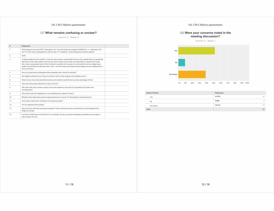
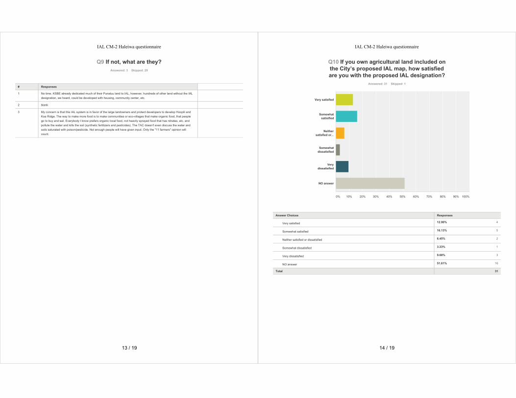


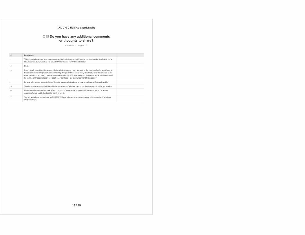
Pacific Guardian Center │ 733 Bishop Street, Makai Tower Suite 2590 │ Honolulu, Hawai‘i 96813
Meeting Date: Monday, November 20, 2017
Meeting Time: 6:00-8:00 PM Project Name: O‘ahu IAL Mapping Project
Location: Aiea Intermediate School Cafeteria Recorded by: Corlyn Orr Reviewed by DPP February 23, 2018
Attendees: see attendance record
Subject: Community Meeting 3
The third and final community meeting for the City’s Important Agricultural Lands (IAL) Mapping Project was held at ‘Aiea Intermediate School on Monday, November 20, 2017. The purpose of the meeting was to provide an update on the outreach efforts since the last meeting, present DPP’s recommendations for county-designated IAL to be transmitted to the City Council, and respond to questions.
WELCOME, INTRODUCTIONS, AND PROJECT BRIEFING
Scott Ezer, meeting facilitator, called the meeting to order at 6:30 PM. Following welcoming remarks, Scott introduced Kathy Sokugawa (Acting Director of the City’s Department of Planning and Permitting (DPP)) and DPP staff, as well as other members of the project team involved in supporting DPP’s effort.
Scott clarified that DPP’s recommendations do not include the Ho‘opili or Koa Ridge project areas because both do not meet the requirements established by State law to be considered for IAL. Individuals who disagree with DPP’s recommendations for Ho‘opili and Koa Ridge should discuss the issue with the City Council, not DPP. Scott then presented an informational briefing that included the history and intent of the IAL legislation; the goals for IAL (to support the economic viability of farming); DPP’s outreach efforts and the comments received during the public comment period; and the criteria for DPP’s recommendations for county-designated IAL.
DPP’s current recommendation for county-designated IAL being presented at the meeting consists of almost 50,000 acres, which is less than the 52,575 acres that were recommended in the previous draft (December 2016) map. DPP is in the process of finalizing the recommended map and accompanying report that will be transmitted to the City Council for review. The City Council will hold hearings to review/revise DPP’s recommendations, then forward their own recommendations to the State Land Use Commission (LUC). The LUC is the final decision-maker with approval authority for lands to be designated as IAL. It is unknown how long the approval process will take.
QUESTION AND ANSWER SESSION
Meeting participants were asked to submit their questions in writing. Scott read each of the following questions out loud and provided a response. Both the questions and responses have been documented nearly verbatim to maintain both the accuracy and authenticity of the statement. (Questions and comments that were submitted but not reviewed during the question-and-answer session due to time limitations are included in ATTACHMENT 1).
1. How will IAL help IAL farmers?
RESPONSE: That’s the first long-term objective of IAL. The most important way that IAL will help farmers is their ability to take advantage of incentives. Incentives are a very important part of the overall program. The State set up a number of incentives. Again, the most important one that I mentioned was the tax
MEETING SUMMARY
O‘ahu IAL Mapping Project Community Meeting 3, Aiea Intermediate School | November 20, 2017 Page 2 of 12
incentive. Unfortunately, that’s going to go away unless people get together and lobby to make sure that continues to be an important part of the IAL process.
2. You guys have to make sure that tax incentive goes further, rather than us do it. What are you doing for the tax credit?
RESPONSE: I don’t have any power to make the tax credit go on. That authority rests with the Hawai‘i State Legislature. In order for the Legislature to make a determination if they want that to move forward, that has to come from the Department of Agriculture, and I have been assured by the Department of Agriculture that they intend to re-submit that bill, and there has to be some traction with your legislators to make that incentive move forward. Senator Riviere is here in the audience tonight, and he’s been at every meeting we’ve had. He understands these issues very well.
3. What is the effect of Important AG Land on taxes?
RESPONSE: You should not see a difference in your taxes. Currently, the county gives you a tax break already if you self-dedicate your land for agricultural purposes. I think there’s a 10-year dedication requirement, and there’s a tremendous break you get on taxes. I don’t know that you can get any more of a break than you already get.
Scott asked for a show of hands to see how many people were aware that there’s a tax break if you dedicate your land for agricultural purposes. He also asked how many actually take advantage of that, and how many are hearing that for the first time. (Very few knew about the tax break.)
4. If you have more than one dwelling, will we be taxed for each dwelling?
RESPONSE: Yes.
5. Can you build a farmstand, food take-out, and labor housing on IAL? What is allowable to build on this land? I’m looking at having value-added products made and sold on the land.
RESPONSE: If you have AG zoning today, you can have as an accessory use, you can have a roadside stand on your property. That isn’t going to change. As I said earlier, the zoning you have on your property today will not change. All the uses that you’re allowed by AG zoning will not change. Can you have labor housing? You’re allowed up to 2 farm dwellings on any land that’s zoned for agricultural use, provided that you have a minimum number twice the lot size for that zoning district. For AG-2, you need 4 acres. For AG-1, you need 10 acres. For any more than 2 farm dwellings, you need to get a different kind of permit from DPP. The opportunity to have labor housing only kicks in under IAL if you self-designate. That’s an incentive that was provided for landowners who self-designate IAL, rather than go through this process.
6. Can part of land be (IAL) separate from residential side (all one TMK, all under one owner)?
RESPONSE: If you’re land is zoned for both AG and residential, yes, you can have separate. If you’re asking can you have a residence on your AG land, the answer to that question is yes. And again, as I explained, you’re allowed up to 2 provided you have enough land area. Each house, each farm dwelling on AG land, is limited to a 5,000 square foot footprint for the house and any dwelling accessory uses, like a garage. But you can have a dwelling. If it is on AG-zoned land, it has to be a farm dwelling.
7. What is the effect of the Important AG Land on acquiring a conditional use permit for meeting use?
RESPONSE (Kathy Sokugawa): How many people know the ALISH system of rating AG lands: the Prime, Unique, Other categories? IAL is very much like that. All it does is give you some kind of a quality description of the land. There is no regulatory attachment to it, so whatever your zoning allows you today is what you can do. That doesn’t mean forever it will be like that, but for now there are no plans to add

O‘ahu IAL Mapping Project Community Meeting 3, Aiea Intermediate School | November 20, 2017 Page 3 of 12
any additional regulations to your designation. If they are, then those would be adopted either by City Council or the State Legislature. The answer to your question, can you put a meeting use? You can apply for any conditional use permit as long as you follow the LUO Zoning Code, and State Agricultural District regulations, Chapter 205, if it’s in the State Agricultural District.
8. We have submitted our letter to the City with reasons why our land does not meet the requirements for IAL. We haven’t heard back from DPP. Why?
RESPONSE (Kathy Sokugawa): Thank you. I’m sorry we were not able to respond to every request, or every letter, so far. As Scott mentioned, we had almost 100 requests to either add or to exclude from IAL. We haven’t written personalized responses, but we do have a table which is available on the website. There’s a matrix: every letter that we got that had a request to either be included or excluded from IAL is included on the matrix and what our final recommendation is. We’re not able to do it tonight, I’m sorry. We would have liked to, but until the very last minute, even up to yesterday, we were making changes. It’s on the website, and we’ll have it as hard copy as part of our final report.
9. Why do you include P-2 zoned land on the IAL map? Isn’t P-2 more restrictive than AG?
RESPONSE: If it is zoned P-2, it probably shouldn’t be there, and it’s a mapping error. However, P-2 could be in the State AG District. Again, many of you, if you received a notice and you’re still in disagreement, I’ll put a contact number and name for you to call after this meeting. The next opportunity you will have to take yourselves out of the IAL map will be when this goes to City Council. People should call their councilmember at this point and ask to be excluded from the map. (P-2 is a county preservation district for lands that are in open space, but are in the State Urban District not the State Conservation District. State Conservation lands are zoned P-1. Those are the watersheds and important resources and natural habitat areas.)
10. How many Commissioners on the LUC are not either builders, developers, or former members of DPP?
RESPONSE: I know there are three members on the Land Use Commission that are cultural experts and practitioners, and I do not know of any members of the LUC that are former DPP employees. The Commissioners are appointed by the Governor, and there are members from each island, and there are some members that are on as at-large members. The City has nothing to do with who gets appointed to the Land Use Commission.
11. What should I do if I do not want my land designated as IAL?
RESPONSE: I will go over that before we close the meeting so you are very clear what your options are moving forward if you do not want to be part of the IAL process.
12. Will the tax rate increase on these lands?
RESPONSE: I think I already answered that. Your tax should not change.
13. Please add oxygen and watershed use as a farming product since you allow solar as a farm product. I’d rather see trees and reforestation on unused property rather than industrial solar farm. While I’m at it, I want to express my deep concern that additional layers of bureaucracy have never made life easier but only more complicated to understand and follow all the rules.
RESPONSE: So far, I think forest products are an allowable use on agricultural land as well as PV farms. Those are identified both at the State level in the State land use district and at the county level. There is the opportunity to view reforestation as a use in the AG districts.
O‘ahu IAL Mapping Project Community Meeting 3, Aiea Intermediate School | November 20, 2017 Page 4 of 12
14. I attended both previous briefings and at both, the audiences unanimously endorsed Ho‘opili be designated IAL.
RESPONSE: I think we covered that.
15. What crop can we grow when land costs $200,000 an acre, meaning how can you expect farmland to stay farmland when the land itself is so expensive?
RESPONSE: I think all of us here tonight appreciate how hard it is to be a farmer. It’s a very difficult lifestyle and it is very challenging from a number of different perspectives. As the person who wrote this question suggests, agricultural land is very expensive. What we are doing with this process is we are trying to address one of the underlying issues, with respect to trying to encourage people to continue to use agricultural land for agricultural purposes. There are many other problems with AG and AG use: water availability, infrastructure availability. This process is dealing with land that will be for AG. We can’t solve all of the problems associated with land and with agriculture just with IAL.
16. Will IAL change the current zoning of the property?
RESPONSE: I think I answered that. Zoning and all the other regulatory aspects of the property will stay the same.
17. If land is designated IAL, will there be any restrictions on subdividing or farm dwellings?
RESPONSE: There will be no restrictions on subdivision or farm dwellings as long as you meet all the requirements for an agricultural subdivision. So you have to have the right number of acres, you have to follow the agricultural subdivision requirements, you have to provide an AG plan that’s acceptable to the State Department of Agriculture. You can have a farm dwelling on any land that’s zoned AG, and you can have up to 2 houses on any agricultural land that has a minimum lot twice the size of the land. More than 3, between 3 and 6, you need another permit from DPP, and over 6, you have to either do subdivision or a cluster.
18. What incentives are the City proposing for IAL?
RESPONSE (Kathy Sokugawa): Right now, we are taking suggestions on that issue. What are some of the incentives? Especially those of you who already have AG dedication incentives. We’re looking at some incentives. We haven’t made up our final list of recommendations yet. Some for AG developers—we know that the water meter connection that Board of Water Supply charges is steep for agricultural lands, so we’ve asked Board of Water Supply to take a look at reducing that cost. Another one that came from our Technical Advisory Committee would be, again, for those of you who are already in the AG dedication process, you’re told every 5 or 10 years you gotta re-up, and that’s something you can’t really do very easily and to remember that, so they’re saying if you’re in IAL, you’d automatically be re-committed so you don’t have to file that information. You still would have to do your annual return, but that’s a small little thing that people might really enjoy. A lot of you do know about that system, but a lot of you also didn’t know about it. I would encourage you to find out about how you can get it because an AG dedication, that means if you promise to continue AG use of your property for X number of years, as long as 10 years, you get a dramatic reduction in your property tax, really dramatic. Look into that. Tonight, if you have some other ideas about county incentives—not state—but county incentives, please put it down on a card and we’ll take a look at that.
19. Somebody asked if I, meaning me, if I had AG land, would I volunteer for IAL and why?
RESPONSE: That’s kind of a loaded question, see as I don’t own AG land. When I was in graduate school at UH, I did my masters’ thesis on the phasing out, at that time, this was back in 1978 and sugar was on its way out. People knew in 1978, a lot of plantations had already closed. I have a familiarity with AG,

O‘ahu IAL Mapping Project Community Meeting 3, Aiea Intermediate School | November 20, 2017 Page 5 of 12
and I think that protecting AG in this state is a very important thing to do. If I had AG land, and I wanted to make sure that AG land was going to be available not just for me, but for those that come after me—you know, people talk about considering what happens over 7 generations, it’s a very important part of the Hawaiian culture—and part of what we are trying to do with this process is make sure that not just my children and your children, but your grandchildren and their grandchildren will still have agricultural land on this island in order to help feed themselves. Everybody knows the facts. We import 90 percent of our food, we only have a 5-day supply of food in the markets. If there’s a shipping strike or catastrophe, we could be looking at a situation not unlike what has happened in Puerto Rico or the Caribbean. This project is a small piece. It’s trying to ensure that the good AG land that we have available today is going to be available for tomorrow, and the tomorrow after that, and the tomorrow after that.
20. Is the Planning Commission involved in the IAL review process?
RESPONSE: They are not.
21. What incentives are the City offering for IAL lands? Would they consider expedited subdivision approvals so that smaller farms could be created to get more farms? What about not requiring an AG feasibility study since you have concluded these lands are IAL?
RESPONSE: There are even today a number of subdivisions that make their way to DPP that are not true agricultural subdivisions. The AG feasibility study is one way that the City can use to try and weed out the real farmers from the not-real farmers.
22. Why can’t you promise that at some future date more rules and restrictions that can make life more difficult for the small individual farmer will not be forced upon owners of IAL? It is my experience that more government oversight makes everything more complicated and restrictive. I’ve tried reading applications and forms as a farmer that are so obtuse that I don’t even understand it, and I’ve got a college degree. I’m presently a good steward of the land. Why should I have more government regulation?
RESPONSE: I tried to explain that IAL does not change the opportunity you have to use the land under your current set of land use regulations.
23. You said tonight that the City Council can change the mapping proposed to them under this process. Isn’t it true that the Council can change the urban core boundary so that Ho‘opili can be designated and protected as IAL?
RESPONSE: In theory that is possible. Given all of the land use decisions that have occurred, that is extremely unlikely that will happen.
24. Why did the City and County falsify Federal documents claiming that Hawai‘i’s most valuable and productive AG land was not suitable for farming? All in the name of the fraudulent rail project. If John Carroll is elected governor, he will file a lawsuit against rail.
Why did the Supreme Court deliberately violate Hawai‘i Constitution public trust doctrine to approve the destruction of our most valuable, productive AG land in Ho‘opili?
RESPONSE: Again, the conversation about Ho‘opili has been going on for 30 years. Its been part of the development plan for ‘Ewa for that long.
25. Kamehameha Schools are not landowners. The Liliuokalani Trust are also not landowners. The royal families exist and are the true landowners. Legal issues remain. What happens now?
RESPONSE: That has to be fought out in court.
O‘ahu IAL Mapping Project Community Meeting 3, Aiea Intermediate School | November 20, 2017 Page 6 of 12
26. How will the City handle requests for majority incentive before the City recommendation adopted by the State?
RESPONSE: Not sure I understand that question.
27. I am one of the konohiki for Victoria Kamamalu whose heir was Mataio Keuanaoa, our ancestor. I am also one of the heirs. Where do your claims begin when we are the paramount/superior title owners? How are you one of the royal families?
RESPONSE: I certainly don’t pretend to be that. I leave that question to the court system.
28. Some people received the notice for the first time. Why? The people did not know about these meetings.
RESPONSE (Kathy Sokugawa): All I can say is we tried our best. Some of you may have gotten it because of changes to the map, as we developed a second version of it. I have to tell you, we had a lot of challenges in getting correct addresses. We still get a lot of them that were sent back because we didn’t have the correct addresses. If you also feel that you should’ve been on the mailing list but weren’t, please fill out a card and put down that you want to be on the mailing list. Or, if you got a letter sent to the wrong place, please correct us on that issue. We primarily based it on real property tax information, but I can’t say that’s 100 percent accurate. So again, if you have a better mailing address to share with us, please do so.
29. What constitutes agricultural activities? There’s no clear definition in the bill.
RESPONSE: The City’s zoning, the Land Use Ordinance, has a list of all the things that are allowed in agricultural districts within the City and County of Honolulu. Chapter 205, the Hawai‘i Revised Statutes, also has a very detailed listing of what constitutes agricultural use and agricultural activities.
30. If we asked to be excluded and were denied, what additional recourse do we have?
RESPONSE: I still think that you should have a conversation with DPP, and I will put all that contact info up. You will also have the opportunity to talk to your council member when these maps get to the City Council.
31. Is there a database of all the affected land owners, and do we have access to it?
RESPONSE: The website that I referred to—MapOahuAgLand.com—shows all of the land being included for recommendation as IAL. You can see the parcels underneath the layer that shows the AG land. You should be able to navigate through the map viewer and look at any parcel on O‘ahu and see whether it is or is not indicated for IAL.
32. How can parcels all around my parcel not be classified IAL but mine is?
RESPONSE: That’s a real good question. Without understanding the exact context of your individual issue, I can’t answer that question. I encourage you to follow up by contacting DPP.
33. How do we appeal this classification?
RESPONSE: Again, you can continue to communicate with DPP, and then follow up with your councilmember.
34. How do I remove my land from IAL?
RESPONSE: Same question and answer.

O‘ahu IAL Mapping Project Community Meeting 3, Aiea Intermediate School | November 20, 2017 Page 7 of 12
35. Why is IAL designation necessary when there is already an easement for the stream that runs through the border of my country-zoned property? I already cannot block or build there.
RESPONSE: IAL is just another way that the City and State have decided to use to identify better AG land.
36. Which chapter or part of Chapter 205, Hawai‘i Revised Statutes is Country zoning a part of? Urban, rural, or AG?
RESPONSE: I believe Country can be either State Urban or State AG.
37. For those families who didn’t want to IAL but are forced to be, why can’t you respond individually as to why their request is rejected? Are you going to be sending individual letters?
RESPONSE (Kathy Sokugawa): We haven’t decided but right now, we only have the matrix. Check the website and if you’re not satisfied with the reason on the website in the matrix, you can contact the Department.
38. How many employee farm dwelling units are allowed on one TMK? Where can I get additional information on this?
RESPONSE: If you self-designate, you can use up to 15 percent of the land that you designate for IAL as employee housing, and that is in Chapter 205. if you want to come up and see me after, I’ll give you a specific citation where that is in the law.
39. How long should it take for farmers to know when they have IAL land?
RESPONSE: I think I explained that after this, we go to City Council. We have no idea how long that’s going to take. Then it goes to Land Use Commission, and we don’t know how long that’s going to take either. It could be several months, or it could be longer than that.
40. Please give examples of incentives besides the tax incentive (2 more incentives). What’s in it for us?
RESPONSE: The loan guarantee that’s available through the State Department of Agriculture. And if you self-designate, you get the employee housing opportunity. Those are the 2 biggest ones that we have today.
41. Is there a way to fast-track self-designated IAL before tax incentives expire in December?
RESPONSE: I would say no. If you’re not IAL now, in order to get that, even if you were to self-designate, there’s a process. You have to go through the Land Use Commission, and it will take several months to make that happen.
42. What is the land size acreage requirement to be included in IAL?
RESPONSE: There is no minimum. I think the lowest is half-acre. The law doesn’t say you have to be a certain size.
43. How come we’re not notified about the IAL of Malaekahana as an owner of 3,100 acres, as opposed to Hawai‘i Reserve Inc. who bought only 600 acres from Campbell Estate?
RESPONSE: I don’t know the answer to that question. I think you should talk to DPP after the meeting or tonight. I’ll give you contact information after the meeting.
44. Should the tax credit have been lobbied by the IAL committee so that this project is received by the public in a more positive light?
O‘ahu IAL Mapping Project Community Meeting 3, Aiea Intermediate School | November 20, 2017 Page 8 of 12
RESPONSE: I think the answer to that is probably yes, that everybody assumed that the legislation was going to go through without any problems. That didn’t happen, and its unfortunate.
(Kathy Sokugawa): I just want to add the bill is not dead. It got stuck in conference committee, so next session they can bring it out of conference committee. You don't need another bill, but you might want to massage existing language. Dr. Lai is the City’s AG Liaison. If you’ve already worked with him or feel more comfortable talking to him about this issue, you can also contact Dr. Lai in the Mayor’s Office.
(Earl Yamamoto, Planner with the Department of Agriculture): The bill number is House Bill (HB) 1584. The administration bill that we submitted as part of our bill package from the Department of Agriculture includes a 10-year extension. It’s maybe a one-page bill—simple—as was the case last year when we first requested an extension to our ability to continue certifying qualified agricultural costs from taxpayers, the farmers that are on designated important agricultural lands. This is versus the one that went all the way through to conference committee this past April that had a number of features that everyone had a problem with one way or another. Many things got added on to the base idea of just extending our department’s ability or responsibility to certify taxpayers’ submitted qualified agricultural costs. Hopefully we can get your support, through your legislator, we can get this administration bill moving forward in the 2018 legislative session. Otherwise as Scott mentioned, without that extension of our ability to qualify costs, that would put an end to the tax credit. The bill number again is HB 1584. Our new bill won’t have a number, but I’ll do my best to let everybody know.
A kupuna (elder) from the audience asked to be recognized: First of all, I’d like to thank all of you. All of you who have come to this meeting. For the first time, in all these years I’ve been involved in politics, I have seen the people of Hawai‘i come together. The one time in my life, we know we are all concerned about the development in all of Hawai‘i and how and who it affects all of us, the people of Hawai‘i. All we can hear is development, development, development from corporations outside of Hawai‘i. Who’s taking care of us? Who’s taking care of our land, our home, our zoning changes—and the taxes going up? Everything that development does is against us. We support all these outside developers that are pressing on our island. We are supporting all of the development, we, our money to pay for them and their investments. I am so proud of us for having the courage to come. One thing I know, we’re all in this together. And if we don’t come together, we lose. We are the Hawaiians, all of us. It’s not about kanaka maoli, its not about races, its about us as a people. We have to stand up together and say enough. Please, put better people in office and take over the council and the senate. Make sure, because if we don’t vote, nobody’s going to take care of us. The politicians make decisions without you knowing. So you know you have to take care yourself and your neighbor. Find the people that’s going to work together because other than that, we’re out of here. Bring your kids, bring your grandkids. You have to teach them, you have to them its their responsibility. Mahalo.
ADJOURNMENT
Scott thanked everyone for attending and being patient to listen to all the questions. He also shared contact information for DPP (call Raymond Young at 808-768-8049), and reminded meeting attendees that the information from the meeting is posted on the project website (MapOahuAgLand.com). The meeting was adjourned at roughly 8:00 PM.
O‘ahu IAL Mapping Project Community Meeting 3, Aiea Intermediate School | November 20, 2017 Page 9 of 12
Attendance Record 1. Ernest Adaniya, Wai‘anae 2. Tomi Adaniya, Wai‘anae 3. Mark Afuso, Mililani 4. Ralph Aona, Wai‘anae 5. L. Gary Bautista, ‘Ewa Beach 6. Pat Beekman, ‘Aiea 7. J. Bennett, Waialua 8. John Bond, Kapolei 9. Pamela Boyar, Kailua 10. Jim Brewer 11. Leo Bright, Kapolei 12. Puanani Burgess, Wai‘anae 13. Rex Cabahug, Wai‘anae 14. Eugene C. Cabana, Waipahu 15. Jeff Cadanova, Wai‘anae 16. Steve Camello, Kapolei 17. Deborah Castro, Wai‘anae 18. Monte Castro, ‘Aiea 19. Miriam Chang, Hale‘iwa 20. Albert S. Chiappetta, Wai‘anae 21. Alonza Cobbin, Wai‘anae 22. Tameria Cobbin, Wai‘anae 23. Raymond Cook, Wai‘anae 24. Carla Cottrell, Wai‘anae 25. Donna M. Costa, Wai‘anae 26. Cathy Cozzens, Wai‘anae 27. Deann Dano, Wai‘anae 28. Pedro Dano, Wai‘anae 29. Mike Dau, Waipahu 30. Laverne DeCoito, Wai‘anae 31. Andy Dewees, Mililani 32. John Domen Jr., Wai‘anae 33. John Dubiel, Hale‘iwa 34. Mary Dubiel, Hale‘iwa 35. Dr. Kioni Dudley, Kapolei 36. Bruse Eckmann, Honolulu 37. Ruby Edwards, State Office of Planning 38. Gilbert Egami, Wai‘anae 39. Raymar H. Egami, Wai‘anae 40. Rayleen Egami, Wai‘anae 41. Ralph Ehni, Hale‘iwa 42. Renee Ehni, Hale‘iwa 43. David Figueira, Kapolei 44. Anne Figueira, Kapolei 45. Sophie Flores, Wai‘anae 46. Jesse Foster, Wai‘anae 47. Margaret Isaacs, Waianae 48. Mr. Byron Fujieki, Honolulu 49. Mrs. Byron Fujieki, Honolulu 50. Michelle Freitas, Wai‘anae 51. Al Frenzel, Makaha 52. Raymond Galderia, Waipahu 53. Tony Gill, Honolulu 54. Andrew Gomes, Honolulu 55. Michelle Gorham, Kailua 56. Colleen Griffith, Wai‘anae 57. Dustin Griffith, Wai‘anae 58. HC&S Farm, Wai‘anae 59. Bruce Hanohano, ‘Aiea 60. Piilani Hanohano, ‘Aiea 61. Craig Hara, Mililani 62. Michelle Hawes-Tomas, ‘Ewa Beach 63. Mitsuko Hayakawa, Pearl City 64. Hattal Henry, Wai‘anae 65. Hong Fang Gan, Wai‘anae 66. Prasong Hsu, Kailua 67. Sunny Hsu, Kailua 68. Leslie Imaoka, Wai‘anae 69. Renee Ing 70. John Ioane, Kapolei 71. James Jones, Wai‘anae 72. Steve Joseph, Wai‘anae 73. Frances Kama-Silva, Wai‘anae 74. John Keawe, Kapolei 75. Amelia Kelly, Waipahu 76. Jonah Keohokapu 77. Bobbi-Lynn Kupihea-Char, Mililani 78. Poka Laenui, Wai‘anae 79. G. Lee, ‘Ewa Beach 80. Paula Lee, Honolulu 81. David Lopes, Hui Ku Like Kakou 82. Noe Lopes, Hui Ku Like Kakou 83. Catalina Lorenzo, Wai‘anae 84. Jimmy Lorenzo, Wai‘anae 85. Mary Lorenzo, Wai‘anae 86. Stephen Lorenzo, Wai‘anae 87. William Lyon, Wai‘anae 88. Renato M., Wai‘anae 89. Agnes Malate, Honolulu 90. Henry Mandac, Wai‘anae 91. Jon Mano, ‘Ewa Beach 92. Noe Mano, Wai‘anae
O‘ahu IAL Mapping Project Community Meeting 3, Aiea Intermediate School | November 20, 2017 Page 10 of 12
93. Alvin S. Masuda, Wai‘anae 94. James McCoy, Honolulu 95. Dean Minakami, Honolulu 96. Keevin Minami, ‘Aiea 97. W.G. Minami, ‘Aiea 98. Luciano Minerbi, Honolulu 99. Lisa Munger, Honolulu 100.Kailana Moa-Eli, Wai‘anae 101.Akeo Nakazawa, Kailua 102.Jim Niermann, R.M. Towill 103.Lauro Nilo, Waipahu 104.Pacita Nilo, Waipahu 105.Faye Nishimura, ‘Aiea 106.Francis Nitta, Waimanalo 107.Steven M. Nitta, Wai‘anae 108.Jay Okada, Wai‘anae 109.Owen K. Kaneshiro Farms LLC, Mililani 110.Marjorie L. Perreira, Wai‘anae 111.D. Perry, Mililani 112.Doug Philpotts 113.Diana P. Puulei, Wai‘anae 114.Joann Rapoza, Wai‘anae 115.Julian Rapoza, Wai‘anae 116.Jocelyn Rasquero, ‘Ewa Beach 117.Dennis Sakuoka, Mililani 118.Pauline Sato, Honolulu 119.Sara Schnabel, Kapolei 120.Joseph Shacat, Honolulu 121.Phyllis Shimabukuro-Geiser, State Dept. of AG 122.Michael Shuman, Waipahu 123.Teresita Shuman, Waipahu 124.Sarah Simmons, Honolulu 125.Henry Silva, Wai‘anae 126.J. Soares, Wai‘anae 127.Faustino Somera, ‘Ewa Beach 128.Patricia Sottile, Kapolei 129.Evelyn Souza, Kapolei 130.Allen Stack Jr., Honolulu 131.Elizabeth Stack 132.Mark Suiso, Makaha 133.David Tamala, Kapolei 134.Bernadette Tebia, Wai‘anae 135.Gina U. Teixeira, Wai‘anae 136.A. Timbreza, Wai‘anae 137.Ronald Timbreza, Kapolei 138.Eustaquio Tubania, Wai‘anae 139.Veronica Tubania, Wai‘anae 140.Tony Turner, ‘Ewa Beach 141.John Tussey, Wahiawā 142.E. Uno, Mililani 143.J. Valderama, ‘Ewa Beach 144.Marilyn Valderama, ‘Ewa Beach 145.Sheila Valdez, Waipahu 146.Kaukaohu Wahilani, Wai‘anae 147.Terry Walden, Wai‘anae 148.Carmela Watanabe, Wai‘anae 149.Stanley Watanabe, Wai‘anae 150.Steve Wendel 151.Ron Wise, Kapolei 152.Andrew Yamaguchi, Kailua 153.Earl Yamamoto, State Dept. of AG 154.Dole Yi, Wai‘anae
Dr. Po-Yung Lai, Mayor’s Agricultural Liaison Kathy Sokugawa, DPP Acting Director Curtis Lum, DPP Raymond Young, DPP Scott Ezer, HHF Planners Eugene Takahashi, DPP Rob James, HHF Planners Erin Higa, HHF Planners Bruce Plasch, Plasch Econ Pacific Corlyn Orr, HHF Planners
O‘ahu IAL Mapping Project Community Meeting 3, Aiea Intermediate School | November 20, 2017 Page 11 of 12
ATTACHMENT 1 The following questions and comments were submitted during the meeting, but were not reviewed during the question-and-answer session because of time limitations.
1. What is the purpose of the IAL designation? How does it ensure the protection of agricultural lands? Please use laymen’s terms.
RESPONSE: See response to Question 1 and 35.
2. Is the goal to bring food self-sufficiency to Hawai‘i?
RESPONSE: The goal is to help farmers by making agriculture viable. See responses to Question 1 and Question 19.
3. Is this a joke? The big boys can manipulate the laws to get the best lands for their agenda and benefit.
RESPONSE: The IAL initiative is intended to help both large and small landowners who are interested in using their agricultural land for farming.
4. What is the difference between “dedicated” land and IAL?
RESPONSE: IAL is a specific land use designation for land in the State Agricultural District. To be IAL requires an approval from the State Land Use Commission. An AG dedication refers to a process where the county provides a tax break in exchange for a landowner’s agreement to maintain agricultural use of their property for a set number of years. See responses to Question 3 and Question 18.
5. The incentive offered only benefits the largest landowners. The farming classes are already available without IAL designation. I could never benefit from the million dollar incentive as a small farmer. Why haven’t you made more real benefits for the little guy?
RESPONSE: See response to Question 18.
6. Where is the funding source for the various incentives listed for IAL?
RESPONSE: The incentives listed in the presentation are state-level incentives funded by the State.
7. What are benefits and cons of being designated IAL? Why does property value go down after being designated IAL? Are there any restrictions on property after being designated IAL?
RESPONSE: The incentives provide economic benefit to IAL landowners. If a landowner is seeking to urbanize their land (i.e., change the State land use district classification from Agricultural to Urban), IAL-designated land will require six votes at the Land Use Commission to approve the change. Property values should not be affected by an IAL designation, as IAL does not change allowable uses. See responses to Questions 7, 16, 17 and 22.
8. U.S. President Cleveland gave Hawai‘i back to Queen Lili‘uokalani in 1894 and in 1897. There was no annexation. Where’s your title? Our alodio titles are superior/paramount titles.
Kamehameha III gave our people alodio land titles, it’s a done deal. The Kingdom of Hawai‘i exists and the state claims to be the successor of the Kingdom of Hawai‘i and that is identified theft….aren’t you legally illegal?
RESPONSE: See response to Question 27.
O‘ahu IAL Mapping Project Community Meeting 3, Aiea Intermediate School | November 20, 2017 Page 12 of 12
9. What happens by 2050 when climate change and other factors prevent food shipments to Hawai‘i? Will we have enough farmland to feed our people? Look at Dr. Kioni Dudley’s research paper on this topic. He is in Makakilo.
RESPONSE: See response to Question 19.
10. Suggestions for incentives: a. encourage AG tourism activities that would support diversified agriculture b. amend the LUO to allow greater uses within IAL that are accessory and support AG operations c. eliminate the need for CUP-Minor permit for accessory uses that support the AG use of the
subject property d. additional property tax breaks without AG dedication process being required
RESPONSE: Thank you for the suggestions. See response to Question 18.
11. Any additional restrictions proposed or envisioned to be imposed on IAL designated lands related to future subdivision? DPP notes that there are no additional restrictions by designating lands IAL, but is that a commitment?
RESPONSE: See responses to Questions 7, 16, 17 and 22.
12. How does the “majority incentive” work? When does that land owner need to voluntarily designate a majority of their lands as IAL in order to not designate the balance of the lands IAL? Based on the City’s schedule to submit the proposed IAL lands to the City Council, how much time is available to seek the “majority incentive” before the Land Use Commissions adopts the IAL recommendations of the City?
RESPONSE: The law provides an incentive for a landowner who designates 85 percent of their land as IAL to concurrently urbanize the remaining 15 percent (urbanize means re-classify land from the State Agricultural District to the State Urban District). The law also states that a landowner who has previously designated at least 50 percent of their agricultural land for IAL is exempt from the county designation process. The process for a landowner to self-designate IAL requires Land Use Commission approval, which can take several months. See response to Questions 39 and 41.
13. General Comment/Question: If there are not significant incentives to having lands designated IAL by the City and there are future risks that the State or City may impose more restrictions on the use of IAL lands (limit subdivision to larger lots or other similar restrictions), why would anyone want their land designated IAL?
RESPONSE: The State Department of Agriculture is seeking to re-instate the qualified agricultural cost tax credit. See response to Question 40 and 44. No restrictions are associated with IAL. See responses to Questions 1, 7, 16, 17 and 22.


ELANDOWNER AND PUBLIC COMMENTS


O‘ahu Important Agricultural Lands Mapping Project SUMMARY OF WRITTEN COMMENTS RECEIVED ON PRELIMINARY RECOMMENDATIONS FOR IAL (2017 VERSION), WITH DPP’S RESPONSES AND ACTIONS FOR THE DRAFT IAL MAP
August 2018| Page 1 of 14
TMK PARCEL STREET ADDRESS LOCATION PARCEL SIZE (acres) COMMENT DPP RECOMMENDATION AND NOTES
DPP ACTION: ADDED TO, REMOVED FROM, OR RETAINED IN IAL MAP
LAND PROPOSED BY DPP FOR IAL INCLUSION
1. 4‐9‐003: 014; 4‐9‐001: 031‐032
Not available Kualoa 0.025 Surrounded by Kualoa Ranch‐owned parcel in IAL Criterion 7‐Critical Mass/Context. Added
2. 5‐5‐004: 007 Not available Laie 3.15 Adjoins large IAL area which seems not correctly mapped Criterion 7‐Critical Mass/Context. Added
3. 5‐6‐006: 002 Not available Malaekahana 1.68 Surrounded by Property Reserve Inc.‐owned parcel in IAL Criterion 7‐Critical Mass/Context. Added
4. 6‐8‐013: 026 68‐252 Olohio St. Waialua 2 Surrounded by lands proposed for IAL designation. Criterion 7‐Critical Mass/Context. Added
5. POID 4694; between 6‐6‐004:003 and 6‐6‐004: 005
Not available Haleiwa NA Surrounded by lands proposed for IAL designation. Criterion 7‐Critical Mass/Context. Added
6. 8‐7‐010: 006 87‐1239 Hakimo Road Waianae 21.138 Surrounded by lands proposed for IAL designation. Criterion 7‐Critical Mass/Context. Added
LAND PROPOSED BY DPP FOR IAL EXCLUSION (Previously proposed for inclusion in Preliminary IAL Map) 1. 4‐1‐023: 024 to 028, 4‐
1‐023: 030 to 035, and portion 4‐1‐024: 035
At the end of Mekia Street Waimanalo NA Classified as in Urban District and thus, not qualified for IAL. Removal. Removed
2. 6‐6‐019: 044 66‐222 Waialua Beach Road Waialua 2.411 Does not meet IAL criteria due to context and not part of
critical mass.
Removal. Removed
3. 9‐2‐044: 007 Roman Catholic Church 92‐455 Makakilo Drive
Kapolei 3.616 Does not meet IAL criteria due to context and not part of
critical mass.
Removal. Removed
4. 9‐2‐044: 008 DR Horton‐Schuler Homes 92‐2140 Kulihi Street
Kapolei 4.574 Does not meet IAL criteria due to context and not part of
critical mass.
Removal. Removed
5. POID 490022 Fort Street Investment Makakilo Drive
Kapolei 14,402 sq.ft Does not meet IAL criteria (2010/SUB‐58 show it for utility
purpose).
Removal. Removed
6. 9‐3‐002: 035 Hawaiian Electric Company Near end of Awaiki Street
Waipahu 1.842 Does not meet IAL criteria (part of a railroad right‐of‐way). Removal. Removed
7. 9‐4‐006: 028 Thomas H. Gentry Trust H‐2 Interstate Hwy. and Ka Uka Boulevard intersection
Waipio 6.287 Does not meet IAL criteria (located within State‐owned right‐
of‐way and also portion of Ka Uka Blvd.).
Removal. Removed
8. 9‐1‐018: 006 Hawaiian Electric Company 91‐1440 Farrington Highway
Kapolei 8.71 Does not meet IAL criteria due to existing HECO substation. Removal. Urban use per Ewa DP. Removed
9. 9‐1‐017: 016 Kahi Mohala 91‐2301 Fort Weaver Road
Kapolei 4.483 Does not meet IAL criteria due to existing special needs housing.
Removal. Urban use per Ewa DP. Removed
10. 9‐1‐017: 121 Saint Francis Medical Care 91‐2127 Fort Weaver Road
Kapolei 4.388 Urban use per Ewa DP. Removal. Removed
11. 9‐1‐017: 062 91‐2230 Fort Weaver Road Kapolei 4.076 Urban use per Ewa DP. Removal. Removed
12. 9‐1‐017: 061 Jesus Christ of Latter Day Saints 91‐2206 Old Fort Weaver Road
Kapolei 12 (approx) Urban use per Ewa DP. Removal. Removed
13. 9‐2‐002: 008 Portion 9‐1‐001: 002
D R Horton – Schuler Homes LLC Mauka of H‐1 Hwy, north of Makakilo Quarry 91‐750 Fort Weaver Road
Kapolei 99.84157.071
Urban use per Ewa DP. Removal. Removed
14. 9‐6‐004: 003 Waiawa Valley, between Wapio and Pearl City at the H‐1/H‐2 Interchange
Waiawa 2.45 Urban use per Central DP. Removal. Removed

O‘ahu Important Agricultural Lands Mapping Project SUMMARY OF WRITTEN COMMENTS RECEIVED ON PRELIMINARY RECOMMENDATIONS FOR IAL (2017 VERSION), WITH DPP’S RESPONSES AND ACTIONS FOR THE DRAFT IAL MAP
August 2018| Page 2 of 14
TMK PARCEL STREET ADDRESS LOCATION PARCEL SIZE (acres) COMMENT DPP RECOMMENDATION AND NOTES
DPP ACTION: ADDED TO, REMOVED FROM, OR RETAINED IN IAL MAP
15. 6‐2‐010: 008 62‐125 Emerson Road Unit A Waialua 1.137 Urban use per North Shore SCP. Removal. Removed
16. 6‐2‐006: 006 6‐2‐007: 011 POID 495885 6‐5‐001: 044 Portion
Dole Food Company, Inc. Various parcels located between Haleiwa Town and Joseph Leong Highway
Waialua 2.07 5.473 2.076 120.541
Urban use per North Shore SCP. Removal. Removed
17. 6‐2‐007: 007 66‐636 Kamehameha Highway Waialua 7.739 Urban use per North Shore SCP. Removal. Removed
18. 6‐6‐017: 036 66‐452 Paalaa Road Waialua 2.234 Urban use per North Shore SCP. Removal. Removed
19. 5‐7‐001: 035 Turtle Bay Wastewater Treatment LLC 57‐82 Kamehameha Highway y
Kahuku 20.505 Urban use per Koolau Loa SCP. Removal. Removed
20. 5‐6‐006: 057 Portion Oceanview Development LLC South of Kahuku town and Kahuku High School
Kahuku 58.439 Urban use per Koolau Loa SCP. Removal. Removed
21. 5‐3‐016: 002 Church of Jesus Christ of Latter Day Saints 53‐26 Makao Road
Hauula 10.599 Urban use per Koolau Loa SCP. Removal. Removed
22. 5‐5‐006: 001 Portion 5‐5‐005: 020 Portion 5‐5‐005: 022 Portion 5‐5‐005: 024 Portion 5‐5‐006: 010
Property Reserve Inc Various parcels within the BYU Hawaii Campus planning area.
Laie 275 10.693 17.433 14.07 10
Urban use per Koolau Loa SCP. Removal. Removed
23. 5‐5‐006: 005
BYU Hawaii Campus Laie 204 Urban use per Koolau Loa SCP. Removal. Removed
24. 5‐5‐006: 032 5‐5‐005: 002
BYU Hawaii Campus Laie 1.4390.64
Urban use per Koolau Loa SCP. Removal. Removed
25. 5‐5‐006: 033 Portion Laie Treatment Works 55‐280 Kamehameha Highway
Laie 8.924 Urban use per Koolau Loa SCP. Removal. Removed
26. 5‐6‐006: 013 Kahuku Medical Center 56‐117 Pualalea Street
Kahuku 7.246 Urban use per Koolau Loa SCP. Removal. Removed
27. 5‐6‐006: 027 Continental Pacific LLC 56‐660 Kamehameha Highway
Kahuku 2.785 Urban use per Koolau Loa SCP. Removal. Removed
28. 5‐6‐006: 054 56‐600 Kamehameha Highway Kahuku 16.942 Urban use per Koolau Loa SCP. Removal. Removed
29. 9‐5‐001: 075 Mililani Town Association Mililani near H‐2 Hwy
Mililani 13.236 Urban use per Central Oahu SCP. Removal. Removed
30. 9‐5‐046: 041 Portion Castle & Cooke Properties Mililani Tech Park gully
Mililani 21.497 Urban use per Central Oahu SCP. Removal. Removed
31. 5‐9‐005: 014 Leinau Holding Company LLC 59‐754 Kamehameha Highway
Haleiwa 0.456 Urban use per North Shore SCP. Removal. Removed
32. 5‐9‐005: 069 Church of Jesus Christ of Latter Day Saints 59‐406 Kamehameha Highway
Haleiwa 11.091 Urban use per North Shore SCP. Removal. Removed
33. 5‐9‐005: 040 59‐680 Pupukea Road Haleiwa 50.275 Urban use per North Shore SCP. Removal. Removed portion
34. 5‐9‐005: 084 Meleana’s Farm LLC 59‐410B Kamehameha Highway
Haleiwa 3.213 Urban use per North Shore SCP. Removal. Removed
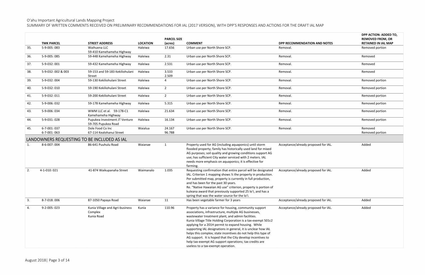
O‘ahu Important Agricultural Lands Mapping Project SUMMARY OF WRITTEN COMMENTS RECEIVED ON PRELIMINARY RECOMMENDATIONS FOR IAL (2017 VERSION), WITH DPP’S RESPONSES AND ACTIONS FOR THE DRAFT IAL MAP
August 2018| Page 3 of 14
TMK PARCEL STREET ADDRESS LOCATION PARCEL SIZE (acres) COMMENT DPP RECOMMENDATION AND NOTES
DPP ACTION: ADDED TO, REMOVED FROM, OR RETAINED IN IAL MAP
35. 5‐9‐005: 083 Waihuena LLC 59‐410 Kamehameha Highway
Haleiwa 17.656 Urban use per North Shore SCP. Removal. Removed portion
36. 5‐9‐005: 085 59‐448 Kamehameha Highway Haleiwa 2.31 Urban use per North Shore SCP. Removal. Removed
37. 5‐9‐032: 001 59‐432 Kamehameha Highway Haleiwa 2.531 Urban use per North Shore SCP. Removal. Removed
38. 5‐9‐032: 002 & 003 59‐153 and 59‐183 Kekiliohulani Street
Haleiwa 3.5332.509
Urban use per North Shore SCP. Removal. Removed
39. 5‐9‐032: 004 59‐130 Kekiliohulani Street Haleiwa 4 Urban use per North Shore SCP. Removal. Removed portion
40. 5‐9‐032: 010 59‐190 Kekiliohulani Street Haleiwa 2 Urban use per North Shore SCP. Removal. Removed portion
41. 5‐9‐032: 011 59‐200 Kekiliohulani Street Haleiwa 2 Urban use per North Shore SCP. Removal. Removed portion
42. 5‐9‐006: 032 59‐178 Kamehameha Highway Haleiwa 5.315 Urban use per North Shore SCP. Removal. Removed portion
43. 5‐9‐006: 034 WWM LLC et al. 59‐178‐C1 Kamehameha Highway
Haleiwa 21.634 Urban use per North Shore SCP. Removal. Removed portion
44. 5‐9‐031: 028 Pupukea Investment JT Venture 59‐705 Pupukea Road
Haleiwa 16.134 Urban use per North Shore SCP. Removal. Removed portion
45. 6‐7‐001: 037 6‐7‐001: 063
Dole Food Co Inc 67‐114 Kealohanui Street
Waialua 24.167 96.788
Urban use per North Shore SCP. Removal. RemovedRemoved portion
LANDOWNERS REQUESTING TO BE INCLUDED AS IAL 1. 8‐6‐007: 004 86‐641 Puuhulu Road Waianae 1 Property used for AG (including aquaponics) until storm
flooded property; family has historically used land for mixed AG purposes; soil quality and growing conditions support AG use; has sufficient City water serviced with 2 meters. IAL needs more emphasis on aquaponics; it is effective for farming.
Acceptance/already proposed for IAL. Added
2. 4‐1‐010: 021 41‐874 Waikupanaha Street Waimanalo 1.035 Requesting confirmation that entire parcel will be designated IAL. Criterion 1 mapping shows ½ the property in production. Per submitted map, property is currently in full production, and has been for the past 30 years. Re. “Native Hawaiian AG use” criterion, property is portion of kuleana award that previously supported 25 lo‘i, and has a spring that was the water source for the lo‘i.
Acceptance/already proposed for IAL. Added
3. 8‐7‐018: 006 87‐1050 Papaya Road Waianae 11 Has been vegetable farmer for 3 years Acceptance/already proposed for IAL. Added
4. 9‐2‐005: 023 Kunia Village and Agri‐business Complex Kunia Road
Kunia 110.96 Property has a variance for housing, community support associations, infrastructure, multiple AG businesses, wastewater treatment plant, and admin facilities. Kunia Village Title Holding Corporation is a tax‐exempt 501c2 applying for a 201H permit to expand housing. While supporting IAL designations in general, it is unclear how IAL helps this complex; state incentives do not help this type of AG support. It is hoped that the City develop incentives to help tax‐exempt AG support operations; tax credits are useless to a tax‐exempt operation.
Acceptance/already proposed for IAL. Added

O‘ahu Important Agricultural Lands Mapping Project SUMMARY OF WRITTEN COMMENTS RECEIVED ON PRELIMINARY RECOMMENDATIONS FOR IAL (2017 VERSION), WITH DPP’S RESPONSES AND ACTIONS FOR THE DRAFT IAL MAP
August 2018| Page 4 of 14
TMK PARCEL STREET ADDRESS LOCATION PARCEL SIZE (acres) COMMENT DPP RECOMMENDATION AND NOTES
DPP ACTION: ADDED TO, REMOVED FROM, OR RETAINED IN IAL MAP
5. 5‐9‐023: 011 59‐620 Maulukua Place Pupukea 1.418 No reason given for wanting to be included No change; lot is within area zoned Country District and lots in this subdivision are proposed by DPP for removal as they are inconsistent with IAL criteria.
Removed
6. 7‐1‐001: 011 Poamoho Camp 71‐45 Kamehameha Hwy
Poamoho 79.202 Appreciates IAL consideration for Poamoho Camp Accept/already proposed for IAL. Retained
7. 6‐7‐004: 001 6‐7‐004: 004 6‐7‐003: 002 6‐7‐003: 006 6‐7‐003: 007
Kaukonahua Ranch, LLC Kamananui, Waialua
North Shore 1,569.8979.01 230.0 106.48 136.0
Concur as agricultural development of the lands may benefit from some of the incentives.
Meets one or more criteria Meets one or more criteria Meets one or more criteria Meets one or more criteria Meets one or more criteria
Retained
LANDOWNERS REQUESTING TO BE EXCLUDED AS IAL 1. 4‐1‐010: 018 41‐950 Kakaina Street Waimanalo 0.735 Property is steeply sloped, is not currently in or ever been
used for AG. Property is too small to sustain profitable farming. Usable acreage has been developed with residential structures.
No change; Meets criteria 2 & 5; also is part of 23‐acre privately owned lots proposed for IAL surrounded by State‐owned parcels.
Retained
2. 4‐2‐014:006 ABP Residuary ABL Hahani LLC (A&B Properties) 1015 Auloa Road
Kailua 75.029 App. 25 acres in the State Urban District. Not currently in AG use; never used for commercial crop production. Soils are not conducive for growing crops; per LSB ratings, 75% of property rated “E”, 25% rated “C”; USDA Soil Survey Database rates property “NOT PRIME.” Water to support AG is not available
Removal; does not meet IAL criteria due to context and not part of critical mass.
Removed
3. 4‐8‐004: 016 4‐8‐004: 017
Ka Mauna o Oliveta Church 48‐146 Waikane Valley Road 48‐148 Waikane Valley Road
Waikane 6.4451.232
TMK Parcel 4‐8‐004: 016 is owned by a hui. Property is occupied by a church, not used for AG purposes.
Removal; does not meet IAL criteria due to context and not part of critical mass; surrounded by lands owned by CCHNL for future Waikane Nature Preserve.
Removed
4. 5‐1‐001: 019 51‐196 A Kamehameha Highway Kaaawa 0.1152 Property is classified for tax purposes as RESIDENTIAL, and does not pass the criteria and conditions of IAL.
Removal; does not meet IAL criteria due to context and not part of critical mass.
Removed
5. 5‐4‐004:003 Asia Pacific Educational Foundation 54‐230 Kamehameha Highway
Hauula 77.6 Property has a CUPm for school use. APEF is a private K‐13, accredited day/boarding school. Ten‐acre portion in the State and City AG districts proposed for IAL designation only meets 2 of the 8 criteria: soil qualities and classification under AG productivity rating systems. Given DPP’s previous characterization of the parcel as a preservation rather than AG parcel, not appropriate for DPP to suggest it should be designated as IAL. Jan 20, 2017
Removal of portion that does not meet IAL criteria due to context and not part of critical mass; portion that is level/formerly in production is proposed for IAL.
Removed Portion
6. 5‐3‐009: 068‐0001 5‐3‐009: 068‐0002
53‐772 Kamehameha Highway Unit 1B
Hauula 5.794 0.344
Land is part of Kaluanui AG area and has high water table that is close to the surface; location across from ocean creates high amount of salt spray that kills vegetation. See attached AG Feasibility Study findings for documentation re. poor soil conditions
No change; parcel meets IAL criteria. Retained
7. 5‐3‐009: 069‐0001 5‐3‐009: 069‐0002 5‐3‐009: 070‐0001 5‐3‐009: 070‐0002
53‐772 Kamehameha Highway Unit 1C
Hauula 5.4 0.344 5.534 0.344
Land is part of Kaluanui AG area and has high water table that is close to the surface; location across from ocean creates high amount of salt spray that kills vegetation. See attached Ag. Feasibility Study findings for documentation re. poor soil conditions.
No change; Ag. feasibility study submitted by ownerdoes not conclude that the parcels are not feasible for ag production.
Retained
8. 5‐3‐015:029 53‐2 Halai Place Hauula 1.00 Property is not productive or fruitful. Trees have not produced fruit in 11 years that he’s lived here; only albizia and palms are thriving.
Removal; entire Country Zoned subdivision being removed due to context and is not part of critical mass.
Removed
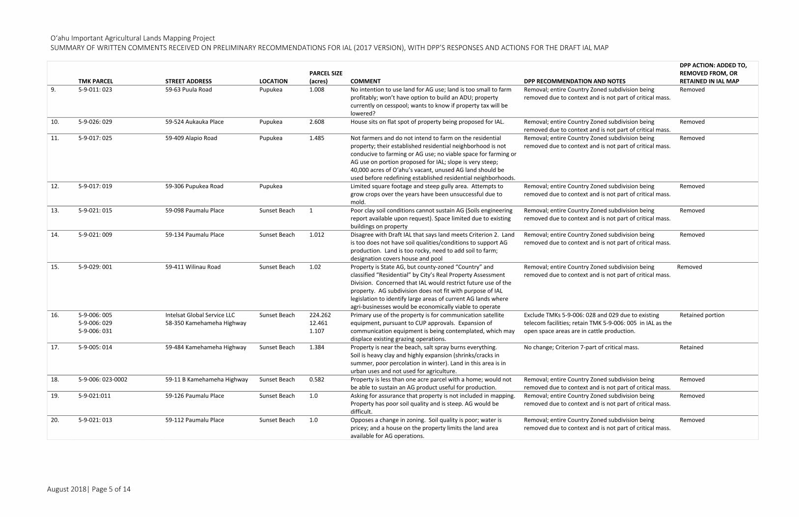
O‘ahu Important Agricultural Lands Mapping Project SUMMARY OF WRITTEN COMMENTS RECEIVED ON PRELIMINARY RECOMMENDATIONS FOR IAL (2017 VERSION), WITH DPP’S RESPONSES AND ACTIONS FOR THE DRAFT IAL MAP
August 2018| Page 5 of 14
TMK PARCEL STREET ADDRESS LOCATION PARCEL SIZE (acres) COMMENT DPP RECOMMENDATION AND NOTES
DPP ACTION: ADDED TO, REMOVED FROM, OR RETAINED IN IAL MAP
9. 5‐9‐011: 023 59‐63 Puula Road Pupukea 1.008 No intention to use land for AG use; land is too small to farm profitably; won’t have option to build an ADU; property currently on cesspool; wants to know if property tax will be lowered?
Removal; entire Country Zoned subdivision being removed due to context and is not part of critical mass.
Removed
10. 5‐9‐026: 029 59‐524 Aukauka Place Pupukea 2.608 House sits on flat spot of property being proposed for IAL. Removal; entire Country Zoned subdivision being removed due to context and is not part of critical mass.
Removed
11. 5‐9‐017: 025 59‐409 Alapio Road Pupukea 1.485 Not farmers and do not intend to farm on the residential property; their established residential neighborhood is not conducive to farming or AG use; no viable space for farming or AG use on portion proposed for IAL; slope is very steep; 40,000 acres of O‘ahu’s vacant, unused AG land should be used before redefining established residential neighborhoods.
Removal; entire Country Zoned subdivision being removed due to context and is not part of critical mass.
Removed
12. 5‐9‐017: 019 59‐306 Pupukea Road Pupukea Limited square footage and steep gully area. Attempts to grow crops over the years have been unsuccessful due to mold.
Removal; entire Country Zoned subdivision being removed due to context and is not part of critical mass.
Removed
13. 5‐9‐021: 015 59‐098 Paumalu Place Sunset Beach 1 Poor clay soil conditions cannot sustain AG (Soils engineering report available upon request). Space limited due to existing buildings on property
Removal; entire Country Zoned subdivision being removed due to context and is not part of critical mass.
Removed
14. 5‐9‐021: 009 59‐134 Paumalu Place Sunset Beach 1.012 Disagree with Draft IAL that says land meets Criterion 2. Land is too does not have soil qualities/conditions to support AG production. Land is too rocky, need to add soil to farm; designation covers house and pool
Removal; entire Country Zoned subdivision being removed due to context and is not part of critical mass.
Removed
15. 5‐9‐029: 001 59‐411 Wilinau Road Sunset Beach 1.02 Property is State AG, but county‐zoned “Country” and classified “Residential” by City’s Real Property Assessment Division. Concerned that IAL would restrict future use of the property. AG subdivision does not fit with purpose of IAL legislation to identify large areas of current AG lands where agri‐businesses would be economically viable to operate
Removal; entire Country Zoned subdivision being removed due to context and is not part of critical mass.
Removed
16. 5‐9‐006: 005 5‐9‐006: 029 5‐9‐006: 031
Intelsat Global Service LLC 58‐350 Kamehameha Highway
Sunset Beach 224.262 12.461 1.107
Primary use of the property is for communication satellite equipment, pursuant to CUP approvals. Expansion of communication equipment is being contemplated, which may displace existing grazing operations.
Exclude TMKs 5‐9‐006: 028 and 029 due to existing telecom facilities; retain TMK 5‐9‐006: 005 in IAL as the open space areas are in cattle production.
Retained portion
17. 5‐9‐005: 014 59‐484 Kamehameha Highway Sunset Beach 1.384 Property is near the beach, salt spray burns everything.Soil is heavy clay and highly expansion (shrinks/cracks in summer, poor percolation in winter). Land in this area is in urban uses and not used for agriculture.
No change; Criterion 7‐part of critical mass. Retained
18. 5‐9‐006: 023‐0002 59‐11 B Kamehameha Highway Sunset Beach 0.582 Property is less than one acre parcel with a home; would not be able to sustain an AG product useful for production.
Removal; entire Country Zoned subdivision being removed due to context and is not part of critical mass.
Removed
19. 5‐9‐021:011 59‐126 Paumalu Place Sunset Beach 1.0 Asking for assurance that property is not included in mapping. Property has poor soil quality and is steep. AG would be difficult.
Removal; entire Country Zoned subdivision being removed due to context and is not part of critical mass.
Removed
20. 5‐9‐021: 013 59‐112 Paumalu Place Sunset Beach 1.0 Opposes a change in zoning. Soil quality is poor; water is pricey; and a house on the property limits the land area available for AG operations.
Removal; entire Country Zoned subdivision being removed due to context and is not part of critical mass.
Removed
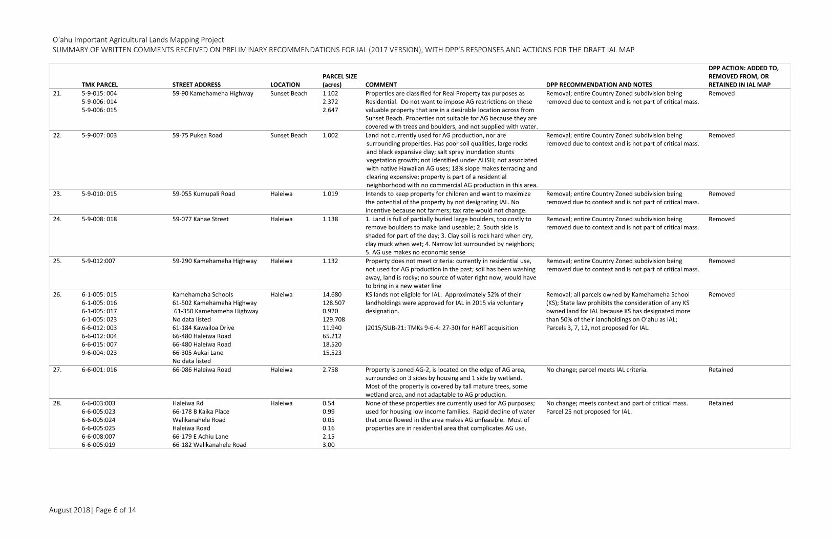
O‘ahu Important Agricultural Lands Mapping Project SUMMARY OF WRITTEN COMMENTS RECEIVED ON PRELIMINARY RECOMMENDATIONS FOR IAL (2017 VERSION), WITH DPP’S RESPONSES AND ACTIONS FOR THE DRAFT IAL MAP
August 2018| Page 6 of 14
TMK PARCEL STREET ADDRESS LOCATION PARCEL SIZE (acres) COMMENT DPP RECOMMENDATION AND NOTES
DPP ACTION: ADDED TO, REMOVED FROM, OR RETAINED IN IAL MAP
21. 5‐9‐015: 004 5‐9‐006: 014 5‐9‐006: 015
59‐90 Kamehameha Highway Sunset Beach 1.1022.372 2.647
Properties are classified for Real Property tax purposes as Residential. Do not want to impose AG restrictions on these valuable property that are in a desirable location across from Sunset Beach. Properties not suitable for AG because they are covered with trees and boulders, and not supplied with water.
Removal; entire Country Zoned subdivision being removed due to context and is not part of critical mass.
Removed
22. 5‐9‐007: 003 59‐75 Pukea Road Sunset Beach 1.002 Land not currently used for AG production, nor are surrounding properties. Has poor soil qualities, large rocks and black expansive clay; salt spray inundation stunts vegetation growth; not identified under ALISH; not associated with native Hawaiian AG uses; 18% slope makes terracing and clearing expensive; property is part of a residential neighborhood with no commercial AG production in this area.
Removal; entire Country Zoned subdivision being removed due to context and is not part of critical mass.
Removed
23. 5‐9‐010: 015 59‐055 Kumupali Road Haleiwa 1.019 Intends to keep property for children and want to maximize the potential of the property by not designating IAL. No incentive because not farmers; tax rate would not change.
Removal; entire Country Zoned subdivision being removed due to context and is not part of critical mass.
Removed
24. 5‐9‐008: 018 59‐077 Kahae Street
Haleiwa 1.138 1. Land is full of partially buried large boulders, too costly to remove boulders to make land useable; 2. South side is shaded for part of the day; 3. Clay soil is rock hard when dry, clay muck when wet; 4. Narrow lot surrounded by neighbors; 5. AG use makes no economic sense
Removal; entire Country Zoned subdivision being removed due to context and is not part of critical mass.
Removed
25. 5‐9‐012:007 59‐290 Kamehameha Highway Haleiwa 1.132 Property does not meet criteria: currently in residential use, not used for AG production in the past; soil has been washing away, land is rocky; no source of water right now, would have to bring in a new water line
Removal; entire Country Zoned subdivision being removed due to context and is not part of critical mass.
Removed
26. 6‐1‐005: 015 6‐1‐005: 016 6‐1‐005: 017 6‐1‐005: 023 6‐6‐012: 003 6‐6‐012: 004 6‐6‐015: 007 9‐6‐004: 023
Kamehameha Schools 61‐502 Kamehameha Highway 61‐350 Kamehameha Highway No data listed 61‐184 Kawailoa Drive 66‐480 Haleiwa Road 66‐480 Haleiwa Road 66‐305 Aukai Lane No data listed
Haleiwa 14.680128.507 0.920 129.708 11.940 65.212 18.520 15.523
KS lands not eligible for IAL. Approximately 52% of their landholdings were approved for IAL in 2015 via voluntary designation. (2015/SUB‐21: TMKs 9‐6‐4: 27‐30) for HART acquisition
Removal; all parcels owned by Kamehameha School (KS); State law prohibits the consideration of any KS owned land for IAL because KS has designated more than 50% of their landholdings on O‘ahu as IAL; Parcels 3, 7, 12, not proposed for IAL.
Removed
27. 6‐6‐001: 016 66‐086 Haleiwa Road Haleiwa 2.758 Property is zoned AG‐2, is located on the edge of AG area, surrounded on 3 sides by housing and 1 side by wetland. Most of the property is covered by tall mature trees, some wetland area, and not adaptable to AG production.
No change; parcel meets IAL criteria. Retained
28. 6‐6‐003:003 6‐6‐005:023 6‐6‐005:024 6‐6‐005:025 6‐6‐008:007 6‐6‐005:019
Haleiwa Rd 66‐178 B Kaika Place Walikanahele Road Haleiwa Road 66‐179 E Achiu Lane 66‐182 Walikanahele Road
Haleiwa 0.54 0.99 0.05 0.16 2.15 3.00
None of these properties are currently used for AG purposes; used for housing low income families. Rapid decline of water that once flowed in the area makes AG unfeasible. Most of properties are in residential area that complicates AG use.
No change; meets context and part of critical mass. Parcel 25 not proposed for IAL.
Retained

O‘ahu Important Agricultural Lands Mapping Project SUMMARY OF WRITTEN COMMENTS RECEIVED ON PRELIMINARY RECOMMENDATIONS FOR IAL (2017 VERSION), WITH DPP’S RESPONSES AND ACTIONS FOR THE DRAFT IAL MAP
August 2018| Page 7 of 14
TMK PARCEL STREET ADDRESS LOCATION PARCEL SIZE (acres) COMMENT DPP RECOMMENDATION AND NOTES
DPP ACTION: ADDED TO, REMOVED FROM, OR RETAINED IN IAL MAP
29. 6‐2‐004: 003 6‐2‐004: 029 6‐2‐004: 050 6‐2‐004: 051 6‐2‐004: 052 6‐2‐004: 053 6‐2‐004: 054
62‐204 Emerson Road
Haleiwa 0.2660.332 2.67 0.643 0.332 0.854 0.161
Farming on this property is not practical on a commercial basis. AG activity in close proximity to Haleiwa and Waialua—which is a water sports mecca and continue to experience commercial/residential growth—will lead to conflict like he experienced at Sunset Beach. IAL offers no landowner compensations, no reduced property taxes. Do not want restrictions on use of property.
No change; due to context and part of critical mass. Retained
30. 6‐2‐005:002 Basin Project Kamehameha Highway
Haleiwa 7.525 Property not intended to be used for AG. Property is in State Urban District, Designated by NSSCP for in‐fill development, in the process of preparing a zone change application
Removal; urban use per North Shore SCP. Removed
31. 6‐6‐003:013 6‐2‐002:019
66‐193 Kamehameha Highway 370 Joseph P Leong Highway
Haleiwa 1.11 0.41
Willing to designate parcel 013 as IAL in exchange for rezoning parcel 6‐6‐009: 015 from AG to R‐5. Willing to designate parcel 6‐2‐004: 027 as IAL in exchange for rezoning of parcel 019 from AG to R‐5
No change; due to context and critical mass; Retain Parcel 19 as part of IAL; Parcel 13 not proposed for IAL; proposed zoning in exchange for IAL not supported.
Retained
32. 6‐6‐020: 019 66‐794 Haleiwa Road Haleiwa 2.07 Soil is unproductive, prone to flooding with brackish water from Paukauila Stream. Request determination: What incentives will the State give to make land productive? Will they pay for truckloads of dirt to make soil fertile? If State and County cannot help, request that property be excluded from IAL and be REZONED to residential like neighbors.
No change; due to context and critical mass. Retained
33. 6‐6‐009: 002 6‐6‐010: 003
HTP LLC Kilioe Place Property LLC 66‐149 Naoiwi Lane 66‐71 Achiu Lane
Haleiwa 1.26 3.593
Per Dec‐22‐2016 report to Planning Commission, DPP recommended approving a State Land Use Amendment from AG to Urban, and zone change from AG‐2 to R‐5 to urbanize these parcels. Independent AG Study concluded jte property “is poorly suited for typical commercial field farming.”
Parcel 002 ‐ No change; due to context and critical mass; Parcel 003 – Within the Urban District and IAL does not apply.
Retained
34. 6‐5‐001: 033 0004 65‐660 A Kaukonahua Road Waialua 5.088 Lot is far from being able to be farmed. Development lacks basic infrastructure for farming: no paved road; no permanent water supply, AG water supply needs pump improvements; cannot live on property; lack of security gate
No change. Retained
35. 6‐6‐019: 043 66‐222 Waialua Beach Road Waialua 2.15 Would like ability to possibly change land use designation in the near future; do not want to be locked into IAL.
Removal; due to context and is not part of critical mass. Removed
36. 6‐7‐003: 003 6‐7‐003: 005
Kaala Ranch Kahui Street 67‐80 Farrington Highway
Waialua 109.543244.380
Property currently used for grazing purposes. Not high quality farm land; large portions are too steep and/or inaccessible for diversified AG; land not capable of producing sustained high AG yields and does not meet the definition of IAL.
No change Retained
37. 6‐7‐002: 038 6‐7‐002: 006‐0001
67‐290 Farrington Highway 67‐290 Farrington Highway (Unit A)
Waialua 103.154.187
Property is not currently in AG production as depicted in Draft IAL Map, or previously farmed. Some cattle are rotated on Parcel 38; Parcel 6 is in condo ownership, with easements that reduce the usable area.. Does not have favorable soil qualities or growing conditions. Ewa Stony Silty Clay soil type is only suitable for prime AG land if irrigated: there is no irrigation system and adequate amounts of water are not available for crops or orchards. Property is hilly, sloping and not flat like neighboring properties; surrounded by urban uses, including an AG residential subdivision and church.
No change Retained
38. 6‐8‐013: 023 68‐208 Olohio Street Waialua 2.17 Landowner currently renting out property for a horse pasture. Do not want IAL because property is surrounded on all sides by residences, parcel is small, and not part of large AG area.
No change Retained
O‘ahu Important Agricultural Lands Mapping Project SUMMARY OF WRITTEN COMMENTS RECEIVED ON PRELIMINARY RECOMMENDATIONS FOR IAL (2017 VERSION), WITH DPP’S RESPONSES AND ACTIONS FOR THE DRAFT IAL MAP
August 2018| Page 8 of 14
TMK PARCEL STREET ADDRESS LOCATION PARCEL SIZE (acres) COMMENT DPP RECOMMENDATION AND NOTES
DPP ACTION: ADDED TO, REMOVED FROM, OR RETAINED IN IAL MAP
39. 6‐6‐028: 022 Mohala Farms 66‐1380 Kaukonahua Road
Waialua 6.088 IAL process unfairly benefits large landowners over small farmers. Process jeopardizes large areas of AG land for rezoning/development. Incentives should be provided to any legitimate farmer that provides local food for local consumption, regardless of IAL land or not.
No change Retained
40. 6‐4‐003: 008 9‐5‐046: 010 7‐1‐002: 033 7‐1‐002: 033 6‐4‐004:007
Dole Plantation Castle & Cooke Properties Wikao Street‐Leilehua Golf Road Whitmore Avenue Whitmore Avenue 64‐1550 Kamehameha Highway
Wahiawa Mililani Tech Whitmore Whitmore Wahiawa
14.443 1.003 31.551 22.473 222.614
Dole Plantation is a popular visitor destination; IAL contradicts and adversely impact uses as approved by State and City permits. Parcel is landscaped, open space amenity for Tech Park Conveyed on 12/30/16 to DHHL Conveyed on 12/30/16 to DHHL
Removal (Parcel 008) Removal (Parcel 10) Removal; Parcel 33 (part) dropped into 71002037 and
transferred to DHHL. Removal; Parcel 7 does not meet IAL Criteria; encumbered by restrictive covenant per 2003/SUP‐1.
RemovedRemoved Removed Removed
41. 7‐1‐001: 007 7‐1‐001: 029 7‐1‐001: 032
Greenworld Farms Kamehameha Highway Wilikina Drive 71‐101 Kamehameha Highway
Wahiawa 3.1470.492 3.632
Coffee visitor center and retail coffee shop is profitable component of coffee growing business. Limitations of site due to location surrounded by regional highways and the cost of paying urban water rates. Possible future use to expand agri‐business activity do not align with IAL.
No change; covenant per CUP granting the use requiresagriculture use on the property.
Retained
42. 8‐3‐002: 013 8‐3‐002: 012
Hahn Family Foundation Farrington Highway
Makaha
20.28918.52
Attorneys have not completed evaluation of property, but submitting general objection to IAL designation.
Removal; does not meet IAL criteria. Removed
43. 8‐3‐002: 011 0001 8‐3‐002: 011 0002
83‐500 Farrington Highway Makaha 10.183 10.126
Land is not used for AG production; soil test determined not suitable for AG purposes; not identified under ALISH; not used for Native Hawaiian AG use; no water; not consistent with county/state plans; not critical to mass; not near support infrastructure
Removal; does not meet IAL criteria. Removed
44. 8‐3‐001: 024 8‐3‐001: 025 8‐3‐001: 026 8‐3‐001: 027 8‐3‐001: 034 8‐3‐001: 037 8‐3‐001: 042
McCandless Ranch Farrington Highway
Ohikilolo, Makaha
12.44314.949 6.39 6.25 17.8 3.13 332.221
Properties do not meet or fall within the criteria of IAL. Any re‐designation or re‐classification that affects rights, title or value amounts to a wrongful taking. Requests copies of legal opinions supporting DPP’s statements that IAL designation does not constitute a taking or invoke the eminent domain clause or process. Property is rated LSB “E”, not high‐quality farmland for IAL designation. Current cattle ranching operation sends cattle to CA for processing and consumption. Farm does not contribute to feeding HI residents. Requests information about land restrictions that apply to IAL.
Removal of all parcels; do not meet IAL criteria. Removed
45. 8‐3‐001: 004 St. Francis Healthcare 83‐300 Farrington Highway
Makaha 58.547 Property is home to Our Lady of Keaáu (OLK) Spiritual Retreat Center. Part of land area identified for IAL is located in two FEMA flood zones. While certain areas of the campus are used for AG purposes, the land identified for IAL is across the highway from a homeless encampment and not planned for AG use because of thefts and security concerns.
Removal; does not meet IAL criteria. Removed
46. 8‐3‐001: 040 8‐3‐001: 041
Farrington Highway Makaha 54.5 237.98
Property does not have water, parcel is arid, portions within 100 yards of coastline are susceptible to salt spray that inhibits crop production.
Removal; does not meet IAL criteria. (Parcel 41 not in IAL)
Removed

O‘ahu Important Agricultural Lands Mapping Project SUMMARY OF WRITTEN COMMENTS RECEIVED ON PRELIMINARY RECOMMENDATIONS FOR IAL (2017 VERSION), WITH DPP’S RESPONSES AND ACTIONS FOR THE DRAFT IAL MAP
August 2018| Page 9 of 14
TMK PARCEL STREET ADDRESS LOCATION PARCEL SIZE (acres) COMMENT DPP RECOMMENDATION AND NOTES
DPP ACTION: ADDED TO, REMOVED FROM, OR RETAINED IN IAL MAP
47. 8‐5‐003: 029 8‐5‐003: 031 8‐5‐003: 032 8‐5‐003: 043 8‐5‐019: 035
Mountain View Dairy 85‐580 Waianae Valley Road
18.90758.565 83.816 61.25 2.544
Property not suitable for farm planting: numerous test crops over the years have been unsuccessful; UH‐CTAHR conducted soil analysis that showed extremely acidic soil with high salt levels. Two wells on the property have been identified as the source of salt. Given the lack of remedy for salty soil conditions, poor soil conditions and difficult topography, property does not qualify for IAL.
No change; due to context and critical mass; Parcel 32 not proposed for IAL.
Retained
48. 8‐6‐011: 004 86‐346 Halona Road Lualualei 22.783 Do not want to participate in IAL. Property has been in family for 96 years and is the family’s legacy; currently used for a piggery, flower farm, fruit trees, and aquaponics that support family members.
No change; due to context and critical mass. Retained
49. 8‐6‐012: 004 Orchids of Waianae 86‐347 Halona Road
Lualualei 4.562 Surrounded by residences, neighbors filed nuisance complaints against them for chemical spraying. Location makes AG operation difficult.
No change; due to context and critical mass. Retained
50. 8‐6‐012: 022 86‐408 A Lualualei Homestead Road
Waianae 1.391 Property is zoned Country and AG, Residential classification for property tax purposes. Currently vacant with kiawe trees, etc.; bordered by concrete drainage culvert, road and other residences. Do not want to reduce the property’s value
No change; due to context and critical mass. Retained
51. 8‐7‐009: 007 PVT Land Company Hakimo Road
Maili 179.109 Property not currently in AG production or historically used for AG. MnC and LuB soils are not conducive for cultivation. Moreso, USDA soil classification date not consistent with the specific geotechnical data. Concurs with Draft IAL map that property does not have sufficient water. See letter for detailed analysis of other criteria.
Remove as soils analysis indicates portion of property is unsuitable for agricultural production; sufficient water is not available.
Removed
52. 8‐7‐009: 026 PVT Land Company 87‐2020 Farrington Highway
Maili 12.946 Property not currently in AG production or historically used for AG. MnC soils are not conducive for cultivation. Moreso, USDA soil classification date not consistent with the specific geotechnical data. Concurs with Draft IAL map that property does not have sufficient water. See letter for detailed analysis of other criteria.
Remove as existing uses do not support agricultural production.
Removed
53. 8‐7‐019: 019 87‐1082 Hakimo Road Maili 5.41 Current water cost too high for AG use; not worth planting unless cheaper AG water rates are provided. N. tax incentive for planting or raising animals. Clay soil floods when it rains; not conducive for growing crops
No change; due to context and critical mass. Retained
54. 8‐7‐022: 027 87‐376 A Hakimo Road Waianae 3.063 Does not meet any of the criteria to qualify to IAL by City process: growing conditions not suitable for AG; insufficient quantity of water; slope is full of moss rock. Request clarification of where the AG boundaries will be?
Removal; including all parcels along northern side ofHakimo Road that are zoned AG‐2; long and narrow lots not conducive to production.
Removed
55. 8‐7‐019: 005 Halona Pacific LLC 87‐1103 Hakimo Road
Waianae 4.999 Do not want to restrict use and be prevented from the highest and best use of the parcel. Parcel is not suitable for IAL because the soils are rated LSB “E”
No change; due to context and critical mass. Retained
56. 8‐7‐019: 014 87‐844 Hakimo Road 87‐846 Hakimo Road
Waianae 2 Landowner request to be excluded, no reason given No change; due to context and critical mass. Retained
57. 8‐7‐003: 012 87‐204 D Kulaaupuni Street Maili 3.04 No immediate or tangible benefits for being IAL (i.e., no tax breaks). Farm activity would create a nuisance and be a health‐and‐safety hazard for neighboring residences. Designation hampers flexibility, and is viewed as a restriction.
Removal; due to context e.g., presently developed with 14 dwelling units and no longer in agricultural use.
Removed

O‘ahu Important Agricultural Lands Mapping Project SUMMARY OF WRITTEN COMMENTS RECEIVED ON PRELIMINARY RECOMMENDATIONS FOR IAL (2017 VERSION), WITH DPP’S RESPONSES AND ACTIONS FOR THE DRAFT IAL MAP
August 2018| Page 10 of 14
TMK PARCEL STREET ADDRESS LOCATION PARCEL SIZE (acres) COMMENT DPP RECOMMENDATION AND NOTES
DPP ACTION: ADDED TO, REMOVED FROM, OR RETAINED IN IAL MAP
58. 8‐7‐018: 048 87‐1117 Paakea Road Maili 2.5 Supports IAL only if land is treated important (i.e., laws to help AG operations are enforced, and the proliferation of illegal dumping, illegal grading, and illegal use of AG properties is addressed). The community needs help to be good stewards of the land. Requests information about how IAL will be taxed because of the property’s mixed use designation (including a variance for commercial use in the front portion and AG‐2 designation for the rear) Will there be 2 tax map key numbers and two water meters?
No change; due to context and critical mass. Retained
59. 9‐1‐017: 125 9‐1‐017: 092
Roman Catholic Church 91‐2002 Fort Weaver Road
Ewa Beach 20.1533.389
Property purchased with intent to build a parish to service growing population in Ewa; deed restrictions require use for church and school purposes. Parcel 092 classified as Residential for property tax purposes, Parcel 125 classified as both Residential and AG.
Removal; majority of Parcel 125 and all of Parcel 92 is in Urban District.
Removed
60. 9‐1‐016: 004 Grace Pacific LLC 91‐920 Farrington Highway
Makakilo 54 Condition of the State SUP requires this site be landscaped open space and maintained in its natural state for life of SUP (expires 2032). Site does not meet IAL criteria: not in current AG use, has been quarry for 43 years; while 30 acres are rated LSB “A” or “B”, site is former shop for quarry; water to support AG use not available
Removal per SUP requirements. Removed
61. 9‐2‐049: 013 Formerly: 9‐2‐045: 002 9‐2‐049: 007 Current POID: 497342, 497344
Gill Ewa Lands, LLC Farrington Highway
Waianae 1537.56 Parcel currently in pasturage, but production is marginal; poor soils are susceptible to erosion and wildfires, steep gullies and rocky outcrops make AG inconceivable; no on‐site source of ground or surface water, water is purchased from BWS. Intends to keep land in present zoned uses, no plans for residential development. Public would expect IAL lands to be suited for cultivation and production, these lands are not.
No change; due to context and critical mass. Retained
62. 9‐2‐005: 004 9‐2‐005: 022 9‐4‐004: 005
Island Palm Communities 92‐1700 Kunia Road Kunia Road
Kunia 0.0282395.961 0.274
IAL designation is inconsistent with IPC’s and the Army’s future plans to house military families. IAL conflicts with the Central O‘ahu SCP which states “portions of the lands could be converted to other uses if needed in the future for Schofield Barracks’ mission.” Property is served by the Kunia Water Association; water sources are inadequate and unreliable to support AG use. Requests City delay IAL Mapping project until its master planning of property is complete.
No change; due to context and critical mass. Retained
63. 9‐2‐001: 001 9‐2‐004: 009
Monsanto Hawaii 94‐520 Kunia Road Kunia Road
Kunia 1712.89437.15
Majority of acreage is suitable for IAL designation; however some portions may not be suitable.
DR17‐59 approved by the State Land Use Commission and remaining non‐IAL lands removed from consideration.
Removed
64. 9‐4‐056: 002 94‐1067 Lumipolu Street Waipahu 0.1378 Property is in a residential neighborhood; zoned residential and adjacent to a flood zone, and occupied by an approved ARCH foster care home.
Removal; including all subdivided/cluster residential lots zoned R‐5.
Removed
65. 9‐5‐001: 086 9‐5‐001: 087
Honbushin International Center 95‐30 Waihonu Street
Mililani 51.77494.524
Opposes IAL designation for Honbushin for fear that the City will impose stricter requirements for AG use on AG properties with an IAL designation.
No change; due to context and critical mass. Retained
66. 9‐5‐002: 003 Sandwich Isles Communications 77‐808 Kamehameha Highway
Mililani 163 Not interested in pursuing AG incentives and benefits. No change; meets IAL criteria of water, production, and soils.
Retained

O‘ahu Important Agricultural Lands Mapping Project SUMMARY OF WRITTEN COMMENTS RECEIVED ON PRELIMINARY RECOMMENDATIONS FOR IAL (2017 VERSION), WITH DPP’S RESPONSES AND ACTIONS FOR THE DRAFT IAL MAP
August 2018| Page 11 of 14
TMK PARCEL STREET ADDRESS LOCATION PARCEL SIZE (acres) COMMENT DPP RECOMMENDATION AND NOTES
DPP ACTION: ADDED TO, REMOVED FROM, OR RETAINED IN IAL MAP
67. 9‐4‐006: 029 9‐6‐004: 021 9‐5‐003: 004 9‐5‐003: 014 9‐5‐003: 001 9‐5‐003: 009 9‐4‐033:002
9‐4‐033:003
9‐4‐033:006
Castle & Cooke Homes Hawaii Castle & Cooke Waiawa Koa Ridge lands Kipapa Gulch Waiawa
Central Oahu 144.93573.368 38.890 28.875 641.695 3.422
Located in SCP Urban Community Boundary designated for urban use. Urbanized land not appropriate for IAL designation. Part of Kipapa Gulch—steep terrain, unreliable water—planned for drainage for Koa Ridge; not appropriate for IAL designation . 16‐acre lot Makai of H‐2 freeway is part of Kipapa Gulch Koa Ridge drainage infrastructure. Other parcels conveyed on 12/30/16; Sold to Mililani Group, Inc.
029 – Remove; within CGB and future reclassification to Urban. 021 – See above. 004 – Keep in IAL portion east of H‐2; remove from IAL western portion. 014 – Remove from IAL – no water. 001 – Remove from IAL portion west of H‐2; retain portion east of H‐2. 009 – Keep in IAL. 2, 3, 6 – Remove from IAL
Removed Portions
68. 6‐5‐001: 043 6‐5‐001: 038 6‐5‐001: 034 6‐5‐001: 022 6‐5‐001: 019
Kaukonahua Ho‘ola, LLC Kemoo, Waialua
North Shore 199.04.0 12.0 3.25 3.0
Seeking 15 acres for Special Use Permit to develop a 50‐acre agri‐business project and would like to avoid Land Use Commission review.
Meets one or more criteria. Meets one or more criteria. Meets one or more criteria. Meets one or more criteria. Meets one or more criteria.
Retain
69. 9‐4‐004: 020 Hawaii Country Club Hoaeae, Honouliuli
Central Oahu 136.045 Request golf course lands be removed from the proposed IAL Map; has been in golf course use since 1958; zoned P‐2 General Preservation District; steep sloped lands subject to flooding and not suitable for intense ag cultivation; constitutes a government taking.
Remove portion in golf course use as Central Oahu SCP designates it as golf course use; retain portion at northwest portion currently vacant.
Removed portion
70. 5‐6‐006: 004 5‐6‐006: 018
Malaekahana Hui West, LLC Malaekahana and Keana, Kahuku
Ko‘olau Loa 2.90 452.723
Proposes that 226 acres that were dedicated to active agricultural use pursuant to its restrictive covenant be included as proposed IAL while the remainder should be excluded from IAL designation due to steep slopes and lack of arable soil.
Retain as it meets all criteria for designation as IAL.
71. 9‐2‐001: 002 9‐4‐003: 001 9‐4‐003: 003 9‐4‐003: 004 9‐4‐004: 002 9‐4‐004: 003 9‐4‐004: 004 9‐4‐004: 007 9‐4‐004: 008 9‐4‐004: 010 9‐4‐004: 011 9‐4‐004: 012 9‐4‐004: 019
Robinson Kunia Land, LLC Hoaeae and Waikele, Honouliuli
Central Oahu 1.267881.685 39.59 7.981 14.827 4.0 564.683 14.45 1.15 106.0 46.0 535.0 60.02
Opposes IAL designation of their lands because county incentives have not been adopted.
Kunia road widening parcel. Meets one or more criteria. Meets one or more criteria. Ag rd., critical mass/context. Meets one or more criteria. Meets one or more criteria. Meets one or more criteria. Meets one or more criteria. Meets one or more criteria. Meets one or more criteria. Meets one or more criteria. Meets one or more criteria. Meets one or more criteria.
To be removedRetain the balance
72. 5‐5‐007: 001 5‐6‐007: 001
Property Reserve, Inc. (Hawaii Reserves. Inc.) Laie
Ko‘olau Loa 2,208.64127.012
Requests portions of the properties be removed from IAL consideration.
Portions have steep slopes Portions have steep slopes
Removed portions
73. 9‐4‐172: 003 9‐4‐172: 002 9‐4‐002: 007 9‐4‐172: 004 9‐4‐002: 072
Savio Waikele Canyon Company LLC Waikele, Waipahu
Central O‘ahu 49.0 Requests removal from IAL consideration as the properties are not used for agricultural activities and surrounded by residential uses.
Meets on or more criteria. Not considered for IAL. Ineligible (Urban District). Not considered for IAL. Ineligible (Urban District).
Retained

O‘ahu Important Agricultural Lands Mapping Project SUMMARY OF WRITTEN COMMENTS RECEIVED ON PRELIMINARY RECOMMENDATIONS FOR IAL (2017 VERSION), WITH DPP’S RESPONSES AND ACTIONS FOR THE DRAFT IAL MAP
August 2018| Page 12 of 14
TMK PARCEL STREET ADDRESS LOCATION PARCEL SIZE (acres) COMMENT DPP RECOMMENDATION AND NOTES
DPP ACTION: ADDED TO, REMOVED FROM, OR RETAINED IN IAL MAP
74. 8‐7‐021: 044 Lualualei Waianae 3.1 Requests property be excluded from IAL consideration.Not used for agricultural production. Soil quality not suitable for farming. Water insufficient for farming.
Meets one or more criteria. Retained
75. 8‐7‐021: 015 Lualualei Waianae 2.5 Requests property be excluded from IAL consideration. Not in agricultural production, no plans for production. Soil quality not suitable for farming. Water insufficient for farming.
Meets one or more criteria. Retained
LANDOWNER OR ORGANIZATION COMMENT DPP ACTION: ADDED TO, REMOVED FROM, OR RETAINED IN IAL MAP
STATE AGENCIES 1. Department of Accounting and General
Services No comment Mar 2, 2017
2. Department of Hawaiian Home Lands Due to the proximity to DHHL lands, it is anticipated that certain regions will be most impacted: Kapolei, Maili, Nanakuli, Waiahole, Waianae and Waimanalo. Subsistence agriculture homestead development is a priority for Waiahole and Waianae; AG‐aquaculture production and food security are priorities for Waianae‐Lualualei.
State and City‐owned lands have been excluded from City’s proposed IAL map.
3. Land Use Commission Suggests that future maps identify the landowner and acreage of the affected lands.
Two LUC IAL dockets shown on the map reference incorrect acreages (Correct acreages for DR10‐42 and DR14‐52 are 679.432 ac and 0,592.048, respectively)
Item 4 in the IAL FAQ (“What are the criteria for IAL?”) only references the ALISH system. All AG productivity ratings systems should be noted to be consistent with HRS 205‐44(c)(3).
Response to Item 6 in the IAL FAQ (How will an IAL designation benefit landowners?) is misleading. LUC District Boundary Amendments currently require 6 votes for approval, thus there is no added protection at the State level. IAL allows landowners access to financial assistance, tax benefits, reduced infrastructure requirements and facilitated building permit process, and other incentives to promote AG.
Responses to Item 10 and 11 in the IAL FAQ that reference the number of votes needed at the LUC to reclassify IAL are similarly misleading and should be corrected.
Suggested map changes will be considered and appropriate changes will be implemented. Acreages will be corrected as noted. References to other ratings systems will be noted. FAQ will be revised per comment.
4. Office of Planning Supports and commends DPP for mapping effort
Supports the lands proposed for IAL designation as shown on the Draft IAL map, with one exception: Land with slopes >20% should not be proposed for IAL designation because AG production on such lands contributes to soil erosion/loss, and sediment runoff.
Items 6 and 11 in the IAL FAQ refer to greater protection resulting from IAL designation because 6 of 9 votes would be required for the LUC to reclassify IAL lands from the State AG Land Use District. LUC District Boundary Amendments currently require 6 votes for approval, thus there is no added protection at the State level. The State Constitution also requires a 2/3 vote by the county decision‐making body to change the county zoning of IAL lands, which does provide additional protection at the county level.
FAQ will be revised as noted.
COUNTY AGENCIES 1. Board of Water Supply Numerous BWS properties are recommended for IAL. Any rules, ordinances, regulations
applied to IAL should not impair or prevent BWS from using their properties for BWS facilities and services.
Roughly 400 entities use potable water at subsidized AG water rates (see letter for list of farms and list of water systems)
Water systems and accessory uses are permitted in the State Agricultural District. IAL designation does not affect these uses. All other comments will be addressed as appropriate in the final maps and report.

O‘ahu Important Agricultural Lands Mapping Project SUMMARY OF WRITTEN COMMENTS RECEIVED ON PRELIMINARY RECOMMENDATIONS FOR IAL (2017 VERSION), WITH DPP’S RESPONSES AND ACTIONS FOR THE DRAFT IAL MAP
August 2018| Page 13 of 14
LANDOWNER OR ORGANIZATION COMMENT DPP ACTION: ADDED TO, REMOVED FROM, OR RETAINED IN IAL MAP
Some of the proposed IAL appear to be outside of or above BWS’s water system service limits (resulting in substandard water pressure). Requests to see the GIS layer of the Proposed IAL as the plans are further developed, so BWS can assess the service limits of BWS water systems.
Water supply should be diversified to maximize nonpotable water use and conserve potable water for potable uses. This includes developing brackish sources, encouraging innovative new technologies, and using recycled water for irrigation where there are no health or safety risks.
BWS will review individual permit applications to ensure the adequacy of water service.
Preserving AG land is beneficial to preserving the integrity of O‘ahu’s groundwater aquifers. The majority of AG lands are located over prime aquifer recharge areas, and ensuring continued agricultural irrigation over recharge areas helps to maintain sustainable yields of aquifers.
Require all AG activities to employ source water protection BMPs to minimize contamination from pesticide and fertilizers to underlying potable groundwater aquifers, streams and nearshore waters.
Refer to and incorporate the sustainability objectives and strategies in the O‘ahu Water Management Plan and Watershed Management Plans.
2. Department of Design and Construction No comment.
3. Department of Environmental Services No comment.
4. Honolulu Fire Department Provided standard comments that future developments meet fire department access road requirements and provide adequate water supply for fire protection, and that civil drawings are
reviewed and approved by HFD.
IAL designation does not affect fire access nor water supply for fire protection.
5. Department of Parks and Recreation No comment.
6. Honolulu Police Department Anticipates receiving an increased volume of calls for service to address theft, noise and traffic complaints.
May be potential complaints relating to pesticides use in Palolo Valley.
IAL designation is not anticipated to affect HPD level of service demands as the lands proposed for IAL designation are already in the State Land Use Agricultural District.
7. Department of Transportation Services Makakilo Drive Extension project is currently being planning in two proposed IAL properties (TMK parcel 9‐2‐002: 008 and 9‐2‐002: 009). Understanding is that IAL designation will not restrict development for the extension project.
Roads are a permitted use in the State Land Use Agricultural District and any land proposed for roadways and designation as IAL will remain as a permitted use after IAL designation.
OTHER COMMUNITY COMMENTS 1. Anixt, Andrea Remaining AG areas on O‘ahu must be preserved, but the IAL process does NOT provide protection
to preserve AG land in perpetuity. Kupuna with konohiki and kuleana lands have objections to IAL as the planning vehicle to preserve AG land, and need to be heard. More outreach and discussion on these issues is needed to preserve the public’s trust.
An additional community meeting to present the proposed IAL maps will be held by DPP. Other comments are beyond the scope of the IAL Mapping Project.
2. Bunnell, Donald Owns land in Ukoa recommended for IAL designation. BWS will not install a water meter to supply water to the land. Does not trust that City government can represent him fairly.
Noted.
3. Dudley, Kioni Include Hoopili and Koa Ridge in the IAL mapping:
State Constitution requires promotion of diversified agriculture, such as the crops growing at Hoopili. Hoopili is the last piece of low‐lying, full‐sun farmland on O‘ahu.
Hoopili lands support Hawai‘i’s food self‐sufficiency. Global trends indicate that we need to reduce dependency on imported food.
Climate change will change global food production, increasing the need for Hawai‘i to grow our own food.
Hoopili farmland produces 32% of the crops grown on O‘ahu for the local market; Koa Ridge produces 13%. This accounts for 45% (almost ½) of what the island produces for local markets.
Lands proposed for the Hoopili and Koa Ridge communities have been reclassified to the State Land Use Urban Districts. Designation of IAL lands only apply to lands within the State Land Use Agricultural District.

O‘ahu Important Agricultural Lands Mapping Project SUMMARY OF WRITTEN COMMENTS RECEIVED ON PRELIMINARY RECOMMENDATIONS FOR IAL (2017 VERSION), WITH DPP’S RESPONSES AND ACTIONS FOR THE DRAFT IAL MAP
August 2018| Page 14 of 14
LANDOWNER OR ORGANIZATION COMMENT DPP ACTION: ADDED TO, REMOVED FROM, OR RETAINED IN IAL MAP
Hoopili lands satisfy 7 of the 9 IAL criteria. Two UH professors claim this farmland to be the best in the world.
Developing Hoopili will have major traffic impacts.
Only reason to build Hoopili is to benefit the developer.
Case brought before the Honolulu Ethics Commission may overturn City Council vote that approved Hoopili. OHA is involved in a recent effort to save the habitat of the pueo within the Hoopili project area.
City Council Resolution 23 (2012) directs DPP to include AG lands already identified for future urbanization.
4. Hawai‘i Reserves Inc Interests of large private landowners were not properly represented on the TAC. Process was flawed because large landowners were underrepresented (comprising only 4.3% of TAC membership), and should be redesigned and restarted with greater representation and input from private landowners.
Concerned about how the top 3 priority criteria will be incorporated to designate land as IAL. At least 2 of the 3 top criteria—namely access to sufficient quantities of water, and soil quality and growing conditions—are necessary for AG to be sustainable.
Study Area needs to be corrected to accurately reflect 1999 Koolau Loa SCP boundary. All of the land makai of the red‐lined urban growth boundary were erroneously included in the IAL study map.
What will be the anticipated response if the state or county urban growth boundary changes after land is recommended for IAL designation, or designated as IAL?
Large landowners were represented in the TAC via LURF. There is no requirement of the State Land Use Law relating to IAL that requires a specific percentage of landowners to be represented on the TAC. Maps are being updated to address comments received to date. Regarding future changes to the growth boundary and their impact to IAL, that is beyond the scope of this project.
5. Iwasa, Natalie Add Hoopili and Koa Ridge to IAL. These properties are some of the best AG lands in the state and would reduce our dependency on imported foods.
See response to comment by Kioni Dudley.
6. James, Choon A lot of questions, confusion and contradictory premises in IAL mapping.
Request that all comments be posted online in their original form to maintain transparency and accuracy (not summarized or paraphrased).
The final report will contain all comments received in their original form.
7. Kanehili Cultural Hui (John Bond)
“Testimony on the illegal and fraudulent destruction of important agricultural land in Ewa, Honouliuli, West O‘ahu” Hoopili and rail development are destroying O‘ahu’s premier agricultural lands.
See response to comment by Kioni Dudley. Roadways, including railway lines and access stations are permitted uses within the State Land Use Agricultural District.
8. McElheny, Larry Submitted UH Law School paper authored by Douglass Cole: Does Designating Hawai‘i’s Agricultural Lands “Important” Make them More Important than they Already Are? A Stakeholder Analysis of the New IAL Legislation (2009). IAL is considered another zoning layer that the LUC can remove via a simple vote. IAL will merely zone some AG lands as more "important" than other AG lands, allowing the LUC to vote away the "importance" of IAL. How does identifying some ag lands as "important" impact decisions made regarding lands not identified as "important"?
Comments noted. Importance of non‐IAL designated lands is beyond the scope of the IAL Mapping Project.
9. Minerbi, Luciano Map should include land that meet Criterion 2 regardless of state and county zoning. Land in the Urban zone should be indicated regardless if its currently built or vacant. Only in this way will we know what we are doing to the ecological capacity of the islands and how we are meeting the constitutional mandate to protect AG land.
Comments noted. Inclusion of lands not designated within the State Land Use Agricultural District as IAL is not supported under the IAL Law of Chapter 205, HRS.

O‘ahu Important Agricultural Lands Mapping Project Written Comments Received through June 2015
June 2015 | Page 1 of 4
TMK Parcel or Landowner Comment LANDOWNERS 1. 6‐2‐002: 10
6‐2‐002: 32 6‐2‐002: 33 6‐2‐002: 34 6‐2‐002: 35 6‐2‐002: 36
Requests that property in Hale‘iwa be designated IAL via the City’s process. Also requests that neighboring properties be designated IAL (per map submitted with comment letter).
2. Kualoa Ranch
Majority of property owned in Ka‘a‘awa valley should reflect only one of the three important criteria (land currently in agricultural production). Draft criteria maps currently show lands: 1) in current agricultural production; and 2) having adequate water. Most of the valley has no water infrastructure, has relatively poor soil, and is only used for grazing livestock. Livestock only drink from the stream, which dries up for over a mile, usually 6‐7 months a year. City and County water is available to 20 or 30 acres at the bottom of the valley. Corn used to be grown there about 40 years ago; 3‐acre shade house and an aquaculture facility remains on‐site.
3. Castle and Cooke Consultation with landowners and other stakeholders to develop and implement a comprehensive and integrated framework—including incentives and programs that consider tax policy, agricultural business development and financing, marketing, and agricultural land use techniques—is crucial to this process.
Castle and Cooke and its entities voluntarily designated roughly 678 acres as IAL: 1. Castle & Cooke, Inc. designated 205+ acres (Whitmore) 2. Castle & Cooke Waialua, LLC designated 242+ acres (Waialua) 3. Castle & Cooke, Inc. designated 231+ acres (Mililani South); recently
sold to an Agri‐business operator 4. Castle & Cooke Properties, Inc. 222+ acres denied IAL
Following the sale of 231+ acres in Mililani, Castle and Cooke entities now hold 447+ acres of voluntarily‐designated IAL. Only lands that were already designated IAL (205 acres at Whitmore Village and 242 acres at Waialua) should be reflected in the City’s IAL maps. Both the Koa Ridge Makai and Castle & Cooke Waiawa parcels are in the Central Oahu Sustainable Communities Plan (COSCP) urban growth boundary, and should not be included in the City's current IAL mapping. Both Koa Ridge Makai and Waiawa are specified in the COSCP as planned developments; Koa Ridge Makai received State LUC urban redistricting and County rezoning approval; Waiawa lands received State LUC incremental approval for urbanization.
4. Dole Food Company Hawaii
Dole Food currently holds 17,456+ acres of land in the State Agricultural District, and 5,511+ acres in the State Conservation District. Dole proposes that roughly 10,195 acres (or 58%) of their eligible landholdings are best suited for and meet the primary criteria for designation as IAL (per spreadsheet attached to letter).
FARMING ORGANIZATIONS 5. East O‘ahu County
Farm Bureau With roughly 300 members, organization represents farmers from Waimanalo to Kahuku. Responses to the questions asked at the community meetings are below.
What are your highest hopes once IAL have been designated? These lands will be put to productive use to grow a wide variety of crops and livestock, and will contribute to O‘ahu’s economy and food security for many years.
Looking ahead 3 generations (75 years), what lands will be needed for different kinds of agriculture? In 1940, 75 years ago, O‘ahu had a population of 258,000, sugar and pineapple dominated the agricultural economy, and most of O‘ahu’s food was grown locally.

O‘ahu Important Agricultural Lands Mapping Project Written Comments Received through June 2015
June 2015 | Page 2 of 4
TMK Parcel or Landowner Comment Who would have predicted that in 2015, nearly all of Honolulu’s food would come from abroad, sugar would no longer be grown on O‘ahu, and seed corn would be O‘ahu’s most valuable crop? While it is impossible to predict with certainty what O‘ahu will be like in 2090 (75 years from now), some things seem likely to occur:
Agriculture will be more intensive, driven by economic factors, water scarcity, food safety regulations, and new technology. Hydroponics, aquaponics, and aquaculture will be larger components of diversified agriculture, and ornamental plants will remain economically important. These types of agriculture have very different needs for land, water, and electricity than conventional land‐based agriculture.
The political and economic situation in Hawai‘i and globally will be different. World population is projected to reach 9 billion+, increasing competition in the world market for food and other agricultural commodities. Climate change and sea level rise may disrupt food production in some areas, and Waikiki, O‘ahu’s main base for tourism, will likely be subject to flooding. Given the financial incentives to convert land to other uses, the only lands available for agriculture in the future will be those that we preserve now.
The only sure thing about the future is that people will need to eat. Designating not only the largest possible area, but also the widest variety of land types and locations, is imperative.
What additional data or information needs to come forward before the City and County finalizes its plan? 1. Consider a wider variety of areas and land types before limiting IAL
designation to the lands currently identified. 2. Designating lands as IAL will be of little benefit if these lands cannot be farmed
profitably. As the most populous and urbanized island of Hawaii, O‘ahu probably has greater economic and regulatory impediments to agriculture than the Neighbor Islands. The City and County should consider its own incentives to remove these impediments and encourage increased agricultural activity on IAL.
Do the 3 highest‐ranked criteria (water, current agricultural production and soil qualities/growing conditions) represent the qualities that are most important for future agricultural activities? Which criteria should be used to identify land recommended for IAL designation? The three criteria are too narrow to allow agriculture on O‘ahu to reach its future potential. A wider diversity of agricultural techniques should be considered when designating IAL. The three criteria are not sufficient for the following reasons:
It ignores sunlight, which is a critical resource that governs the maximum potential productivity of plant crops. Lands currently proposed for IAL are primarily in Central and Windward O‘ahu, which tend to be the least sunny areas. Sunlight is already a critical factor governing the location of seed corn facilities in Central O‘ahu; high light intensity will become an increasingly important factor in siting farms as agriculture becomes more intensive.
It is not clear whether slope is being considered explicitly as a criterion within "soil qualities/growing conditions." Some locations already designated as IAL contain significant areas where the slope is too steep for the growing of crops to be practical. Slope should be one criterion considered when designating IAL.
Given the difficulty of farming profitably, it is reasonable that areas currently in agricultural production are among the most suitable lands still available for agriculture. It should be noted that economic and political factors (e..g,

O‘ahu Important Agricultural Lands Mapping Project Written Comments Received through June 2015
June 2015 | Page 3 of 4
TMK Parcel or Landowner Comment availability, cost of land) are at least as important as environmental factors in determining the areas where current production exists. Many sites on O‘ahu that could support productive farms are not currently farmed.
Water is critical for agriculture. The definition of "water" should not be limited to current sources of agricultural irrigation water. Hydroponics, aquaponics and some forms of aquaculture can recirculate their water, minimizing water use. (Aquaponics has been shown to require as little as 2‐10% of the water required to produce land crops from the same area, with higher per‐acre production.) New Food Safety Modernization Act regulations are liable to drive farms to use more municipal water instead of open irrigation systems. Therefore, areas that have current or potential access to municipal water (essentially all of O‘ahu) should be considered as IAL.
Aquaculture can be done in brackish water and seawater, and some land crops can be grown using brackish water. These water sources should therefore be considered as potential resources for agricultural production, and lands with access to brackish or salt water (primarily nearshore lands) should be considered seriously for inclusion as IAL.
Soil quality is important for some crops, but not others. Sites with poor soil or no soil should be designated IAL because they are suitable for crops, livestock, or agricultural/aquacultural systems that do not require high soil quality.
OTHER INDIVIDUALS 6. John Nolan Agriculture is very important and sometimes generates odors that are
objectionable. Developers should be required to include in every deed that existing agricultural operations may occasionally generate odors and or dust and that the owners purchase their property and the existing environmental conditions "as is". Developers and Planners should not request or allow zoning changes to residential / commercial property downwind from Agricultural Zoned Lands.
7. John Bond This is a Mayor DPP HART excuse to pass Bill 3 and build massive new Rail tax funded Transit Oriented Developments on IAL. They PRETEND to ask public input but pre‐define the options to shape the results they want. Bill 3 will turn H‐1 into the Highway To Hell and create a massive future environmental disaster for all residents of West Oahu. The public just got a taste of what is to come as the City Council and Legislature will send your taxes FOREVER into the biggest land development scam in Hawaii history! My testimony on Bill 3 uses some of the IAL Workshop files to show that this DPP process that pretends to ask for the public's opinion and input actually precludes any option to select lands‐ such as Hoopili or Koa Ridge ‐ that are already in an urban growth boundary. They say this would be "against state law"‐ which is a big lie. Lands CAN be ID’ed as IAL even if in an Urban Growth Boundary. In the IAL Workshop the participants, despite DPP precluding lands in an urban growth boundary, voted: that should NOT be a primary criteria for IAL selection!
In the IAL Workshop participants were not allowed to use Ag lands as a local food security resource criteria. Food security is NOT important because it all comes from the mainland by ships (Matson farmlands‐ with prices jacked 30‐40 percent higher‐ oh by the way‐ California is headed for a massive ag killing drought! Guess how much HIGHER food costs will go?) This DPP Dog and Pony Show is an unconstitutional plan to transfer IAL to Big Developers and an intentionally deceptive scheme to justify the passage of Bill 3, destroy our local food security, build rail tax funded TOD's in West Oahu and turn it into Highway Hell.

O‘ahu Important Agricultural Lands Mapping Project Written Comments Received through June 2015
June 2015 | Page 4 of 4
TMK Parcel or Landowner Comment 8. Jane Yamashiro The State‐county land management system is complex and deeply flawed, and
needs to be fixed, especially with IAL on the table. County planners need to be open to change.
I recognize and understand that IAL is not to fix the system. IAL is about resource identification, and people at the community meetings pointed out that the resources important to them were not considered in the criteria. For example, a speaker from Punalu‘u stated that an aquifer with unique recharging qualities would not qualify under the current criteria. Her concern is how to protect this aquifer, if it is not part of IAL. Is IAL just for dirt type land, or is it for resources? Water is certainly an important part of agriculture, and was considered the wealth in Native Hawaiian culture. As California's agriculture is threatened by a lack of water, we need to examine the situation through a different lens.
Another speaker stated that there were issues with aquaculture that were not considered under the criteria.
What is going to happen to the concerns raised at the community meetings? Will there be a thoughtful look at the input?
9. Mary Barter
Ag lands are important to us.
10. Andrea Anixt Looking ahead 7 generations (or even just 3), my highest hope is that NO further development is allowed on Malaekahana's Gunstock Ranch or Kualoa Ranch in Ko‘olauloa. These two ranches may be put into IAL designation: besides keeping agricultural land in agricultural use, both ranches contribute to the “country” feeling that makes this a world‐class tourist destination.

FCRITERIA MAPS AND
SUMMARY DESCRIPTIONS


CRITERIAMAPSANDSUMMARYDESCRIPTIONS
Page1
STANDARDSANDCRITERIAFORTHEIDENTIFICATIONOFIAL
TheprocesstoevaluatelandforIALdesignationisbasedonasetofeightspecificstandardsandcriteriathatareforthinChapter205‐44,HRS.Theeightstandardsandcriteriaarelisted:
1. Landcurrentlyusedforagriculturalproduction
2. Landwithsoilqualitiesandgrowingconditionsthatsupportagriculturalproductionoffood,fiber,orfuel‐andenergy‐producingcrops
3. Landidentifiedunderagriculturalproductivityratingsystems,suchastheagriculturallandsofimportancetotheStateofHawai‘i(ALISH)systemadoptedbytheBoardofAgricultureonJanuary28,1977
4. LandtypesassociatedwithtraditionalnativeHawaiianagriculturaluses,suchastarocultivation,oruniqueagriculturalcropsanduses,suchascoffee,vineyards,aquaculture,andenergyproduction
5. Landwithsufficientquantitiesofwatertosupportviableagriculturalproduction
6. Landwhosedesignationasimportantagriculturallandsisconsistentwithgeneral,‐development,andcommunityplansofthecounty
7. Landthatcontributestomaintainingacriticallandmassimportanttoagriculturaloperatingproductivity,and
8. Landwithornearsupportinfrastructureconducivetoagriculturalproductivity,suchastransportationtomarkets,water,orpower.
TheCityconsideredatotalofninecriteria,includingtheeightcriteriathatarestatutoryrequirementsandaninthcriterionaddedbytheCitytoaddressagriculturaleasements.Giventhatthestatutepresentsthestandardsandcriteriaasbroad‐based,generalizedpolicystatements,itwasnecessarytofirstestablishspecificityforthephysicalattributesanddefiningfeaturesofeachcriterion.Oncethecharacteristicstodefinethecriteriawerespecified,availableGeographicalInformationSystem(GIS)spatialdatasetswereusedtocreateaseriesofresourcemaps(i.e.,criteriamaps)thatidentifiedthegeographicextentassociatedwitheachcriterion.Mappingofthecriteriareliedheavilyonexistingdatasets,anddidnotincludeextensiveoriginalresearch.
DescriptionsofthecriteriaandaccompanyingmapsthatfollowwereoriginallypreparedbetweenJuly2012andSeptember2013,andinitiallypresentedintheO‘ahuImportantAgriculturalLandsPhaseIStudy(April2014.)Thedatasetsusedtopreparethemapsreflecttheconditionsandinformationavailableduringthattimeframe.Since2013whentheoriginalresourcemapswereprepared,severalchangeshaveoccurred,includingtheState’sacquisitionofroughly1,700acresofagriculturallandinCentralO‘ahu(2012),andtheLandUseCommission’sapprovalofIALforroughlyestimated11,000acresownedbyKamehamehaSchools(March2015)andMonsantoCompany(October2017).TheresourcemapsthatfollowwereupdatedinDecember2016toincorporatetheState’sacquisitionoflandinCentralO‘ahuandKamehamehaSchools’landsdesignatedasIAL.(ThemapshavenotbeenupdatedfortheapprovalofMonsanto’sIALdesignationin2017).

CRITERIAMAPSANDSUMMARYDESCRIPTIONS
Page2
TableofMappingReferences HRS, CHAPTER 205‐44 STANDARDS AND CRITERIA DEFINING ATTRIBUTES AND FEATURES GIS DATA SOURCES / REFERENCE DESCRIPTION OF DATASETS 1. Land currently used for
agricultural production Either currently being used for farming or grazing/ranching activities, or currently fallow but part of a near‐term (three year or less) field rotation, or has the potential to be returned to active production which conveys the notion of historic use.
2011 aerial imagery. State Office of Planning and the U.S. Geological Survey.
Personal interviews, various landowners, 2014.
2011 aerial imagery was compared to the 1980 ALUM and analyzed to identify active and fallow agricultural lands (digitized by the City’s consultant).
Ko‘olau Poko Watershed Management Plan. Prepared by Townscape for the Honolulu Board of Water Supply, 2012.
Agricultural areas (active and fallow lands) identified as part of the Ko‘olau Poko Watershed Management Plan.
Island of O‘ahu Agricultural Land Use Map (ALUM), 1978‐1980. State Office of Planning, GIS data.
2011 Real Property Taxation Database. City Department of Budget and Fiscal Services Real Property Assessment Division.
To identify areas used for grazing and ranching, parcels included in the O‘ahu ALUM as having current agriculture use were identified; then compared against current county tax records. Parcels receiving AG exemptions were included in this dataset.
2. Land with soil qualities and growing conditions that support agricultural production of food, fiber, or fuel‐ and energy‐producing crops
Highly‐rated soil properties
Solar radiation
Slopes associated with agricultural productivity
Soil Survey Geographic (SSURGO) Database. USDA Natural Resources Conservation Service.
Land classifications of Irrigated and Non‐Irrigated Capability (Classes I, II, and III)
3. Land identified under agricultural productivity rating systems, such as the agricultural lands of importance to the State of Hawaii (ALISH) system adopted by the Board of Agriculture on January 28, 1977
Land Study Bureau (LSB) ratings range from “A” (Very Good) to “E” (Not Suitable), with land types/ratings based on soil and productive capabilities for certain crop types.
Overall Productivity Rating, Detailed Land Classification – Land Study Bureau, 1965 ‐ 1972. State Office of Planning, GIS data.
Lands that met the LSB Overall Productivity Ratings of A: Very Good and B: Good
ALISH ratings identify three classes of important agricultural lands based on soil, climate, moisture supply, slope and production factors:
Prime—best suited for production of food, feed, forage and fiber crops
Unique—useful for specific high‐value food crops (e.g., coffee, taro, rice, watercress); and
Other—not prime or unique, but is farmland of statewide or local importance
ALISH ‐ State Department of Agriculture, 1977. State Office of Planning, GIS data.
ALISH ratings of Prime and Unique classifications

CRITERIAMAPSANDSUMMARYDESCRIPTIONS
Page3
HRS, CHAPTER 205‐44 STANDARDS AND CRITERIA DEFINING ATTRIBUTES AND FEATURES GIS DATA SOURCES / REFERENCE DESCRIPTION OF DATASETS 4. Land types associated with
traditional native Hawaiian agricultural uses, such as taro cultivation, or unique agricultural crops and uses, such as coffee, vineyards, aquaculture, and energy production
Land currently in wetland and dryland taro production or with physical features to support future taro production
No unique crops and uses, per TAC Meeting 3
Ko‘olau Poko Watershed Management Plan. Prepared by Townscape for the Honolulu Board of Water Supply, September 2012.
Areas currently in wetland taro production
Ladefoged, Thegn, Patrick V. Kirch, Samuel M. Gon III, et al. “Opportunities and constraints for intensive agriculture in the Hawaiian archipelago prior to European contact.” Journal of Archaeological Science, 2009. [This GIS model/report prepared for The Nature Conservancy “compared physical characteristics (i.e. proximity to natural sources of water, elevation, slope, riparian corridors, and soil type) with archaeological studies that “influenced [the authors’] notions about where such agricultural activity was possible.]
Areas that were likely to have been in wetland and dryland taro cultivation prior to western contact
5. Land with sufficient quantities of water to support viable agricultural production
• Irrigation (available infrastructure) • Access to streams • Ability to take water from streams • Quality of water = not brackish • Agricultural water rates • Rainfall (mostly for grazing)
*An ideal definition of “sufficient quantities” should address: (1) availability; (2) adequate supply; (3) connection to supply source (meter ready or needs infrastructure improvements?); (4) reliability (not affected by drought); and (5) efficiency (amount of water loss, cost of transferring water to the site)
Water Use Permit Records, State Commission on Water Resources Management.
Water Use Permits by TMK parcel (excluding salt water or brackish water systems used primarily for aquaculture)
Irrigation System Data, State Department of Agriculture.
• Waiāhole Ditch System service area • Waimānalo Ditch System service area • Wahiawā Ditch System service area • Wahiawā Reservoir Ditch 2 System service area
Punalu‘u Irrigation System Data, Kamehameha Schools Land Assets Division
Punalu‘u Irrigation System service area
Water Rate Inventory, Honolulu Board of Water Supply.
Agricultural water rates by TMK parcel
6. Land whose designation as IAL is consistent with general, development, and community plans of the county
Lands (1) designated for Agricultural Use by approved Development Plans/Sustainable Communities Plans Land Use Maps; and (2) zoned either AG‐1 Restricted Agricultural or AG‐2 General Agricultural
Development Plans/Sustainable Communities Plans Land Use Maps, various. City Department of Planning and Permitting
Agricultural Land Use Designation
Zoning Designations. Department of Planning and Permitting, Honolulu Land Information System
• AG‐1 Restricted Agricultural zoning • AG‐2 General Agricultural zoning

CRITERIAMAPSANDSUMMARYDESCRIPTIONS
Page4
HRS, CHAPTER 205‐44 STANDARDS AND CRITERIA DEFINING ATTRIBUTES AND FEATURES GIS DATA SOURCES / REFERENCE DESCRIPTION OF DATASETS 7. Land that contributes to
maintaining a critical land mass important to agricultural operating productivity
Proximity (i.e., adjacency) to agricultural lands and other lands with important ecological functions
No data or map associated with this criterion. Concept of proximity could not be quantified as a numeric value for mapping purposes.
8. Land with or near support infrastructure conducive to agricultural productivity, such as transportation to markets, water, or power
Degree of accessibility to roads and the transportation network
Status of existing potable water and electrical infrastructure systems
No data or map associated with this criterion. The entire island of O‘ahu was determined to have equal status with regard to access to transportation, markets and infrastructure systems. Water availability was addressed under Criterion 5.
9. Land with agricultural easements Government programs to protect AG lands in perpetuity that are recorded
Farm and Ranch Lands Protection Program. USDA Natural Resources Conservation Service
Farm and Ranch Lands Protection Program projects and easements
State of Hawai‘i Legacy Lands Conservation Program. Department of Land and Natural Resources
Legacy Land Conservation Program easements
Hawaiian Islands Land Trust Conservation easements created by the Land Trust
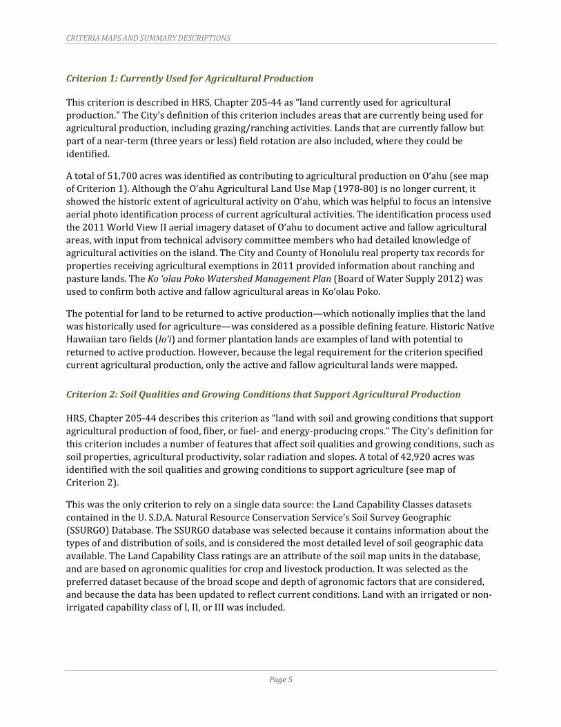
CRITERIAMAPSANDSUMMARYDESCRIPTIONS
Page5
Criterion1:CurrentlyUsedforAgriculturalProduction
ThiscriterionisdescribedinHRS,Chapter205‐44as“landcurrentlyusedforagriculturalproduction.”TheCity’sdefinitionofthiscriterionincludesareasthatarecurrentlybeingusedforagriculturalproduction,includinggrazing/ranchingactivities.Landsthatarecurrentlyfallowbutpartofanear‐term(threeyearsorless)fieldrotationarealsoincluded,wheretheycouldbeidentified.
Atotalof51,700acreswasidentifiedascontributingtoagriculturalproductiononO‘ahu(seemapofCriterion1).AlthoughtheO‘ahuAgriculturalLandUseMap(1978‐80)isnolongercurrent,itshowedthehistoricextentofagriculturalactivityonO‘ahu,whichwashelpfultofocusanintensiveaerialphotoidentificationprocessofcurrentagriculturalactivities.Theidentificationprocessusedthe2011WorldViewIIaerialimagerydatasetofO‘ahutodocumentactiveandfallowagriculturalareas,withinputfromtechnicaladvisorycommitteememberswhohaddetailedknowledgeofagriculturalactivitiesontheisland.TheCityandCountyofHonolulurealpropertytaxrecordsforpropertiesreceivingagriculturalexemptionsin2011providedinformationaboutranchingandpasturelands.TheKo‘olauPokoWatershedManagementPlan(BoardofWaterSupply2012)wasusedtoconfirmbothactiveandfallowagriculturalareasinKo‘olauPoko.
Thepotentialforlandtobereturnedtoactiveproduction—whichnotionallyimpliesthatthelandwashistoricallyusedforagriculture—wasconsideredasapossibledefiningfeature.HistoricNativeHawaiiantarofields(lo‘i)andformerplantationlandsareexamplesoflandwithpotentialtoreturnedtoactiveproduction.However,becausethelegalrequirementforthecriterionspecifiedcurrentagriculturalproduction,onlytheactiveandfallowagriculturallandsweremapped.
Criterion2:SoilQualitiesandGrowingConditionsthatSupportAgriculturalProduction
HRS,Chapter205‐44describesthiscriterionas“landwithsoilandgrowingconditionsthatsupportagriculturalproductionoffood,fiber,orfuel‐andenergy‐producingcrops.”TheCity’sdefinitionforthiscriterionincludesanumberoffeaturesthataffectsoilqualitiesandgrowingconditions,suchassoilproperties,agriculturalproductivity,solarradiationandslopes.Atotalof42,920acreswasidentifiedwiththesoilqualitiesandgrowingconditionstosupportagriculture(seemapofCriterion2).
Thiswastheonlycriteriontorelyonasingledatasource:theLandCapabilityClassesdatasetscontainedintheU.S.D.A.NaturalResourceConservationService’sSoilSurveyGeographic(SSURGO)Database.TheSSURGOdatabasewasselectedbecauseitcontainsinformationaboutthetypesofanddistributionofsoils,andisconsideredthemostdetailedlevelofsoilgeographicdataavailable.TheLandCapabilityClassratingsareanattributeofthesoilmapunitsinthedatabase,andarebasedonagronomicqualitiesforcropandlivestockproduction.Itwasselectedasthepreferreddatasetbecauseofthebroadscopeanddepthofagronomicfactorsthatareconsidered,andbecausethedatahasbeenupdatedtoreflectcurrentconditions.Landwithanirrigatedornon‐irrigatedcapabilityclassofI,II,orIIIwasincluded.
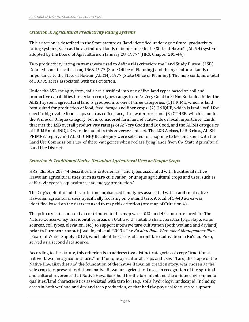
CRITERIAMAPSANDSUMMARYDESCRIPTIONS
Page6
Criterion3:AgriculturalProductivityRatingSystems
ThiscriterionisdescribedintheStatestatuteas“landidentifiedunderagriculturalproductivityratingsystems,suchastheagriculturallandsofimportancetotheStateofHawai‘i(ALISH)systemadoptedbytheBoardofAgricultureonJanuary28,1977”(HRS,Chapter205‐44).
Twoproductivityratingsystemswereusedtodefinethiscriterion:theLandStudyBureau(LSB)DetailedLandClassification,1965‐1972(StateOfficeofPlanning)andtheAgriculturalLandsofImportancetotheStateofHawaii(ALISH),1977(StateOfficeofPlanning).Themapcontainsatotalof39,795acresassociatedwiththiscriterion.
UndertheLSBratingsystem,soilsareclassifiedintooneoffivelandtypesbasedonsoilandproductivecapabilitiesforcertaincroptypesrange,fromA:VeryGoodtoE:NotSuitable.UndertheALISHsystem,agriculturallandisgroupedintooneofthreecategories:(1)PRIME,whichislandbestsuitedforproductionoffood,feed,forageandfibercrops;(2)UNIQUE,whichislandusefulforspecifichigh‐valuefoodcropssuchascoffee,taro,rice,watercress;and(3)OTHER,whichisnotinthePrimeorUniquecategory,butisconsideredfarmlandofstatewideorlocalimportance.LandsthatmettheLSBoverallproductivityratingsofA:VeryGoodandB:Good,andtheALISHcategoriesofPRIMEandUNIQUEwereincludedinthiscoveragedataset.TheLSBAclass,LSBBclass,ALISHPRIMEcategory,andALISHUNIQUEcategorywereselectedformappingtobeconsistentwiththeLandUseCommission’suseofthesecategorieswhenreclassifyinglandsfromtheStateAgriculturalLandUseDistrict.
Criterion4:TraditionalNativeHawaiianAgriculturalUsesorUniqueCrops
HRS,Chapter205‐44describesthiscriterionas“landtypesassociatedwithtraditionalnativeHawaiianagriculturaluses,suchastarocultivation,oruniqueagriculturalcropsanduses,suchascoffee,vineyards,aquaculture,andenergyproduction.”
TheCity’sdefinitionofthiscriterionemphasizedlandtypesassociatedwithtraditionalnativeHawaiianagriculturaluses,specificallyfocusingonwetlandtaro.Atotalof5,440acreswasidentifiedbasedonthedatasetsusedtomapthiscriterion(seemapofCriterion4).
TheprimarydatasourcethatcontributedtothismapwasaGISmodel/reportpreparedforTheNatureConservancythatidentifiesareasonO‘ahuwithsuitablecharacteristics(e.g.,slope,watersources,soiltypes,elevation,etc.)tosupportintensivetarocultivation(bothwetlandanddryland)priortoEuropeancontact(Ladefogedetal.2009).TheKo‘olauPokoWatershedManagementPlan(BoardofWaterSupply2012),whichidentifiesareasofcurrenttarocultivationinKo‘olauPoko,servedasaseconddatasource.
Accordingtothestatute,thiscriterionistoaddresstwodistinctcategoriesofcrop:“traditionalnativeHawaiianagriculturaluses”and“uniqueagriculturalcropsanduses.”Taro,thestapleoftheNativeHawaiiandietandthefoundationofthenativeHawaiiancreationstory,waschosenasthesolecroptorepresenttraditionalnativeHawaiianagriculturaluses,inrecognitionofthespiritualandculturalreverencethatNativeHawaiiansheldforthetaroplantandtheuniqueenvironmentalqualities/landcharacteristicsassociatedwithtarolo‘i(e.g.,soils,hydrology,landscape).Includingareasinbothwetlandanddrylandtaroproduction,orthathadthephysicalfeaturestosupport
CRITERIAMAPSANDSUMMARYDESCRIPTIONS
Page7
futuretaroproduction,wasconsideredasapossibledefiningfeature.Duetothelackofavailabledatasources,drylandtaroareaswerenotidentified,andthecriterionwasdefinedtoincludeonlylandcurrentlyinwetlandtaroproductionandlandhistoricallysuitabletosupportwetlandtaroproductionpriortowesterncontact.Furthermore,itwasnotpossibletomapanyoftheothertraditionalnativeHawaiiancropsbecauseofthelackofinformationaboutthepreciselocationswheresuchcropsweregrown.Nouniquecropsweremappedbecauseatthetimeofthemapping,therewerenoniche‐marketcropsknowntobegrowinginnon‐traditionalconditionsthatcouldbedefinedasa“unique”crop.
Criterion5:WatertoSupportViableAgriculturalProduction
HRS,Chapter205‐44listsCriterion5as“landwithsufficientquantitiesofwatertosupportviableagriculturalproduction.”TheCity’sdefinitionofthiscriterionconsistedoflandprovidedwithcurrentorrecentaccesstowaterforagriculturalproduction,includingWaterResourcesManagement(CWRM)WaterUsePermits,agriculturalwateravailablethroughtheBoardofWaterSupply(BWS),orirrigationviasurfacewaterditchsystems.Mappingthedefiningfeaturesofthiscriterionreliedoninformationfromprivatelandownersandvariousstateandcountyagencies.Datasourcesinclude:
1. CWRMWaterUsePermits(Sincewaterusepermitsareassignedtotaxmapkey(TMK)parcels,theparcelsthatwereidentifiedashavingapermitwereincludedinthedataset.)
2. BWSinventoryofTMKparcelsreceivinganagriculturalwaterrate
3. CWRMirrigationsystemdatafortheWahiawāReservoirDitch2Systemservicearea
4. DOAirrigationsystemdatafortheWaiāholeDitchSystemservicearea,WaimānaloDitchSystemservicearea,andtheWahiawāDitchSystemservicearea
5. KamehamehaSchoolsirrigationsystemdataforPunalu‘u
6. DoleFoods’irrigationsystemdatafortheirNorthShoreandWahiawālands(whichincludedmostofKamehamehaSchools’NorthShorelands)
7. IrrigationsystemdataforlandformerlyownedbytheCampbellEstateinKahuku.
Atotalof33,465acreswereidentifiedashavingaccesstowaterforagriculturalproduction(seemapofCriterion5).Whilethestatutespecifiesthatthiscriterionidentify“landwithsufficientquantitiesofwatertosupportviableagriculturalproduction,”theCitysimplifiedtherequirementsothataccesstowaterwasenoughtobeconsidered“sufficient,”largelybecausetheamountofwaterinvolvedindeterminingsufficiencyisspecifictothetypeofcropbeinggrown(i.e.,irrigationrequirementsvarydependingoncroptype).Determiningsufficiencybasedonaknownquantityofavailablewaterismoreapplicabletothevoluntary(privatelandowner)designationprocesswherethecriterionisappliedtoindividualparcelswithspecificcropandirrigationrequirements.
Thepossibilityofmeasuringtheformoftransmission(i.e.,viagravityfloworpumped)andthesourceofthewater(i.e.,groundwater,recycledwaterorsurfacecollection)wasconsideredbecauseaccesstowaterisonlyonefactorthatcontributestotheavailabilityofwater.GiventhatthepurposeofIAListomakefarminganeconomicallyviableactivity,itwasreasonabletoconsidertheattributesofthewatersourceandthetransmissionsystem—includingthequalityofwater

CRITERIAMAPSANDSUMMARYDESCRIPTIONS
Page8
availableforuseandthelevelofeffortrequiredtotransportwater—thataffecttheoverallcostofwaterandthetypeofcropsthatcanbegrown.Forexample,waterfromtheWahiawāReservoirDitchisratedR‐2,whichissecondarytreatedrecycledwaterthathasuserestrictionswithcertainfoodcrops.Similarly,theconditionoftheirrigationsystemandthecostsinvolvedinmaintainingthesystemcontributetotheoverallcostofprovidingwater.Emphasizingtheneedtobeasinclusiveaspossiblewiththemappingeffort,theCitydecidedthataccesstowaterwasadequate.
Criterion6:ConsistentwithCountyPlans
HRS,Chapter205‐44liststhiscriterionas“landwhosedesignationasIALwouldbeconsistentwithgeneral,developmentandcommunityplansofthecounty.”Unliketheothercriteriathatwereopentointerpretation,thiscriterionwaspre‐determinedandclearlydefinedbythestatute.TheCity’sdefinitionofthiscriterionincludedlandthatsatisfiedbothconditions:(1)designatedforagriculturalusebyapproved(i.e.,adoptedbytheCityCouncil)DevelopmentPlansandSustainableCommunitiesPlans;and(2)zonedeitherAG‐1:RestrictedAgriculturalorAG‐2:GeneralAgricultural.RelationshiptotheDP/SCPcommunitygrowthboundarywasnotaconditionforthiscriterion.Atotalof59,870acreswereconsideredtobeconsistentwithcountyplans(seemapofCriterion6).
Criterion7:ContributestoMaintainingaCriticalLandMass
HRS,Chapter205‐44describesthiscriterionas“landthatcontributestomaintainingacriticallandmassimportanttoagriculturaloperatingproductivity.”
Thiscriterionwasnotmapped,largelybecausethephysicalattributesthatillustratetheconceptofcriticallandmass—theproximitytoadjacentagriculturallandsandotherlandswithecologicalfunctionsimportanttothevalueofagriculture—couldnotbequantifiedortranslatedintoameasureablefactor.Severalpossiblescenariosthatcouldformabasisformeasurementwereconsidered,including:(1)acertainnumberoffarmsoperatinginclosevicinitytoeachother;(2)apre‐determinedacreageofcontiguouslandwithsimilarfunctions(i.e.,thecriticallandmassformedbylandthatmeetscertainecologicalorphysicalcharacteristics);and(3)apre‐determinedacreageofcontiguousagriculturalland(i.e.,thecriticallandmassformedbyanundividedacreageofagriculturalland).
TheCitydeterminedthatquantifyingthiscriterionasanumericvaluewasnotappropriateforthecounty’smappingprocessforseveralreasons.First,usingaspecificacreagetodefinecriticallandmassdoesnotprotectagriculturalareasfromurbanencroachment,oraddresstheneedtominimizeconflictsbetweenadjacenturbanandagriculturalactivities(e.g.,odor,noise,dustandothernuisancecomplaintsthattypicallyoccurfollowingurbanusesencroachingintoagriculturalareas).Second,farmacreageshouldbeasufficientsizetoallowforcroprotation,whichisanecessaryfunctionoffarming.Giventhatfarmsvaryinsize(fromlessthananacretothousandsofacres),thereisuncertaintyabouthowtodefinethiscriterioninawaythatdoesnotexcludethesmallerfarms.Finally,determiningcriticallandmassinvolvessubjectivereviewofsurroundingurbanuses,whichseemsmoreappropriatewhenevaluatingvoluntary(privatelandowner)petitionsthanthecountydesignationprocess.

CRITERIAMAPSANDSUMMARYDESCRIPTIONS
Page9
Criterion8:WithorNearSupportInfrastructure
HRS,Chapter205‐44liststhiscriterionas“landwithornearsupportinfrastructureconducivetoagriculturalproductivity,suchastransportationtomarkets,water,orpower.”TheCity’sdefinitionofthiscriterionemphasizedthedegreeofaccessibility(i.e.,thedistanceanddifficultyofaccess)betweenfarmsandinfrastructuresystems,includingroads,harbors,airports,potablewaterandelectricalinfrastructuresystems.
ThiscriterionwasnotmappedbecauseaccessingtransportationandinfrastructuresystemsaresecondaryconsiderationsforO‘ahufarmerswhencomparedtoconditionsontheneighborislands.TheentireislandofO‘ahuwasdeterminedtohaveequalstatuswithregardtoaccesstotransportation,marketsandinfrastructuresystems,asO‘ahufarmsareclosesttotheState’smajormarketsandhavereasonableaccesstopublicroadways,harborsandairportsunlikefarmsontheotherislandsthatrelyonadditionalshippingtotransportproductstomarket.Forexample,farmsinremoteplacessuchasMoloka‘iorHawai‘iIslandwouldrequireadditionalshipping(viabargeorairtravel)totransportproductstomarket.Similarly,currentutilitynetworksonO‘ahuaremorerobustandreadilyavailablethanontheotherislands.Accessibilitytocountywatersystemsandelectricalgenerationsources(includingphotovoltaicsystems)werenotconsideredtobemajorimpedimentsforO‘ahu,giventheextentofcurrentutilitynetworks.Whilethecostsassociatedwithinstallingpotablewaterandelectricalserviceinstallationsmayinfluencealandowner’sabilitytodevelopsuchfacilities,itdoesnotaffectthedegreeofaccessibilitytosuchsystems.
Criterion9:AgriculturalEasements
AninthcriterionthatrecognizedpropertieswithagriculturaleasementswasaddedatthediscretionoftheCityanditspaneloftechnicaladvisorsinordertoprovidelandownerswithagriculturaleasementsaccesstotheIALincentives.Thiscriterionfocusedsolelyonagriculturaleasementsthatprovideforperpetualagriculturallanduse;propertieswithrestrictivecovenantsorunilateralagreementswereexcluded.
Atotalof1,280acreswithprotectiveagriculturaleasementswasidentified(seemapofCriterion9).Threespecificprogramsthatwereincludedinthisinventoryinclude:(1)StateofHawai‘iLegacyLandsConservationProgram;(2)HawaiianIslandsLandTrust;and(3)theUSDA‐NRCSFarmandRanchLandsProtectionProgram.