Embed Size (px)
Citation preview
1
CSIS Discussion Paper #27
Fluvial Geomorphology and Paleohydrology in Japan
Takashi Oguchi a, Kyoji Saito b, Hiroshi Kadomura c, and Michael Grossman d
a Center for Spatial Information Science, University of Tokyo, c/o Department of Geography,
Faculty of Science, 7-3-1, Hongo, Bunkyo-ku, Tokyo 113-0033, Japan
b Department of Geography, Faculty of Education, Saitama University, Shimo-Okubo, Urawa 338-
8570, Japan
c Department of Environment Systems, Faculty of Geo-Environmental Science, Rissho University,
1700 Magechi, Kumagaya 360-0194, Japan
d Department of Geography, University of Wisconsin-Madison, Madison, Wisconsin 53706, USA
Abstract
An introduction to fluvial geomorphology and paleohydrology in Japan is provided for researchers who
are unfamiliar with these topics. Studies by Japanese geomorphologists are reviewed including those
published only in Japanese-language journals. Emphasis is placed upon the following aspects: 1) abundant
sediment yields from steep watersheds subjected to frequent heavy rains despite heavily vegetated
conditions, 2) extensive sedimentation in mountain piedmonts and coastal fluvial plains especially during
the Holocene, 3) catastrophic hydro-geomorphological events associated with earthquakes and volcanic
eruptions, and 4) the impacts of the increased heavy rainfall during the Pleistocene--Holocene transition on
the post-glacial development of hillslopes and alluvial fans. These geomorphological characteristics differ
from those in continental regions such as Europe and North America indicating that research on Japanese
fluvial systems can contribute a great deal to understanding the global variety of fluvial geomorphology.
Recent work on paleohydrological reconstruction in Japan is also reviewed.
1. Introduction
Fluvial processes have been shown to be highly variable according to physiographic setting and climate
(e.g., Miller and Gupta, 1999), and knowledge of present fluvial processes is an important basis for
paleohydrological investigations. However, the literature on paleohydrological research (e.g., Starkel et al.,
1991; Gregory et al., 1995; Branson et al., 1996) has not included substantial reference to recent research
on Japan. This deficiency has arisen because it is only comparatively recently that Japanese
geomorphological studies have appeared in the international literature with an increasing number of studies
published in English-language scientific journals. Therefore, the basic idea that the dominant fluvial
processes in Japan are very different from those in most other regions of the world such as North America
and Europe is not well known internationally. The Japanese Islands have a unique combination of
geomorphologic and climatic features including steep and rugged watersheds and frequent heavy rains
which result in rapid geomorphological changes. In addition, the landscape of Japan experienced a marked
increase in erosive force during the Pleistocene--Holocene climatic shift, a phenomena which still strongly
affects the modern landscape.
This paper provides a review of these uniquely Japanese aspects of fluvial geomorphology and
2
paleohydrology based mainly on studies by Japanese geomorphologists in order to add new insights into
the regional variety of fluvial processes. Although one major book in English on the geomorphology of
Japan has already been published (Yoshikawa et al., 1981), it emphasized tectonic landforms rather than
fluvial processes. In addition, this book does not reflect publications which have appeared in the last two
decades although new geomorphological concepts and models have been developed in Japan during this
period.
2. Geomorphological and hydrological characteristics of Japanese watersheds
2.1 Steep watersheds
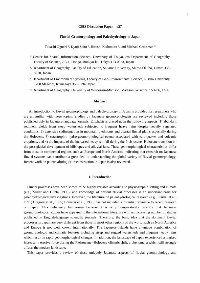
The relief of watersheds in Japan is generally much greater than that of watersheds in other parts of the
world. Figure 1 shows the distribution of the major drainage systems in Japan. The high relief of
watersheds in Japan is due to the following characteristics of the Japanese Islands: 1) the island chain is
characterized by a narrow and elongated shape with mountains and hilly lands occupying a large
percentage of the land; 2) the major mountain ranges are located along the backbones of the islands; and 3)
the mountains ranges are often bordered by faults with high vertical displacement rates or are heavily
deformed by tight folds with short wave lengths (Research Group for Quaternary Tectonic Map, 1968;
Kaizuka, 1987; Research Group for Active Faults of Japan, 1991). Consequently, Japanese mountains have
high relief despite their relatively small width. For example, the Kiso Mountains in central Japan have a
relative relief of ca. 2,000 m although their width is only about 15 km. Rivers flowing from the summits of
Japanese mountain ranges tend to flow perpendicularly to the orientation of the ranges. Consequently, most
Figure 1 Drainage systems and major divides in Japan.
Stream nets were taken from vector GIS data in Digital Chart of the World CD-
ROMs provided by ESRI, Redlands, USA.
3
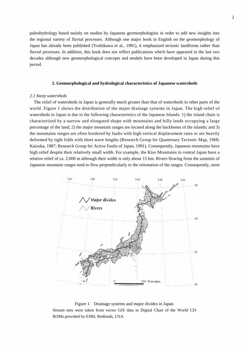
major rivers in Japan have very steep profiles. Figure 2 presents the longitudinal profiles of some major
rivers in Japan and some major rivers in other countries for downstream areas including the lowermost
reaches facing the ocean. This figure illustrates the relative steepness of Japanese rivers. Although the
Shinano River (Figure 2) is the longest river in Japan, its gradient is still greater than most of the rivers in
other countries.
Figure 2 Longitudinal profiles of Japanese rivers (without asterisks before names) and rivers
in other countries (with asterisks) for downstream areas including the lowermost reaches
facing the ocean (Takahashi and Sakaguchi, 1976)
There is an story often told among Japanese geomorphologists. In 1891, the Japanese government
invited a Dutch river engineer, J. De Rike to consult about a plan for erosion control. This was during one
of the earliest visits by a western researcher to Japan related to fluvial geomorphology. When De Rike
visited the Joganji River in central Japan (the steepest river in Figure 2), he was surprised and said, "This
is not a river but a cataract!"
Steep Japanese watersheds are characterized not only by high-gradient streams but also by steep valley-
side slopes. For example, most of the hillslopes in the Japan Alps, the highest non-volcanic ranges in Japan,
have a modal angle of about 35 degrees (Katsube and Oguchi, 1999).
2.2 Heavy storms
Japanese watersheds are frequently affected by very heavy storms. Matsumoto (1993) examines the
global distribution of daily maximum precipitation records noting that most of the Japanese Islands and
their surroundings have experienced a daily precipitation of more than 300 mm at least once since the
beginning of modern meteorological observations. Some of the Japanese meteorological stations have
records of daily precipitation of more than 1,000 mm. Sustained maximum daily rainfall at this level has
seldom been recorded in Europe or North America. Two factors account for such heavy storms in Japan:
4
typhoons and the Polar front. Typhoons usually affect Japan between August and October and often cause
very intense rainfall. The Polar front persists over Japan generally in June and July, a period which is the
main rainy season (Bai-u). In most of Japan, typhoons are responsible for the heaviest storms (Mizukoshi,
1965). In western Japan, however, the Polar front sometimes plays a role equivalent to typhoons, especially
when warm and wet winds from the south blow into the front inducing heavy rainfall. Statistical analyses
of climatological data show that the recurrence interval of rainfall exceeding 50 mm/hr or 200 mm/day is
about ten years in most of Japan (Iwai and Ishiguro, 1970).
2.3 Frequent slope failures and landslides
The combination of steep watersheds and frequent heavy storms in Japan results in widespread hillslope
failures and landslides. These processes account for most of the sediment production from Japanese
mountains (Tsukamoto, 1973). Surveys on hillslopes in steep ranges in central Japan reveal that the
majority of hillslope units were created by slope failures, landslides, and the resultant gullying (Moriya,
1972; Oguchi, 1996a). Factors triggering slope failures and landslides in Japan have been investigated by
civil engineers and erosion-control researchers as these events often cause serious hazards. Results indicate
that these processes tend to be activated when rainfall intensity exceeds 50 mm/hr or 100 to 200 mm/day
(Ishihara et al., 1976; Tanaka, 1977; Michiue and Kojima, 1980). As noted, this threshold rainfall level
occurs about once in ten years in most of Japan. Therefore, slope failures and landslides repeatedly occur in
Japanese watersheds producing an abundant sediment supply (Oguchi, 1996b).
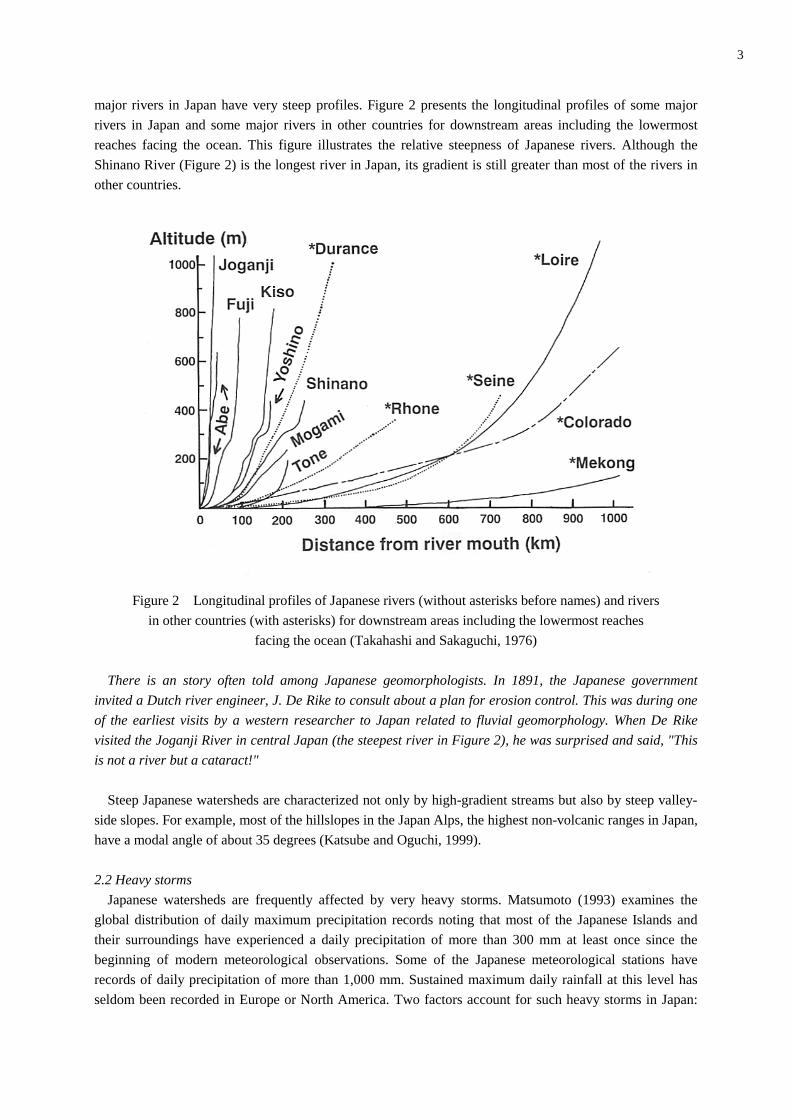
Figure 3 Slope failures in the Kusari River basin, the Northern Japan Alps, central Japan.
It has been pointed out that humid regions in the world are characterized by lower sediment production
than semi-arid regions due to the protective effects of thick vegetation (e.g., Langbein and Schumm, 1958;
Chorley et al., 1984; Inbar, 1992). In Japan, however, slope failures and landslides can easily occur on
densely forested hillslopes because vegetation and slope deposits can move together when steep and
unstable hillslopes are subjected to heavy rains (Ohmori, 1983). After the occurrence of slope failures and
landslides, wet and temperate climatic conditions facilitate rapid vegetation recovery on hillslopes. This
5
mechanism accounts for the co-existence of high sediment production and dense vegetation cover in
Japanese mountains (Figure 3).
The frequent occurrence of slope failures and landslides also affects the structure of stream nets in Japan.
In steep Japanese mountains, the Horton parameters such as the bifurcation ratio (Rb) and the stream length
ratio (Rl) have different values (mean Rb = 4.5, mean Rl = 1.9) from those in less steep Japanese mountains
(mean Rb = 4.0, mean Rl = 2.4) and from those in mountains in other countries (mean Rb = 3.7, mean Rl =
2.6) due to active stream creation and elongation on valley-side slopes by slope failures and landslides
(Inoue and Oguchi, 1995). Relationships between relative relief and drainage density in steep Japanese
mountains also reflect the effects of slope failure on the side walls of channels (Oguchi, 1997a).
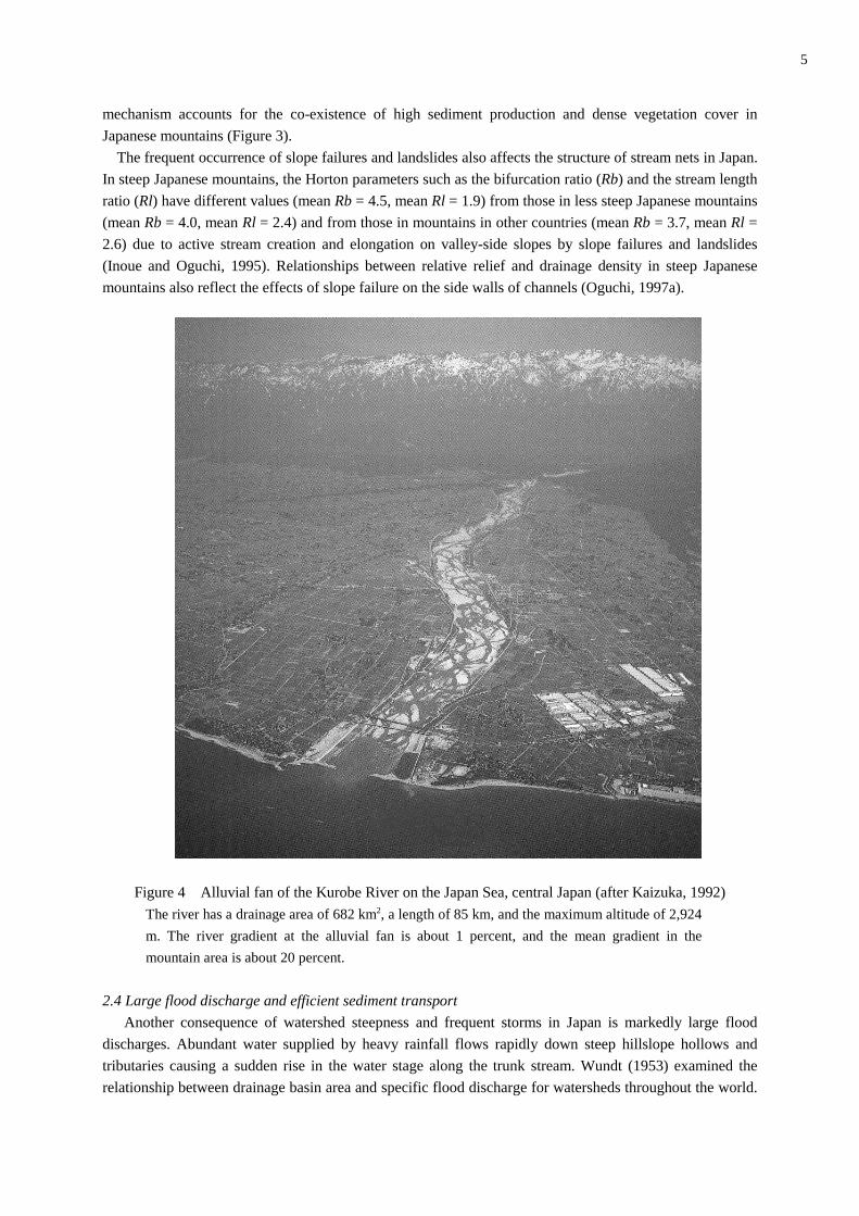
Figure 4 Alluvial fan of the Kurobe River on the Japan Sea, central Japan (after Kaizuka, 1992)
The river has a drainage area of 682 km2, a length of 85 km, and the maximum altitude of 2,924
m. The river gradient at the alluvial fan is about 1 percent, and the mean gradient in the
mountain area is about 20 percent.
2.4 Large flood discharge and efficient sediment transport
Another consequence of watershed steepness and frequent storms in Japan is markedly large flood
discharges. Abundant water supplied by heavy rainfall flows rapidly down steep hillslope hollows and
tributaries causing a sudden rise in the water stage along the trunk stream. Wundt (1953) examined the
relationship between drainage basin area and specific flood discharge for watersheds throughout the world.
6
Data for Japan plotted on his diagram fall within the zone of the "possible maximum flood discharge" for a
given drainage basin area (Takahashi and Sakaguchi, 1976). For example, in a Japanese watershed with a
1,000 km2 area, specific flood discharge is between 2 and 20 m3/s/km2, equivalent to the largest rainfall-
runoff floods in the world as compiled by Costa (1987), and much larger than the discharge found in most
watersheds of the same size in other countries.
In addition, the duration of floods in Japan is short because of rapid water drainage along steep reaches.
It is usual for flooded rivers to return to their normal conditions within one or two days. Therefore, the
coefficient of river regime, defined as the ratio of the annual maximum discharge to the annual minimum
discharge, is large for Japanese rivers (normally between 100 and 1000), but small for rivers in continental
regions (normally less than 100). Although floods in Japan are of relatively short duration, they are often
capable of flushing sediments downstream due to their high peak discharges.
Debris flows also play a significant role in sediment transport in steep watersheds. When sediments
produced by slope failures contain abundant water, they become a debris flow. The flow grows in volume
by picking up sediments and water on river beds. A debris flow can also start from water-saturated
sediments on river beds, especially when the river gradient is greater than fifteen degrees. A debris flow
stops when the river gradient decreases to about three degrees. Normal flood flow is responsible for further
sediment transportation to downstream areas (Shimazu, 1991, 1994).
In most cases, sediments produced by slope failures and landslides are transported to mountain
piedmonts in a relatively short time, probably within a few tens of years. Therefore, thick valley fill
deposits of recent periods are rare in Japanese mountains, except in some places which have experienced
enormous sediment supply due to large and catastrophic landslides (Machida, 1966; Shimazu and Oguchi,
1996). In other words, long-term sediment storage within most mountain watersheds in Japan is negligible
under the present climatic conditions.
The ratio of bedload to total load transported by Japanese rivers often reaches 0.6 to 0.8 (e.g., Ashida
and Okumura, 1974; Ohmori, 1991; Oguchi, 1997b). This ratio is significantly higher than that of rivers in
other countries. The abundant supply of clastic materials from hillslopes and the notably large flood
discharges are responsible for the large percentage of bedload. Abundant coarse gravels on river beds also
result in the broad distribution of braided channels in Japan (Figure 4).
2.5 High sediment yields
Abundant sediment supply from hillslopes and efficient sediment transport along streams result in
markedly high sediment yields from Japanese watersheds. Yoshikawa (1974) estimated sediment yields
from Japanese mountainous watersheds using sedimentation rates in reservoirs. The results indicate that
sediment yields from steep watersheds often exceed 1,000 m3/km2/yr with a maximum of more than 10,000
m3/km2/yr. These values are equivalent to the global maximum sediment yields recorded in some Asian
mountainous watersheds (e.g., Milliman and Syvitski, 1992), and are much higher than sediment yields
from most watersheds in the world (e.g., Ohmori, 1983).
There is an interesting story related to this observation. When Yoshikawa presented the estimated
sediment yields from Japanese watersheds at a conference of the International Geographical Union in
1972, most of the audience from foreign countries thought that the values were too large. One of them
claimed that the presented values could be 10 times larger than actual values, suspecting that Yoshikawa
made a mistake in the order of magnitude of the figure. However, Andre Rapp from Sweden, who was
recognized as a leading researcher on sediment yields, supported Yoshikawa's calculation. He had visited
Taiwan and he knew that rivers there transported extremely large volumes of sediment. This episode shows
that the very large sediment yields from watersheds in Japan as well as in Taiwan (e.g., Li, 1976) were
7
difficult to believe for researchers who had not visited the steep watersheds in these countries.
Milliman and Syvitski (1992) indicate that some watersheds in South and Southeast Asian countries such
as Thailand, the Philippines, Papua New Guinea and India show sediment yields comparable to Japan and
Taiwan (Note that the Japanese examples in Milliman and Syvitski’s paper point to relatively low sediment
yields; however, these examples are not as representative as those introduced by Yoshikawa). Such high
sediment yields in South and Southeast Asian countries, however, may be significantly accelerated by
human activities in the 20th century (Walling, 1996). By contrast, mean erosion rates in Japan during the
Holocene are comparable to present erosion rates suggesting that very rapid erosion can occur under natural
conditions without human disturbances (Oguchi, 1996c). Adams (1980) also points to very high erosion
rates in some mountain watersheds in New Zealand since the Late Glacial based on sedimentation rates in
lakes. Both Japan and New Zealand are characterized by high-relief mountains on active margins, and by
storms due to tropical cyclones, suggesting that these two factors are the major driving forces for the
world’s highest levels of sediment yields under natural conditions.
2.6 Catastrophic hydro-geomorphological events associated with earthquakes and volcanic eruptions
Although heavy storms and floods are most responsible for the rapid production, transportation and
accumulation of sediments in Japanese watersheds, catastrophic events associated with tectonic and
volcanic activities along the plate margin sometimes play a significant role in fluvial processes in Japan.
Earthquakes in mountainous areas, with magnitudes larger than about 6 on the Richter Scale, often trigger
slope failures and subsequent debris flows. An extraordinarily large-scale landslide and debris flow on the
Kiso-Ontake Volcano (3063 m) in central Japan is a typical recent example. This single event triggered by
the shock of the 1984 Naganoken-Seibu Earthquake (M 6.8) yielded a huge amount of sediment (ca.
3.6×10⁷ m3) (e.g., Moriya, 1985; Oguchi et al., 1998).
Earthquake-induced slope failures and debris flows often create natural dams with extensive ponded
water. Failures of these dams have resulted in catastrophic flooding in downstream areas. Two typical
events occurred in central Japan, induced by the 1847 Zenkoji Earthquake (M 7.4) on the Sai River (Ito,
1983; Oguchi et al., 1998) and by the 1858 Hietsu Earthquake (M 7.1) on the Joganji River (e.g., Machida,
1966; Ouchi and Mizuyama, 1989). The latter event yielded a huge amount of sediment totaling ca.1.3 to
2×10⁸ m3, resulting in tragic flood damage due to the failure of landslide dams. Heavily debris-loaded,
devastated river channels also posed serious erosion and flood control problems.
At present, 86 volcanoes in the Japanese Islands have been designated active volcanoes by the Japan
Meteorological Agency. Some of these volcanoes have experienced very rapid erosion and mass
movements during or immediately after eruptions in the recent past. During the 1991-1994 eruptive
activities of Unzen-Fugendake Volcano (1359 m), western Kyushu, pyroclastic flows frequently occurred
due to the collapse of extruded lava domes on the summit. These flows were followed by a series of rain-
triggered debris flows spreading onto the piedmont alluvial fan (e.g., Kadomura and Chinen, 1995; Jones
and Ui, 1999). The amount of sediment transported by a single storm event was on the order of 104 to 105
m3 and the volume of accumulated sediment exceeded 108 m3. On Sakurajima Volcano (1117 m), southern
Kyushu, completely denuded upper-middle slopes due to persistent ash eruptions since 1955 have
repeatedly supplied rain-triggered debris flows. Coupled with the frequent occurrence of heavy convective
showers produced by the orographic effect of the volcano itself, the most active river on the volcano has
experienced 20 to 30 debris-flow events every year (Kadomura and Chinen, 1995). The 1977-1978 eruption
of Usu Volcano (727 m) in Hokkaido was also followed by accelerated hillslope erosion and frequent rain-
triggered mass movements. In this cold snowy region, snow avalanches and sudden thawing were also
responsible for triggering mass movements. A detailed description and the sequence of
8
hydrogeomorphological events at Usu Volcano have been documented by Kadomura et al. (1983a, 1983b).
It should be emphasized that the minimum amount of rainfall needed to trigger large-scale debris flows on
these volcanoes was generally small, 10-15 mm for one hour intensity and 20-30 mm for continuous
rainfall. This is due to the ash cover reducing the permeability of the land surface, and to the high
erodibility and/or instability of newly deposited ejecta and lava boulders.
Although earthquakes and volcanic eruptions often lead to drastic geomorphological changes lasting a
certain period of time, the effects of tectonic and volcanic activities on the long-term development of
fluvial landforms in Japan are thought to be limited. Until the 1960s’, many Japanese geomorphologists
believed that the development of fluvial landforms in Japan during the late Quaternary was strongly
influenced by tectonic activities. Since the 1970s’, however, the precise dating of fluvial surfaces based
mainly on tephrochronology, which is widely applicable to Japan, has revealed that the major trends of
fluvial erosion and deposition in the upstream area correspond to climatic change; whereas, in the
downstream area, they correspond to eustatic sea-level changes (e.g., Ono and Hirakawa, 1975; Toyoshima,
1984; Kadomura, 1987; Oguchi, 1988). Therefore, recent books on alluvial fans and coastal plains in Japan
put emphasis on climatic and eustatic controls on the development of geomorphic surfaces (Saito, 1988;
Umitsu, 1994). Although models have been proposed to ascribe the variety of fluvial landforms to different
tectonic settings (e.g., Bull, 1977; Keller and Pinter, 1996), these models may not be applicable to most of
Japan despite its location in a tectonically active zone, because rivers under different tectonic settings have
experienced similar modes of erosion and deposition in the late Quaternary.
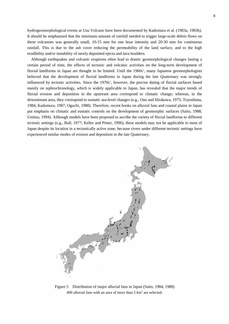
Figure 5 Distribution of major alluvial fans in Japan (Saito, 1984, 1988)
490 alluvial fans with an area of more than 2 km2 are selected.
9
3. Sedimentation in the lowlands
3.1 Alluvial fans at mountain piedmonts
Abundant sediment supply from Japanese mountains results in the widespread distribution of alluvial
fans along the mountain fronts. Toya et al. (1971) and Saito (1984, 1988) provide a list of alluvial fans in
Japan. The number of large fans with an area of more than 2 km2 is 490 (Figure 5), although the total
surface area of the Japanese Islands is smaller than that of the state of California, USA. Smaller alluvial
fans, which are called "alluvial cones" in Japan, also occur widely in mountains and hilly areas. River
terraces in valleys are often covered with alluvial cones due to sediment supply from valley-side slopes and
tributaries (e.g., Iso et al., 1980). Both alluvial fans and alluvial cones consist mostly of gravel and sand but
they can also contain boulders when debris flows contribute to their formation.
Although many publications, including textbooks, indicate that alluvial fans typically occur in arid and
semi-arid regions (e.g., Chorley et al., 1984), fan density in Japan is probably comparable to or even greater
than fan density in most arid regions. The probability of alluvial fan occurrence at mountain piedmonts
increases with mountain relief because of increased sediment supply (Saito, 1986, 1999). The area of fans
in Japan also tends to increase in direct proportion to annual sediment yields from source areas (Oguchi and
Ohmori, 1994).
Alluvial fans in Japan can be classified into two basic types: dissected and undissected. Most dissected
fans are composed of late Pleistocene surfaces; whereas, most undissected fans are composed of Holocene
surfaces (Saito, 1988). The distribution of fan surfaces formed in the mid-Pleistocene or earlier is much
more limited. Well-preserved old surfaces are confined to areas where fan surfaces are being tilted rapidly
toward fan apexes because of the relative uplift of fan toes. Alluvial fans in the Ina Valley, central Japan,
are typical examples of this type. Their incised features, due to the rapid uplift of fan toes induced by a
low-angle thrust fault (Ikeda, 1990), are referred to as "fan terraces" (Ono, 1990).
As noted above, sediment storage within mountainous watersheds in Japan can be negligible. In
intermontane basins; however, considerable volumes of sediments have been stored as alluvial fan deposits
or basin fills. The thickness of Holocene fan deposits sometimes reaches a few tens of meters (e.g., Saito,
1988; Oguchi, 1997b). Such large sediment storage in intermontane basins accounts for a reduced sediment
supply to downstream areas. Therefore, alluvial fans below intermontane basins tend to be smaller than
normal fans (Saito, 1988).
Saito (1984, 1988) provides not only a list of alluvial fans in Japan but also geomorphological and
geological data for the fans and their source areas. He carried out various statistical analyses to examine the
factors affecting the distribution of alluvial fans (e.g., Saito, 1988, 1990, 1993), and his approach has also
been adopted by researchers in Taiwan, where the large sediment supply from mountains also accounts for
the broad occurrence of alluvial fans (Chang et al., 1994, 1995).
3.2 Coastal fluvial plains
The effects of large sediment yields from upstream areas extend to the coastal areas of Japan. Coastal
fluvial plains occupy about 13 percent of the Japanese Islands, a value that is much larger than the world
average of 5 percent (Yoshikawa et al., 1981). Japanese coastal fluvial plains are also characterized by
thick sedimentation in the Holocene (Umitsu, 1994). Major lowlands, such as the Kanto Plain in and
around Tokyo, are underlain by Holocene deposits with thicknesses of several tens of meters (Kaizuka,
1969; Yoshikawa et al., 1981). Therefore, despite the sea level rise since the Last Glacial Maximum, large
estuaries are almost completely lacking in Japan (Kaizuka, 1969). Ria-type coasts are also confined to
limited areas such as the Sanriku Coast along the northern Pacific side of Honshu.
Oya (1973, 1995) and Oya et al. (1988) compiled geomorphological information about Japanese coastal

10
plains and indicated that the plains consist of three basic components: 1) an alluvial fan, 2) natural levees
with back swamps, and 3) a delta. They extend from 1) to 3) in a downstream direction. The boundary
between the alluvial fan and the natural-levee zone is characterized by sudden changes in both riverbed
gradient and grain sizes (Yatsu, 1955; Ohmori, 1991; Inoue, 1992) as well as in the distribution patterns of
micro-geomorphological units (Kadomura, 1966, 1971). The relative areal extent of each component within
a plain depends on sediment yields from upstream areas. Large sediment yields from source basins lead to
the expansion of alluvial fans (Oya, 1973; Yoshikawa et al., 1973). For example, the coastal fluvial plains
along the Fuji, Abe, Oi, Tenryu and Kurobe Rivers, flowing from the Japan Alps into the Pacific Ocean or
the Japan Sea, are almost entirely composed of alluvial fans, and thus fluvial gravel can be observed even
along the coast (Kadomura, 1966, 1968, 1971; Ouchi, 1979). These rivers remain braided down to their
river mouths (Figure 4). By contrast, rivers with intermontane basins in their middle reaches have smaller
coastal fans due to sediment storage in the basins (Oya et al., 1988).
Oya and his group also created detailed landform classification maps of some coastal plains in
Southeast Asia in relation to river management and flood mitigation. A classic textbook on fluvial
geomorphology by Leopold, Wolman, and Miller (1964) carries a part of Oya (1961)'s geomorphological
map of the Mekong Plain in Thailand, indicating that his work attracted international attention.
4. Responses of fluvial systems to Pleistocene--Holocene climatic change
4.1 Changes in storm intensity and hillslope processes
Although the Japanese Islands are currently subjected to very heavy storms and rapid hillslope erosion,
storm intensity was much lower around the time of the Last Glacial Maximum. The global southward shift
of frontal zones at that time resulted in infrequent visit by typhoons and the Polar front to the Japanese
Islands (Suzuki, 1971; Sugai, 1993). In other words, the two major factors causing contemporary heavy
storms in Japan played only a limited role around the time of the Last Glacial Maximum. This change in
storm intensity significantly affected hillslope development in Japan. As shown in Figure 3, hillslopes in
Japan often consist of two components: smooth slopes and incised slopes. They are bordered by the convex
breaks of slope. Hatano (1979) attributes this combination of slope units to the increase in storm intensity
during the Pleistocene--Holocene transition. He suggests that the smooth slopes were formed mainly by
freeze-thaw action during the Last Glacial age; whereas, incised slopes were formed by landslides and
gullying during the Holocene. Although this idea was proposed based mainly on air-photo interpretation, it
was confirmed by subsequent tephrochronological investigations on hillslope materials (e.g., Oguchi, 1988,
1994; Yanai, 1989). The shift in the mode of hillslope processes during the Pleistocene--Holocene
transition has also been recognized in other regions of Japan including northern to central Japan (e.g., Ono
and Hirakawa, 1975; Higaki, 1987; Miyagi, 1998) and the lowlands of western Japan where temperatures
during Last Glacial were relatively higher (Tanaka et al., 1982; Oguchi and Tanaka, 1998).
4.2 Effects of climatic change on fluvial processes
Changes in both storm intensity and hillslope processes during the Pleistocene--Holocene transition
affected hillslope sediment supply, flood discharge, and, in turn, fluvial processes in downstream areas.
Post glacial hillslope incision tends to be widespread on steep hillslopes with less stability, resulting in
abundant hillslope sediment supply (Oguchi, 1996a). Therefore, the post-glacial erosion rates in steep
watersheds in Japan are significantly larger than the usual erosion rates in other parts of the world (Oguchi,
1996c). They are also larger than the erosion rates for the same watershed around the time of the Last
11
Glacial Maximum, when sluggish soil movement by freeze-thaw action predominated on hillslopes
(Oguchi, 1988; Miyagi, 1998).
Despite the abundant hillslope sediment supply, only limited sedimentation occurred along mountainous
valleys during the Holocene. Almost all the supplied sediments were transported directly to piedmont areas
because of large flood discharge. For this reason, most mountainous rivers above piedmont alluvial fans
underwent degradation during the Holocene (e.g., Ono and Hirakawa, 1975; Toyoshima, 1984; Oguchi,
1988, 1994; Sugai, 1993).
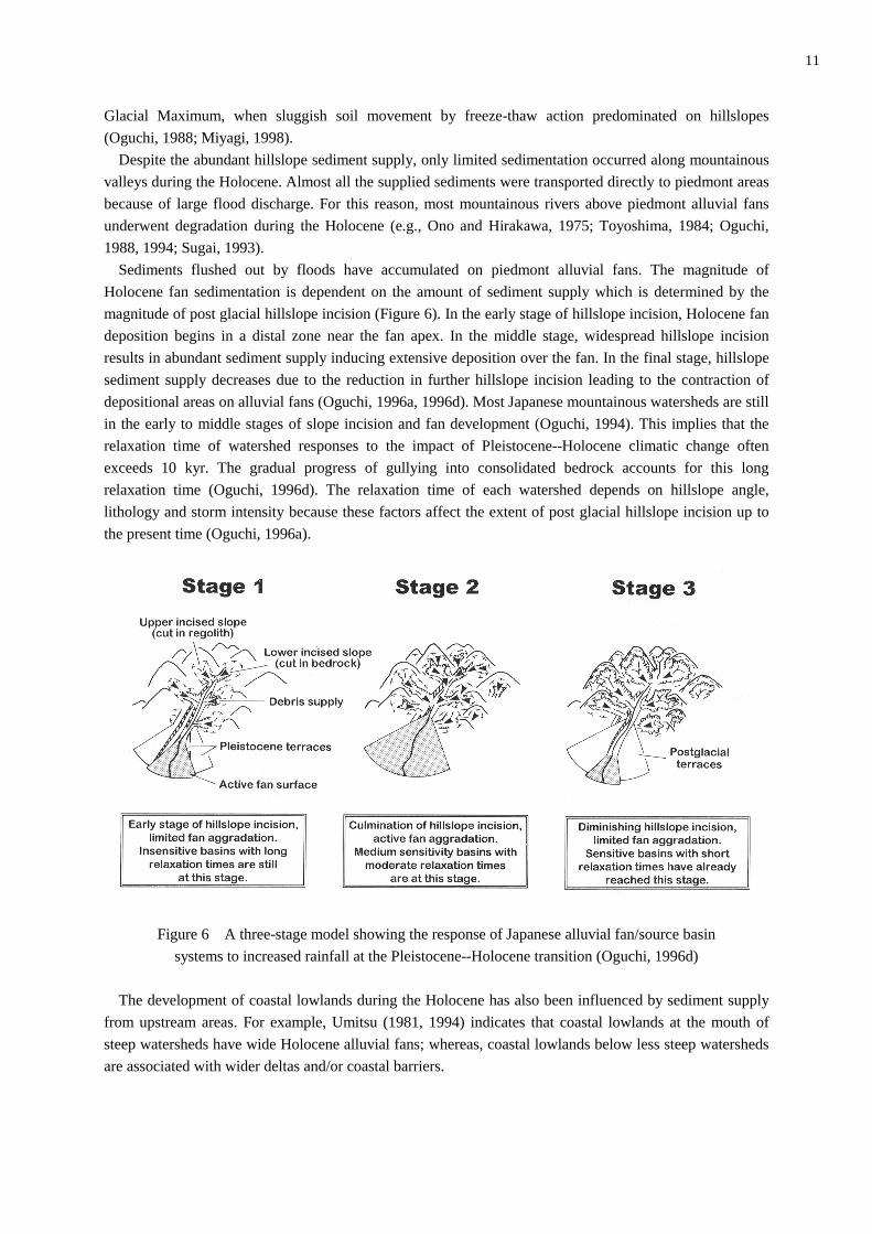
Sediments flushed out by floods have accumulated on piedmont alluvial fans. The magnitude of
Holocene fan sedimentation is dependent on the amount of sediment supply which is determined by the
magnitude of post glacial hillslope incision (Figure 6). In the early stage of hillslope incision, Holocene fan
deposition begins in a distal zone near the fan apex. In the middle stage, widespread hillslope incision
results in abundant sediment supply inducing extensive deposition over the fan. In the final stage, hillslope
sediment supply decreases due to the reduction in further hillslope incision leading to the contraction of
depositional areas on alluvial fans (Oguchi, 1996a, 1996d). Most Japanese mountainous watersheds are still
in the early to middle stages of slope incision and fan development (Oguchi, 1994). This implies that the
relaxation time of watershed responses to the impact of Pleistocene--Holocene climatic change often
exceeds 10 kyr. The gradual progress of gullying into consolidated bedrock accounts for this long
relaxation time (Oguchi, 1996d). The relaxation time of each watershed depends on hillslope angle,
lithology and storm intensity because these factors affect the extent of post glacial hillslope incision up to
the present time (Oguchi, 1996a).
Figure 6 A three-stage model showing the response of Japanese alluvial fan/source basin
systems to increased rainfall at the Pleistocene--Holocene transition (Oguchi, 1996d)
The development of coastal lowlands during the Holocene has also been influenced by sediment supply
from upstream areas. For example, Umitsu (1981, 1994) indicates that coastal lowlands at the mouth of
steep watersheds have wide Holocene alluvial fans; whereas, coastal lowlands below less steep watersheds
are associated with wider deltas and/or coastal barriers.
12
5. Paleohydrological reconstructions based on geomorphological and sedimentological evidence
In spite of the evident influence of past climatic change on landform development, only a limited number
of quantitative paleohydrological reconstructions using fluvial sediments and landforms have been
performed in Japan. This is mainly due to the past trend of geomorphological research in Japan.
Sedimentological approaches to fluvial landforms focused mainly on the age-determination and correlation
of geomorphic surfaces and their deposits, based mainly on tephrochronology and radiocarbon dating.
Gravel sizes of terrace deposits, however, have attracted some attention with regard to past changes in
hydrological conditions.
Ono and Hirakawa (1975) and Hirakawa (1977) investigated the gravel sizes of river-terrace deposits in
the Tokachi region, Hokkaido. Their work revealed that gravel deposited around the time of the Last
Glacial Maximum is markedly smaller than modern gravel. They attributed this difference to infrequent
storms in the Last Glacial age when few typhoons visited Japan. Similar differences between Last Glacial
and post glacial fluvial sediments have been inferred by Yoshinaga and Miyadera (1986) and Oguchi (1988,
1997b). Sugai (1993) examined river terrace deposits along the Usui River, central Japan, using the
relationship between tractive force and gravel sizes proposed by Baker (1974). His study confirmed that the
difference in gravel sizes between the Last Glacial Maximum and the present reflects the presence or
absence of typhoon visits to Japan. Kurashige (1996) re-examined Sugai's (1993) grain-size data to revise
the estimation of paleoflood magnitudes based on the selective entrainment concept (e.g., Komar, 1987;
Wilcock, 1992). Grossman (this volume) investigated gravel sizes for Holocene river terraces on the Ara
River in the Chichibu Basin near Tokyo. He inferred that differences in gravel sizes among the terrace
deposits reflect changes in flood magnitudes during the Holocene. Analyses of sedimentary facies in
Japanese coastal lowlands also suggest the effects of Holocene changes in river flow conditions (e.g.,
Daimaru, 1989; Endo et al., 1992). Detailed chronological analyses of these findings are expected to lead to
the reconstruction of the magnitude and timing of major changes in climatic and hydrologic regimes which
have taken place in the Japanese Islands in response to global climate change since the Pleistocene--
Holocene transition (K adomura, 1987).
Suzuki (1982) and Suzuki et al. (1983) discussed factors determining the rate of lateral planation by
Japanese rivers. He proposed a functional relationship among several factors affecting the rate of planation,
such as bedrock strength and the recurrence interval of large floods. He suggested that this relationship
would provide a new method for paleoflood reconstruction, if the relationship is applicable to various
regions and the precise age determination for the strath terraces is possible. The possibility of using this
method needs to be explored further in the future.
Saito (1998) applied a new geomorphological method to the reconstruction of Last Glacial precipitation
and temperature in Japan. Using the data for Japanese alluvial fans, he inferred a relationship between the
probability of alluvial fan occurrence and climatic conditions. He then used this relationship to estimate the
climate of Last Glacial based on the distribution of alluvial fans formed during the period. The results
indicate that the Last Glacial Maximum in Japan was characterized by a climate cooler and drier than the
present climate, which agrees with other paleoclimatic reconstructions. Saito used similar methods to
explain the distribution of alluvial fans in Taiwan and the Philippines in relation to climatic conditions
(Saito, 1995, 1997).
Although the majority of paleohydrological reconstructions in Japan depend on the gravel sizes and
facies of fluvial deposits, the methods used have limited accuracy (Wohl and Enzel, 1995). Therefore,
researchers in other countries have tended to use other methods which may result in more accurate
paleohydrological reconstructions. Especially, slackwater deposits along rivers have been used to estimate
the magnitudes and frequencies of paleofloods (e.g., Kochel and Baker, 1988). Such deposits have often

13
been investigated in arid to semi-arid regions including the American Southwest, Australia, and Spain (e.g.,
O'Conner et al., 1994; Wohl et al., 1994; Benito et al., 1998).
By contrast, it is commonly thought that bioturbation and pedogenesis limit the preservation of slack
water deposits in humid regions like Japan (e.g., Kochel et al., 1982; Baker, 1987). Indeed, slackwater
deposits have received little attention among Japanese geomorphologists. A recent study on the Nakagawa
River in central Japan, however, revealed the existence of well-preserved slackwater deposits in Japan
(Jones et al., this volume). These deposits were accumulated rapidly by frequent flooding during the last
five hundred years. Despite the potential for rapid bioturbation and pedogenesis under a humid climate,
their effects are not apparent in these deposits due to the very rapid and frequent sedimentation. This
indicates that paleoflood reconstruction using slackwater deposits can be carried out in humid regions with
frequent floods and large sediment discharges. Countries such as Japan and Taiwan are suitable for this
type of paleoflood research.
6. Final remarks
This paper has introduced fluvial geomorphological and paleohydrological research in Japan
emphasizing the geomorphologic and climatic characteristics of Japan that differ from those of continental
regions such as Europe and North America. Research on Japanese fluvial systems can contribute to the
understanding of the global variety of fluvial systems. In particular, the processes and their effects brought
about by the very rapid geomorphological changes in Japan due to the combination of steep landforms and
frequent storms, often accelerated by the effects of earthquakes and volcanic eruptions, offer opportunities
to carry out research projects which are unique to Japan’s environment.
Despite of the high probability of sediment disasters under natural conditions, about 120 million people
live in Japan. Thus, the government has spent a large amount of money to modify rivers to mitigate
sediment disasters, building many structures such as check dams and embankments. Although such
extensive modifications of rivers may not be favorable for investigating fluvial processes under pristine
natural conditions, they provide the possibility of doing interesting research in Japan on fluvial systems
under strong anthropogenic influences.
Currently, an increasing number of foreign geomorphologists are visiting Japan to carry out fluvial
geomorphological studies in collaboration with Japanese researchers. Such collaboration has already
resulted in some joint publications (e.g., Grossman et al., 1998; Kubo et al., 1998; Oguchi et al., 1998;
Wohl and Ikeda, 1998; Jones and Ui, 1999). It is hoped that this new trend will continue and will facilitate
the international understanding of fluvial geomorphology and paleohydrology in Japan.
References
Adams, J., 1980. Contemporary uplift and erosion of the Southern Alps, New Zealand. Bulletin of the
Geological Society of America 91 (Part 2), 1-114.
Ashida, K, Okumura, T., 1974. Study on sedimentation in reservoirs. Annals of Disaster Prevention Research
Institute, Kyoto University 17B, 555-570. (in Japanese with English abstract)
Baker, V.R., 1974. Paleohydraulic interpretation of Quaternary alluvium near Golden, Colorado. Quaternary
Research 4, 94-112.
Baker, V.R., 1987. Paleoflood hydrology and extraordinary flood events. Journal of Hydrology 96, 79-99.
Benito, G., Machado, M.J., Perez-Gonzalez, A., Sopena, A., 1998. Paleoflood hydrology of the Tagus River,
14
central Spain. In: Benito, G., Baker, V.R., Gregory, K.J. (Eds.), Palaeohydrology and Environmental Change.
John Wiley and Sons, Chichester. pp. 317-333.
Bull, W.B., 1977. The alluvial-fan environment. Progress in Physical Geography 1, 222-270.
Branson, J., Brown, A.G., and Gregory, K.J. (Eds.) Global Continental Changes: the Context of Palaeohydrology.
Geological Society Special Publication No.115, The Geological Society, London.
Chang, J., Shih, T., Yang, S., Lin, Y., Chen, H., 1994. A geomorphological study of alluvial fans in Huatung
Longitudinal Valley. Geographical Research (Taiwan) 21, 43-74. (in Chinese with English abstract)
Chang, J., Shih, T., Yang, S., Lin, Y., Chen, H., Tung, T., 1995. A geomorphological study of alluvial fans in
Lanyang area. Geographical Research (Taiwan) 23, 151-191. (in Chinese with English abstract)
Chorley, R.J., Schumm, S.A., Sugden, D.E., 1984. Geomorphology. Methuen, London. pp 605.
Costa, J.E., 1987. A comparison of the largest rainfall-runoff floods in the United States with those of the
People’s Republic of China and the world. Journal of Hydrology 96, 101-115.
Daimaru, H., 1989. Holocene evolution of the Toyohira River alluvial fan and distal floodplain, Hokkaido, Japan.
Geographical Review of Japan 62, 589-603. (in Japanese with English abstract)
Endo, K., Kanemaki, M., Nakai, N., Mori, I., Fujisawa, M., Koreeda, W., Kosugi, M., 1992. Geology of
Nakagawa Lowland and Misato City. In: History of Misato City (Nature), Misato City, 35-112. (in Japanese)
Gregory, K.J., Starkel, L. and Baker, V.R. (Eds.) 1995. Global Continental Palaeohydrology. John Wiley and
Sons, Chichester.
Grossman, M., this volume: Lange floods and climate change during the Holocene on the Ara River, Central
Japan. Geomorphology.
Grossman, M., Oguchi, T., Kadomura, H. (Eds.) 1998. Abstracts, Third International Meeting on Global
Continental Paleohydrology, Kumagaya, Japan. pp. 123
Hatano, S., 1979. Mapping of post glacial dissected hillslopes and its application to landslide prediction.
Abstracts, Japan Erosion-Control Engineering Society 1979, 16-17. (in Japanese)
Higaki, T., 1987. Chronology of mass movement and slope formation in the central Kitakami Mountains,
northeast Japan. The Quaternary Research (Tokyo) 26, 27-45. (in Japanese with English abstract)
Hirakawa, K., 1977. Chronology and evolution of landforms during the Late Quaternary in the Tokachi Plain
and adjacent areas, Hokkaido, Japan. Catena 4, 255-288.
Ikeda, Y., 1990. Erosion and uplift: observational basis for modeling mountain building processes. Journal of
Seismological Society of Japan 43, 137-152. (in Japanese with English abstract)
Inbar, M., 1992. Rates of fluvial erosion in basins with a Mediterranean climate type. Catena 19, 393-409.
Inoue, K., 1992. Downstream change in grain size of river bed sediments and its geomorphological implications
in the Kanto Plain, central Japan. Geographical Review of Japan 65B, 75-89.
Inoue, K., Oguchi, T., 1995. Effects of hillslope failure on the stream bifurcation ratio and stream length ratio for
the Matsumoto Region, Japan. Geographical Review of Japan 68A, 447-464. (in Japanese with English
abstract)
Ishihara, Y., Tomosugi, K., Kobatake, S., Shimojima, E., 1976. Prediction of rainfall characteristics and disaster.
In: Yano, K. (Ed.), Study on the storm disaster in August, 1975. Kyoto University. pp. 107-109. (in Japanese)
Iso, N., Yamakawa, K., Yonezawa, H., Matsubara, T., 1980. Accumulation rates of alluvial cones, constructed
by debris-flow deposits, in the drainage basin of the Takahara River, Gifu Prefecture, central Japan.
Geographical Review of Japan 53, 699-720. (in Japanese with English abstract)
Ito, K., 1983. Zenkoji Earthquake -- disaster of landslide and flood. Chiri, 28-4, 45-54. (in Japanese)
Iwai, S., Ishiguro, M., 1970. Applied statistics for hydrology. Morikita-Shuppan, Tokyo. pp 369. (in Japanese)
Jones, A.P., Ui, T., 1999. Pyroclastic and epiclastic deposits: a case study from the Unzen Volcano, Kyushu,
Japan. In: Jones, A.P., Tucker, M.E. and Hart, J.K. (Eds.), The description & analysis of Quaternary
stratigraphic field sections. Quaternary Research Association, Technical Guide No.7, London. pp. 137-170.
15
Jones, A.P., Shimazu, H., Oguchi, T., Okuno, M., Tokutake, M., this volume: Late Holocene slackwater deposits
on the Nakagawa River, Tochigi Prefecture, Japan. Geomorphology.
Kadomura, H., 1966. Ground-geology and natural disasters due to soft ground conditions of Shizuoka-Shimizu
Lowland, Central Japan. Journal of Geography (Tokyo), 75, 226-248, 282-283. (in Japanese with English
abstract)
Kadomura, H., 1968. Systematic aerial photo analysis of soft ground conditions. Geographical Review of Japan
41, 19-38. (in Japanese with English abstract)
Kadomura, H., 1971. Microgeomorphological features of alluvial fans and their formative processes. In Yazawa,
T., Toya, H., and Kaizuka, S. (Eds.), Alluvial fans--regional characteristics, Kokon-Shoin, 55-96. (in
Japanese)
Kadomura, H., 1987. Hydrogeomorphic implications of Early Holocene environmental changes --a review. In
Kadomura, H. (ed.), Hydrogeomorphological changes during the Early Holocene in cold regions, Report of
Grant-in-Aid for Scientific Research (B), Project No. 59460215, 1-29. (in Japanese)
Kadomura, H. and Chinen T., 1995. An environmental geomorphological contribution to prevent geomorphic
hazards caused by erosion and mass movements on active volcanoes in Japan-- case studies on Usu, Tokachi.
Unzen-Fugendake, and Sakurajima Volcanoes. Bulletin of Ryutsu-Keizai University 29 (4), 21-61.
Kadomura, H., Okada, Hm., Imagawa, T., Moriya, I., and Yamamoto, H., 1983b. Erosion and mass movements
on Mt. Usu accelerated by crustal deformation that accompanied its 1977-1982 volcanism. Natural Disaster
Science 5, 33-62.
Kadomura, H., Yamamoto, H. and Imagawa, T., 1983a. Eruption-induced rapid erosion and mass movements on
Usu Volcano, Hokkaido. Zeitschrift fur Geomorphologie Neue Folge Supplementary Band 46, 123-142.
Kaizuka, S., 1969. Changing landforms--under tectonic movement, sea level change, and climatic change.
Kagaku 39, 11-19. (in Japanese)
Kaizuka, S., 1987. Quaternary morphogenesis and tectogenesis of Japan. Zeitschrift fur Geomorphologie Neue
Folge Supplementary Band 63, 61-73.
Kaizuka, S., 1992. Understanding Fluvial Plains and Coastal Areas. Iwanami-Shoten, Tokyo, pp.142. (in
Japanese)
Katsube, K., Oguchi, T., 1999. Altitudinal changes in slope angle and profile curvature in the Japan Alps: A
hypothesis regarding a characteristic slope angle. Geographical Review of Japan 72B, 63-72.
Keller, E. A., Pinter, N., 1996. Active Tectonics -- Earthquales, Uplift and Landscapes. Prentice-Hall, Upper
Saddle River. pp. 338.
Kochel, R.C., Baker, V.R., 1988. Paleoflood analysis using slackwater deposits. In: Baker, V.R., Kochel, R.C.
and Patton, P.C. (Eds.), Flood Geomorphology. John Wiley and Sons, Chichester. pp. 498-513.
Kochel, R.C., Baker, V.R. and Patton, P.C., 1982. Paleohydrology of southwestern Texas. Water Resources
Research 18, 1165-1183.
Komar, P. D., 1987. Selective grain entrainment by a current from a bed of mixed sizes: a reanalysis. Journal of
Sedimentary Petrology 57, 203-211.
Kubo, S., Grossman, M., Shimazu, H. (eds.) 1998. The Ara River and the Chichibu Basin, Kanto District, Japan.
One-day Field Trip Guide, Third International Meeting on Global Continental Palaeohydrology
GLOCOPH'98. Rissho University, Kumagaya. pp. 28.
Kurashige, Y., 1996. Application of a hydrogeomorphological process study to geomorphology of larger time
scale --Application of selective entrainment equation to paleohydrological estimation--. Transactions,
Japanese Geomorphological Union 17, 275-283.
Langbein, W.B., Schumm, S.A., 1958. Yield of sediment in relation to mean annual precipitation. Transactions
of the American Geophysical Union 39, 1076-1084.
Leopold, L.B., Wolman, M.G., Miller, J.P., 1964. Fluvial processes in geomorphology. Freeman, San Francisco.
16
pp 522.
Li, Y.H., 1976. Denudation of Taiwan Island since the Pliocene Epoch. Geology 4, 105-107.
Machida, H., 1966. Rapid erosional development of mountain slopes and valleys caused by large landslides in
Japan. Geographical Reports of Tokyo Metropolitan University 1, 1-72.
Matsumoto, J., 1993. Global distribution of daily maximum precipitation. Bulletin of Department of Geography,
University of Tokyo 25, 43-48.
Michiue, M., Kojima, K., 1980. Prediction of slope failures due to heavy rains. Abstracts, 17th Symposium on
Natural Disaster Science, 131-134. (in Japanese)
Miller, A.J., Gupta, A. (Eds.), 1999. Varieties of Fluvial Form (Publication of International Association of
Geomorphologists, No. 7). John Wiley and Sons, Chichester.
Milliman, J.D. and Syvitski, P.M., 1992. Geomorphic/tectonic control of sediment discharge to the ocean: the
importance of small mountainous rivers. Journal of Geology 100, 525-544.
Miyagi, T. 1998. Late Quaternary environmental changes with special reference to the palaeohydrological
conditions and hillslope development in the Kawatomi Mini Basin, northern Japan. Abstracts, Third
International Meeting on Global Continental Paleohydrology, Kumagaya, Japan, 44.
Mizukoshi, M., 1965. The extreme values of daily precipitation in Japan (2nd report). Geographical Review of
Japan 38, 447-460. (in Japanese with English abstract)
Moriya, I., 1972. Classification and development of mountain slopes based on the morphology of landslide scars.
Abstracts of the Association of Japanese Geographers 2, 168-169. (in Japanese)
Moriya, I., 1985. Large landslide and debris flow on the south slope of Ontake Volcano, 1984. Gekkan-Chikyu,
7, 369-373. (in Japanese)
O'Conner, J.E., Ely, L.L., Wohl, E.E., Stenvens, L.E., Melis, T.S., Kale, V.S., Baker, V.R., 1994. A 4500-year
record of large floods on the Colorado River in the Grand Canyon, Arizona. Journal of Geology 102, 1-9.
Oguchi, T., 1988. Landform development during the Last Glacial and the Post-Glacial ages in the Matsumoto
Basin and its surrounding mountains, central Japan. The Quaternary Research (Tokyo) 27, 101-124. (in
Japanese with English abstract)
Oguchi, T., 1994. Late Quaternary geomorphic development of alluvial fan--source basin systems: the Yamagata
Region, Japan. Geographical Review of Japan 67B, 81-100.
Oguchi, T., 1996a. Factors affecting the magnitude of post-glacial hillslope incision in Japanese mountains.
Catena 26, 171-186.
Oguchi, T., 1996b. Hillslope failure and sediment yield in Japanese regions with different storm intensity.
Bulletin of the Department of Geography, University of Tokyo 28, 45-54.
Oguchi, T., 1996c. Late Quaternary hillslope erosion rates in Japanese mountains estimated from landform
classification and morphometry. Zeitschrift fur Geomorphologie Neue Folge Supplementary Band 106, 169-
181.
Oguchi, T., 1996d. Relaxation time of geomorphic responses to Pleistocene--Holocene climatic change.
Transactions, Japanese Geomorphological Union 17, 309-321.
Oguchi, T., 1997a. Drainage density and relative relief in humid steep mountains with frequent slope failure.
Earth Surface Processes and Landforms 22, 107-120.
Oguchi, T., 1997b. Late Quaternary sediment budget in alluvial-fan--source-basin systems in Japan. Journal of
Quaternary Science 12, 381-390.
Oguchi, T., Ohmori, H., 1994. Analysis of relationships among alluvial fan area, source basin area, basin slope,
and sediment yield. Zeitschrift fur Geomorphologie Neue Folge 38, 405-420.
Oguchi, T., Tanaka, Y., 1998. Occurrence of extrazonal periglacial landforms in the lowlands of Western Japan
and Korea. Permafrost and Periglacial Processes 9, 285-294.
Oguchi, T., Shimazu, H., Nakashinden, I., Grossman, M. (Eds.) 1998. Present-day Geomorphic Processes and
17
Paleohydrology in Central Japan: The Japan Alps and Vicinity. Post-Conference Field Trip Guide, Third
International Meeting on Global Continental Palaeohydrology GLOCOPH'98. Rissho University, Kumagaya.
pp. 78.
Ohmori, H., 1983. Characteristics of the erosion rate in the Japanese mountains from the viewpoint of climatic
geomorphology. Zeitschrift fur Geomorphologie Neue Folge Supplementary Band 46, 1-14.
Ohmori, H., 1991. Change in the mathematical function type describing the longitudinal profile of a river
through an evolutionary process. Journal of Geology 99, 97-110.
Ono, Y., 1990. Alluvial fans in Japan and South Korea. In: Rachocki, A.H. and Church, M. (Ed.), Alluvial fans:
a field approach. John Wiley & Sons, Chichester. pp. 91-107.
Ono, Y., Hirakawa, K., 1975. Glacial and periglacial morphogenetic environments around the Hidaka Range in
the Wurm Glacial age. Geographical Review of Japan 48, 1-26. (in Japanese with English abstract)
Ouchi, S., 1979. A study of minor reliefs and grain size distributions on alluvial fans in central Japan.
Geographical Review of Japan 52, 190-198. (in Japanese with English abstract)
Ouchi, S. and Mizuyama, T., 1989. Volume and movement of Tombi Landslide in 1858, Japan. Transactions,
Japanese Geomorphological Union 10, 27-51.
Oya, M., 1961. Geographical study of flood in the basin of the Mekong tributaries. Report of Reconnaissance
Team organized by the Japanese Government, Sept 1961.
Oya, M., 1973. Basic-form of the combination of the geomorphological elements in the alluvial plain. The
Scientific Researches, School of Education, Waseda University 22, 23-43. (in Japanese with English abstract)
Oya, M., Nakayama, M., Takagi, I., 1988. Studies on the geomorphological features of the fluvial plains in Japan
focusing the distribution, geomorphological land classification, and its application. Geographical Review of
Japan 61B, 35-49.
Oya, M., 1995. Geomorphological maps of alluvial plains and their utilization for mitigation of natural hazards:
flooding and soil liquefaction. Geographical Review of Japan 68B, 218-242.
Research Group for Active Faults of Japan, 1991. Active faults in Japan: sheet maps and inventories (Revised
Edition). University Tokyo Press, Tokyo. pp. 437. (in Japanese with English abstract)
Research Group for Quaternary Tectonic Map, 1968. Quaternary tectonic map of Japan. The Quaternary
Research (Tokyo), 7, 182-187. (in Japanese with English abstract)
Saito, K., 1984. Factors for the development of alluvial fans in Japan. Gakuen Ronsyu (Joural of Hokkai-Gakuen
University) 49, 15-42. (in Japanese with English abstract)
Saito, K., 1986. Geomorphic development of mountains and alluvial fans of Japan. Annals of Hokkaido
Geographical Society 60, 1-6. (in Japanese)
Saito, K., 1988. Alluvial fans in Japan. Alluvial fans in Japan. Kokon-Shoin, Tokyo. pp 280. (in Japanese)
Saito, K., 1990. Dominating factor for alluvial fan distribution in Japan and Taiwan. Journal of Hokkai-Gakuen
University 66, 1-22.
Saito, K., 1993. Effectiveness of a dynamic equilibrium model for alluvial fans in the Japanese Islands and
Taiwan Island. Journal of Saitama University, Faculty of Education (Humanities and Social Science) 42 (1),
33-48.
Saito, K., 1995. Influences of temperature and precipitation upon modern alluvial fans in Japan, Taiwan, and the
Philippines. Journal of Saitama University, Faculty of Education (Humanities and Social Science) 46(2), 1-10.
(in Japanese with English abstract)
Saito, K., 1997. Distribution and sizes of alluvial fans in Japan, Taiwan, and the Philippines. Occasional Paper of
Department of Geography, Saitama University 17, 1-12.
Saito, K., 1998. Climatic conditions in the later stadial of the Last Glacial based on alluvial fan distributions in
Japan. Abstracts, Third International Meeting on Global Continental Paleohydrology, Kumagaya, Japan, 75.
Saito, K., 1999. Development of mountains and alluvial fans in Japan, Taiwan, and the Philippines.
18
Geographical Review of Japan 72B, 162-172.
Shimazu, H., 1991. Downstream change in gravel size and bed form along tributaries and gravel supply for the
main stream in the Japanese Mountains. Geographical Review of Japan 64A, 569-580. (in Japanese with
English abstract)
Shimazu, H., 1994. Segmentation of Japanese mountain rivers and its causes based on gravel transport processes.
Transactions, Japanese Geomorphological Union 15, 111-128.
Shimazu, H., Oguchi, T., 1996. River processes after rapid valley-filling due to large landslides. GeoJournal 38,
339-344.
Starkel, L., Gregory, K.J. and Thornes, J.B. (Eds.) 1991. Temperate Palaeohydrology: Fluvial Processes in the
Temperate Zone During the Last 15,000 Years. John Wiley and Sons, Chichester.
Sugai, T., 1993. River terrace development by concurrent fluvial processes and climatic changes.
Geomorphology 6, 243-252.
Suzuki, H., 1971. Climatic zones of the Wurm Glacial Age. Bulletin of the Department of Geography,
University of Tokyo 3, 35-46.
Suzuki, T., 1982. Rate of Lateral Planation by Iwaki River, Japan. Transactions, Japanese Geomorphological
Union 3, 1-24.
Suzuki, T., Noda, H., Abe, Y., 1983. Rates of lateral planation by rivers in Japan. Transactions, Japanese
Geomorphological Union 4, 33-47.
Takahashi, Y., Sakaguchi, Y., 1976. Rivers in Japan. Kagaku 46, 488-499. (in Japanese)
Tanaka, S., 1977. General remarks on the relation of geologic and geomorphic structures with landslides. In:
Tanaka, S. (Ed.), Study on the relation of geologic and geomorphic structures with landslides. Kobe
University, Kobe. pp. 5-12. (in Japanese)
Tanaka, S., Inoue, S., Nomura, R., 1982. A study on the mechanism and chronology of colluvial slope formation
in the drainage basin of the Sugihara River, the southern part of Hyogo Prefecture. Geographical Review of
Japan 55, 525-548. (in Japanese with English abstract)
Toya, H., Machida, H., Naito, H., Hori, N., 1971. Distribution of alluvial fans in Japan. In: Yazawa, D., Toya, H.
and Kaizuka, S. (Eds.), Alluvial Fans. Kokon-Shoin, Tokyo, pp. 97-120. (in Japanese)
Toyoshima, M., 1984. The sequence of river terrace development in the last 20,000 years in the Ou Backbone
Range, northeastern Japan. Science Report of Tohoku University, Ser. 7 (Geography), 34, 88-105.
Tsukamoto, Y., 1973. Study on the growth of stream channel (1)--relationship between stream channel growth
and landslides occurring during heavy storm. Shin-sabo 87, 4-13. (in Japanese)
Umitsu, M., 1981. Geomorphic evolutions of the alluvial lowlands in Japan. Geographical Review of Japan 54,
142-160. (in Japanese with English abstract)
Umitsu, M., 1994. Late Quaternary Environment and Landform Evolution of Riverine Coastal Lowlands.
Kokon-Shoin, Tokyo. pp 270. (in Japanese)
Walling, D.E., 1996. Erosion and sediment yield in a changing environment. In: Branson, J., Brown, A.G. and
Gregory, K.J. (Eds.), Global Continental Changes: the Context of Palaeohydrology. Geological Society
Special Publication No.115, The Geological Society, London, pp. 43-56.
Wundt, W., 1953. Gewasserkunde. Springer-Verlag, Berlin/Gottingen/Heidelberg. pp 320.
Wilcock, P. R., 1992. Flow competence: a criticism of a classic concept. Earth Surface Processes and Landforms
17, 289-298.
Wohl, E.E., Enzel, Y., 1995. Data for palaeohydrology. In: Gregory, K.J., Starkel, L. and Baker, V.R. (Ed.),
Global Continental Palaeohydrology. John Wiley and Sons, Chichester. pp. 23-59.
Wohl, E.E., Ikeda, H., 1998. Patterns of bedrock channel erosion on the Boso Peninsula, Japan. Journal of
Geology 106, 331-345.
Wohl, E.E., Fuertsch, S.J., Baker, V.R., 1994. Sedimentary records of late Holocene floods along the Fitzroy and
19
Margaret Rivers, Western Australia. Australian Journal of Earth Sciences 41, 273-280.
Yanai, S., 1989. Age determination of hillslope with tephrochronological method in central Hokkaido, Japan.
Transactions, Japanese Geomorphological Union 10, 1-12. (in Japanese with English abstract)
Yatsu, E., 1955. On the longitudinal profile of the graded river. Transactions of the American Geophysical
Union 36, 211-663.
Yoshikawa, T., 1974. Denudation and tectonic movement in contemporary Japan. Bulletin of the Department of
Geography, University of Tokyo 6, 1-14.
Yoshikawa, T., Sugimura, A., Kaizuka, S., Ota, Y., Sakaguchi, Y., 1973. Geomorphology of Japan, the New
Edition. University of Tokyo Press, Tokyo. pp 415. (in Japanese)
Yoshikawa, T., Kaizuka, S., Ota, Y., 1981. The Landforms of Japan. University of Tokyo Press, Tokyo, pp 220.
Yoshinaga, S., Miyadera, M., 1986. Development of the lower terraces along the middle reach of the Ara River
in Kanto District, Japan. The Quaternary Research (Tokyo) 25, 187-201. (in Japanese with English abstract)