Embed Size (px)
Citation preview
425
Hungarian Geographical Bulletin 63 (4) (2014) 425–436. DOI: 10.15201/hungeobull.63.4.4
New opportunities for experiments in fl uvial geomorphology: the fl ume PTETHYS
Ervin PIRKHOFFER1, Ákos HALMAI1, Szabolcs CZIGÁNY1, Titusz BUGYA1, Andor RÁBAY1, Tamás BÖTKÖS1, Gábor NAGY1, Bettina BALASSA1,
Ildikó JANCSKÁRNÉ ANWEILER2 and Dénes LÓCZY1
Abstract
In recent decades both physical modelling and computer simulation of fl uvial processes has undergone rapid progress. The paper summarizes the achievements of both international and Hungarian laboratory experiments in fl uvial geomorphology. Then, the new auto-matically governed fl ume facility, called PTETHYS (Project for Tectonical and Hydrological Simulations) recently set up at the Faculty of Natural Sciences, University of Pécs, is pre-sented. Finally, some of the new opportunities it off ers for research in fl uvial geomorphology are briefl y demonstrated: the identifi cation of geomorphological thresholds; modelling the generation of (fl ash) fl oods and its application for the reconstruction of the architectural elements and geomorphic evolution of fl oodplains. Some important channel parameters can be quantitatively investigated: channel cross-section change, amount of bedload infl uencing braiding, current velocity distribution etc. The novelty of the facility is the easy adjustment of channel slope and continuous experimenting (no need for interruption as in the case of laser-scanned experiments). The scaling necessary for quantitative analyses is also tackled.
Keywords: physical modelling, fl ume, channel patt erns, fl ood generation, fl oodplain re-habilitation, scaling
Introduction
In recent decades monitoring has been launched in many instrumented catchments all over the world and numerous computer models have been elaborated for the explanation of some of the “eternal” questions of fl uvial geomorphology. At the same time, the weaknesses of the fi rst (a labour and 1 Institute of Geography, University of Pécs, H-7624 Pécs, Ifj úság útja 6. E-mail: pirkhoff @gamma.tt k.pte.hu2 Pollack Mihály Faculty of Engeneering and Information Technology, University of Pécs,
H-7624 Pécs, Boszorkány u. 2. E-mail: [email protected]
426
time-consuming activity involving high expenses) and the second approach (e.g. magnifi cation of errors springing from incorrect parametrisation or lim-ited applicability to real-life situations) have also been recognized.
Observing the scaling rules, the small-scale physical models, long es-tablished in water engineering, seem to be capable to bridge the gap between the two approaches. If the results of experimentations could be quantifi ed, physical modelling may also be helpful for the theoretical foundation of vari-ous water management tasks (including dam constructions, designing fl ood control alert and warning or river rehabilitation).
The aim of the project is to apply quantitative methods for the model-ling of braided (and in the future meandering) channel evolution. Hopefully, the results can be used in designing river restoration, too. The experiment also helps students to combine their knowledge in laboratory studies, experimental geomorphology and remote sensing.
Previous fl ume experiments
Reaching back to the end of the 19th century, physical modelling has a long tradition in water management. It is particularly frequently applied in river channel studies for diverse purposes. The largest hydraulic model ever built in the world replicates the Mississippi River and its major tributaries (the Ten-nessee, Arkansas and Missouri Rivers) in ca 170 hectares’ area near Clinton, Mississippi. Meant to aid fl ood control planning, it was built by 3,000 German and Italian prisoners of war for the US Army Corps of Engineers in 1944 (Fos-ter, J.E. 1971). (It still exists now but in a neglected condition.)
In the United States smaller-scale laboratory studies on river channels began by the US Army Corps of Engineers in Vicksburg, Mississippi, in 1929. The fi rst experiments, however, only modelled the origin of a meandering thalweg instead of a meandering channel (a famous example being Friedkin, J.F. 1945). A later recognition that patt ern changes occur rather abruptly in rivers in the course of a punctuated evolution and are driven by channel gra-dient and the mode of sediment transport (Leopold, L.B. and Wolman, M.G. 1957; Schumm, S.A. and Khan, H.R. 1972; Miall, A.D. 1996). These led to experiments where gradient and sediment supply were changed, while wa-ter discharge was kept constant, and parameters like channel width/depth ratio, mean current velocity, bedload discharge and concentration, shear and Froude number were recorded (Schumm, S.A. 1973). The morphodynamics, particularly the depositional activity of braided rivers have been intensively studied in experiments (e.g. Ashworth, P.J. et al. 1994).
In fl uvial geomorphology the second half of the 20th century was a period of identifi cation of important thresholds. Such are the critical channel
427
gradient values which separate straight, meandering and braided channel patt erns – a major issue in fl uvial geomorphology of the 1970s (Schumm, S.A. and Khan, H.R. 1972; Schumm, S.A. 1973; Brotherton, D.I. 1979).
The importance of bank strength was also recognised in determining channel patt ern (Kleinhans, M.G. 2010), rivers with stronger (oft en vegetated) banks being narrower and deeper, and alternate bars common in their chan-nel. Although it is widely accepted that bank-erosion rate and fl oodplain sedimentation, infl uenced by more complicated factors than just channel fl ow and sediment transport (Friedkin, J.F. 1945; Fraselle, Q. et al. 2010), are ex-tremely diffi cult to scale (Ashworth, P.J. et al. 2004), it is also noted that even small-scale experiments adequately reproduce spatial patt erns and the natural system dynamics (Paola, C. et al. 2009).
The importance of sediment transport was also recognised internation-ally (Ferguson, R.I. 1987) and in Hungary, too. In 1951 László Kádár began to set up a fl ume at the Kossuth Lajos University of Debrecen, Hungary, to study fl uvial geomorphological processes and drew att ention to the part sediment transport plays in the (trans)formation of channel patt erns. On the basis of the visual observations made in the fl ume, he published papers (Kádár, L. 1954, 1955, 1969), where he presented a geomorphologically more consistent picture of meandering than it was usual at the time when the “theory of types of river reaches”, borrowed from Germany, prevailed (Sipos, Gy. and Kiss, T. 2008).
In Hungarian water engineering model experiments started in 1928, when Sándor Rohringer installed a hydraulic laboratory of 670 m2 area at the Department of Water Construction, Budapest Technical University. The aim of the fi rst experiment was to investigate the hydraulics of the Danube channel at the artifi cial cut-off of Bogyiszló (Sárköz, South Hungary) (Fejér, L. 2001). In 1967 the Research Institute for Water Resources Management (VITUKI) established a hydrological model at the village Nick (Pannonhalmi, M. 2004). A fl ume of 40 × 6 m size supplemented with a glass channel 15 m long and 0.5 m wide was built to model a section of the Rába River. The experiments were conducted with the purpose of modelling meander shift s and the im-pacts of river regulation and served the basis for 48 river regulation proposals. However, the modelling of sediment transport was not satisfactory. Aft er 2007 the facility was not used.
The largest physical model in Hungary served the checking of the rehabilitation plans for the Danube fl oodplain in the Szigetköz aft er the con-struction of the Bős (Gabčíkovo) Barrage and diversion of the main chan-nel in 1992. The upper Szigetköz section of the Danube (from Dunakiliti to Dunaremete) was modelled at 1:500 scale, while the lower (from Dunaremete to Medve) at 1:700 scale in the Ecopark of Dunasziget. The impacts of river regulation are also reconstructed through the use of physical models (see e.g. Kornis-Akantisz, Zs. 1977).
428
Flume parameters
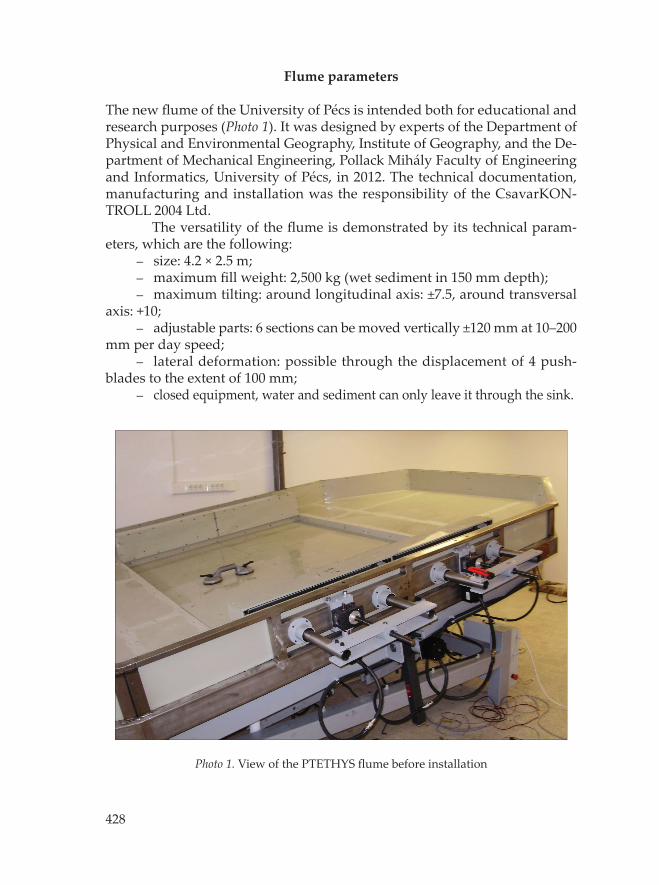
The new fl ume of the University of Pécs is intended both for educational and research purposes (Photo 1). It was designed by experts of the Department of Physical and Environmental Geography, Institute of Geography, and the De-partment of Mechanical Engineering, Pollack Mihály Faculty of Engineering and Informatics, University of Pécs, in 2012. The technical documentation, manufacturing and installation was the responsibility of the CsavarKON-TROLL 2004 Ltd.
The versatility of the fl ume is demonstrated by its technical param-eters, which are the following:
size: 4.2 × 2.5 m;maximum fi ll weight: 2,500 kg (wet sediment in 150 mm depth);maximum tilting: around longitudinal axis: ±7.5, around transversal
axis: +10;adjustable parts: 6 sections can be moved vertically ±120 mm at 10–200
mm per day speed;lateral deformation: possible through the displacement of 4 push-
blades to the extent of 100 mm; closed equipment, water and sediment can only leave it through the sink.
–––
–
–
–
Photo 1. View of the PTETHYS fl ume before installation
429
All motions in the fl ume are executed by computer-governed electro-engines. The speed of movements allows the modelling of both very slow and rather rapid changes. The rate of motions is checked by Leica Disto D3a BT laser meters (automatic feedback through Bluetooth).
Discharge is regulated through a 1-m-high water column, adjusted au-tomatically to the position of the table. Water is recycled by a pump system.
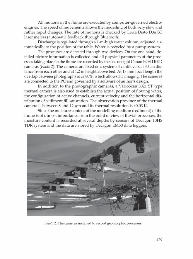
The processes are detected through two devices. On the one hand, de-tailed picture information is collected and all physical parameters of the proc-esses taking place in the fl ume are recorded by the use of eight Canon EOS 1100D cameras (Photo 2). The cameras are fi xed on a system of cantilevers at 30 cm dis-tance from each other and at 1.2 m height above bed. At 18 mm focal length the overlap between photographs is ca 80%, which allows 3D imaging. The cameras are connected to the PC and governed by a soft ware of author’s design.
In addition to the photographic cameras, a VarioScan 3021 ST type thermal camera is also used to establish the actual position of fl owing water, the confi guration of active channels, current velocity and the horizontal dis-tribution of sediment fi ll saturation. The observation province of the thermal camera is between 8 and 12 μm and its thermal resolution is ±0.03 K.
Since the moisture content of the modelling medium (sediment) of the fl ume is of utmost importance from the point of view of fl uvial processes, the moisture content is recorded at several depths by sensors of Decagon 10HS TDR system and the data are stored by Decagon EM50 data loggers.
Photo 2. The cameras installed to record geomorphic processes
430
The material used for the sediment fi ll is also carefully designed and manufactured particularly for this purpose. The colours of grains indicate grain size and density: coarse grains (1.0 and 0.8 mm diameter) are ground basalt and andesite of grey and black colour, while the 0.6 mm diameter grains are of red marble and those of 0.2 mm diameter are of beige limestone.
The functions of governing fl ume position on the one hand and imag-ing and data logging on the other are shared between diff erent computers. For imaging an Asus P9X79 PRO computer with Intel Core i7–3820 processor and nVidia GTX 660 Ti video card is applied. The operating system and processing is based on two Samsung 250 GB SATA3 2.5″ Basic (MZ–7TD250BW) SSDs, while data are stored by Seagate Barracuda 3 TB 64 MB 7,200 rpm SATA3 3.5″ (ST3000DM001) HDDs.
Image processing of stereo pairs and the representation of topography is performed by Agisoft StereoScan program. For the interpretation of the DEM and detection of processes ArcGIS 10.2.1 soft ware is available.
Possible applications
The objective of the fi rst experiment with the new fl ume was to fi nd out how reliably the development of channel patt erns can be modelled. The fl ume was fi lled with material of 8 cm depth and tilted at 5 degrees (~0.087). Imaging interval (both photographic and thermal) was set to 30 seconds.
Preliminary wett ing was applied to reach 40 percent of the saturation moisture content all over the experiment area. In order to trigger and accel-erate the process of channel incision a longitudinal groove of ca 2 cm depth was “burned” into the sediment surface. Previous observations showed that in lack of such an intervention, no collection of runoff into a channel would take place within an acceptable time span.
To identify active channel fl ow and current velocities, boiling water was conducted in pulses into the fl ume and its motion was detected by the thermal camera. The resulting channel cross-sections and sediment transport were studied in 3D images.
Braided channel evolution
Since Schumm, S.A. and Khan, H.R. (1972) found that channels above 0.016 gradient form a braided patt ern, it was expected that such patt ern will be the outcome from the fi rst experiment (Figure 1).
In the non-cohesive material increasing discharge led to gradu-ally broadening channels, providing space for more and more bifurcations

431
and the building of bars of various types. Thus, all the main morphological requirements for braiding were fulfi lled. Since the banks are easily erodible, channel width remarkably fl uctuates, but the width/depth ratio remains high throughout. During the experiment the following partial processes could be visually identifi ed:
channel widening through bank erosion;lateral bar accumulation;transverse bar accumulation and the resultant diversion of the thalweg;occasional reduction in the plan curvature of the thalweg, resulting
in channel widening;emergence of bifurcations and mid-channel bars at regular distance
from each other in broader channel sections;alternating cut and fi ll along the thalweg, which leads to a continuous
displacement of braids, a dynamic rearrangement of patt ern.The observed channel evolution corresponds to the observations by
Bertoldi, W. et al. (2001). The braided sections were locally replaced by anasto-mosing reaches, where the following partial processes were clearly visible:
with widening channel and lowering water level, some bars rise above the general surface as more stable “islands”;
the distributary channels bordering islands are very shallow just down-stream the bifurcation and only convey water at high water stages (“fl oods”);
––––
–
–
–
–
Fig. 1. The braided channel patt ern generated in the fi rst experiment
432
bifurcations are gradually replaced by avulsions (more perma-nent displacements of channel) where sediment accumulation is rapid, the distributary channels will acquire a slightly convex longitudinal profi le;
avulsions are concentrated where bank erosion is not particu-larly efficient since the banks are relatively stable but breach abruptly when reaching a threshold.
Comparing these observations with some descriptions of fi eld studies (e.g. Miller, J.R. 1991), remarkable re-semblances are seen. The development of avulsions is of great practical signifi cance as far as fl ood hazard is concerned.
Due to the tilting function of the fl ume, the adjustable channel gradient al-lows the experimental establishment of further thresholds, e.g. between meander-ing and braided river behaviour (Parker, G. 1976; Püspöki, Z. et al. 2005). Its sig-nifi cance is underlined by recent papers, where the challenge of physical modelling of meandering river behaviour is pointed out (van Dij k, W.M. et al. 2012).
Delta formation
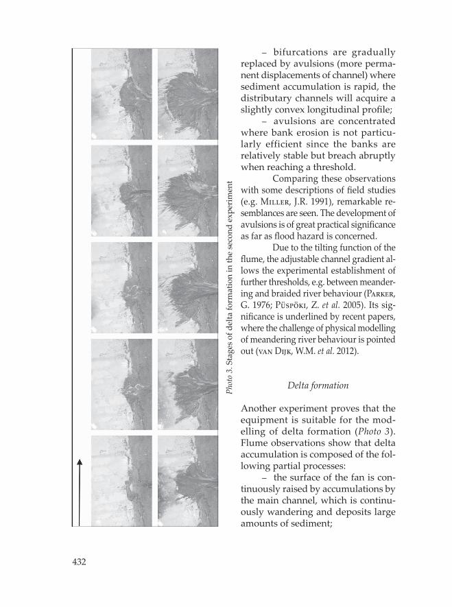
Another experiment proves that the equipment is suitable for the mod-elling of delta formation (Photo 3). Flume observations show that delta accumulation is composed of the fol-lowing partial processes:
the surface of the fan is con-tinuously raised by accumulations by the main channel, which is continu-ously wandering and deposits large amounts of sediment;
–
–
–
Phot
o 3.
Sta
ges of
delta
form
ation in
the second
exp
erim
ent
433
the main channel is aff ected by repeated avulsions and shift s to the lowest-lying zone of the delta fan;
if water discharge increases, vertical accretion also raises the level of inter-channel surfaces.
Similar channelisation, avulsion and backward sedimentation proc-esses on deltas of homogeneous material were found during experiments in the Netherlands (Van de Lageweg, W. 2013).
Flood modelling
In addition to in-channel geomorphic processes, overbank erosion and depo-sition can also be included among the objectives of physical modelling. This presupposes of creating an exact replica of the fl oodplain surface. The previ-ously applied GIS-based modelling of fl ood hazard (e.g. Czigány, Sz. et al. 2011) can be supplemented by fl ume experiments locating the potential sites of dyke breaches and avulsions as well as the predictable extent of fl oodplain inundation. If the boundary conditions leading to river fl ooding are exactly defi ned during the experiment, fi rst of all, local fl ood hazard (Lóczy, D. et al. 2009) can be precisely determined. The morphometric indices derived from the experiments are useful for estimating local fl ood hazard along channelized rivers and designing the necessary fl ood-control measures.
Floodplain rehabilitation planning
Through modelling channel migration and the related deposition processes, fl ume experiments are a potentially useful tool for reconstructing historical fl oodplain evolution under natural and human-induced conditions. Their advantages over fi eld data are the opportunity to set both initial and bound-ary conditions and the much faster operation of processes. With appropriate monitoring technology, morphological changes and the resultant architectural elements can be recorded without intervention into the processes.
Channel evolution observations may be the starting point for the re-construction of long-term fl oodplain evolution (Pizzuto, J.E. 1987; Bathurst, J.C. et al. 2002; Sellin, R.H.J. et al. 2003; Van Dij k, W.M. et al. 2013). In the fl ume the rate of sediment exchange between the main channel and distributaries can be measured and deposition patt erns on the fl oodplain demonstrated. From data on natural fl oodplain evolution and human-infl uenced processes in the fl oodplain, the measures necessary to create conditions under which the ecosystem functions of fl oodplains are optimally fulfi lled (i.e. fl oodplain rehabilitation) can be derived.
–
–
434
Similarity scaling
Until very recently physical models had been treated as analogue systems in com-parison to real-world fl uvial systems. Thus, the results of the experiments only al-lowed qualitative analyses of processes and the resultant landforms. Modern tech-nology developed for the documentation of experimentation outcomes (e.g. DEM representation of high spatial resolution and digital photography of high temporal resolution) makes measurements and quantitative assessment possible.
A major problem in the quantitative interpretation of the processes re-corded in fl ume experiments is seen in the spatial and temporal scaling. For scaling a set of rules have been established but not yet convincingly checked (Kleinhans, M.G. et al. 2010). The complexity of scaling to achieve similarity is addressed by numerous authors (see Paola, C. et al. 2009). Hydraulic scaling involves similar-ity in fl ow criticality (Froude number), current velocity, turbulence (Reynolds number), surface tension eff ects and bed roughness, while sediment-transport similarity refers to sediment mobility (Shields number), shear stress, particle size (Reynolds particle number) and suspended sediment (which is again the function of turbulence). We can also mention morphological similarity, i.e. the cumulative eff ect of width-to-depth ratio, channel bar dimensions and wavelength, transverse bed slope and other morphological parameters. Most of the above scaling factors have a temporal aspect, too, which also has to be considered.
A task of future research is to further develop the scaling rules in order to produce realistic and meaningful morphodynamics and stratigraphy (Van de Lageweg, W. 2013).
Acknowledgements: The project was partially fi nanced from TÁMOP/SROP-4.2.2.C-11/1/KONV-2012-0005 (Well-being in the Information Society) and by the Hungarian National Scientifi c Research Fund (OTKA, contract number K 104552).
REFERENCES
Ashworth, P.J., Best, J.L. and Jones, M. 2004. Relationship between sediment supply and avulsion frequency in braided rivers. Geology 32. 21–24.
Ashworth, P.J., Best, J.L., Leddy, J.O. and Geehan, G.W. 1994. The physical modelling of braided rivers and deposition of fi ne-grained sediment. In Process Models and Theoretical Geomorphology. Ed. Kirkby, M.J., Chichester, Wiley, Chichester. 115–139.
Bathurst, J.C., Benson I.A., Valentine, E.M. and Nalluri, C. 2002. Overbank sediment deposition patt erns for straight and meandering fl ume channels. Earth Surface Processes and Landforms 27. 659–665.
Bertoldi, W., Tubino, M. and Zolezzi, G. 2001. Laboratory measurements on channel bifurcations. Trento, University of Trento, Trento. 10 p. htt p://www.ing.unit.it/~bertoldiw_Laboratory_measurements_on_channel_bifurcations.pdf
435
Brotherton, D.I. 1979. On the origin and characteristics of river channel patt erns. Journal of Hydrology 44. 211–230.
Czigány, Sz., Pirkhoffer, E., Nagyváradi, L., Hegedűs, P. and Geresdi, I. 2011. Rapid screening of fl ash-fl ood-aff ected watersheds in Hungary. Zeitschrift für Geomorphologie 55. Supplementary Issue 1. 1–13.
Fejér, L. 2001. Vizeink krónikája (Chronicle of our waters). Budapest, Vízügyi Múzeum, Levéltára, Budapest. 307 p. (in Hungarian)
Ferguson, R.I. 1987. Hydraulic and sedimentary controls of channel patt ern. In River channels: environment and process. Ed. Richards, K.S. Oxford, Blackwell, Oxford. 125–158.
Forster, J.E. 1971. History and description of the Mississippi Basin Model. MRM Report 1–6. 115–126.
Fraselle, Q., Bousmar, D. and Zech, Y. 2010. Experimental investigation of sediment deposition on fl oodplains. In River Flow 2010. Eds. Dittrich, A., Koll, Ka., Aberle, J. and Geisenhainer, P. 8–10 September 2010, Braunschweig, Germany. Bundesanstalt für Wasserbau, Karlsruhe,. 823–830.
Friedkin, J.F. 1945. A laboratory study of meandering of alluvial streams. Vicksburg, MS., US Army Corps of Engineers Waterways Experiment Station, 40 p.
Kádár, L. 1954. Az eróziós folyamatok dialektikája (Dialectics of erosion processes). Közlemények a Debreceni Kossuth Lajos Tudományegyetem Földrajzi Intézetéből (Papers of the Institute of Geography, Kossuth Lajos University of Debrecen) 18. 1–20. (in Hungarian)
Kádár, L. 1955. Das Problems des Flussmäander. Közlemények a Debreceni Kossuth Lajos Tudományegyetem Földrajzi Intézetéből (Papers of the Institute of Geography, Kossuth Lajos University of Debrecen) 21. 1–24.
Kádár, L. 1969. Specifi c types of fl uvial landforms related to the diff erent manners of load-transport. Acta Geographica Debrecina 8–9. 115–178.
Kleinhans, M.G. 2010. Sorting out river channel patt erns. Progress in Physical Geography 34. 287–326.
Kleinhans, M.G., Van Dij k, W.M., Van de Lageweg, W.I., Hoendervoogt, R., Markies, H. and Schuurman, F. 2010. From nature to lab: scaling self-formed meandering and braided rivers. In River Flow 2010. Eds. Dittrich, A., Koll, Ka., Aberle, J. and Geisenhainer, P. 8–10 September 2010, Braunschweig. Vol. 2. Karlsruhe, Bundesanstalt für Wasserbau, Karlsruhe. 1001–1010.
Kornis A.-né Akantisz, Zs. 1977. Mozgó medrű folyószabályozási kisminta-kísérletek (Model experiments for river regulation with moveable bed). Hidrológiai Közlöny 12. 546–553. (in Hungarian)
Leopold, L.B. and Wolman, M.G. 1957. River channel patt erns: braided, meandering, and straight. US Geological Survey Professional Paper 282-B. Washington, D.C.
Lóczy, D., Kis, É. and Schweitzer, F. 2009. Local fl ood hazards assessed from channel morphometry along the Tisza River in Hungary. Geomorphology 113. 200–209.
Miall, A.D. 1996. The geology of fl uvial deposits: sedimentary facies, basin analysis, and petroleum geology. New York, Springer, 582 p.
Miller, J.R. 1991. Development of anastomosing channels in south-central Indiana. Geomorphology 4. 221-229
Pannonhalmi, M. 2004. A nicki kisminta kísérleti telep története, jelenlegi állapota. (History and presend-day state of the hydraulic model at Nick). Presentation at the Annual Meeting of the Hungarian Hydrological Society, Győr, 18 May 2004. (in Hungarian)
436
Paola, C., Straub, K.M., Mohrig, D.C. and Reinhardt, L. 2009. The “unreasonable eff ectiveness” of stratigraphic and geomorphic experiments. Earth-Science Reviews 97. 1–43.
Parker, G. 1976. On the cause and characteristic scales of meandering and braiding in rivers. Journal of Fluid Mechanics 76. (3): 457–480.
Pizzuto, J.E. 1987. Sediment diff usion during overbank fl ows. Sedimentology 34. 301–317.
Püspöki, Z., Szabó, Sz., Demeter, G., Szalai, K., McIntosh, R.W., Vincze, I., Németh, G. and Kovács, I. 2005. The statistical relationship between unconfi ned com-pressive strengths and the frequency distributions of slope gradients: A case study in northern Hungary. Geomorphology 71. (3–4): 424–436.
Schumm, S.A. 1973. Geomorphic threshold and complex response of drainage sys-tems. In: Fluvial geomorphology. Ed. Morisawa, M. Binghampton Publications in Geomorphology 3. 299–310.
Schumm, S.A. and Khan, H.R. 1972. Experimental study of channel patt erns. Geological Society of America Bulletin 83. 1755–1770.
Sellin, R.H.J., Bryant, T.B. and Loveless, J.H. 2003. An improved method for rough-ening fl oodplains on physical river models. Journal of Hydraulic Research 41. (1): 3–14.
Sipos, Gy. and Kiss, T. 2008. A medermintázatok értelmezése Kádár László kutatá-sainak fényében (Explanations of channel patt erns in the light of László Kádár’s investigations). In Geographia generalis et specialis. Eds. Szabó, J. and Demeter, G. Debrecen, Kossuth Egyetemi Kiadó. 49–54. (in Hungarian)
SZITE 2007. Javaslat a Szigetköz–Csallóközi hullámtéri mellékágrendszer többcélú rehabilitációjára (Proposal for the multi-purpose rehabilitation of the Szigetköz–Csallóköz by-channel system in the active fl oodplain). Szigetközi Természetvédelmi Egyesület (Szigetköz Association for Nature Conservation), 28 p. (in Hungarian) htt p://www.szite.hu/hun/duna_rehabilitacio.html
van de Lageweg, W. 2013. Morphodynamics and sedimentary architecture of meandering riv-ers. PhD Thesis. Utrecht, Utrecht University, Faculty of Geosciences, Department of Physical Geography, Utrecht. 159 p. htt p://about.me/wietsevandelageweg
van Dij k, W.M., van de Lageweg, W.I. and Kleinhans, M.G. 2012. Experimental me-andering river with chute cutoff s. Journal of Geophysical Research 117. F03023, doi:10.1029/2011JF002314.
van Dij k, W.M., van de Lageweg, W. and Kleinhans, M.G. 2013. Formation of a cohesive fl oodplain in a dynamic experimental meandering river. Earth Surface Processes and Landforms 38. (13): 1550–1565.