Embed Size (px)
Citation preview
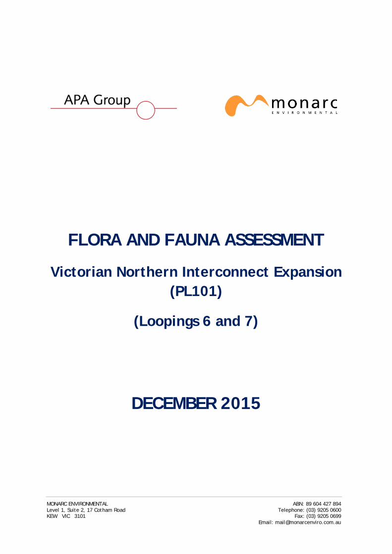
FLORA AND FAUNA ASSESSMENT
Victorian Northern Interconnect Expansion (PL101)
(Loopings 6 and 7)
DECEMBER 2015
MONARC ENVIRONMENTAL ABN: 89 604 427 894 Level 1, Suite 2, 17 Cotham Road Telephone: (03) 9205 0600 KEW VIC 3101 Fax: (03) 9205 0699
Email: [email protected]
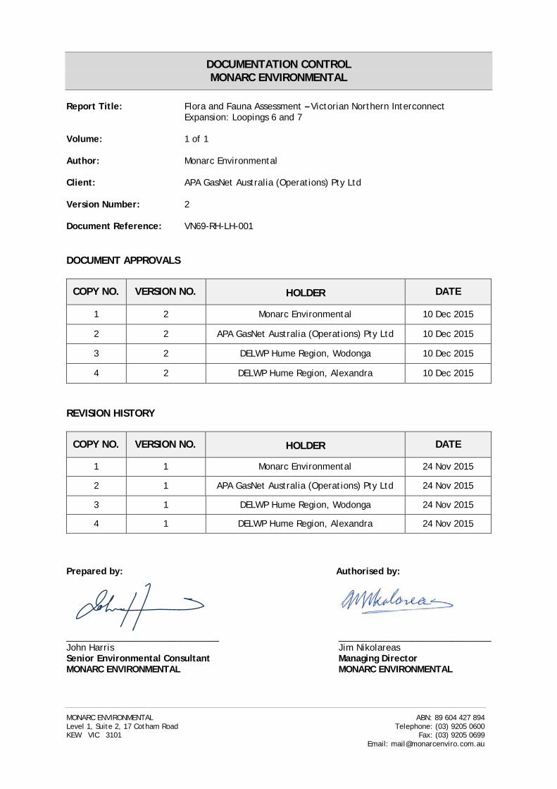
DOCUMENTATION CONTROL MONARC ENVIRONMENTAL
Report Title: Flora and Fauna Assessment – Victorian Northern Interconnect
Expansion: Loopings 6 and 7 Volume: 1 of 1 Author: Monarc Environmental Client: APA GasNet Australia (Operations) Pty Ltd Version Number: 2 Document Reference: VN69-RH-LH-001 DOCUMENT APPROVALS
COPY NO. VERSION NO. HOLDER DATE
1 2 Monarc Environmental 10 Dec 2015
2 2 APA GasNet Australia (Operations) Pty Ltd 10 Dec 2015
3 2 DELWP Hume Region, Wodonga 10 Dec 2015
4 2 DELWP Hume Region, Alexandra 10 Dec 2015
REVISION HISTORY
COPY NO. VERSION NO. HOLDER DATE
1 1 Monarc Environmental 24 Nov 2015
2 1 APA GasNet Australia (Operations) Pty Ltd 24 Nov 2015
3 1 DELWP Hume Region, Wodonga 24 Nov 2015
4 1 DELWP Hume Region, Alexandra 24 Nov 2015
Prepared by: Authorised by: _______________________________ _______________________________ John Harris Jim Nikolareas Senior Environmental Consultant Managing Director MONARC ENVIRONMENTAL MONARC ENVIRONMENTAL
MONARC ENVIRONMENTAL ABN: 89 604 427 894 Level 1, Suite 2, 17 Cotham Road Telephone: (03) 9205 0600 KEW VIC 3101 Fax: (03) 9205 0699
Email: [email protected]
APA GasNet Australia (Operations) Pty Ltd Victorian Northern Interconnect Expansion - Flora and Fauna Assessment PART A Loopings 6 & 7
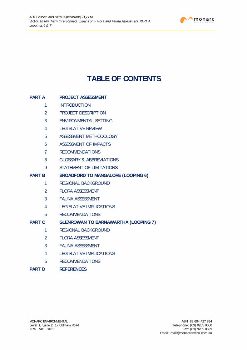
TABLE OF CONTENTS
PART A PROJECT ASSESSMENT
1 INTRODUCTION
2 PROJECT DESCRIPTION
3 ENVIRONMENTAL SETTING
4 LEGISLATIVE REVIEW
5 ASSESSMENT METHODOLOGY
6 ASSESSMENT OF IMPACTS
7 RECOMMENDATIONS
8 GLOSSARY & ABBREVIATIONS
9 STATEMENT OF LIMITATIONS
PART B BROADFORD TO MANGALORE (LOOPING 6)
1 REGIONAL BACKGROUND
2 FLORA ASSESSMENT
3 FAUNA ASSESSMENT
4 LEGISLATIVE IMPLICATIONS
5 RECOMMENDATIONS
PART C GLENROWAN TO BARNAWARTHA (LOOPING 7)
1 REGIONAL BACKGROUND
2 FLORA ASSESSMENT
3 FAUNA ASSESSMENT
4 LEGISLATIVE IMPLICATIONS
5 RECOMMENDATIONS
PART D REFERENCES
MONARC ENVIRONMENTAL ABN: 89 604 427 894 Level 1, Suite 2, 17 Cotham Road Telephone: (03) 9205 0600 KEW VIC 3101 Fax: (03) 9205 0699
Email: [email protected]
APA GasNet Australia (Operations) Pty Ltd Victorian Northern Interconnect Expansion - Flora and Fauna Assessment PART A Loopings 6 & 7
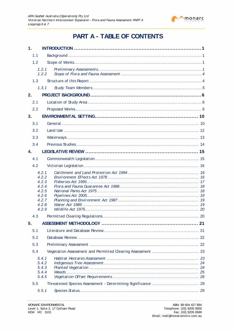
PART A - TABLE OF CONTENTS
1. INTRODUCTION ............................................................................... 1
1.1 Background .............................................................................................. 1
1.2 Scope of Works .......................................................................................... 1
1.2.1 Preliminary Assessments ......................................................................... 1 1.2.2 Scope of Flora and Fauna Assessment ......................................................... 4
1.3 Structure of this Report ............................................................................... 4
1.3.1 Study Team Members ............................................................................. 5
2. PROJECT BACKGROUND ..................................................................... 6
2.1 Location of Study Area ................................................................................ 6
2.2 Proposed Works ......................................................................................... 6
3. ENVIRONMENTAL SETTING ................................................................ 10
3.1 General ................................................................................................. 10
3.2 Land Use ............................................................................................... 12
3.3 Waterways ............................................................................................. 13
3.4 Previous Studies ...................................................................................... 14
4. LEGISLATIVE REVIEW ...................................................................... 15
4.1 Commonwealth Legislation ......................................................................... 15
4.2 Victorian Legislation ................................................................................. 16
4.2.1 Catchment and Land Protection Act 1994 .................................................. 16 4.2.2 Environment Effects Act 1978 ................................................................ 16 4.2.3 Fisheries Act 1995 ............................................................................... 17 4.2.4 Flora and Fauna Guarantee Act 1988 ........................................................ 18 4.2.5 National Parks Act 1975 ........................................................................ 18 4.2.6 Pipelines Act 2005 ............................................................................... 19 4.2.7 Planning and Environment Act 1987 ......................................................... 19 4.2.8 Water Act 1989 .................................................................................. 19 4.2.9 Wildlife Act 1975 ................................................................................ 20
4.3 Permitted Clearing Regulations .................................................................... 20
5. ASSESSMENT METHODOLOGY ............................................................ 21
5.1 Literature and Database Review ................................................................... 21
5.2 Database Review ..................................................................................... 22
5.3 Preliminary Assessment ............................................................................. 22
5.4 Vegetation Assessment and Permitted Clearing Assessment ................................. 23
5.4.1 Habitat Hectares Assessment ................................................................. 23 5.4.2 Indigenous Tree Assessment ................................................................... 24 5.4.3 Planted Vegetation ............................................................................. 24 5.4.4 Weeds ............................................................................................. 25 5.4.5 Vegetation Offset Requirements ............................................................. 26
5.5 Threatened Species Assessment - Determining Significance ................................. 29
5.5.1 Species Status .................................................................................... 29
MONARC ENVIRONMENTAL ABN: 89 604 427 894 Level 1, Suite 2, 17 Cotham Road Telephone: (03) 9205 0600 KEW VIC 3101 Fax: (03) 9205 0699
Email: [email protected]
APA GasNet Australia (Operations) Pty Ltd Victorian Northern Interconnect Expansion - Flora and Fauna Assessment PART A Loopings 6 & 7
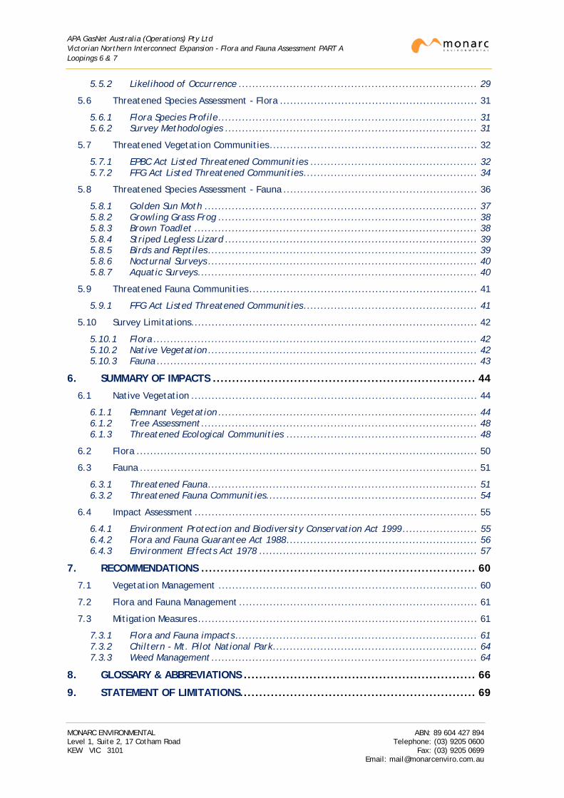
5.5.2 Likelihood of Occurrence ...................................................................... 29
5.6 Threatened Species Assessment - Flora .......................................................... 31
5.6.1 Flora Species Profile ............................................................................ 31 5.6.2 Survey Methodologies .......................................................................... 31
5.7 Threatened Vegetation Communities ............................................................. 32
5.7.1 EPBC Act Listed Threatened Communities ................................................. 32 5.7.2 FFG Act Listed Threatened Communities ................................................... 34
5.8 Threatened Species Assessment - Fauna ......................................................... 36
5.8.1 Golden Sun Moth ................................................................................ 37 5.8.2 Growling Grass Frog ............................................................................ 38 5.8.3 Brown Toadlet ................................................................................... 38 5.8.4 Striped Legless Lizard .......................................................................... 39 5.8.5 Birds and Reptiles ............................................................................... 39 5.8.6 Nocturnal Surveys ............................................................................... 40 5.8.7 Aquatic Surveys .................................................................................. 40
5.9 Threatened Fauna Communities ................................................................... 41
5.9.1 FFG Act Listed Threatened Communities ................................................... 41
5.10 Survey Limitations .................................................................................... 42
5.10.1 Flora ............................................................................................... 42 5.10.2 Native Vegetation ............................................................................... 42 5.10.3 Fauna .............................................................................................. 43
6. SUMMARY OF IMPACTS .................................................................... 44
6.1 Native Vegetation .................................................................................... 44
6.1.1 Remnant Vegetation ............................................................................ 44 6.1.2 Tree Assessment ................................................................................. 48 6.1.3 Threatened Ecological Communities ........................................................ 48
6.2 Flora .................................................................................................... 50
6.3 Fauna ................................................................................................... 51
6.3.1 Threatened Fauna ............................................................................... 51 6.3.2 Threatened Fauna Communities .............................................................. 54
6.4 Impact Assessment ................................................................................... 55
6.4.1 Environment Protection and Biodiversity Conservation Act 1999 ...................... 55 6.4.2 Flora and Fauna Guarantee Act 1988 ........................................................ 56 6.4.3 Environment Effects Act 1978 ................................................................ 57
7. RECOMMENDATIONS ....................................................................... 60
7.1 Vegetation Management ............................................................................ 60
7.2 Flora and Fauna Management ...................................................................... 61
7.3 Mitigation Measures .................................................................................. 61
7.3.1 Flora and Fauna impacts ....................................................................... 61 7.3.2 Chiltern - Mt. Pilot National Park ............................................................ 64 7.3.3 Weed Management .............................................................................. 64
8. GLOSSARY & ABBREVIATIONS ............................................................ 66
9. STATEMENT OF LIMITATIONS ............................................................. 69
MONARC ENVIRONMENTAL ABN: 89 604 427 894 Level 1, Suite 2, 17 Cotham Road Telephone: (03) 9205 0600 KEW VIC 3101 Fax: (03) 9205 0699
Email: [email protected]
APA GasNet Australia (Operations) Pty Ltd Victorian Northern Interconnect Expansion - Flora and Fauna Assessment PART A Loopings 6 & 7
ANNEXURES List of Tables
Table 1: Summary of Assessment Team ........................................................................... 5
Table 2: Summary of Declared Noxious Weeds occurring in both Loopings ............................... 26
Table 3: Characteristics that Determine Species Significance .............................................. 29
Table 4: The Likelihood of Occurrence Criteria for Threatened Flora Species ........................... 30
Table 5: The Likelihood of Occurrence Criteria for Threatened Fauna Species .......................... 30
Table 6: Summary of Habitat Hectare Assessments to be Offset (looping 6) ............................. 44
Table 7: Summary of Habitat Hectare Assessment to be Offset (looping 7) .............................. 45
Table 8: Summary of Habitat Hectare Assessments exempt from Offset (looping 6) ................... 45
Table 9: Summary of Habitat Hectare Assessments exempt from Offset (looping 7) ................... 46
Table 10: Summary of EVCs Recorded per Looping, Total Area and Status ............................... 47
Table 11: Summary of Scattered Indigenous Trees to be Impacted per Looping ......................... 48
Table 12: Summary of Threatened Ecological Communities found within construction ROW ......... 49
Table 13: Summary of Threatened Flora Survey records ..................................................... 50
Table 14: Summary of Locations where Threatened Flora were recorded ................................ 51
Table 15: Summary of Threatened Fauna Survey records .................................................... 52
Table 16: Summary of Locations where Threatened Fauna were recorded ............................... 53
Table 17: Summary of Threatened Fauna Communities Occurring within the Construction ROW .... 54
Table 18: Summary of Biodiversity related EES Triggers ..................................................... 58
List of Figures
Figure 1: Overview of Proposed Looping 6 ........................................................................ 2
Figure 2: Overview of Proposed Looping 7 ........................................................................ 3
Figure 3: Typical layout of construction ROW .................................................................... 8
Figure 4: HDD Schematic Drawing .................................................................................. 9
MONARC ENVIRONMENTAL ABN: 89 604 427 894 Level 1, Suite 2, 17 Cotham Road Telephone: (03) 9205 0600 KEW VIC 3101 Fax: (03) 9205 0699
Email: [email protected]
APA GasNet Australia (Operations) Pty Ltd Victorian Northern Interconnect Expansion - Flora and Fauna Assessment PART A Loopings 6 & 7
1. INTRODUCTION
1.1 Background
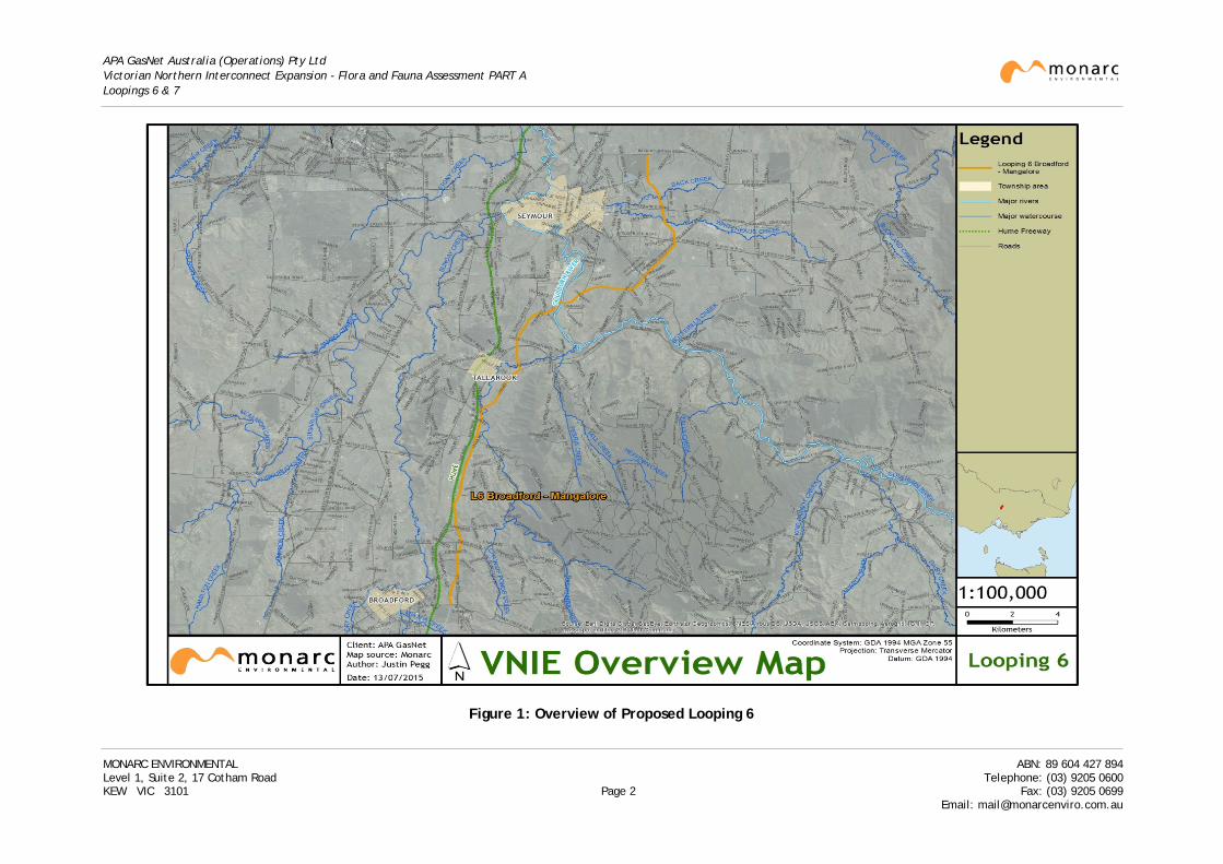
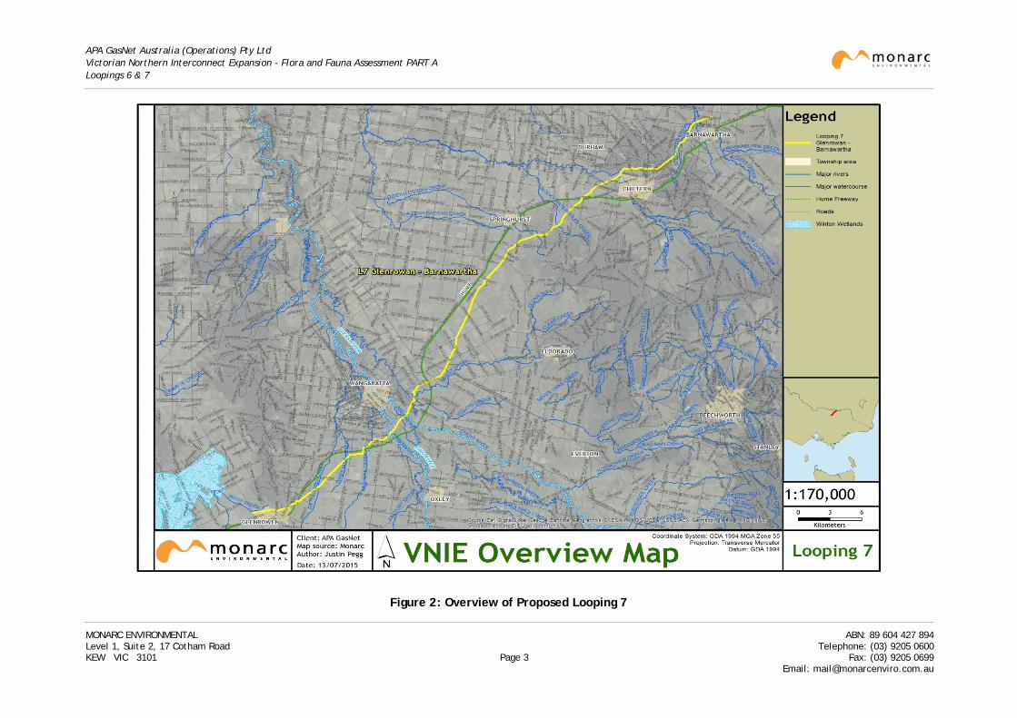
APA GasNet Australia (Operations) Pty Ltd (APA) are proposing to loop (duplicate) sections of the existing 300mm Wollert to Wodonga gas transmission pipeline (pipeline licence PL101) between Broadford to Mangalore and Glenrowan to Barnawartha, Victoria.
The sections of the route being looped consist of the following:
• Looping 6: Broadford to Mangalore (KP45.2 to KP74.3) covering about 29.1km.
• Looping 7: Glenrowan to Barnawartha (KP118.2 to KP184.6) covering about 66.4km.
An overview of the routes is provided in Figure 1 and Figure 2 respectively. Note that:
• The naming conventions used in this report take into consideration that APA has completed looping a number of other sections of the pipeline between Wollert and Glenrowan. These were separate projects and flora and fauna issues for these sections have been addressed in previous reports assessed and approved by the Department of Environment, Land, Water and Planning (DELWP).
• For Looping 6, KP0.0 commences 500m south of Summerhill Road, Wollert within the Wollert Compressor Station.
• For Looping 7, KP0.0 has been set at 100m south of Back Mountain Road, Seymour (commencement of Looping 3).
Monarc Environmental (Monarc) has been engaged by APA to undertake a flora and fauna assessment of the potential construction area for Looping 6 and 7 (defined as the construction Right-of-Way (ROW)). The purpose of the assessment was to identify any risks to significant flora and fauna values within the construction ROW and provide the necessary information to enable management recommendations for flora and fauna affected by the proposed project.
1.2 Scope of Works
1.2.1 Preliminary Assessments
A preliminary walk through field survey of the existing pipeline easement within Loopings 6 and 7 was undertaken in order to:
• Determine native vegetation cover and general ecological status of the area.
• Identify areas of remnant vegetation and scattered trees within the construction ROW that would require a Habitat Hectares assessment under the Native Vegetation Permitted Clearing Regulations should they require removal.
• Identify key ecological values and habitats within the construction ROW and potential impacts of proposed construction activities.
• Identify potential field surveys targeting those threatened flora and fauna species that may potentially be found along or near the construction ROW within habitat types identified during the preliminary survey.
These surveys have formed the basis of the assessments documented in this report.
MONARC ENVIRONMENTAL ABN: 89 604 427 894 Level 1, Suite 2, 17 Cotham Road Telephone: (03) 9205 0600 KEW VIC 3101 Page 1 Fax: (03) 9205 0699
Email: [email protected]
APA GasNet Australia (Operations) Pty Ltd Victorian Northern Interconnect Expansion - Flora and Fauna Assessment PART A Loopings 6 & 7
Figure 1: Overview of Proposed Looping 6
MONARC ENVIRONMENTAL ABN: 89 604 427 894 Level 1, Suite 2, 17 Cotham Road Telephone: (03) 9205 0600 KEW VIC 3101 Page 2 Fax: (03) 9205 0699 Email: [email protected]
APA GasNet Australia (Operations) Pty Ltd Victorian Northern Interconnect Expansion - Flora and Fauna Assessment PART A Loopings 6 & 7
Figure 2: Overview of Proposed Looping 7
MONARC ENVIRONMENTAL ABN: 89 604 427 894 Level 1, Suite 2, 17 Cotham Road Telephone: (03) 9205 0600 KEW VIC 3101 Page 3 Fax: (03) 9205 0699 Email: [email protected]
APA GasNet Australia (Operations) Pty Ltd Victorian Northern Interconnect Expansion - Flora and Fauna Assessment PART A Loopings 6 & 7
1.2.2 Scope of Flora and Fauna Assessment
The following tasks were undertaken by Monarc for the project area:
• Review of publicly available information relevant to an evaluation of flora and fauna issues including:
o Planning Zones, Land Use, Overlays and topographic features along the proposed route.
o Public databases such as those maintained by the Commonwealth Department of the Environment (DoE) and DELWP (formerly the Department of Environment and Primary Industries - DEPI) to determine potential significant flora and fauna and vegetation communities in the area.
o Public reports relating to environmental studies of the area.
o Discussion with local council officers or other relevant authorities to determine potential environmental sensitivities of the area such as significant species or land parcels.
o Results of the preliminary walk through field surveys.
• A Habitat Hectare Assessment of the project area in accordance with the Vegetation Quality Assessment manual (DSE 2004a).
• Targeted surveys for those threatened flora and fauna species that may potentially be found along or near the proposed construction ROW within habitat types identified during the preliminary survey and habitat hectares assessment.
• Preparation of a report to document the findings of surveys which includes:
o Targeted flora and fauna survey results including conservation significance of extant species.
o Vegetation assessment results including extent, type and condition of native vegetation.
o A Habitat Hectares Assessment of native vegetation proposed for removal.
o Potential impacts of proposed works on ecological values.
o Options to avoid and/or mitigate any impacts.
o Implications for the project arising from Commonwealth and State legislation and policy including whether an EPBC referral and EES statement are required.
Note that planted vegetation, unless it falls under the permitted clearing regulations, does not form part of the native vegetation assessment. Exotic vegetation and other planted areas such as windbreaks have therefore not been mapped as part of this project.
1.3 Structure of this Report
This flora and fauna assessment report has been structured as follows:
Part A: (This part) Provides background information to the project including a description of the construction works, the legislative obligations that apply to the management of biodiversity issues associated with the project and information on methodologies used on all looping sections to identify and assess any vegetation, flora or fauna matters of potential State or Commonwealth significance.
MONARC ENVIRONMENTAL ABN: 89 604 427 894 Level 1, Suite 2, 17 Cotham Road Telephone: (03) 9205 0600 KEW VIC 3101 Page 4 Fax: (03) 9205 0699
Email: [email protected]
APA GasNet Australia (Operations) Pty Ltd Victorian Northern Interconnect Expansion - Flora and Fauna Assessment PART A Loopings 6 & 7
It concludes with a summary and assessment of the overall impact of the project and recommendations to mitigate impacts.
Parts B and C provide the results of the assessment for each looping section and consist of:
Part B: Presentation of results of all vegetation and flora/fauna assessments for the Broadford to Mangalore section (Looping 6: KP45.2 to KP74.3) as well as any legislative implications for this part of the project and recommended mitigation measures.
Part C: Presentation of results of all vegetation and flora/fauna assessments for the Glenrowan to Barnawartha section (Looping 7: KP118.2 to KP184.6) as well as any legislative implications for this part of the project and recommended mitigation measures.
1.3.1 Study Team Members
The assessment has been undertaken by a team of environmental specialists from a range of disciplines – refer Table 1. The contribution of all team members is gratefully acknowledged.
Table 1: Summary of Assessment Team
Organisation Role Personnel
Monarc Environmental Specialist environmental studies including:
Flora and fauna assessment Habitat Hectares assessment Targeted surveys for threatened flora and terrestrial fauna
David Coleman John Harris Colin Clay Andrea Canzano Justin Pegg Ben Roberts Katherine O’Connor Kathy Himbeck
James Garden Liza James Fred Bohner Hayley Davis Knud Hansen Brad Jenner
Support Services and Project Management
Jim Nikolareas Toby Montgomery Simon Meich Vanessa Wong
Channy Tong
Land Access & Management Services (LAMS)
Liaison with land owners/land access Ian Gordon Darryl Jones Shannon Byrne
GHD Aquatic surveys Peter Lind Simon Harrow
Tree Logic Arborist assessment Bruce Callander Knud Hansen
Striped Legless Lizard surveys Bertram Lobert
MONARC ENVIRONMENTAL ABN: 89 604 427 894 Level 1, Suite 2, 17 Cotham Road Telephone: (03) 9205 0600 KEW VIC 3101 Page 5 Fax: (03) 9205 0699
Email: [email protected]
APA GasNet Australia (Operations) Pty Ltd Victorian Northern Interconnect Expansion - Flora and Fauna Assessment PART A Loopings 6 & 7
2. PROJECT BACKGROUND
2.1 Location of Study Area
The existing Wollert to Wodonga gas transmission pipeline runs in an approximate north easterly direction from the Wollert Compressor Station on the northern outskirts of Melbourne through to Wodonga; a total distance of approximately 269km. The sections of the route described in this report consist of the following:
• Looping 6: Broadford to Mangalore (KP45.2 to KP74.3) covering about 29.1km.
• Looping 7: Glenrowan to Barnawartha (KP118.2 to KP184.6) covering about 66.4km.
Detailed maps of the project area are contained in Parts B and C.
Looping 6 commences on the north side of Strath Creek Road, to the east of Broadford and the Hume Freeway. It then heads north to pass under the Goulburn River and diverts around the east of Seymour to finish about 100m south of Back Mountain Road, approximately 4km north-east of Seymour.
Looping 7 commences on the east side of the Glenrowan-Boweya Road approximately 2.5km west of Glenrowan and skirts the north side of the township before crossing the Hume Freeway. It then heads in a north easterly direction, crossing the Hume Freeway twice more, as it passes to the east of Wangaratta. Keeping to the east of the Freeway, the pipeline then heads in a northerly direction before crossing the Freeway a fourth time to the west of Chiltern. The existing easement then heads around the northern side of Chiltern, passing through the eastern side of the Chiltern section of the Chiltern - Mt. Pilot National Park, before heading in a north-easterly direction to finish at the Barnawartha – Howlong Road at approximately KP184.6.
The project area is located within the jurisdiction of the following catchment management authorities:
• The Goulburn Broken Catchment Management Authority (GBCMA), which covers the catchments of the Goulburn and Broken rivers, wholly encompasses Looping 6 as well as a small section at the commencement of Looping 7 between KP118.2 to approximately KP121.25.
• The North East Catchment Management Authority (NECMA), between KP121.25 and KP184.6, which administers catchment issues in the north-east of the state and covers the Upper Murray, Kiewa and Ovens Basins.
2.2 Proposed Works
The proposed pipeline is to be installed below the ground surface within the existing 35m wide easement occupied by the Wollert to Wodonga gas transmission pipeline (PL101).
The construction ROW for the project will be a temporary cleared working area that will accommodate construction equipment, allow vehicle travel along the construction route and storage of trench spoil and topsoil. The width of the construction ROW will ensure that construction activities can be safely performed with minimum risk of accident or injury to construction personnel.
The existing pipeline is located approximately 7.5m from the western edge of, and within, the existing easement with the proposed pipeline to be located approximately 7m east of the existing pipeline. The construction ROW along most of the project area will be confined to the portion of
MONARC ENVIRONMENTAL ABN: 89 604 427 894 Level 1, Suite 2, 17 Cotham Road Telephone: (03) 9205 0600 KEW VIC 3101 Page 6 Fax: (03) 9205 0699
Email: [email protected]
APA GasNet Australia (Operations) Pty Ltd Victorian Northern Interconnect Expansion - Flora and Fauna Assessment PART A Loopings 6 & 7
the easement that lies east of the existing Wodonga pipeline except at certain points where additional space may be required adjacent to the easement to accommodate equipment required for crossing special features, such as Horizontal Directional Drilling (HDD), or where space may be required as a temporary storage or equipment lay-down area. The construction ROW will therefore generally be 28m in width. In sensitive areas however, the ROW will be reduced to 20m or less.
The study area therefore lies entirely within the existing easement to the east of the existing pipeline i.e. 28m width. For the purposes of this report, determination of the construction ROW has been based on the following:
• The construction ROW lies entirely within the existing easement to the “east” of the existing pipeline.
• The construction ROW will be narrowed (generally to 20m, except in Chiltern-Mt Pilot National Park where the ROW is narrowed to 16.5m) where it intersects vegetation that qualifies as native vegetation under the Permitted clearing of native vegetation - Biodiversity assessment guidelines (DEPI 2013a, herewith to be referred to as Permitted Clearing Guidelines) .
• Impacts to vegetation bordering major waterways will be avoided by the use of drilling techniques to pass under the waterway (refer Parts B and C for waterways currently identified for HDD). Vegetation lying between the drill entry and exit points will not be impacted by construction works.
Pipe is to be laid below the ground surface with a minimum depth of cover of 1200mm for its entire length and construction works will generally involve a clear and grade process that will remove the top 100mm of vegetation and topsoil from the construction ROW, the excavation of a trench of approximately 700mm width, welding and laying of 400mm diameter pipe, backfilling of the trench and reinstatement of the land surface. If feasible, thrust boring, micro tunnelling or Horizontal Directional Drilling methods may be used for sections where minimal disturbance to significant features is required.
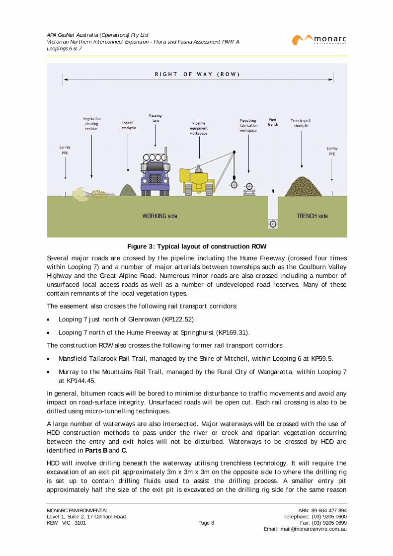
The typical layout of a construction ROW for a pipeline is provided in Figure 3 (note that this layout may be adjusted at certain locations depending on site conditions or construction method).
Temporary construction site depots will be required for each stage of the project as well as laydown areas for pipes, laying out the HDD pipestring and other working areas. These will be restored to their original form once construction is complete.
The topography of the construction ROW will be restored as much as possible to its original form and the land returned to its prior use once the pipeline has been installed and restoration work has been completed. Few indications of the presence of the pipeline will be visible apart from:
• Four above ground line valves (1 in Looping 6 and 3 in Looping 7) to be installed as parts of the project. The enclosures for these facilities will be placed next to the line valve enclosures of the existing pipeline and will encompass an area of no more than approximately 10m x 10m each.
• Pipeline marker posts and cathodic protection test boxes required by the pipeline licence and Australian Standard.
Key construction activities will involve civil works associated with pipeline construction and significant structural works at creek crossings, road crossings and rail crossings. Other activities will include clearing of vegetation, removal and/or relocation of above-ground structures (e.g. fencing), earthworks (including clear and grade, excavation, backfilling, topsoil spreading) and reinstatement of the land to its previous condition.
MONARC ENVIRONMENTAL ABN: 89 604 427 894 Level 1, Suite 2, 17 Cotham Road Telephone: (03) 9205 0600 KEW VIC 3101 Page 7 Fax: (03) 9205 0699
Email: [email protected]
APA GasNet Australia (Operations) Pty Ltd Victorian Northern Interconnect Expansion - Flora and Fauna Assessment PART A Loopings 6 & 7
Figure 3: Typical layout of construction ROW
Several major roads are crossed by the pipeline including the Hume Freeway (crossed four times within Looping 7) and a number of major arterials between townships such as the Goulburn Valley Highway and the Great Alpine Road. Numerous minor roads are also crossed including a number of unsurfaced local access roads as well as a number of undeveloped road reserves. Many of these contain remnants of the local vegetation types.
The easement also crosses the following rail transport corridors:
• Looping 7 just north of Glenrowan (KP122.52).
• Looping 7 north of the Hume Freeway at Springhurst (KP169.31).
The construction ROW also crosses the following former rail transport corridors:
• Mansfield-Tallarook Rail Trail, managed by the Shire of Mitchell, within Looping 6 at KP59.5.
• Murray to the Mountains Rail Trail, managed by the Rural City of Wangaratta, within Looping 7 at KP144.45.
In general, bitumen roads will be bored to minimise disturbance to traffic movements and avoid any impact on road-surface integrity. Unsurfaced roads will be open cut. Each rail crossing is also to be drilled using micro-tunnelling techniques.
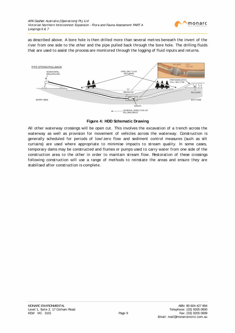
A large number of waterways are also intersected. Major waterways will be crossed with the use of HDD construction methods to pass under the river or creek and riparian vegetation occurring between the entry and exit holes will not be disturbed. Waterways to be crossed by HDD are identified in Parts B and C.
HDD will involve drilling beneath the waterway utilising trenchless technology. It will require the excavation of an exit pit approximately 3m x 3m x 3m on the opposite side to where the drilling rig is set up to contain drilling fluids used to assist the drilling process. A smaller entry pit approximately half the size of the exit pit is excavated on the drilling rig side for the same reason
MONARC ENVIRONMENTAL ABN: 89 604 427 894 Level 1, Suite 2, 17 Cotham Road Telephone: (03) 9205 0600 KEW VIC 3101 Page 8 Fax: (03) 9205 0699
Email: [email protected]
APA GasNet Australia (Operations) Pty Ltd Victorian Northern Interconnect Expansion - Flora and Fauna Assessment PART A Loopings 6 & 7
as described above. A bore hole is then drilled more than several metres beneath the invert of the river from one side to the other and the pipe pulled back through the bore hole. The drilling fluids that are used to assist the process are monitored through the logging of fluid inputs and returns.
Figure 4: HDD Schematic Drawing
All other waterway crossings will be open cut. This involves the excavation of a trench across the waterway as well as provision for movement of vehicles across the waterway. Construction is generally scheduled for periods of low/zero flow and sediment control measures (such as silt curtains) are used where appropriate to minimise impacts to stream quality. In some cases, temporary dams may be constructed and flumes or pumps used to carry water from one side of the construction area to the other in order to maintain stream flow. Restoration of these crossings following construction will use a range of methods to reinstate the areas and ensure they are stabilised after construction is complete.
MONARC ENVIRONMENTAL ABN: 89 604 427 894 Level 1, Suite 2, 17 Cotham Road Telephone: (03) 9205 0600 KEW VIC 3101 Page 9 Fax: (03) 9205 0699
Email: [email protected]
APA GasNet Australia (Operations) Pty Ltd Victorian Northern Interconnect Expansion - Flora and Fauna Assessment PART A Loopings 6 & 7
3. ENVIRONMENTAL SETTING
3.1 General
For the purposes of the assessment, three broad landform units have been identified along the construction ROW. These are:
• Foothills and forests on the northern slopes of the Victorian section of the Great Dividing Range.
• Northern Victorian plains between the Great Dividing Range and the Murray River.
• The northern inland slopes which consist of low hills of mixed geology that lie to the north of the Great Dividing Range. These are an extension of the NSW South Western Slopes, a large area of scattered foothills and minor ranges from the western fall of the Great Dividing Range that continue across the Murray River into Victoria.
The Victorian Government has prepared a Biodiversity Strategy that has divided Victoria into a number of bioregions based on a combination of biological and geographical criteria (landform, climate etc.). Bioregions are promoted for regional-scale biodiversity planning because they are based on patterns of ecological characteristics and the underlying environmental features. They are intended to reflect natural boundaries and relationships between biodiversity assets and natural resource based activities and the concept has therefore been adopted in Victoria's Biodiversity Strategy as well as in the Commonwealth Environment Protection and Biodiversity Conservation Act 1999 (EPBC Act).
While bioregion boundaries cannot be considered as rigid, based on current mapping, the construction ROW intersects three bioregions:
• Broadford to Mangalore (Looping 6) KP45.2 to KP61.9 Central Victorian Uplands (CVU)
KP61.9 to KP63.9 Victorian Riverina (VRiv)
KP63.9 to KP69.5 Central Victorian Uplands
KP69.5 to KP73.7 Victorian Riverina
KP73.7 to KP74.3 Central Victorian Uplands
• Glenrowan to Barnawartha (Looping 7) KP118.2 to KP124.4 Northern Inland Slopes (NIS)
KP124.4 to KP153.3 Victorian Riverina
KP153.3 to KP169.5 Northern Inland Slopes
KP169.5 to KP172.5 Victorian Riverina
KP172.5 to KP182.6 Northern Inland Slopes
KP182.6 to KP184.6 Victorian Riverina
Looping 6 commences in the foothills of the north-western slopes of the Great Dividing Range within the Central Victorian Uplands Bioregion. The topography consists of low rolling hills commencing at about 240m AHD at Strath Creek Road east of Broadford before dropping gradually through the foothills to about 150m at the Goulburn River. The construction ROW then continues through undulating country to finish south of Back Mountain Road at about 180m AHD.
Looping 7 commences just west of Glenrowan on the plains to the east of Benalla at about 180m AHD. The construction ROW then rises to approximately 250m as it passes around the southern
MONARC ENVIRONMENTAL ABN: 89 604 427 894 Level 1, Suite 2, 17 Cotham Road Telephone: (03) 9205 0600 KEW VIC 3101 Page 10 Fax: (03) 9205 0699
Email: [email protected]
APA GasNet Australia (Operations) Pty Ltd Victorian Northern Interconnect Expansion - Flora and Fauna Assessment PART A Loopings 6 & 7
perimeter of the Warby Range on the northern side of the Glenrowan Township. As the construction ROW heads in a north-easterly direction it drops to an elevation of about 150m on the floodplain to the east of Wangaratta before entering rolling hills just south of Springhurst. Here it rises to about 270m before dropping back to about 200m near the fourth Hume Freeway crossing. The construction ROW then rises again to a maximum of about 270m as it passes through the national park to the north of Chiltern before dropping back again to about 170m at Barnawartha.
Notable ecological features of the bioregions are summarised below:
• The Central Victorian Uplands which borders the northern edge of the Victorian Highlands is part of a larger region known as the Victorian Midlands which stretches east-west across central Victoria. This region has undulating terrain and was formerly dominated by foothill forest, some of which is still found on the upper slopes. The flatter and more fertile areas are largely cleared for agriculture. Dry Foothill Forest Complexes dominated the Central Victorian Uplands but large areas of Moist Foothill Forest Complexes and Valley Grassy Woodland Complexes also occurred.
• The Victorian Riverina consists of a flat to gently sloping riverine plain formed from Quaternary alluvial deposits associated with the eight river basin tributaries of the Murray River. Prior to European settlement, the vegetation of the Victorian Riverina was a mixture of grasslands and low open woodland, dominated by box species (Grey Box Eucalyptus microcarpa and Yellow Box E. melliodora), red gum and Murray-pine (Callitris), with a sparse grassy understorey. A number of small freshwater wetlands of various types were also scattered across the region with concentrations of large and shallow wetlands adjacent to the major rivers in a few locations, such as around Wangaratta.
Today, over 90% of the area is cleared, mainly for dryland farming involving grazing and mixed cropping. As a result, the once-extensive woodlands are largely cleared, the remnants containing predominantly Grey Box with grassy understorey and scattered shrubs. Networks of vegetated roadsides and creeklines now play an important role in sustaining biodiversity across this highly modified landscape (GBCMA 2003). Creekline vegetation remnants can retain good connectivity, while the networks of road reserves and associated vegetation can not only provide important habitat for native bird species but also for colonies of gliders and other mammals. Other threatened fauna in the area includes Bush Stone-curlew Burhinus grallarius, Swift Parrot Lathamus discolor, Tree Goanna Varanus varius and Brush-tailed Phascogale Phascogale tapoatafa tapoatafa which are often found along connected creeklines and roadsides with large, old, hollow-bearing trees.
• The Northern Inland Slopes are comprised of the lower foothills north of the Great Dividing Range with minor ranges separated by river valleys. The pre-European vegetation primarily consisted of box ironbark forest (though notably lacking ironbark species) in the hills, with grassy woodland on the lower slopes and areas of gilgai plain woodland/wetland mosaic fringing the riverine plain (GBCMA 2003). The remaining hills vegetation was dominated by Grey Box, Red Box E. polyanthemos and White Box E. albens with an understorey frequently dominated by wattles and a sparse ground layer.
MONARC ENVIRONMENTAL ABN: 89 604 427 894 Level 1, Suite 2, 17 Cotham Road Telephone: (03) 9205 0600 KEW VIC 3101 Page 11 Fax: (03) 9205 0699
Email: [email protected]
APA GasNet Australia (Operations) Pty Ltd Victorian Northern Interconnect Expansion - Flora and Fauna Assessment PART A Loopings 6 & 7
3.2 Land Use
The route of the construction ROW passes through the following planning schemes:
• Shire of Mitchell KP45.2 to KP74.3 Looping 6
• Benalla Rural City KP118.2 to KP118.6 Looping 7
• Wangaratta Rural City KP118.6 to KP166.2 Looping 7
• Shire of Indigo KP166.2 to KP184.6 Looping 7
Land usage in the area is predominantly rural with the majority of the land classed as a Farming Zone. The greater part of the region retains an open aspect typical of grazing land and much of this land is subject to either sheep or cattle grazing. While much of the private land has been cleared for agricultural purposes, many areas have retained a number of the larger old trees as part of the landscape.
Land in the region is predominantly freehold. However, the construction ROW also intersects a number of areas of Crown Land being:
• Roads and associated roads reserves. These include the Hume Freeway, highways, rural roads and a number of undeveloped and unnamed road reservations, some with rough tracks (generally referred to in this document as ‘Government Road’). While private land in the area has often been subject to development for agricultural purposes, roadside reserves often contain remnant native vegetation, particularly within undeveloped road reserves or partially developed road reserves.
• Rail lines managed by VicTrack (Looping 7: KP122.52 and KP169.31).
• Land associated with a number of major waterways intersected by the construction ROW classed as water frontage reserves.
• Murray to The Mountains Rail Trail (KP144.45) categorised as a recreation reserve.
• Uncategorised Public Land such as that surrounding the Mansfield-Tallarook Rail Trail (KP59.5).
• Chiltern - Mt. Pilot National Park north of Chiltern (in the area of KP175.0 to KP178.8).
It is noted that an easement does not apply within Crown Land and that in these sections the pipeline operates under an agreement with the State Government (Agreement concerning GPU GasNet Operations on Crown Land between Governor in Council and GPU GasNet Pty Ltd, dated 18 April 2001).
Environmental issues of local or regional importance or concern may be recognised under local government planning schemes by the application of environmental overlays or local management requirements regarding vegetation management. These are discussed within the sections relevant to each looping (Parts B and C of this report).
Note that all LGAs have prepared roadside management plans that identify and categorise roadside vegetation considered to have conservation significance.
In general, the plans cover all rural road reserves in each LGA excluding any road reserves under the management of VicRoads (e.g. arterial roads or highways) or unused roads under the management of DELWP. While there is some variation in definition, roadsides have been generally assigned to one of three rankings:
MONARC ENVIRONMENTAL ABN: 89 604 427 894 Level 1, Suite 2, 17 Cotham Road Telephone: (03) 9205 0600 KEW VIC 3101 Page 12 Fax: (03) 9205 0699
Email: [email protected]
APA GasNet Australia (Operations) Pty Ltd Victorian Northern Interconnect Expansion - Flora and Fauna Assessment PART A Loopings 6 & 7
• Low - predominately non-native vegetation with low natural regenerative capacity and few
habitat features.
• Medium – native vegetation in patches with only moderate disturbance and weed levels and with potential to improve conservation values by changes to management and or revegetation.
• High – good representation of native vegetation layers with relatively lower level of disturbance and weed levels; area may form a wildlife corridor and is linked to other native vegetation.
A number of roads intersected by the each of the loopings have been assigned a ranking of High Conservation value. Many of the roads considered to have special value (such as providing habitat for significant species like the Grey-crowned Babbler Pomatostomus temporalis temporalis) have been identified by on-site signage to identify areas as Significant Roadside Area.
Each LGA has also been consulted for any planning controls applied to non-native vegetation such as Heritage Overlays or significant tree status. No such controls apply to the area intersected by the construction ROW.
3.3 Waterways
Natural assets that have been identified along the construction ROW include several perennial waterways as well as some ephemeral waterways. In general, natural waterways and drainage lines (designated waterways under the Victorian Water Act 1989) are the responsibility of the relevant Catchment Management Authority (CMA). In summary:
• Broadford to Mangalore (Looping 6) intersects 25 designated waterways of which 4 are named. This includes the Goulburn River.
• Glenrowan to Barnawartha (Looping 7) intersects 48 designated waterways of which 14 are named. This includes the Ovens and King Rivers.
While there are a number of perennial waterways intersected by the study area (such as the Goulburn, King and Ovens Rivers), many waterways are ephemeral and generally flow only when rainfall conditions are sufficient. Water flow within these waterways may therefore vary from a few hours or days following a storm event (ephemeral) to a few weeks or months (intermittent). All designated waterways intersected by the construction ROW within Looping 6 drain to the Goulburn River while those within Looping 7 drain to the Murray River.
Most of the minor waterways intersected by the construction ROW fall within private freehold land, however a number also fall within Crown Land. Under the Flora and Fauna Guarantee Act 1988 (FFG Act), a permit is required to remove threatened species from Crown Land as well as a number of additional species identified as protected flora on Crown Land (refer Section 4.2.4). A permit will therefore be required prior to vegetation clearing on Crown Land intersected by the construction ROW.
There are also a number of dams either on, adjacent to, or near the construction ROW including a number of dams that are down-gradient of the construction ROW. These vary from stock-watering dams in the middle of paddocks with little vegetation of value, dams along drainage lines/waterways with minimal fringing vegetation to dams or pondage with significant amounts of emergent, fringing and/or terrestrial vegetation. As a result, their habitat value varies. However, any dams within the construction ROW could be habitat for native species and may therefore require a licence under the Wildlife Act 1975 and/or Water Act 1989 should they be disturbed.
MONARC ENVIRONMENTAL ABN: 89 604 427 894 Level 1, Suite 2, 17 Cotham Road Telephone: (03) 9205 0600 KEW VIC 3101 Page 13 Fax: (03) 9205 0699
Email: [email protected]
APA GasNet Australia (Operations) Pty Ltd Victorian Northern Interconnect Expansion - Flora and Fauna Assessment PART A Loopings 6 & 7
3.4 Previous Studies
A number of Conservation Management Plans have been prepared by the Catchment Management Authorities to identify priorities for native biodiversity conservation in the region managed by the CMA. In Victoria, these have been prepared in accordance with DSE Biodiversity Action Planning objectives as part of the Victorian Biodiversity Strategy and have identified a number of priority sites likely to have conservation values.
Key biodiversity assets identified in the plans include examples of Ecological Vegetation Class (EVC), waterways and their riparian margins, wetlands and roadside vegetation. While a number of examples of each of these assets are identified for management, roadsides in particular have been noted to be an important part of conservation planning as not only do they often contain elements of remnant vegetation that provide linkages across the landscape, they also often contain large old trees with hollows. One of the objectives of these management plans is to enhance roadsides by encouraging adjacent landowners to widen roads to at least 40m.
MONARC ENVIRONMENTAL ABN: 89 604 427 894 Level 1, Suite 2, 17 Cotham Road Telephone: (03) 9205 0600 KEW VIC 3101 Page 14 Fax: (03) 9205 0699
Email: [email protected]
APA GasNet Australia (Operations) Pty Ltd Victorian Northern Interconnect Expansion - Flora and Fauna Assessment PART A Loopings 6 & 7
4. LEGISLATIVE REVIEW
Legislative obligations with respect to flora and fauna are identified and briefly reviewed below. Legislation implications for each looping project are discussed in Parts B and C of this report.
4.1 Commonwealth Legislation
The Environment Protection and Biodiversity Conservation Act 1999 establishes a Commonwealth process for the assessment of proposed actions that are likely to have a significant impact on matters of national environmental significance (MNES) or on Commonwealth land. An action, unless otherwise exempt, requires approval from the Commonwealth Environment Minister if it is considered likely to have an impact on one or more of the nine MNES to which the EPBC Act applies. These include:
1. World Heritage properties
2. National Heritage places
3. Wetlands of international importance (e.g. Ramsar wetlands)
4. Nationally threatened species and ecological communities
5. Migratory species
6. Commonwealth marine areas
7. Great Barrier Reef Marine Park
8. Nuclear actions (including uranium mining)
9. A water resource, in relation to coal seam gas development and large coal mining development
Items 1 and 6 to 9 do not apply to the proposed action or this report. However, a number of threatened species and ecological communities listed under the EPBC Act have been identified as potentially occurring in the construction ROW. These are discussed within the sections of this report dedicated to each looping.
Note that referrals to the Minister are required to identify whether the project is a component of a larger action or whether the project is related to any actions or proposals in the region. While construction of each looping section is considered to be independent of the other looping, these projects are considered likely to have an impact on a MNES and therefore a referral is required.
In addition, the Australian Government released an Environmental Offsets Policy in late 2012 (DSEWPaC 2012a). These are defined as measures that compensate for the residual adverse impacts of an action on the environment after avoidance and mitigation measures have been implemented.
The offsets policy does not apply to actions that have been declared as ‘Not a Controlled Action’ and are only required if residual impacts of a project declared as a ‘Controlled Action’ are considered significant (that is, after all appropriate mitigation measures have been considered). They are not required for all approvals under the EPBC Act and do not mean that proposals with unacceptable impacts will be approved. When they are deemed to be required, they may be additional to that already required under State laws although the policy does not preclude the recognition of State offsets that may be suitable as offsets under the EPBC Act for the same action.
MONARC ENVIRONMENTAL ABN: 89 604 427 894 Level 1, Suite 2, 17 Cotham Road Telephone: (03) 9205 0600 KEW VIC 3101 Page 15 Fax: (03) 9205 0699
Email: [email protected]
APA GasNet Australia (Operations) Pty Ltd Victorian Northern Interconnect Expansion - Flora and Fauna Assessment PART A Loopings 6 & 7
4.2 Victorian Legislation
The main Victorian based legislation of potential relevance to the development that may impact on the management of environmental issues are:
• Catchment and Land Protection Act 1994
• Environment Effects Act 1978
• Fisheries Act 1995
• Flora and Fauna Guarantee Act 1988
• National Parks Act 1975
• Pipelines Act 2005
• Planning and Environment Act 1987
• Water Act 1989
• Wildlife Act 1975
4.2.1 Catchment and Land Protection Act 1994
The Catchment and Land Protection Act (CaLP Act) contains provisions relating to catchment planning, land management, noxious weeds and pest animals. The Act also provides a legislative framework for the management of private and public land and sets out the responsibilities of land managers, stating that they must take all reasonable steps to:
• Avoid causing or contributing to land degradation which causes or may cause damage to land of another land owner.
• Protect water resources.
• Conserve soil.
• Eradicate regionally prohibited weeds.
• Prevent the growth and spread of regionally controlled weeds.
• Prevent the spread of, and as far as possible eradicate, established pest animals.
The construction ROW contains a number of noxious weeds listed as regionally controlled within the GBCMA and/or NECMA regions. These are listed in the sections of this report relevant to each looping and summarised in Section 5.4.4. Appropriate weed control and hygiene measures should be implemented when removing vegetation in the construction ROW to ensure noxious weeds are not spread within, from or to the area.
4.2.2 Environment Effects Act 1978
The Environment Effects Act (EE Act) requires the preparation of an Environment Effects Statement (EES) where proposed works may potentially have a significant effect on the environment. An EES is typically required where it is considered that there is a likelihood of regionally or State significant adverse effects on the environment. These may include effects on the biological and physical environment but also include consideration of economic, social, health, cultural and landscape values.
MONARC ENVIRONMENTAL ABN: 89 604 427 894 Level 1, Suite 2, 17 Cotham Road Telephone: (03) 9205 0600 KEW VIC 3101 Page 16 Fax: (03) 9205 0699
Email: [email protected]
APA GasNet Australia (Operations) Pty Ltd Victorian Northern Interconnect Expansion - Flora and Fauna Assessment PART A Loopings 6 & 7
A project with potential adverse environmental effects that individually or in combination could be significant in a regional or State context should generally be referred to the Minister administering the EE Act to determine whether an EES is required. Guidance on the criteria for referral covers both individual potential environmental effects (such as loss of a significant proportion of habitat of a threatened species) as well as a combination of potential environmental effects.
They include the following matters related to flora and fauna (DSE 2006a):
• Potential clearing of 10ha or more of native vegetation from an area that:
o Is of an Ecological Vegetation Class identified as endangered by DELWP.
o Is, or is likely to be, of very high conservation significance.
o Is not authorised under an approved Forest Management Plan or Fire Protection Plan.
• Matters listed under the Flora and Fauna Guarantee Act 1988 such as:
o Potential loss of a significant area of a listed ecological community.
o Potential loss of a genetically important population of an endangered or threatened species.
o Potential loss of critical habitat.
o Potential significant effects on habitat values of a wetland supporting migratory bird species.
• Potential major effects on landscape values of regional importance, especially where recognised by a planning scheme overlay.
The most significant issue for the project in terms of the criteria for an EES referral is likely to be the amount of native vegetation that will be required to be removed in order to allow construction to proceed.
Note that the triggers for a potential EES referral with respect to native vegetation are based on the Native Vegetation Management Framework (DNRE 2002) which was replaced by the Permitted Clearing Guidelines (DEPI 2013a) in December 2013 (refer Section 4.3). The Permitted Clearing Guidelines assessment guidelines do not require consideration of the bioregional conservation status of vegetation classes as described in the referral guidelines (refer Section 4.3). This report has therefore considered the requirements of both the Native Vegetation Management Framework (NVMF) and Permitted Clearing Guidelines when determining obligations that may be applicable to the project.
Note that referrals to the Minister are required to identify whether the project is an element or stage in a larger project or whether the project is related to any other past, current or future proposal in the region. While construction of each looping section is considered to be independent of other loopings, the project will therefore require referral of all sections of the project as a whole in the event that one or more loopings meets the criteria for referral.
4.2.3 Fisheries Act 1995
The Fisheries Act provides a legislative framework for the regulation, management and conservation of Victorian fisheries, including aquatic habitats.
A person must not take, injure, damage, destroy, possess, keep or release into Victorian waters any protected aquatic biota without a permit or unless authorised to do so. Protected aquatic biota includes any taxon of fish or aquatic invertebrate listed under the FFG Act.
MONARC ENVIRONMENTAL ABN: 89 604 427 894 Level 1, Suite 2, 17 Cotham Road Telephone: (03) 9205 0600 KEW VIC 3101 Page 17 Fax: (03) 9205 0699
Email: [email protected]
APA GasNet Australia (Operations) Pty Ltd Victorian Northern Interconnect Expansion - Flora and Fauna Assessment PART A Loopings 6 & 7
A permit will be required under the Fisheries Act for salvage activities requiring the handling of threatened and common fish species and threatened aquatic invertebrates.
4.2.4 Flora and Fauna Guarantee Act 1988
The Flora and Fauna Guarantee Act (FFG Act) is the primary legislation for the protection of threatened native flora and fauna within Victoria. The Act includes the following lists:
• Threatened native flora and fauna.
• Threatened communities of native flora and fauna.
• Protected flora.
• Potentially threatening processes.
The FFG Act applies to all Crown Land and permits are required under the FFG Act for the taking of listed and protected species in these areas.
4.2.5 National Parks Act 1975
The National Parks Act (National Parks Act) 1975, and its subordinate National Parks Regulations 2013, provides the legislative mechanisms for the regulation and management of parks within Victoria. The general objective of these documents is to ensure the protection of the parks and the preservation of the values they support, whether they are of biological, geological, scenic, historical, archaeological or social significance. The Act also identifies the value of parks as water supply catchment areas and the important role they play in providing enjoyment, recreation and education for visitors.
Chiltern - Mt. Pilot National Park, which contains sections of Looping 7 within its boundary, is a declared National Park under Schedule Two of the National Parks Act 1975. The existing pipeline was installed prior to this area being originally incorporated into the National Parks Act in 1980 and amended to its current state in 2002. Consent for the pipeline corridor within Crown Land, including the portion that lies within the boundaries of the Park, is covered by a Governor-in-Council order. The existing pipeline and license area operates under a Crown Land agreement between the State Government and the predecessor to APA (GPU Gasnet Pty Ltd) which was put in place in 2001. Under this agreement, approval is required from the Minister for works upon Crown land.
MONARC ENVIRONMENTAL ABN: 89 604 427 894 Level 1, Suite 2, 17 Cotham Road Telephone: (03) 9205 0600 KEW VIC 3101 Page 18 Fax: (03) 9205 0699
Email: [email protected]
APA GasNet Australia (Operations) Pty Ltd Victorian Northern Interconnect Expansion - Flora and Fauna Assessment PART A Loopings 6 & 7
4.2.6 Pipelines Act 2005
In Victoria, onshore natural gas pipelines with an operating pressure above 1,050kPa require licensing under the Pipelines Act 2005 (Pipelines Act) which is administered by Earth Resources Regulation within the Department of Economic Development, Jobs, Transport and Resources (DEDJTR) together with Energy Safe Victoria (ESV).
Section 85 of the Pipelines Act provides that a pipeline issued with a licence under the Act is exempt from the requirements for a permit in a planning scheme under the Planning and Environment Act 1987 (refer Section 4.2.6). This includes any permits that may be required for construction including those associated with vegetation removal.
However, it does not provide for exemptions under any other Act. Therefore any proposed works, including vegetation removal, would still need to take account of potential issues such as:
• Whether an action is likely to impact on a matter of national environmental significance under the EPBC Act.
• Whether fauna or flora species listed under the FFG Act are present.
In addition, agreements between the pipeline regulator and other government departments ensure that relevant government policies such as State Environment Protection Policies or those related to vegetation management still apply.
Approval to construct a pipeline is issued following acceptance of a Construction Safety Management Plan (CSMP) and a Construction Environment Management Plan (CEMP). Consent to construct is not issued until ESV and DEDJTR are satisfied that all relevant issues are appropriately resolved.
4.2.7 Planning and Environment Act 1987
The Planning and Environment Act (P&E Act) is the main State legislation governing the use (zoning), development and environmental protection of land in Victoria. The planning legislation provides a framework for integrating planning policies and environmental considerations (e.g. clearing of native vegetation) on local, regional and the State levels; for example the clearing of native vegetation, through instruments such as planning permits.
While the Pipelines Act provides an exemption from the requirements for permits under the P&E Act, all such projects are still required to conform to the requirements of government policy (refer Section 4.3 Permitted Clearing Regulations).
4.2.8 Water Act 1989
The purposes of the Water Act are diverse. In part the Act relates to the orderly, efficient and sustainable use of water resources. This includes the integrated management of all elements of the terrestrial phase of the water cycle, formal means for the protection and enhancement of the environmental qualities of waterways and their in-stream uses and to make sure that water resources are conserved and properly managed for sustainable use for the benefit of present and future Victorians.
A permit to construct (Works on Waterways Licence) will be required from the relevant CMA for the crossing of all designated waterways along the construction ROW.
MONARC ENVIRONMENTAL ABN: 89 604 427 894 Level 1, Suite 2, 17 Cotham Road Telephone: (03) 9205 0600 KEW VIC 3101 Page 19 Fax: (03) 9205 0699
Email: [email protected]
APA GasNet Australia (Operations) Pty Ltd Victorian Northern Interconnect Expansion - Flora and Fauna Assessment PART A Loopings 6 & 7
4.2.9 Wildlife Act 1975
The main legislation for protecting and managing fauna in Victoria is the Wildlife Act. This covers indigenous vertebrate species (except declared pest species), invertebrate species listed under the FFG Act and some introduced game species but does not apply to fish, these are defined under the Fisheries Act 1995.
A Management Authorization permit will be required under the Act if salvage and relocation of fauna are to be undertaken as part of any mitigation measures for the project.
4.3 Permitted Clearing Regulations
In Victoria, a permit is required to remove, destroy or lop native vegetation. Responsibilities for the clearance of native vegetation are referenced under the P&E Act and are generally enacted under the municipal planning scheme via Clause 52.17 of the Victorian Planning Provisions (VPP).
In December 2013, the Victorian State Government released a set of reforms to replace the former Native Vegetation Management Framework (DEPI 2013a). This uses risk-based pathways, based on the extent of vegetation removed and the location risk, to regulate the approval and conditions association with vegetation clearing.
The Permitted clearing of native vegetation – Biodiversity assessment guidelines (the Guidelines) outline how impacts on Victoria's biodiversity are assessed when an application to remove native vegetation is lodged (DEPI 2013a). The Guidelines are an incorporated document in all Victorian Planning Schemes.
The Guidelines are applied alongside other requirements of the planning scheme when an application for a permit to remove native vegetation is considered by the responsible authority.
The objective of the new guidelines is to ensure ‘no net loss in the contribution made by native vegetation to Victoria’s biodiversity’ (DEPI 2013a). Native vegetation permitted to be cleared may therefore be required to be offset by the planting, protection and management of other native vegetation. Under the new guidelines, these offsets are required to be secured before clearing is approved either:
• Via a security agreement for the offset site that includes an onsite management plan.
• Evidence of a secured third party offset, such as an allocated credit register extract from the native vegetation credit register.
While the Pipelines Act provides an exemption from the requirements for permits under the P&E Act, an agreement between the regulators of the Pipelines Act and the department responsible for protection of the environment require that the principles of native vegetation management regarding the removal of native vegetation be met.
It is noted, however, that discussions between the pipeline regulator and DELWP have agreed that, where works are to occur in an existing easement, that the area of the easement that can be shown to be regularly inspected and maintained in accordance with the Pipelines Act and AS2885 will be exempt from vegetation offsets where it is to be disturbed as part of further pipeline construction activities. The exception to this would be where vegetation within these areas has not been previously disturbed and would now be impacted by project activities. In this instance, these areas would require to be offset in accordance with the Permitted Clearing Guidelines.
Note that a permit to remove native vegetation does not replace any requirements under the FFG Act and the Commonwealth EPBC Act.
MONARC ENVIRONMENTAL ABN: 89 604 427 894 Level 1, Suite 2, 17 Cotham Road Telephone: (03) 9205 0600 KEW VIC 3101 Page 20 Fax: (03) 9205 0699
Email: [email protected]
APA GasNet Australia (Operations) Pty Ltd Victorian Northern Interconnect Expansion - Flora and Fauna Assessment PART A Loopings 6 & 7
5. ASSESSMENT METHODOLOGY
Each looping project has been assessed to:
• Determine native vegetation and general ecological status of the construction ROW.
• Identify areas of remnant vegetation and scattered trees within the construction ROW that would require a Habitat Hectares assessment under the native vegetation permitted clearing regulations should they require removal.
• Identify key ecological values and habitats within the construction ROW and potential impacts of proposed construction activities.
• Identify potential field surveys targeting those threatened flora and fauna species that may potentially be found along or near the construction ROW within habitat types identified during the preliminary survey.
The following section discusses methodologies utilised in both loopings to:
1. Assess native vegetation intersected by the construction ROW.
2. Determine species of significance that may be expected to occur within the vicinity of each looping.
3. Determine species of significance that may potentially utilise habitat found within the construction ROW and therefore require survey to determine the potential impact of construction.
4. Determine locations within the construction ROW requiring survey for the significant species identified for survey.
It concludes with a discussion of methodologies utilised in both loopings to survey for the targeted species and any limitations of the assessment.
Note that identification numbers utilised by Monarc to describe properties intersected by the construction ROW are based on mapping provided by APA. Property numbers are included in all detailed route maps included within Parts B and C of this report.
5.1 Literature and Database Review
In order to provide context for the project area, records for flora and fauna within 5km of the project area were obtained from relevant and literature public databases. Information sources used for the flora and fauna assessment include:
• The Victorian Biodiversity Atlas (VBA), the database maintained by DELWP of records of flora and fauna sightings across Victoria (DEPI 2014a; DEPI 2014b).
• The Protected Matters Search Tool (PMST) maintained by the Commonwealth Department of the Environment (DoE), a predictive database that identifies nationally listed species and communities that may occur in a given search area (DoE 2014a, DoE 2015).
• Biodiversity Interactive Maps maintained by DELWP that identify historic and extant Ecological Vegetation Classes, Bioregions and key ecological values across Victoria (known as the Biodiversity Information Management System or BIMS) (DEPI 2014c).
MONARC ENVIRONMENTAL ABN: 89 604 427 894 Level 1, Suite 2, 17 Cotham Road Telephone: (03) 9205 0600 KEW VIC 3101 Page 21 Fax: (03) 9205 0699
Email: [email protected]
APA GasNet Australia (Operations) Pty Ltd Victorian Northern Interconnect Expansion - Flora and Fauna Assessment PART A Loopings 6 & 7
• Local Government Authority Planning Schemes along with any associated environmental studies
to ascertain current zoning and environmental overlays (DELWP 2015a; DTPLI 2014).
• Geospatial databases maintained by the CMA as part of their Biodiversity Action Planning process to identify priority sites for management with regard to native species.
• Literature reviews for targeted species and communities including:
• Species Profile and Threats database (SPRAT) maintained by DoE for EPBC Act listed species including relevant species impact guidelines, policy statements and recovery plans.
• Actions Statements and Listing Advice prepared by/for DELWP (or it former incarnations) on State listed threatened species and/or communities.
• Regional management plans prepared by GBCMA and NECMA to identify priorities for native biodiversity conservation in the region.
• Parks Victoria Management Plan for Chiltern - Mt. Pilot National Park (Parks Victoria, 2008).
• Discussions with DELWP officers regarding local species records.
5.2 Database Review
A search was undertaken in relation to species listed under the EPBC Act with a buffer of 5km for listed species and vegetation communities that may occur in the area of each construction ROW. The results of the searches are provided in Parts B and C.
A search of the VBA was also conducted for each looping over a linear search area along the construction ROW with a buffer of 5km to obtain a species profile for the area from records maintained by DELWP. The database records sightings of all species reported to DELWP (including the locality and date of sighting) and indicates whether species are listed under the EPBC Act, the State FFG Act or DELWP Advisory Lists (DEPI 2014d; DSE 2013; DSE 2009). Results of these database searches are provided in Parts B and C.
Information from both databases was then compiled to obtain a preliminary listing of species that may be expected within the vicinity of each of the loopings. Where indicated, additional species were added to the listing following discussions with DELWP officers or other credible sources.
5.3 Preliminary Assessment
A preliminary inspection of the construction ROW was undertaken by qualified and experienced ecologists from Monarc on separate occasions:
• The area covered by Looping 6 was inspected from 4 to 22 June 2012.
• The area covered by Looping 7 was inspected from 30 January to 14 February 2013.
The purpose of the preliminary assessment was to gain an understanding of the type and variability of vegetation and habitats within the construction ROW and the potential for the vegetation to provide habitat for any threatened flora or fauna. Any significant areas of vegetation (areas requiring a habitat hectare assessment, location of scattered trees and vegetation communities or other potential habitat for threatened species) were recorded and mapped by a hand held geographical positioning system unit (GPS). This was used to help determine and guide the development of the detailed surveys (i.e. areas requiring assessment for Net Gain or for targeted
MONARC ENVIRONMENTAL ABN: 89 604 427 894 Level 1, Suite 2, 17 Cotham Road Telephone: (03) 9205 0600 KEW VIC 3101 Page 22 Fax: (03) 9205 0699
Email: [email protected]
APA GasNet Australia (Operations) Pty Ltd Victorian Northern Interconnect Expansion - Flora and Fauna Assessment PART A Loopings 6 & 7
surveys for threatened flora and fauna) which were implemented at a season/time appropriate to the maximum chance of detecting the species (if present).
Both surveys used three teams of two people with at least one person per team qualified under the DELWP Vegetation Quality Assessment scheme for assessment of remnant native vegetation.
5.4 Vegetation Assessment and Permitted Clearing Assessment
Targeted vegetation assessments were undertaken across both looping sections in spring 2013. These assessments, to determine the implications for clearance of native vegetation within the construction ROW, were based on the Permitted clearing of native vegetation – Biodiversity assessment guidelines (DEPI 2013a).
Based on the location of the project and amount of native vegetation to be impacted by the construction ROW, each looping falls under the ‘Moderate’ or ‘High’ risk based pathway according to these guidelines. This requires applications to remove native vegetation to include the following:
• A habitat hectare assessment of the native vegetation to be removed.
• A statement outlining what steps have been taken to ensure that impacts on biodiversity from the removal of native vegetation have been minimised.
• An assessment of whether the removal of native vegetation will have a significant impact on biodiversity with regard to the impact on habitat for rare or threatened species.
• An offset strategy that details how an offset will be secured to counteract the impacts of native vegetation removal.
At the time of the surveys (October to November 2013), the NVMF was still applicable. All surveys were therefore undertaken in accordance with the Framework (DNRE 2002). This required an in-field habitat hectare and scattered tree assessment of the construction ROW which was mapped using GIS tools to clearly identify the extent of remnant native vegetation and the number of scattered trees proposed for removal.
All assessments have subsequently been adapted to the method described in the Guidelines released by DEPI (DEPI 2014e). To facilitate transfer from the NVMF to the Guidelines, DELWP established transition arrangements for applicants who have already undertaken an assessment of vegetation clearing requirements prior to the approval of the new Guidelines (DEPI 2014e). Under these arrangements the applicant may submit the assessment data to DELWP who will provide the requisite offset requirements under the Guidelines and produce a Biodiversity impact and offset requirements report (BIOR Report). This DELWP report provides biodiversity information for applications that fall within a moderate and high risk-based pathway, for the approval to remove native vegetation under clause 52.16 or 52.17 of the planning schemes in Victoria.
5.4.1 Habitat Hectares Assessment
Habitat hectare assessments of the construction ROW were undertaken between October and November 2013. All patches of remnant native vegetation were compared to historic and current mapping of Ecological Vegetation Classes (EVC) prepared by DELWP and the relevant benchmark for the EVC. The overall condition of the vegetation was scored and mapped onto a Nomad Trimble Personal Digital Assistant (PDA) with ArcPad 8.0 software.
All vegetation within the construction ROW was assessed according to the habitat hectare methodology described in the Vegetation Quality Assessment Manual prepared by the State Government (DSE 2004a). A habitat hectare is a unit of measurement, which combines both quality
MONARC ENVIRONMENTAL ABN: 89 604 427 894 Level 1, Suite 2, 17 Cotham Road Telephone: (03) 9205 0600 KEW VIC 3101 Page 23 Fax: (03) 9205 0699
Email: [email protected]
APA GasNet Australia (Operations) Pty Ltd Victorian Northern Interconnect Expansion - Flora and Fauna Assessment PART A Loopings 6 & 7
(relative to an EVC Benchmark) and quantity (EVC type) for a habitat zone. Vegetation community names follow Ecological Vegetation Class benchmarks relevant to each bioregion intersected by the project (DEPI 2014f).
Based on the discussion between the pipeline regulator and DELWP, as mentioned above in Section 4.2.6, the habitat hectare assessments were filtered by the mentioned exemption to arrive at the final habitat hectare figures summarized in Section 6.1 below. Figures for each looping are further discussed in Parts B and C.
Note that the assessment of vegetation quality only applies to the area intersected by the construction ROW. Any judgment about the quality of vegetation outside these areas (for instance when assessing the impact of proposed works on patches of remnant vegetation that extend beyond the construction ROW) is based on modelling of vegetation types by DELWP (refer to the Biodiversity Information Management System).
5.4.2 Indigenous Tree Assessment
All trees within remnant patches were assessed according to the Framework, based on the Diameter at Breast Height (DBH), to determine their size class and also mapped onto the PDA.
Scattered indigenous trees (i.e. those not located within a remnant patch of vegetation) were also mapped and the species, size class (compared with the relevant EVC benchmark) and the conservation significance of each tree was determined (DSE 2007a). Trees were assigned to one of the following categories:
• Very Large Old Tree (VLOT) is a tree with a DBH equal to or greater than 1.5 times the large tree diameter in the relevant EVC benchmark.
• Large Old Tree (LOT) is a tree with a DBH equal to or greater than the large tree diameter specified in the relevant EVC benchmark but less than the DBH for VLOT.
• Medium Old Tree (MOT) is a tree with a DBH equal to or greater than 0.75 of the large tree diameter specified in the relevant EVC benchmark but less than the DBH for LOT.
• Small Tree (ST) is a tree with a DBH equal to or greater than 0.25 of the large tree diameter specified in the relevant EVC benchmark but less than the DBH for a MOT.
Scattered trees were assessed in accordance with the Framework and data for any trees identified for removal was provided to DELWP for translation into the offset requirements under the new Biodiversity assessment guidelines (DEPI 2013a).
5.4.3 Planted Vegetation
The construction ROW intersects a number of areas with planted vegetation. This may consist of:
• Planted native vegetation indigenous to the area.
• Planted native vegetation that is not indigenous to the area.
• Planted exotic vegetation.
Examples of planted vegetation intersected by the construction ROW include:
• Paddocks sown with exotic pasture grasses.
• Timber plantations.
• Revegetation areas.
MONARC ENVIRONMENTAL ABN: 89 604 427 894 Level 1, Suite 2, 17 Cotham Road Telephone: (03) 9205 0600 KEW VIC 3101 Page 24 Fax: (03) 9205 0699
Email: [email protected]
APA GasNet Australia (Operations) Pty Ltd Victorian Northern Interconnect Expansion - Flora and Fauna Assessment PART A Loopings 6 & 7
• Plantings along driveways or other access routes.
• Planted shelter belts.
The latter have generally been placed along property boundaries to provide wind breaks or shelter for stock and may consist of non-indigenous native tree species, indigenous native tree species or exotic species.
Non-native vegetation is generally considered of limited value for most significant native fauna species. While such areas may provide habitat for some of the more common native species (including nesting sites), non-native vegetation is generally considered to provide limited habitat opportunities for threatened native species.
In addition, planted vegetation, unless publicly funded as part of a revegetation project as outlined in Clause 52.17 of the Victorian Planning Provisions, falls outside the definition of native vegetation and does not require assessment under the permitted clearing regulations. It is understood that APA will discuss any potential impacts of construction on planted vegetation directly with the landholders.
There are a number of areas intersected by the construction ROW however, that have resulted from publicly funded revegetation projects. These areas have been confirmed by APA with the respective landowner or manager. These areas have been identified in the relevant report for each looping and have been included in the calculations for vegetation offset requirements (refer Section 5.4.5).
5.4.4 Weeds
Under the CaLP Act, landholders have a duty to prevent the growth and spread of regionally controlled weeds on their property and on adjoining roadsides and to eradicate regionally prohibited weeds. Declaration and management of weed issues within these catchments are undertaken by the GBCMA or NECMA.
The field surveys noted the prevalence of opportunistic weed infestations throughout the construction ROW and surrounding areas, particularly in agricultural properties. These include common and widely distributed weed species like Plantain Plantago spp. and sheep sorrel. However, declared noxious weeds (DEPI, 2014g) such as Blackberry Rubus fruticosa agg, Paterson’s Curse Echium plantagineum and Spear Thistle Cirsium vulgare were also present within some locations, particularly near some drainage lines, and are listed as regionally controlled within the Goulburn Broken and North East catchments. Other species may be used as pasture but considered a weed species outside of these areas. Examples include Phalaris Phalaris spp. and Oats Avena spp. which have invaded many roadside areas with remnant native vegetation. The success of invasive weed species is expected to persist with current land use.
MONARC ENVIRONMENTAL ABN: 89 604 427 894 Level 1, Suite 2, 17 Cotham Road Telephone: (03) 9205 0600 KEW VIC 3101 Page 25 Fax: (03) 9205 0699
Email: [email protected]
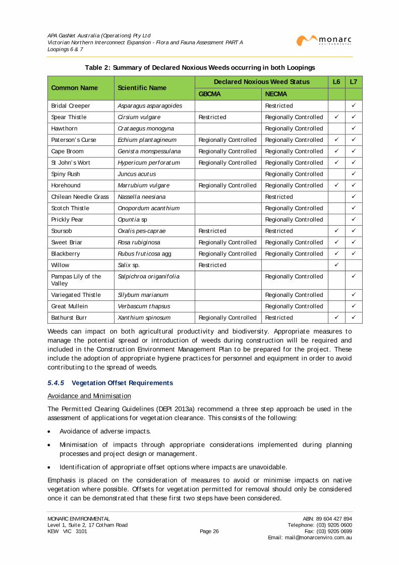
APA GasNet Australia (Operations) Pty Ltd Victorian Northern Interconnect Expansion - Flora and Fauna Assessment PART A Loopings 6 & 7
Table 2: Summary of Declared Noxious Weeds occurring in both Loopings
Common Name Scientific Name Declared Noxious Weed Status L6 L7
GBCMA NECMA
Bridal Creeper Asparagus asparagoides Restricted
Spear Thistle Cirsium vulgare Restricted Regionally Controlled
Hawthorn Crataegus monogyna Regionally Controlled
Paterson’s Curse Echium plantagineum Regionally Controlled Regionally Controlled
Cape Broom Genista monspessulana Regionally Controlled Regionally Controlled
St John’s Wort Hypericum perforatum Regionally Controlled Regionally Controlled
Spiny Rush Juncus acutus Regionally Controlled
Horehound Marrubium vulgare Regionally Controlled Regionally Controlled
Chilean Needle Grass Nassella neesiana Restricted
Scotch Thistle Onopordum acanthium Regionally Controlled
Prickly Pear Opuntia sp Regionally Controlled
Soursob Oxalis pes-caprae Restricted Restricted
Sweet Briar Rosa rubiginosa Regionally Controlled Regionally Controlled
Blackberry Rubus fruticosa agg Regionally Controlled Regionally Controlled
Willow Salix sp. Restricted
Pampas Lily of the Valley
Salpichroa origanifolia Regionally Controlled
Variegated Thistle Silybum marianum Regionally Controlled
Great Mullein Verbascum thapsus Regionally Controlled
Bathurst Burr Xanthium spinosum Regionally Controlled Restricted
Weeds can impact on both agricultural productivity and biodiversity. Appropriate measures to manage the potential spread or introduction of weeds during construction will be required and included in the Construction Environment Management Plan to be prepared for the project. These include the adoption of appropriate hygiene practices for personnel and equipment in order to avoid contributing to the spread of weeds.
5.4.5 Vegetation Offset Requirements
Avoidance and Minimisation
The Permitted Clearing Guidelines (DEPI 2013a) recommend a three step approach be used in the assessment of applications for vegetation clearance. This consists of the following:
• Avoidance of adverse impacts.
• Minimisation of impacts through appropriate considerations implemented during planning processes and project design or management.
• Identification of appropriate offset options where impacts are unavoidable.
Emphasis is placed on the consideration of measures to avoid or minimise impacts on native vegetation where possible. Offsets for vegetation permitted for removal should only be considered once it can be demonstrated that these first two steps have been considered.
MONARC ENVIRONMENTAL ABN: 89 604 427 894 Level 1, Suite 2, 17 Cotham Road Telephone: (03) 9205 0600 KEW VIC 3101 Page 26 Fax: (03) 9205 0699
Email: [email protected]
APA GasNet Australia (Operations) Pty Ltd Victorian Northern Interconnect Expansion - Flora and Fauna Assessment PART A Loopings 6 & 7
The design of the route is constrained by the use of the existing easement. All construction is proposed to be confined as much as possible to the existing easement created in 1975. Measures to avoid or minimise impacts can therefore only be confined to techniques to be implemented within the construction ROW generally either through the narrowing of the construction ROW or, if feasible, other construction techniques such as drilling or boring.
Following the detailed vegetation assessments for each looping section, the construction ROW was inspected by the APA Project Manager together with a qualified and experienced ecologist from Monarc to identify where clearance of native vegetation (vegetation that qualifies as a remnant patch or scattered tree under the guidelines) could be avoided or minimised. Measures applied to each looping to minimize impacts to vegetation or habitat are provided in the relevant section for each looping.
The aim was to reduce, where possible, impacts to native vegetation, scattered trees, Large Old Trees in patches and any other sensitive areas that were identified during the detailed vegetation assessments. Where threatened species and or communities were identified, avoidance and minimisation measures were also considered.
Each inspection was undertaken with reference to maps and GIS tools which clearly identified the extent of mapped remnant native vegetation, scattered trees and any threatened flora and fauna species recorded that could be potentially be impacted by the proposed works.
Any additional construction space required to accommodate turning space for vehicles or equipment storage was also identified at this time and placed, as much as possible, in areas where native vegetation or habitat would not be impacted.
The area of native vegetation identified for removal was then recalculated on the basis of the advice from APA in terms of their ability to avoid impacts on native vegetation during construction. The initial assessment was therefore revised on the basis of this advice to provide the final assessment of impacts of the construction ROW on native vegetation.
An arboricultural assessment was undertaken on both looping projects to determine the impact of construction on large trees (trees >40cm DBH) identified for retention within or close to the construction ROW. Recommendations regarding the future management of trees identified for retention and details of tree protection distances and construction controls required to minimise impacts to trees during the works were also included in the reports (Tree Logic 2015a, 2015b). These reports included an evaluation of Tree Protection Zones as described in Australian Standard 4970-2009 Protection of trees on development sites (Standards Australia 2010).
Biodiversity Impact and Offset Requirements
The Permitted Clearing Guidelines require that any application to remove native vegetation must consider the biodiversity impacts from the removal of this vegetation. Two types of offset requirements to reflect significance of impact have been identified under the Permitted Clearing Guidelines:
• General offset: for impacts deemed to be low or not significant, offsets focused on securing high value biodiversity assets.
• Specific offset: for significant impact on threatened species habitat, offsets need to specially compensate for that impact.
As part of the Permitted Clearing Guidelines, DELWP has produced models for Victoria describing the extent of habitat for each listed rare or threatened species. These models are called 'habitat
MONARC ENVIRONMENTAL ABN: 89 604 427 894 Level 1, Suite 2, 17 Cotham Road Telephone: (03) 9205 0600 KEW VIC 3101 Page 27 Fax: (03) 9205 0699
Email: [email protected]
APA GasNet Australia (Operations) Pty Ltd Victorian Northern Interconnect Expansion - Flora and Fauna Assessment PART A Loopings 6 & 7
importance models' and assign a 'habitat importance score' to a location based on the importance of that location in the landscape as habitat for a particular rare or threatened species (DEPI 2013a).
Under the Guidelines, these models form the basis for determining the impact of potential native vegetation clearing on rare and threatened species. The habitat importance scores are used to calculate the type and extent of biodiversity offsets required for native vegetation removal that impacts on individual rare or threatened species habitat.
Vegetation quality assessment data for each looping section was submitted to DELWP following finalisation and confirmation of all avoidance and minimisation measures. DELWP have generated a BIOR Report for each looping which provides the following information:
• Confirmation of the risk-based pathway that applies to the native vegetation identified for removal. The risk-based pathway is determined by combining the extent risk and the location risk of the native vegetation proposed to be removed in accordance with Section 6 of the ‘Permitted clearing of native vegetation – Biodiversity assessment guidelines’ (DEPI 2013a).
• The strategic biodiversity score of the native vegetation to be removed. This is a measure of the site’s importance to Victoria’s biodiversity relative to other locations across the landscape.
• Information to inform the assessment of whether the proposed removal of native vegetation will have a significant impact on Victoria’s biodiversity with specific regard to the proportional impact on habitat for any rare or threatened species. This is known as the specific-general offset test. The test determines if the proposed removal of native vegetation has a proportional impact on any rare or threatened species habitats above the specific offset threshold. According to DELWP the threshold is set at 0.005% of the total habitat for a species. When the proportional impact is above the specific offset threshold, a specific offset for that species’ habitat is required.
• The offset requirements applicable to the native vegetation proposed for removal. These are expressed in terms of ‘Biodiversity equivalence units’ which are based on:
o The habitat hectare score for each patch.
o An assessment of the importance of the patch to Victoria’s overall biodiversity (the strategic biodiversity score).
OR
In the event that the patch is considered to provide habitat for a threatened species (as mapped by DELWP), an assessment of the contribution of that patch to the habitat of the species (the habitat importance score).
This BIOR report provides the final offset obligations including the attributes that a proposed offset site must have to meet the requisite obligations for clearance (such as the minimum strategic biodiversity score or provision of habitat for a particular species).
Note that under the guidelines, an offset must be secured before native vegetation is removed. This could be either:
• A security agreement for the offset site that includes an onsite management plan.
• Evidence of a secured third party offset such as an allocated credit register extract from the native vegetation credit register.
MONARC ENVIRONMENTAL ABN: 89 604 427 894 Level 1, Suite 2, 17 Cotham Road Telephone: (03) 9205 0600 KEW VIC 3101 Page 28 Fax: (03) 9205 0699
Email: [email protected]
APA GasNet Australia (Operations) Pty Ltd Victorian Northern Interconnect Expansion - Flora and Fauna Assessment PART A Loopings 6 & 7
5.5 Threatened Species Assessment - Determining Significance
5.5.1 Species Status
All flora and fauna species records for the assessment area obtained during the literature and database review (refer Section 5.1) were evaluated to determine those species of significance that may occur within habitat intersected by the construction ROW.
The significance of a species or community was determined by reference to its listing under Commonwealth and/or State legislation. The sources used to categorise significance of species and communities in this report are summarised in Table 3.
Table 3: Characteristics that Determine Species Significance
Legislation Species / Community Significance
Commonwealth Listed as critically endangered, endangered, vulnerable or conservation dependant under the EPBC Act. Also species listed under various international agreements.
State
Listed as threatened or nominated under the FFG Act. Fauna listed as critically endangered, endangered or vulnerable on the DELWP Advisory List (DSE, 2013). Flora listed as endangered or vulnerable on the DELWP Advisory List (DEPI, 2014d). Invertebrates listed as critically endangered, endangered or vulnerable on the DELWP Advisory List (DSE, 2009).
Species found to fit the criteria provided in Table 3 were subsequently assessed for their potential to occur within habitat contained in the prospective construction ROW.
5.5.2 Likelihood of Occurrence
Habitat requirements of significant flora and fauna species previously recorded within 5km of the construction ROW, or that may potentially occur within the construction ROW, were assessed to determine their likelihood of occurrence within the construction ROW. The likelihood of a species occurring within the construction ROW was then ranked as Negligible, Low, Moderate or High.
Only those species listed under the EPBC Act, listed under the FFG Act or considered endangered or vulnerable on the DELWP Advisory Lists (DEPI 2014d; DSE 2013; DSE 2009) were assessed to determine their likelihood of occurrence. Descriptions of criteria utilised by Monarc to rank the likelihood of occurrence of flora and fauna within the construction ROW are summarised in Table 4 and Table 5.
MONARC ENVIRONMENTAL ABN: 89 604 427 894 Level 1, Suite 2, 17 Cotham Road Telephone: (03) 9205 0600 KEW VIC 3101 Page 29 Fax: (03) 9205 0699
Email: [email protected]
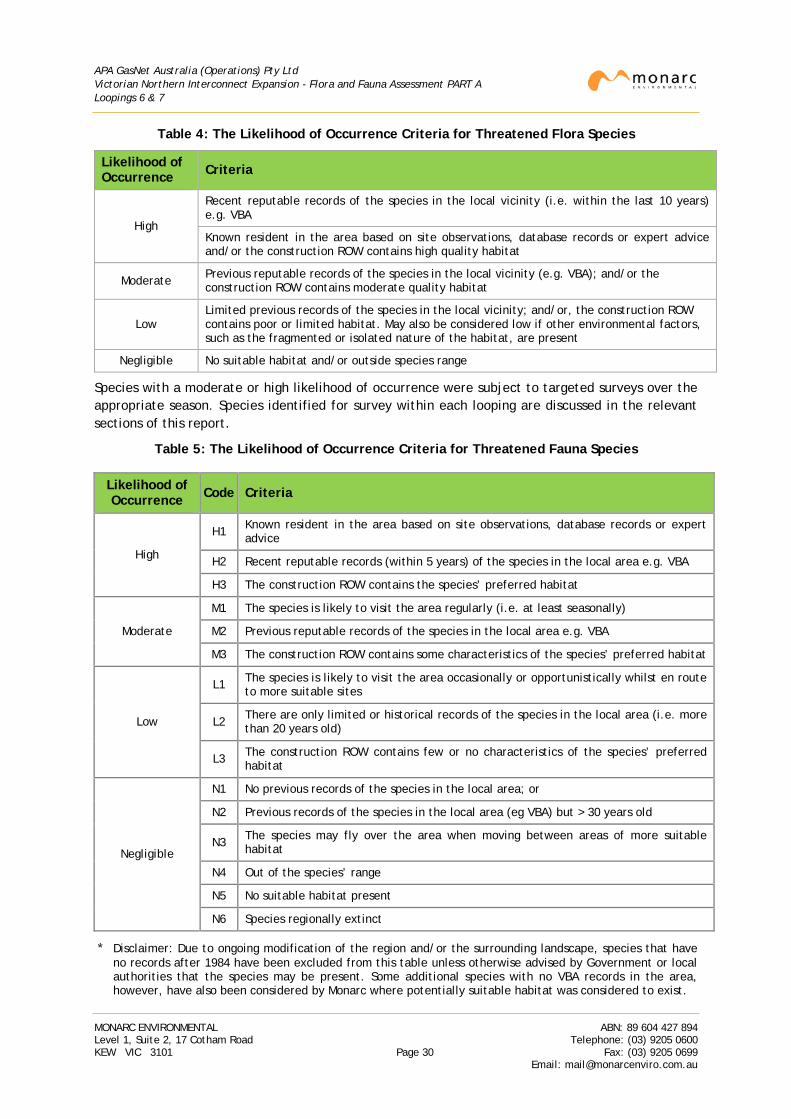
APA GasNet Australia (Operations) Pty Ltd Victorian Northern Interconnect Expansion - Flora and Fauna Assessment PART A Loopings 6 & 7
Table 4: The Likelihood of Occurrence Criteria for Threatened Flora Species
Likelihood of Occurrence Criteria
High
Recent reputable records of the species in the local vicinity (i.e. within the last 10 years) e.g. VBA
Known resident in the area based on site observations, database records or expert advice and/or the construction ROW contains high quality habitat
Moderate Previous reputable records of the species in the local vicinity (e.g. VBA); and/or the construction ROW contains moderate quality habitat
Low Limited previous records of the species in the local vicinity; and/or, the construction ROW contains poor or limited habitat. May also be considered low if other environmental factors, such as the fragmented or isolated nature of the habitat, are present
Negligible No suitable habitat and/or outside species range
Species with a moderate or high likelihood of occurrence were subject to targeted surveys over the appropriate season. Species identified for survey within each looping are discussed in the relevant sections of this report.
Table 5: The Likelihood of Occurrence Criteria for Threatened Fauna Species
* Disclaimer: Due to ongoing modification of the region and/or the surrounding landscape, species that have no records after 1984 have been excluded from this table unless otherwise advised by Government or local authorities that the species may be present. Some additional species with no VBA records in the area, however, have also been considered by Monarc where potentially suitable habitat was considered to exist.
Likelihood of Occurrence Code Criteria
High
H1 Known resident in the area based on site observations, database records or expert advice
H2 Recent reputable records (within 5 years) of the species in the local area e.g. VBA
H3 The construction ROW contains the species’ preferred habitat
Moderate
M1 The species is likely to visit the area regularly (i.e. at least seasonally)
M2 Previous reputable records of the species in the local area e.g. VBA
M3 The construction ROW contains some characteristics of the species’ preferred habitat
Low
L1 The species is likely to visit the area occasionally or opportunistically whilst en route to more suitable sites
L2 There are only limited or historical records of the species in the local area (i.e. more than 20 years old)
L3 The construction ROW contains few or no characteristics of the species’ preferred habitat
Negligible
N1 No previous records of the species in the local area; or
N2 Previous records of the species in the local area (eg VBA) but > 30 years old
N3 The species may fly over the area when moving between areas of more suitable habitat
N4 Out of the species’ range
N5 No suitable habitat present
N6 Species regionally extinct
MONARC ENVIRONMENTAL ABN: 89 604 427 894 Level 1, Suite 2, 17 Cotham Road Telephone: (03) 9205 0600 KEW VIC 3101 Page 30 Fax: (03) 9205 0699
Email: [email protected]
APA GasNet Australia (Operations) Pty Ltd Victorian Northern Interconnect Expansion - Flora and Fauna Assessment PART A Loopings 6 & 7
5.6 Threatened Species Assessment - Flora
5.6.1 Flora Species Profile
Threatened flora species targeted for survey were determined by reviewing the following:
• Habitat quality and types identified during the preliminary assessments.
• A review of the VBA data base for species recorded in the area.
• A review of the PMST for Matters of National Environment Significance listed under the EPBC Act.
• Undertaking an assessment of the species identified for their likelihood to occur in the area traversed by each looping (refer Section 5.5).
A breakdown of all flora species targeted (with the exception of species listed as ‘poorly known’ as per the DELWP Advisory List (DEPI 2014d), species description, habitat preference and flowering time are provided in Parts B and C. This includes an assessment of the likelihood of occurrence of each species, potential habitat, KP location and dates of surveys.
As a result, the following flora species, or groups of flora species were identified for survey:
• Winter flowering species within Looping 6.
• Winter flowering, threatened orchid species within Looping 7.
• Spring flowering species within Loopings 6 and 7.
• Early summer flowering species within Loopings 6 and 7.
Methodologies adopted to complete the required surveys are discussed below.
5.6.2 Survey Methodologies
Experienced field botanists and ecologists from Monarc conducted transects through all areas of vegetation considered to provide habitat for threatened flora species.
Targeted surveys focused on likely habitat within all areas which were systematically traversed in search of all threatened species identified. Where a listed species was located, the following information was recorded:
• The name, location and population size (or extent).
• Counts of the entire population if possible, or estimates of this from samples of the population.
• Age structure of the population if possible including any evidence of a viable reproducing population.
• Condition of the population if possible and any potential threats.
• Any distinguishing or unusual features of the population including differentiation or evidence of hybridisation and introgression.
The methodology applied was in accordance with significant impact guidelines and recommendations, where available, and in accordance with any of the survey guidelines contained within the Species Profile and Threats (SPRAT) Database maintained by DoE (including use if reference sites, where required).
MONARC ENVIRONMENTAL ABN: 89 604 427 894 Level 1, Suite 2, 17 Cotham Road Telephone: (03) 9205 0600 KEW VIC 3101 Page 31 Fax: (03) 9205 0699
Email: [email protected]
APA GasNet Australia (Operations) Pty Ltd Victorian Northern Interconnect Expansion - Flora and Fauna Assessment PART A Loopings 6 & 7
Surveys for Spiny Rice-flower and threatened orchid species were undertaken in accordance with the ‘Significant impact guidelines for the critically endangered spiny rice flower (Pimelea spinescens subsp. spinescens)’ and ‘Survey Guidelines for Australia’s threatened Orchids’ (CoA 2009; CoA 2013) respectively.
All surveys of the construction ROW were undertaken during the optimal flowering period for all targeted species. Due to differing flowering times of the targeted species, and species expected within each looping, surveys were undertaken over the following periods:
• Surveys for Looping 7 covered the period between October to November 2013 and June 2014.
• Surveys for Looping 6 were undertaken in August 2013 and between October to November 2013.
Survey locations for targeted surveys were selected based on the following:
• All remnant patches which were assessed as having an understorey Vegetation Quality Score of 15 and above via the Habitat Hectare methodology.
• All remnant patches wherein a part of the patch was permanently or ephemerally wet, incorporating a water-course, billabong or wetland etc.
All flora identified during the surveys was recorded irrespective of status. Results of the surveys are included in Parts B and C.
Note that the construction ROW forms a slim linear study area that may intersect only small portions of much larger areas of habitat. The focus of the study was on the ecological value of the construction ROW but in some cases (where potential habitat exists) the area examined was widened to assist in assessing the potential for the presence of certain species within habitat intersected by the construction ROW.
Common and scientific names used for flora within this report follow those used within the VBA maintained by DELWP.
5.7 Threatened Vegetation Communities
The majority of the pipeline is to be installed via trenching which requires clearance of vegetation over the construction ROW prior to construction. In addition to regulatory obligations (such as vegetation offsets) that may apply to the proposed works should approval for clearance of native vegetation be obtained, there is potential for the construction ROW to be occupied by vegetation communities that are listed under Commonwealth or State legislation. The PMST and the VBA was reviewed to determine if any threatened communities occur or are likely to occur within the study area for each looping section.
All vegetation was assessed against either the condition thresholds or the listing advice that is provided for each community and was assessed concurrently with the habitat hectare assessments. Brief descriptions of the communities that are likely and/or may occur within the area intersected by the project are listed and described below. The likelihood of occurrence of each community within each looping section is summarised in Parts B and C.
5.7.1 EPBC Act Listed Threatened Communities
Four EPBC Act listed communities have potential to occur along the construction ROW:
• Buloke Woodlands of the Riverina and Murray-Darling Depression Bioregions
MONARC ENVIRONMENTAL ABN: 89 604 427 894 Level 1, Suite 2, 17 Cotham Road Telephone: (03) 9205 0600 KEW VIC 3101 Page 32 Fax: (03) 9205 0699
Email: [email protected]
APA GasNet Australia (Operations) Pty Ltd Victorian Northern Interconnect Expansion - Flora and Fauna Assessment PART A Loopings 6 & 7
‘Buloke Woodlands of the Riverina and Murray Darling Depression Bioregion’ encompasses a number of closely-related woodland communities in which Buloke (Allocasuarina luehmannii) is usually the dominant or co-dominant tree. Other trees that may be prominent in the community are Slender Pine (Callitris gracilis), White/Murray Pine (Callitris glaucophylla), Black Box (Eucalyptus largiflorens), Yellow/Blue Gum (Eucalyptus leucoxylon subsp. pruinosa) and Grey Box (Eucalyptus microcarpa) (Cheal et al 2011).
The ground layer is usually grassy but can also include many subshrubs and herbs. While the composition of the ground stratum varies considerably, native grasses often include Wallaby Grasses (Rytidosperma spp.) and Spear Grasses (Austrostipa spp). Native shrubs and herbs may include Nodding Saltbush (Einadia nutans), Variable Groundsel (Senecio pinnatifolius), Variable Sida (Sida corrugata), New Holland daisies (Vittadinia spp.), Grassy Bindweed (Convolvulus remotus) and Wingless Bluebush (Maireana enchylaenioides) (Cheal et al 2011).
The community once occurred in a mosaic pattern across the northern parts of the Riverina interspersed amongst grasslands and eucalypt woodlands (although not in areas immediately adjacent to major rivers). Distribution appears to be influenced by a number of factors including rainfall, soil type and frequency of fire events. In Victoria, the community largely occurs in north–western Victoria but may be found in parts of northern central Victoria. Modelling of the community by DoE indicates that Looping 6 lies well south of where the community is likely to occur while Looping 7 is likely to lie just outside the south-eastern limit of where the community is likely to occur (although the northern part of may intrude). While such mapping is indicative only, in general, the community tends to be located in semi-arid areas to the north and west of project area and it is therefore not expected that the project will impact on this community.
• Grey Box (Eucalyptus microcarpa) Grassy Woodlands and Derived Native Grasslands of South-eastern Australia
Grey Box Grassy Woodlands generally occur in landscapes of low-relief such as flat to undulating plains, low slopes and rises and, to a lesser extent, drainage depressions and flats. It occurs both in a grassy woodland form with a tree canopy that is dominated or co-dominated by Grey Box (Eucalyptus microcarpa) and as a derived native grassland where the tree canopy and mid layer has been almost entirely removed but the native ground layer remains largely intact (DSEWPaC 2012b). In the woodland form, the understorey contains a moderately dense to sparse shrub layer and a ground layer of perennial and annual native forbs and graminoids.
The community predominantly occurs on the drier edge of the temperate grassy eucalypt woodland belt that covered the lower slopes and plains of mainland eastern Australia, inland of the Great Dividing Range, and which ranges from central New South Wales through northern and central Victoria into South Australia. An indicative map of where the community is likely to occur (refer DSEWPaC 2012b) indicates that Looping 6 lies on the southern edge of its likely range, while Looping 7 lies almost entirely within the south-eastern boundary. Therefore both loopings have the potential to intersect remnants of the community although it is more likely to be present in areas around Looping 7.
• ‘Natural Grasslands of the Murray Valley Plains’
‘Natural Grasslands of the Murray Valley Plains’ is a type of natural temperate grassland that has semi-arid characteristics, due to the lower rainfall where it occurs.
Modelling of the distribution of the community by DoE (2015b) suggests that Loopings 6 and 7 lie outside of the area in which the community may occur, that is, approximately Avenel to
MONARC ENVIRONMENTAL ABN: 89 604 427 894 Level 1, Suite 2, 17 Cotham Road Telephone: (03) 9205 0600 KEW VIC 3101 Page 33 Fax: (03) 9205 0699
Email: [email protected]
APA GasNet Australia (Operations) Pty Ltd Victorian Northern Interconnect Expansion - Flora and Fauna Assessment PART A Loopings 6 & 7
Benalla. In Victoria, a substantial part of the ecological community is recognised as ‘Northern Plains Grasslands’, which is listed as threatened under the Victorian FFG Act. This generally occurs within semi-arid area to the west and north-west of the project area and it is not expected that this community will be impacted by the project.
• White Box-Yellow Box-Blakely's Red Gum Grassy Woodland and Derived Native Grassland
The listed community can occur either as woodland or grassland from which the trees have been removed. It has a ground layer dominated by native tussock grasses and herbs (that is, greater than 50%) and a sparse, scattered shrub layer (less than 30%). White Box (Eucalyptus albens), Yellow Box (E. melliodora) or Blakely’s Red Gum (E. blakelyi) dominate the community where a tree layer still occurs (DEH 2006a).
In Victoria, the community tends to occur on the slopes and tablelands on the northern side of the Great Dividing Range. The EVCs that may correspond to this community include Valley Grassy Forest (EVC 47) and Grassy Woodland (EVC 175).
The potential EPBC Act listed communities identified for assessment within the construction ROW were therefore:
• Buloke Woodlands of the Riverina and Murray-Darling Depression Bioregions
• Grey Box (Eucalyptus microcarpa) Grassy Woodlands and Derived Native Grasslands of South-eastern Australia
• White Box-Yellow Box-Blakely's Red Gum Grassy Woodland and Derived Native Grassland
The construction ROW was assessed according to the thresholds provided in the relevant Policy document. Where vegetation within the construction ROW was determined to correspond to the listed community, the area of impact within the construction ROW was will be assessed by comparison with the extent of the whole patch contiguous with the construction ROW, but lying outside the construction ROW, once the project footprint has been finalized.
5.7.2 FFG Act Listed Threatened Communities
Three FFG Act listed communities were identified with the potential to occur along the construction ROW in either or both loopings. These are:
• Creekline Grassy Woodland (Goldfields) Community
The Creekline Grassy Woodland (Goldfields) Community occurs along shallow or ephemeral drainage lines as small remnants within the box-ironbark ecosystems of Victoria (DEPI 2013b). It is distinct from the riparian vegetation found along permanently flowing streams on the alluvial plains.
The overstorey tends to be dominated by River Red Gum (Eucalyptus camaldulensis), but may occasionally include Yellow Box (E. melliodora) and Grey Box (E. microcarpa), with a dense understorey of native grasses and sedges.
Modelling of listed communities across Victoria by DELWP indicates that Loopings 6 and 7 pass through areas where scattered patches of the community are potentially present (DEPI 2014c). In the area of the construction ROW, DELWP modelling of the potential occurrence of the community has been largely linked to the modelling of EVC 68 Creekline Grassy Woodland. This suggests that all remnant patches that qualify as EVC 68 could potentially correspond to the community. However, the FFG Act listed community is described as containing a dense understorey of native grasses and sedges and therefore only those woodland areas adjoining
MONARC ENVIRONMENTAL ABN: 89 604 427 894 Level 1, Suite 2, 17 Cotham Road Telephone: (03) 9205 0600 KEW VIC 3101 Page 34 Fax: (03) 9205 0699
Email: [email protected]
APA GasNet Australia (Operations) Pty Ltd Victorian Northern Interconnect Expansion - Flora and Fauna Assessment PART A Loopings 6 & 7
ephemeral drainage lines with a dominant native understorey have been categorised as the FFG Act community.
• Grey Box - Buloke Grassy Woodland Community
The Grey Box - Buloke Grassy Woodland Community is a mainly grassy woodland found on flat or very gently undulating plains in northern Victoria and a few places in central Victoria (DEPI 2013b). It tends to develop in the absence of fire on sites with relatively fertile, fine-grained soils.
The tree layer is usually dominated by Grey Box (Eucalyptus microcarpa) over a lower stratum of Buloke (Allocasuarina luehmannii) although Buloke may become the dominant species when fire is absent over a long period. The ground layer is generally dominated by grasses such as Bristly Wallaby-grass (Rytidosperma setaceum), Windmill-grass (Chloris truncata), Common Wheat-grass (Elymus scaber) and occasionally Kangaroo Grass (Themeda triandra). While shrubs are generally absent, wattles such as Deane’s Wattle (Acacia deanei), Gold-dust Wattle (A. acinacea) and Golden Wattle (A. pycnantha) may be present at some sites together with a few other shrubs such as Drooping Cassinia (Cassinia arcuata).
The FFG Act listed community is closely related to the EPBC Act listed ‘Grey Box Grassy Woodland’ discussed above. Modelling of listed communities across Victoria by DELWP indicates that Loopings 6 and 7 pass through areas where scattered patches of the community are potentially present (DEPI 2014c).
In the area of the construction ROW, DELWP modelling of the potential occurrence of the community has been largely linked to the modelling of EVC 55. This suggests that all remnant patches that qualify as EVC 55_61 and EVC 55_62 Plains Grassy Woodland could potentially correspond to the community. However, the FFG Act listed community is described as containing a lower stratum of Buloke with a ground layer containing predominantly native grasses and, occasionally, a scattering of acacia and a few other shrubs (DEPI 2013b). Therefore, in absence of threshold criteria, when determining the occurrence of this community within the construction ROW, only those remnant patches with Buloke and a mainly native ground layer have been categorised as the FFG Act community. As the construction ROW is relatively narrow (and may not therefore contain a Buloke), this included consideration of whether the vegetation in the immediate vicinity of the construction ROW (that is of the same vegetation type) could be reasonably considered to contain these characteristics e.g. Bulokes were observed adjacent to the construction ROW.
• Northern Plains Grassland
The Northern Plains Grassland Community is restricted to the naturally treeless plains of northern Victoria, and is dominated by largely perennial tussocky grasses and an occasional, sparse occurrence of trees or large shrubs (DEPI 2013b). The community is readily distinguished from other grasslands and grassy woodlands in Victoria by the absence of Themeda triandra.
Modelling of listed communities across Victoria by DELWP indicates that this community occurs in similar locales to the Grey Box-Buloke Grassy Woodland Community. This appears largely to be a result of the matching of the community to one or more EVCs (in this case EVC 55). A description of the community provided by the FFG Act Scientific Advisory Committee, however, indicates that the community extends from Echuca in the east to the Patho Plains near the Loddon River in the west (DEPI 2013b), an area which lies about 100km north-west of Looping 6 and approximately 200km west of Looping 7. The community is therefore not expected to be impacted by the project.
MONARC ENVIRONMENTAL ABN: 89 604 427 894 Level 1, Suite 2, 17 Cotham Road Telephone: (03) 9205 0600 KEW VIC 3101 Page 35 Fax: (03) 9205 0699
Email: [email protected]
APA GasNet Australia (Operations) Pty Ltd Victorian Northern Interconnect Expansion - Flora and Fauna Assessment PART A Loopings 6 & 7
The potential FFG Act listed communities identified for assessment within the construction ROW were therefore:
• Creekline Grassy Woodland (Goldfields) Community
• Grey Box - Buloke Grassy Woodland Community
5.8 Threatened Species Assessment - Fauna
Threatened fauna species targeted for survey were determined by reviewing the following:
• Habitat quality and types identified during the preliminary assessments.
• A review of the VBA database for species recorded in the area.
• A review of the PMST for Matters of National Environment Significance listed under the EPBC Act.
• Undertaking an assessment of the species identified for their likelihood to occur in the area traversed by each looping (refer Section 5.5).
In forming conclusions on the likelihood of a species occurrence in the area and the potential impact from construction, the following general considerations were taken into account (other species specific considerations may apply): areas devoid of remnant native vegetation, such as agricultural paddocks, are generally considered to have few if any ecological values and are usually of negligible significance for threatened native fauna. Species richness or diversity is relatively limited within these areas.
A breakdown of all threatened fauna species targeted and their descriptions are provided in Parts B and C. This includes an assessment of the likelihood of occurrence of each species, their preferred habitat, and latest recorded dates.
As a result, the following fauna species were identified for survey:
• Golden Sun Moth within Looping 6.
• Striped Legless Lizard within Looping 6.
• Amphibian species being Growling Grass Frog and Brown Toadlet (Loopings 6 and 7).
• Commonwealth significant birds such as Regent Honeyeater, Painted Honeyeater and Swift Parrot (Looping 7).
• State significant bird species such as Barking Owl and Grey-crowned Babbler (Loopings 6 and 7).
• State significant mammal species such as Brush-tailed Phascogale and Squirrel Glider (Loopings 6 and 7).
• Aquatic vertebrate and invertebrate species occupying larger waterways intersected by the construction ROW (Loopings 6 and 7).
Surveys of Looping 6 and 7 for threatened fauna species were undertaken at various times across the year depending on the fauna species being surveyed, these were:
o Golden Sun Moth during December 2013 to January 2014.
o Brown Toadlet was surveyed during autumn 2015.
o Surveys for birds, mammals and reptiles were conducted across the project area from November 2013 to January 2014.
MONARC ENVIRONMENTAL ABN: 89 604 427 894 Level 1, Suite 2, 17 Cotham Road Telephone: (03) 9205 0600 KEW VIC 3101 Page 36 Fax: (03) 9205 0699
Email: [email protected]
APA GasNet Australia (Operations) Pty Ltd Victorian Northern Interconnect Expansion - Flora and Fauna Assessment PART A Loopings 6 & 7
o Growling Grass Frog were conducted across the project area from November to December 2013
to January 2014.
o Surveys for Regent Honeyeater and Swift Parrot were undertaken in July 2014.
o Aquatic surveys of the larger creeks and rivers were carried out in November 2014.
o Striped Legless Lizard surveys were conducted during winter 2015, following discussions with DELWP staff.
All surveys were undertaken in accordance with Commonwealth or State guidelines, where available, and included consideration of survey timing and survey effort (e.g. number and length of surveys required for each targeted species). Survey effort was also discussed with regulatory authorities and other professionals where available records were limited.
Chiltern - Mt. Pilot National Park is regarded as important habitat for many threatened species such as Squirrel Glider, Regent and Painted Honeyeaters (Parks Victoria, 2008). Therefore, presence of threatened species has been assumed in the park and was not surveyed during the spring fauna surveys. Winter surveys for Regent Honeyeaters and Swift parrots were undertaken in the park along the pipeline alignment.
All fauna identified during the surveys were recorded irrespective of their status. Methodologies applicable to each survey type are discussed below. The results of surveys are discussed in Parts B and C.
5.8.1 Golden Sun Moth
Targeted surveys for Golden Sun Moths (GSM) were undertaken by experienced field ecologists from Monarc between 31 December 2013 and 30 January 2014.
Two locations within Looping 6 were identified for survey due to their vegetation composition and proximity to known GSM populations at Mt. Piper Nature Conservation Reserve, west of Broadford and Whiteheads Creek, east of Seymour. A summary of fauna survey effort and locations is provided in Part B.
Surveys were undertaken on warm and relatively cloudless days over 20 degrees Celsius (by 1000hrs) with little to no wind and at least two days after rain as per the recommendations contained in Commonwealth and State guidelines (refer DEWHA 2009a). Each survey site was assessed over four suitable days, at approximately weekly intervals, depending on suitable weather conditions. Due to the later start of the 2013 flying season for GSM, the Port Phillip Region of DEPI extended the survey season until the end of February 2014 (Winfield 20131, pers. comm.). After discussions with Hume Region of DEPI, this extension was also approved for the sites surveyed as part of this project.
Surveys were limited to the existing 35m wide pipeline easement and were undertaken by two ecologists walking in transect lines spaced approximately five metres apart. The surveys included traversal of the pipeline easement multiple times between 1000hrs and 1600hrs on all survey days. Surveyors were searching for flying males, laying females and/or signs of eggs or pupal cases to confirm signs of reproduction.
Habitat features of each survey location, such as vegetation composition and structure and presence of bare ground and inter-tussock spaces were noted. If Golden Sun Moth sightings, then GPS location was to be recorded and photos taken where possible.
1Email from Mark Winfield, Environment and Water Regional Manager, Port Phillip Region DEPI to GSM Network 23/12/2013 with follow up email on 30/1/2014
MONARC ENVIRONMENTAL ABN: 89 604 427 894 Level 1, Suite 2, 17 Cotham Road Telephone: (03) 9205 0600 KEW VIC 3101 Page 37 Fax: (03) 9205 0699
Email: [email protected]
APA GasNet Australia (Operations) Pty Ltd Victorian Northern Interconnect Expansion - Flora and Fauna Assessment PART A Loopings 6 & 7
In accordance with survey guidelines for the species, reference sites were surveyed on the same day as all project surveys to confirm the species was flying during the survey period. Mt. Piper Nature Conservation Reserve, near Broadford, was recommended as the primary reference site due to its proximity to the construction ROW (approximately 6km west) and confirmed GSM population (Smith 2013, pers. comm.). However, no GSM were recorded from the Mt. Piper reference site during any of the four surveys. Secondary sites, further south of the easement, were therefore also sourced from the ‘GSM Network’ administered by Biosis for the days that surveys were conducted.
5.8.2 Growling Grass Frog
Targeted surveys for Growling Grass Frogs were undertaken by experienced field zoologists and ecologists from Monarc between mid-December 2013 and the end of January 2014. A summary of fauna survey effort is provided in Parts B and C.
Surveys were conducted in accordance with Commonwealth guidelines (DEWHA 2009b) and included the following:
• Survey nights were selected on the basis of projected weather conditions which included fine conditions (day-time temperatures above 15 degrees Celsius and minimum night-time temperatures above 12 degrees Celsius) and little or no wind;
• Surveys were conducted between 2100hrs and 0300 hrs on the days indicated using a combination of active searching with spotlights in appropriate habitat, call recording and call playback (using the advertising call of the male) and a search of banks and emergent vegetation where appropriate.
Surveys commenced with a period of listening at each survey point to determine if any frogs were active in the area (minimum 10 minutes). Males are likely to respond to playback during the breeding season and therefore calls were broadcast at a number of locations along the targeted waterways (maximum of 50m spacing) and at least two locations within each of the smaller water bodies. After playback ten minutes was spent listening for any evidence of Growling Grass Frog response. All frogs audible during the survey were recorded for later confirmation against reference recordings of frog calls and all species detected during the surveys were noted.
Habitat features such as vegetation composition and structure, presence of refuge or shelter sites and suitable dispersal sites were also noted. Features noted about each of the survey sites included availability of breeding habitat (e.g. suitable vegetation) and location in the landscape (e.g. proximity to other possible Growling Grass Frog sites).
A total of 13 locations across both loopings were identified for survey, however two sites were deemed unsuitable at the time of the first survey, due to being dry. All 11 sites were surveyed twice before the end of December 2013 to achieve a 95% probability of occupancy in accordance with Heard et al (2010). Refer to Parts B and C for further details.
Whilst no reference sites were identified in the immediate area during the survey, GGF activity has been recorded within 5km of the construction ROW as identified during the desktop assessment. The level of survey is therefore considered sufficient to maximise the probability of detecting adult GGF within the study area during this period.
5.8.3 Brown Toadlet
Targeted surveys for Brown Toadlet were undertaken across Loopings 6 and 7 during autumn 2015.
Breeding for the species generally occurs over autumn with male calling starting as early as February and continuing through to June. Surveys were therefore conducted by experienced field
MONARC ENVIRONMENTAL ABN: 89 604 427 894 Level 1, Suite 2, 17 Cotham Road Telephone: (03) 9205 0600 KEW VIC 3101 Page 38 Fax: (03) 9205 0699
Email: [email protected]
APA GasNet Australia (Operations) Pty Ltd Victorian Northern Interconnect Expansion - Flora and Fauna Assessment PART A Loopings 6 & 7
zoologists and ecologists from Monarc during April 2015 and included a combination of active searching with spotlights in appropriate habitat, call recording and call playback. Active searching includes a search of banks and emergent vegetation where appropriate.
A total of 12 locations across Loopings 6 and 7 were identified for survey. All sites were surveyed twice within the recommended seasonal period during moderate climatic conditions. Chiltern - Mt. Pilot National Park will not be surveyed, as per comments in section 5.8 above.
Howard et al (2010) states that “When conditions are suitable for calling, there is a greater than 90% chance of detecting calling within two minutes, and greater than 99% chance within four minutes”. The level of survey undertaken was therefore considered sufficient to maximise the probability of detecting adult Brown Toadlets within the survey area during this period. Further details of the surveys can be found in Parts B and C.
5.8.4 Striped Legless Lizard
Targeted winter surveys for SLL in Looping 6 were undertaken by two zoologists during daylight hours between 22 and 25 June 2015. Based on recommendations from Hume DELWP (Smith, 2014 pers. comm), the expertise of Mr. Bertram Lobert was sought to assist with undertaking an active winter search through potential habitat. Each zoologist walked transects approximately 10m apart and searched under rocks, logs, within grass tussocks and under discarded building materials. Surveyors ensured that all refugia were placed back in the same position, to reduce the level of disturbance to fauna habitat.
All vertebrate species observed during the surveys were recorded and a habitat assessment was conducted in areas where priority SLL habitat was identified and subsequently mapped as potential salvage sites.
5.8.5 Birds and Reptiles
Bird surveys were undertaken by experienced ornithologists and field ecologists from Monarc between mid-October 2013 and mid-January 2014 and again in winter (June to July) 2014. The easement was also surveyed for any reptiles at this time. A summary of fauna survey effort is provided in Parts B and C.
Survey methods were in accordance with methods set out in the Biodiversity Precinct Structure Planning Kit (DSE 2010a) and Survey guidelines for Australia’s threatened birds (DEWHA 2010). The spring-summer surveys were conducted twice at each site over two different time periods on separate days (early morning and early evening). Early morning surveys were undertaken between 0700hrs and 1100hrs and early evening surveys between 1600hrs and 2000hrs). The winter surveys were conducted on four separate occasions at each location.
Surveys were undertaken by two people walking along 100m transect lines for ten minutes either side or along the easement, a total of 30 minutes was spent at each site. This method is considered suitable for surveys on linear areas of Crown Land such as roadsides and waterways and was chosen following expert advice on methods appropriate to the habitat quality and extent intersected by the construction ROW (Loyn 2013 pers. comm.). Note that where the easement passed through private property, surveys were only undertaken on the easement due to limited access outside this area. However, any birds or other fauna observed within the vicinity were also recorded.
A total of 38 locations across both loopings were identified for survey, with 136 individual surveys being conducted. Binoculars were used to scan the area for birds and other evidence of avifauna such as nests. All species seen and heard within the 100m transect were recorded. This included presence of birds, reptiles and mammals. The GPS location of any threatened species located was
MONARC ENVIRONMENTAL ABN: 89 604 427 894 Level 1, Suite 2, 17 Cotham Road Telephone: (03) 9205 0600 KEW VIC 3101 Page 39 Fax: (03) 9205 0699
Email: [email protected]
APA GasNet Australia (Operations) Pty Ltd Victorian Northern Interconnect Expansion - Flora and Fauna Assessment PART A Loopings 6 & 7
recorded and photos taken where possible. GPS locations of nests and hollows that are in use were also noted.
5.8.6 Nocturnal Surveys
Nocturnal surveys for threatened mammal and avian species were undertaken by experienced zoologists and field ecologists from Monarc between late-November 2013 and mid-January 2014. A summary of fauna survey effort is provided in Parts B and C.
Surveys were conducted over two nights at each site between 2100hrs and 0200hrs. Surveys were undertaken by two people walking along 100m transect lines for ten minutes either side or along the easement. This method was chosen following discussions on appropriate methods given the nature and time frame for the surveys (Loyn 2013, pers. comm.). This method was suitable for surveys on Crown Land such as roadsides and waterways. However, due to limited access, on private property the surveys were limited to the easement. Any fauna observed or heard within the vicinity were also recorded.
A total of 35 locations across both loopings were identified for survey, with 70 individual surveys being conducted. Head torches and spot lights were used to scan the area for mammals and birds and observers searched trees for nests and hollows. Brief periods of call playback were also used to initiate a response from threatened nocturnal birds such as Barking Owl or Bush Stone-curlew. All species seen and heard within the 100m transect were recorded. This included presence of birds, mammals, amphibians and reptiles. The GPS location of any threatened species located was recorded and photos taken where possible.
5.8.7 Aquatic Surveys
A desktop assessment was undertaken to highlight the potential occurrence of threatened aquatic species within 10km of the larger waterway crossings.
Surveys of the larger waterways for threatened aquatic species were therefore undertaken in November 2014 for both Looping 6 and 7. Surveys were undertaken by GHD and the detailed methodology and results are set out in the Aquatic Fauna Survey report (GHD 2015) presented in Appendix B11.
Aquatic surveys were undertaken to determine the extent to which EPBC Act and FFG Act listed aquatic species are likely to occur within the vicinity of the crossings. Whilst threatened species have previously been recorded within some of the waterways to be surveyed, the survey effort has generally been low and the crossing areas have not previously been surveyed. These waterways have been chosen for survey as they are considered to be areas of higher sensitivity and are more likely to contain water at the time of construction than other waterways.
All perennial waterways intersected by the project that have potential to contain listed aquatic species and that have been identified for HDD were also surveyed as a contingency measure in the unlikely event that HDD methods are not successful.
Aquatic surveys were undertaken using a combination of dip-netting, fyke netting and electrofishing (back pack and boat-mounted). The following waterways were surveyed:
Looping 6 Dabyminga Creek (KP58.6)
Goulburn River (KP62.8)
Looping 7 Fifteen Mile Creek (KP125.7)
King River (KP135.1)
MONARC ENVIRONMENTAL ABN: 89 604 427 894 Level 1, Suite 2, 17 Cotham Road Telephone: (03) 9205 0600 KEW VIC 3101 Page 40 Fax: (03) 9205 0699
Email: [email protected]
APA GasNet Australia (Operations) Pty Ltd Victorian Northern Interconnect Expansion - Flora and Fauna Assessment PART A Loopings 6 & 7
Yanko Creek (KP137.3)
Ovens River (KP138.03)
Black Dog Creek (KP172.7)
Indigo Creek (KP183.38)
5.9 Threatened Fauna Communities
While the EPBC Act doesn’t list fauna communities as such, the FFG Act lists four fauna communities as threatened across the State.
5.9.1 FFG Act Listed Threatened Communities
Two FFG Act communities were identified with the potential to occur along the construction ROW in either or both loopings, based on their characteristics. These are:
• Lowland Riverine Fish Community of the southern Murray-Darling Basin
The Lowland Riverine Fish Community of the southern Murray-Darling Basin is characteristic of the geographical area that defines its distribution, and by a selected suite of native fish taxa that is typical of and largely restricted to the area.
The geographical area that delineates this fish assemblage can be broadly defined as the lowland river reaches and associated floodplains of the Murray River tributaries in Victoria that drain the northern slopes of the Great Dividing Range, together with the lowland section and floodplain of the Murray River upstream of the South Australian border. The major streams involved are: the Mitta Mitta, Ovens, Broken, Goulburn, Campaspe, Loddon and Avoca Rivers. Whilst this community mainly occurs in the lowland river reaches, some species may also occur (at least at certain times) in both the slope and upland river reaches (DEPI, 2013b).
The fish fauna is predominantly characterized by 15 native fish species of which the following 8 species have been identified as occurring within a 10km radius of the ROW, these are: Silver Perch Bidyanus bidyanus, Flat-headed Galaxias Galaxias rostratus, Western Carp Gudgeon Hypseleotris klunzingeri (now considered to be a species complex), Murray Cod Maccullochella peelii, previously Maccullochella peelii peelii, Golden Perch Macquaria ambigua, Macquarie Perch Macquaria australasica, Southern Purple-spotted Gudgeon Mogurnda adspersa and Flat-headed Gudgeon Philypnodon grandiceps.
Other widespread or uncommon species mentioned in the community characteristics that have also been recorded are: Southern Pigmy Perch Nannoperca australis, River Blackfish Gadopsis marmoratus, Two-spined Blackfish Gadopsis bispinosus, Australian Smelt Retropinna semoni, Short-headed Lamprey Mordacia mordax and Short-finned Eel Anguilla australis.
• Victorian Temperate Woodland Bird Community
The Victorian Temperate Woodland Bird Community is a group of bird species commonly found within box-ironbark, yellow box, cypress pine and other woodlands along the slopes and plains to the north of the Great Dividing Range.
The description of the community identifies twenty-four key indicator species that are characteristic of the listed community, a number of which are listed on the FFG Act (DEPI, 2013b). Some of the key indicator species listed as part of the community that are known to occur in the project area (that is, with records on the VBA) include Bush Stone-curlew, Brown Treecreeper Climacteris picumnus victoriae, Swift Parrot, Jacky Winter Microeca fascinans,
MONARC ENVIRONMENTAL ABN: 89 604 427 894 Level 1, Suite 2, 17 Cotham Road Telephone: (03) 9205 0600 KEW VIC 3101 Page 41 Fax: (03) 9205 0699
Email: [email protected]
APA GasNet Australia (Operations) Pty Ltd Victorian Northern Interconnect Expansion - Flora and Fauna Assessment PART A Loopings 6 & 7
Barking Owl Ninox connivens connivens, Grey-crowned Babbler, Regent Honeyeater Anthochaera phyrgia and Diamond Firetail Stagonopleura guttata.
The community therefore has the potential to occur within woodland intersected by Loopings 6 and 7. The community may also correlate with the national ecological communities known as ‘Grey Box Grassy Woodland’ and ‘White Box-Yellow Box-Blakely's Red Gum Grassy Woodland’ as well as the State-listed ‘Grey Box – Buloke Grassy Woodland Community’. Where such communities are found within the construction ROW, there is therefore the potential for the temperate woodland bird community to also occur.
Many of the remnant patches of native vegetation intersected by the construction ROW within Loopings 6 and 7 are likely to support some, or many, of the bird species that are listed under this community.
While no assessment criteria exists for the determination of a community presence, both of these potential FFG Act listed communities were identified as occurring within the construction ROW based on their characteristics including associated fauna species.
5.10 Survey Limitations
5.10.1 Flora
The methodology employed for this assessment (i.e. field survey combined with information available from other desktop information sources) is considered sufficient to determine if the project would have a significant impact on any threatened species, population or ecological community. No significant study limitations were identified. However, the following considerations apply:
• The surveys covered vascular flora only (ferns, conifers and flowering plants). Non-vascular flora (e.g. mosses, liverworts) were not considered.
• Surveys provide a sampling of flora at a given time only. Different seasonal conditions may provide more flora species. While every effort has been taken to identify the significant species that may be expected to occur in the area and, subsequently, to examine parts of the construction ROW at times appropriate to the flowering of the significant species identified, some other flora species may not have been visible due to dormancy (e.g. orchids or certain herbaceous species which leaf and flower during certain periods of the year but remain underground at other times) or their presence during the survey period as seeds only (e.g. annuals whose life cycle is completed within one season). Other plant species are perennial but are inconspicuous unless flowering. More plant species may have been recorded with additional surveys, however, the field surveys, which were undertaken at times when detection of most threatened species is high, combined with information available from other sources documented in this report is deemed appropriate to assess the ecological values of the construction ROW.
• Much of the construction ROW is subject either to intensive grazing by domestic stock animals or ploughing. This could lead to the removal of live plant material and/or fruiting materials and may restrict the ability to identify all the plants species that could be present within the construction ROW.
5.10.2 Native Vegetation
The construction ROW forms a slim linear project area that generally intersects only small portions of much larger areas of remnant vegetation. Much of the construction ROW passes through private
MONARC ENVIRONMENTAL ABN: 89 604 427 894 Level 1, Suite 2, 17 Cotham Road Telephone: (03) 9205 0600 KEW VIC 3101 Page 42 Fax: (03) 9205 0699
Email: [email protected]
APA GasNet Australia (Operations) Pty Ltd Victorian Northern Interconnect Expansion - Flora and Fauna Assessment PART A Loopings 6 & 7
land. The focus of the study was therefore on the ecological value of the construction ROW being the area accessible to APA. The quality of vegetation when assessed on a broader scale across a property may differ when compared to an assessment of a small portion of that area such as that intersected by the construction ROW.
Note also that threshold criteria provided for some listed vegetation communities such as White Box-Yellow Box-Blakely's Red Gum Grassy Woodland require patches to be assessed at a scale of 0.1ha or greater (DEH 2006a). In many cases, the area of vegetation intersected by the construction ROW was less than this figure. Assessment for the presence of this community was based entirely on vegetation found within the construction ROW.
Any judgment about the quality of vegetation outside the area of the construction ROW (for instance when assessing the impact of proposed works on patches of listed communities) is based on modelling of vegetation types by DELWP documented within the Biodiversity Information Management System (DEPI 2014h).
Field equipment used to map vegetation included hand held GPS devices. Accuracy of such equipment varies but is not guaranteed beyond about ±5m. As a result, there may be some differences between patches represented on mapping produced for this report and on ground conditions. This may also impact on whether scattered trees have been designated to be inside or outside the construction ROW.
5.10.3 Fauna
The methodology employed for this assessment (i.e. field survey combined with information available from desktop information sources) is considered sufficient to determine if the development will have a significant impact on any threatened species, population or ecological community. No significant study limitations were identified, however the following considerations apply:
• The construction ROW forms a slim linear project area that may intersect only small portions of much larger areas of habitat. Most of the construction ROW passes through private land. The focus of the study was therefore on the ecological value of the construction ROW being the area accessible to APA. In some cases (where potential habitat exists or access was available), the area examined was widened to assist in assessing the potential for the presence of certain species within habitat intersected by the construction ROW.
• While the surveys are considered adequate for detecting active fauna typical of the area, such surveys provide a sampling of the fauna only at a given time. Factors such as time of year and day, weather conditions, species behaviour and habitat impact on the likelihood of locating many species. The surveys were therefore undertaken, during times and conditions, when the targeted threatened species were considered most likely to be active and the chance of locating uncommon or transient species was highest. More species may have been recorded with additional surveys, however, the survey effort is deemed appropriate to provide a reasonable assessment of the ecological values of the project area.
• Active searching was recommended for Striped Legless Lizard outside of the breeding season,. For the reasons stated in Section 3.2.3 of Flora and Fauna Assessment PART B Broadford to Mangalore (KP45.2 to KP74.3) Looping 6, targeted surveys were not considered feasible for this project. Therefore, species’ presence is assumed in areas that were identified as priority habitat, or where historical records exist within close vicinity to the pipeline corridor.
MONARC ENVIRONMENTAL ABN: 89 604 427 894 Level 1, Suite 2, 17 Cotham Road Telephone: (03) 9205 0600 KEW VIC 3101 Page 43 Fax: (03) 9205 0699
Email: [email protected]
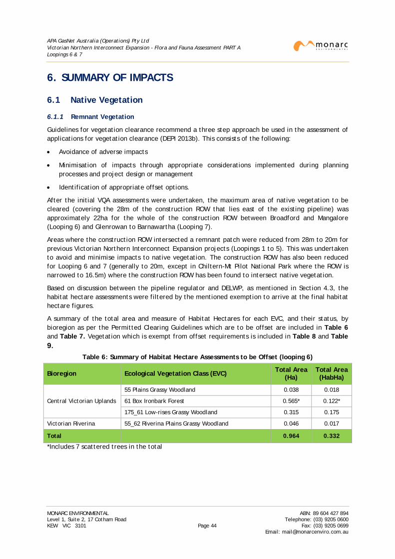
APA GasNet Australia (Operations) Pty Ltd Victorian Northern Interconnect Expansion - Flora and Fauna Assessment PART A Loopings 6 & 7
6. SUMMARY OF IMPACTS
6.1 Native Vegetation
6.1.1 Remnant Vegetation
Guidelines for vegetation clearance recommend a three step approach be used in the assessment of applications for vegetation clearance (DEPI 2013b). This consists of the following:
• Avoidance of adverse impacts
• Minimisation of impacts through appropriate considerations implemented during planning processes and project design or management
• Identification of appropriate offset options.
After the initial VQA assessments were undertaken, the maximum area of native vegetation to be cleared (covering the 28m of the construction ROW that lies east of the existing pipeline) was approximately 22ha for the whole of the construction ROW between Broadford and Mangalore (Looping 6) and Glenrowan to Barnawartha (Looping 7).
Areas where the construction ROW intersected a remnant patch were reduced from 28m to 20m for previous Victorian Northern Interconnect Expansion projects (Loopings 1 to 5). This was undertaken to avoid and minimise impacts to native vegetation. The construction ROW has also been reduced for Looping 6 and 7 (generally to 20m, except in Chiltern-Mt Pilot National Park where the ROW is narrowed to 16.5m) where the construction ROW has been found to intersect native vegetation.
Based on discussion between the pipeline regulator and DELWP, as mentioned in Section 4.3, the habitat hectare assessments were filtered by the mentioned exemption to arrive at the final habitat hectare figures.
A summary of the total area and measure of Habitat Hectares for each EVC, and their status, by bioregion as per the Permitted Clearing Guidelines which are to be offset are included in Table 6 and Table 7. Vegetation which is exempt from offset requirements is included in Table 8 and Table 9.
Table 6: Summary of Habitat Hectare Assessments to be Offset (looping 6)
Bioregion Ecological Vegetation Class (EVC) Total Area (Ha)
Total Area (HabHa)
Central Victorian Uplands
55 Plains Grassy Woodland 0.038 0.018
61 Box Ironbark Forest 0.565* 0.122*
175_61 Low-rises Grassy Woodland 0.315 0.175
Victorian Riverina 55_62 Riverina Plains Grassy Woodland 0.046 0.017
Total 0.964 0.332
*Includes 7 scattered trees in the total
MONARC ENVIRONMENTAL ABN: 89 604 427 894 Level 1, Suite 2, 17 Cotham Road Telephone: (03) 9205 0600 KEW VIC 3101 Page 44 Fax: (03) 9205 0699
Email: [email protected]
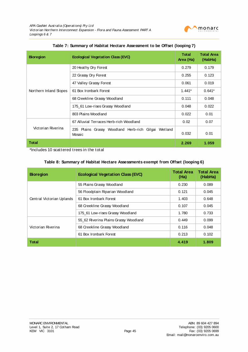
APA GasNet Australia (Operations) Pty Ltd Victorian Northern Interconnect Expansion - Flora and Fauna Assessment PART A Loopings 6 & 7
Table 7: Summary of Habitat Hectare Assessment to be Offset (looping 7)
Bioregion Ecological Vegetation Class (EVC) Total
Area (Ha) Total Area (HabHa)
Northern Inland Slopes
20 Heathy Dry Forest 0.279 0.179
22 Grassy Dry Forest 0.255 0.123
47 Valley Grassy Forest 0.061 0.019
61 Box Ironbark Forest 1.441* 0.641*
68 Creekline Grassy Woodland 0.111 0.048
175_61 Low-rises Grassy Woodland 0.048 0.022
803 Plains Woodland 0.022 0.01
Victorian Riverina
67 Alluvial Terraces Herb-rich Woodland 0.02 0.07
235 Plains Grassy Woodland Herb-rich Gilgai Wetland Mosaic 0.032 0.01
Total 2.269 1.059
*Includes 10 scattered trees in the total
Table 8: Summary of Habitat Hectare Assessments exempt from Offset (looping 6)
Bioregion Ecological Vegetation Class (EVC) Total Area (Ha)
Total Area (HabHa)
Central Victorian Uplands
55 Plains Grassy Woodland 0.230 0.089
56 Floodplain Riparian Woodland 0.121 0.045
61 Box Ironbark Forest 1.403 0.648
68 Creekline Grassy Woodland 0.107 0.045
175_61 Low-rises Grassy Woodland 1.780 0.733
Victorian Riverina
55_62 Riverina Plains Grassy Woodland 0.449 0.099
68 Creekline Grassy Woodland 0.116 0.048
61 Box Ironbark Forest 0.213 0.102
Total 4.419 1.809
MONARC ENVIRONMENTAL ABN: 89 604 427 894 Level 1, Suite 2, 17 Cotham Road Telephone: (03) 9205 0600 KEW VIC 3101 Page 45 Fax: (03) 9205 0699
Email: [email protected]
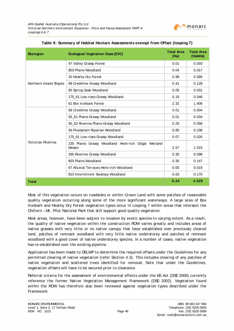
APA GasNet Australia (Operations) Pty Ltd Victorian Northern Interconnect Expansion - Flora and Fauna Assessment PART A Loopings 6 & 7
Table 9: Summary of Habitat Hectare Assessments exempt from Offset (looping 7)
Bioregion Ecological Vegetation Class (EVC) Total Area (Ha)
Total Area (HabHa)
Northern Inland Slopes
47 Valley Grassy Forest 0.01 0.003
803 Plains Woodland 0.04 0.017
20 Heathy Dry Forest 0.98 0.589
68 Creekline Grassy Woodland 0.41 0.128
80 Spring Soak Woodland 0.05 0.031
175_61 Low-rises Grassy Woodland 0.19 0.046
61 Box Ironbark Forest 2.32 1.406
Victorian Riverina
68 Creekline Grassy Woodland 0.01 0.004
55_61 Plains Grassy Woodland 0.01 0.034
55_62 Riverina Plains Grassy Woodland 0.29 0.058
56 Floodplain Riparian Woodland 0.85 0.238
175_61 Low-rises Grassy Woodland 0.07 0.026
235 Plains Grassy Woodland Herb-rich Gilgai Wetland Mosaic 2.57 1.015
295 Riverine Grassy Woodland 0.35 0.098
803 Plains Woodland 0.35 0.147
67 Alluvial Terraces Herb-rich Woodland 0.05 0.019
813 Intermittent Swampy Woodland 0.63 0.170
Total
9.24 4.029
Most of this vegetation occurs on roadsides or within Crown Land with some patches of reasonable quality vegetation occurring along some of the more significant waterways. A large area of Box Ironbark and Heathy Dry Forest vegetation types occur in Looping 7 within areas that intersect the Chiltern – Mt. Pilot National Park that still support good quality vegetation.
Most areas, however, have been subject to invasion by exotic species to varying extent. As a result, the quality of native vegetation within the construction ROW varies greatly and includes areas of native grasses with very little or no native canopy that have established over previously cleared land, patches of remnant woodland with very little native understorey and patches of remnant woodland with a good cover of native understorey species. In a number of cases, native vegetation has re-established over the existing pipeline.
Application has been made to DELWP to determine the required offsets under the Guidelines for any permitted clearing of native vegetation (refer Section 4.3). This includes clearing of any patches of native vegetation and scattered trees identified for removal. Note that under the Guidelines, vegetation offsets will have to be secured prior to clearance.
Referral criteria for the assessment of environmental effects under the EE Act (DSE 2006) currently reference the former Native Vegetation Management Framework (DSE 2002). Vegetation found within the ROW has therefore also been reviewed against vegetation types described under the Framework.
MONARC ENVIRONMENTAL ABN: 89 604 427 894 Level 1, Suite 2, 17 Cotham Road Telephone: (03) 9205 0600 KEW VIC 3101 Page 46 Fax: (03) 9205 0699
Email: [email protected]
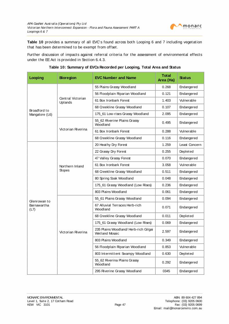
APA GasNet Australia (Operations) Pty Ltd Victorian Northern Interconnect Expansion - Flora and Fauna Assessment PART A Loopings 6 & 7
Table 10 provides a summary of all EVC’s found across both Looping 6 and 7 including vegetation that has been determined to be exempt from offset.
Further discussion of impacts against referral criteria for the assessment of environmental effects under the EE Act is provided in Section 6.4.3.
Table 10: Summary of EVCs Recorded per Looping, Total Area and Status
Looping Bioregion EVC Number and Name Total Area (Ha) Status
Broadford to Mangalore (L6)
Central Victorian Uplands
55 Plains Grassy Woodland 0.268 Endangered
56 Floodplain Riparian Woodland 0.121 Endangered
61 Box Ironbark Forest 1.403 Vulnerable
68 Creekline Grassy Woodland 0.107 Endangered
175_61 Low-rises Grassy Woodland 2.095 Endangered
Victorian Riverina
55_62 Riverine Plains Grassy Woodland 0.495 Endangered
61 Box Ironbark Forest 0.288 Vulnerable
68 Creekline Grassy Woodland 0.116 Endangered
Glenrowan to Barnawartha (L7)
Northern Inland Slopes
20 Heathy Dry Forest 1.259 Least Concern
22 Grassy Dry Forest 0.255 Depleted
47 Valley Grassy Forest 0.070 Endangered
61 Box Ironbark Forest 3.058 Vulnerable
68 Creekline Grassy Woodland 0.511 Endangered
80 Spring Soak Woodland 0.048 Endangered
175_61 Grassy Woodland (Low Rises) 0.236 Endangered
803 Plains Woodland 0.061 Endangered
Victorian Riverina
55_61 Plains Grassy Woodland 0.094 Endangered
67 Alluvial Terraces Herb-rich Woodland 0.071 Endangered
68 Creekline Grassy Woodland 0.011 Depleted
175_61 Grassy Woodland (Low Rises) 0.069 Endangered
235 Plains Woodland/Herb-rich Gilgai Wetland Mosaic 2.597 Endangered
803 Plains Woodland 0.349 Endangered
56 Floodplain Riparian Woodland 0.853 Vulnerable
803 Intermittent Swampy Woodland 0.630 Depleted
55_62 Riverina Plains Grassy Woodland 0.292 Endangered
295 Riverine Grassy Woodland 0345 Endangered
MONARC ENVIRONMENTAL ABN: 89 604 427 894 Level 1, Suite 2, 17 Cotham Road Telephone: (03) 9205 0600 KEW VIC 3101 Page 47 Fax: (03) 9205 0699
Email: [email protected]
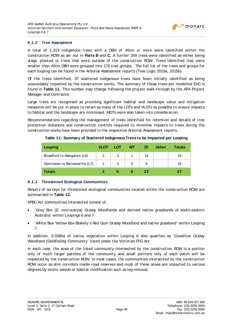
APA GasNet Australia (Operations) Pty Ltd Victorian Northern Interconnect Expansion - Flora and Fauna Assessment PART A Loopings 6 & 7
6.1.2 Tree Assessment
A total of 1,313 indigenous trees with a DBH of 40cm or more were identified within the construction ROW as set out in Parts B and C. A further 259 trees were identified as either being stags, planted or trees that were outside of the construction ROW. Trees identified that were smaller than 40cm DBH were grouped into 176 tree groups. The full list of the trees and groups for each looping can be found in the Arborist Assessment reports (Tree Logic 2015a, 2015b).
Of the trees identified, 37 scattered indigenous trees have been initially identified as being unavoidably impacted by the construction works. The summary of these trees per modelled EVC is found in Table 11. This number may change following the project walk-through by the APA Project Manager and Contractor.
Large trees are recognised as providing significant habitat and landscape value and mitigation measures will be put in place to retain as many of the LOTs and VLOTs as possible to ensure impacts to habitat and the landscape are minimised. MOTs were also taken into consideration.
Recommendations regarding the management of trees identified for retention and details of tree protection distances and construction controls required to minimise impacts to trees during the construction works have been provided in the respective Arborist Assessment reports.
Table 11: Summary of Scattered Indigenous Trees to be Impacted per Looping
Looping VLOT LOT MT ST Other Totals
Broadford to Mangalore (L6) 1 3 1 14 19
Glenrowan to Barnawartha (L7) 1 3 5 9 18
Totals 2 6 6 23 37
6.1.3 Threatened Ecological Communities
Results of surveys for threatened ecological communities located within the construction ROW are summarised in Table 12.
EPBC Act communities intersected consist of:
• ‘Grey Box (E. microcarpa) Grassy Woodlands and derived native grasslands of south-eastern Australia’ within Loopings 6 and 7.
• ‘White Box-Yellow Box-Blakely’s Red Gum Grassy Woodland and native grassland’ within Looping 7.
In addition, 0.038ha of native vegetation within Looping 6 also qualifies as ‘Creekline Grassy Woodland (Goldfields) Community’ listed under the Victorian FFG Act.
In each case, the area of the listed community intersected by the construction ROW is a portion only of much larger patches of the community and small portions only of each patch will be impacted by the construction ROW. In most cases, the communities intersected by the construction ROW occur as slim corridors inside road reserves and most of these areas are impacted to various degrees by exotic weeds or habitat modification such as log removal.
MONARC ENVIRONMENTAL ABN: 89 604 427 894 Level 1, Suite 2, 17 Cotham Road Telephone: (03) 9205 0600 KEW VIC 3101 Page 48 Fax: (03) 9205 0699
Email: [email protected]
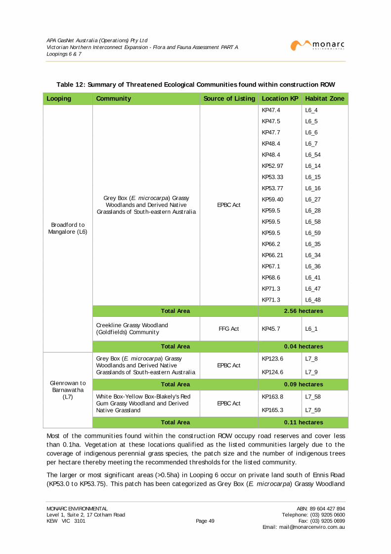
APA GasNet Australia (Operations) Pty Ltd Victorian Northern Interconnect Expansion - Flora and Fauna Assessment PART A Loopings 6 & 7
Table 12: Summary of Threatened Ecological Communities found within construction ROW
Looping Community Source of Listing Location KP Habitat Zone
Broadford to Mangalore (L6)
Grey Box (E. microcarpa) Grassy Woodlands and Derived Native
Grasslands of South-eastern Australia EPBC Act
KP47.4 L6_4
KP47.5 L6_5
KP47.7 L6_6
KP48.4 L6_7
KP48.4 L6_54
KP52.97 L6_14
KP53.33 L6_15
KP53.77 L6_16
KP59.40 L6_27
KP59.5 L6_28
KP59.5 L6_58
KP59.5 L6_59
KP66.2 L6_35
KP66.21 L6_34
KP67.1 L6_36
KP68.6 L6_41
KP71.3 L6_47
KP71.3 L6_48
Total Area 2.56 hectares
Creekline Grassy Woodland (Goldfields) Community FFG Act KP45.7 L6_1
Total Area 0.04 hectares
Glenrowan to Barnawatha
(L7)
Grey Box (E. microcarpa) Grassy Woodlands and Derived Native Grasslands of South-eastern Australia
EPBC Act KP123.6 L7_8
KP124.6 L7_9
Total Area 0.09 hectares
White Box-Yellow Box-Blakely's Red Gum Grassy Woodland and Derived Native Grassland
EPBC Act KP163.8 L7_58
KP165.3 L7_59
Total Area 0.11 hectares
Most of the communities found within the construction ROW occupy road reserves and cover less than 0.1ha. Vegetation at these locations qualified as the listed communities largely due to the coverage of indigenous perennial grass species, the patch size and the number of indigenous trees per hectare thereby meeting the recommended thresholds for the listed community.
The larger or most significant areas (>0.5ha) in Looping 6 occur on private land south of Ennis Road (KP53.0 to KP53.75). This patch has been categorized as Grey Box (E. microcarpa) Grassy Woodland
MONARC ENVIRONMENTAL ABN: 89 604 427 894 Level 1, Suite 2, 17 Cotham Road Telephone: (03) 9205 0600 KEW VIC 3101 Page 49 Fax: (03) 9205 0699
Email: [email protected]
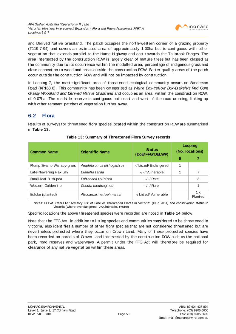
APA GasNet Australia (Operations) Pty Ltd Victorian Northern Interconnect Expansion - Flora and Fauna Assessment PART A Loopings 6 & 7
and Derived Native Grassland. The patch occupies the north-western corner of a grazing property (T119-7-94) and covers an estimated area of approximately 1.00ha but is contiguous with other vegetation that extends parallel to the Hume Highway and east towards the Tallarook Ranges. The area intersected by the construction ROW is largely clear of mature trees but has been classed as the community due to its occurrence within the modelled area, percentage of indigenous grass and close connection to woodland areas outside the construction ROW. Better quality areas of the patch occur outside the construction ROW and will not be impacted by construction.
In Looping 7, the most significant area of threatened ecological community occurs on Sanderson Road (KP163.8). This community has been categorised as White Box-Yellow Box-Blakely's Red Gum Grassy Woodland and Derived Native Grassland and occupies an area, within the construction ROW, of 0.07ha. The roadside reserve is contiguous both east and west of the road crossing, linking up with other remnant patches of vegetation further away.
6.2 Flora
Results of surveys for threatened flora species located within the construction ROW are summarised in Table 13.
Table 13: Summary of Threatened Flora Survey records
Common Name Scientific Name Status (DoE/FFG/DELWP)
Looping (No. locations)
6 7
Plump Swamp Wallaby-grass Amphibromus pithogastrus -/Listed/Endangered 1
Late-flowering Flax Lily Dianella tarda -/-/Vulnerable 1 7
Small-leaf Bush-pea Pultenaea foliolosa -/-/Rare 3
Western Golden-tip Goodia medicaginea -/-/Rare 1
Buloke (planted) Allocasuarina luehmannii -/Listed/Vulnerable 1 x Planted
Notes: DELWP refers to ‘Advisory List of Rare or Threatened Plants in Victoria’ (DEPI 2014) and conservation status in Victoria (where e=endangered, v=vulnerable, r=rare)
Specific locations the above threatened species were recorded are noted in Table 14 below.
Note that the FFG Act, in addition to listing species and communities considered to be threatened in Victoria, also identifies a number of other flora species that are not considered threatened but are nevertheless protected where they occur on Crown Land. Many of these protected species have been recorded on parcels of Crown Land intersected by the construction ROW such as the national park, road reserves and waterways. A permit under the FFG Act will therefore be required for clearance of any native vegetation within these areas.
MONARC ENVIRONMENTAL ABN: 89 604 427 894 Level 1, Suite 2, 17 Cotham Road Telephone: (03) 9205 0600 KEW VIC 3101 Page 50 Fax: (03) 9205 0699
Email: [email protected]
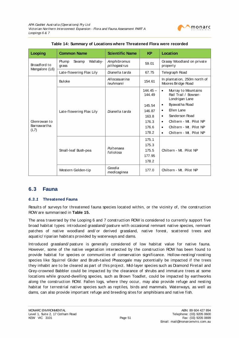
APA GasNet Australia (Operations) Pty Ltd Victorian Northern Interconnect Expansion - Flora and Fauna Assessment PART A Loopings 6 & 7
Table 14: Summary of Locations where Threatened Flora were recorded
Looping Common Name Scientific Name KP Location
Broadford to Mangalore (L6)
Plump Swamp Wallaby-grass
Amphibromus pithogastrus 59.01 Grassy Woodland on private
property
Late-flowering Flax Lily Dianella tarda 67.75 Telegraph Road
Glenrowan to Barnawartha (L7)
Buloke Allocasuarina leuhmanii 154.61 In plantation, 250m north of
Moores Bridge Road
Late-flowering Flax Lily Dianella tarda
144.45 – 144.49
145.54 146.87 163.8 176.3 176.6 178.2
• Murray to Mountains Rail Trail / Bowser-Londrigan Lane
• Byawatha Road
• Ellen Lane
• Sanderson Road
• Chiltern - Mt. Pilot NP
• Chiltern - Mt. Pilot NP
• Chiltern - Mt. Pilot NP
Small-leaf Bush-pea Pultenaea foliolosa
175.1 175.3 175.5 177.95 178.2
Chiltern - Mt. Pilot NP
Western Golden-tip Goodia medicaginea 177.0 Chiltern - Mt. Pilot NP
6.3 Fauna
6.3.1 Threatened Fauna
Results of surveys for threatened fauna species located within, or the vicinity of, the construction ROW are summarised in Table 15.
The area traversed by the Looping 6 and 7 construction ROW is considered to currently support five broad habitat types: introduced grassland/pasture with occasional remnant native species, remnant patches of native woodland and/or derived grassland, native forest, scattered trees and aquatic/riparian habitats provided by waterways and dams.
Introduced grassland/pasture is generally considered of low habitat value for native fauna. However, some of the native vegetation intersected by the construction ROW has been found to provide habitat for species or communities of conservation significance. Hollow-nesting/roosting species like Squirrel Glider and Brush-tailed Phascogale may potentially be impacted if the trees they inhabit are to be cleared as part of this project. Mid-layer species such as Diamond Firetail and Grey-crowned Babbler could be impacted by the clearance of shrubs and immature trees at some locations while ground-dwelling species, such as Brown Toadlet, could be impacted by earthworks along the construction ROW. Fallen logs, where they occur, may also provide refuge and nesting habitat for terrestrial native species such as reptiles, birds and mammals. Waterways, as well as dams, can also provide important refuge and breeding sites for amphibians and native fish.
MONARC ENVIRONMENTAL ABN: 89 604 427 894 Level 1, Suite 2, 17 Cotham Road Telephone: (03) 9205 0600 KEW VIC 3101 Page 51 Fax: (03) 9205 0699
Email: [email protected]
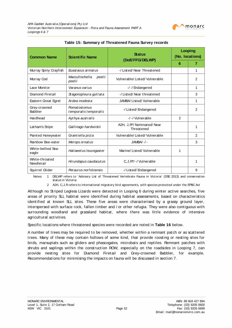
APA GasNet Australia (Operations) Pty Ltd Victorian Northern Interconnect Expansion - Flora and Fauna Assessment PART A Loopings 6 & 7
Table 15: Summary of Threatened Fauna Survey records
Common Name Scientific Name Status
(DoE/FFG/DELWP)
Looping (No. locations)
6 7
Murray Spiny Crayfish Euastacus armatus -/Listed/Near Threatened 1
Murray Cod Maccullochella peelii peelii Vulnerable/Listed/Vulnerable 2
Lace Monitor Varanus varius -/-/Endangered 1
Diamond Firetail Stagonopleura guttata -/Listed/Near threatened 3
Eastern Great Egret Ardea modesta JAMBA/Listed/Vulnerable 1
Grey-crowned Babbler
Pomatostomus temporalis temporalis -/Listed/Endangered 2
Hardhead Aythya australis -/-/Vulnerable 2
Latham's Snipe Gallinago hardwickii A2H, J,R*/Nominated/Near Threatened 1
Painted Honeyeater Grantiella picta Vulnerable/Listed/Vulnerable 2
Rainbow Bee-eater Merops ornatus JAMBA/-/- 3
White-bellied Sea-eagle Haliaeetus leucogaster Marine/Listed/Vulnerable 1
White-throated Needletail Hirundapus caudacutus C,J,R*/-/Vulnerable 1
Squirrel Glider Petaurus norfolcensis -/Listed/Endangered 9
Notes: 1 DELWP refers to ‘Advisory List of Threatened Vertebrate Fauna in Victoria’ (DSE 2013) and conservation status in Victoria
2 A2H, C,J,R refers to international migratory bird agreements, with species protected under the EPBC Act
Although no Striped Legless Lizards were detected in Looping 6 during winter active searches, five areas of priority SLL habitat were identified during habitat assessments, based on characteristics identified at known SLL sites. These five areas were characterised by a grassy ground layer, interspersed with surface rock, fallen timber and /or other refugia. They were also contiguous with surrounding woodland and grassland habitat, where there was little evidence of intensive agricultural activities.
Specific locations where threatened species were recorded are noted in Table 16 below.
A number of trees may be required to be removed, whether within a remnant patch or as scattered trees. Many of these may contain hollows of some kind, that provide roosting or nesting sites for birds, marsupials such as gliders and phascogales, microbats and reptiles. Remnant patches with shrubs and saplings within the construction ROW, especially on the roadsides in Looping 7, can provide nesting sites for Diamond Firetail and Grey-crowned Babbler, for example. Recommendations for minimising the impacts on fauna will be discussed in section 7.
MONARC ENVIRONMENTAL ABN: 89 604 427 894 Level 1, Suite 2, 17 Cotham Road Telephone: (03) 9205 0600 KEW VIC 3101 Page 52 Fax: (03) 9205 0699
Email: [email protected]
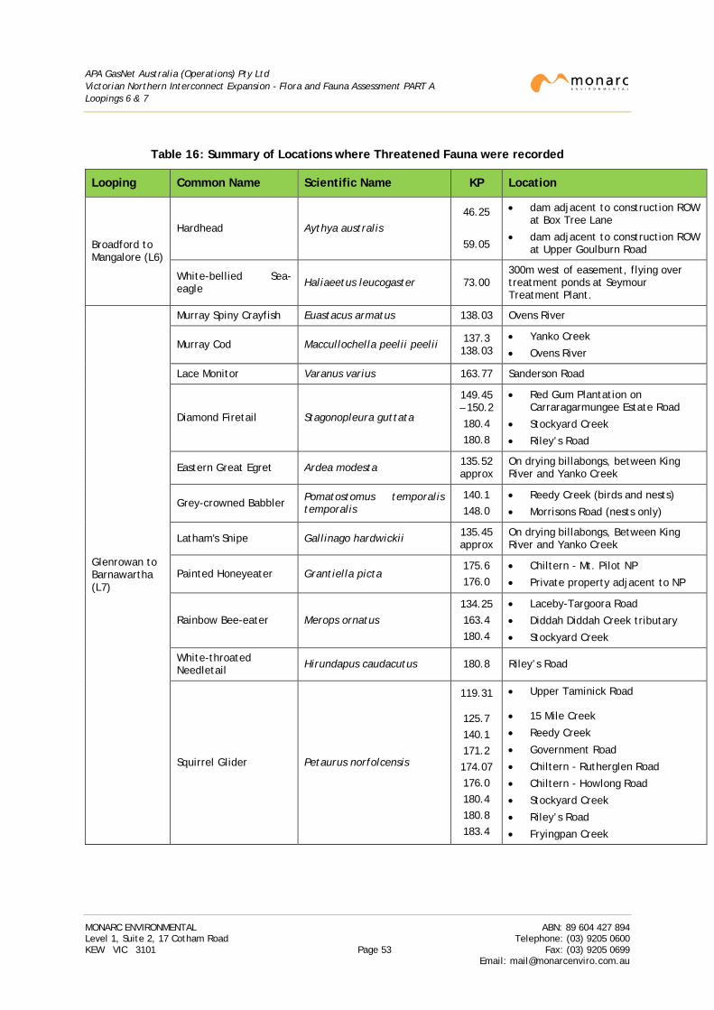
APA GasNet Australia (Operations) Pty Ltd Victorian Northern Interconnect Expansion - Flora and Fauna Assessment PART A Loopings 6 & 7
Table 16: Summary of Locations where Threatened Fauna were recorded
Looping Common Name Scientific Name KP Location
Broadford to Mangalore (L6)
Hardhead Aythya australis 46.25
59.05
• dam adjacent to construction ROW at Box Tree Lane
• dam adjacent to construction ROW at Upper Goulburn Road
White-bellied Sea-eagle Haliaeetus leucogaster 73.00
300m west of easement, flying over treatment ponds at Seymour Treatment Plant.
Glenrowan to Barnawartha (L7)
Murray Spiny Crayfish Euastacus armatus 138.03 Ovens River
Murray Cod Maccullochella peelii peelii 137.3 138.03
• Yanko Creek
• Ovens River
Lace Monitor Varanus varius 163.77 Sanderson Road
Diamond Firetail Stagonopleura guttata
149.45 – 150.2
180.4 180.8
• Red Gum Plantation on Carraragarmungee Estate Road
• Stockyard Creek
• Riley’s Road
Eastern Great Egret Ardea modesta 135.52 approx
On drying billabongs, between King River and Yanko Creek
Grey-crowned Babbler Pomatostomus temporalis temporalis
140.1 148.0
• Reedy Creek (birds and nests)
• Morrisons Road (nests only)
Latham's Snipe Gallinago hardwickii 135.45 approx
On drying billabongs, Between King River and Yanko Creek
Painted Honeyeater Grantiella picta 175.6 176.0
• Chiltern - Mt. Pilot NP
• Private property adjacent to NP
Rainbow Bee-eater Merops ornatus 134.25 163.4 180.4
• Laceby-Targoora Road
• Diddah Diddah Creek tributary
• Stockyard Creek
White-throated Needletail Hirundapus caudacutus 180.8 Riley’s Road
Squirrel Glider Petaurus norfolcensis
119.31
125.7 140.1 171.2 174.07 176.0 180.4 180.8 183.4
• Upper Taminick Road
• 15 Mile Creek
• Reedy Creek
• Government Road
• Chiltern - Rutherglen Road
• Chiltern - Howlong Road
• Stockyard Creek
• Riley’s Road
• Fryingpan Creek
MONARC ENVIRONMENTAL ABN: 89 604 427 894 Level 1, Suite 2, 17 Cotham Road Telephone: (03) 9205 0600 KEW VIC 3101 Page 53 Fax: (03) 9205 0699
Email: [email protected]
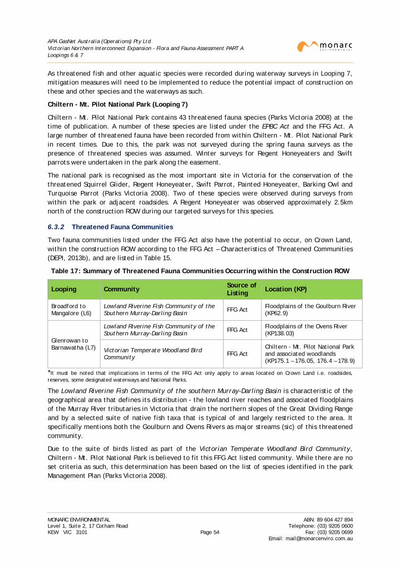
APA GasNet Australia (Operations) Pty Ltd Victorian Northern Interconnect Expansion - Flora and Fauna Assessment PART A Loopings 6 & 7
As threatened fish and other aquatic species were recorded during waterway surveys in Looping 7, mitigation measures will need to be implemented to reduce the potential impact of construction on these and other species and the waterways as such.
Chiltern - Mt. Pilot National Park (Looping 7)
Chiltern - Mt. Pilot National Park contains 43 threatened fauna species (Parks Victoria 2008) at the time of publication. A number of these species are listed under the EPBC Act and the FFG Act. A large number of threatened fauna have been recorded from within Chiltern - Mt. Pilot National Park in recent times. Due to this, the park was not surveyed during the spring fauna surveys as the presence of threatened species was assumed. Winter surveys for Regent Honeyeaters and Swift parrots were undertaken in the park along the easement.
The national park is recognised as the most important site in Victoria for the conservation of the threatened Squirrel Glider, Regent Honeyeater, Swift Parrot, Painted Honeyeater, Barking Owl and Turquoise Parrot (Parks Victoria 2008). Two of these species were observed during surveys from within the park or adjacent roadsides. A Regent Honeyeater was observed approximately 2.5km north of the construction ROW during our targeted surveys for this species.
6.3.2 Threatened Fauna Communities
Two fauna communities listed under the FFG Act also have the potential to occur, on Crown Land, within the construction ROW according to the FFG Act – Characteristics of Threatened Communities (DEPI, 2013b), and are listed in Table 15.
Table 17: Summary of Threatened Fauna Communities Occurring within the Construction ROW
Looping Community Source of Listing Location (KP)
Broadford to Mangalore (L6)
Lowland Riverine Fish Community of the Southern Murray-Darling Basin FFG Act Floodplains of the Goulburn River
(KP62.9)
Glenrowan to Barnawatha (L7)
Lowland Riverine Fish Community of the Southern Murray-Darling Basin FFG Act Floodplains of the Ovens River
(KP138.03)
Victorian Temperate Woodland Bird Community FFG Act
Chiltern - Mt. Pilot National Park and associated woodlands (KP175.1 – 176.05, 176.4 – 178.9)
*It must be noted that implications in terms of the FFG Act only apply to areas located on Crown Land i.e. roadsides, reserves, some designated waterways and National Parks.
The Lowland Riverine Fish Community of the southern Murray-Darling Basin is characteristic of the geographical area that defines its distribution - the lowland river reaches and associated floodplains of the Murray River tributaries in Victoria that drain the northern slopes of the Great Dividing Range and by a selected suite of native fish taxa that is typical of and largely restricted to the area. It specifically mentions both the Goulburn and Ovens Rivers as major streams (sic) of this threatened community.
Due to the suite of birds listed as part of the Victorian Temperate Woodland Bird Community, Chiltern - Mt. Pilot National Park is believed to fit this FFG Act listed community. While there are no set criteria as such, this determination has been based on the list of species identified in the park Management Plan (Parks Victoria 2008).
MONARC ENVIRONMENTAL ABN: 89 604 427 894 Level 1, Suite 2, 17 Cotham Road Telephone: (03) 9205 0600 KEW VIC 3101 Page 54 Fax: (03) 9205 0699
Email: [email protected]
APA GasNet Australia (Operations) Pty Ltd Victorian Northern Interconnect Expansion - Flora and Fauna Assessment PART A Loopings 6 & 7
6.4 Impact Assessment
Legislative obligations with respect to flora and fauna and the potential impacts associated with construction activities are reviewed below.
6.4.1 Environment Protection and Biodiversity Conservation Act 1999
The potential impacts of the project in relation to the listed triggers have been assessed using the EPBC Act Administrative Guidelines on Significance:
• There are no Ramsar wetlands within or in the vicinity of the construction ROW in either Looping 6 or 7.
• Parts of the Goulburn River in Looping 6 and the Ovens River in Looping 7 are listed on the Directory of Important Wetlands in Australia, approximately 40km and 14km downstream of the construction ROW respectively. As these crossings are to be drilled using HDD and the distance from the listed sections, it is predicted that there will be no impacts on these wetlands;
• The assessment of the project has identified the presence of vegetation consistent with two EPBC Act listed ecological communities within the construction ROW. These are:
o Grey Box (Eucalyptus microcarpa) Grassy Woodlands and Derived Native Grasslands of South-eastern Victoria;
o White Box-Yellow Box-Blakely’s Red Gum Grassy Woodland and Derived Native Grassland;
• Extensive surveys of the construction ROW have identified the following locations with a threatened fauna species listed under the EPBC Act:
o Murray Cod at Ovens River and Yanko Creek, near Wangaratta (Looping 7)
o Eastern Great Egret and Latham’s Snipe between King River and Yanko Creek (Looping 7)
o Painted Honeyeater in Chiltern - Mt. Pilot National Park and adjacent private property (Looping 7)
o Rainbow Bee-eater at Show Creek, west of Glenrowan, Diddah Diddah and Stockyards Creeks near Springhurst and Chiltern respectively (Looping 7)
o White-bellied Sea-eagle observed over treatment ponds at Seymour Treatment Plant (Looping 6) to the west of the construction ROW
o White-throated Needletail over Riley’s Road, north-east of Chiltern (Looping 7)
The construction ROW is not considered to intersect critical habitat of listed migratory species or provide sufficient habitat for an ecologically significant proportion of any of the listed species. However construction activities could interrupt the breeding activities of threatened fauna.
Refer to Table 16 for a summary of the locations of MNES located within, or in the vicinity of, the construction ROW.
Extensive management measures have been recommended to manage and minimise impacts to MNES (refer Section 7). The construction ROW has been reduced (generally to 20m, except in Chiltern-Mt Pilot National Park where the ROW is narrowed to 16.5m) to minimise impacts to the communities. It is therefore considered that impact to any of the EPBC Act listed communities intersected by the construction ROW is not significant. Overall impact to listed communities is also not considered significant.
MONARC ENVIRONMENTAL ABN: 89 604 427 894 Level 1, Suite 2, 17 Cotham Road Telephone: (03) 9205 0600 KEW VIC 3101 Page 55 Fax: (03) 9205 0699
Email: [email protected]
APA GasNet Australia (Operations) Pty Ltd Victorian Northern Interconnect Expansion - Flora and Fauna Assessment PART A Loopings 6 & 7
Avoidance and mitigation measures relating to fauna are also recommended section 7. These are primarily focused on Chiltern - Mt. Pilot National Park and the various waterways that EPBC Act species have been recorded.
However, it is recommended that a referral under the EPBC Act be prepared for forwarding to the Commonwealth Department of Environment to determine whether the proposed action is a controlled action under the EPBC Act.
6.4.2 Flora and Fauna Guarantee Act 1988
The assessment has noted the following:
• Presence of fauna species listed under the FFG Act at a number of locations within the construction ROW, or in the vicinity, of Looping 6 and 7. These include:
o Two records of Murray Cod.
o One record of Murray Spiny Crayfish.
o Three records of Diamond Firetail.
o One record of Eastern Great Egret.
o Two records of Grey-crowned Babbler.
o One record of Latham’s Snipe (nominated not listed).
o Two records of Painted Honeyeater.
o One record of White-bellied Sea-eagle
o Nine records of Squirrel Glider.
The FFG Act applies to all Crown Land and permits are required under the FFG Act for the taking of listed species in these areas. A permit is also required where non-threatened flora that is protected on Crown Land requires clearance. Therefore a permit will be required where clearance of native vegetation or habitat is required on areas such as roadsides and Crown Land reserves.
• Two threatened fauna communities are also believed to exist in both loopings:
o Lowland Riverine Fish Community of the southern Murray-Darling Basin.
o Victorian Temperate Woodland Bird Community.
Mitigation measures to minimise impacts on these communities are discussed further in Parts B and C and have been factored into the other areas and for species that occur within the same locations.
• Six threatening processes listed under the FFG Act could be applicable to the project if appropriate steps were not taken to manage impacts:
o Degradation of native riparian vegetation along Victorian rivers and streams.
o Habitat fragmentation as a threatening process for fauna in Victoria.
o Increase in sediment input into Victorian rivers and streams due to human activities.
o Infection of amphibians with Chytrid fungus resulting in chytridiomycosis.
o Invasion of native vegetation by ‘environmental weeds’.
o Loss of hollow-bearing trees from Victorian native forests.
MONARC ENVIRONMENTAL ABN: 89 604 427 894 Level 1, Suite 2, 17 Cotham Road Telephone: (03) 9205 0600 KEW VIC 3101 Page 56 Fax: (03) 9205 0699
Email: [email protected]

APA GasNet Australia (Operations) Pty Ltd Victorian Northern Interconnect Expansion - Flora and Fauna Assessment PART A Loopings 6 & 7
Part of the existing easement was cleared for the construction of the original pipeline in 1975. While removal of native vegetation will be required to allow the project to proceed, the placement of the new pipeline within the existing easement will minimise the potential for removal or fragmentation of existing habitat that may occur with the creation of a new alignment.
6.4.3 Environment Effects Act 1978
The Environment Effects Act requires the preparation of an Environment Effects Statement (‘EES’) where proposed works may potentially have a significant effect on the environment. A project with potential adverse environmental effects that individually or in combination could be significant in a regional or State context should generally be referred to the Minister administering the Environment Effects Act to determine whether an EES is required.
A summary of those criteria relevant to biodiversity issues, and an assessment of their application to the project, is provided in Table 18.
A total of 3.23 ha of native vegetation subject to offset occurs across both Looping 6 and 7. Of this, 0.69ha is considered to be an EVC identified as endangered by DELWP.
Subject to any further measures taken to reduce or manage impacts, it is therefore likely that a referral will be required for forwarding to the Minister of Environment to determine whether the proposed action will require the preparation of an Environment Effects Statement.
MONARC ENVIRONMENTAL ABN: 89 604 427 894 Level 1, Suite 2, 17 Cotham Road Telephone: (03) 9205 0600 KEW VIC 3101 Page 57 Fax: (03) 9205 0699
Email: [email protected]
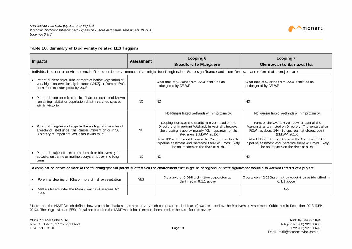
APA GasNet Australia (Operations) Pty Ltd Victorian Northern Interconnect Expansion - Flora and Fauna Assessment PART A Loopings 6 & 7
Table 18: Summary of Biodiversity related EES Triggers
Impacts Assessment Looping 6
Broadford to Mangalore Looping 7
Glenrowan to Barnawartha
Individual potential environmental effects on the environment that might be of regional or State significance and therefore warrant referral of a project are
• Potential clearing of 10ha or more of native vegetation of very high conservation significance (VHCS) or from an EVC identified as endangered by DSE2
Clearance of 0.399ha from EVCs identified as endangered by DELWP
Clearance of 0.294ha from EVCs identified as endangered by DELWP
• Potential long-term loss of significant proportion of known remaining habitat or population of a threatened species within Victoria
NO NO NO
• Potential long-term change to the ecological character of a wetland listed under the Ramsar Convention or in ‘A Directory of Important Wetlands in Australia’
NO
No Ramsar listed wetlands within proximity.
Looping 6 crosses the Goulburn River listed on the Directory of Important Wetlands in Australia however the crossing is approximately 40km upstream of the
listed area. (DELWP, 2015c) Also HDD will be used to cross the Goulburn within the pipeline easement and therefore there will most likely
be no impacts on the river as such.
No Ramsar listed wetlands within proximity.
Parts of the Ovens River, downstream of the Wangaratta, are listed on Directory. The construction
ROW lies about 14km to upstream at closest point. (DELWP, 2015c)
Also HDD will be used to cross the Ovens within the pipeline easement and therefore there will most likely
be no impacts on the river as such.
• Potential major effects on the health or biodiversity of aquatic, estuarine or marine ecosystems over the long term
NO NO NO
A combination of two or more of the following types of potential effects on the environment that might be of regional or State significance would also warrant referral of a project
• Potential clearing of 10ha or more of native vegetation YES Clearance of 0.964ha of native vegetation as identified in 6.1.1 above
Clearance of 2.269ha of native vegetation as identified in 6.1.1 above
• Matters listed under the Flora & Fauna Guarantee Act 1988
NO
2 Note that the NVMF (which defines how vegetation is classed as high or very high conservation significance) was replaced by the Biodiversity Assessment Guidelines in December 2013 (DEPI 2013). The triggers for an EES referral are based on the NVMF which has therefore been used as the basis for this review
MONARC ENVIRONMENTAL ABN: 89 604 427 894 Level 1, Suite 2, 17 Cotham Road Telephone: (03) 9205 0600 KEW VIC 3101 Page 58 Fax: (03) 9205 0699
Email: [email protected]
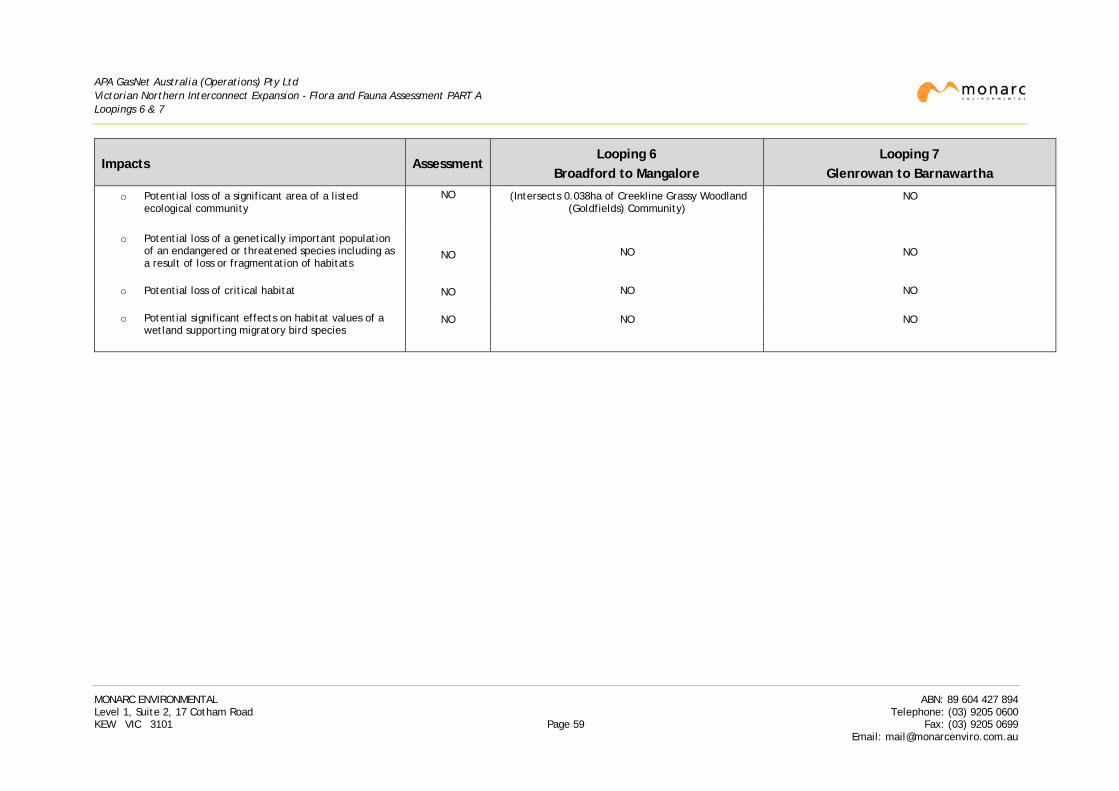
APA GasNet Australia (Operations) Pty Ltd Victorian Northern Interconnect Expansion - Flora and Fauna Assessment PART A Loopings 6 & 7
Impacts Assessment Looping 6
Broadford to Mangalore Looping 7
Glenrowan to Barnawartha
o Potential loss of a significant area of a listed ecological community
NO (Intersects 0.038ha of Creekline Grassy Woodland (Goldfields) Community)
NO
o Potential loss of a genetically important population of an endangered or threatened species including as a result of loss or fragmentation of habitats
NO
NO
NO
o Potential loss of critical habitat
NO NO NO
o Potential significant effects on habitat values of a wetland supporting migratory bird species
NO NO NO
MONARC ENVIRONMENTAL ABN: 89 604 427 894 Level 1, Suite 2, 17 Cotham Road Telephone: (03) 9205 0600 KEW VIC 3101 Page 59 Fax: (03) 9205 0699
Email: [email protected]
APA GasNet Australia (Operations) Pty Ltd Victorian Northern Interconnect Expansion - Flora and Fauna Assessment PART A Loopings 6 & 7
7. RECOMMENDATIONS
7.1 Vegetation Management
The construction of Loopings 6 or 7 will require the removal of remnant native vegetation. A summary of the overall area of native vegetation within the construction ROW can be found in section 6.1.1.
DELWP recommends the application of a three step hierarchy to minimise impacts to biodiversity issues of significance:
• Avoidance of impacts.
• Minimisation of impacts where they cannot be avoided.
• Identification of appropriate offset options where impacts are unavoidable.
The following measures have been undertaken to minimise impacts to vegetation:
o Reduction of the construction ROW (generally to 20m, except in Chiltern-Mt Pilot National Park where the ROW is narrowed to 16.5m) width where it intersects a remnant patch in order to minimise impacts to native vegetation.
o Reduction of the construction ROW to the minimum width necessary in order to avoid impacts to scattered trees that do not grow over, or near, the alignment of the proposed pipeline. This is generally possible in most areas of the construction ROW due to the open nature of the country through which the construction ROW passes.
o Shifting of the narrowed construction ROW, in some cases, ‘westwards’ over the existing pipeline (reverse ROW) to avoid impacts on remnant vegetation in the ‘eastern’ area of the construction ROW. In general, the construction process should avoid work or movement of heavy construction traffic over the existing pipeline. In some cases, however, in areas where a specialist crew is proposed, such as at waterway crossings, impacts can be reduced by shifting the narrowed construction ROW westwards over the existing pipeline. Note that this is only proposed in areas where a reduction in impacts can be demonstrated (in some properties, vegetation that has regrown ‘west’ of the existing pipeline is of similar quality to vegetation located east of the proposed pipeline);
o HDD of selected locations, generally waterways, to pass under significant vegetation as well as the waterway where possible. However, some VLOTS that lie over or near the proposed pipeline may also be identified for HDD in recognition of their habitat and landscape value.
In all attempts to minimise impacts on native vegetation, particular effort should be made to minimise impacts on Large and Very Large Old Trees whether within remnant patches or as trees scattered through the project area.
• In regards to the scattered trees, and those in patches, that occur on the construction ROW, of both loopings, an Arborist assessment has been undertaken. The report of this assessment must be used to help guide construction works around these trees where their removal can be avoided. These measures will include:
o Treatments that reduce the level of impact within the TPZ (which could damage surface oriented roots) in order to retain trees subject to potential impact associated with clear and grade activities.
MONARC ENVIRONMENTAL ABN: 89 604 427 894 Level 1, Suite 2, 17 Cotham Road Telephone: (03) 9205 0600 KEW VIC 3101 Page 60 Fax: (03) 9205 0699
Email: [email protected]
APA GasNet Australia (Operations) Pty Ltd Victorian Northern Interconnect Expansion - Flora and Fauna Assessment PART A Loopings 6 & 7
o Treatments that reduce the level of impact associated with trenching activities.
• A number of areas intersected by the construction ROW have resulted from publicly funded revegetation projects. These areas have been included in the calculations for vegetation offset requirements contained in this report, as APA have confirmed with the landowner or manager that these areas have been planted as a result of a publicly funded project.
7.2 Flora and Fauna Management
Over 450 individual flora and fauna surveys have been undertaken at sites across the project area for both Loopings 6 and 7. These surveys have been undertaken in seasons and under conditions recommended in both Commonwealth and State guidelines.
Subject to results of the final avoidance and minimisation measures, it is therefore considered that impact to any of the FFG Act listed species and communities intersected by the construction ROW is not significant.. However, a number of mitigation measures are recommended for inclusion in the CEMP and SEMP to ensure impact to these species and communities is minimised. These are discussed below.
7.3 Mitigation Measures
A Construction Environment Management Plan (CEMP) is required to be prepared for pipeline projects that fall under the Pipelines Act to ensure regulatory obligations are met and that environmental issues are appropriately managed during construction.
It is recommended that the CEMP include the practices discussed below.
7.3.1 Flora and Fauna impacts
The construction ROW contains habitat for a number of significant flora and/or fauna species based on survey findings. For example, a number of indigenous trees have been identified as solitary trees scattered across properties or within patches of remnant vegetation. As many of these contain hollows of some kind, they may provide roosting or nesting sites for birds, marsupials such as gliders and phascogales, microbats and reptiles. In some locations, salvage and/or relocation of native flora and fauna may be appropriate before native vegetation or habitat is removed.
It is recommended that a Flora and Fauna Management Plan be prepared in accordance with guidelines and protocols for approval by DELWP. Due to the sensitivities of Chiltern – Mt. Pilot National Park, a separate management plan is recommended to but prepared for works within the park. This will be done so following discussions with DELWP and Parks Victoria.
The following recommendations are for the avoidance and/or mitigation of the impacts due to construction on native species:
• Any threatened flora species that are to be impacted. This should include the following:
o If threatened flora is to be impacted then salvage must be considered prior to construction. This may take the form of plant removal, seed collection or other recommended methods.
o All individual threatened flora adjacent to/outside the construction ROW but within the easement will be flagged prior to construction.
MONARC ENVIRONMENTAL ABN: 89 604 427 894 Level 1, Suite 2, 17 Cotham Road Telephone: (03) 9205 0600 KEW VIC 3101 Page 61 Fax: (03) 9205 0699
Email: [email protected]
APA GasNet Australia (Operations) Pty Ltd Victorian Northern Interconnect Expansion - Flora and Fauna Assessment PART A Loopings 6 & 7
• A salvage plan for Striped Legless Lizard (SLL) to describe measures to be employed in the areas
of suitable habitat within Looping 6, as identified during the winter survey.
• A Fauna Management Plan to manage the impact on:
o Local hollow-dependant fauna.
o Native ground-dwelling species.
o Native species that may be breeding at the time of construction.
o Fish salvaging prior to the open-cut crossing of waterways that have the potential to contain native fish, only if the waterways are flowing at the time of construction.
Consideration should be given to the following measures to reduce the impact on local hollow-dependant fauna and other species:
• Where hollow bearing trees are to be removed, nest boxes should be installed in adjacent non-impacted vegetation at least several days prior to tree removal.
• An appropriately licenced and experienced zoologist/wildlife handler to carefully inspect all hollows for fauna using an elevated work platform (mobile tower) to inspect hollows that are not reachable by ladder, this may also include the use of an endoscope, prior to felling of hollow-bearing trees.
• Hollows to be removed wherever possible at time of inspection to avoid any further use prior to felling of the tree.
• Removed hollows to be salvaged and given to local landcare or environment groups for redistribution.
• Hollow-bearing trees to be removed carefully by qualified arborists under the direction of an appropriately licensed and experienced zoologist/wildlife handler.
• An appropriately licenced and experienced zoologist/wildlife handler to carefully inspect all hollows for fauna using an endoscope after felling of hollow-bearing trees.
As threatened aquatic species were recorded from a number of waterways, the following measures must be implemented where the construction will impact on waterways or dams:
• Boring under significant waterways, however this is dependent on the surrounding geology.
• Undertake works on waterways during periods of low or no flow wherever possible.
• Undertake fish and aquatic invertebrate salvaging or other techniques to avoid impact all together, prior to crossing of waterways.
• NECMA to be contacted where large trees are to be felled, for possible use in re-snagging projects.
• Salvaging of dams that are on floodways, close to the construction ROW, if they are to be impacted.
In addition, to minimise impacts to the ecological values within the construction ROW the following measures should be included within the CEMP to be prepared for the loopings:
• Any native vegetation that is to be removed as a result of construction works must be offset in accordance with legislative requirements.
MONARC ENVIRONMENTAL ABN: 89 604 427 894 Level 1, Suite 2, 17 Cotham Road Telephone: (03) 9205 0600 KEW VIC 3101 Page 62 Fax: (03) 9205 0699
Email: [email protected]
APA GasNet Australia (Operations) Pty Ltd Victorian Northern Interconnect Expansion - Flora and Fauna Assessment PART A Loopings 6 & 7
• Induction of employees and contractors prior to commencement of works to highlight
environmental, cultural and other construction issues (such as threatened flora and fauna, vegetation communities etc.).
• Photo monitoring points should be established prior to construction to monitor ecologically sensitive areas throughout the project including prior to construction, during construction and post-reinstatement.
• Vegetation to be retained shall be identified and located on the construction alignment sheets and clearly flagged in the field as not to be disturbed.
• Flagging of remnant vegetation prior to and during construction activities to prevent damage to the vegetation and to prevent any construction access to retained vegetation. Tree protection, if required, will be in accordance with the Australian Standard - AS 4970-2009 Protection of trees on development sites.
• An arborist be present during any vegetation clearance and trenching works within the vicinity of treed vegetation identified in the Arborist report.
• No works, including loading and unloading, storage of materials, dumping of waste, vehicle access and parking or other construction activity, will occur within areas of retained native vegetation identified in the route maps (Appendix A in each of Parts B and C of this report).
• All excavated soil should be stockpiled in areas free of remnant native vegetation.
• Stockpiles should be stored away from areas of surface water flow and not impede surface drainage or water flow.
• All waterways, drainage systems and waterbodies should be protected from the impact of sediment with appropriately installed sediment fences to prevent turbid water entering the waterway.
The following mitigation measures should be employed to reduce impacts to fauna habitat and to minimise injury or mortality of fauna:
• Adopting a safe speed limit along the construction ROW through sensitive areas (identified on the route maps) of no greater than 40kph to minimise the potential for collision with fauna moving through roadside or other remnant vegetation.
• Minimising the period and length of time that the trench remains open, particularly in areas where sensitive habitat has been identified nearby.
• Horizontal Directional Drilling of some watercourses (Goulburn, King and Ovens Rivers) and other sensitive areas to avoid impact to vegetation, flora or fauna.
• Use of end caps on pipe strings to prevent entry of fauna prior to laying.
• Daily monitoring of open sections of trench at regular intervals for trapped animals such as reptiles and small ground-dwelling mammals, particularly in areas where sensitive habitat has been identified.
• Constructing trench plugs and ramps with slopes no greater than 45% at regular intervals along the pipeline trench to provide exits for fauna.
• Checking of the open trench for fauna prior to backfill and removal of any trapped animals.
• Removal of shelter (timber, rocks, etc.) from construction ROW before clear and grade.
MONARC ENVIRONMENTAL ABN: 89 604 427 894 Level 1, Suite 2, 17 Cotham Road Telephone: (03) 9205 0600 KEW VIC 3101 Page 63 Fax: (03) 9205 0699
Email: [email protected]
APA GasNet Australia (Operations) Pty Ltd Victorian Northern Interconnect Expansion - Flora and Fauna Assessment PART A Loopings 6 & 7
• If fauna is located during the inspection, they will be relocated by a suitably qualified and
experienced animal handler that holds a current wildlife permit issued by DELWP.
• Any water accumulated within excavations will be disposed in a manner that will ensure no adverse impacts from sediment load or low dissolved oxygen levels to waterways. Water from de-watering should therefore be disposed to land via an energy-dissipating and sediment-trapping system (e.g. via grassed areas, straw bales or geotextile filter/fabrics) and should not be disposed directly into a waterbody or result in flooding of the area.
• Measures to ensure the potential for spread of chytrid fungus between waterways is minimised.
7.3.2 Chiltern - Mt. Pilot National Park
Given the sensitivities of Chiltern - Mt. Pilot National Park and the construction methods required due to the geology of the construction ROW, it is recommended that any construction within the park (KP172.7 to KP181.2) be undertaken in late summer to early autumn (February to March) to avoid the breeding seasons of most of the threatened species, especially Regent Honeyeater and Squirrel Glider. The noise generated from construction activities could lead to fauna leaving nesting sites, to the detriment of their eggs or young. Mitigation measures to reduce the overall impacts will be discussed in a specific management plan for the national park.
7.3.3 Weed Management
Vehicles and personnel have the potential to transfer or spread weeds and disease, since they can carry seeds or organic matter caught on clothing, in tyres or under the vehicle body. Similarly, weeds can be introduced to an area via equipment that is contaminated with plant matter or soil from previous work sites. The potential impact of weeds into areas that were previously weed free can be substantial, from both environmental and economic perspectives.
Hygiene procedures are recommended during all phases of the project to minimise the risk of spreading weeds and disease. These management measures must include:
• All personnel will receive induction training in procedures for weed and disease control personal hygiene practices, such as removing seeds and mud from clothing and footwear.
• To prevent the introduction of weeds and disease, equipment used during works or vegetation clearing will be delivered to the site free of soil and organic matter to prevent the introduction of exotic species to the site and adjacent areas. A visual inspection will be undertaken and documented prior to acceptance of the vehicle or equipment item onto the construction ROW.
• All vehicles will be washed-down prior to entering the construction area to prevent the introduction of weeds. Wash-down details should be recorded in a Wash-Down Register.
• Prior to clear and grade, wash down points should be set up at locations when moving from an identified weed contaminated area to a weed free area.
• Cleaning will be thorough so as to remove all soil or organic matter from the surface of vehicles, equipment and portable infrastructure, including the undercarriage and running gear.
• Grading of soil from the construction ROW will minimise the transfer of soil between properties.
• No grading of soil across property boundaries.
MONARC ENVIRONMENTAL ABN: 89 604 427 894 Level 1, Suite 2, 17 Cotham Road Telephone: (03) 9205 0600 KEW VIC 3101 Page 64 Fax: (03) 9205 0699
Email: [email protected]
APA GasNet Australia (Operations) Pty Ltd Victorian Northern Interconnect Expansion - Flora and Fauna Assessment PART A Loopings 6 & 7
• Where the works require the importation of material, such as sand, gravel or spoil, the material will be sourced from a reputable (preferably local) supplier, be weed free as far as possible and be certified by the supplier to meet the Environment Protection Authority’s Fill Material criteria and to meet human health and environmental criteria.
• All construction vehicle and equipment movement will be confined to the construction ROW, designated access tracks/roads and allocated parking areas.
• Revegetation and weed-control will be undertaken as soon as practicable after construction.
• Post-construction weed monitoring and control will be carried out throughout the project life to minimise environmental weeds colonising disturbed areas and to control and prevent the spread of noxious weeds.
All requirements are to be included as part of the CEMP to be approved for the project.
A construction footprint that defines the extent of the area to be disturbed during construction should be included as part of the tender documentation to be provided to the pipeline contractor. This together with a CEMP and audit schedule approved by the regulator should ensure that proposed mitigation measures are achieved.
MONARC ENVIRONMENTAL ABN: 89 604 427 894 Level 1, Suite 2, 17 Cotham Road Telephone: (03) 9205 0600 KEW VIC 3101 Page 65 Fax: (03) 9205 0699
Email: [email protected]
APA GasNet Australia (Operations) Pty Ltd Victorian Northern Interconnect Expansion - Flora and Fauna Assessment PART A Loopings 6 & 7
8. GLOSSARY & ABBREVIATIONS
A2H Species is a member of a family listed in Appendix 2 of Bonn Convention
A2S Species listed explicitly in Appendix 2 of Bonn Convention
AHD Australian Height Datum (the surface that passes through mean sea level as defined by the National Mapping Council)
APA APA GasNet Australia (Operations) Pty Ltd
Benchmark Native vegetation in Victoria has been categorised into Ecological Vegetation Classes by DELWP. An EVC benchmark is a standard vegetation-quality reference point relevant to the vegetation type and represents the average characteristics of a mature and apparently long-undisturbed state of the same vegetation type
BIMS Biodiversity Information Management System, an online system maintained by DELWP containing information on vegetation and flora fauna records across Victoria
Bioregion An area of land that can be identified as a unit on the basis of biological and geographical criteria
Bonn Convention
Convention on the Conservation of Migratory Species of Wild Animals Appendices 1 and 2
CAMBA China Australia Migratory Bird Agreement. The agreement lists terrestrial, water and shorebird species which migrate between the two countries and requires both parties to protect the listed birds.
CEMP Construction Environment Management Plan
CMA Catchment Management Authority
DBH Diameter at Breast Height, a measure used to categorise the size of a tree. This is generally determined to be at 1.3m or 1.4m from ground level
Declared noxious weed
Declared noxious weeds in Victoria are plants that have been proclaimed under the Catchment and Land Protection Act 1994 which requires landholders to control and eradicate these weeds
DEDJTR Department of Economic Development, Jobs, Transport and Resources (state, as of 1 January 2015)
DELWP Department of Environment, Land, Water and Planning (state, as of 1 January 2015)
DEPI Department of Environment and Primary Industries (state, April 2013 to December 2014)
DoE Department of Environment (Commonwealth, as of September 2013)
DSDBI Department of State Development, Business and Innovation (state, April 2013 to December 2014)
DSE Department of Sustainability and Environment (state, pre April 2013)
DSEWPaC Department of Sustainability, Environment, Water, Population and Communities (Commonwealth, pre September 2013)
EES Environment Effects Statement
MONARC ENVIRONMENTAL ABN: 89 604 427 894 Level 1, Suite 2, 17 Cotham Road Telephone: (03) 9205 0600 KEW VIC 3101 Page 66 Fax: (03) 9205 0699
Email: [email protected]
APA GasNet Australia (Operations) Pty Ltd Victorian Northern Interconnect Expansion - Flora and Fauna Assessment PART A Loopings 6 & 7
EPBC Environment Protection and Biodiversity Conservation Act 1999 (Commonwealth)
ESO Environmental Significance Overlay, applied by the local planning authority to land which is considered to provide significant habitat or natural resource value
ESV Energy Safe Victoria, the safety regulator responsible for gas and electrical safety in Victoria
EVC Ecological Vegetation Class, a floristic community that appears to be associated with a recognisable environmental niche
FFG Flora and Fauna Guarantee Act 1988 (Victorian)
Forb A non-woody (herbaceous) flowering plant
GBCMA Goulburn Broken Catchment Management Authority
GGF Growling Grass Frog (Litoria raniformis)
GIS Geographic Information System, a computer based system that allows mapping and management of geographic or spatially based data
Gilgai A natural soil formation associated with the shrinkage or swelling of clay soils that results in small mounds and depressions
Government Road
An undeveloped and unnamed road reservation
GPS Global Positioning System, a satellite based navigation system
Graminoid Grass like plants with narrow leaves growing from the base such as the true grasses, sedges and rushes
GSM Golden Sun Moth (Synemon plana)
HDD Horizontal Directional Drill
Hha Habitat Hectares, a measure of the quality of a patch of native vegetation as determined by a method documented in the Vegetation Quality Assessment manual (DSE 2004)
JAMBA Japan Australia Migratory Bird Agreement
KP Kilometre Point, being the distance in kilometres along the pipeline from its starting point
kPa Kilopascal, a unit of pressure
LGA Local Government Authority
Looping A means to increase both the gas flow rate and the volume of gas stored within the pipeline infrastructure by duplicating an existing pipeline for a certain distance and tying it back into the existing pipeline
LOT Large Old Tree. Large trees are defined by a minimum DBH threshold measurement as indicated in the benchmark for the relevant EVC
MNES Matter of National Environmental Significance being those items protected under the EPBC Act such as listed threatened species and communities
Native vegetation
Defined in the Victoria Planning Provisions as ‘plants that are indigenous to Victoria, including trees, shrubs, herbs and grasses’.
NECMA North East Catchment Management Authority
NVMF Native Vegetation Management Framework, a policy prepared by the Victorian Government to regulate the clearance of native vegetation in Victoria (DNRE
MONARC ENVIRONMENTAL ABN: 89 604 427 894 Level 1, Suite 2, 17 Cotham Road Telephone: (03) 9205 0600 KEW VIC 3101 Page 67 Fax: (03) 9205 0699
Email: [email protected]
APA GasNet Australia (Operations) Pty Ltd Victorian Northern Interconnect Expansion - Flora and Fauna Assessment PART A Loopings 6 & 7
2002). This was superseded by the Biodiversity assessment guidelines in December 2013 (DEPI 2013).
Offsets Actions undertaken to offset the permitted clearing of native vegetation and ensure that there is no net loss as a result of the clearance (ie a neutral impact to Victoria’s biodiversity)
Offtake A valve on a pipeline that allows another pipeline to be connected to it
PMST Protected Matters Search Tool, a predictive database maintained by DoE that can be used to identify MNES that may occur in a given area
Regionally controlled weeds
These weeds are usually widespread and established in a particular region. To prevent their spread, continuing control measures are required. Land owners have the responsibility to take all reasonable steps to control and prevent the spread of these weeds on their land and the roadsides that adjoin their land.
Remnant patch
An area of native vegetation that meets the definition provided in the Biodiversity assessment guidelines (DEPI 2013)
Restricted weeds
Declared noxious weeds that must not be sold or traded in Victoria. The category of Restricted Weeds is intended to include plants that are a serious threat to primary production, Crown Land, the environment or community health in another State or Territory of Australia, which have the potential to spread into and within Victoria, and pose an unacceptable threat.
Reverse ROW The ‘normal’ construction ROW is located ‘east’ of the existing pipeline. A ‘reverse ROW’ has been shifted ‘westwards’ to lie over the existing pipeline (but still within the existing pipeline easement). This requires a reversal of the Working and Trench side of the ROW depicted in Figure 3 of Part A.
Riparian zone The area on or adjacent to a waterway or waterbody
ROKAMBA Republic of Korea Australia Migratory Bird Agreement
ROW Right-of-Way
SLL Striped Legless Lizard (Delma impar)
SPRAT Species Profile and Threats database maintained by DoE to assemble information on EPBC Act listed species
Transmission pipeline
A high-pressure pipeline that transports natural gas over long distances. This is distinct from a distribution main which is used to transport natural gas from a transmission pipeline to the customer
VBA Victorian Biodiversity Atlas, a database of flora and fauna records maintained by DELWP
VLOT Very Large Old Tree being at least 1.5 times the benchmark DBH for LOTs
VPP Victorian Planning Provisions
WCS Wollert Compressor Station
MONARC ENVIRONMENTAL ABN: 89 604 427 894 Level 1, Suite 2, 17 Cotham Road Telephone: (03) 9205 0600 KEW VIC 3101 Page 68 Fax: (03) 9205 0699
Email: [email protected]
APA GasNet Australia (Operations) Pty Ltd Victorian Northern Interconnect Expansion - Flora and Fauna Assessment PART A Loopings 6 & 7
9. STATEMENT OF LIMITATIONS
Monarc Environmental (Monarc) has prepared this flora and fauna assessment on behalf of APA GasNet Australia (Operations) Pty Ltd (APA) for the Victorian Northern Interconnect Expansion project.
The report includes a review of certain information that was obtained from the sources and contacts noted by methods described in the report, including information obtained from APA.
Monarc has exercised care in checking and interpreting the data and information referred to in this report. The report program has been designed and managed in good faith and in a manner that seeks to confirm the information available and test its accuracy and completeness. However, Monarc cannot guarantee the accuracy or completeness of that data and information. Accordingly, while our conclusions are based on the information available to us during our final assessment of the work area, some of those conclusions could be different if the information upon which they are based is determined to be inaccurate or incomplete.
This report has been prepared specifically for APA for the purpose of understanding their environmental obligations relating to flora and fauna values associated with the VNIE project. Any other persons seeking to rely upon this report should only do so after seeking approval from APA and independent expert advice from an Environmental Auditor accredited by DELWP or other appropriately qualified person. The extent of any environmental, health and safety or financial risks associated with the flora and fauna values may vary significantly according to the project plan.
Therefore, any representation, statement, opinion or advice expressed or implied in this report is made in good faith but on the basis that Monarc, its agents and employees are not liable to any person other than APA for any damage or loss whatsoever which has occurred or may occur in relation to that person taking or not taking (as the case may be) action in respect of any representation, statement or advice referred to above.
The report was prepared on the basis of the information available at the time of preparation and Monarc disclaims any obligation to update the report for events taking place or information becoming available or known to us, after the preparation of this report.
MONARC ENVIRONMENTAL ABN: 89 604 427 894 Level 1, Suite 2, 17 Cotham Road Telephone: (03) 9205 0600 KEW VIC 3101 Page 69 Fax: (03) 9205 0699
Email: [email protected]