Embed Size (px)
Citation preview

Extension of FLOODIS systemto deliver alerts and interactive maps on flooding risk/events on mobile devices
FLOODIS II
Phot
o: A
lban
ia-L
aPre
ss-R
eute
rs

DISCLAIMER:
The authors are responsible for the choice and the presentation of the facts contained in this book and for the ideas and opinion expressed therein, which are not necessarily those of UNESCO and the United Nations in Albania.
The designations employed and the presentation of material throughout this publication does not imply the expression of any opinion whatsoever concerning the legal status of any country, territory, city or area or of its authorities or concerning the delimitation of its frontiers or boundaries.
Editors:D. Miozzo*, P. Pypaert**, D. Poletto**(*) CIMA Research Foundation(**) UNESCO Regional Bureau for Science and Culture in Europe(***) Istituto Superiore Mario Boella
Authors:D. Miozzo, D. Poletto, F. Scullino***
Photo Credits: CIMA Research Foundation, D. Poletto, ISMB
Printed and designed by CIMA Research FoundationVia A. Magliotto 2, 17100, Savona - Italy
Contents
1
2
2.12.2
33.1
4
5
Background ................................................................................................................. 5
Executive summary ................................................................................................... 7
Disaster risk management cycle, where are we at? .......................................... 9
Alert levels and operational phases in the Hydrometeorological Early Warning System ..................................................... 11
Activation of operational phases ......................................................................... 12
The gradual activation of the Civil Protection plan at municipal level ....... 13
Operational phases ................................................................................................. 15Activities of the Municipal assessment teams ................................................. 16
Recommendations .................................................................................................. 18
Conclusions ............................................................................................................... 19
5
Background
UNESCO, through its Regional Bureau for Science and Culture in Europe, Venice (Italy), intends to contribute to strengthening the resilience of member states in South East Europe by increasing their Disaster Risk Reduction capacity. This is in line with the UN Sendai framework for action and in synergy with related UNESCO and UN programmes along with main European Union initiatives and projects in the Region. Within this overarching scope, UNESCO seized the opportunity, offered by the “Government of Albania-UN Programme of Cooperation 2012- 2016”, provided by the Delivering Results Together Fund (DRTF), to design and implement - in close cooperation with the GDCE (General Directorate for Civil Emergencies) of Albania, CIMA Research Foundation and Istituto Superiore Mario Boella (ISMB) - a set of activities for flood risk reduction based upon innovative solutions developed under the EU funded project FLOODIS1.Addressing the implementation of the EU Floods Directive 2007/60/EC in Albania, FLOODIS intended to encourage the development of policies and to provide technical assistance necessary to strengthen early warning and flood monitoring systems promoting the national framework for Disaster Risk Reduction. The project, implemented with UNESCO as a partner, was developed to provide disaster alert and information system, leveraging on existing mobile communication assets for emergency response teams and affected citizens. In particular, the promising outcomes generated in the aftermath of the testing/evaluation phase both in Italy and in Albania, at the closing part of the FLOODIS project, encouraged all stakeholders involved to devise a second phase, under the appellate FLOODIS II, with the aim of interfacing the DEWETRA platform2 - a real-time integrated system for hydro-meteorological and wildfire risk forecasting, monitoring and prevention in use in Albania - with FLOODIS derived application. The proposed solution was successfully designed and tested against the untackled challenge of closing critical gaps in the local management of hydrogeological extreme events. In particular, attention was paid to interconnect stakeholders allowing a swift information exchange during emergencies, increasing coordination and communication capacities of National, Prefectural and Municipal levels.
FLOODIS (Integrating GMES Emergency Services with satellite navigation and communication for establishing a flood information service) was concluded in December 2015, under the coordination of the Istituto Superiore Mario Boella (ISMB) in Turin (Italy). It was a collaborative European Community project, funded under the Seventh Framework Programme (FP7-SPACE-2013-1), providing actors responsible for disaster management, risk prevention, civil protection with accurate location based application for portable devices. In particular, FLOODIS project developed a platform thatis able to alert professional users and citizens of an impending disaster and subsequently provide them with regular updates and additional information, such as geographical information (maps layers via mobile mapping application) concerning flood related hazards, with possible extensibility to other kind of disasters in the future. http://www.FLOODIS.eu/
1
2 DEWETRA is a fully operational platform used by the Italian Civil Protection Department and designed by CIMA Research Foundation to support operational activities at national or international scale. The system is a web-GIS platform aimed to multi-risk mapping, forecasting and monitoring. Using the tools of the platform it is possible to aggregate data both in a temporal or spatial way and to build scenarios of risk and damage. The usefulness of the platform has been proved also with a very short-notice deployment due to sudden crisis in Pakistan and Japan, by instance, and with full implementations nowadays operational at Lebanese, Albanian and Bolivian national civil protection, in addition to Barbados and the Organization of Eastern Caribbean States (OECS), in the framework of the ERC Project (Enhancing Resilience to Reduce Vulnerability in the Caribbean). On March 25th, 2014 The World Meteorological Organization (WMO) has signed a cooperation agreement with the Italian Civil Protection Department in order to install and deploy Dewetra in countries requesting it through WMO. http://www.cimafoundation.org/en/cima-foundation/dewetra/

6
The following pages are intended as a synoptic summary, both in English and in Albanian, conceived for an agile consultation and promotional purposes. It mainly relates to the policy implication of such solutions within the DRM cycle of Albania, encompassing early warning and response phases. Technology is not a standalone solution to the whole DRR challenge, since appropriate flood risk planning and responding at the national and local levels should be set in place accordingly in a constant effort of building innovation on solid governance settings.

7
Executive summary
FLOODIS II main results enabled the accessibility and dissemination of environmental and risk related information, thanks to a location-based application (FLOODIS) and a Web GIS platform (DEWETRA) which provided:a. An open source location-based smartphone application for the public and for local flood-assessment teams. This increases the capacity of the Civil Protection system to identify andmonitor the extent of floods, thus, allowing individuals and institutions to take pre-cautionary actions reducing the likelihood of human and economic loss.b. Specific provisions at the DRR policy level, to leverage to its fullest potential theabovementioned technical components. This is particularly relevant when revising localgovernance settings, in the form of local emergency plans. Those should recollect operativestandards and procedures in an ordered and easy-to-use way. To this end, FLOODIS IIproposed practical solutions adoptable by the Albanian CP system which could strengthenthe real time alerting and situational awareness components.
The latter point includes Standard Operative Procedures (SOPs) for the engagement and deployment of trained municipal assessment teams, either official staff or professional volunteers, assigned with field reporting tasks. The human factor here becomes again crucial, since trained and registered operators are required to feed the Emergency Operation Centre with highly valuable information on the unfolding of the event. These information may be used to organize preventive measures at Municipal, Prefectural and National level. The whole DEWETRA/FLOODIS system is, then, able to monitor and support decision makers, mitigating adverse effects of an emergency.
Moreover, the USB CARD, herewith enclosed, includes three reports which explain the narrative structure of the project as follows:
1. Specification of intersystem operability, underlining the major technical features of FLOODIS and DEWETRA based infrastructures, in order to lay the ground for a suitable interaction between them. Indeed, an integration scenario is provided with some background information on the FLOODIS architecture, data structure, validation scheme, account types, data exchange formats and protocol, and finally some technical notes for the users.2. Policy document introducing a descriptive scenario of a DRM cycle for flood risk based upon the criticalities provided by weather indicator forecasts with particular focus on the local level, where the hazardous event may possibly take place. It provides an example of the municipal operational phases with the consequent actions that are required to perform the monitoring of a flood and to provide valuable information to the Emergency Operations Center, activating the bidirectional communication flows of DEWETRA/FLOODIS interface.
3. Interoperability Field testing, translating into practice the policy document, upon which, a full-fledged demonstration of DEWETRA/FLOODIS interface and real-time reporting service was instructed and executed at the Prefectural/Municipal Level of the Shkodër area3.

8
The drill fully achieved all its objectives and successfully proved the interoperability capacity of FLOODIS/DEWETRA system and its core ability to provide an appropriate situation awareness “in-out bounding”, with up-to-date, local information to disaster management centres, civil protection agencies, emergency response units, as well as affected citizens. Today FLOODIS application is functioning within the DEWETRA platform, becoming an additional tool at the service of DRR in Albania, and to an increasing number of countries adopting the same platform in South Est Europe and globally.
3 The drill was held in Shkodër, on 4th November 2016 and jointly organised by the UNESCO Regional Bureau for Science and Culture in Europe, Venice (Italy), the General Directorate for Civil Emergencies of Albania, the prefecture and the municipality of Shkodër, CIMA Research Foundation Albania, ISMB along with the participation of the Italian Civil Protection Department, the Italian and Romanian Red Cross.

9
Disaster risk management cycle, where are we at?
The use of any technological tool in Civil Protection activities requires the full comprehension of the risk management operative framework in force. To this end, the FLOODIS and FLOODIS II projects have created practical tools that can be embedded into
The renewed scheme for Disaster Risk Reduction falls into the National Strategy for Disaster
1
Currently, the Albanian Parliament has passed a number of reforms initiating a radical renovation of the entire Civil Protection system. Amidst the others, the law on “administrative-territorial division of local government units in the republic of Albania” (law No. 115/2014) drastically changed the organization of the Public Administration at municipal, prefectural and regional level. Following the adoption of this reform, the Civil Protection system has been strengthened with the creation of local commissions which are envisaged to support local governments in managing emergencies. The reform has redrawn the map of Albania, changing its administrative composition and demanding an enormous effort from the peripheries to update the operative procedures that are required to empower municipal forces.
the developing legal and procedural framework of Albania.
10
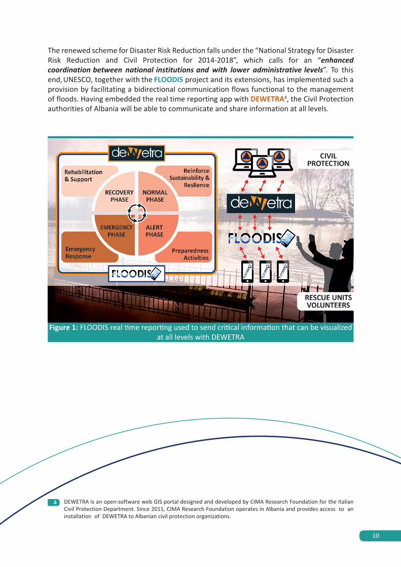
The renewed scheme for Disaster Risk Reduction falls under the “National Strategy for Disaster Risk Reduction and Civil Protection for 2014-2018”, which calls for an “enhanced coordination between national institutions and with lower administrative levels”. To this end,UNESCO, together with the FLOODIS project and its extensions, has implemented such a provision by facilitating a bidirectional communication flows functional to the management of floods. Having embedded the real time reporting app with DEWETRA4, the Civil Protection authorities of Albania will be able to communicate and share information at all levels.
Figure 1: FLOODIS real time reporting used to send critical information that can be visualized at all levels with DEWETRA
DEWETRA is an open-software web GIS portal designed and developed by CIMA Research Foundation for the Italian Civil Protection Department. Since 2011, CIMA Research Foundation operates in Albania and provides access to an installation of DEWETRA to Albanian civil protection organizations.
4

11
1. Assess the capacity to acquire enough information to implement a decision making processusing the DEWETRA platform integrated with the FLOODIS application (situation awareness).2. Assess the capacity to provide short reports through the FLOODIS app, in order to supportthe decision-making process, both with images and written data (real time reporting).
The results obtained demonstrated that, although the existence of a general framework and procedures within which different stakeholders operate, substantial efforts are still required to systematize and clarify roles and responsibilities in emergency management.Standard Operative Procedures for the activation of local assessment teams have been drafted and summarized (full set of SOPs are included in the USB CARD attached to this publication).
2
Alert levels and operational phases in the hydrometeorological Early
Warning System
Numerical Weather Prediction models allow Civil Protection systems to adopt timely measures foreseen in the emergency plan. These actions are intended to reduce the impacts of floods. Currently the Institute of Geosciences, Energy, Water and Environment (IGEWE) dispatches on a daily basis a meteorological bulletin. Despite the limited monitoring network, the bulletin which has been elaborated after analysing numerical weather prediction models (available on DEWETRA), is meant to activate Civil Protection procedures at a National and local levels. The aim of the FLOODIS II project was to analyse the functioning of the Albanian DRR system, focusing on areas requiring urgent interventions. A full scale exercise held in Shkodër, aimed at evaluating the state of the art of flood management at prefectural level, allowed the FLOODIS II consortium partners, along with the active participation of Albanian beneficiaries, to test the various interactions intercurring among different emergency management levels. The exercise was intended to:

12
Activation of operational phases
Given the forecasted criticality provided by the bulletin, a hydrological alert level should be foreseen at Prefectural level. The issuance of an alert level will activate automatically an operative phase as reported in the table below.
The colour code depicted in Table 1 is the same adopted by IGEWE for the issuance of the bulletin. Its thresholds are reported as follows (in Albanian language):
LEGJENDA 1Reshjet 24-orëshe
2.1
Table 1: schematization of the operative chain which initiates the activation of operative phases at local level stemming from the correspondent forecast and
alert level accordingly to IGEWE daily bulletin
Hydrological / Hydraulic forecast (IGEWE)
Correspondent alert level adopted by the Prefecture
Attention
Minimum Operative phase to be adopted by the
entire system Pre-Alarm
GREEN GREEN Ordinary activities
YELLOW YELLOW At least Attention phase
ORANGE ORANGE At least Pre-Alarm phase
RED RED At least Pre-Alarm phase
Table 2: pluviometric alert thresholds accordingly to IGEWE’s bulletin
Niveli i Rrezikut Reshje shiu(mm / 24 orë)
---- nuk priten reshje
i ulët të dobëta (0 – 15)
mesatar mesatare (15 – 45)
i lartë intensive (45 – 90)
shumë i lartë shumë intensive (> 90)
13
1 YELLOW 3 RED2 ORANGE
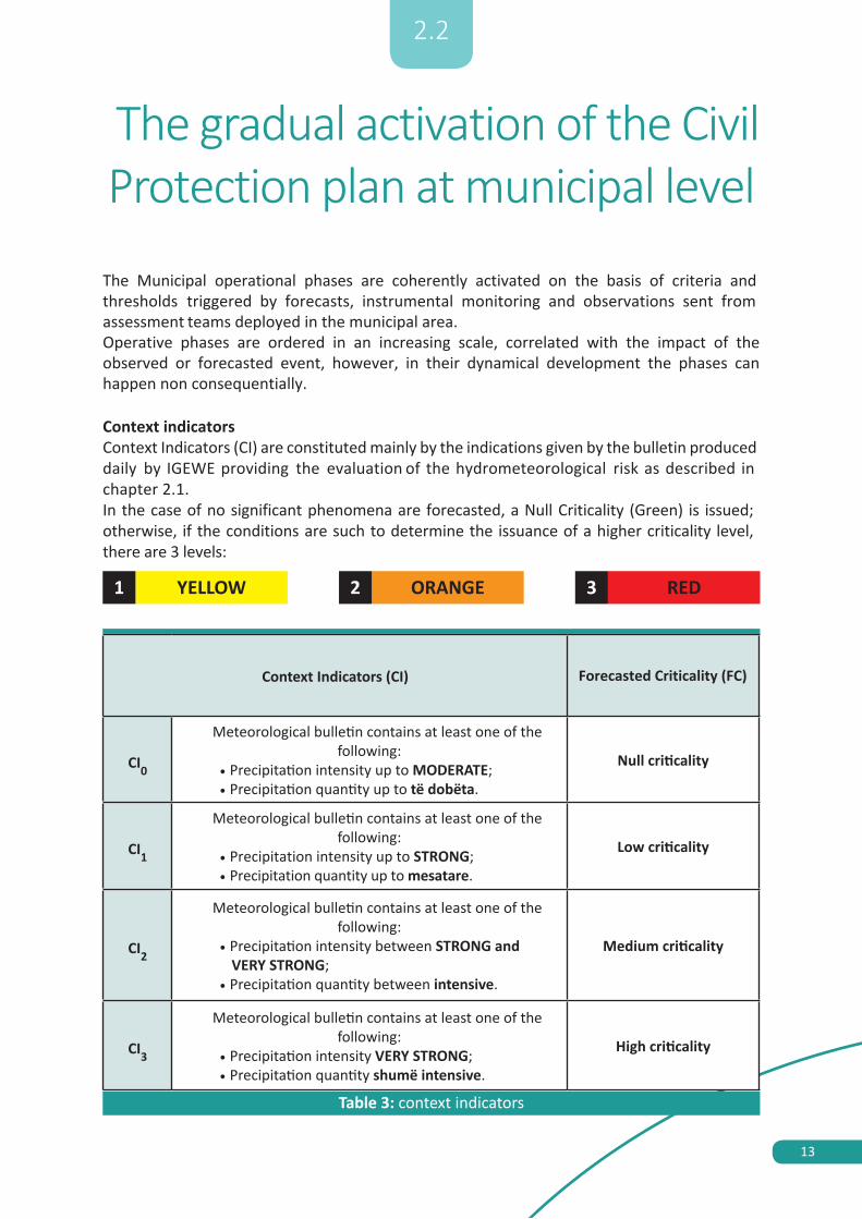
Table 3: context indicators
Context Indicators (CI) Forecasted Criticality (FC)
CI0
Meteorological bulletin contains at least one of the following:
• Precipitation intensity up to MODERATE;• Precipitation quantity up to të dobëta.
Null criticality
CI1
Meteorological bulletin contains at least one of the following:
• Precipitation intensity up to STRONG;• Precipitation quantity up to mesatare.
Low criticality
CI2
Meteorological bulletin contains at least one of the following:
• Precipitation intensity between STRONG andVERY STRONG;
• Precipitation quantity between intensive.
Medium criticality
CI3
Meteorological bulletin contains at least one of the following:
• Precipitation intensity VERY STRONG;• Precipitation quantity shumë intensive.
High criticality
2.2
The gradual activation of the Civil Protection plan at municipal level
The Municipal operational phases are coherently activated on the basis of criteria and thresholds triggered by forecasts, instrumental monitoring and observations sent from assessment teams deployed in the municipal area.Operative phases are ordered in an increasing scale, correlated with the impact of the observed or forecasted event, however, in their dynamical development the phases can happen non consequentially.
Context indicatorsContext Indicators (CI) are constituted mainly by the indications given by the bulletin produced daily by IGEWE providing the evaluation of the hydrometeorological risk as described in chapter 2.1.In the case of no significant phenomena are forecasted, a Null Criticality (Green) is issued; otherwise, if the conditions are such to determine the issuance of a higher criticality level, there are 3 levels:

14
Status IndicatorsStatus Indicators (SI) are derived by the real time observations of the event and of its impacts on the territory as it unfolds. This is done mainly through:
National Weather Stations network and territorial monitoring • Communication of assessment teams deployed in the field• Communication from other institutional stakeholders (I.e. neighbouring municipalities,
Prefecture, General Directorate of Civil Emergencies, etc.)• Population through institutionalized communication channels (emergency numbers)
Such indicators describe the conditions of the territory prior to the happening of the flooding event and should take into consideration the following:
Table 4: Synopsis of State Indicators and correlated criticality level
State Indicator (SI)
Information From Monitoring Network Or Assessment Teams Deployed On The Ground
Criticality(C)
SI1
SI11RAINFALL intensity up to moderate, no thunderstorms, non-stationary (for threshold values see Table 9)
Low criticality
SI12
ON roads: isolated puddles
River beds: base flow discharge
In a covered river: 1/3 of the opening of the covered section
LANDSLIDE: modest presence of runoff waters
SI2
SI21 RAINFALL of high intensity (see table 9 for specific values)
Medium criticality
SI22 Hydrometric levels: rising, reaching the alert threshold
SI23
ON ROADS: runoff waters reaching the tires, ankles of pedestrians, water very turbid
Storm drains obstructed
IN RIVER BED: raising discharge
COVERED RIVER: 1/2 the opening section covered by water
LANDSLIDES: runoff waters and erosion signs
SI3
SI31RAINFALL of very high intensity, persistent and auto-regenerated (see table 9)
High criticality
SI32HYDROMETRIC LEVELS: quickly raising, reaching bankfull levels
SI33
ON ROADS: water at the height of the car body, difficulty walking buoyancy of heavy materials
IN RIVERS: bankfull discharge
COVERED RIVERS: 2/3 of the opening section occupied by water
LANDSLIDES: land movements, roads obstructed

15
Operational phases
The combination of Context (forecasts) and State indicators (observations) determines the operational phase of the Civil Protection System.
Each alert phase activates specific operative procedures within the Civil Protection system at municipal level.Local emergency plans are required to develop standard operative procedures, which can be enacted at each level.Given the fact that the weather station network is unable to provide accurate and geographically precise readings, the importance of municipal assessment teams is even higher for Albanian emergency plans. Their activation and subsequent observations permits the triggering of operative phases in a timely manner. With the support of FLOODIS and DEWETRA, assessment teams will also be able to provide information at Municipal, Prefecture and State level in real time. Consequently, the whole system will be able to monitor the unfolding of events and adopt the necessary countermeasures required in order to mitigate the adverse effects of an emergency.
3
IT IS IMPORTANT TO MENTION THAT THOSE PROCEDURES CANNOT SOLELY RELY ON ICT TOOLS. REDUNDANT SYSTEMS, BASED ON OTHER COMMUNICATION MEANS (I.E. RADIOS OR CELL PHONES), MUST BE ESTABLISHED IN THE CASE OF EVENTUAL FAILURES (NETWORK, ELECTRICITY, IMPOSSIBILITY TO ACCESS PLATFORMS) TO
GRANT CONTINUOUS ACCESS TO INFORMATIONS.
Figure 2: schematization of municipal alert phases
CONTEXT INDICATORS FORECASTS
YELLOW ALERTCI1
RED ALERTCI3
ORANGE ALERTCI2
MU
NIC
IPAL
OPE
RATI
VE
PHAS
ES
ATTENTION
PRE-ALARM
ALARM
LOW CRITICALITYSI1
HIGH CRITICALITYSI3
MED. CRITICALITYSI2
STATE INDICATORS: INSTRUMENTAL MONITORINGAND MUNICIPAL ASSESSMENT TEAMS

16
The information gathered on the ground by the assessment teams are visualized through the DEWETRA platform and transmitted on/using the FLOODIS application. Assessment teams are provided with a supporting fiche (Figure 3) to facilitate the readings and understanding of the situation. Training and frequent exercises are required to instruct both assessment teams and recipients of the information who have to elaborate and instruct municipal stakeholders accordingly.
3.1
Activities of the Municipal assessment teams
In order to ensure extensive monitoring the municipal assessment teams are activated. Their duty is that of surveillance and transmission of relevant information to the EOC of ground effects of areas potentially exposed to meteorological and hydrological risk or affected by localized events. The deployment of assessment teams is triggered by the ATTENTION Operational Phase (see table 5), when teams are notified of a possible activation.
The municipal assessment teams activities are conducted in a dynamic way. According to pre- established routes (to be determined in the planning phase) and control cards (with the same information provided on tablets by FLOODIS - see figure 3 as an example), personnel from the municipality, trained volunteers and other appointed experts use recognizable vehicles if possible equipped with radio and/or telephone communications systems.
The operators of the municipal assessment teams periodically provide the operators of the Emergency Operation Center (EOC) with information regarding their observations.
The table below represents the subjects and the number of teams that perform assessment activities under various emergency operational phases:
Table 5: perform assessment activities under various emergency operational phases
Activities of the municipal assessment
teamAttention Pre-Alarm Alarm Supporting
institutions
Person in the EOC who activates the
teams
Municipal assessment
team No action required
Assessment teams
operating 24/7
Assessment teams,
volunteering organization
and necessary personnel in
support of EOC decisions
Civil Emergency commission established
in the municipality
Member of the Civil Emergency commission
(TBD)

17
Figure 3: control cards for assessment teams

18
Recommendations
The FLOODIS II project identified a set of recommendations on which future initiatives can rely and build on. These take into consideration that the National law on Civil Protection is being revised. Nevertheless, these necessary revisions shouldn’t stop the planning activity which is quintessential for the creation of resilient communities.The following recommendations, discussed with local beneficiaries, identify areas that need urgent attention:
1) Development of Standard Operative Procedures at local level
The lack of SOPs hinders efforts of municipalities to provide a safe environment to citizens and communities. Considering that the disruption of institutional assets as an ordinary event during crisis, the presence of updatable and easy to use (and understand) procedures is a fundamental requirement for the development of a solid and resilient Civil Protection system at all levels. Those procedures are to be operatively tested and adjusted on a yearly basis and should be annexed to the emergency plan of each municipality and administrative unit.
2) Ensure the rapid dissemination of information facilitating the creation ofbidirectional communication flows
The use of DEWETRA and FLOODIS demonstrated how such instruments can facilitate the creation of quick and efficient communication flows. The use of such tools should be inserted into emergency plans and the training of trainers should be organized to ensure that all users are aware of their functioning. Contingency planning must be considered in the event of failure of the systems providing similar information using other tools (i.e. radio).
3) Institute teams of trained volunteers to support municipalities with the monitoringof emergencies
EOC at municipal level is understaffed. Currently, the existence of assessment teams can only rely on the presence of volunteers. However, regulations for their appointment, training and deployment procedures need to be developed and officially adopted. Furthermore, volunteers should be trained in the use of technologies, procedures and on basic emergency management knowledge.
4) Ensure communication amidst neighbouring municipalities and support mechanisms incase of necessity
Communication among neighbouring municipalities within a Prefecture, Region and State is quintessential to reduce and mitigate the impact of natural hazards. A continuous monitoring of the territory and the development of standardized protocols for the transmission of information and the acknowledgment of other institutional stakeholders in the unfolding of events should be ensured.
4

19
5
Conclusions
Technology is now able to provide valuable solutions for environmental monitoring and communication purposes. The FLOODIS II initiative by systematizing information flows and raising situational awareness, created a positive momentum, in this particular transitory period in Albania, when through a participatory process, local authorities are now called to tailor their DRM plans using planning tools and ICT systems. In financial terms, it is acknowledged that FLOODIS application, in particular the real-time reporting module, may considerably decrease the general costs, both direct and indirect, of a flood related hazard as demonstrated by a dedicated Cost-benefit Analysis (CBA) undertaken by FLOODIS project in the aftermath of its testing phase held both in Italy and Albania5. The interoperationalisation with DEWETRA may certainly multiply its impact with the possibility to expand geographical scenarios well beyond the national boundaries of Albania. In the light of the results achieved, UNESCO has for instance, the potential to promote a multistakeholder dialogue on how to close the gap between local governance settings in DRR and the uptake of innovative solutions for real time reporting and situational awareness on flood. This can be now operated by interlinking central based Operation Centres (General Directorate of Civil Emergency) with peripheral ones, which are normally those carrying most of the burdens and impact of hazardous events. Under this light, UNESCO will, therefore, cooperate with CIMA Research Foundation, ISMB, and any other interested National, Regional and International, authority and organization in expanding this combined technologic-governance concept for DRR in the riparian member states of the Drin river basin and beyond. This will be done by facilitating the current efforts of identifying the building blocks for a basin based protocol on local DRR, within which the identified ICT based solutions will find their right place and activation in accordance to the main phases of the DMC. Moreover, considering that DEWETRA is now in use in other European and extra European Member States, such as Barbados, Croatia, Lebanon and Serbia to name a few, this solution could be feasibly extended from national-regional level to a more global scale. .
Finally, the real time reporting function operationalised in FLOODIS II, incorporates major potentialities in becoming a multi-risk applied service, covering other types of hazards such as fire, landslides etc., if enhanced with specific and innovative follow ups. The case in point is represented by the on-going H2020 project I–REACT, (Improving Resilience to Emergencies through Advanced Cyber Technologies)6 in which UNESCO is involved as consortium partner and leader of the Regional and International Cooperation Work Package. I-REACT (led by ISMB) is a living legacy of FLOODIS, leveraging on crowdsourcing assets and developing social media, smartphones and wearables derived solutions to tackle multiple risks and natural disasters in their entire DRM cycle. Coping with increasingly impacting hazards, compels us all to a relentless engagement on coalescing technological, institutional and financial resources in order to develop innovative solutions and foremost to turn them into resourceful, well-tailored and resilient working tools at the service of our member states’ decision makers, emergency managers, professional volunteers and citizens.

20
http://www.i-react.eu/6
5 Alpha Consult undertook a CBA (cost benefit analysis) applied to a “business case” derived by the flood emergency which stroke SEE countries and Albania in February 2015. The analysis, validated by the General Directorate for Civil Emergencies, considered savings generated by the adoption of FLOODIS solution in the DRM cycle towards two main target beneficiaries: the GDCE in relation to their internal emergency management cost reduction; the larger public in relation to multi-assets and economic damage reduction. According to the analysis, the GDCE could have saved about €80,000 in terms of internal emergency management costs. However, benefits for the broader public and infrastructural asset domains would have been substantial higher. For instance, the reduction of costs for affected people could have been of c. €15m (considering an estimated 10% decrease of the number of injured, affected and homeless people and a cost of c. €3,600 for each affected person, as suggested by the General Director of Civil Emergencies). Furthermore, considering c. €11m the estimated impact of the occurred flood to the Albanian infrastructures, an overall c. €330,000 would have been the benefit scenario upon FLOODIS service activated and running. Finally, c. €550,000 of damages to productive sector (mainly agriculture), and c. €170,000 to social sector could have been both averted. These estimates must be taken as only a rough indication of what might be the impact of a thorough implementation of real time reporting and environmental monitoring services, such as FLOODIS-DEWETRA solutions as hereby explained.

Find out more at
The herewith-enclosed USB CARD www.floodis.euwww.i-react.eu