Embed Size (px)
Citation preview

This issue marks the 10th anniversary of Flood Lines! Thank you to all our subscribers and readers! We hope you have found this newsletter helpful over the years. As always, we appreciate any comments or feedback you may have about Flood Lines.
Flooding is the most common disaster
event in New Hampshire. The purpose
of Flood Awareness week is to encour-
age all residents to prepare their homes,
communities and businesses for flood-
ing events. This is a time for individuals,
families, businesses and communities to
understand their risk for flooding and
take precautions to protect their fami-
lies and homes in the event of flooding.
In support of Flood Awareness Week, the OEP Floodplain Management Program has
created a Flood Awareness web site, which includes an outreach toolkit that con-
tains a flood facts flyer, sample social media messages, and a sample press release.
Communities and other interested parties can use this toolkit to help spread the
word about being aware and prepared for flooding.
OEP will also be sending out flood awareness and preparedness messages during
this Flood Awareness week through Twitter and the Flood Lines email distribution
list.
I n s i d e t h i s i s s u e :
Insurance Update
2
Mapping Update
3
Community Rating System Update
4
Training & Events
6
Flood Lines V o l u m e X I s s u e 1 W i n t e r 2 0 1 7
NH Office of Energy &
Planning
107 Pleasant Street
Johnson Hall, 3rd Floor
Concord, NH 03301
Phone: 603-271-2155
Fax: 603-271-2615
www.nh.gov/oep/
planning/programs/
fmp
Happy 10 Years Flood Lines!
NH Flood Awareness Week - March 20 - 24, 2017
Flooding in Raymond in April 2007 Photo by: Jennifer Gilbert

2
FEMA Sending Letters to Policyholders to Clearly
Communicate Flood Risk FEMA has begun the next phase of implementation of Section 28, Clear Communi-
cation of Risk, of the Homeowner Flood Insurance Affordability Act (HFIAA) of 2014,
which requires the agency to clearly communicate full flood risk determinations to
individual property owners.
To meet this requirement, the National Flood Insur-
ance Program (NFIP) reviewed the flood risk and
underwriting information for every flood insurance
policy, and is writing to all NFIP policyholders to ex-
plain the current risk level for their property and the
relation of the risk to their premium rates.
Starting January 2017, policyholders began receiving
letters about two months after their policy renews.
Policyholders who renewed policies in October 2016
through December 2016 received their first mailing.
FEMA will continue to mail the letter at each subse-
quent renewal. Because policy information varies
from one policy to the next, the letters encourage
policyholders to contact their insurance agent to
discuss their unique situation, or visit FEMA’s Cost
of Flood web site to learn about their options.
All policyholders will eventually receive a letter up-
on the renewal of their policy. The NFIP has identi-
fied seven categories of policyholders to receive
unique information based on their risk and current premium rates.
HFIAA requires gradual insurance rate increases for properties currently receiving artificially low (or subsi-
dized) rates, rather than immediate full-risk rate increases. HFIAA requires increases to premiums for most
subsidized properties of no less than 5 to 15 percent annually, but no more than 18 percent for an individual
policyholder--with limited exceptions--until the premium reaches its full-risk insurance rate.
The information that NFIP policyholders will receive, will help them make the best decisions about their flood
risk, including how to better prepare for flooding disasters in their community. Source: ASFPM Bi-Monthly Newsletter for Chapters—Feb. 2017
Insurance Update
3
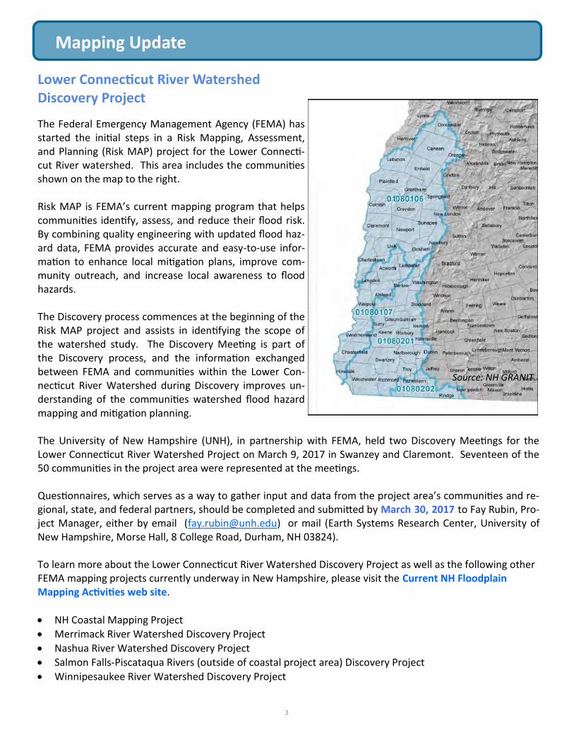
Lower Connecticut River Watershed Discovery Project
The Federal Emergency Management Agency (FEMA) has started the initial steps in a Risk Mapping, Assessment, and Planning (Risk MAP) project for the Lower Connecti-cut River watershed. This area includes the communities shown on the map to the right. Risk MAP is FEMA’s current mapping program that helps communities identify, assess, and reduce their flood risk. By combining quality engineering with updated flood haz-ard data, FEMA provides accurate and easy-to-use infor-mation to enhance local mitigation plans, improve com-munity outreach, and increase local awareness to flood hazards. The Discovery process commences at the beginning of the Risk MAP project and assists in identifying the scope of the watershed study. The Discovery Meeting is part of the Discovery process, and the information exchanged between FEMA and communities within the Lower Con-necticut River Watershed during Discovery improves un-derstanding of the communities watershed flood hazard mapping and mitigation planning. The University of New Hampshire (UNH), in partnership with FEMA, held two Discovery Meetings for the Lower Connecticut River Watershed Project on March 9, 2017 in Swanzey and Claremont. Seventeen of the 50 communities in the project area were represented at the meetings. Questionnaires, which serves as a way to gather input and data from the project area’s communities and re-gional, state, and federal partners, should be completed and submitted by March 30, 2017 to Fay Rubin, Pro-ject Manager, either by email ([email protected]) or mail (Earth Systems Research Center, University of New Hampshire, Morse Hall, 8 College Road, Durham, NH 03824). To learn more about the Lower Connecticut River Watershed Discovery Project as well as the following other FEMA mapping projects currently underway in New Hampshire, please visit the Current NH Floodplain Mapping Activities web site. NH Coastal Mapping Project Merrimack River Watershed Discovery Project
Nashua River Watershed Discovery Project Salmon Falls-Piscataqua Rivers (outside of coastal project area) Discovery Project
Winnipesaukee River Watershed Discovery Project
Mapping Update
Source: NH GRANIT
4
2017 Edition of CRS Coordinator’s Manual is on the Way
The CRS is anticipating the release of an updated version of the CRS Coordinator’s
Manual any day now. The draft document is undergoing final review at the Office of
Management and Budget (OMB); when OMB issues its final approval, the new Coordi-
nator’s Manual will be available for download on the CRS Resources web site.
There will be no major changes in the 2017 Coordinator’s Manual. Instead, you will find multiple improve-
ments, clarifications, and minor corrections. None of this will require substantive changes to a community’s
CRS program or procedures. Some of the 2017 changes are discussed below.
Remember . . .
Communities do not need to change their preparation for the next verification visit. Coverage under the
new edition will be phased in and the ISO/CRS Specialist will work with the community to spot any differ-
ent documentation or other changes that will apply in the future.
Changes from previous editions will be marked with vertical bars in the margins of the pages. This will
help you spot places that you may want to review, to see if the change affects your community.
More about What’s New
The 2017 Coordinator’s Manual establishes a sea level
rise standard for crediting communities that assess
and manage the changes anticipated from changing
sea levels. The CRS has chosen to require, at a mini-
mum, that communities use the “intermediate-high”
projection for 2100, from the report Global Sea Level
Rise Scenarios for the U.S. National Climate Assess-
ment. Website links and instructions for determining
the sea level rise for a community will be available on
the CRS Resources web site.
Coastal communities are being provided with more options for watershed management planning credit
under Activity 450. Credit will be available for watershed plans that assess the impacts of climate change
and sea level rise on the local drainage system. This allows a coastal community that has a non-traditional
watershed (no natural or constructed channels), but is nonetheless threatened by flooding because of a
rise in sea level to receive credit for evaluating its sea-level-related flood problems without a “model” of
the watershed. This addition reflects the fact that increasing numbers of communities are taking action to
mitigate the effects of a changing climate and rising sea levels, and that federal initiatives like that of the
Corps and NOAA (see previous bullet) have made such actions feasible.
(continued on page 5)
Community Rating System (CRS) Update
Flooding in Hampton during 2016 King Tide Photo by: Kellie Walsh

5
Community Rating System (CRS) Update (continued)
CRS Category C repetitive loss communities are being re-defined as those with 50 or more repetitive loss
properties. Under the 2017 definition, there will be fewer Category C communities. The 2017 Coordina-
tor’s Manual clarifies that Category C communities must either prepare and adopt a Repetitive Loss Area
Analysis (RLAA) for all repetitive loss areas, or prepare and adopt a floodplain management plan (FMP)
that includes a problem assessment of all repetitive loss areas and a review of flood insurance claims. You
can find details about the FMP planning in Section 512.a of the 2017 Coordinator’s Manual, and about the
RLAA in Section 512.c. Going forward, all Category C communities that do not produce a RLAA will have to
earn full credit in Planning Step 5(c) for FMP.
Your ISO/CRS Specialist will work closely with your community to explain what is required in your particular
situation.
Source: ASFPM Bi-Monthly Newsletter for Chapters—Feb. 2017
Upcoming CRS Webinars
Below are some of the upcoming CRS online webinars, which all begin at 1 pm. Many of the courses are eligi-
ble for Continuing Education Credits (CECs) for Certified Floodplain Managers (CFM). For registration and
more information, please the NFIP Training Webinars section on page 6 of this newsletter.
Preparing for a Verification Visit (March 21)
Changes in the 2017 Coordinator’s Manual (March 22)
The Role of the Community CRS Coordinator (April 18)
Repetitive Loss Properties and the CRS (April 19)
Introduction to CRS (May 16)
CRS and Coastal Hazards (May 17)
Congratulations to the City of Nashua becoming NH’s 5th CRS Community! Effective May 1, 2017 the City of Nashua will officially become a Community Rating System (CRS) Class 8 community. This will result in a 10% premium discount on flood insurance for most flood insur-ance policy holders in Nashua. Madeline Mineau, Waterways Manager, is Nashua’s CRS Coordinator. Nashua will become the fifth community in New Hampshire to participate in CRS. Nashua joins Keene and Peterborough, who are also CRS Class 8 communities, and Marlborough and Winchester, who are CRS Class 9 communities. To learn more about CRS, please visit OEP’s CRS web site.

6
Training and Events
2017 Rhode Island Flood Mitigation Association Conference
Thursday, April 6, 2017 - 8:00 am to 4:30 pm in Smithfield, RI
This year’s conference theme Building Flood Resilience…Naturally will focus on the use of natural and nature-based infrastructure for enhancing flood resiliency. Join floodplain management and hazard mitigation professionals as we share ex-periences and lessons learned. For more information including registration and draft agenda, please go to RIFMA’s web site. Pending 6 CFM and APA credits.
Surveying in Floodplains
Wednesday, May 10, 2017, 9:30 am to 4:00 pm at UNH Manchester
This workshop will cover a general overview of floodplain management and the NFIP. Attendees will receive
guidance, helpful tips and handouts on how to review, use, and revise floodplain maps, how to comply with
the NFIP Floodplain regulations, and how to minimize the cost of flood insurance. Additional information
about registration and fees can viewed on UNH Manchester’s web site.
NFIP Online Training Webinars
Numerous free, online NFIP-related trainings are available through FEMA’s contractor, STARR. Many of the
courses are eligible for Continuing Education Credits (CECs) for Certified Floodplain Managers (CFM). Be sure
to check the website periodically as new webinars are always being added. To learn more about these webi-
nars and to register, please go to the NFIP Training web site and click the “Upcoming” tab. When asked dur-
ing registration what FEMA Region you are in, please reply 1.
Below are some of the upcoming webinars, which all start at 1 pm.
How to Review a “No-Rise” Certification (March 30)
Effective Public Engagement through Mitigation Planning (March 31)
Elevation Certificates (April 6)
Tools for Determining Base Flood Elevation (April 13)
Developing FEMA Mitigation Planning Grants (April 21)
Floodplain Development Permit Review (June 22)
Inspecting Floodplain Development (June 22)
Jennifer Gilbert, CFM, ANFI Kellie Walsh, CFM State Coordinator Assistant Coordinator [email protected] [email protected] 603-271-1762 603-271-1755
New Hampshire Office of Energy & Planning 107 Pleasant Street, Johnson Hall, 3rd Floor, Concord, NH 03301
(603) 271-2155 Phone (603) 271-2615 Fax Web Site: www.nh.gov/oep/planning/programs/fmp/
New Hampshire Floodplain Management Program Contact Information