Embed Size (px)
Citation preview

The Black Sea,the Flood and
the Ancient Myths
Varna, 2004
Petko DimitrovDimitar Dimitrov

CONTENTSPreface .............................................................................................. 5
Introduction ....................................................................................... 6
Chapter 1The Black Sea – What Do We Know About It? ................................. 9
Chapter 2Geocatastrophic Events in the Black Sea .......................................... 19
Chapter 3Hydrogen Sulfide – the Curse of God ............................................... 31
Chapter 4The Black Sea Coast and Shelf – a Centerof Flourishing Pre-Flood Civilizations ............................................... 45
Chapter 5Names of the Black Sea .................................................................. 53
Chaptar 6The Black Sea – a Key to the Mystery of the World Flood............... 60
Chapter 7The Sumerian Epic and the Bible Myths ........................................... 71
Conclusion ...................................................................................... 86
This book we dedicate toour inspiration Natalya.
The authors
© AUTHORS: PETKO DIMITROV; DIMITAR DIMITROV
© TRANSLATOR: DIMITRINA CHONKOVA
© EDITOR: DELCHO SOLAKOV
© PROOFREADER: PROF. RICHARD THOMAS
© ARTIST: BONO SKODROV
© PREPRESS AND PRESS “SLAVENA”ISBN 954-579-335-X
All rights reserved. No part of this publication may bereproduced, stored in a retrieval system, or transmitted in anyform or by any means, electronic, mechanical, photocopying,recording or oherwise, without the prior written permission of
autors or publisher “Slavena”, Varna, Bulgaria.

5
PREFACE
It is with pleasure that I write a preface to the English version of thisbook, “The Black Sea, the Flood and Ancient Myths.” It was originallywritten in Bulgarian by the distinguished father and son team ofoceanographers, Petko and Dimitar Dimitrovi, and it is a major contributionto our understanding of both human evolution and the recent geologic past.Its importance is emphasized by the authors’ insight into the mythologysurrounding the Great Flood and the elegant convergence of the myth withscientific facts and observations which, as a totality, has provided these twoeminent scientists with an insight into one of the greatest events ofcatastrophic proportions to befall mankind.
The authors have provided a careful analysis of the mythology,archeological evidence and geological evidence, offering a compelling casefor the existence of an early lake, its influence on the associated settlementsthat existed on the current shelf of the Black Sea, and the subsequent floodingof the Black Sea through the Bosphorous. This marine flooding is a fact andthe sequence of events is well accepted. However, as with all advances inscientific knowledge, there are those who do not accept the proposition ofTHE FLOOD as promulgated in this dissertation. In any scientific endeavor,there are always some facts that can be disputed or challenged. However,it is the totality, the meshing of scientific evidence with mythology, thatleads to the insight required for resolving problems raised by past events.Continued scientific study of the region will provide further evidence thatthe interpretations enunciated in this book are valid. This is the way ofscience, and it is clear to me that this book will serve as a guide and inspirationfor many investigators to come.
Non-technical readers will not be overwhelmed by the science containedin this book. It is concise and readable, and it is a wonderful story of scientificinvestigation illuminating the mysteries of the past.
Richard L. Thomas

6 7
IntroductionIs it possible that the Black Sea was the site of the Biblical Flood? It is
true that today this hypothesis is questionable but have we really gonethrough all the pages of the newest history of the earth and world civiliza-tion?
Until recently, the interpretation of the Biblical events has been the ex-clusive domain of theologians. If other scientists discussed the subject andundermined postulates, they were accused of sacrilege. Modern Biblicalarchaeology argues that it has answered the questions concerning the tim-ing and site of the Flood.
Our knowledge of the world as acquired from either the Bible or fromthe Sumerian Epic, is confined to the regions of the rivers Tigris, Euphratesand Nile. In the Sumerian Epic, the hero Gilgamesh walked through the“Sea of Death” in search of eternal life. Where was this sea? The DeadSea, the Red Sea, the Mediterranean Sea, the Black Sea and the CaspianSea are each a potential site of the Flood.
Explorations in Mesopotamia and the Red Sea, the tablets with theSumerian Epic in Nineveh, the manuscripts of the Bible and a number ofother findings gave sound grounds to recognize the Tigris-Euphrates areaas the place of the Flood. The interpreters of the Bible and the theologiansengaged in archaeological explorations had no idea about the magnitudeof natural disasters. The recent contributions of geologists to the explana-tion of these events have led to a significant turn in the interpretation of therecords about the Flood and to a revision of the existing concepts. It wasproved that the civilizations of the ancient world, Mesopotamia, Egypt,Crete and Greece, India and China, originated from a single point. Thisuniform origin is confirmed by the structure of their rituals. The results fromthe comparison between the different ancient languages are also compel-ling evidence.
The widely accepted view that the oldest traces of writing date to ap-proximately 3,000 BC seems to be rejected because of the proof of theexistence of antediluvian writing. Harald Haarmann1, argues that the old-
est writing in the world was found in the Balkan Peninsula. He dates theTartaria tablets as being from 5,300 BC.
Almost all scientists who have studied the Bible and the Gilgamesh epicare unanimous in evaluating those writings as a valuable source of informa-tion. However, none of the works indicates the location of the Flood. Thereal story of the beginning has been lost in time and space. This gives us areason to look for new facts which will shed more light on the missingpages of world history.
The critical analysis of ancient myths and the new geological and ar-chaeological facts about the Black Sea basin are about to break the dog-ma and add a new meaning to the Biblical myths.
Significant discoveries by Bulgarian archaeologists including the Neolith-ic2 necropolis of Varna and Durankulak (where the oldest processed goldin the world was found) gave rise to a number of questions, the mostinteresting of which is the question about the importance of the “Varna”culture in human history. The definition of Varna culture as an “unrealizedcivilization” is not relevant to the new facts about the existence of the an-cient Neolithic culture throughout the Black Sea coast and shelf.
William Ryan and Walter Pitman’s book “Noah’s Flood” and the BBCfilm “Noah’s Flood” caused a scientific sensation at the end of 2000. Thebook is a brilliant combination of scientific arguments from nearly all fieldsof science united in a single geographical center – the Black Sea. Thefollowing statement by the famous deep-sea explorer, Dr. Robert Ballard,illustrates the enormous interest in the arguments exposed by the Ameri-can scientists:
Noah’s Flood” is a fascinating scientific-detective story. It must be read!Undoubtedly, this book will provoke a number of expeditions for findingevidence which will prove or disregard the hypothesis.”
Dr. Ballard has already tried his luck as a discoverer working in theBlack Sea in the region of Sinop, Turkey in 1999 and 2000. The results ofthis expedition are well-known today. In 2001 and 2002 Ballard and histeam, together with Bulgarian scientists, continued to search for new sites

8 9
in the western Black Sea. The main purpose of the exploration was toseek for artifacts along the old shorelines – remains of ancient settlements.
Our book was planned 20 years ago, when persuasive geological ev-idence that the Flood did occur, was presented. It lays the foundations ofan interdisciplinary science – geo-archaeology. The book is written basedon numerous facts gathered by the authors during many years of expedi-tions and explorations. The newest ideas on the geo-historical develop-ment of the Black Sea basin are presented.
The text and the figures of this book are prepared with the assistanceof the staff members from the Marine Geology and Archaeology Depart-ment – Delcho Solakov, Veselin Peichev, Preslav Peev and NedialkaChonkova and the artist - Bono Shkodrov. We also received strong sup-port from Dr. Todor Dimov – the head of the excavations at the ancientsettlement and necropolis in Durankulak.
We would like to express our gratitude for their invaluable help andsupport.
Chapter 1The Black Sea – What Do We Know About It?
The Black Sea lies at latitude 40o 55’ 5’’ to 46o 32’5’’ north and atlongitude 27o 27’ to 41o 42’ east in the moderate climatic zone. To thenorth, the Krechenski strait connects the Black Sea with the Sea of Azovwhich is regarded as a bay.To the south, the Bosporus and the DardanellesStraits connect it with the Marmara Sea and the Aegean Sea (fig.1). Thetotal area of the Black Sea is approximately 423,000 km2, and togetherwith the Sea of Azov the area reaches to 460,000 km2. The greatest lengthis 1,149 km and the greatest width 611 km. The maximum depth of thebasin is 2,245 m, and the average depth is 1,271 m. The abyssal bottomoccupies about 37% of the total Black Sea area, the continental slope34% and the shelf 27%. The area of the Exclusive Economic Zone of theRepublic of Bulgaria in the Black Sea is about 33,800 km2. The totalvolume of water is 537,000 km3 of which the waters of the oxygen zoneoccupy only 10%, the other 90% being taken up by deep oxygen-freewaters.
The Black Sea is an inland sea with all the typical features of the oceanwater areas – significant depth, extensive alluvial inflow and inflow of theworld ocean waters. This greatly influences the pattern of present naturalprocesses in the basin.
The water masses of the Black Sea are generated from continentalinflow, precipitation, the Marmara Sea and the Sea of Azov waters. Thelargest inflow is from the Danube river– 70% of the total continental in-flow. The water exchange with the Marmara Sea is extremely importantfor the hydro-biogeochemical regime of the Black Sea. It is a well-knownfact that the Black Sea level is about 35-50 m higher than the level of theworld ocean and the Mediterranean Sea and that the water surface of theBosporus slopes towards the Marmara Sea. The balance of water ex-change between the Black Sea and the Marmara Sea through the Bosporusis a key factor that defines the vertical distribution of the salinity and den-sity of the water masses. The modern structure of the Bosporus currents is

1 0 1 1Fi
g.2.
A p
rinci
ple s
chem
a of t
he w
ater
exch
ange
bet
wee
n th
e Bla
ck S
ea an
d th
e Mar
mar
a Sea
two-layered. The surface Bosporus current exports waters with salinity of17-18‰ from the Black Sea to the Marmara Sea. The thickness of thelayer varies, depending on the season, from 20 to 40 m. Under this boundarypasses a bottom Bosporus current that imports Marmara Sea waters with38‰ salinity into the Black Sea. It results from the different water densityof the two seas. The velocity of the surface current under normal meteo-rological conditions reaches up to 1,5m/s, while the bottom current ve-locity is 0, 75 m/s. Fig. 2 shows a scheme of water exchange between theBlack Sea and the Marmara Sea. About 340 km3 of water annually flowsinto the Marmara Sea from the Black Sea through the Bosporus, whileabout 180 km3 of Marmara Sea waters flow into the Black Sea. Thismeans that if the Bosporus sill had been blocked, the Black Sea levelwould have risen 0, 5 m annually. The volume of the Mediterranean Seawaters today is 3, 7.106 km3, and the evaporation surpasses the volume ofprecipitation by 3.103 km3 per year. These calculations show that if the Straitsof Gibraltar had been blocked, the Mediterranean Sea would have beendry for up to 1,000 years. Only for the formation of the Messinian evapor-ites3 5, 5 million years ago, the Mediterranean Sea must have dried upabout 40 times.
The deep Black Sea trough came into being as a result of comparative-ly fast negative tectonic movements. This process went through differentstages and it was most intensive at the end of the Oligocene4, 25 millionyears ago. Later, during the Pliocene5 and in the beginning of the Pleis-tocene6, the activation of the tectonic movements caused deepening andreformation. After its creation, the deep trough gradually filled in with sed-iments up to 14 km thick, according to seismic data. These sedimentshave covered the age range from the Paleozoic era7 to the present day.The geological history of the Black Sea was particularly dynamic duringthe last two million years. During the period of continental glaciations, theBlack Sea became a landlocked freshwater lake, whereas during the in-terglacials, it restored its connection with the world ocean through theBosporus.
The Black Sea climate is exceedingly specific and it is formed by the

1 2 1 3
and structure. This process is extremely complex under natural conditions,especially in the uppermost part of the underwater slope, where the final
Fig.
3. S
chem
atic
geo
logi
cal c
ross
-sec
tion
of th
e she
lf an
d th
e maj
or el
emen
ts o
f the
relie
fQ
1 -Q
IV –
qua
tern
ary
depo
sits
N2
– Pl
ioce
neC
2 –
Upp
er C
reta
ceou
s vol
cano
geni
c-se
dim
ent r
ocks
impact of three major components: European-continental influence fromthe North, Mediterranean from the South and its own Black Sea influ-ence. On the basis of the components stated above, the Black Sea isreferred to as a moderate-humid climatic zone.
The total water area of the Black Sea basin amounts to 1,875 million km2,the rocks being the main source of terrigenous material8 that is importedinto the Black Sea. About 27, 4 million m3 per year of silt enters the seafrom the abrasion of the shores. The rivers Dniester, Dnieper, Bug andDanube are the most important sources of terrigenous material. Annually,these rivers deliver about 88,100,000 t solid material, most of which sili-cates; the carbonates are 25,000,000 t.
The Danube River has the largest solid material inflow – 83,000,000 t. Thepattern of contemporary circulation of water masses is as follows: the enor-mous volumes of silts from the above mentioned rivers, mainly the DanubeRiver, spread along the length of the western shelf, thus causing high ratesof sedimentation. In terms of alternating regressions and transgressions inthe basin during the last two million years there occurred a periodic changeof the areas with manifestation of different hydrodynamic factors. In somecases their movement is offshore; in others it is onshore. It has been al-ready determined that the shelf was dried up several times during the gla-cial regressions and the sea level was lower than the contemporary one,reaching depths of 90-120-170 m. At regression or transgression the un-derwater slope is processed by the wave motion under surf zone condi-tions, and then it is drowned at transgression or re-emerges as a sub-aerialenvironment at regression.
In the coastal (inland) area of the shelf (fig. 3), at low water depths,where the waves are transformed, (i.e. they are deformed and broken, aprocess of re-distribution of the wave energy) high water turbulence9 oc-curs. Here the hydrodynamic regime is most active and depends on thewave motion and the arising currents which might be parallel or vertical tothe shore (energetic, gradient, and compensatory). Differentiation, sus-pension and combination of sediment material take place in the surf zoneas a result of the wave motion and, depending on its intensity, direction

1 4 1 5
the shelf dynamics of tideless seas. The hydrogenous forms of the reliefare oriented in the direction of the main stream of the major Black Seacurrent.
The transition from the shelf to the continental slope is an area withmanifestation of intensive hydrodynamic processes, determined by addi-tional hydrodynamic and hydro-chemical factors. The hydrodynamic trans-fer of sediment material, which is carried out in the form of the so-calledcontour currents, is typical for this zone. These currents create naturalfurrows, through which the organogenetic-mineral material flows in thedirection of maximum velocity of the seafloor currents.
Seafloor forms, oriented towards the axis of the main Black Sea cur-rent, still occur in the zone of the outer terrace (105-110 m).
A process of mass transfer of sediment material by dragging and sal-tation in the direction of the isobaths is observed down the slope (below110 m). The quantity of the suspended sediment material is significant,that is why the water-bottom boundary is difficult to observe in the lightsof the submersible.
It is known that the continental slope is furrowed by an alluvial fansystem, which is characterized by specific hydrodynamic regime (fig. 4).In 1983, when exploring the Rezovska underwater valley to a depth of970 m, in the seafloor layer the currents were measured with an RCM-4instrument. The results showed that in the valley axes the current velocityranges from 1-2 to 10 cm/sec. Drilling determined that contemporary andHolocene sediments were missing in frequent places in the axes and theslopes of the valleys, especially where the slope of the bottom is steeper.Similar data was observed when exploring the Varna canyon to depths of500 m by the manned submersible “Argus” in 1985. Active slides of Ho-locene sediments (sapropels13 and coccolith silts) along the surface of theunderlying dense Neoeuxine14 silts are observed in the axis of the valley(fig. 5). When the submersible even slightly touched the bottom, a sus-pended flow was formed, which spread down the slope as a smokescreen.It is obvious that the gravitational slides and turbidity currents15 are com-mon phenomena in this zone.
breaking of the waves occurs.In the central area of the shelf (fig. 3), where the direct energetic impact
of wave motion on the bottom is minimal, drift currents are key relief-forming factors. The normal direction of the main stream of the currents isnorth-south, which determines the transportation of terrigenous materialfrom the Danube River and its deposition in the central accumulative shelfplain. The so-called compensatory currents at the bottom are typical. Theyare directed opposite to the surface current and often cause acceleratedsedimentation. They are genetically related to the coastal zone; howeverthey spread to bigger depths, especially at a time of extreme storms.
High rates of sedimentation and considerable thickness of the Ho-locene10 sediments are typical for the coastal and central part of the shelf.Alongside the shore, crossed the old deltas of the rivers forming broadalluvial plains. They deposited continental alluvial and lake-swamp sedi-ments (stripe-like ooze).
In the shelf periphery (fig. 3), in the area of the old shorelines, at 80-100-120 m, the sediment formation is insignificantly influenced by the wavemotion. The most important factors for this process are the turbulence andbottom currents, resulting from the so-called internal waves. Due to theirgreat length (ranging within hundreds of meters), the internal waves aredeformed in the edge area of the shelf. The several cm/sec velocity of themovement of these waves is sufficient to keep the aleurites11 and pelites12
in suspension and to provide for their transportation to deepwater areas.This mechanism is one of the possible explanations for the deviations fromnormal mechanical differentiation of the shelf periphery.
According to existing data the deviations can result from the presenceof older deposits, relics from the old shorelines. The instrumental mea-surements of the currents and the visual survey carried out by the mannedsubmersible PC-8 in the areas of erosion or zero sedimentation indicate avelocity from 50 to 80 cm/s. This shows that the sediment material is trans-ported and deposited out of this zone.
The hydrogenous transfer of sediment material (isobaths) dominatesover the gravitational transfer (offshore). This is typically characteristic of

1 6 1 7
Fig.
6. N
atur
al an
d an
thro
poge
nic f
acto
rs fo
r the
form
atio
n of
the c
onte
mpo
rary
Bla
ck S
ea re
gim
e
The gravitational microforms created as a result of the movement offriable deposits down the slope are widely spread on the continental slope.They are seen as a number of forms of fractures and slides. There areoccurrences of long synclinal tracks, along which turbidity currents move.Brecciaing16 processes are developed in large scale at the foot of the con-tinental slope and abyssal bottom. Signs of turbidity currents are observedalong the surface of the bottom.
Active hydrodynamic processes play an important role in the origin,transportation and deposition of sediments on the shelf. On the continentalslope and abyssal bottom they are determined by turbidity currents, grav-itational sliding and brecciaing.
The presence of a deepwater hydrogen sulfide layer at depths of130-200 m is a typical characteristic of the Black Sea. Therefore, theupwelling phenomenon is especially significant for explaining changes inchemical and biogeochemical processes.
Upwelling is the vertical motion of water by which hydrogen sulfidewater of higher salinity and rich in biogenic components moves toward thesurface of the ocean. Upwelling results when winds blowing nearly parallelto a continental coastline transport the light surface water away from thecoast. Subsurface water of greater density and lower temperature replac-es the surface water and exerts a considerable influence on the weather ofcoastal regions.
North-east winds (35-40% of the annual direction) are predominant inthe Black Sea with south-west and western accounting for 25-30%. Theupwelling occurs under the impact of the south-west winds. According toour observations, it is particularly intensive in the water area of the westernBlack Sea and significantly stimulates biogenic and terrigenous sedimenta-tion.
The hydrogen sulfide contamination is an extraordinary phenomenon,which distinguishes the Black Sea from other seas and oceans. The oxy-gen zone occupies the upper layer to depths of 120-150 m. The thicknessof this layer varies in different regions of the sea depending on currents,meteorological environment, etc.

1 8 1 9
Chapter 2Geocatastrophic Events in the Black Sea
The modern geological history of the earth is characterized by alterna-tion of striking geocatastrophic events. Continental glaciations and inter-glacial epochs and the related transgressions and regressions of the worldocean and landlocked seas have created the appearance of the planet.During the last 1, 7 million years there have been four glaciations on theEarth – Gunz17, Mindel18, Riss19 and Wurm20 - with their respective inter-glacial epochs. These processes were most complicated in the East Med-iterranean region which covers the Mediterranean, the Black Sea and theCaspian Sea (fig. 1)
What was the succession of events in the Black Sea according to thenewest data? At the Pliocene-Pleistocene boundary regression took placein the Black Sea, simultaneously with the Late-Calabrian regression in theMediterranean under glacial Gunz conditions approximately 1, 7 millionyears ago. The Black Sea level reached to 170 m below the contempo-rary sea level (fig. 7). This data was discovered in 1982 when we weredragging the bottom with the research ship Explorer 2. Shore boulders21
and gravel pieces, smooth and highly lithified with Pliocene and LowerPleistocene (Gurian) fauna22, were extracted from the continental slope ata depth of 170 m.
Later, the Lower Pleistocene (Chaudian) shoreline, which was formedduring the Gunz-Mindel interglacial, was exposed on the periphery of themodern shelf at depths of 80-100 m. Pebble-gravel deposits, often lithi-fied (fig. 8 a, b, c) fix the shoreline all over the periphery of the wholeBlack Sea basin. The saline Chaudian basin occupied the water area ofthe Black Sea and the Marmara Sea, as well as the eastern part of theAgean Sea. The discovery of Upper Pliocene and Lower Pleistocene de-posits on the shelf and the continental slope of the Black Sea created asensation among scientists because, up to then, it had been thought thatthese deposits formed the high 90-100 m terraces along the coast. TheLower Pleistocene, which spanned from 1, 7 million to 440,000 years
The so-called intermediate or redox layer (fig. 6) – a layer of mutualexistence of hydrogen sulfide and oxygen - is located under the oxygenzone. Intensive processes of chemical and biological oxidation of com-pounds from the hydrogen sulfide zone, created as a result of bacterialanaerobic decomposition, take place in the redox layer.
In relation to the concept of a “disastrous” rise of the hydrogen sulfidelevel, it can be said that the location of the upper boundary changes overquite a large range. In the central part of the Sea, it has created an irregularprotuberance, which reaches to 80-100 m from the surface, while thecontinental slope is significantly deeper – 150-170 m.
Oceanographic factors forming contemporary sedimentation, water andthe gas-geochemical regime of the Black Sea give reasons to carry outunderwater archaeological explorations in search of artifacts, proving theexistence of pre-deluge civilization. The shelf periphery in the area of theold shorelines (fig. 3) with insignificant or totally missing sediments ap-pears to be most promising for finding remains of ancient settlements. Also,sites in the coastal area of the shelf at a depth of 20 m, where traces ofsettlements and harbors from the Neolithic period, antiquity and medievalages occur, should be explored. It is possible to discover remains of woodenships on the continental slope, in the hydrogen sulfide zone. This will be ofgreat importance for the history of ancient trade, shipbuilding and naviga-tion.

2 0 2 1
ended with deep regression during theMindel glacial. Freshwater to brack-ish, the basin was characterized bypreserved fossil fauna23 (fig. 9a, 9b,9c, 9d).
The Middle-Pleistocene shorelines(old euxine, uzunlar, paleo-Tyrrhenian)are situated along the present shelf atdepths of 50-60 m. Littoral flat depos-its, created during the Ris glacial areexposed on the shelf. The typical seabasin transformed to a low salinity ba-sin at that time. The Middle Pleistocenedeposits were exposed to intensiveerosion and occurred infrequently.They were created in the period from440,000 to 120,000 years.
The Upper Pleistocene shorelinesreflect the contrasting character of cli-matic and geological events during Ris-Wurm interglacial and Wurm glacial.The Karangatian (Tirrenian) transgres-sion24 left permanent signs along thepresent Black Sea and the Mediterra-nean Sea. Along the Bulgarian coasttwo terraces are preserved, respec-tively at 12 and 25 m, reflecting thetwo phases of the Karangatian trans-gression. The Karangatian deposits inthe Varna Lake are dated as being from90,000-120,000 years, which is veryclose to the international dating of theUpper Pleistocene. The Karangatian
Fig. 8. Shore sediments with an LowerPleistocene agea - Fragments of shellsb – Gravel grains and shellsc – Softened gravel grains
Fig.
7. S
chem
atic
geo
logi
cal c
ross
-sec
tion
and
the
old
shor
elin
es o
f the
Bla
ck S
ea

2 2 2 3
Fig. 9b. Lower Pleistocene fauna (genus Didacna)
During the last 2million years, theconnection be-tween the Medi-terranean Sea andthe world ocean(Atlantic Ocean)through the Straitsof Gibraltar hasnot been interrupt-ed. When trans-gressions reachedtheir maximum, theone-way inflowstopped and theopposite processoccurred – inva-sion of Mediterra-nean watersthrough the Dar-danelles, the Mar-mara Sea and theBosporus into the
Black Sea.The most persuasive proof of the existence of humans is dated to the
last glacial – Wurm. An ice shield covered almost half of the earth surface.Naturally, centers of life originated round rivers where they flowed intoseas and lakes and climatic and living conditions were most favorable.
A small glacial optimum started in the territory of the Eastern Europeabout 12,500 years ago. Temperatures decreased, rains were rare, evap-oration exceeded the volume of the incoming water and the Black Sealevel started to drop off.
The deep Neoeuxine regression of the Black Sea (-90m -120m) is
basin was larger than thecontemporary one; itswater flowed in themouths of the rivers andformed limans. Proba-bly, during the Karanga-tian period organoge-netic-mineral sediments(sapropels) were formedin the deepwater areas.Hydrogen sulfide con-tamination existed in thatperiod. Post-Karanga-tian regression tookplace during the Wurmglaciation.
Apparently, duringthe regression phases ofthe Black Sea and theCaspian Sea, a one-way water flow in theMarmara Sea and theMediterranean Sea oc-curred. It could havehappened only at lowsea level of the worldocean and the Mediter-ranean Sea during thecontinental glaciations.This inflow lasted untilthe interglacial transgres-sion of the world ocean.
Fig. 9a. Lower Pleistocene fauna (genus Dreissena)

2 4 2 5
Fig.10. The curve of the changes in the level of the World Ocean andthe Black Sea during the last 18,000 years.
related to the consequences of the Wurm glaciation in the northern hemi-sphere, while at the same time the level of the Mediterranean Sea was -30 m and determined by the global post glacial transgression (fig.10). Asa resultof the deep regression, the connection with the Mediterranean Seawas interrupted. The Black Sea finally was transformed into a freshwaterbasin. The studies of porous water, extracted from deepwater Neoeuxinesediments, prove the lake character of the sea. The shores of the Neoeux-ine basin are characterized by a series of littoral accumulative bars(fig. 11a, 11b), created by beach, coastal sand-gravel and shell accumu-lations. The outer (sea) boundary of the Neoeuxine basin is limited to 120m by the so-called peripheral terrace, while the inner boundary (from thecoast) reaches up to 90 m (fig. 7). Radiocarbon dating of Neoeuxine shellsgives an age from 9,000 to 11,000 years. In their book “Noah’s Flood”,Pitman and Ryan (1999) use dating of shells from Cardium edule, Mytilusgalloprovincialis and Monodacna caspia, which prove the penetration ofMediterranean species about 7,600 years ago. Analogous littoral speciesare traced along the periphery of the entire Black Sea shelf. Deepening ofriver valleys is one of the most reliable criteria for estimating the dimen-sions of the regression cycles. According to seismic-acoustic profiling data,the depth of the erosion cutoff of the valleys of the Don, Inguri, Pshada,Suko, Rioni and Kamchia rivers along the shelf periphery exceeds 100 m.Probably, the depth of the Late Pleistocene cutoff was 120 m.
There are a few differences concerning the boundaries of the Neoeux-ine basin. The American scientists William Ryan, Walter Pitman and Rob-ert Ballard assume that the Neoeuxine shoreline is located to a depth of155 m. This could be an error, assuming that the Lower Pleistocene shorelineis the Flood shoreline. Our long explorations, including taking out drillcolumns, indicate that the level of the Neoeuxine basin has never beenlower than 120 m below the contemporary sea level. Probably, the Amer-ican scientists are mistaken, assuming that the Lower Pleistocene shore-line is the Flood shoreline.
The Neoeuxine Lake is especially interesting from a paleo-ecologicalpoint of view because at that time its shores were inhabited by a highly

2 6 2 7
prove that this was a freshwater basin. The spore-pollen analysis of thesediments from Neoeuxine time indicates that they were formed underconditions of dry and cold climate at the end of Wurm glaciation, while thespore-pollen diagrams of the sapropels testify to a warm and humid cli-mate. The so-called “typical” sediments are located above the erosionboundary of the Black Sea sediments. They are micro-layer brown-greydense sediments with caoutchouc-like appearance (fig. 12a, 12b, 12c).The thickness varies over a wide range – from 10-15 cm to 1m. Some-times sediments are layered with finely dispersed ooze, 5-6 cm thick, whichindicates a temporary change in sedimentary conditions. In the lower part
is located the so-called marking layer, which fixes the first occurrence ofcoccolithophorid algae in the Black Sea. Nonstructural, strongly wateredsapropel sediment, 30-70 cm in thickness, is located over the typicalsapropels. The 2-layer structure of sapropels confirms the change in con-ditions of sedimentation and gradual down-top reduction of organic mat-
Fig.11a. General schema of the ancient shoreline of the shelf1 – erosion surface 2 – Neoeuxine bulges
3 – Chaudian shore bulges 4 – peripheral shelf terrace
developed civilization.The catastrophe for the Neoeuxine Lake occurred approximately 7,600 years
ago when the sea level rise of the Mediterranean breached the BosporusStrait. These events might have been stimulated by frequent earthquakes,which sometimes were disastrous. At the time of the catastrophe, theMediterranean Sea level was 30 m lower than the contemporary level,and the Black Sea level 120 m lower. Thus, the Mediterranean Sea levelwas about 80 m higher (fig. 10). The consequences on the natural envi-ronment and the ancient civilization that inhabited the coast were fatal. Thewaves breaking on the coast eroded ancient accumulative forms (fig. 11a, 11b)and took them out of the wave influence zone. The Black Sea level increased at12 cm per day and its water swallowed more and more land. This processcontinued until the Black Sea level became equal to the level of the Med-iterranean Sea and the world ocean. The level of the two basins stabilizedto contemporary depths of 35-40 m, after that the rise in the Black Sealevel was determined by the world ocean level.
Besides the ancient shorelines, the deepwater organogenetic-mineralsediments, named sapropels, are another important indication of the ca-tastrophe. Sediments in which the content of organic matter exceeds 5%are regarded as real sapropels. Most explorers describe sapropels as “blacksilt” mainly because of the rapid contrast with the underlying and coveringsediments. Main components of the sapropels are various plankton or-ganisms - Dinoflagellate cysts25, diatomic26 and coccolithophorid27 algaeand peridinium28. There are frequent occurrences of mass accumulationsof fish skeletons. The freshwater Neoeuxine basin, also known as “theBlack Sea Lake” was characterized by high biological productivity. How-ever, it was not typical for the sediments of that time. The reason is thatorganic substances under the conditions of aerobic environment are de-composed and partially dissolved, whereas in an anaerobic environmentthey are preserved. The lower boundary or the so- called underlay is ex-tremely vague. The sediments of the freshwater Neoeuxine basin are rep-resented by terrigenous grey-whitish silts.
Studies on porous waters, contained in the sediments from that period,

2 8 2 9
ter. The organic matter in sediments is a complex combination of plant andanimal products. Sapropels are unevenly distributed. Due to sliding pro-cesses, they are often not represented along the continental slope andalong the slopes and axes of the submarine valleys (fig.5). They are betterpreserved in level locations, where the thickness reaches 45-60 cm. Thethickness of sapropels is most significant at the foot of the continental slope– 2 m. Sapropel breccias are observed in the abyssal bottom, around thethroats of mud volcanoes.
On the basis of the conclusion that the lower part of the sapropelsshould identify the beginning of the catastrophe, 25 absolute datings usingthe radiocarbon method were conducted. They determined an age from6,800 to 9,630 years, which is close to the age specified in Pitman andRyan’s book “Noah’s Flood” -7,600 years (fig. 12g).
When treating the catastrophe as a geological event, we should have inmind that it was an ecological catastrophe. The incursion of saline oceanwaters (38‰), rich in biogenic components, into the freshwater BlackSea caused vast blooms of the plankton biomass, which later died andwere deposited on the bottom. The long lasting belief that hydrogen sul-fide was the reason for large concentrations of organic matter in the sedi-ments, turned out to be unproven.
This is also confirmed by the observations in present upwelling zones inthe oceans, where enormous concentrations of organic matter are gener-ated as a result of the blooms.
The creation of the sapropels was a unique catastrophic event. Hugevolumes of dead plankton, together with organic matter from the land,were deposited on the seafloor. At the same time, the incoming salinewater “suffocated” the basin with the poisonous gas hydrogen sulfide, whichwas liberated from the decaying organic matter. The sea surface was real-ly an apocalyptical scene – thundering brown-red waters and the stenchof hydrogen sulfide with dead bodies and the remains of animals washedashore. Earthquakes, thunder, lightning and rain completed the view of aburning hell. Undoubtedly, the memories for that event agitated many gen-erations and were “sealed” in verbal and written legends, art symbols and
Fig.
11b.
Fra
gmen
t of s
eism
ic-a
cous
tic re
cord
in th
e reg
ion
of th
e old
shor
elin
es (p
rofil
e Em
ine c
ape)

3 0 3 1
Chapter 3Hydrogen Sulfide – the Curse of God
Hydrogen sulfide in the Black Sea was discovered more than 120 yearsago. Academician Andrusov could hardly know that his expedition wouldbecome a trip of extraordinary discovery when he met the dead hydrogensulfide zone and extracted the first sediments with the odor of rotten eggs.He thought that it was formed as a result of the decay of organic com-pounds which had deposited on the bottom and liberated sulfur compounds.
The process of anaerobic decomposition of organic matter of sulfate-reducing bacteria is generally accepted as a major source of hydrogensulfide in the Black Sea today. The organic matter, which is fixed on thesea bottom in the form of organogenetic-mineral sediments (sapropels), isa product of the mass dying of plankton biomass as a result of the Flood.A surplus of organic matter creates favorable preconditions for the devel-opment of bacterial sulfate-reduction. Other important sources of hydro-gen sulfide, sometimes underestimated, are the geological sources – frac-tures and mud volcanoes, as well as the destroyed gas-hydrate deposits,which contain the solid phase of H2S.
As a result of the intrusion of saline Mediterranean waters into the fresh-water Black Sea, large amounts of iron, sulfur and sulfur compounds weredissolved. At the same time vast volumes of river water penetrated into thesea, which resulted in a major difference in the density of freshwater sur-faces and saline deep waters – the so-called halocline, which blocked thevertical mixing of water masses. Normally, the upper boundary of the hy-drogen sulfide zone starts immediately under the halocline, thus deterringthe exchange of oxygen from the upper layers.
A question comes to one’s mind. Did hydrogen sulfide contaminationexist in the freshwater lake basin before the Flood? Figure 13 is a schema,which shows that the contamination occurred as a consequence of thecatastrophe in the Black Sea.
The Neoeuxine sea-lake was a freshwater, well-aerated basin that wasformed during the Wurm glaciation. Low content of organic matter, with
objects.So, let us summarize. The following evidence supports our story for the
catastrophe in the Black Sea, 7,600 years ago: a strong erosion of the oldshorelines of the basin and their quick drowning; a formation of deepwaterorganogenetic-mineral sediments (sapropels); a formation of poisonoushydrogen sulfide gas and mass dying of living organisms in the Black Sea.
The analysis of the archaeological evidence on the shore, where arti-facts indicating the existence of ancient Neolithic culture are found, gives areason to assume that the center of this culture was located on the pre-Flood shores. The remains of the civilization “X” lie untouched in the re-gion of the old shorelines. They could give new proof of the Flood.

3 2 3 3
Fig.
13. T
he c
onne
ctio
n be
twee
n th
e ca
tast
roph
ic e
vent
(the
Flo
od) a
nd th
e fo
rmat
ion
of h
ydro
gen
sulfi
de
minimum processes of bacterial sulfate reduction, is typical for the sedi-ments of that time. The only suppliers of hydrogen sulfide were the geo-logical sources – mud volcanoes. As a chemically active component H2S,is liberated from the volcanoes and is absorbed by the iron coming fromthe land and is fixed on the sea bottom in the form of undissolved ironsulfides. An interesting fact is that together with iron sulfides, gas hydrateswere also formed in the sediments from the glacial period.
The geochemical and hydrodynamic regime of the freshwater lake didnot allow creation of free hydrogen sulfide. After the flood, fundamentalchanges in the geochemical and hydrodynamic regime occurred, thus stim-ulating the formation of free hydrogen sulfide.
Immediately after the flood, the hydrogen sulfide encompassed the en-tire water mass from the bottom to the surface of the sea. Eventually, thehydrodynamic and geochemical regime was stabilized and an oxygen orbiotic surface zone was created.
The hydrogen sulfide zone begins from -130 to – 140 m downward, alarge part of the basin (90%) being unpopulated as shown on fig. 6. Theredox layer is located from -130 to -140 m to -180 to -200; the abiotichydrogen sulfide is located beneath (to maximum depth).
Here are some parts of the logbook concerning the dives in the hydrogensulfide zone in the summer of 1998 carried out by the PC-8 submersible:
“Locked in the steel sphere, lying before the illuminator of the sub-mersible, we are trying to get a visual perspective of the hydrogen sulfidezone boundary. After dipping in transparent blue-green waters, painted inamazing colors, we reach to a stunning spectacle – huge umbrellas of jel-lyfish, arranged horizontally in a single line as if positioned to breathe freshair. Now we understand why there wasn’t a sign of jellyfish on the surface.The depth is about 20 m – this is the thermocline zone29. Swiftly, with arate of 1m/sec, we dip in the unfathomed deep. Little by little the raysdisappear; the water becomes dark green, and the white powder lookslike light snow. Occasionally, curious fish flap friendly to us and pass by.Under depth of 50 m, our “earthy” feelings fade away with the final glim-mers of the daylight; bit-by-bit we are engulfed by gray-green water mass,

3 4 3 5
show that water contains 0, 2 mg/l methane and 0, 5 mg/l ethylene andethane. Most probably, the ethane and ethylene come into the water as aresult of the destruction of oil-gas deposits and gas-hydrates in the seasediments. The methane is usually created by anaerobic bacterial decom-position simultaneously with the hydrogen sulfide.
The formation of methane is most active in rich organic matter sedi-ments like sapropels. There are also frequent occurrences of methanesources along fractures as a result of the destruction of gas deposits in theearth’s womb. In this case, a part of the methane is dissolved when pass-ing through the waters. The role of the methane will be discussed laterwhen explaining some unusual phenomena.
The above clarifies the process of the generation of a number of naturalgasses in the Black Sea as a result of its natural evolution. Under condi-tions of bacterial hydrogen sulfide contamination and as a consequence ofthe transformation and conservation of organic matter in the form of sed-iment, some typical biotechnological products like sapropels are created.The rates of generation of various products in the anaerobic zone indicatethat the Black Sea is a natural biotechnological reactor.
Is the hydrogen sulfide zone in the Black Sea rising? Recently, muchhas been written and talked about this issue. In some cases, it is all aboutpseudo-scientific apocalyptical speculations. In other instances, data fromsingle measurements are used to make general conclusions that by 2020hydrogen sulfide will be at the surface of the Sea. Well-reasoned forecaststhat give a realistic picture of this process are comparatively rare.
It has already been emphasized that the hydrogen sulfide formation is astep-by-step process, which is limited by some oceanographic factors –density stratification, currents, internal waves, etc. The observations onthe content of hydrogen sulfide in the Black Sea during the last 50 yearsindicate a relative stability in its concentration and vertical distribution. Asfar as the dynamics of the hydrogen sulfide is regarded, there is equilibrium– on one hand, its production in deep water and sediments, on the otherhand, its chemical and biological oxidation with oxygen derived from thesurface biological zone and air/sea interaction. The average amounts, de-
illuminated by floodlight. “It is snowing” harder and only the graceful aero-dynamic shapes of the sharks remind us of the hydrospace world. Be-neath 100 m the colors become denser and only small plankton crabs arestill accompanying us. To a depth of 138 they also leave us. The deadzone (the term is “anaerobic”) is indeed a dead zone. No oxygen – no life.We have the feeling that outside it stinks of carrion. Even the floodlighthardly penetrates in the brown-green water among which the turbidityparticles look as if motionless. The experience is really unforgettable.
Some medieval philosophers believed that under a depth of 500 mthere was no life in the oceans and called the substance they supposed toexist there – phlogiston30. This definition is very suitable for the slough thatsurrounds us. We go on through the “phlogiston” which becomes eventhicker towards the bottom. When reaching to depths of 380 m, we canscarcely see the bottom silhouette.”
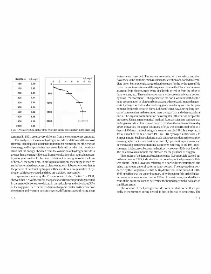
Hydrogen sulfide concentrations of 0, 3 mg/l, under which practicallyno oxygen exists, are regarded as the upper borders of the anaerobiczone. The concentration of H2S increases, reaching to 8-10 mg/l to depthsof 1,500 m, then becomes stable but the maximum concentration in thewater does not exceed 10-12 mg/l. The approximate vertical profile of theH2S concentration (fig. 14) shows that the quantity of H2S gradually de-creases from the bottom to the surface. This testifies to diffusion of hydro-gen sulfide liberating from sediments and mud volcanoes. In the bottomsediments, the contents of H2S vary from 12-16 and reach 160 mg/l. Thedissolved gas-like phase of H2S in the Black Sea reaches 0, 24 g/t todepths of 300 m and 2, 2 g/t – to depths of 2,000 m. Even at these lowconcentration rates, the total quantity that is created annually amounts to107 -108 t. It should be taken into consideration that in seawater H2S is notonly in dissolved gas-like phase but also in the form of sulfides and hydro-sulfides. 9-12 g hydrogen sulfide and its compounds such as thiosulfatesand colloidal molecular sulfur are also contained in each tonne of water.
Under conditions of anaerobic bacterial decomposition of organic matter,except for the hydrogen sulfide, other gases such as methane, nitrogen andcarbon dioxide, are also generated from the bottom sediments. Studies
3 6 3 7
waters were observed. The waters are cooled on the surface and thenflow back to the bottom which results in the creation of a cooled interme-diate layer. Some scientists argue that the reason for the hydrogen sulfiderise is the contamination and the triple increase in the Black Sea biomassas a result from blooms, mass dying of jellyfish, as well as from the influx offecal waters, etc. These phenomena are widespread and cause bottomhypoxia – “suffocation” – of organisms in the north-western shelf due to ahuge accumulation of plankton biomass and other organic matter that gen-erate hydrogen sulfide and absorb oxygen when decaying. Similar phe-nomena frequently occur in Varna Lake and Varna Bay. During long peri-ods of calm weather in the summer, mass dying of fish and other organismsoccur. The organic contamination has a slighter influence on deepwaterprocesses. Using a mathematical method, Russian scientists estimate thathydrogen sulfide will be located only 10 m below the surface of the sea by2020. However, the upper boundary of H2S was determined to be at adepth of 300 m at the beginning of measurements in 1891. In the spring of1984, it reached 90 m, i.e. from 1981 to 1984 hydrogen sulfide rose 2 to3 m per annum. Such calculations, made without considering the complexoceanographic factors and oxidation and H2S production processes, canbe misleading in their estimations. Moreover, referring to the 1981 mea-surement it is incorrect because at that time hydrogen sulfide was found at183 m, and was in amounts that allowed for the presence of oxygen.
The studies of the famous Russian scientist, N. Knipovich, carried outin the summer of 1925, indicated that the boundary of the hydrogen sulfidewas about 100 m. However, referring to a particular measurement andusing it to create general patterns is not correct. The explorations con-ducted by the Bulgarian scientist, A. Rojdestvenski, in the period of 1981-1985 specified that the upper boundary of hydrogen sulfide in the Bulgar-ian water area was located below 150 m. In most cases, standard hori-zons of the ocean are used to determine the boundary, which also leads tosignificant errors.
The location of the hydrogen sulfide border at shallow depths, espe-cially in the summer-spring period, is due to the rise of deepwater. The
termined in 1891, are not very different from the contemporary amounts.The analysis of the rate of hydrogen sulfide oxidation and the ratio of
chemical to biological oxidation is important for estimating the efficiency ofthe energy and bio-producing processes. It should be taken into consider-ation that the energy liberated from the oxidation of hydrogen sulfide isgreater than the energy liberated from the oxidation of an equivalent quan-tity of organic matter. In chemical oxidation, this energy is lost in the formof heat. At the same time, in biological oxidation, the energy is used bysulfur bacteria in the process of chemosynthesis. It becomes clear that inthe process of bacterial hydrogen sulfide creation, new quantities of hy-drogen sulfide are created and they are oxidized incessantly.
Explorations made by the Russian research ship “Vitiaz” in 1988,showed that 70% of the sulfur, manganese and iron compounds generatedin the anaerobic zone are oxidized in the redox layer and only about 30%of the oxygen is used for the oxidation of organic matter. In the centers ofthe eastern and western cyclonic cycles, different stages of rising deep
Fig.14. Average vertical profile of the hydrogen sulfide concentration in the Black Sea

3 8 3 9
up?” published in the Russian newspaper “Literaturnaia Gazetta”, 14th ofJune 1984. The simplest and the most sensational explanation for the odorof rotten eggs was presented to the audience – the hydrogen sulfide wasburning. Such respectful scientific organizations as the Institute of SouthSeas Biology in Sevastopol and the Moscow Institute of Energetic “Krji-janovski” were also involved in the omelet of rotten eggs to bring moreauthenticity to the situation.
What actually happened during the earthquake on the 11th of Septem-ber 1927, known also as the Crimean Earthquake? The earthquake waswith magnitude of about 8 to 9 on Richter scale. Here is what the secretreport of the Russian naval authorities’ state: “A blaze of fire in the seabefore Evpatoria was noticed at 2.48 p.m. Later, at 3.31 p.m. a fire wall –500 m high and 1, 5 miles wide was observed before Sevastopol. A sim-ilar phenomenon was seen from the Lukula observation post. The firsttremor occurred on the 11th of September, 1927, at 10.15 p.m.” Theseevents were registered impartially by the people on duty at the observa-tion posts. Their interpretation 60 years after the earthquake caused a lotof emotions.
At first sight, the explanation that hydrogen sulfide was burning seemslogical. It was claimed that dissolved hydrogen sulfide is found in deepwaters; it comes out to the surface during earthquakes and starts burning.Simple and logical! The major arguments relate to the odor of rotten eggs.It seems that nobody thought of looking up in the chemistry referencebook to read that H2S ignites at 300æ% C and creates explosive mixturesat concentrations in the atmosphere from 4 to 45%. The 0, 1% content ofhydrogen sulfide in the air causes heavy poisonings but fortunately it didn’thappen to the witnesses of the described events. It is known from thechemical kinetics that the oxidation of sulfides to thiosulfates is a reactionof the 1st order and occurs instantaneously. It means that the hydrogensulfide gas would have been oxidized (thus becoming harmless) beforereaching the surface. By the way, the water solutions of sulfides and thio-sulfates also have an odor of rotten eggs.
We need no more arguments to ignore the hypothesis of hydrogen sul-
specific character of the Black Sea hydro-meteorological regime has asignificant impact on the deepwater exchange. During extended periods ofsouthern, south-western and western winds, especially in summer, the warmwater mass moves off-shore from the coast. This water mass is replacedby rising cold deep waters, rich in biogenic elements, which are utilized byplanktonic organisms, causing blooms and the so-called red tide happens.Similar phenomenon of rising deep waters has been already described asupwelling (fig.6). When the wind blows from the sea towards the shore,the surface water mass is pushed to the shore and deep waters rise in thecentral part of the basin. Under such conditions of water exchange, theupper boundary of hydrogen sulfide temporarily rises to its full oxidation.
Upwelling was observed by the authors in August 1986 in the region ofKaliakra Cape during oceanographic explorations carried out by the re-search ship “Researcher”. On 28th of August, the temperature of the waterwas 26æ% C and we were swimming hours and hours regardless of thestrong south-western wind that had forced us to hide in the bay for threedays. When on the 30th of August we decided to refresh again in the sea,we were unpleasantly surprised by the freezing water. We measured thetemperature and hardly believed to what we saw: -7 to -8 æ% C. All ironobjects on the deck had become black. Oxygen was absent from thesurface to the bottom.
The hydrogen sulfide zone in the Black Sea is in a relatively stablebalance. It is determined by the existing oceanographic factors, the pro-cesses of chemical and bacterial oxidation. Its creation and developmentis a natural process.
Will the Black Sea blow up? The topic attracted world media attentionin the early 80’s following the disclosure of Russion Navy’s reports on thestrange phenomena in the Sea during the September 1927 earthquake inthe Crimea.
The assumption of the hydrogen sulfide nature of the blown gases in thesea near Sevastopol in 1927 is a product of the far-fetched idea of ahydrogen sulfide catastrophe. The hydrogen sulfide “hysteria” started withan article by the journalist, A. Spiridonov, “When the Black Sea will blow
4 0 4 1
This is a brief explanation of the so called “hydrogen sulfide bomb”.Once again, we would like to remind the admirers of sensations to try tothink of more serious “scientific” arguments.
The naive, primitive description of the “hydrogen sulfide bomb” andthe hydrogen sulfide problem, as well as ill-founded writings on ecological
technologies referring to prestigious scientists and institutions cannot beregarded as reliable. Unfortunately, the “hydrogen sulfide bomb” has beenpresented as an ecological argument until quite recently. That’s why thediscussion on “Blue Bourn” turned into ecological odyssey.
“Blue Bourn” provided for the construction of pipelines across the BlackSea floor between the Russian harbor Djubga and the Turkish harbor Sam-sun. Transporting gas and oil through pipelines is significantly safer thantransporting by tankers. It is widely used around the world. The bottom ofthe world ocean is crossed by hundreds of miles of pipelines with mini-mum failures.
Ill informed ecologists wordily explained to the public that the pipelinewould break and that leaking gas would interact with hydrogen sulfide anda gigantic explosion would happen. These ridiculous arguments were en-tirely disregarded by the specialists. Now, when the two pipelines on the
Fig.15b. Mud volcano on the Black Sea seafloor (sonar picture)
fide ignition. In this case, what did the witnesses see? Here is the opinionof the famous Russian geologist S. I. Popov, also a witness of the event: “Itwas an explosion of methane, thrown from fractures to the bottom whenunderwater mud volcanoes at the time of the earthquake.” Unfortunately,Popov’s opinion had been hidden from the public for many years. There isone more fact that is also very typical of the character of the event. In theSevastopol region, in 1926 and 1927, the Expedition for UnderwaterWorks with Special Allocation (EPRON) carried out rescue operationspulling out Russian naval ships sunk during the Civil War. The Japanesedivers, who participated in this expedition, suddenly interrupted their work.The chief of the rescue operations, S. N. Unkovski, said that the activitieswere stopped because the visibility rapidly decreased as a result of theintensive liberation of gas from the seafloor. Later, the detailed study ofgas eruptions on the Black Sea floor allowed the scientists to develop theconcept of geodynamic sites for notifying earthquakes.
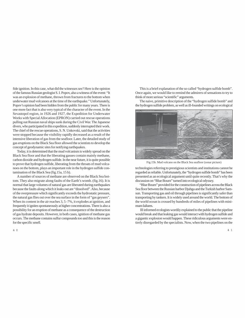
Today, it is determined that the mud volcanism is widely spread on theBlack Sea floor and that the liberating gasses contain mainly methane,carbon dioxide and hydrogen sulfide. In the near future, it is quite possibleto prove that hydrogen sulfide, liberating from the throats of mud volca-noes on the bottom, plays an important role in the hydrogen sulfide con-tamination of the Black Sea (fig.15a, 15 b).
A number of sources of methane are observed on the Black Sea bot-tom. They also migrate along faults of the Earth’s womb. (fig.16). It isnormal that large volumes of natural gas are liberated during earthquakesbecause the faults along which it leaks out are “dissolved”. Also, becauseof the overpressure which significantly exceeds the hydrostatic pressure,the natural gas flies out over the sea surface in the form of “gas geysers”.When its content in the air reaches 3, 5 -7%, it explodes at ignition, andfrequently it ignites spontaneously at higher concentrations. There is also apossibility for an eruption of methane as a consequence of the destructionof gas hydrate deposits. However, in both cases, ignition of methane gasoccurs. The methane contains sulfur compounds too and this is the reasonfor the specific smell.

4 2 4 3
sea will be damaged which mayhave a number of unpredictableconsequences. Undoubtedly, all“laboratory” projects carriedout without a profound knowl-edge of the contradictory spe-cifics of the Black Sea aredoomed to failure. What are theways to utilize hydrogen sulfideas an energy resource? Themyth about producing hydro-gen sulfide from seawater forenergy purposes was widelypromoted by a research teamled by the Russian academician,R.B. Ahmedov. The initial en-thusiasm was replaced by apessimistic realism after the firstcalculations of hydrogen sulfideconcentrations and the amountsthat can be obtained per unitvolume of seawater. The situa-tion is reminiscent of the opti-mism of German scientists dur-ing the 1930’s, when they wereinspired by the idea of extract-ing gold from the ocean water.The experimental technologicalinstallation showed the com-plete failure of this concept.
The quantity of hydrogensulfide gas, extracted from 1m3
sea water amounts to aboutFig.16. Gas fountains on the Black Sea
seafloor (the paleo-valley of theProvadijska River)
bottom are a reality, the commentary is unnecessary.The Black Sea is a natural laboratory which hides enormous reserves
of energy resources. The numbers cited are really impressive. However,the fact that hydrogen sulfide and other gases are found in a dispersedstate should also be taken into consideration. The content of hydrogensulfide varies from 1, 9 to 12 mg per liter of seawater to depths of 300 to2,000 m respectively. Bulgarian researchers are familiar with the idea ofutilizing hydrogen sulfide as an energy resource. It is very attractive mainlyfrom an ecological point of view as it is related to zero-waste technology.However, most solutions are based on the fact that the hydrogen sulfide isin the form of dissolved gas. Only 10-20% of its total amount is free H2S,while the remainder consists of compounds that are dissolved in the seawater and do not burn. The same applies to ammonia (free gas) and am-monia compounds. According to our calculations, (reported to the Na-tional Conference on Utilizing Sea Resources, 1984, Varna) 20,000,000m3 seawater are necessary for the production of 1,000 m3 hydrogen sul-fide. Technologies, published up to now, state that: “several hundred pumps,which are used in the cooling system of a Thermal Power Station, aresufficient to decrease the upper boundary of hydrogen sulfide.” It is truethat such a project existed. A society named “Ecoenergetics” was createdin Sevastopol in 1989 to investigate utilizing the hydrogen sulfide resourc-es of the Black Sea. It was thought that 7-8 mg H2S per liter were con-tained at depths of 150-200 m. It was planned that 2,500 km3 waterswould be pumped from the sea for the extraction of hydrogen sulfide. Forthe realization of this project (to pump water and produce sulfur, hydrogensulfide, heavy water and some metals and then bring the water back intothe sea), plans were produced to build 20 thermal stations with a power of25 million kilo Vats along the Caucasus coast. We can only imagine theconsequences of such a large-scale project on the Black Sea environ-ment. Deep waters, from which hydrogen sulfide would be extracted, con-tain biogenic components in much higher concentrations. Under these newconditions, these concentrations will cause constant blooms, i.e. the tech-nology is not ecological. Besides, the current hydrological structure of the

4 4 4 5
Chapter 4The Black Sea Coast and Shelf – a Center of
Flourishing Pre-Flood CivilizationsThe geological proof of the Flood convincingly testifies to an event that
was extreme in magnitude with catastrophic consequences. A significantpart of the land was submerged by surging waves. The old shorelines thatwere the center of a flourishing Pre-Flood civilization were drowned bythe sea. Our archeological museums are very proud of the remains of thiscivilization that have been found along the whole Black Sea coast. Indis-putably, the Varna necropolis is the most important and sensational dis-covery of Bulgarian archaeologists.
The necropolis was discovered in 1972 during building operations inthe Varna industrial zone. The interesting story of this discovery has beentold by the late Ivan Ivanov who led the excavations. As well as carryingout the excavations very professionally, he made a lot of effort to have theunique Eneolithic treasure placed in the Varna Archaeological Museum.We would like to emphasize the exceptional contribution of Ivan Ivanov tothe preservation of the cultural and historical heritage of North-EasternBulgaria and particularly of Varna. Returning to our story, the excavatoroperator, Rajcho Marinov, noticed an object hanging on the cogs of thelitter-bin and he went to clean it. Then he saw other unearthed items. Heunderstood he had come upon archaeological findings. He delivered theitems to the curator of the Dulgopol Museum, Dimitar Zlatarov, who, inturn, notified the Varna archaeologists. They were on the site on the 3rd ofNovember 1972. The initial euphoria provoked by the discovery of theoldest processed gold coming from a civilization more ancient than theMesopotamia and Egypt civilizations, was followed by days and days ofhard work – excavation operations, classifications, analyses, etc. The Varnanecropolis gave new valuable artifacts for the most ancient civilization. Anarea of 7,500 m2 was explored and 294 graves with rich and variousinventories were found. The great number of golden items, over 3,000with a total weight of 6 kg, puzzled the scientists. More gold than the total
0,24 g/tone at a depth of 300 m and 2,2 g/t at a depth of 2,000 m. Actu-ally, the total quantity of hydrogen sulfide in the Black Sea basin amountsto tens of billions t. No less impressive is the amount of annual production.Of course, the studies and researches on hydrogen sulfide utilization shouldcontinue but too much optimism can lead to disappointment. The technol-ogy for extracting sapropels from the sea bottom and en-route productionof hydrogen sulfide and methane seems to be more acceptable. Thesapropels from the Black Sea bottom that we have already determined asa product of the flood are important potential raw material for the future.They can be used as natural ecological fertilizer, for re-cultivation of dirtyand hydro-isolated materials, filters for cleaning polluted waters, pharma-ceuticals, and mud cures. The largest part of hydrogen sulfide comes throughthe Earth’s womb diffuses through sapropels where the concentrations aresignificant and then spreads in the seawater. Many drillings along the BlackSea coast, from which pressure waters rich in hydrogen sulfide come out,support this thesis.

4 6 4 7
marine civilization that is genetically related to the sea. On the one hand,centers of ore-production and metallurgy of gold and copper were locat-ed along the coast (around the present mines of Meden Rid, Rossen,Surneshko Kladenche and Varna). On the other hand crafts flourishedaround large administrative centers. The constant trade relations within theBlack Sea region and with the Mediterranean region were of great impor-tance for the development of the society together with the processing ofgold and copper. In the Varna necropolis were found more than 12,000shells of Dentalium type and hundreds of Spondylus. Most probably it isthe oldest pre-coin forms of Eneolithic society. The old shoreline, nowunderwater, and the shores of the Varna lakes were probably centers ofproduction of copper and stone tools, as well as golden jewelry.
The main trade routes to the northern Black Sea and other Black Seaharbors passed through the region. This is evidenced by the 443 coppertools found in Karbuna, on the Middle Dniester River bank and the findingof metal on the Volga River bank near Saratov. There are similar findsfrom Velke Rashkovitze in Slovakia. Analogous copper tools and goldenanthropomorphous amulets are found in Varna and other places in Bulgar-ia. These numerous facts and findings give a sound basis for ascertainingthat a significant part of the Balkan Peninsula and the Black Sea regionwas encompassed by identical material and intellectual cultures (fig. 17).
Recently, a historian from Varna, well known as an intense opponent ofthe Flood occurring in the Black Sea, made a sensational announcement.In his book “The Jews and Judaism – the beginning of the human civiliza-tion 7,000 years ago” he struck public opinion with the claim that the Jewscreated the first human civilization. Also he talks about a golden treasuredated to 4, 3000 BC. It was exported from Bulgaria 30 years ago andlater on ransomed by the well-known businessman Michael Chorni. To-day, as the author claims, the treasure is in a bank safe in Sofia. Probably,it is a finding of the type from the Varna Eneolithic necropolis. Of course,the pro-Jewish interpretation is at his expense. The point is that more andmore new facts about the Varna pre-Flood civilization are being collected.
Unfortunately, the exploration of the spiritual culture during the Eneolithic
amount of gold found around the world from this period was discovered inonly one grave. Copper, flint, stone tools, and jewelry of metal, bones,minerals and shells of the Mediterranean mollusks Dentalium and Spondi-lus – about 22, 000 items - were also found.
Thirty years ago, the young scientists could hardly imagine the impor-tance of the Varna necropolis. It is irrefutable proof that an ancient civiliza-tion, older than the Egyptian and Mesopotamian civilizations, existed onthe Bulgarian lands. The Varna necropolis is not the only finding of thekind. One of the most devoted advocates of the hypothesis that Bulgarianlands, particularly the Black Sea coast, were the center of the earliestcivilization in human history is Prof. Dr. Henrieta Todorova. She studiesthe ancient history of North Eastern Bulgaria and led the archaeologicalexcavations in the regions of Shabla, Durankulak, and Devnia. The resultsof her research are presented in a number of publications including “TheStone-Copper Age in Bulgaria” “Durankulak” and “New Stone Age inBulgaria”.
Here is what Prof. Todorova said in an interview under the headline“The Black Sea is the earliest center of civilization in human history”:
“Many people are reluctant to believe that but it is true. It is obviousfrom the social structure in 5,000 BC which is adequate to the scientificrequirements for the creation of a civilization: social differentiation of thepopulation in rich and poor, monumental architecture, royal domination,differentiated production and trade relations. Historians discovered thatthese elements had first appeared on the Black Sea coast during the lastquarter of the 5th millennium, i.e. earlier than in Mesopotamia, earlier thananything that has been known to people as the first civilization. It hap-pened that after 1975-1976, in the opposite of the accepted concepts forearly and most early, we, the Bulgarians represented something even ear-lier. Of course, there were reproaches that we were just telling stories.However, the excavations carried out in several very important sites of-fered an opportunity to trace the creation and development of this ancientcivilization”.
This culture, called “Varna culture”, testifies to the existence of a typical

4 8 4 9
period, as well as during the other prehistoric epochs, is difficult due tolack of writing, which would have given most of the information necessaryto elucidate the basic cult-religious and everyday life characteristics of thesociety. Practically, all researchers are unanimous that between the Varnaand Durankulak necropolis exist common features that give informationabout the common intellectual culture in this period and of course, aboutthe level of the material culture, social and economic development.
For more than 30 years the questions concerning the age of the Du-rankulak (fig. 18a, 18b, 18c, 18d, 18e) and the Varna (fig. 19) necropolishave been disturbing our researchers. The data derived by the relativemethod indicates as age of 4,600-4,200 BC, while the conventional dat-ing refers the finds to 3,500-3,200 BC. The Durankulak necropolis isdated to 5,270 BC by absolute dating. We think that the dating of the Varnanecropolis (fig. 19) is significantly underestimated. According to our opin-ion, the age of the findings in Varna should be dated to 5,000-6,000 BC.
The age of the drowned settlements so far discovered in Varna Lakecoincides with the age of the Varna necropolis. These settlements indicatea considerable concentration of population along the shores of that time –probably they were crowded around large administrative, cultural and tradecenters that are supposed to be located along the old shores. The largenumbers of finds of gold, copper, flint, ceramics, rock tools and others,the method of processing, shape and other features suggest the existenceof a well-organized community, much more advanced than the primitivesociety, which was on the brink of creating a state formation known as aslavery society.
In the spirit of the theory about the World Flood in the Black Sea, thepresence of the Varna and Durankulak necropolis is an important prereq-uisite for creating an overall concept of the existence of a highly developedcivilization until the Flood.
Many years of research on the old drowned Black Sea coast and thedeepwater sapropel sediments, which resulted from a geological catastro-phe, allowed us to obtain reliable information about the absolute dating ofthe event. The contours of the old shorelines and a comparison with theFig.17. Schema of the spread of Hamandjia culture in Dobroudja
(6,000-5,000 BC, author T. Dimov)

5 0 5 1
entirely drowned in a month and the survivors searched for safety inland.The Flood continued and the Black Sea level and Mediterranean Sea
level became equal. Then the Black Sea slowly modified to the land untilacquiring its present outline.
Unfortunately, archaeological underwater explorations have been car-ried out mainly in the coastal part of the shelf where usually, Roman andByzantine antiquities, are discovered.
The contemporary shelf (as already mentioned, see Chapter 1) is di-vided in three areas, (fig. 3) which are differentiated according to the char-acter of relief and the rates of contemporary sedimentation: coastal, cen-tral and peripheral. The coastal area is located adjacent to the shore todepths of 20-50 m. Underwater archaeological researches on civilizationsof Roman and Byzantine times are carried out in this area. It is possiblethat new methods will allow specialists to decipher more ancient civiliza-tions in the future. The central area of the shelf is distinguished by extreme-ly high rates of sedimentation- the thickness of the sediments reaches 30-40 m. It makes the underwater work of archaeologists very difficult. Theouter or peripheral part of the shelf, where the ancient Black Sea shore-lines are fixed, is very favorable for underwater archaeological activities.Here, the thickness of the sediments is 10-15 cm but in some locationsthey are entirely missing and sand stones are exposed. The seismic-acousticrecords of the peripheral shelf area fix 2-3 bars which are actually drowneddune formations or coastal bars (fig. 11). After diagnosing the old shore-lines at the end of the 1980’s, it was assumed that our predecessors usedto live right here. At that time we were also looking for remains of oldsettlements in the region of the old Black Sea shoreline. Recently, Dr.Robert Ballard has announced a discovery of a possible Neolithic settle-ment at a depth of 90 m in the region of the Turkish harbor Sinop(fig. 20a, 20b)
Nearly eight millenniums have passed since the Flood. In other words200 generations completed their life course at an average life expectancyof 40-50 years. Before the Flood, Neolithic people inhabited not onlytoday’s coast but also that part of the bottom (called the shelf) which was
contemporary ones (fig.1) show that they are located 50-70 km east ofthe Varna and Durankulak necropolis.
It is obvious that the remains of most of the territory of the civilizationexisting at that time are found in the shelf buried under a thick layer ofooze. The population was concentrated mainly along the coasts of seasand oceans. This location provided the means of living, transport, traderelations and economic prosperity.
The main question is about the age of the event that had catastrophicconsequences on the coast and the destiny of the existing civilization. Themore than 100 absolute datings, made on sediments by the radiocarbonmethod (14C), indicate that the Flood occurred about 7,600 years ago.Most reliable are the analyses of the lower part of the sapropel sediments.The organogenetic plankton sediments – sapropels lay over the carbonatesediments that were created under freshwater sea-lake conditions. Datingof the layer of contact between the two types of sediments that actuallyfixes the beginning of the Flood, gives an age of 8,000-7,600. To a largeextent, it coincides with the dating of the prehistoric civilization that inhab-ited the coast – 5,270 BC. Close to these values is the 14C dating ofmollusks Mytilus galloprovincialis and Mondacna caspia, which penetrat-ed into the Black Sea after the flood and are aged 8,000-6,800 years.The 14C dating of the shells Dreissena rostriformis distincta, located on theshelf that was the arena of dramatic events resulting from the flood, variesfrom 11,000 to 9,000 years. Probably, the latest data is overvalued due toerosion of sediments on the shelf. This gives a sound reason to regard thedating on the lower part of the sapropels (8,000 –to 7,600 years) as themore probable date of the beginning of the flood.
We have already talked about the scale of the event called the Floodand its consequences on the coast and civilization of that time. The idyllicpicture of waves lapping gently against the shore and the undisturbed ev-eryday life was destroyed. God vented his anger on the coast. Oceanwaters intruded through the Bosporus sill. The Black Sea level rose 10-15cm and the shore advanced 1 km towards the land in 24 hours. The in-truding waves swept away everything on their way. The old shores were

5 2 5 3
Chapter 5Names of the Black Sea
Little or even nothing is known about the names of the Black Sea priorto the Flood. Eight thousand years ago it was a freshwater lake and itsshores were far from the present shores. Today the old pre-Flood shoresof the sea are located underwater at depths from 90 to 120 m at thepresent edge of the shelf. Beaches, dunes, bars, analogous to the presentones can be seen here. Most of them are covered by thin 10-15 cm oozebut at some locations with strong currents, beach sands lay bare on thebottom. The territory of today’s Azov Sea and the contemporary shelfwere fertile plains through which the beds of the rivers passed flowing intothe Black Sea of that time. We can only assume that it was called not theBlack but the White Sea or the Sea of Prosperity. This is proved by theclimate and character of the lake-sea. The favorable natural conditionsand the high biological productivity were the natural factors influencing theconcentration of significant human population along the coast and the ori-gins of an advanced civilization.
The nearby ore deposits were a favorable precondition for the devel-opment of ore- production, metallurgy and handicrafts. The first labor tools,everyday items and copper and golden jewelry were made.
The first piece of information about the name of the Black Sea after theFlood is found in the Sumerian Gilgamesh Epic. The story of Gilgamesh,retold in the Pierre Grimal’s book “Stories from Babylon and Persia”,gives indirect proof of the place of the Flood. This story unambiguouslyconfirms that the Flood occurred in the Black Sea:
“Gilgamesh had heard that an old man, living at the mouth of all rivers,at the ends of the world, was the only mortal on whom the gods hadgranted an eternal life. Gilgamesh decided to find the man, called Utnap-ishtim in order to learn the secret of eternal life. Without taking any advicehe undertook this most perilous journey of all.”
After a long and tiresome journey, accompanied by a number of dan-gers, Gilgamesh came to an inn by the ocean shore; the inn was kept by
land at that time. It was lowland, cut by a number of rivers flowing into theBlack Sea Lake of the time. The favorable climatic conditions were notthe only factor influencing the cultural boom. The region was rich in miner-al resources, especially in copper ores which was a raw material used formaking copper tools and golden jewelry. The analysis of the metals indi-cates that they have a local origin.
Located away from the big climatic changes, the Black Sea Lake wasan oasis of prosperity. Favorable climate, fertile valleys, rivers and lakesteeming with fish were an important prerequisite for the development ofhuman civilization, i.e., man was not only searching for food but also do-mesticating animals and cultivating plants. Looking at the remains of Neolithicsettlements and tombs along the present coast, we couldn’t help admiringthe skills and talents of ancient builders.
The map of the most important Neolithic and Eneolithic settlements(fig. 17) shows a significant concentration of population across the Bul-garian lands.
The collapse of the doctrines of the place of the Biblical Flood seemsto be predetermined by the Bible itself. It is impossible that a misconcep-tion, being perpetuated by the Judaic clerics for thousands of years, willdominate forever. The occurrence of the Flood in the Black Sea is a fact.

5 4 5 5
shoot with bow and hit the game with arrows. They will be your immortal-ity, Gilgamesh. And you have to learn how to leave that happiness whenthe time comes.”
However Siduri couldn’t dissuade Gilgamesh. He kept on asking aboutthe location of Utnapishtim. At the end she agreed to show him the way.
“The old man Utnapishtim,” said Siduri, “ lives on an unreachable is-land. The island is surrounded by the ocean and you cannot cross it. ButI’ll tell you how to do it. Right now the Utnapishtim’s ferryman is here andif he wishes, he will take you to the island.”
Gilgamesh went to look for the ferryman (who was called Urshanabi)and found him in the woods, where he was collecting herbs for Utnapish-tim. When Gilgamesh told of his request, the ferryman willingly agreed totake Gilgamesh with him but he warned him, “The waters we are to crossare the Waters of Death. Should any mortal touch the waters, that man willinstantly die.”
They traveled for a month and a half until reaching the Waters of Death.A question comes to one’s mind - where was Siduri’s inn? With more
imagination, we could assume that “the hotel” of Siduri was located some-where along the coasts of the Dardanelles or the Bosporus. The route ofGilgamesh according to the legend is shown on the map (fig. 21). “TheSea of Death” that they had to cross, looked a lot like the Black Sea afterthe Flood. The hydrogen sulfide had poisoned even the surface waters.Many years passed before the sea acquired its contemporary hydrologi-cal structure.
But let’s go on with the Gilgamesh’s mission when he discovered theSumerian Noah-Utnapishtim on an island, which we suppose, was locat-ed in the Black Sea.
Filled with curiosity, he made his way to the wharf. When he saw Ut-napishtim on the shore, Gilgamesh understood that his trip was over. Hegreeted the old man and told him about the purpose of his visit.
“Young man” said the old man, “what you are looking for is not here.Death is the condition under which the gods agreed to give life. Whenpeople sign an agreement – a period of execution and a price should be
Siduri. Here is their conversation:“Who are you?” asked Siduri, “making such a noise before my door?
What is your name, where do you come from and what do you want?”“Hostess,” said Gilgamesh, “I am a powerful king. I run the city of
Uruk and my name is Gilgamesh. I come here as a friend not as an enemyand I beg you for help.”
Siduri looked carefully at the stranger and saw his worn-out face. Sheunderstood that he had come from far away and that he was telling thetruth. So she consented to open the door and welcomed him in a largesaloon. How marvelous Siduri’s inn was! It was an enormous shadowyhall with shining tiles and gently walking servant maids. They offered himcold water and he drank a long time, then he ate fruits and meat andrestored his strength. She approached him and started asking questionsagain.
“I understand that you come from far away. I don’t know the city ofUruk which is on the other side of the Mount Mashu, in the country wherethe Sun goes. But I know your name. Aren’t you the one who killed Humba-ba the Terrible and the Bull of Heaven?”
When he heard about his feats, Gilgamesh wept because he recalledhis friend Enkidu with whom he had realized all those deeds. The remem-brances of Enkidu made him feel his sorrow again.
“Yes,” replied Gilgamesh,“ I did these things and I did them with thebest friend in the world, Enkidu but he is dead now. I watched over hisbody in my palace and I saw how life was leaving him. I saw the featuresof his face distorting with pain and since then I have been roaming aroundthe world to find the secret of eternal life.”
“Gilgamesh,” said Siduri, “ no mortal human being can learn that se-cret. When gods created people and gave them the Earth, they grantedDeath on them too. This is their destiny, this is the price they pay for thehappiness to be alive. So live, enjoy your life, make every day, every houra feast. Look at the fruits of this vine, pick up the grapes, squeeze out thejuice and taste it. Wear embroidered clothes that catch the eye, bathe infresh water. Have children, rejoice at them running, and teach them to
5 6 5 7
blessed us to be immortal.”“So now, Gilgamesh you know why I am the only immortal of all hu-
mans.”Gilgamesh understood that the old man had no secret because the gods
had blessed him with immortality without his doing anything to deserve it.Certainly, the Gilgamesh Epic provokes our imagination. The Sumerian
Noah-Utnapishtim must have settled on a small island in the Black Seaafter surviving the Flood. Therefore, if the official version of the site of theflood is rejected, the place where Noah’s boat arrived should not be MountArarat but an island in the Black Sea. If we assume that the Black Sealevel was 40 m below the contemporary sea level, it is possible that Noah’sArk has been covered by a thick layer of sediments. Our assumptions areclose to science fiction, so let us return to more realistic matters.
It is obvious that the memories and legends about the “Sea of Death”have left a fatal, dismal mark on the name of the Black Sea. This mark wasstrong enough to remain for the next millenniums.
After the mythical trip of Gilgamesh, the Phoenicians were the first topenetrate the Black Sea. They are thought to originate from Abraham’sfamily. It happened about 2,000 BC. The oldest anchor which testifies tothe ancient shipping in the Black Sea is 3,500 years old. It was discoveredby Bulgarian archaeologists during underwater explorations near KalikaraCape in 1975. The anchor belonged to a Cretan ship, sunk near the Bul-garian coast in the 16th -15th century BC, i.e. several centuries before theArgonauts’ trip.
The most ancient, native inhabitants of the Black Sea coasts are theCimmerians31. There is no data if they had survived the Flood and stayedhere but probably they gave the name –Black Sea. Maybe, the Cimmeri-ans were replaced by the Thracians. The Scythians32, who drove awaythe Cimmerians at the end of 8th century BC, called the sea Axsaena – anold Iranian word, which means “dark colored”. The Greek name of theBlack Sea – Pontus Axeinus, means “inhospitable”. According to the Er-atosthenes’ writings (3rd century BC), the sea was inaccessible for theancient Greeks because of the mighty storms and the barbarous Scythian
determined. Birds come into the world, live and die; the hatred betweenpeople rises and then abates; the leaves of the trees bloom from buds andwither in the autumn. The life that you received and you want to keepdoesn’t belong to you. You must devote it to the others who in turn willcome in the world to know the light of the sun and the happiness to breathethe wind in the forest.”
“This is true,” said Gilgamesh, “but in the end, you have escaped fromDeath! And I don’t think you are different from me. You have the courageto throw into a fight, eyes to see with, and arms to fight with. Tell me thesecret that made you immortal!”
“Listen, Gilgamesh, how I have reached eternity. Many years ago, whenI was still young, the counsel of the gods held a secret meeting; they allresolved to destroy the world in a great flood. All the gods were underoath not to reveal this secret to any living thing, but Ea (one of the godsthat created humanity) came to my house and told the secret to the wallsof the house, thus not violating his oath to the rest of the gods. He advisedthe walls of my house to build a great boat, its length as great as its breadth,to cover the boat, and to bring all living creatures into the boat. I gotstraight to work and finished the great boat by the new year. Then I loadedthe boat with gold, silver, and all the living things of the earth, and I launchedthe boat. The black clouds arrived, with thunder god Adad rumbling with-in them; the earth split like an earthenware pot, and all the light turned todarkness. The Flood lasted for seven days and seven nights, and finallylight returned to the earth. I opened a window and the entire earth hadbeen turned into a flat ocean; all humans had been turned to stone. I fell onmy knees and wept. My boat lodged firmly on the mountain peak justbelow the surface of the ocean and remained there for seven days. On theseventh day I sent out all the living things in every direction and sacrificeda sheep on that very spot.”
“The gods smelt the odor of the sacrifice and began to gather aroundme. Enlil, who had originally proposed to destroy all humans, then arrivedfurious that one of the humans survived. He accused Ea of treachery, butEa convinced Enlil to be merciful. Enlil then seized me and my wife and

5 8 5 9
seaport Suroj, in the Middle Ages. The Turkish called it Bahri-Saiat, andnow they call it Kara Denis. In his book “History of World Trade”, Noelstates that according to Marco Polo’s map, the Black Sea was called MerGrecnor, i.e. Greek Sea, in the middle of the 13th century.
More than 1,500 maps of the world ocean are known. The Black Seais marked on about 300 of them. The maps and portolans were made byGenoese and Venetian merchants and seamen (fig.23). Many geographi-cal objects and the outlines of the shorelines were incorrect but neverthe-less they were of great importance at the time.
The present name –Black Sea – is famous among almost all the peo-ples during the Middle Ages and it has not been changed since then. Thereare a lot of theories on its origin but probably it came from a tragic eventconcerning the very beginning of human history which was preserved andretold in the ancient myths.
tribes that offered the ancient sailors to gods as a sacrifice and were alsocannibals.
After the establishment of the first Greek colonies along the coast, ac-cording to Strabo33 (63 BC- 24 AD), the Black Sea was called PontusEuxinus, i.e. “hospitable sea”. Apparently, the Greek sailors became ac-quainted with the sea and probably coped with the attacks of the Thracianpirates. In some ancient annals the Black Sea is named also “the ScythianSea”. Herodotus called the Azov Sea Meotida (the mother of the BlackSea), which probably originates from the ancient Scythian name Temerni-da (translation from Scythian – the mother of the sea).
One of the most prominent ancient Greek myths is devoted to the questof the Golden Fleece by the Argo ship. After a voyage of incredible perils,the Argonauts led by Jason, reached Colchis, the country in which theGolden Fleece was held by King Aeëtes. With the help of Medea, thedaughter of the king, Jason stole the Golden Fleece. Carrying the fleeceand accompanied by Medea, Jason and his crew managed to escape fromAeëtes.
The Argo trip was carried out about the 13-14th century BC and it wasdescribed by Homer in the 8th century BC. The same story is told byApollonius of Rhodes in his work “Argonautica” but much later (295 –215 BC). The heroic feats of the Argonauts are technically the first literaryreference describing the pirates in the Black Sea (fig. 22).
In 1985, the Englishman, Tim Severin, built a copy of the Argo ship andorganized the Jason Voyage. His crew rowed and sailed from Greece,through the Dardanelles and across the Black Sea. The Bulgarian sailor,Teodor Troev, who participated in this expedition, published a very inter-esting book “On the Tracks of the Argonauts“. This experiment provedthat the Argonauts’ trip was a real possibility.
The names of the Black Sea - Pontic Sea, Pontus Euxinus – which thesea was given during the Greek colonization are most popular. The Arabi-an writers named the Black Sea “Neytas” (Severe Sea). It was also knownas the Byzantine Sea and the Slav Sea.
The Russian annals say it was called Surojko Sea – named from the

6 0 6 1
surf niches, cut in the body of the old underwater volcanoes and the boul-der-gravel beaches, are silent witnesses to the waves surging around theislands that were swallowed by the severe storm.
Almost all the shorelines formed during the Wurm glaciation are locat-ed at depths 130-140 m below the present sea level and are 17-18,000years old. We are convinced that the level of the Mediterranean Sea andthe Atlantic Ocean during the last 8-10,000 years rapidly outstripped thelevel of the Black Sea due to the different climatic conditions (fig.10).
Unfortunately, failures chased us during the trip and Atlantis becameeven more mysterious and unreachable.
At that time I remembered about my Black Sea old shorelines, unseenby a human yet. I told my Russian friend, Prof. Viacheslav Iastrebov, (whowas then a director of the Moscow Institute of Oceanology) about myidea to explore with the submersible Argus the old Black Sea shorelineswhere I believed people had lived before the Flood. Iastrebov, a famousundersea explorer, a constructor of a number of manned and unmannedunderwater apparatus, today an academician in the Russian Academy ofScience, liked the idea very much: “OK, Petia, you convinced me. Theship Rift and the Argus will be at your disposal in Varna.” These were hiswords and he kept his promise.
In July1985, the research ship Rift with the snow-white submersibleArgus on board gently swayed over the old shorelines, hidden under 100m of water, 30 miles east of Varna.
The old shorelines of the Black Sea, overflowed and dried throughoutthe millenniums, are silent observers of the inexorable course of geologicalhistory and human civilization.
The last glaciation on earth – the Wurm – lasted for several tens ofthousand years. It started about 80-70,000 years ago and ended about11-10, 000 years ago. The rise in the World ocean level started simulta-neously with the melting of glaciers. At that time the Black Sea was almosta freshwater lake not connected with the ocean. This stage of the devel-opment of the basin is known as Neoeuxine transgression (or the pre-deluge Black Sea). The outlines of the contemporary and Neoeuxine ba-
Chaptar 6The Black Sea – a Key to the Mystery of the World Flood
In their book “Noah’s Flood” the American geologists, Bill Ryan andWalter Pitman, discuss a well known and yet debatable topic – the WorldFlood. I am very grateful to them for noting my contribution to the study ofthe Flood in the Black Sea. Indeed, when I received the thesis of theirhypothesis in 1993, I instinctively accepted the presented scientific ver-sion because actually it was mine too. I supported them by sending all myarticles referring to the matter and I assured them that they were on theright track. Our correspondence turned out to be a very useful scientificcommunication and in the course of time new ideas came into being.
I remember when I presented a dissertation on the old Black Sea shore-lines at the Moscow Institute of Oceanology, in 1979, the chairman of thecommission, the late Pantelejmon L. Bezrukov, interrupted me: “You don’tmake an analogy between the Black Sea flood and the Bible Flood, doyou?” And I replied: “Everything is possible”. He intentionally directed meto the subject about the connection between the geocatastrophic events inthe Black Sea and the flood described in the Bible and the Sumerian epic.I enthusiastically embraced the idea that anyway attracted me –the oldBlack Sea shorelines located at depths of 90-120 m might be the key tothe mystery of the Flood. Later on, when my professional interest focusedon the origin of the deepwater sediments in the Black Sea, my convictionthat a catastrophic event caused their formation became firmer. The drown-ing of the old shores and the creation of the geocatastrophic deepwatersapropel sediments were found to result from one and the same event –the Flood.
In 1984, I was invited to participate in an international expedition withthe Soviet research ship “Vitiaz”. The task of the expedition was veryenticing – of the search for Atlantis. The dives with the manned submers-ible Argus in the peaks and slopes of the underwater mountains Vercelli(Tyrrhenian Sea), Ampere and Josephine (the Atlantic Ocean) gave methe opportunity to get familiar with the old shorelines of the ocean. The

6 2 6 3
Fig. 25. Profile of the shelf and the course of thecatastrophic geological events during the last
8,000 years
covered the object. Our pa-tience lasted for half an houruntil the cloud of oozecleared a little. Astonishing-ly, we saw an object withvague outlines stuck into thesand instead of the expect-ed round stone. Thestretched mechanical handof the submersible clutchedan item looking like a platewith a slightly jagged edgefrom the one side. After hardefforts, the object was ex-tracted from the sand andput in a sample container.Then we were in a hurry tosurface with the preciousobject. “
Right after we got out ofthe submersible and steppedon deck, the “Noah’s plate”as we named it (fig. 27a),was in the hands of our im-patient colleagues who ex-amined it enthusiastically.The object posed a numberof questions, some of whichare still waiting for answers.The most acceptable versionis that the item was discov-ered in situ where it had
sin are shown on fig. 24. It is well seen that the present shelf was land inthe past. The level of the Neoeuxine basin was about 90-120 m lowerthan the present level (fig. 25), which means that the Neoeuxine shore waslocated on the present edge of the shelf. The large shelf plain was cut byrivers that ran into the basin.
The absolute dating of the Neoeuxine shores (located 90-120 m be-low the present level) indicates an age of 9-10,000 years, whereas thesynchronous in time of formation deepwater sapropel sediments are 7-8,000 years old. The reason is that the deepwater sapropel ooze is de-posited in a calm environment, while the shelf ooze was subject to partialerosion as a result of the Flood.
It seems that the catastrophe occurred in the interval between 7, 5 –8,000 years from today, and the result was significant erosion of the sed-iments on the shelf.
Here is a short paragraph from the log-book I kept during the divesconducted by the manned submersible craft Argus in July 1985: “Tired ofpeering through the illuminator and mostly of the monotonous plain surfaceof the bottom, annoyed by the invisible cold, which penetrated through thesteel walls, depressed by the narrowness, we noticed a protuberance 10m away from us. We were on the shelf, in the region of the old beaches,located at depths of 90-120 m (as shown on fig.25). This is the zone oflife; the visibility is very good – 15-20 m. The curious Black Sea sharks,attracted by light, often halt in front of the illuminators and watched us withpalpable interest. They even posed in front of the screen (fig. 26). Wemade our way to the protuberance, which my imagination of a geologistenvisaged as a mirror rock piece, dragged by a river without reaching thecanyon from where it would have rolled into the seafloor. We approachedthe object that had roused our interest but the sharks seemed to be tryingto distract our attention. The apparatus softly “perched” and we listlesslydiscussed if it was worthy to waste efforts and energy for coming to knowthe object. Probably, the cold and fatigue made us apathetic. We decidedto act according to the instructions. We directed the front engine towardsthe protuberance and started the propellers to blow the layer of ooze that

6 4 6 5
The well-known specialist in underwater archaeology Prof. FrancescoTorre, at the Museum of Underwater Archaeology in Trapani, Italy, sentme his opinion: “Dear Prof. Dimitrov, I believe that the “Noah’s plate”might be very ancient but I can’t say something essential without seeing itpersonally. From the photo you have sent me, the item looks like ourNeolithic ceramics (6,000-5,000 BC). But you know that the Neolithicand Eneolithic epoch all over the world are going back to an older time,i.e. 7,000-6,000 years ago from today.”
In April, 2000, Prof. Torre visited Varna, where he took part in a work-shop about the development of mutual project with a subject:” Correlationof geological, climatic and historical events in the Black Sea and the Med-iterranean Sea during the last 25,000 years.” After carefully examining theplate, he confirmed his opinion about the Eneolith age of the plate. Be-sides, he presented his version of the function of the plate and technologyused to make it. “The Noah’s plate is an everyday object that was usedfor grinding small dried beans, something as a prototype of present mor-tars. I suppose it was made of mud and small sand and it was baked underthe Sun. I couldn’t say with certainty whether people of that time used apotter’s wheel or some primitive version of it.”
One year later, in March 2001, I was invited by Prof. Torre to presenta series of lectures on the Black Sea Flood in the University at Trapani,Sicily. At the Museum of Underwater Archaeology he showed me a col-lection of Neolithic ceramics distinguished from the “Noah’s plate” by itsprimitive technology. He emphasized the advanced culture of the circum-Pontic culture of the time.
Regarding the signs carved in the outer side of the plate (fig. 27b),some researchers consider them casual traces of worms and scratches,while others are ready to accept them as signs of proto Sumerian cunei-form writing.
One day in August the famous Bulgarian artist and designer Bono Sh-kodrov called me. He had read Ryan and Pitman’s “Noah’s Flood” andhad examined the signs on the “Noah’s plate”. “I am enchanted by theideas expressed in the book “Noah’s Flood”. I think that the signs on the
been used. The planned dives with Argus spanned over the bottom in theregion of the old shores in the shelf periphery, where our ancestors used tolive. The area where the river valleys crossed the present shelf and ran intothe sea-lake was attractive for the ancient humans.
The “Noah’s plate”, which is in my collection today, became a trickypuzzle for the archaeologists. They referred it sometimes as of the oldByzantine time, sometimes to the Roman period. The ideal shapes of theplate, the advanced culture of production, and mostly the statement on itspre-deluge age, disturbed even the most famous Bulgarian and foreignarchaeologists.
Even more striking is the circumstance that it was made of sandstone,which testifies to the great technological abilities of the Neolithic handi-crafts. Most specialists refrained from giving an opinion on its age, as wellas from estimation of the reliability of the facts regarding the discovery.
When in September, 1996 the teams of Horizon and BBC were shoot-ing the scientific popular film “Noah’s Flood”, I especially showed the“Noah’s plate” to them as one of the most important evidences for theexistence of civilization in the Black Sea before the Flood. However, thisscene is missing in the film. The scientific censorship entirely neglected thisfact, not without the knowledge of Pitman and Ryan, the authors of the“Noah’s Flood”. They were also doubtful about the scientific reliability offacts regarding the existence of direct proofs of ancient pre-deluge cul-ture. My attempts to publish the finding of “Noah’s plate” in academiceditions encountered blatant ridicule on my idea about the Flood in ourlands. Only the doyen of the Bulgarian science, academician Ivan Kostov,told me sympathetically: “Petko, this is the destiny of scientific discoveries,but facts will survive the personal abuse.“ He was actually a very astuteman. Years of searching, new ideas and theses passed. Today, thinkingover the destiny of unusual scientific ideas, I am positive that they shouldnot be censored.
Of course, the pictures of “Noah’s plate” were presented to the scien-tific world on the Internet (fig. 27a, 27b).

6 6 6 7
also created some great pictures devoted to the Flood, Eden and Hell.The comparative table of ancient signs, prepared by Bono, was publishedon our web site together with the photos of “Noah’s plate”.
One of the prominent specialists in ancient writing symbols, a professorin multi-linguistics at the Catholic University, Brussels, Harald Haarmann,sent us his opinion on the “Noah’s plate” symbols. Here is his e-mail:
“Dear Colleague,Thank you for the paper version of your certificate relating to
“Noah’s plate”. I am very sorry that I have kept you waiting for ananswer so long (too long, in fact). A few days ago, I returned from atrip to China where I had spent several weeks traveling about 3,000miles from Beijing to the west. I followed the route of the old Silk Roadfrom Xi´an westward and visited the numerous historical sites of com-mercial and cultural activities. It was a travel full of contrasts: Chi-nese versus non-Chinese cultural heritage.
Before my visit to China I had stayed in Germany for several weeks.To sum up: my schedule was crammed so that your paper spent manylonely days on my desk.
Your find is extremely intriguing. As far as I can judge from yourdescription, “Noah’s plate” keeps more secrets than it actually reveals.As you suspected, the use of signs is a matter of great interest to me.
You point at the resemblance of the signs on “Noah’s plate” withthose of Old European writing, and you further extend your compari-son to also include other ancient scripts such as Sumerian. Compari-son on such a small scale (only about 23 signs can be identified on theplate, according to your table) is highly problematic. As you do, I im-mediately see parallels with Old European writing (Karanovo seal,Gradeshnitsa plate, etc.). But there is a puzzling experience with suchcomparisons. When inspecting Old European writing one can observethat, in the earliest inscriptions of the Balkan regions (e.g. the Tartar-ia tablets of about 5,300 B.C.), there is a layer of pictographic signs.In the later inscriptions, the number of purely abstract signs increases.This observation is of general value for the evolution of writing sys-tems.
However, the signs on “Noah’s plate” are highly abstract althoughthe inscription (according to your assumption) is much older than theTartaria tablets. If the chronological assessment of the find is accu-
“Noah’s plate” are indeed writing symbols.Is it possible to have the plate in order tomake graphical shooting of the symbols?”I was inspired by the opportunity that thescratches on the plate might be writing sym-bols. Is the existence of pre-deluge writingpossible? This was the question aroused inmy mind.
Then Bono came. A medium height manwith white beard “a la Leonardo de Vinci”,and with an old Zenith camera on his shoul-der appeared at the door. “Yes” said Bono,after holding for a while the plate in hishands, “these are writing symbols and I willdecipher them.” He circled around the platefor a long time, shooting with his camera.Seeing my skeptical expression, Bono en-couraged me: “In just a a week, you’ll getnice images of the symbols on the plate”.He told me he had been deciphering an-cient writings for ten years. He kept hispromise. In several days, I received mar-velous graphic images of 24 signs comparedto the signs from Karanovo, Gradeshnitsaand Magurata, as well as to Sumerian,Egyptian and Indian writing (fig.28). He
Fig.28. Correlation of the symbols:I – the Noah’s plateII – Karanovo sealIII – tablets from GradeshnitzaIV – Magurata inscriptionV – Sumerian writingVI – Egyptian writingVII – Indian writing

6 8 6 9
Even the single fact that the oldest processed gold in the world with anage of 5,000–4,000 BC was found in Varna (fig.19) and Durankulak (fig.29)testifies to the existence of a highly developed civilization, subsequently driv-en away by natural disaster or barbarous tribes. It is possible that thosepeople survived the Flood and laid the foundations of the Sumerian civiliza-tion in Mesopotamia.
An important proof of the rapid (catastrophic) rise in the sea level is thepreserved relict sediments from the old shorelines of the basin. Usually interms of transgression, at gradual rise in the sea level, the underwater shoreslope is being reprocessed (destructed). However, in this case the shoreformations such as beaches, sand banks and dunes are comparatively wellpreserved, which means that they were rapidly submerged and taken out ofthe zone of wave coercion.
Sapropel sediments are one of the most important geological and paleo-ecological evidences of the catastrophic character of the event. They coverthe deepwater Black Sea floor. Being products of mass dying of phytoplanktonand zooplankton, they testify to a contrasting regime of sedimentation. Dark-
rate then the occurrence of purely abstract signs is utterly puzzlingbecause one would expect an older stage of the script at about 6,000B.C. (or so). So, for the moment it is this odd anachronism which puz-zles me most. In ancient Sumerian writing, one can observe an olderstage (URUK IV with more motivated signs) and a younger stage (URUKIII with a greater number of abstract signs and more stylized shapes).By the way, I do not think that you are out of line when you comparethe signs on “Noah’s plate” with proto-Sumerian signs. I am currentlyelaborating on a hypothesis according to which there probably was ahistorical relation between Old European civilization and ancient Sum-erian civilization. I suggest that there was a zone of circum-Ponticcultural convergence that was split into separate regions by the GreatFlood, with refugees from the inundated land moving into the Balkansand into Mesopotamia. As I still see it today, writing technology wasamong the innovations of the post-deluge age. The sign usage on“Noah’s plate” would suggest a pre-deluge script, but that is extremelydifficult to prove on the basis of only one inscribed object (such as“Noah’s plate”).
I had prepared a paper on the cultural consequences of the flood.An American journal required so many cuts and changes that I thoughtmy overall idea will get lost. So it will be published in the EuropeanJournal for Semiotic Studies (in this year’s issue which, unfortunately,will come out of print only next year). I think I will insert a short addi-tion to my original text: a reference to your find. But I will keep mycomments on a level of “low profile” (saying that unless further in-scribed objects are found no conclusive statement can, as yet, be giv-en as to the value of this isolated find).
Please give me further details. Have you retrieved other objectsfrom the shelf that belong to the same site?
How shall I say? You are not alone with your ideas of a pre-delugecivilization. But there is so much to be thoroughly investigated andcautiously elaborated. If you expose yourself with too bold ideas (as Idid with my hypothesis of Old European writing being the oldest ofmankind) then you have to stand up against an army of opponents.
Hoping that you will accept my apologies for the incredible delaywith my answer, I remain,
Sincerely,Harald Haarmann”
Fig.29. Graves N626 and N634 from the ancient Durankulak necropolis(6,000 – 5,000 BC, author T. Dimov)

7 0 7 1
Chapter 7The Sumerian Epic and the Bible Myths
In the recent years, biblical stories have become of great interest to sci-entists. Fragments and details of these writings are verified by science whichtestifies to their reliability.
“The Lord saw that the wickedness of man was great in the earth, andthat every imagination of the thoughts of his heart was only evil continually.And The Lord was sorry that He had made man on the earth, and it grievedHim to His heart. So The Lord said, “I will blot out man whom I havecreated from the face of the ground, man and beast and creeping things andbirds of the air, for I am sorry that I have made them.” (Genesis 6:5-7 RSV).
If we accept the divine commencement of the world, we cannot resist thetemptation to comment on the above paragraph. Probably, today God is notpleased with what He has created either. Evil and lechery rule the earthregardless of the gigantic possibilities for present mankind. Will the Lord getangry and when it will happen? Are we doomed to God’s will? Can God’spastors on earth appease Him? Is there enough time until God’s repentanceand will he accept our repentance?
However, let’s get back to those ancient times of the World Flood andtry to restore the historical truth using the power of facts and scientific logic.According to Genesis the creation of the world happened 6,000 years agoand the Flood 4,300 years ago. This is a short biblical geochronology whichdoes not fit the scientific facts about the origin of mankind. We don’t intendto refute Genesis with scientific proof. On contrary, we would like to com-pare irrefutable biblical facts to actual catastrophic geological events.
Century after century, the Bible was accepted without question and eachletter in it was held sacred by the Christians. The first critiques and doubts ofits reliability appeared during the Renaissance. At the same time the firstproof was received that the major postulates in the Bible describe real his-torical events, though later decorated with some fiction. The Bible, acceptedas the oldest literature, tells us stories from before and after the Flood thatare based on the Sumerian Epic.
Most myths often repeat one and the same plot in which God, being
brown caoutchouc-like sediments, created by dead organics lay over car-bonate sediments with Neoeuxine (pre-deluge) age, bright in color. Watersflowing into the Black Sea through the Bosporus (fig. 30) have salinity of38%, whereas the Black Sea waters are almost fresh waters. This results inthe mass dying of plankton organisms, which are extremely sensitive andhard to adapt to rapid changes in salinity.
Consequently, geocatastrophic types of sediments are created. Later on,they had significant influence on the formation of the gas-geochemical re-gime of the basin (the so- called hydrogen sulfide zone was formed).
There are two major geological proofs of the flood: The presence of the old shoreline, which is located at contemporary
depths of 90-120 m, with an age of more than 8,000 years. Right here, inthe region of the old beach and dune formations was found the previouslydescribed everyday item the “Noah’s plate” (fig. 27a).
A direct result from the flood is the formation of geocatastrophicorganogenetic sediments in the deepwater Black Sea floor and the occur-rence of hydrogen sulfide contamination.
As a geological event, the flood is an irrefutable fact.There is some archaeological evidence that the Black Sea area was a
center of a highly developed civilization. It is known that the oldest inhabit-ants of the Black Sea coast were the Cimmerians who left permanent signsacross the entire Black Sea region.
An indisputable proof of advanced ancient culture is the Varna goldentreasure (fig. 19) and the Durankulak necropolis (fig. 29). This fact fits verywell with the developed hypothesis of the Bible Flood and the Black Sea.
The Cimmerian culture and civilization originated along the coast of theancient Pont. After the destructive deluge, most of the Cimmerians migratedto their “promised land”, Mesopotamia. Conquering the barbarous Semitictribes on their way, they founded a new civilization in the cities of Ur andNineveh and populated Europe and Asia. A significant part remained in theBulgarian lands to create the Thracian culture and to survive the vicissitudesof the great migration of peoples.
The scientific hypothesis which maintains the thesis about the Flood in theBlack Sea region is based on interdisciplinary scientific facts. For now, it hasfew followers and many opponents.

7 2 7 3
moves in the water, and winged animals, all these producing after their kinds;and God saw that it was good. And He blessed them, saying, “Be fruitful,and multiply.” And the evening and the morning were the fifth day.
Then God said, “Let the earth be filled with living creatures.” So Hemade the animals on the earth, the cattle, and every thing that crawls uponthe earth, all producing after their kinds; and God saw that it was good.Then God said, “Let us make man in Our image, after Our likeness.” Andthe Lord God formed man out of the dust of the ground, and breathed intohis nostrils the breath of life; and man became a living soul. And God saweverything that He had made, and it was very good. And the evening and themorning were the sixth day.
The heavens and the earth were finished; so on the seventh day Godended his work. God blessed the seventh day and made it holy.
Adam and Eve. The Lord God planted a garden toward the east, inEden; and there He placed the man whom He had formed. Out of the groundthe Lord caused to grow every tree that is pleasing to the sight and good forfood; the tree of life also in the midst of the garden, and the tree of theknowledge of good and evil. Now a river flowed out of Eden to water thegarden; and from there it divided and became four rivers. Then the LordGod took the man and put him into the Garden of Eden to cultivate it andkeep it.
The Lord God commanded the man, saying, “From any tree of the gar-den you may eat freely; but from the tree of the knowledge of good and evilyou shall not eat, for in the day that you eat from it you will surely die.”
Then the Lord God said, “It is not good for the man to be alone; I willmake him a helper suitable for him.” Out of the ground the Lord God formedevery beast of the field and every bird of the sky, and brought {them} to theman to see what he would call them; and whatever the man called a livingcreature, that was its name. The man gave names to all the cattle, and to thebirds of the sky, and to every beast of the field, but for Adam there was notfound a helper suitable for him.
So the Lord God caused a deep sleep to fall upon the man, and he slept;then He took one of his ribs and closed up the flesh at that place. The Lord
angry with people for their sins, sent a great disaster upon earth, the Flood(fig. 31, 32), that caused destruction to people and Nature. And only arighteous man chosen by God and advised in advance was prepared for thecoming ordeal. The name of the man selected by God in the different ver-sions varies – in the Bible, it is Noah; in the Sumerian myths, it is Utnapish-tim; and in the Greek myths it is Deucalion. According to some legends theFlood lasted for seven days and seven nights; according to others for ninedays and nine nights; and according to the Bible it lasted forty days and fortynights.
We’d like to remind our readers of what is said in the Bible.God’s Creation. In the beginning God created the heaven and the earth.
And the earth had no form. It was empty, covered with darkness and water.Then the Spirit of God hovered over the water, and God said, “Let there belight,” and there was light. God saw that the light was good. Then He dividedthe light from the darkness. God called the light “day”, and the darkness hecalled “night.” And the evening and the morning were the first day.
Then God said, “Let there be a great expanse of air to divide the watersbelow from the waters above.” And God called the expanse “heaven.” Andthe evening and the morning were the second day.
Then God said, “Let the water under the heaven be gathered together inone place, and let the dry land appear,” and it happened. And God calledthe dry land “earth”; and the gathering together of the waters He called“seas”: and God saw that it was good. Then God said, “Let the earth pro-duce grass, and herbs, and fruit trees, all yielding after their own kind,” andit happened; And God saw that it was good. And the evening and the morn-ing were the third day.
Then God said, “Let there be lights in the heavens; and let them be forsigns and seasons, and for days, and years.” God made two great lights; thesun to rule by day and the moon to rule by night. He also made the stars.And He set them all in the heavens to give light upon the earth; And God sawthat it was good. And the evening and the morning were the fourth day.
Then God said, “Let the waters abound with living creatures, and letbirds fly above the earth.” So God created great whales and everything that

7 4 7 5
and her descendant will crush your head.”To the woman He said, “I will greatly multiply your pain in childbirth, in
pain you will bring forth children; yet your desire will be for your husband,and he will rule over you.”
And to Adam He said, “Because you have listened to your wife and haveeaten from the forbidden tree, the ground is cursed; now every day of yourlife, only through difficulty, will you eat from the ground. It will producethorns and weeds, and by the sweat of your brow you will eat bread untilyou return to the ground; I made you from dust and you will return to dust.”
Now the man called his wife’s name Eve, because she was the mother ofall the living.
The Lord God made garments of skin for Adam and his wife, and clothedthem.
Then the Lord God said, “Behold, the man has become like one of Us,knowing good and evil; and now, he might stretch out his hand, and takealso from the tree of life, and eat, and live forever”– therefore the Lord Godsent him out from the garden of Eden, to cultivate the ground from which hewas taken. So He drove the man out; and at the east of the Garden of EdenHe stationed the cherubim and the flaming sword which turned every direc-tion to guard the way to the tree of life.
Cain and Abel. Adam and Eve had two sons: the older was called Cain,the younger Abel. Abel chose to be a shepherd, while Cain became a farm-er. At a time appointed by God, Cain brought his harvest from the field as anoffering unto the Lord, but Abel brought a lamb. The Lord showed respecttoward Abel and his offering, but He did not honor Cain and his offering. SoCain became very angry and his countenance fell.
Then the Lord said to Cain, “Why are you angry? And why has yourcountenance fallen? “If you do well, your sacrifice will be accepted. And ifyou do not do well, sin is crouching at the door; and its desire is for you, butyou must master it.”
It came about when Cain and Abel were in the field, that Cain rose upagainst Abel his brother and killed him. Then the Lord said to Cain, “Whereis Abel your brother?” And he said, “I do not know. Am I my brother’s
God fashioned into a woman the rib which He had taken from the man, andbrought her to the man. The man said, “This is now bone of my bones, andflesh of my flesh; She shall be called Woman, because she was taken out ofMan.” For this reason a man shall leave his father and his mother, and bejoined to his wife; and they shall become one flesh. And the man and his wifewere both naked and were not ashamed.
Now the serpent was craftier than any beast of the field which the LordGod had made. And he said to the woman, “Indeed, has God said: Youshall not eat from any tree of the garden?” The woman said to the serpent,“From the fruit of the trees of the garden we may eat; but from the fruit of thetree which is in the middle of the garden, God has said, “You shall not eatfrom it or touch it or you will die.” “The serpent said to the woman, “Yousurely will not die! For God knows that in the day you eat from it your eyeswill be opened and you will be like God, knowing good and evil.”
When the woman saw that the tree was good for food, and that it was adelight to the eyes, and that the tree was desirable to make one wise, shetook from its fruit and ate; and she gave also to her husband with her, and heate. Then the eyes of both of them were opened, and they knew that theywere naked; and they sewed fig leaves together and made themselves loincoverings. They heard the sound of the Lord God walking in the garden inthe cool of the day, and the man and his wife hid themselves from the pres-ence of the Lord God among the trees of the garden.
Then the Lord God called to the man, and said to him, “Where areyou?” He said, “I heard the sound of You in the garden, and I was afraidbecause I was naked; so I hid myself.”
And He said, “Who told you that you were naked? Have you eaten fromthe tree of which I commanded you not to eat?” The man said, “The womanwhom You gave to be with me, she gave me from the tree, and I ate.” Thenthe Lord God said to the woman, “What is this you have done?” And thewoman said, “The serpent deceived me, and I ate.”
Then the Lord said to the serpent, “Because you have done this, you arecursed above every animal; on your belly you shall go, and you shall eat dustall the days of your life: And I will put hatred between you and the woman,

7 6 7 7
length of the ark was three hundred cubits, its breadth fifty cubits, and itsheight thirty cubits. The ark had three decks but only one window and onedoor. Noah built the ark with the help of his sons though he was 600 yearsold at that time (fig. 35a).
God said to Noah: “I am bringing the flood of water upon the earth, todestroy all flesh in which is the breath of life, from under heaven; everythingthat is on the earth shall perish. But I will establish My covenant with you;and you shall enter the ark–you and your sons and your wife, and your sons’wives with you. “And of every living thing of all flesh, you shall bring two ofevery kind into the ark, to keep them alive with you; they shall be male andfemale.”
Noah did according to all that the Lord had commanded him. Now Noahwas six hundred years old when the flood of water came upon the earth.Then Noah and his sons and his wife and his sons’ wives with him enteredthe ark because of the water of the flood. It came about after the seven daysthat the water of the flood came upon the earth for forty days, and the waterincreased and lifted up the ark, so that it rose above the earth. The waterprevailed and increased greatly upon the earth, and the ark floated on thesurface of the water. The water prevailed more and more upon the earth, sothat all the high mountains everywhere under the heavens were covered. Thewater prevailed fifteen cubits higher, and the mountains were covered. Allflesh that moved on the earth perished, birds and cattle and beasts and everyswarming thing that swarms upon the earth, and all mankind. Only Noahwas left, together with those that were with him in the ark. The water pre-vailed upon the earth one hundred and fifty days.
In the seventh month, on the seventeenth day of the month, the ark restedupon the mountains of Ararat. The water decreased steadily until the tenthmonth; in the tenth month, on the first day of the month, the tops of themountains became visible.
Then it came about at the end of forty days, that Noah opened the win-dow of the ark which he had made; and he sent out a raven, and it flew hereand there until the water was dried up from the earth. Then he sent out adove from him, to see if the water was abated from the face of the land; but
keeper?” He said, “What have you done? The voice of your brother’s bloodis crying to Me from the ground. “Now you are cursed from the ground,which has opened its mouth to receive your brother’s blood from your hand.When you cultivate the ground, it will no longer yield its strength to you; youwill be a vagrant and a wanderer on the earth. Therefore whoever kills Cain,vengeance will be taken on him sevenfold.”
Then Cain went out from the presence of the Lord, and settled in the landof Nod, east of Eden. Cain had relations with his wife and she conceived,and gave birth to Enoch; and he built a city, and called the name of the cityEnoch, after the name of his son.
Lamech who was the grandson of Enoch took to himself two wives:Adah and Zillah. Adah gave birth to Jabal; he was the father of those whodwell in tents and have livestock. His brother’s name was Jubal; he was thefather of all those who play the lyre and pipe. As for Zillah, she also gavebirth to Tubal-cain, the forger of all implements of bronze and iron; and thesister of Tubal-cain was Naamah.
Adam lived for 930 years. Eve gave birth to sons and daughters and theygave birth to numerous offspring. One of them, Methushael lived for 969years. His grandson was Noah, who had three sons: Shem, Ham, and Japheth
The Flood. The Adam and Eve’s offspring populated the earth. But themankind was blemished by the initial sin. A man should work hard to makehis living, and his heart was obsessed by evil and perfidy. People fight, killedeach other in never ending wars and plundered. The earth was corruptedand filled with violence and in this chaos no one paid attention to the warningmessage of the Creator.
The Lord was sorry that He had made man on the earth, and He wasgrieved in His heart. So he decided to destroy the man whom He had creat-ed from the face of the land, from man to animals to creeping things and tobirds of the sky.
But Noah found favor in the eyes of the Lord. Noah was a righteousman, blameless in his time; Noah walked with God. Noah became the fatherof three sons: Shem, Ham, and Japheth. Then God said to Noah to make anark of gopher wood, with rooms and to cover it inside and out with pitch. The

7 8 7 9
The Bible says that one of the richest cultures in the human history wascreated in the Tigris and Euphrates basin. The true creators of this culturewere the Sumerians. In the 3rd Millennium BC they built gorgeous cities,irrigated the soil by means of a wide network of channels, developed hand-icrafts and created marvelous works of art and literature. The Akkadians,Assyrians, Babylonians, Hittites and Arameans, who later established theirstates in Mesopotamia and Syria, inherited the astonishing cultural achieve-ments of the Sumerians.
Few and even false pieces of information about the culture of these peo-ples existed until the middle of the 20th century. Only when archaeologicalexcavations in large scale were carried out in Mesopotamia, their greatnessand wealth were discovered. Such mighty metropolis as Ur, Babylon andNineveh were excavated, and in the kings’ palaces were found thousands oftablets with cuneiform script that had been already encoded. These docu-ments contain historical chronicles, diplomatic correspondence, contracts,myths and religious poems, among which is the oldest epic of humanity –about the Sumerian hero Gilgamesh.
These texts and documents showed that the Bible, regarded for centu-ries as an original work of the Jews and a book inspired by God, has itsbeginning in the Mesopotamian tradition and that many stories and details toa larger or lesser extent were taken from the rich treasury of the Sumerianmyths and legends.
It is not surprising at all that cultures and civilizations never disappearwithout leaving descendants. The most valuable heritage is delivered to young-er cultures in a complicated way. Until recently, it was considered that Eu-rope inherited mostly the Greek culture; meanwhile the newest researchshows that we are still heirs of what was created by the genius of the Sum-erian people five thousand years ago. In the eternal circle of time, culturesand peoples flourish and become extinct but their experience lives in the nextgenerations supporting the creation of new and more mature cultures.
The conclusion that the Old Testament includes a version of an olderSumerian legend was made by George Smith, a collaborator at the BritishMuseum, 100 years ago. One day he took up to encode the tablets of
the dove found no resting place for the sole of her foot, so she returned tohim into the ark, for the water was on the surface of all the earth. Then he putout his hand and took her, and brought her into the ark to himself. So hewaited yet another seven days; and again he sent out the dove from theark. The dove came to him toward evening, and behold in her beak was afreshly picked olive leaf. So Noah knew that the water was abated from theearth. Then he waited yet another seven days, and sent out the dove; but shedid not return to him again.
Then Noah removed the covering of the ark, and looked, and behold,the surface of the ground was dried up. Noah built an altar to the Lord andtook of every clean animal and of every clean bird and offered burnt offer-ings on the altar. The Lord smelled the soothing aroma; and the Lord said toHimself, “I will never again curse the ground on account of man, for theintent of man’s heart is evil from his youth; and I will never again destroyevery living thing, as I have done. While the earth remains, seedtime andharvest, and cold and heat, and summer and winter, and day and night shallnot cease.”
Then Noah began farming and planted a vineyard. He drank of the wineand became drunk, and uncovered himself inside his tent. Ham, the father ofCanaan, saw the nakedness of his father, and told his two brothersoutside. But Shem and Japheth took a garment and laid it upon both theirshoulders and walked backward and covered the nakedness of their father;and their faces were turned away, so that they did not see their father’snakedness.
When Noah awoke from his wine, he knew what his youngest son haddone to him. So he said, “Cursed be Canaan; a servant of servants he shallbe to his brothers.”
The three sons of Noah – Shem, Ham and Japheth, and from these thewhole earth was populated.
Japheth was the founder of the peoples from the North; Shem gave thebeginning of the Semites and Ham started off the African population – thehamites. One of Ham’s descendants was Nimrod who appeared a mightyhunter before God.

8 0 8 1
of bricks and ceramics that belong to a completely different culture – theSumerian.
Thus, Leonard Woolley’s excavations in the biblical “Ur of the Chaldees”,the motherland of Abraham, proved not only that the great flood in the Gil-gamesh Epic and the Bible Flood are identical but also that the Flood is ahistorical fact.
The Gilgamesh Epic has become known to us mainly from the Assyrianand Babylonian literature. This writing, much older than the Bible, describesthe “world flood” with the same details as in the First Book of Moses.
“Everything I had, I took with me - gold, silver, my family and relativesand all the living things of the earth. I boarded the boat and closed the doorbehind me. The black clouds arrived, with the thunder god Adad rumblingwithin them; the earth split like an earthenware pot, and all the light turned todarkness. The Flood was so great that even the gods were frightened. Thegods shook like beaten dogs, hiding in the far corners of heaven. The Floodlasted for seven days and seven nights, and finally light returned to the earth.”
The discovery of the Gilgamesh Epic shocked the Christian world be-cause it weakened the conviction in the godlike origin of the Bible. It be-came obvious that God did not tell the authors of the Bible about the Floodbut they knew about it from older Babylonian writings. However, the Baby-lonian legend was inherited by a people much older than the Babyloniansand the Egyptians. These were the Sumerians. The existence of this peoplewas discovered in an unusual way. Actually, the discovery is one of thebrilliant achievements of the human spirit. It came as a result from the explo-rations of the scientists who read the cuneiform script.
In 1956, the American scientist Samuel Noah Cramer published the book“History Starts in Sumer”, which describes the accomplishments of the Sum-erian culture. Obviously, it originated from greater antiquity. Indeed, the be-ginning coincided with the events described in the First Book of the Bible(Genesis) or at least with the time of the first people who lived after theFlood sent by God and survived by Noah only.
The oldest signs of permanent settlement in Mesopotamia are dated fromthe 5th to 6th century BC. A population unknown until then, the Sumerians,
cuneiform script, sent from Nineveh and stored in the depository of themuseum. Surprisingly, he encountered the first epic depicting the exploitsand adventures of Gilgamesh, the legendary hero of the Sumerians. Smiththought he was dreaming because some tablets contained pieces of storiesabout a flood that strikingly resembled the biblical version. When he pub-lished those stories, there was a storm of protests on behalf of the religioushypocrites in Victorian England to which the Bible was a holy book, inspiredby God. They could not acquiesce to the thought that Noah’s story is a mythborrowed from the Sumerians. In their opinion the texts deciphered by Smithwere an indication for casual coincidence of details. The argument could besettled by the missing tablets but their discovery seemed extremely incredi-ble. But George Smith didn’t give in. He went to Mesopotamia and a mira-cle occurred – in the gigantic ruins of Nineveh he found the missing parts ofthe story which entirely confirmed his thesis. There were such identical de-tails as sending out a raven and a dove, the mountain on which the arkrested, the duration of the Flood, as well as the moral ideas of the story –punishment of human race for their sins and a survival of a good blessedman. Of course, there are differences. The Sumerian Noah is called Utnap-ishtim, a number of gods present in the original myth – all of them endowedwith various human faults, in the Bible, the Flood is a Jehovah’s deed, theCreator of the world, presented with all his greatness and power. Probably,the monotheistic revision of the myth came into being later, while the finalreligious and ethical thoroughness is a clerical contribution.
An experienced historian knows that legends often make poetry out ofhistory but that they most often do contain a historical truth. Therefore, thereis a possibility that the story is a sporadic echo of some prehistoric naturalcatastrophe which has been well remembered by generations.
The answer to the question why the World Flood legend appeared inSumer was given by the excavations of one of the first village settlements inthe world, Ur, located on the banks of the Euphrates.
In a hole dug at a depth of 14 m from the surface, the English archaeolo-gist Leonard Woolley discovered a 3 m thick layer of mud sediment with nosigns of human culture. Passing through this layer, Woolley excavated pieces

8 2 8 3
In the beginning of the world there was only a watery void in which freshwaters mingled with salt waters of the sea. The fresh waters were personi-fied as Apsu, a male being, and the salt waters as Tiamat, a female and adreadful goddess of chaos. The myth describes a conflict between theseearliest gods and a younger generation that sprang from them. Ultimately theyounger gods won the war, led by Marduk. Marduk defeated the army ofthe elder gods and killed Tiamat–represented as a dragon–in single combat.He then split her carcass in two, forming heaven and earth from the halves,and established the sun, moon, and constellations. Kingu, Tiamat’s battleleader and second husband/lover after Apsu, was also defeated by Mardukand counted among the dead gods. God Ea mingled his blood with mud andcreated the first man.
What has this somber, primitive cosmogony in common with the inspiringmonotheistic story of the authors who edited the Old Testament? However,evidence exists that in a way it was the source of the much nobler Jewishversion. The American archaeologist, James Pritchard, compared in detailsthe two texts and discovered a number of astonishing similarities. Most im-pressive is the order of the events in both texts: the creation of heaven, theSun, the Moon and constellations, the separation of water from earth, thecreation of man on the 6th day, and finally, a day of rest for God in the Bibleand the great feast of the Babylonian gods in the Enuma elish on the 7th day.
Undoubtedly, the biblical story of world creation was written in the si-lence of the cells of Jewish priests and as an intellectual conception of theo-logians, it had not become very popular among the Jewish people. The imag-ination of the ordinary men and women should have been more impressedby dramatic myths for heroic combats of gods against the tremendous drag-ons of chaos.
Noticeable signs of these popular beliefs are preserved in the Old Testa-ment. In the Ugaritic epic god Baal defeats a dragon-like monster Levia-than. In the book of Isaiah (27,1), it is written: “In that day the Lord with hissore and great and strong sword shall punish leviathan the piercing serpent,even leviathan that crooked serpent; and he shall slay the dragon that is in thesea.”
settled in the Tigris and Euphrates area. They brought their highly developedculture and writing. After several centuries the Sumerians were destroyed byother barbarous tribes and from the kingdoms of Sumer and Akkad flour-ished Babylon.
The exceptional works of Sumerian art, crafts and culture embellish a lotof museums today. But even today, we know little about the people whocreated those masterpieces. Irrefutably, they were of non-Semite origin; theyhad dark hair for which they were called “black-headed”. According tosome authors, the Sumerian came from the sea, according to others thephysiognomic features of the ancient Sumerians still can be seen in the inhab-itants of Afghanistan and Beludgistan.
According to the legends, the history of Sumer starts from the creation ofhumans. From the creation of the first man, Adam, to the Flood, the Bibleknows ten “forefathers”. The Sumerians also had ten ancestors and theywere called “the oldest kings”. In some pieces of information they ruledabout 250,000 years, in others about 500,000 years.
Where was created the culture which established the foundations of hu-man civilization? Where did these mystic people come from? Had they al-ready known about the Flood or they learned about it here in Mesopota-mia? If they got the knowledge of the Flood in Mesopotamia why had theymigrated here? The logical conclusion is that the Sumerians survived theFlood and moved to Mesopotamia, similar to the Jews who looked for theirPromised Land. Don’t we find the legend about the exodus of Jews fromEgypt in a new form? Cities like Nineveh, Erichon were created before the7th millennium BC inheriting the advanced culture of the Sumerians. Wheredid this culture come from? Probably, the archaeology is helpless and wecould look for facts in geology, oceanology and paleo-oceanology.
The Biblical story of the creation of the world can be used as an exampleof how the clergy distorted the old creation epic of the Babylonians, Enumaelish (When on high), which dates back to at least the 12th century BC.George Smith deciphered the whole epic written on cuneiform tablets. Ingeneral, the story has nothing in common with the Biblical story. The contentof this mythological epic in short is as follows:
8 4 8 5
bright place where sickness, violence, and old age do not exist. At first thisparadise lacks only one thing - water. Eventually this is provided by theSumerian water god, Enki. The place of the biblical paradise can be easilydefined in Mesopotamia because four rivers start from here, two of whichare Tigris and Euphrates.
If we accept the theory of the Flood in the Black Sea, it is natural to lookfor the location of heaven in the Black Sea region. And why not assumingthat the remains of the Noah’s ark rested on the bottom of the Black Sea?
The origin of the serpent in the Bible also becomes clear to a certainextent. At the end of the Gilgamesh Epic, Gilgamesh receives from Utnap-ishtim a secret plant that will make him young again. But he doesn’t use itbecause he doesn’t trust it; rather he decides to take it back to Uruk and testit out on an old man first, to make sure it works. Urshanabi, the ferryman ofUtnapishtim, takes him across the Waters of Death. Several leagues inland,Gilgamesh and Urshanabi stop to eat and sleep; while they’re sleeping, asnake slithers up and eats the magic plant (which is why snakes shed theirskin) and crawls away. Probably this Sumerian myth can explain why theJews presented Jehovah as a serpent for centuries on. The clergy started todestroy those symbols and to ban them as a manifestation of idolatry.
Biblical writers also refer to the dragon as Rahab. The battle betweenJehovah and Rahab is mentioned in the Book of Job (Job 9:13), Psalm89:10 and in the Isaiah’s book.
Today, we have the advantage of tracing the road walked by the Meso-potamian myth about the battle of gods with the dragon through the history.In the Sumerian myths, the monster was defeated by Enlil – the god of air.When the Babylonian king Hammurabi conquered Mesopotamia, the drag-on was killed by Marduk. Centuries passed by and the Assyrians won hege-mony over the Tigris and Euphrates region – the supreme deity becameAsur. Assyrian writers erased the name of Marduk on the cuneiform tabletsand substituted it with the name of their god Ashur. They didn’t do it verydiligently as some texts still contained the name Murduk. Then the mythreached Palestine, where the Jewish made Jehovah fight with the Leviathanor Rahab. According to some scientists, the myth appears even in Christian-ity as the legend of St. George who killed the dragon.
When discussing the biblical story about the world creation it is worthmentioning one fact, very familiar to those who have seen in the Old Testa-ment the Alpha and Omega of any knowledge. In 1654, James Ussher,archbishop from Ireland, announced that after carefully studying the Bible,he calculated that God created the world in 4004 BC. This date was pub-lished in the subsequent editions of the Bible for a whole century and anyonewho had any doubts about it was considered a heretic.
Dr. John Lightfoot, Vice-Chancellor of the University of Cambridge, andone of the most eminent Hebrew scholars of his time, declared that the resultfrom his most profound and exhaustive study of the Scriptures is that “heav-en and earth, centre and circumference, were created all together, in thesame instant, and clouds full of water,” and that “this work took place andman was created by the Trinity on October 23, 4004 B.C., at nine o’clockin the morning.” Sometimes, similar ridiculous declarations are made by thepresent clergy’s hierarchy.
Heaven was also created by the Sumerian imagination. The first knownaccount of a garden of paradise appears on a cuneiform tablet from ancientSumer. Here we learn of the mythical place called Dilmun, a pure, clean,

8 6 8 7
sea. The seafloor is strewn with various waste products (fig. 36), dumpedby ships, and the fishing zone is ploughed by bottom trawls. In the last tenyears, there has been a “boom” in a new biological species, Rapana tomasi-ana, which lives at the bottom to depths of 40-50 m. Initially, the Rapanawas collected by divers, and this was harmless to the bottom biocenoses.But a little later trawls and drags were constructed and the bottom bio-cenoses were totally destroyed as well as the rich heritage, preserved on thebottom for thousands of years (fig. 37, 38, 39). In addition, many coastreinforcement equipments are often built against the standard rules of thedefense of nature. Finally, we would like to mention those beautiful paradisespots along the coast that have been turned into real dunghills. A sad butrealistic picture that testifies to our and not only our low ecological culture.
The attitude towards the ecology of the sea was entirely changed afterthe Chernobyl accident in April 1986. In May, the same year we were onexpedition with the research ship Academic. Engrossed in work, we didn’tnotice when a flock of swallows had perched on the cables and pipelines ofthe improvised lab on board. But when the birds fell down on the table andon the floor and died in convulsions, we knew that something went wrong.We stepped on deck and were shocked – it was covered by the bodies ofhundreds of dead swallows. More and more swallows perched on the ship.That same evening the Chernobyl accident was announced on the radio.Now we knew the reasons for the death of the birds as well as the head-aches and ill disposition of some of the people on board. The invisible radi-ation had already influenced every living creature.
We closed the illuminators and hatches, washed the ship thoroughly withwater and started for the shore. The sea slowly engulfed the bodies of thedead birds behind us.
Another memory about the deepwater dives carried out by the mannedsubmersible Argus on the continental slope of the Bulgarian coast. On acalm, sunny day in July 1985, we dived towards the underwater canyonwhich should be explored. After roaming for six hours among mud betweenbottom and water, tired and stiff with cold, we encountered a huge block. Itturned out that this was a concrete container about 10 m long and 3-4 m
ConclusionDuring the past few years, there has been an open discussion in Bulgaria
on the problems of the Black Sea. Re-estimation of values was done afterwe survived dramatic events related to the ecological situation in the BlackSea. The nightmare of red-brownish dead waters, dead inhabitants of thesea and deserted beaches and resorts, is still alive.
Of course, we do not want to dramatize the current situation of the BlackSea. Most of us were enthusiastic participants in the industrialization of ourcountry without thinking too much about the destiny of the sea.
For decades the Danube River, emptying enormous volumes of water inthe Black Sea, has served as a channel for the flotsam of the middle andeastern European countries. The rivers Dnieper, Dniester, Bug, Rioni andsome others that pass through large industrial zones also import significantquantity of pollutants into the sea. Turkey has been preparing projects fordischarging fecal wastes from Istanbul into the Black Sea. The Romanianchemical factories not only regularly poison our Danube towns but also dumpwaste products as phosphate plaster and others, directly into the sea. Thenumbers published in the press are as follows: the rivers flowing into the seaannually produce about 7,000 t of phosphorus and nitrogen and about100,000 t of organic and other wastes. The Black Sea cities and resortsdischarge into the sea 7,000 t of nitrogen, 2,000 t of phosphorus and 20,000t of other organic substances per annum together with some heavy metals,oil and oil products. The biggest problem is that all pollutants emptying intothe sea pass through the inhabited 100-150 m surface water layer wherethey are absorbed by sea organisms or are transformed on the bottom intodifferent products.
The lack of water recycling systems have negative consequences on thesea. The Black Sea environment had exhausted its self-recycling abilitiesand an ecological crisis started. Nature usually gives us opportunities butthey are related to substantial investments. Huge amounts of industrial andhousehold wastes are discharged into the sea but they cannot be absorbedby the existing recycling equipment. Such equipment is totally missing on anumber of locations along the coast and fecal wastes flow directly into the
8 8 8 9
and more resources in solving the most acute ecological problems.Let’s get back to the flood in the Black Sea. We dared to uncover the
newest geological history and we came upon archaeology. Geological andhuman annals preserved below the sea bottom are waiting to be deciphered.Today, when the theory of the Flood has become a fact, it needs moreexpeditions and explorations. They will offer an opportunity for discoveringnew settlements and necropolis that can be turned into attractive underwatermuseums. The challenges of the Black Sea to mankind give us hope to findits leading position in world history. We are convinced that the “Dead Sea”,resurrected throughout the millenniums will reveal its secrets and will changethe ideas about the most ancient history of human civilization.
Endnotes1 Dr. Harald Haarmann– Independent scholar (with location in Finland),– Director of the Institute of Archaeomythology (Sebastopol, California/USA)– member of the research team of the “Research Centre on Multilingualism” inBrussels,– member in the committee for the EU project “Euromosaic III”2 The Neolithic period began when humankind first developed agriculture andsettled in permanent enclaves; it ended when the discovery of bronze led to themore advanced Bronze Age.3 A mineral or rock deposited directly from a solution (commonly seawater) duringevaporation. For example, gypsum and halite are evaporite minerals. The Messianevaporites are aged 5,3 – 7,1 million years.4 Epoch, third division of the Tertiary period of the Cenozoic era, spanning aninterval from about 38 million to 24 million years ago. The Oligocene (Greek for “littlelife”) was originally defined by the percentage of modern species of shellfish (10-15percent) found in strata of this age.5 Fifth and most recent division of the Tertiary period of the Cenozoic era, spanningan interval from about 5 million to 1.6 million years ago. The Pliocene was named anddefined by the British geologist Sir Charles Lyell on the basis of the percentage ofmodern species of shellfish found in the fossil record.6 First division of the Quaternary Period (1.6 million years to 10,000 years beforepresent). It is the epoch just previous to our current epoch, the Holocene Epoch.
wide, half buried in mud. We decided the container had sunk a long time agobecause of the 2-3 cm sediment on its surface. Not only cold but also bynow annoyed, we were in a hurry to surface because the three of us weresure that there were wastes on the bottom, at a depth of 380 m and wecould only guess at their origin. Was it a delay-time bomb? Indeed, duringthe 1950s and 1960s many people thought that the deepwater sulfide hy-drogen zone of the Black Sea could be used for dumping any kinds of gar-bage and apparently they had taken advantage of this “scientific” thesis. It isdifficult to estimate how much and what kinds of poisonous and radioactivewastes are to be found there today.
We would like to present some curious situations, in which ill informedecologists, who don’t have sufficient knowledge of the nature of the BlackSea, arrived at “competent” conclusions. On one occasion an internationalteam of ecologists made an ecological estimation of Burgas Bay in 1987.The prominent conclusion was that in about 500 days the ecosystem of thebay would collapse. Ten years passed and fortunately nothing has happened.We have already mentioned the ecological euphoria related to the “BlueBourn” project.
Oil has been produced in the sea, near the Romanian coast since 1980without serious threats to the sea environment. We don’t want to underesti-mate the danger of accidents but we do think that the sense should dominateover the emotional performances in the press. A preventive ecological con-trol and the establishment of ecological services will be the factors that willensure the efficiency of natural defenses.
Natural and anthropogenic factors influencing the Black Sea environ-ment without claiming comprehensiveness are shown on fig. 6.
However, let’s forget the sad thoughts and look forward with a hope tothe future. The anthropogenic pressure on the sea is tremendous but it alsohas a great self-purifying capacity.
The economic crisis in former socialist countries in Eastern Europe dur-ing the last 10 years has had some favorable influence on the Black Seaecology. A number of polluting industries were limited or closed. The inter-national community, concerned about the Black Sea has been investing more

9 0 9 1
20 The epoch of last late Pleistocene glaciation of the Alpine Mountain about 11,000 -70,000 years ago.21 Any loose rock (sediment) larger than 256 millimeters (10 inches).22 The shoreline of the Chaudian low saline sea-lake that existed on the place of theBlack Sea after the Eopleistocene epoch about 0,35 – 0,73 million years ago. It islocated to depths of 100 m under the contemporary sea level (according to our data).23 An impression, cast, outline, or track of any animal that is preserved in rock afterthe original organic material is transformed or removed.24 The movement of the sea towards land during the Karangatian century, about100,000 years ago, when sea terraces were formed along the Black Sea coast at aheight of 12-23 m. The Karangatian basin is characterized by higher temperature andsalinity of waters compared to the present Black Sea.25 A group of microscopic, usually between 20 and 150 µm long, generally single-celled organisms commonly regarded as “Aalgae”.26 A major phytoplankton group characterized by cells enclosed in silicon frustules,or shells.27 Highly abundant, calcified protozoans, are one of the most important oceanicprimary producers and are believed to play a crucial role in the regulation of theearths climate through their consumption of CO2 and the production of dimethylsulfide.28 A large genus of small to medium sized dinoflagellates, some but not all of whichare photosynthetic. Nonphotosynthetic species are phagotrophic or osmotrophic.29 A layer where temperature drops rapidly as depth increases.30 Greek phlogistos, “flammable”, hypothetical substance, representing flammability,postulated in the late 17th century to explain the phenomenon of combustion.31 A historical people who settled along the northern shore of the Black Sea andpresumably made several inroads into Asia Minor (the accounts are confused). Aftertheir defeat by the empire of Lydia about the 7th century BC, the Cimmeriansdisappeared.32 Name given by ancient Greek writers to a number of nomadic tribes ofsoutheastern Europe and Asia.33 Greek geographer and historian, born in Amasya, Pontus (now in Turkey).
7 Major division of time that began about 570 million years ago and ended about 240million years ago. The evolution of life, from primitive, multicellular, free-floatingforms in the sea to advanced groups on land, can be traced by fossil remains in rockstrata of the Paleozoic era.8 Products derived from erosion on land and imported into the ocean by the riverinflow, winds, glacial and erosion of the coasts.9 A type of flow that occurs when a fluid is moving quickly and/or within anunconfined space, characterized by a marked increase in mixing where,superimposed on the principle motion, there are countless irregular fluctuations.10 Second and most recent division of the Quaternary Period. The Holocene (Greekfor “wholly recent”) Epoch began 10,000 years ago and continues into the present.11 Mineral grains with a diameter of 0, 01 – 0,001 mm; dust.12 A fine-grained sedimentary rock consisting mostly of clay and/or silt. Mudstone,shale, siltstone, and claystone are all pelitic.13 Ecologically pure organic fertilizer or fresh water pool silt originating from waterplants and residues of animal origin in combination with fragments of higher planttissue, pollen, sand, clay and various mineral solutions brought from land. Sapropelconsists of mineral part originating from water solutions due to formation ofsediments consisting of fragments of ash food of biomass, clay, sand, etc andorganic part resulting from anaerobic biochemical decomposition of biomass and itssubsequent re-synthesis by microorganisms.14 A freshwater inland basin that existed on the place of the Black Sea during the LatePleistocene at the time of the last Wurm glaciation. The sea level was about 90-120 mlower than the present sea level.15 Masses of water and rich sediment that flow down the continental slope. As moreand more sediment builds up, the continental rise forms.16 Breccia, derived from the Latin meaning “broken,” is a rock formed of angularfragments in a matrix which may be of a similar or a different material.17 The epoch of the oldest glaciation of the Alpine Mountain about 800,000 - 900,000years ago.18 The epoch of early Pleistocene glaciation occurred after the Gunz-Mindelinterglacial of warming about 480,000 - 230,000 years ago.19 The epoch of before last maximum middle Pleistocene glaciation of the AlpineMountain about 75,000 - 250,000 years ago

9 2
© AUTHORS: PETKO DIMITROV; DIMITAR DIMITROV
© TRANSLATOR: DIMITRINA CHONKOVA
© EDITOR: DELCHO SOLAKOV
© PROOFREADER: PROF. RICHARD THOMAS
© ARTIST: BONO SKODROV
© PREPRESS AND PRESS “SLAVENA” VARNA
St. 59A “Radko Dimitriev”Tel./faks: 359 52 602 465www.slavena.net
Petko DimitrovDimitar Dimitrov
The Black Sea,the Flood and
the Ancient Myths
BugarianFirst edition
ISBN 594-579-335-X