Embed Size (px)
Citation preview
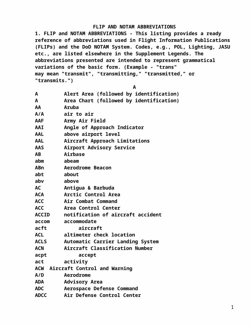
FLIP AND NOTAM ABBREVIATIONS1. FLIP and NOTAM ABBREVIATIONS - This listing provides a ready reference of abbreviations used in Flight Information Publications (FLIPs) and the DoD NOTAM System. Codes, e.g., POL, Lighting, JASU etc., are listed elsewhere in the Supplement Legends. The abbreviations presented are intended to represent grammatical variations of the basic form. (Example - "trans"may mean "transmit", "transmitting," "transmitted," or "transmits.")
AA Alert Area (followed by identification)A Area Chart (followed by identification)AA ArubaA/A air to airAAF Army Air FieldAAI Angle of Approach IndicatorAAL above airport levelAAL Aircraft Approach LimitationsAAS Airport Advisory ServiceAB Airbase abm abeamABn Aerodrome Beaconabt aboutabv aboveAC Antigua & BarbudaACA Arctic Control AreaACC Air Combat CommandACC Area Control CenterACCID notification of aircraft accidentaccom accommodateacft aircraftACL altimeter check locationACLS Automatic Carrier Landing SystemACN Aircraft Classification Numberacpt acceptact activityACW Aircraft Control and WarningA/D AerodromeADA Advisory AreaADC Aerospace Defense CommandADCC Air Defense Control CenterADCF air defense control facilityADCUS Advise CustomsADDC Air Defense Direction Centeraddn additionADF Automatic Direction FinderADIZ Air Defense Identification Zoneadj adjacentadmin administrationADR Advisory Routeadvs advise
1
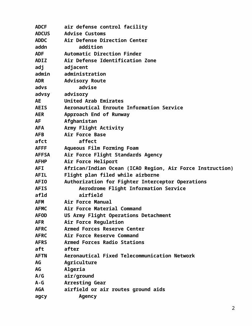
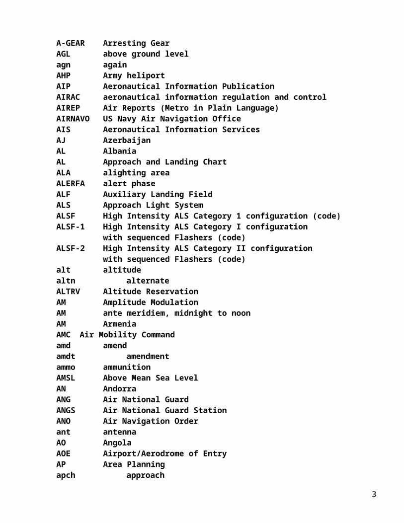
advsy advisoryAE United Arab EmiratesAEIS Aeronautical Enroute Information ServiceAER Approach End of RunwayAF AfghanistanAFA Army Flight ActivityAFB Air Force Baseafct affectAFFF Aqueous Film Forming FoamAFFSA Air Force Flight Standards AgencyAFHP Air Force HeliportAFI African/Indian Ocean (ICAO Region, Air Force Instruction)AFIL Flight plan filed while airborneAFIO Authorization for Fighter Interceptor OperationsAFIS Aerodrome Flight Information Serviceafld airfieldAFM Air Force ManualAFMC Air Force Material CommandAFOD US Army Flight Operations DetachmentAFR Air Force RegulationAFRC Armed Forces Reserve CenterAFRC Air Force Reserve CommandAFRS Armed Forces Radio Stationsaft afterAFTN Aeronautical Fixed Telecommunication NetworkAG AgricultureAG AlgeriaA/G air/groundA-G Arresting GearAGA airfield or air routes ground aidsagcy AgencyA-GEAR Arresting GearAGL above ground levelagn againAHP Army heliportAIP Aeronautical Information PublicationAIRAC aeronautical information regulation and controlAIREP Air Reports (Metro in Plain Language)AIRNAVO US Navy Air Navigation OfficeAIS Aeronautical Information ServicesAJ AzerbaijanAL AlbaniaAL Approach and Landing ChartALA alighting areaALERFA alert phaseALF Auxiliary Landing FieldALS Approach Light SystemALSF High Intensity ALS Category 1 configuration (code)ALSF-1 High Intensity ALS Category I configuration
2
with sequenced Flashers (code)ALSF-2 High Intensity ALS Category II configuration
with sequenced Flashers (code)alt altitudealtn alternateALTRV Altitude ReservationAM Amplitude ModulationAM ante meridiem, midnight to noonAM ArmeniaAMC Air Mobility Commandamd amendamdt amendmentammo ammunitionAMSL Above Mean Sea LevelAN AndorraANG Air National GuardANGS Air National Guard StationANO Air Navigation Orderant antennaAO AngolaAOE Airport/Aerodrome of EntryAP Area Planningapch approachapn apronAPO Air Force or Army Post OfficeAPP CON Approach ControlApr Aprilaprx approximateAPU Auxiliary Power UnitAPV Approach with Vertical Guidanceapv approveapvl approvalAQ American SamoaAR Aerial RefuelingAR ArgentinaAR Army Reserve, Air ReceiveARB Air Reserve BaseARC Area of Responsibility CenterARCAL Aircraft Radio Control (Canada) of Aerodrome LightingARCP Air Refueling Control PointARCT Air Refueling Control TimeARFOR Area ForecastARINC Aeronautical Radio Inc.ARIP Air Refueling Initial Pointarng arrangeARNG Army National GuardARO ATS Reporting OfficeARP Airport Reference Pointarpt airport
3
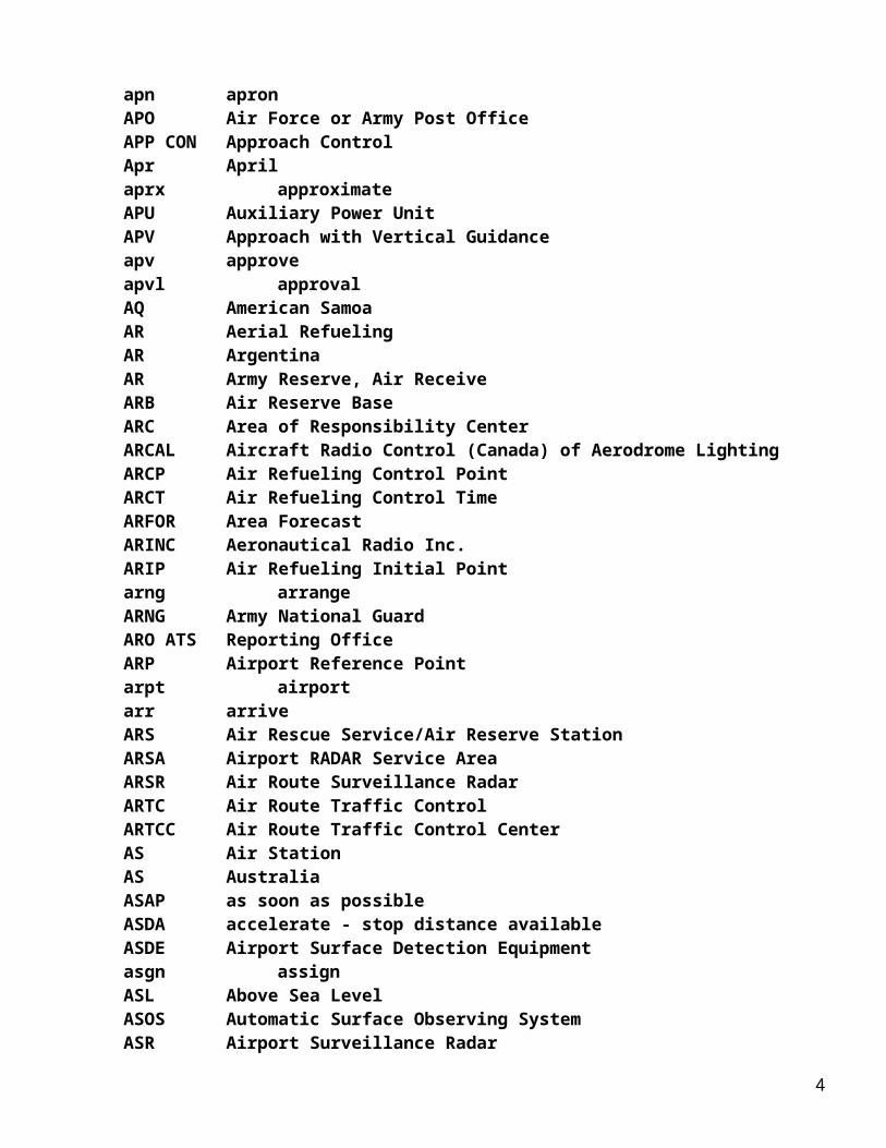
arr arriveARS Air Rescue Service/Air Reserve StationARSA Airport RADAR Service AreaARSR Air Route Surveillance RadarARTC Air Route Traffic ControlARTCC Air Route Traffic Control CenterAS Air StationAS AustraliaASAP as soon as possibleASDA accelerate - stop distance availableASDE Airport Surface Detection Equipmentasgn assignASL Above Sea LevelASOS Automatic Surface Observing SystemASR Airport Surveillance RadarASRgn Altimeter Setting RegionASU Aircraft Starting UnitAT Air TransmitAT Ashmore and Cartier IATA Actual Time of ArrivalATC Air Traffic ControlATC Air Training CommandATCAA Air Traffic Control Assigned AirspaceATCC Air Traffic Control CenterATCOM Air Traffic Control Communications (Ship to Shore)ATCRBS Air Traffic Control Radar Beacon SystemATD Actual Time of DepartureATD Along Track DistanceATF Automatic Terrain FollowingATFM Air Traffic Flow ManagementATIS Automatic Terminal Information ServiceATS Air Traffic Serviceattn attentionATZ airport traffic zoneAU AustriaAug Augustauth authorityauto automaticAUW All Up Weight (gross weight)aux auxiliaryAV AnguillaAVASI abbreviated VASIavbl availableavg averageAvGas aviation gasolineavn aviationAvOil aviation oilavord aviation ordnanceAWOS Automated Weather Observing System
4
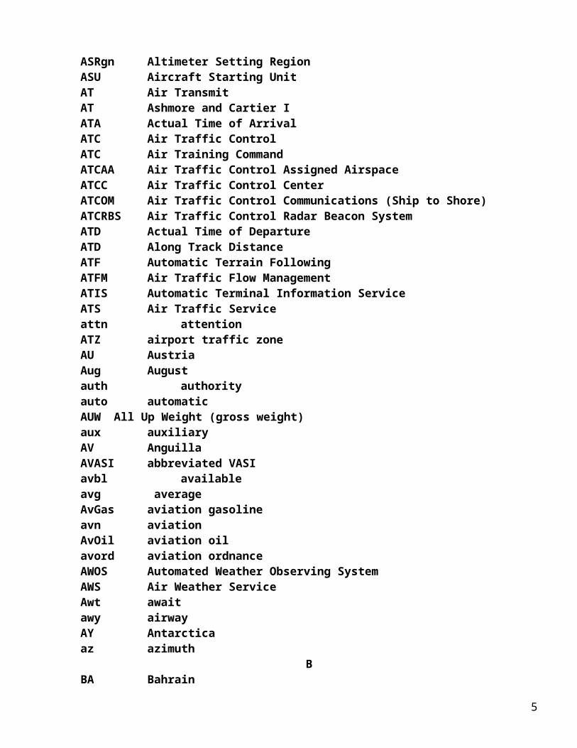
AWS Air Weather ServiceAwt awaitawy airwayAY Antarcticaaz azimuth
BBA BahrainBA braking actionBASH Bird Aircraft Strike HazardBB BarbadosBC back courseBC Botswanabcn beaconbcst broadcastBD Bermudabdry boundaryBE BelgiumBEQ Bachelor Enlisted QuartersBF The BahamasBG BangladeshBH BelizeBK Bosnia and HerzegovinaBKN BrokenBL Boliviabldg buildingblkd blockedblw belowBM bone marker, back markerBM BurmaBN BeninBO BelarusBOA Break-Off AltitudeBOH Break-Off HeightBOQ Bachelor Officers QuartersBP Solomon IBQ Navassa IBR Brazilbrg bearingbrkg brakingBS Broadcast Station (commercial)BT Bhutanbtn betweenBU Bulgariabus businessBV Bouvet IBWC Bird Watch ConditionBX BruneiBY Burundibyd beyond
5
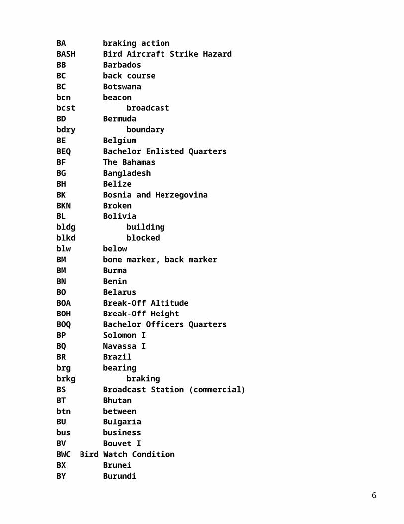
BZ Buffer ZoneC
C Celsius (degrees), Centigrade (degrees)C Center (runway designation)C Circling Approach (on instrument approach chart)C Commercial Circuit (Telephone)CA CanadaCAC Centralized Approach ControlCALS combat assault landing strip cap capacityCAR Caribbean (ICAO Region)CARF Central Altitude Reservation FacilityCAS Calibrated AirspeedCat categoryCAT Clear Air TurbulenceCAVU Ceiling and Visibility UnlimitedCB CambodiaCB Crash BoatCCW or cntclkws counterclockwise CD ChadCDI Course Direction IndicatorCE Sri Lankaceil ceilingCERAP Center Radar Approach ControlCF Congocfm confirmCFMU Central Flow Management UnitCG Democratic Republic of the CongoCGAF Coast Guard Air FacilityCGAS Coast Guard Air StationCH channelCH Chinachan channelCHAPI Chase Helicopter Approach Path Indicatorchg changecht chartCI Chile, Easter Icir circle, circlingCIS Commonwealth of Independent StatesCIRVIS Communications Instructions Reporting Vital Intelligence SightingsCIT near or over large townsciv civil, civilianCJ Cayman Ick checkCK Cocos (Keeling) Icl classCL Centerline Lighting Systemclbr calibrationclnc clearanceCLNC DEL clearance delivery
6
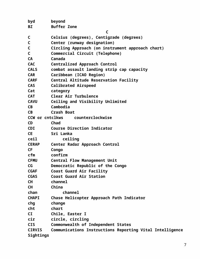
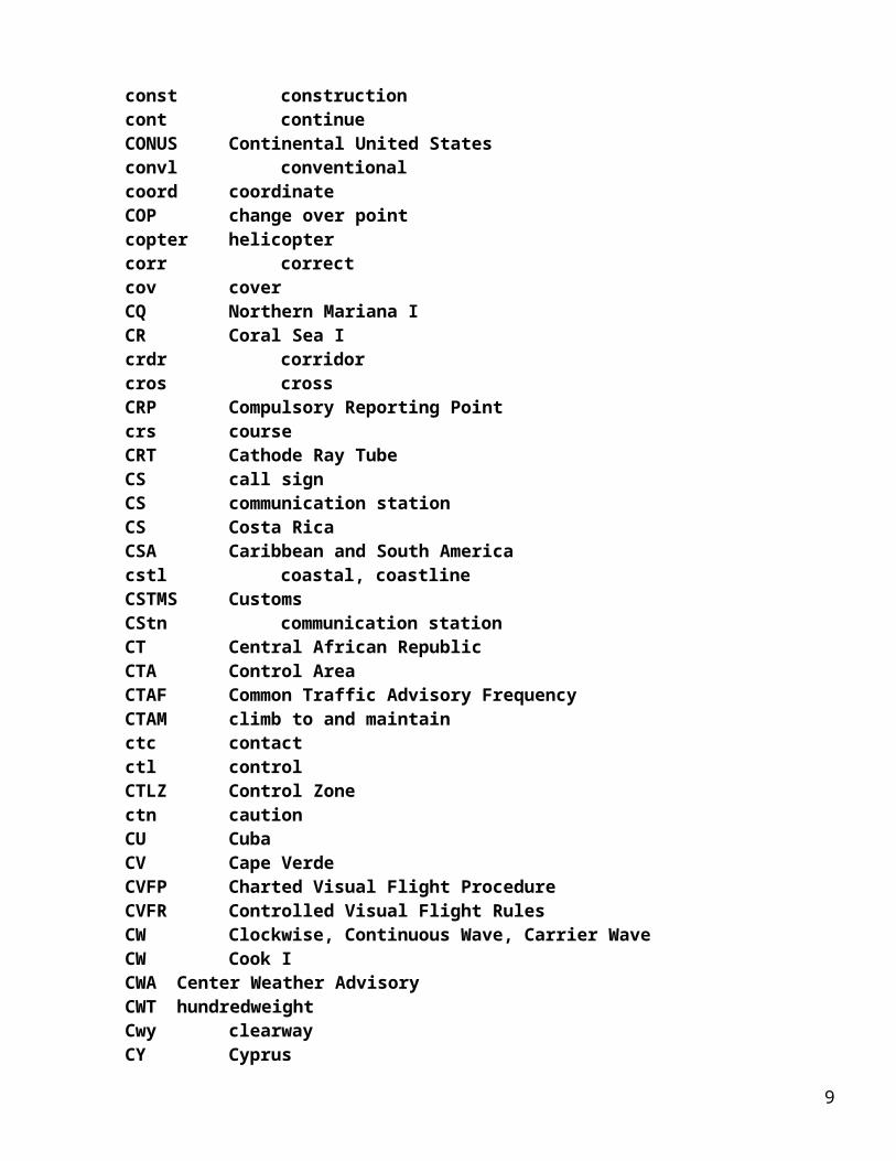
CLR Clearclsd closedCM CameroonCMNPS Canadian Minimum Navigation Performance Specifications Airspacecmsn commissionCN ComorosCNATRA Chief of Naval Air TrainingCNF Computer Navigation Fixcnl cancelCNO Chief of Naval Operationscns continuouscnsld Consolidatedcntclkws counterclockwiseor CCWcntr centercntrln centerlineCO ColombiaCO Commanding OfficerCo Company, Countycom communicationcomd commandComdr Commandercomdt commandantcoml commercialcompl completecompul compulsorycomsn commissionCON Control (voice call), Consol, Consolanconc concretecond conditionconst constructioncont continueCONUS Continental United Statesconvl conventionalcoord coordinateCOP change over pointcopter helicoptercorr correctcov coverCQ Northern Mariana ICR Coral Sea Icrdr corridorcros crossCRP Compulsory Reporting Pointcrs courseCRT Cathode Ray TubeCS call signCS communication stationCS Costa Rica
7
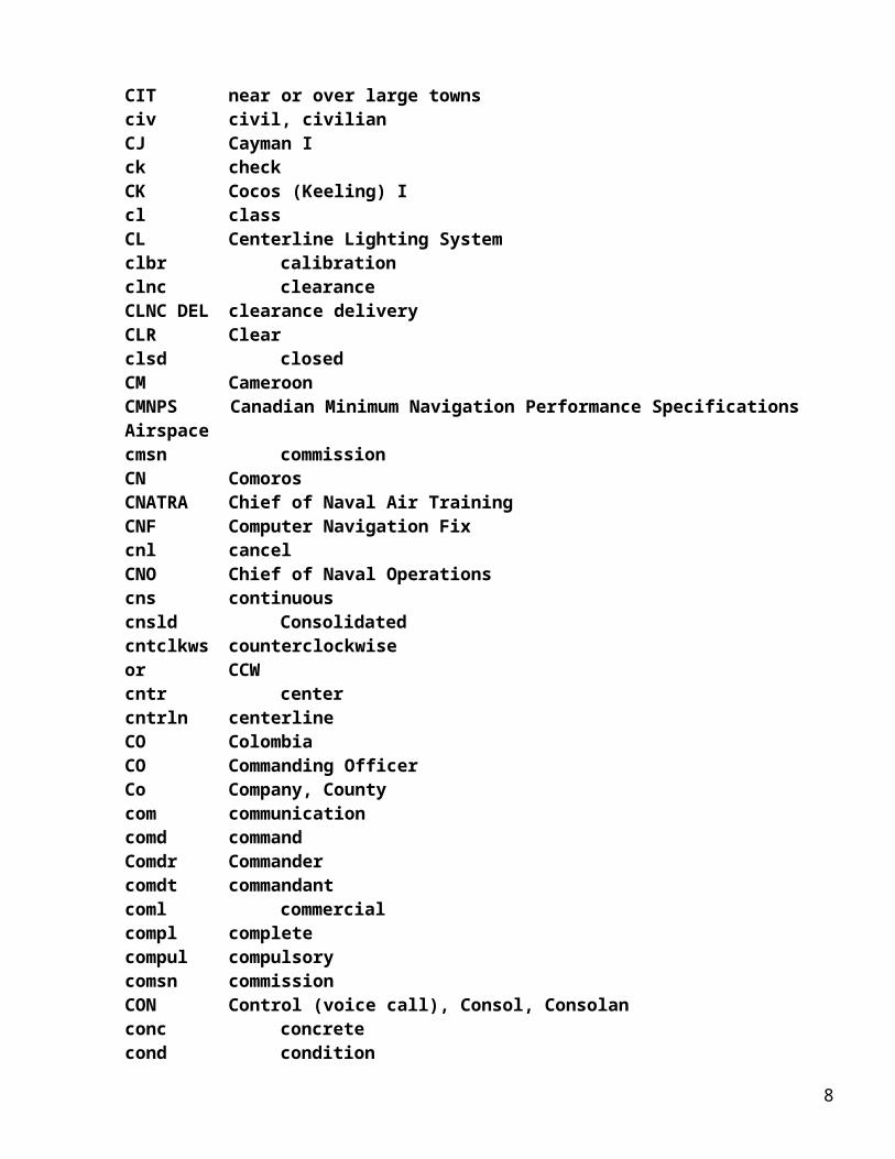
CSA Caribbean and South Americacstl coastal, coastlineCSTMS CustomsCStn communication stationCT Central African RepublicCTA Control AreaCTAF Common Traffic Advisory FrequencyCTAM climb to and maintainctc contactctl controlCTLZ Control Zonectn cautionCU CubaCV Cape VerdeCVFP Charted Visual Flight ProcedureCVFR Controlled Visual Flight RulesCW Clockwise, Continuous Wave, Carrier WaveCW Cook ICWA Center Weather AdvisoryCWT hundredweightCwy clearwayCY Cyprus
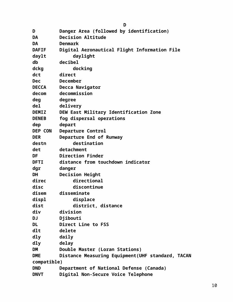
DD Danger Area (followed by identification)DA Decision AltitudeDA DenmarkDAFIF Digital Aeronautical Flight Information Filedaylt daylightdb decibeldckg dockingdct directDec DecemberDECCA Decca Navigator decom decommissiondeg degreedel deliveryDEMIZ DEW East Military Identification ZoneDENEB fog dispersal operationsdep departDEP CON Departure ControlDER Departure End of Runwaydestn destinationdet detachmentDF Direction FinderDFTI distance from touchdown indicatordgr dangerDH Decision Heightdirec directionaldisc discontinue
8
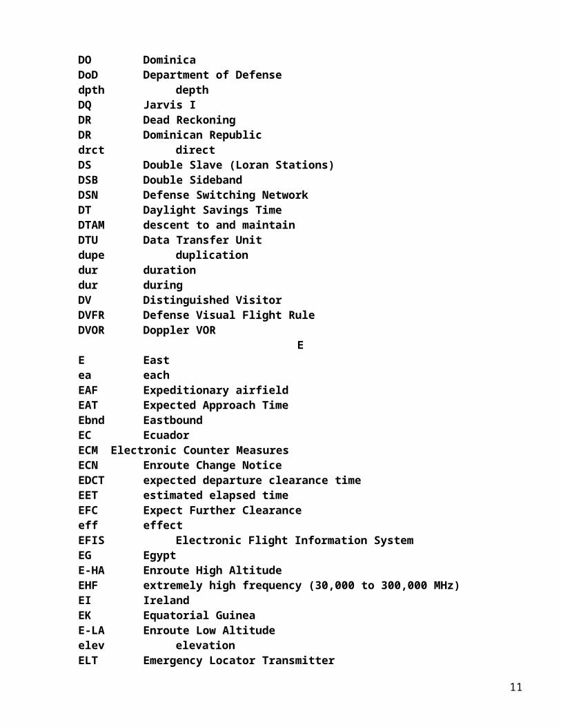
disem disseminatedispl displacedist district, distancediv divisionDJ DjiboutiDL Direct Line to FSSdlt deletedly dailydly delayDM Double Master (Loran Stations)DME Distance Measuring Equipment(UHF standard, TACAN compatible)DND Department of National Defense (Canada)DNVT Digital Non-Secure Voice TelephoneDO DominicaDoD Department of Defensedpth depthDQ Jarvis IDR Dead ReckoningDR Dominican Republicdrct directDS Double Slave (Loran Stations)DSB Double SidebandDSN Defense Switching NetworkDT Daylight Savings TimeDTAM descent to and maintainDTU Data Transfer Unitdupe duplicationdur durationdur duringDV Distinguished VisitorDVFR Defense Visual Flight RuleDVOR Doppler VOR
EE Eastea eachEAF Expeditionary airfieldEAT Expected Approach TimeEbnd EastboundEC EcuadorECM Electronic Counter MeasuresECN Enroute Change NoticeEDCT expected departure clearance timeEET estimated elapsed timeEFC Expect Further Clearanceeff effectEFIS Electronic Flight Information SystemEG EgyptE-HA Enroute High AltitudeEHF extremely high frequency (30,000 to 300,000 MHz)
9
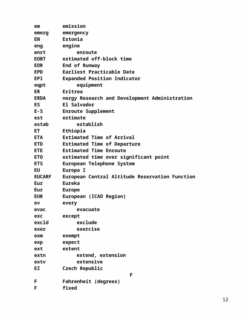
EI IrelandEK Equatorial GuineaE-LA Enroute Low Altitudeelev elevationELT Emergency Locator Transmitterem emissionemerg emergencyEN Estoniaeng engineenrt enrouteEOBT estimated off-block timeEOR End of RunwayEPD Earliest Practicable DateEPI Expanded Position Indicatoreqpt equipmentER EritreaERDA nergy Research and Development AdministrationES El SalvadorE-S Enroute Supplementest estimateestab establishET EthiopiaETA Estimated Time of ArrivalETD Estimated Time of DepartureETE Estimated Time EnrouteETO estimated time over significant pointETS European Telephone SystemEU Europa IEUCARF European Central Altitude Reservation FunctionEur EurekaEur EuropeEUR European (ICAO Region)ev everyevac evacuateexc exceptexcld excludeexer exerciseexm exemptexp expectext extentextn extend, extensionextv extensiveEZ Czech Republic
FF Fahrenheit (degrees)F fixedFA Falkland IFAA Federal Aviation Administrationfac facility
10
FAF Final Approach FixFACSFAC Fleet Area Control and Surveillance FacilityFAR Federal Air RegulationsFARP Forward Arming and Refueling PointFAS Final Approach SpeedFAWS Flight Advisory Weather Servicefax facsimileFBAA Flying Boat Alighting AreaFBO Fixed Base OperatorFBW Fly by WireFCC Flight Control CenterFCG Foreign Clearance GuideFCLP field carrier landing practicefcst forecastFeb FebruaryFG French GuianaFI FinlandFIC Flight Information CenterFIFOR Flight Forecast (in international MET figures)FIH Flight Information HandbookFI/P Flight Inspection PermanentFIR Flight Information RegionFIS Flight Information ServiceFI/T Flight Inspection TemporaryFJ FijiFK Falkland I, incl South Georgia I and South Sandwich IFL flight levelfld fieldflg flashingFLIP Flight Information Publicationflr flareflt flightfltck flight checkFLT CON Flight Controlfluc fluctuateflw followFM Fan Marker, Frequency ModulationFM Federated States of MicronesiaFMP Flow Management PositionFMS Flight Management SystemFMU Flow Management UnitFNA final approachFO Faroe IFOC Flight Operations CenterFOD Foreign Object Damagefone telephoneFP French PolynesiaFPL Flight Planfpm feet per minute
11
FPO Fleet Post OfficeFQ Baker Ifqt frequentFR France, Corsicafr fromfreq frequency, frequentFri Fridayfrng firingFS Flight ServiceFS French Southern and Antarctic IFSC Flight Service CenterFSL full stop landingFSS Flight Service Stationfst firstft footftr fighterfurn furnishF/W Fixed Wing
GG gridGA GambiaGA Glide AngleG/A ground-to-airgal gallonG-,A-,R-,B- Low Frequency Airways (green, amber, red, blue)GAT General Air Traffic (Europe-Asia)GB GabonGCA Ground Controlled ApproachGCAS Ground Collision Avoidance SystemGCI Ground Control InterceptGCO Ground Communications OutletGCT Greenwich Civil Timegen generalGG GeorgiaGH GhanaGI GibraltarGJ GrenadaGK GuernseyGL Greenlandgldr gliderGLS GNSS Landing SystemGM GermanyGMT Greenwich Mean Time (when not a figure of time)gnd groundgndck ground checkGND CON Ground Controlgnry gunneryGNSS Global Navigation Satellite SystemGO Glorioso I
12
govt governmentGP Glide PathGp GroupGP GuadeloupeGPI Ground Point of InterceptGPS Global Positioning SystemGQ GuamGR Greece, Cretegrad gradientgrav gravelgrd guardgrdl gradualGriv GrivationGS glide slopeGT GuatemalaGV Grid variationGV GuineaGWT gross weightGY GuyanaGZ Gaza Strip
HH Enroute High Altitude Chart (followed by identification)H+ Hours or hours plus... minutes past the hourH24 continuous operationHA HaitiHAA Height Above Airport/AerodromeHAL Height Above Landing AreaHALS Helicopter Approach Lighting SystemHAR Height Above RunwayHAT Height Above Touchdownhaz hazardHDF High Frequency Direction Finderhdg headingHDTA High Density Traffic Airport/AerodromeHF High Frequency (3000 to 30,000 KHz)Hg mercuryhgr hangarhgt heightHI Hawaiihi highHi or HA ALT High Altitude HIFOR High Level ForecastHILS Heliport Instrument Lighting SystemHIRL High Intensity Runway LightsHIRTA high intensity radio transmission areaHIWAS Hazardous Inflight Weather Advisory ServiceHJ Sunrise to SunsetHK Hong KongHKSAR Hong Kong Special Administrative Region
13
hldg holdingHM Heard and McDonald IHN Sunset to SunriseHO HondurasHO Service available to meet operational requirementshol holidayHOLF Helicopter Outlying Fieldhoriz horizontalhosp hospitalhPa hectopascalHPOX High Pressure OxygenHPZ Helicopter Protected ZoneHQ HeadquartersHQ Howard IHR Croatiahr hourHS service available during hours of scheduled operationshsg housingHTA Helicopter Training AreaHU HungaryHVDF High and Very High Frequency Direction Finder
(at the same location)hvy heavyHW Heavy Weighthwy highwayHX Station having no specific working hoursHz Hertz (cycles per second)
II islandIACC Inter-Agency Air Cartographic CommitteeIAF Initial Approach FixIAL instrument approach and landing chartIAP Instrument Approach ProcedureIAR intersection of air routesIAS Indicated Air SpeedIATA International Air Transport AssociationIAW in accordance withIBn identification BeaconIC IcelandICAO International Civil Aviation Organizationice icingICLS Instrument Carrier Landing SystemID Indonesiaident identificationIF Intermediate FixIFF Identification, Friend or FoeIFIM International Flight Information Manual.IFPS Integrated Initial Flight Plan Processing SystemIFR Instrument Flight Rules
14
IFR-S FLIP IFR SupplementIFSS International Flight Service StationIGS Instrument Guidance SystemILA Instrument Landing AidILS Instrument Landing SystemIM Inner MarkerIM Isle of Man/RonaldswayIMC Instrument Meteorological ConditionsIMG Immigrationimmed immediatein inchIN IndiaINA initial approachinactv inactiveinad inadvertentinbd inboundINC In CloudInc Incorporatedincl includeINCR INCREASEindef indefiniteinfo informationinop inoperativeINP if not possibleinpr in progressINREQ information requestINS Inertial Navigation Systeminst instrumentinstl installinstr instructionint intersectionintcntl intercontinentalintcp interceptintl internationalintmed intermediateintmt intermittentintrg interrogateintrod introduceintrp interruptints intenseintsf intensifyINTXN Intersection (for Instrument Approach Procedures only)IO British Indian Ocean Territory (Diego Garcia)IP Chipperton IIP Initial PointIR IFR Military Training RouteIR IranIS IsraelISMLS Interim Standard Microwave Landing System
15
isol isolateIT ItalyIV Ivory CoastIZ Iraq
JJ Jet FuelJ Jet Route (followed by identification)JA Japan, Bonin I, Volcano I,Minami-Torishima I, Ryukyu I
and OkinawaJAL High Altitude Instrument Approach Procedure ChartJ-bar jet aircraft barrierJan JanuaryJARB Joint Air Reserve BaseJASU Jet Aircraft Starting UnitJATO Jet Assisted Take-OffJCS Joint Chiefs of StaffJE JerseyJM JamaicaJN Jan MayenJNC Jet Navigation Chartjng joiningJO JordanJOAP Joint Oil Analysis ProgramJOSAC Joint Operational Support Airlift CenterJQ Johnston AtollJRB Joint Reserve Basejtstr jet streamJU Juan De Nova IJul JulyJun June
KK Kopter (spoken ICAO ATS route designator)KE Kenyakg kilogramsKG KyrgyzstankHz kilohertzKIAS Knots Indicated AirspeedKLIZ Korea Limited Identification Zone (KLIZ is also the ICAO
Identifier for LORING AFB, ME)km kilometerkmh kilometers per hourKN Korea, Democratic People’s Republic of (North)KPa KilopascalKQ Kingman ReefKR Kiribati (Butaritari, Canton, Christmas I, and Tarawa)KS Korea, Republic of (South)KT Christmas IKt or K KnotsKU Kuwait
16
kw kilowattKZ Kazakhstan
LL Compass locatorL Enroute Low Altitude Chart (followed by identification)L Left (Runway designation)L Local TimeLA LaosLAAS Low Altitude Alert SystemLAHSO Land And Hold Short OperationsL-AOE Limited Airport of Entrylat latitudelatrl lateralLAWRS Limited Aviation Weather Reporting Station lb pound (weight)lcl localLCN load classification numberLCP French Peripheral Classification Linelctd locatedlctn locationlctr locatorLCVASI Low Cost Visual Approach Slope Indicatorlczr localizerLDA Landing Distance AvailableLDA Localizer-type Directional Aidldg landingLDI landing direction indicatorLDIN Lead-in LightsLE Lebanonlen lengthLF Low Frequency (30 to 300 KHz)LFR Low/Medium Frequency RangeLG Latvialgt lightlgtd lightedLH LithuaniaLHOX Low and High Pressure OxygenLI LiberiaLIH light intensity highLIL light intensity lowLIM light intensity mediumLIRL Low Intensity Runway LightsLLWAS Low-Level Wind Shear Alert SystemLLZ ICAO Localizer (for ICAO Instrument Approach Procedures only)
Note: FAA LOC/LDA parameters are inclusive within ICAO LLZ parameters.LMM Compass locator at Middle Marker ILSLMT Local Mean TimeLNAV Lateral Navigationlo low
17
LO SlovakiaLoALT or LA Low AltitudeLOC Localizer (For Instrument Approach Procedures only)Lo Int Low Intensity LightsLOM Compass locator at Outer Marker ILSlong longitudeLoran Long Range Aid to NavigationLoran DM Loran Double MasterLoran DS Loran Double SlaveLoran M Loran MasterLoran S Loran SlaveLOX Liquid OxygenLP Low PowerLPOX Low Pressure OxygenLQ Palmyra AtollLR Long Range, Lead RadialLRA Landing Rights AirportLRRS Long Range Radar StationLS LiechtensteinLSB lower side bandlt leftLT LesothoLTA Lighter than airltd limitedltr letterltrs litersLU Luxembourglv leaveLY Libyalyr layerLZ landing zone
MM Master (Loran Station)M meters, magnetic (after a bearing)M Military Circuit (Telephone)MA MadagascarMAA Maximum Authorized AltitudeMACC Military Area Control Centermag magneticmag brg magnetic bearingmaint maintain, maintenancemaj majorMALS Medium Intensity Approach Lighting System MALSF MALS with Sequenced FlashersMALSR MALS with Runway Alignment Indicator Lightsmand mandatorymand alt mandatory altitudeMAP Missed Approach PointMar March
18
MARA Military Activity Restricted AreaMARSA Military Authority Assumes Responsibility for Separation of AircraftMASMS Military Airspace Management SystemMATO Military Air Traffic OperationsMATZ Military Aerodrome Traffic Zonemax maximumMB Martiniquemb millibarsMB Mooring BuoysMC MacauMCA Minimum Crossing AltitudeMCAAF Marine Corps Auxiliary Air FacilityMCAAS Marine Corps Auxiliary Air StationMCAB Marine Corps Air BaseMCAC Military Common Area ControlMCAF Marine Corps Air FacilityMCAGCC Marine Corps Air Ground Combat CenterMCALF Marine Corps Auxiliary Landing FieldMCAS Marine Corps Air StationMCB Marine Corps BaseMCC Military Climb CorridorMCOLF Marine Corps Outlying FieldMD MoldovaMDA Minimum Descent AltitudeMDF Medium Frequency Direction FinderMEA Minimum Enroute Altitudemed mediumMEHT Minimum Eye Height over Thresholdmem memorialMET Meteorological, MeteorologyMETAR Aviation Routine Weather Report (in international MET figure code)METRO Pilot-to-Metro voice callMF Mandatory Frequency (Canada)MF MayotteMF Medium Frequency (300 to 3000 KHz)MFA Minimum Flight AltitudeMFA Military Flying Area (Canada)MFS Military Flight ServiceMG Mongoliamgr managerMH MontserratMHDF Medium and High Frequency Direction Finder (at same location)MHVDF Medium, high and very high Frequency Direction Finder (at same location)MHz MegahertzMI MalawiMID/ASIA Middle East/Asia (ICAO Region)MIDIZ Mid-Canada Identification ZoneMIJI Meaconing, Intrusion, Jamming, and Interferencemil military
19
MIL OVRN Military Overrun Lightsmin minimum, minuteMIN MontenegroMIRL Medium Intensity Runway LightsMIS Meteorological Impact Statementmisl missileMK The Former Yugoslav Republic of Macedoniamkr marker (beacon)ML MaliMLS Microwave Landing SystemMM Middle Marker, ILSMMLS Mobile Microwave Landing SystemMNPS Minimum Navigation Performance SpecificationsMN Monacomnt monitorMO MoroccoMOA Military Operations AreaMOC minimum obstruction clearanceMOCA Minimum Obstruction Clearance Altitudemod moderatemod modifyMon Mondaymov moveMP maintenance periodMP Mauritiusmph miles per hour (statute)MQ Midway IMR MauritaniaMR Medium RangeMRA Minimum Reception Altitudemrk mark, markerMSA Minimum Safe Altitudemsg messageMSL Mean sea levelmsn missionMT Maltamt mount, mountainMTA Minimum Terrain Clearance AltitudeMTAF Mandatory Traffic Advisory FrequencyMTC Military Terminal ControlMTCA Military Terminal Control Areamthly monthlyMTOW Maximum Takeoff Weightmtrs, M or m metersMU OmanMUAC Military Upper Area Controlmulti multiplemuni municipalMV Magnetic Variation
20
MV MaldivesMVA Minimum Vectoring AltitudeMVDF Medium and Very High Frequency Direction Finder (at same location)MX MexicoMY MalaysiaMZ Mozambique
NN NorthN/A not applicableNA not authorized (For Instrument Approach Procedure take-off and
alternate MINIMA only.)NAAS Naval Auxiliary Air StationNADC Naval Air DevelopmentCenterNADEP Naval Air DepotNAES Naval Air Engineering StationNAF Naval Air FacilityNALF Naval Auxiliary Landing FieldNALO Naval Air Logistics OfficeNAM North American (ICAO Region)NAR North American Routes for North Atlantic TrafficNAS Naval Air StationNASA National Aeronautics and Space AdministrationNAT North Atlantic (ICAO Region)natl nationalNATO North Atlantic Treaty OrganizationNATOPS Naval Air Training and Operating Proceduresnav navigationnavaid navigation aidNAVFIG Naval Flight Information GroupNAVMTO Navy Material Transportation OfficeNAWC Naval Air Warfare CenterNAWS Naval Air Weapons StationNbnd NorthboundNC New CaledoniaNCRP Non-Compulsory Reporting PointNDB Non-Directional Radio BeaconNE NiueNE Northeastnec necessaryNEW Net Explosives WeightNF Norfolk ING Nigerngt nightNH VanuatuNI NigeriaNGA STL National Geospatial-Intelligence Agency St. LouisNL NetherlandsNM nautical milesnml normal
21
NO NorwayNo or Nr numberNOF International NOTAM OfficeNOLF Navy Outlying FieldNoPT No Procedure Turn Required (procedure turn shall not be
executed without ATC clearance)NORAD North American Aerospace Defense CommandNORDO Lost communications or no radio installed/available in aircraftNOS National Ocean ServiceNOTAM Notice to Airmennot flt ck not flight checkedNOTUN Notice of UnreliabilityNov NovemberNP NepalNPA Non-Precision ApproachNR NauruNr or No numberNS Naval StationNS SurinameNSA Naval Support ActivityNS ABTMT Noise abatementNSF Naval Support Facilitynstd nonstandardNT Netherlands Antillesntc noticeNU NicaraguaNVD Night Vision DevicesNVG Night Vision GogglesNW NorthwestNWC Naval Weapons CenterNWS National Weather ServiceNWS North Warning SystemNZ New Zealand
OO/A On or aboutOAC Oceanic Area Control, Oceanic Area Control CenterOAS obstacle assessment surfaceOAT Operational Air Trafficobsc obscureObsHt obstacle heightobsn observationobst obstructionOCA Obstacle Clearance AltitudeOCA Oceanic Control AreaOCH obstacle clearance heightOCL Obstacle Clearance Limitsocnl occasionalOCon US Outside Continental Limits of USoct octane
22
Oct OctoberODALS Omnidirectional Approach Lighting SystemODO Operations Duty Officeroffl officialOFFL BUS Official business onlyOIC Officer In ChargeOK we agree, correctOLF Outlying FieldOLS Optical Landing SystemOM Outer Marker, ILSONC Operational Navigation ChartOOD Officer Of the DayOPAREA Operating Area op by operating authorityopr operate, operatorOPS OperationsO/R on requestOROCA Off-Route Obstruction Clearance AltitudeORTCA Off-Route Terrain Clearance Altitudeorig originalO/S out of serviceOSV Ocean Station VesselOT other timesotp on topOTR Oceanic Transition RoutesOTS Organized Track SystemOTS Out of ServiceOUT Facility off the air, or operational but not suitable for IFR operations-limitations
explainedoutbd outboundOVC overcastovft overflightovrn overrunOWS Operational Weather SquadronOX OxygenOXRB Oxygen Replacement Bottles
PP Civil Aerodrome available to transient military aircraftP Page (on Area Planning PCN)P PlanningP Prohibited area (followed by identification)PA ParaguayPAC Pacific (ICAO Region)PACAF Pacific Air ForcesPACOM Pacific CommandPALS Precision Approach and Landing Systems (NAVY)PANS Procedures for Air Navigation ServicesPAPI Precision Approach Path IndicatorPAR Precision Approach Radar para paragraph parl parallelpat pattern
23
PAX PassengerPC Pitcairn IPCA Positive Control AreaPCN Pavement Classification NumberPCN Planning Change NoticePCZ Positive Control ZonePDM Periodic Depot MaintenancePE Perupent penetrateperm permanentperms permissionpers personnelPF Paracel IPFC Porous Friction CoursesPG Spratly IPIREP Pilot Report (pertaining to MET conditions)PJE Parachuting Activities/ExercisesPK PakistanP/L plain languagePL PolandPLA practice low approachPLASI Pulse Light Approach Slope Indicatorp-line pole/power linepln planPM PanamaPM Post meridiem, noon til midnightPMSV Pilot-to-Metro ServicePMRF Pacific Missile Range FacilityPN prior noticePNR point of no returnPO Portugal, incl Azores and Maderia IPOB persons on boardPOL Petrol, Oils and LubricantsPOMAR Position Operational Meteorological Aircraft ReportPOMOLA Poor Mans Optical Landing Systemposn positionPP Papua New GuineaPPI Plan Position IndicatorPPR Prior Permission Requiredpps pulse per secondPRA Precision Radar Approach (Instrument Approach Procedures Identification
only)prcht parachuteprecip precipitationpref preferPRESAIR Air Compressorsprev previousprim primaryprk park
24
PRM Precision Runway Monitorpro procedureprob probableproh prohibitedpro tn procedure turnprov provisionalps plusPS Republic of Palaupsia Pounds per square inch Ambientpsig Pounds per square inch Gagepsnl personalPSP Pierced Steel Plankingpt pointptcp participatePTD Pilot to DispatcherPTS Polar Track StructurePU Guinea-Bissaupub publicationpubl publishPV prevailing visibilityPVASI Pulsating Visual Approach Slope Indicatorpvt privatepwr power
QQA QatarQFE Altimeter Setting above stationQNE Altimeter Setting of 29.92 inches which provides height above standard datum
planeQNH Altimeter Setting which provides height above mean sea levelqtrs quartersquad quadrant
RR Ground ReceiveR- radial (followed by 3 digitsfor use on instrument approach charts)R Restricted Area (followed by identification)R Right (runway designation)RA Radio Altimeter setting heightRACON Radar Beaconrad radius, radialRAF Royal Air ForceRAI runway alignment indicatorRAIL Runway Alignment Indicator LightsRAIZ Automated Area Information RespondersRAMCC Regional Air Movement Control CenterRAOB Radiosonde observationR-AOE Regular Airport of EntryRAPCON Radar Approach Control (USAF)RATCF Radar Air Traffic Control Facility (Navy)RB Rescue Boat
25
RBn Radio BeaconRBS Radar Bomb ScoringRCA reach cruise altitudeRCAG Remote Center Air to Ground FacilityRCC Rescue Coordination CenterRCF Radar Control Facility (USAF)RCL runway centerlineRCLS Runway Centerline Light SystemRCO Remote Communications Outletrcpt receptionRCR Runway Condition Readingrcv receivercvr receiverrdo radioRE Reunionrecog recognitionreconst reconstructref referencereful refuelingreg regulation, regularREIL Runway End Identifier Lightsrel reliablerelctd relocatedREP Reporting Pointrepl replacereps repairsreq requestRETIL Rapid Exit Taxiway Indicator LightRFP Replacement Flight Planrg rangeRgn RegionRgnl Regionalrgt rightrlgd realignedRM Republic of the Marshall Irmk remarkRNAV Area Navigationrng range, radio rangeRNP Required Navigation PerformanceRO RomaniaROC rate of climbROFOR Route Forecast (in international MET figure code)RON Remain OvernightRot Lt or Bcn Rotating Light or BeaconRP PhilippinesRPI Runway Point of Interceptrpt repeatrpt reportRQ Puerto Rico
26
rqr requireRR RailroadRRL Runway Remaining LightsRRP Runway Reference PointRS RussiaRSC Rescue Sub-CenterRSDU Radar Storm Detection UnitRSP Responder (beacon)RSR Route Surveillance RadarRSRS Reduced Same Runway Separationrstd restrictedR/T RadiotelephonyRTB Return to Baserte routeRTF RadiotelephoneRTG radio telegraphRTR Remote Transmitter ReceiverRTT radio teletypewriterruf roughrufness roughnessRV Rescue VesselRVR Runway Visual RangeRVSM Reduced Vertical Separation MinimaR/W Rotary/WingRW Rwandarwy runway
SS Straight-in-Approach (on instrument approach charts)S Slave (Loran Stations)S SouthS Supersonic (spoken ICAO ATS route designator)SA Saudi ArabiaSAFE-BAR Safeland BarrierSALS Short Approach Lighting SystemSALSF SALS with Sequenced FlasherSAM South American (ICAO Region)SAM Special Air Missionsan sanitarySAR Search and RescueSAR Special Administrative RegionSARA Search and Rescue AidSARPS Standards and Recommended Practices Sat Saturdaysatfy satisfactorySAVASI Simplified Abbreviated Visual Approach Slope IndicatorSAWRS Supplemental Aviation Weather Reporting StationSB St. Pierre & MiquelonSBA Standard Beam ApproachSbnd Southboundsby standby
27
SC St. Kitts & NevisSCATANA Security Control of Air Traffic and Air Navigational AidsSched scheduled servicesSCT Scatteredsctr sectorS/D SeadromeSDF Simplified Directional FacilitySE SeychellesSE Southeastsec second, sectionsecd secondaryseg segmentSELCAL Selective Calling SystemSEng Single EngineSep Septembersepn separationSES Senior Executive ServiceSF South AfricaSFA Single Frequency Approachsfc surfaceSFL Sequence Flashing LightsSFO Simulated FlameoutSG Senegalsgl signalSH St. Helena, incl Ascension ISHAPE Supreme Headquarters Allied Powers EuropeSHF Super High Frequency (3000 to 30000 MHz)SI SloveniaSIAP Standard Instrument Approach ProcedureSID Standard Instrument DepartureSIF Selective Identification Featuresimul simultaneouslySIZ Security Identification Zonesked scheduleSL Sierra LeoneSM San MarinoSM statute milesSMC surface movement controlSMR surface movement radarSN SingaporeSO SomaliaSOAP Spectrometric Oil Analysis ProgramSOF Supervisor of FlyingSP Spain, incl Canary ISR Short RangeSR Slow Speed Low Altitude Training RouteSR SunriseSRE Surveillance Radar Element of GCA (Instrument Approach Procedures
Identification only)
28
SRR search and rescue regionSRS Substitute Route StructureSS SunsetSSALF Simplified Short ALS with sequenced flashersSSALS/R Simplified Short Approach Lighting System/with RAILSSB Single SidebandSSR Secondary Surveillance RadarSST Supersonic TransportST St. LuciaSTAR Standard Terminal Arrival std standardstn stationSTOL Short Take-Off and Landingstor storagestr-in Straight-instu studentSU Sudansubj subjectsum summerSun Sundaysur surroundsurvl survival, surveillancesuspd suspendedSV Svalbardsvc servicesvcbl serviceablesvcg servicingSVFR Special Visual Flight RulesSW SouthwestSW Swedenswy stopwaysxn sectionSY Syriasys systemSZ Switzerland
TT Ground TransmitT Terminal Area Chart (followed by identification)T True (after a bearing)TA Transition AltitudeTA Transition Area (for chart use only)TAC TACAN (For Instrument Approach Procedures Only)TACAN Tactical Air Navigation EquipmentTAF Aerodrome (terminal or alternate) forecast in abbreviated formTAFOR Aerodrome (terminal or alternate) forecast in full formTAFOT Aerodrome Forecast in Units of English SystemTALCE Tanker Airlift Control ElementTAMET Aerodrome Forecast in Units of Metric SystemTAR Terminal Area Surveillance Radar (for NOTAM use only)
29
TAS True AirspeedTBA to be activatedTBI to be inactivatedTCA Terminal Control AreaTCH Threshold Crossing HeightTCN Terminal Change NoticeTCTA Transcontinental Control AreaTD TouchdownTD TransponderTD Trinidad and TobagoTDWR Terminal Doppler Weather RadarTDZ Touchdown ZoneTDZE Touchdown Zone Elevation (For Instrument Approach Procedures Only)TDZL Touchdown Zone LightsTE Tromelin Itemp temperatureTF Terrain Followingtfc trafficTFR Terrain Following RadarTGL touch and go landingTGS taxiway guidance systemTH ThailandT-HA Terminal High Altitude (FLIP)thld thresholdthou thousandTHRE Threshold elevationthru throughThu ThursdayTI Tajikistantil untilTK Turks and Caicos Itkof takeoffTL TokelauT-LA Terminal Low Altitude (FLIP)TLa Transition LayerTLv Transition Leveltmpry temporaryTN TongaTO TogoTOC tactical operations centerTODA Take-off Distance AvailableTORA Take-off Run AvailableTP Sao Tome and PrincipeTP Tire PressureTPC Tactical Pilotage Charttr trackTRA Temporary Reserved AirspaceTRACON Terminal Radar Approach Control (FAA)tran transient
30
trans transmittrml terminaltrng trainingtrns transitionTRSA Terminal Radar Service AreaT-S Terminal Seaplane (FLIP)TS TunisiaTSA Temporary Segregated AirspaceTT East TimorTT teletypeTU TurkeyTue Tuesdayturb turbulenceTV TelevisionTV Tuvalu ITW Taiwantwd towardTWEB Transcribed Weather Broadcasttwr towerTWX Telegraphic Messagetwy taxiwaytwyl taxiway linkTX TurkmenistanTZ United Republic of Tanzania
UU Upper (spoken ICAO ATS route designator)UAB until advised byUACC Upper Area Control Center (used outside US)UAR Upper Air RouteUC under construction (for chart use only)UCN Urgent Change NoticeUDA Upper Advisory AreaUDF Ultra High Frequency Direction FinderUFA until further advisedUFN until further noticeUG UgandaUHF Ultra High Frequency (300 to 3000 MHz)UIC Upper Information CenterUIR Upper Flight Information RegionUK United Kingdomunauthd unauthorizedunavbl unavailableunctl uncontrolledunk unknownunlcig unlimited ceilingunlgtd unlightedunltd unlimitedunmrk unmarkedunmto unmonitored
31
unrel unreliableunrstd unrestrictedunsatfy unsatisfactoryunsked unscheduledunsvc unserviceableunuse unusableUP UkraineUS United StatesUSA United States Army, United States of AmericaUSAF United States Air ForceUSAFE United States Air Force in EuropeUSAFIB US Army Flight Information BulletinUSAP US Antarctic ProgramUSB Upper Side BandUSBER US Mission BerlinUSCG United States Coast GuardUSMC United States Marine CorpsUSMTM US Military Training MissionUSN United States NavyUSNOF US NOTAM FacilityUTA Upper Control AreaUTC Coordinated Universal TimeUTRACC USAFE Tanker Recce Airlift Control CenterUV Burkina FasoUY UruguayUZ Uzbekistan
VV Defense Switching Network (telephone formerly AUTOVON)V VOR Federal Airway (followed by identification)VAL Visiting Aircraft Linevar magnetic variationVASI Visual Approach Slope IndicatorVC St. Vincent and the GrenadinesVCIA Vehicle Component Impact Areavcnty vicinityVDA Vertical Descent AngleVDF Very High Frequency Direction FinderVDP visual descent pointVE Venezuelaveh vehiclevert verticalVFC Visual Flight ConditionsVFR Visual Flight RulesVFR-S FLIP VFR SupplementVGSI Visual Glide Slope Indicating SystemVHF Very High Frequency (30 to 300 MHz)VI Virgin I (UK)via by way ofVIP Very Important Person
32
vis visibilityVLF Very Low FrequencyVM VietnamVMC Visual Meteorological ConditionsVNAV Vertical NavigationVOLMET Meteorological Information for Aircraft in FlightVOR VHF OmnirangeVORTAC VOR and TACAN Navigational Facilities - collocatedVOT VOR receiver testing facilityVQ Virgin I (US)VR VFR Military Training Routevrb variablevsp vertical speedV/STOL Vertical and Short Take-Off and Landing aircraftVT Vatican CityVTOL vertical takeoff and landingV/V Vertical Velocity
WW Warning Area (followed by identification)W Watts, West, WhiteWA NamibiaWAAS Wide Area Augmentation SystemWAC World Aeronautical Chartwbar with bar lightsWbnd WestboundWDI wind direction indicatorwdspr widespreadWE West BankWed WednesdayWEF With Effect FromWEF Effective FromWEPS WeaponsWF Wallis and Futuna IWg WingWGS World Geodetic SystemWI Western Saharawi withinwid widthWIE with immediate effectwin winterWIP work in progresswk weekwkd weekdaywkend weekendwkly weeklywng warningwo withoutWPM Words per minuteWPT waypoint (RNAV)
33
WQ Wake IWS Western SamoaWSP Weather System Processorwt weightW/T Wireless Telegraphywx weatherWxR Weather RadarWZ Swaziland
Xx crossxbar crossbar
YY YellowYCZ yellow caution zoneyd yardYG Yellow-Green BeaconYI Serbia and MontenegroYM Yemenyr year
ZZ Greenwich Mean Time (time groups only)Z VHF Station Location MarkerZA ZambiaZI ZimbabweZI Zone of Interior
34