Embed Size (px)
Citation preview
Aviation Safety Information Analysis and Sharing
Wrong Runway Departures
July 2007
Aviation Safety Information Analysis and Sharing (ASIAS) Office of Aviation Safety, AVS–4 800 Independence Avenue SW.
Room 1006 Washington, DC 20591
Phone Number: (202) 493–4247 Fax Number: (202) 267–5600
E-mail: [email protected]
Wrong Runway Departures iii
TABLE OF CONTENTS
List of Figures ...................................................................................................... iv
Abbreviations and Acronym List ........................................................................... v
Executive Summary ............................................................................................ vii
Introduction ...........................................................................................................1 Background...................................................................................................................1 Scope of This Report ....................................................................................................2
Events Analysis.....................................................................................................3 Data Sources ................................................................................................................3 Part 121 Operators........................................................................................................4 Part 129 and 135 Operators........................................................................................12 Part 91 Operators........................................................................................................13 Mitigations...................................................................................................................14
NOTAM Process .................................................................................................25
Part 139 Airport Contributing Factors Study .......................................................27 Scope of the Study......................................................................................................27 Wrong Runway Event Threats ....................................................................................27
Conclusions and Recommendations...................................................................29
Appendix A — Subject Matter Expert Panel .................................................... A–1
Appendix B — JIMDAT Mitigation Scoring Table............................................. B–1
Appendix C — NOTAM Process...................................................................... C–1
Appendix D — Part 139 Airport Threat Matrix.................................................. D–1
iv Wrong Runway Departures
LIST OF FIGURES
Figure 1. Blue Grass Airport ................................................................................1
Figure 2. Percent of Part 121 Event Reports By Database..................................4
Figure 3. Part 121 Wrong Runway Events by Airport (1981 – 2006) (80 Events Scored by JIMDAT)...............................................................................................6
Figure 4. Example of Multiple Runway Ends in the Same Location (Salt Lake City International Airport) ......................................................................................7
Figure 5. Wrong Runway Contributing Factors Citations .....................................8
Figure 6. Cleveland Hopkins International Airport................................................9
Figure 7. St. Louis Lambert International Airport (Accident Event) ....................10
Figure 8. St. Louis Lambert International Airport (Incident Event) .....................11
Figure 9. Houston Hobby Airport........................................................................12
Figure 10. Ted Stevens Anchorage International Airport ...................................13
Figure 11. Logic Diagram Mathematical Model..................................................18
Figure 12. JIMDAT Scoring of Risk Eliminated by Wrong Runway Safety Enhancements....................................................................................................19
Figure 13. Cleveland Hopkins International Airport (Taxiway T Shown in Orange)...............................................................................................................22
Figure 14. Percentage of Part 139 Airports With Associated Wrong Runway Threat Areas .......................................................................................................28
Figure C–1. NOTAMs by Type and Who Initiates the NOTAM for What Type of Action............................................................................................................... C–3
Figure C–2. NOTAM Flow............................................................................... C–4
Figure C–3. NOTAM Issuance and Distribution .............................................. C–5
Figure C–4. Flight Data Center NOTAMs ....................................................... C–6
Wrong Runway Departures v
ABBREVIATIONS AND ACRONYM LIST
AIDS FAA Accident Incident Data System AIM Aeronautical Information Management AIXM Aeronautical Information Exchange Model ALPA Air Line Pilots Association, International AMASS Airport Movement Area Safety System ANC Ted Stevens Anchorage International Airport APO FAA Aviation Policy and Plans ARTCC Air Route Traffic Control Center ASAP Aviation Safety Action Program ASDE–3 Airport Surface Detection Equipment — Model 3 ASDE–X Airport Surface Detection Equipment — Model X ASDE–3X Airport Surface Detection Equipment — Model 3X ASRS NASA Aviation Safety Reporting System ATADS Air Traffic Activity Data System ATC air traffic control ATIS Automatic Terminal Information Service ATO FAA Air Traffic Organization CLE Cleveland Hopkins International Airport CRM crew resource management EFB electronic flight bag EOSL End of Service Life FAA Federal Aviation Administration FAROS Final Approach Runway Occupancy Signal FDC Flight Data Center FSS flight service station GAJSC General Aviation Joint Safety Council HOU Houston Hobby Airport JIMDAT Joint Implementation Measurement Data Analysis Team MIA Miami International Airport NADIN National Airspace Data Interchange Network NASA National Aeronautics and Space Administration NOTAM Notice To Airmen NPTRS FAA National Program Tracking and Reporting Subsystem NTSB National Transportation Safety Board OE/D Operational Error or Operational Deviation OEDS FAA Operational Error/Deviation System
vi Wrong Runway Departures
OEP Operational Evolution Plan PDS FAA Pilot Deviation System RAAS Runway Awareness and Advisory System RSAT Runway Safety Action Team RSL runway status light SLC Salt Lake City International Airport SME subject matter expert TIPH Taxi Into Position and Hold VPDS Vehicle Pedestrian Deviation System WILD Wildlife Database WMSCR Weather Message Switching Center Replacement
Wrong Runway Departures vii
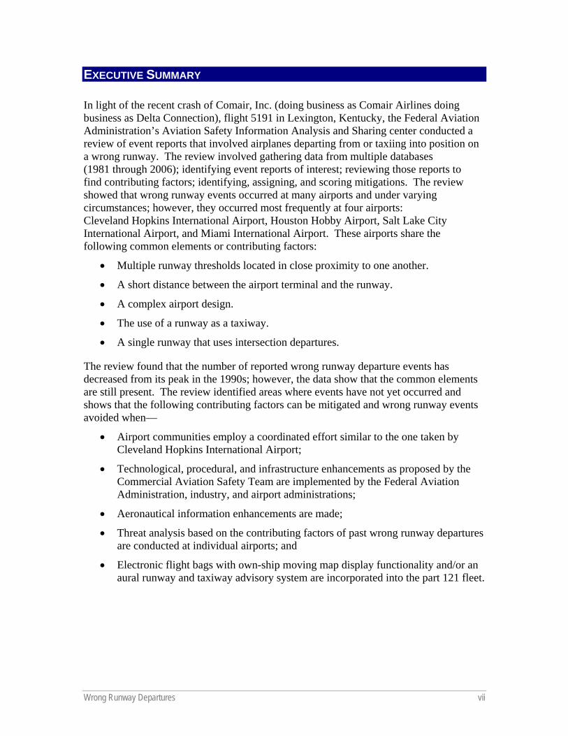
EXECUTIVE SUMMARY
In light of the recent crash of Comair, Inc. (doing business as Comair Airlines doing business as Delta Connection), flight 5191 in Lexington, Kentucky, the Federal Aviation Administration’s Aviation Safety Information Analysis and Sharing center conducted a review of event reports that involved airplanes departing from or taxiing into position on a wrong runway. The review involved gathering data from multiple databases (1981 through 2006); identifying event reports of interest; reviewing those reports to find contributing factors; identifying, assigning, and scoring mitigations. The review showed that wrong runway events occurred at many airports and under varying circumstances; however, they occurred most frequently at four airports: Cleveland Hopkins International Airport, Houston Hobby Airport, Salt Lake City International Airport, and Miami International Airport. These airports share the following common elements or contributing factors:
• Multiple runway thresholds located in close proximity to one another.
• A short distance between the airport terminal and the runway.
• A complex airport design.
• The use of a runway as a taxiway.
• A single runway that uses intersection departures.
The review found that the number of reported wrong runway departure events has decreased from its peak in the 1990s; however, the data show that the common elements are still present. The review identified areas where events have not yet occurred and shows that the following contributing factors can be mitigated and wrong runway events avoided when—
• Airport communities employ a coordinated effort similar to the one taken by Cleveland Hopkins International Airport;
• Technological, procedural, and infrastructure enhancements as proposed by the Commercial Aviation Safety Team are implemented by the Federal Aviation Administration, industry, and airport administrations;
• Aeronautical information enhancements are made;
• Threat analysis based on the contributing factors of past wrong runway departures are conducted at individual airports; and
• Electronic flight bags with own-ship moving map display functionality and/or an aural runway and taxiway advisory system are incorporated into the part 121 fleet.

Wrong Runway Departures 1
INTRODUCTION
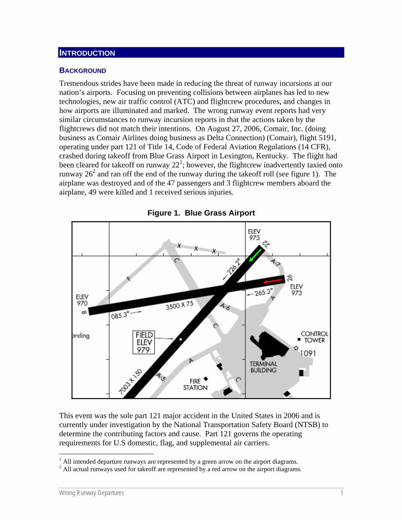
BACKGROUND Tremendous strides have been made in reducing the threat of runway incursions at our nation’s airports. Focusing on preventing collisions between airplanes has led to new technologies, new air traffic control (ATC) and flightcrew procedures, and changes in how airports are illuminated and marked. The wrong runway event reports had very similar circumstances to runway incursion reports in that the actions taken by the flightcrews did not match their intentions. On August 27, 2006, Comair, Inc. (doing business as Comair Airlines doing business as Delta Connection) (Comair), flight 5191, operating under part 121 of Title 14, Code of Federal Aviation Regulations (14 CFR), crashed during takeoff from Blue Grass Airport in Lexington, Kentucky. The flight had been cleared for takeoff on runway 221; however, the flightcrew inadvertently taxied onto runway 262 and ran off the end of the runway during the takeoff roll (see figure 1). The airplane was destroyed and of the 47 passengers and 3 flightcrew members aboard the airplane, 49 were killed and 1 received serious injuries.
Figure 1. Blue Grass Airport
This event was the sole part 121 major accident in the United States in 2006 and is currently under investigation by the National Transportation Safety Board (NTSB) to determine the contributing factors and cause. Part 121 governs the operating requirements for U.S domestic, flag, and supplemental air carriers. 1 All intended departure runways are represented by a green arrow on the airport diagrams. 2 All actual runways used for takeoff are represented by a red arrow on the airport diagrams.
2 Wrong Runway Departures
Following the Comair accident, the Federal Aviation Administration (FAA) Aviation Safety Information Analysis and Sharing (ASIAS) center initiated a preliminary review of several databases to determine the extent of the wrong runway departure issue. Because of the significant number of identified relevant event reports, the ASIAS center undertook a study of wrong runway departures. This study involved gathering wrong runway event reports from many databases (dated 1981 through 2006) and reviewing the data with a panel of subject matter experts (SMEs), in conjunction with the Commercial Aviation Safety Team (CAST), to determine if the event report was applicable to the study, and to identify any contributing factors to the wrong runway events. The panel then proposed mitigations, which were scored by the Joint Implementation Measurement Data Analysis Team (JIMDAT), working for the CAST, which is comprised of Government and industry executives.
SCOPE OF THIS REPORT This report focuses on the analysis of wrong runway departure events for part 121 operators that have occurred in the United States and proposes mitigations to reduce the risk of airplanes departing on the wrong runway. The preliminary review of wrong runway events related to operators operating under the following regulations also are summarized in this report and a more detailed study is currently underway:
• 14 CFR part 135, Operating Requirements: Commuter and On Demand Operations and Rules Governing Persons On Board Such Aircraft;
• 14 CFR part 129, Operations: Foreign Air Carriers and Foreign Operators of U.S.-Registered Aircraft Engaged In Common Carriage; and
• 14 CFR part 91, General Operating and Flight Rules.
This report is divided into three sections. The first section discusses the analysis of the wrong runway events and includes contributing factors, proposed mitigations, and examples. The second section describes, in general, the NOTAM process and how inconsistencies in that process may be a contributing factor to wrong runway events. A third section provides information on a study of 14 CFR part 139 class I airports undertaken to determine which airports have the common wrong runway contributing factors. Part 139 governs the certification of airports. This study attempted to find areas where events have not yet occurred to identify and fix threat areas before a wrong runway event does occur.
In addition, the report contains four appendixes. Appendix A is a list of the SMEs who helped with the analysis of event data. Appendix B presents the JIMDAT mitigation scoring table. Appendix C presents a visual description of the NOTAM process. Finally, appendix D shows the scoring table related to the part 139 airport contributing factors study.
Wrong Runway Departures 3
EVENTS ANALYSIS
DATA SOURCES The analytical process to generate proposed mitigations required a unique approach because departures from a wrong runway are not required to be reported to the FAA under any reporting and data collection program if there is no loss of separation or associated accident event. This made it difficult to obtain a pure data set of all of these events; instead, an effort was made to collect as many relevant reports as possible. Therefore, queries were designed to search both fixed field and free text forms from the following databases:
• National Transportation Safety Board,
• FAA Pilot Deviation System (PDS),
• FAA Accident/Incident Data System (AIDS),
• National Aeronautics and Space Administration (NASA) Aviation Safety Reporting System (ASRS),
• FAA National Program Tracking and Reporting Subsystem (NPTRS), and
• FAA Operational Error/Deviation System (OEDS).
The NTSB data was collected using the “Wrong Runway” subject code and “Takeoff” flight phase. Similarly, PDS data were focused on “Surface Deviations” that pertained to wrong runway takeoffs. The narrative fields for AIDS, ASRS, NPTRS, and OEDS were searched to find wrong runway departures. This approach was used because of the lack of subject or type of event categories in these databases and inconsistencies in event classifications. These queries captured events that involved airplanes departing from, or taxiing into position on, the wrong runway.
The database queries identified 696 event reports of interest. Seventy-nine of these event reports did not identify which part of 14 CFR the flight was operating under at the time of the incident or accident; the panel omitted those reports from the analysis. The remaining event reports were grouped according to which part of the regulations the flight was operating under at the time of the event, as follows:
• 117 event reports from part 121 air carriers,
• 53 event reports from part 135 operators,
• 7 event reports from part 129 air carriers, and
• 440 event reports from part 91 operators.
4 Wrong Runway Departures
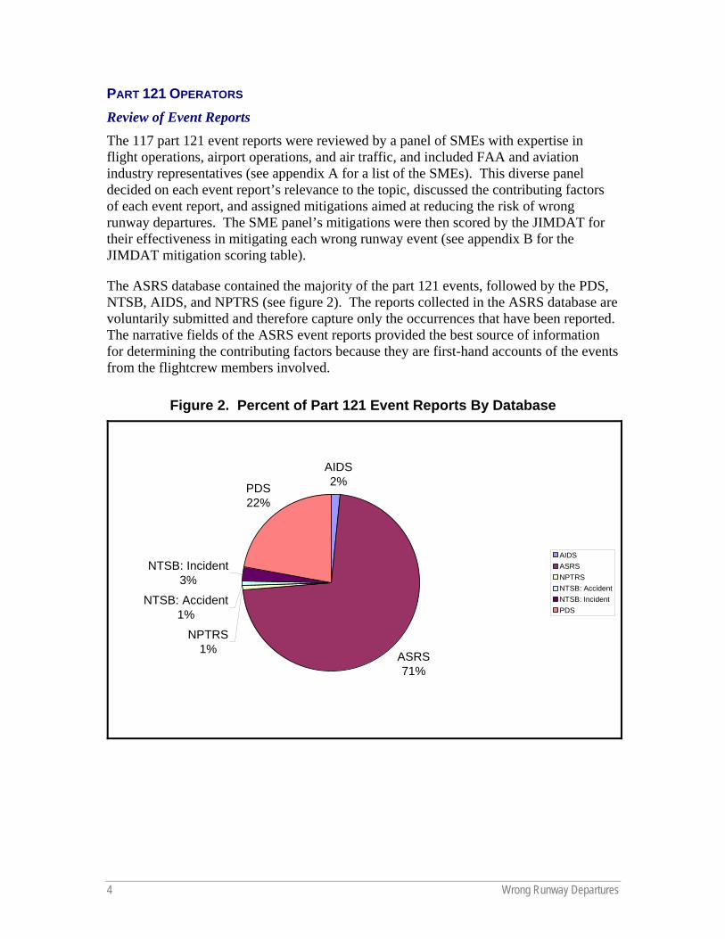
PART 121 OPERATORS Review of Event Reports The 117 part 121 event reports were reviewed by a panel of SMEs with expertise in flight operations, airport operations, and air traffic, and included FAA and aviation industry representatives (see appendix A for a list of the SMEs). This diverse panel decided on each event report’s relevance to the topic, discussed the contributing factors of each event report, and assigned mitigations aimed at reducing the risk of wrong runway departures. The SME panel’s mitigations were then scored by the JIMDAT for their effectiveness in mitigating each wrong runway event (see appendix B for the JIMDAT mitigation scoring table).
The ASRS database contained the majority of the part 121 events, followed by the PDS, NTSB, AIDS, and NPTRS (see figure 2). The reports collected in the ASRS database are voluntarily submitted and therefore capture only the occurrences that have been reported. The narrative fields of the ASRS event reports provided the best source of information for determining the contributing factors because they are first-hand accounts of the events from the flightcrew members involved.
Figure 2. Percent of Part 121 Event Reports By Database
AIDS2%
ASRS71%
NPTRS1%
NTSB: Accident1%
NTSB: Incident3%
PDS22%
AIDSASRSNPTRSNTSB: AccidentNTSB: IncidentPDS
Wrong Runway Departures 5
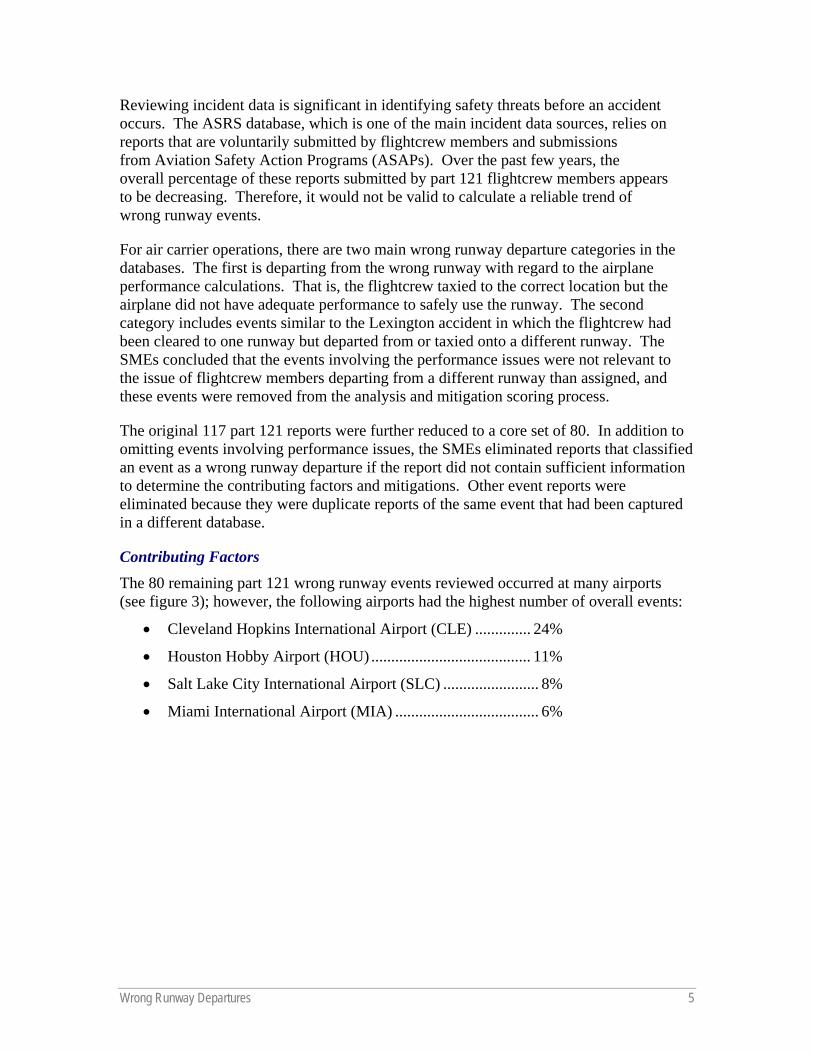
Reviewing incident data is significant in identifying safety threats before an accident occurs. The ASRS database, which is one of the main incident data sources, relies on reports that are voluntarily submitted by flightcrew members and submissions from Aviation Safety Action Programs (ASAPs). Over the past few years, the overall percentage of these reports submitted by part 121 flightcrew members appears to be decreasing. Therefore, it would not be valid to calculate a reliable trend of wrong runway events.
For air carrier operations, there are two main wrong runway departure categories in the databases. The first is departing from the wrong runway with regard to the airplane performance calculations. That is, the flightcrew taxied to the correct location but the airplane did not have adequate performance to safely use the runway. The second category includes events similar to the Lexington accident in which the flightcrew had been cleared to one runway but departed from or taxied onto a different runway. The SMEs concluded that the events involving the performance issues were not relevant to the issue of flightcrew members departing from a different runway than assigned, and these events were removed from the analysis and mitigation scoring process.
The original 117 part 121 reports were further reduced to a core set of 80. In addition to omitting events involving performance issues, the SMEs eliminated reports that classified an event as a wrong runway departure if the report did not contain sufficient information to determine the contributing factors and mitigations. Other event reports were eliminated because they were duplicate reports of the same event that had been captured in a different database.
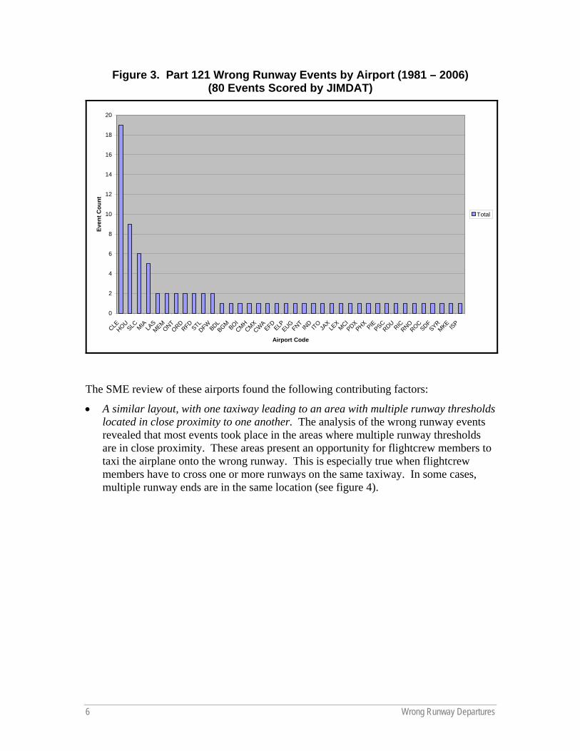
Contributing Factors The 80 remaining part 121 wrong runway events reviewed occurred at many airports (see figure 3); however, the following airports had the highest number of overall events:
• Cleveland Hopkins International Airport (CLE) .............. 24%
• Houston Hobby Airport (HOU) ........................................ 11%
• Salt Lake City International Airport (SLC) ........................ 8%
• Miami International Airport (MIA) .................................... 6%
6 Wrong Runway Departures
Figure 3. Part 121 Wrong Runway Events by Airport (1981 – 2006) (80 Events Scored by JIMDAT)
0
2
4
6
8
10
12
14
16
18
20
CLEHOU
SLC MIA LASMEM
ONTORD
RFDSTL
DFWBDL
BGM BOICMH
CMXCW
AEFD
ELPEUG
FNTIN
DITO
JAX
LEX
MCIPDX
PHX PIEPSC
RDURIC
RNOROC
SDFSYR
MKEISP
Airport Code
Even
t Cou
nt
Total
The SME review of these airports found the following contributing factors:
• A similar layout, with one taxiway leading to an area with multiple runway thresholds located in close proximity to one another. The analysis of the wrong runway events revealed that most events took place in the areas where multiple runway thresholds are in close proximity. These areas present an opportunity for flightcrew members to taxi the airplane onto the wrong runway. This is especially true when flightcrew members have to cross one or more runways on the same taxiway. In some cases, multiple runway ends are in the same location (see figure 4).

Wrong Runway Departures 7
Figure 4. Example of Multiple Runway Ends in the Same Location (Salt Lake City International Airport)
• A short distance between the airport terminal and the runway. A short distance between the terminal and the runway requires flightcrews to complete the same number of checklist items in a shorter timeframe and requires more heads-down time during taxi. Many of the event reports mentioned that the flightcrew members were rushing to complete their checklists or to expedite their departures.
• A complex airport design. A complex airport design can cause confusion among the flightcrew. The complexity of the airport layout includes factors such as high traffic volume, requiring the airplane to cross multiple runways to reach the departure runway, and complicated taxi instructions that involve the use of several taxiways.
• The use of a runway as a taxiway. In operations that required flightcrew members to use a runway to taxi to the assigned departure runway, pilots had a tendency to depart on the runway they were taxiing on instead of turning onto the correct runway when a takeoff clearance was issued.
• A single runway that uses intersection departures. Airports with a single runway layout were not immune to airplanes taking off on the wrong runway, especially when intersection departures were made. In these events, the flightcrew taxied onto the runway and turned in the wrong direction, taking off 180 degrees from the intended direction.
8 Wrong Runway Departures
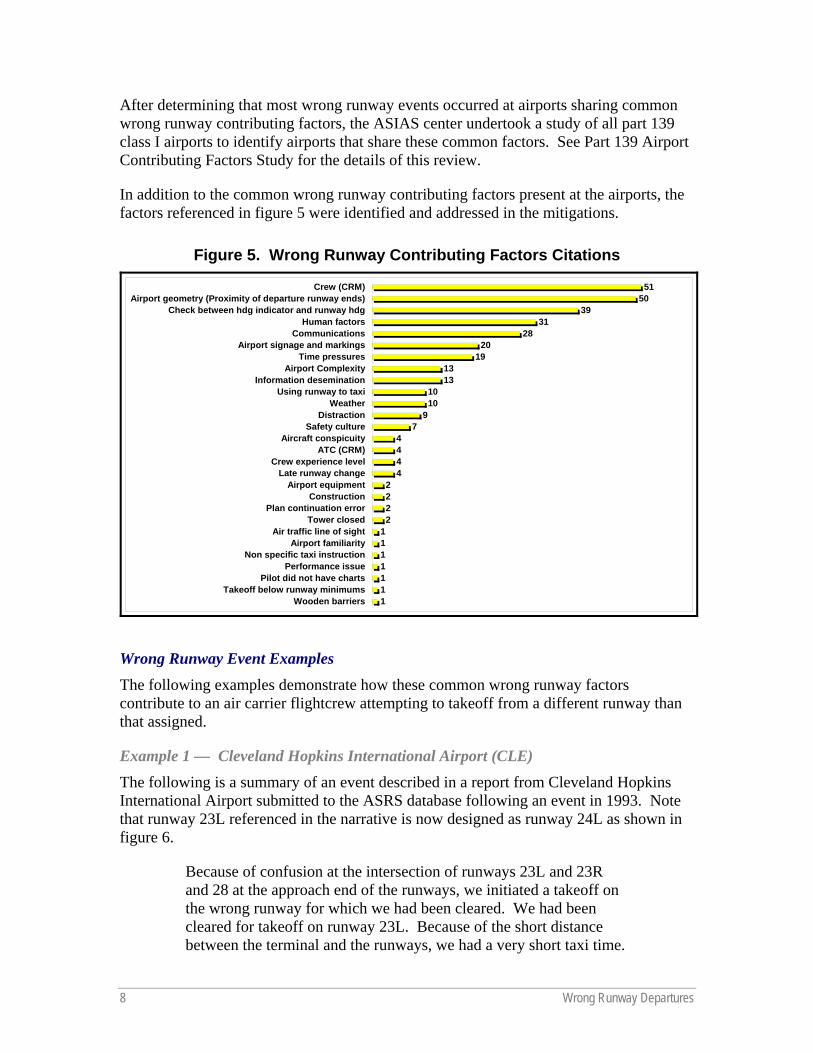
After determining that most wrong runway events occurred at airports sharing common wrong runway contributing factors, the ASIAS center undertook a study of all part 139 class I airports to identify airports that share these common factors. See Part 139 Airport Contributing Factors Study for the details of this review.
In addition to the common wrong runway contributing factors present at the airports, the factors referenced in figure 5 were identified and addressed in the mitigations.
Figure 5. Wrong Runway Contributing Factors Citations
1111111
2222
4444
79
1010
1313
1920
2831
3950
51
Wooden barriersTakeoff below runway minimums
Pilot did not have chartsPerformance issue
Non specific taxi instructionAirport familiarity
Air traffic line of sightTower closed
Plan continuation errorConstruction
Airport equipmentLate runway change
Crew experience levelATC (CRM)
Aircraft conspicuitySafety culture
DistractionWeather
Using runway to taxiInformation desemination
Airport ComplexityTime pressures
Airport signage and markingsCommunications
Human factorsCheck between hdg indicator and runway hdg
Airport geometry (Proximity of departure runway ends)Crew (CRM)
Wrong Runway Event Examples The following examples demonstrate how these common wrong runway factors contribute to an air carrier flightcrew attempting to takeoff from a different runway than that assigned.
Example 1 — Cleveland Hopkins International Airport (CLE) The following is a summary of an event described in a report from Cleveland Hopkins International Airport submitted to the ASRS database following an event in 1993. Note that runway 23L referenced in the narrative is now designed as runway 24L as shown in figure 6.
Because of confusion at the intersection of runways 23L and 23R and 28 at the approach end of the runways, we initiated a takeoff on the wrong runway for which we had been cleared. We had been cleared for takeoff on runway 23L. Because of the short distance between the terminal and the runways, we had a very short taxi time.
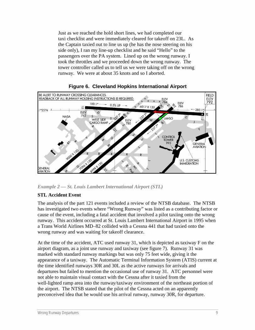
Wrong Runway Departures 9
Just as we reached the hold short lines, we had completed our taxi checklist and were immediately cleared for takeoff on 23L. As the Captain taxied out to line us up (he has the nose steering on his side only), I ran my line-up checklist and he said “Hello” to the passengers over the PA system. Lined up on the wrong runway. I took the throttles and we proceeded down the wrong runway. The tower controller called us to tell us we were taking off on the wrong runway. We were at about 35 knots and so I aborted.
Figure 6. Cleveland Hopkins International Airport
Example 2 — St. Louis Lambert International Airport (STL)
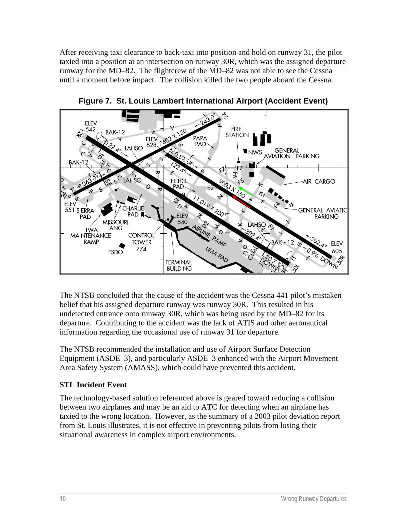
STL Accident Event The analysis of the part 121 events included a review of the NTSB database. The NTSB has investigated two events where “Wrong Runway” was listed as a contributing factor or cause of the event, including a fatal accident that involved a pilot taxiing onto the wrong runway. This accident occurred at St. Louis Lambert International Airport in 1995 when a Trans World Airlines MD–82 collided with a Cessna 441 that had taxied onto the wrong runway and was waiting for takeoff clearance.
At the time of the accident, ATC used runway 31, which is depicted as taxiway F on the airport diagram, as a joint use runway and taxiway (see figure 7). Runway 31 was marked with standard runway markings but was only 75 feet wide, giving it the appearance of a taxiway. The Automatic Terminal Information System (ATIS) current at the time identified runways 30R and 30L as the active runways for arrivals and departures but failed to mention the occasional use of runway 31. ATC personnel were not able to maintain visual contact with the Cessna after it taxied from the well-lighted ramp area into the runway/taxiway environment of the northeast portion of the airport. The NTSB stated that the pilot of the Cessna acted on an apparently preconceived idea that he would use his arrival runway, runway 30R, for departure.
10 Wrong Runway Departures
After receiving taxi clearance to back-taxi into position and hold on runway 31, the pilot taxied into a position at an intersection on runway 30R, which was the assigned departure runway for the MD–82. The flightcrew of the MD–82 was not able to see the Cessna until a moment before impact. The collision killed the two people aboard the Cessna.
Figure 7. St. Louis Lambert International Airport (Accident Event)
The NTSB concluded that the cause of the accident was the Cessna 441 pilot’s mistaken belief that his assigned departure runway was runway 30R. This resulted in his undetected entrance onto runway 30R, which was being used by the MD–82 for its departure. Contributing to the accident was the lack of ATIS and other aeronautical information regarding the occasional use of runway 31 for departure.
The NTSB recommended the installation and use of Airport Surface Detection Equipment (ASDE–3), and particularly ASDE–3 enhanced with the Airport Movement Area Safety System (AMASS), which could have prevented this accident.
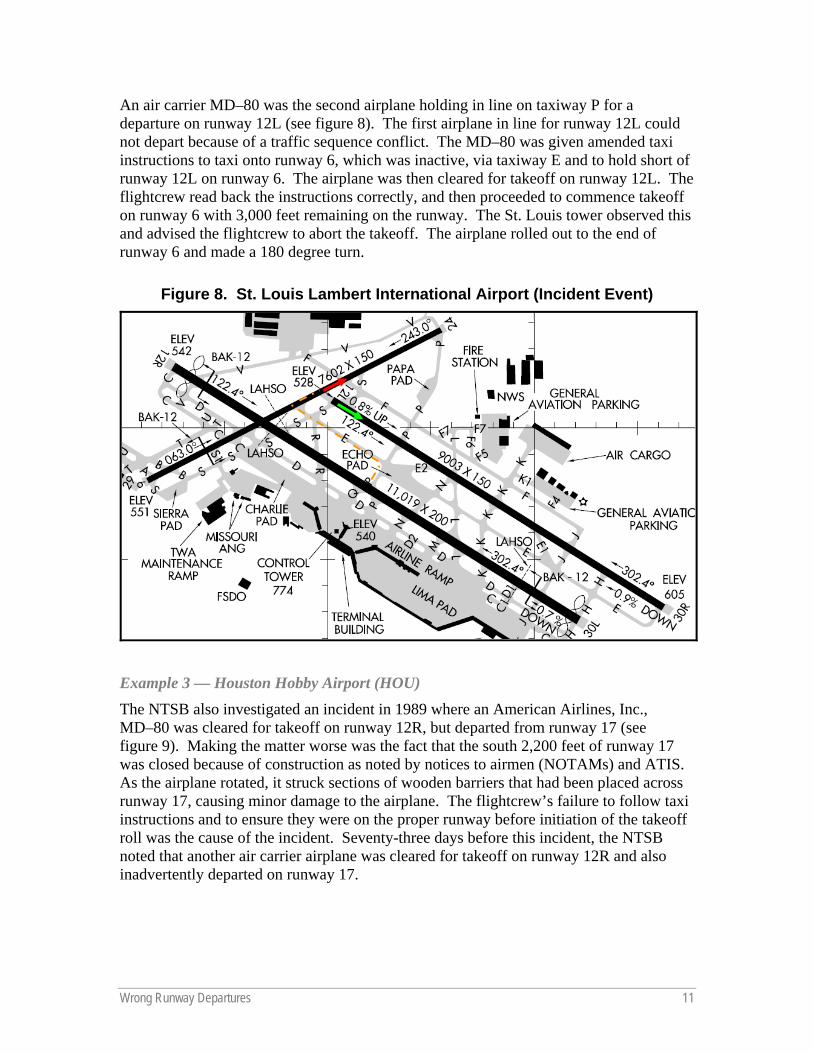
STL Incident Event The technology-based solution referenced above is geared toward reducing a collision between two airplanes and may be an aid to ATC for detecting when an airplane has taxied to the wrong location. However, as the summary of a 2003 pilot deviation report from St. Louis illustrates, it is not effective in preventing pilots from losing their situational awareness in complex airport environments.
Wrong Runway Departures 11
An air carrier MD–80 was the second airplane holding in line on taxiway P for a departure on runway 12L (see figure 8). The first airplane in line for runway 12L could not depart because of a traffic sequence conflict. The MD–80 was given amended taxi instructions to taxi onto runway 6, which was inactive, via taxiway E and to hold short of runway 12L on runway 6. The airplane was then cleared for takeoff on runway 12L. The flightcrew read back the instructions correctly, and then proceeded to commence takeoff on runway 6 with 3,000 feet remaining on the runway. The St. Louis tower observed this and advised the flightcrew to abort the takeoff. The airplane rolled out to the end of runway 6 and made a 180 degree turn.
Figure 8. St. Louis Lambert International Airport (Incident Event)
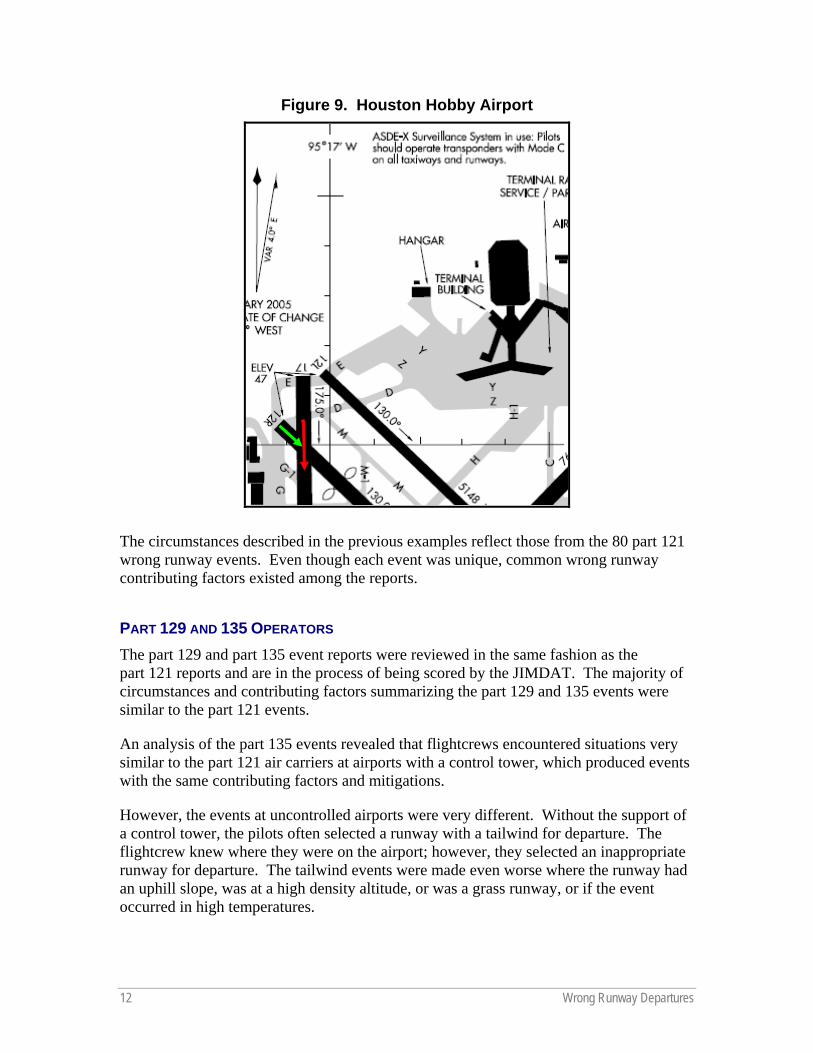
Example 3 — Houston Hobby Airport (HOU) The NTSB also investigated an incident in 1989 where an American Airlines, Inc., MD–80 was cleared for takeoff on runway 12R, but departed from runway 17 (see figure 9). Making the matter worse was the fact that the south 2,200 feet of runway 17 was closed because of construction as noted by notices to airmen (NOTAMs) and ATIS. As the airplane rotated, it struck sections of wooden barriers that had been placed across runway 17, causing minor damage to the airplane. The flightcrew’s failure to follow taxi instructions and to ensure they were on the proper runway before initiation of the takeoff roll was the cause of the incident. Seventy-three days before this incident, the NTSB noted that another air carrier airplane was cleared for takeoff on runway 12R and also inadvertently departed on runway 17.
12 Wrong Runway Departures
Figure 9. Houston Hobby Airport
The circumstances described in the previous examples reflect those from the 80 part 121 wrong runway events. Even though each event was unique, common wrong runway contributing factors existed among the reports.
PART 129 AND 135 OPERATORS The part 129 and part 135 event reports were reviewed in the same fashion as the part 121 reports and are in the process of being scored by the JIMDAT. The majority of circumstances and contributing factors summarizing the part 129 and 135 events were similar to the part 121 events.
An analysis of the part 135 events revealed that flightcrews encountered situations very similar to the part 121 air carriers at airports with a control tower, which produced events with the same contributing factors and mitigations.
However, the events at uncontrolled airports were very different. Without the support of a control tower, the pilots often selected a runway with a tailwind for departure. The flightcrew knew where they were on the airport; however, they selected an inappropriate runway for departure. The tailwind events were made even worse where the runway had an uphill slope, was at a high density altitude, or was a grass runway, or if the event occurred in high temperatures.
Wrong Runway Departures 13
The aeronautical information for the uncontrolled airports was a major factor in these events as well. (See NOTAM Process later in this report.) In one instance, critical information could only be found in the Airport/Facility Directory. The regulations require that pilots become familiar with all available information before each flight; however, charter pilots may not always be issued Airport/Facility Directories by their company.
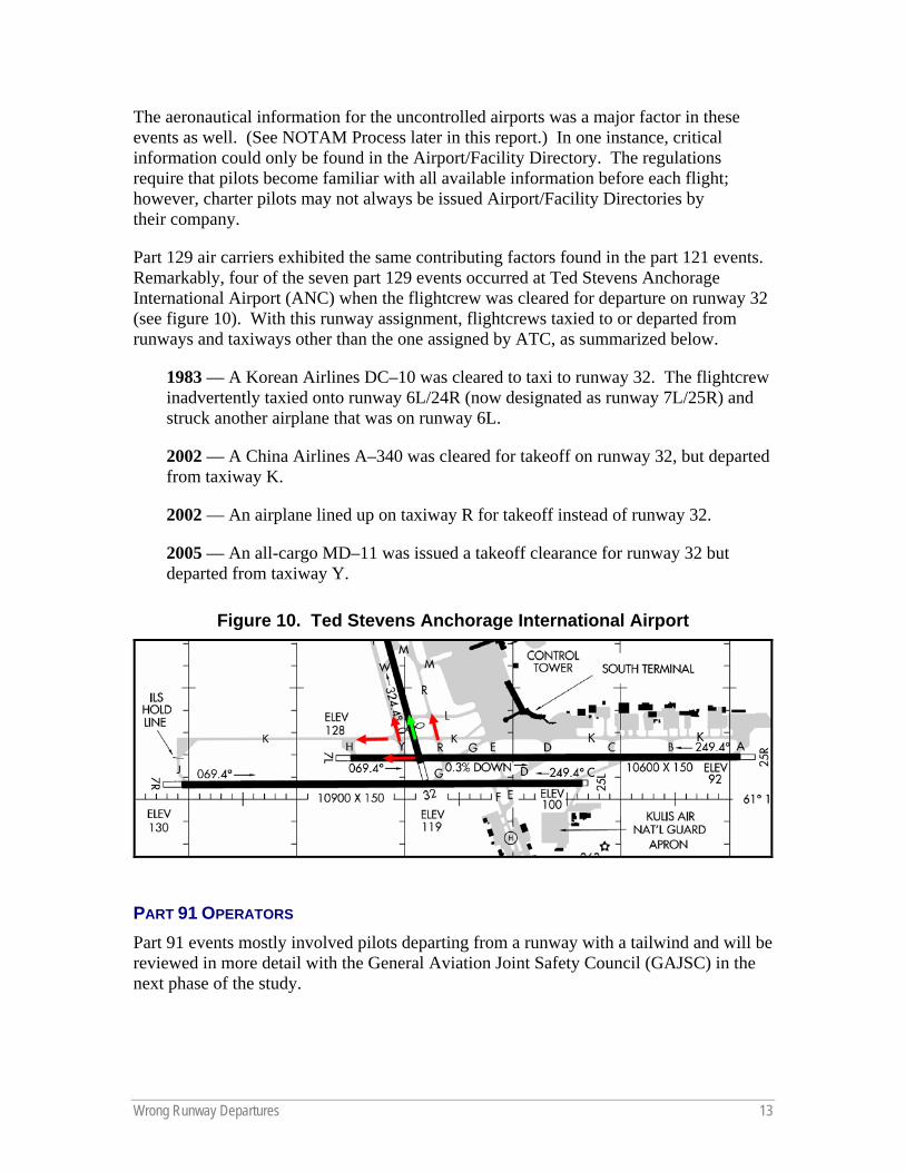
Part 129 air carriers exhibited the same contributing factors found in the part 121 events. Remarkably, four of the seven part 129 events occurred at Ted Stevens Anchorage International Airport (ANC) when the flightcrew was cleared for departure on runway 32 (see figure 10). With this runway assignment, flightcrews taxied to or departed from runways and taxiways other than the one assigned by ATC, as summarized below.
1983 — A Korean Airlines DC–10 was cleared to taxi to runway 32. The flightcrew inadvertently taxied onto runway 6L/24R (now designated as runway 7L/25R) and struck another airplane that was on runway 6L.
2002 — A China Airlines A–340 was cleared for takeoff on runway 32, but departed from taxiway K.
2002 — An airplane lined up on taxiway R for takeoff instead of runway 32.
2005 — An all-cargo MD–11 was issued a takeoff clearance for runway 32 but departed from taxiway Y.
Figure 10. Ted Stevens Anchorage International Airport
PART 91 OPERATORS Part 91 events mostly involved pilots departing from a runway with a tailwind and will be reviewed in more detail with the General Aviation Joint Safety Council (GAJSC) in the next phase of the study.
14 Wrong Runway Departures
MITIGATIONS Proposed Safety Enhancements The following safety enhancements proposed by the SMEs cover technological, procedural, and infrastructure enhancements. These enhancements were then scored by the JIMDAT for their effectiveness as mitigations (see appendix B). Many of the following safety enhancements have already been implemented because of previous safety assessments. The CAST will consider a combination of the effective mitigations already in place and new mitigations based on the enhancements listed below.
Technological Enhancements
Own-Ship Moving Map Display A class 2 electronic flight bag (EFB) with the own-ship position displayed on a surface electronic map for ground operation provides pilots with an invaluable tool — an immediate orientation of the airplane position on the airport surface. It has been identified as the most effective mitigation to prevent wrong runway and runway incursion events. Other benefits of an Own-Ship Moving Map Display include workload reduction by reducing heads-down time by facilitating faster interpretation of airplane position, which allows attention to remain outside the airplane. Ultimately, an Own-Ship Moving Map Display provides supplemental positional awareness by validating visual cues if flightcrew are confused. The enhanced models are described below:
Own-Ship Moving Map Display with Directed Path .......................... 80% risk eliminated This model includes all benefits of the Own-Ship Moving Map Display plus aural warnings to alert the flightcrew members of upcoming runway and taxiway intersections. The system depicts other aircraft on the display and, most importantly, depicts the taxi route the flightcrew is to take to the runway as selected by ATC.
Own-Ship Moving Map Display with Directed Path plus Aural Advisory System/Runway Awareness and Advisory System .............................. 80% risk eliminated This model includes all benefits of the Own-Ship with Directed Path plus an aural advisory system similar to the Runway Awareness and Advisory System.
Own-Ship Moving Map Display – Own-Ship plus Aural Advisory System/Runway Awareness and Advisory System.......................................................... 58% risk eliminated This model includes all benefits of the Own-Ship Moving Map Display plus all the benefits of an aural advisory system similar to the Runway Awareness and Advisory System.
Own-Ship Moving Map Display plus Warning................................... 49% risk eliminated This model includes all benefits of the Own-Ship Moving Map Display, depicts other aircraft on the display, and adds aural warnings to alert the flightcrew members of upcoming runway and taxiway intersections.
Own-Ship Moving Map Display plus Other........................................ 46% risk eliminated This model includes all benefits of the Own-Ship Moving Map Display and depicts other aircraft on the display.
Wrong Runway Departures 15
Own-Ship Moving Map Display – Own-Ship ..................................... 46% risk eliminated This model includes all benefits of the Own-Ship Moving Map Display.
Aural Advisory System/Runway Awareness and Advisory System.................................................................................. 56% risk eliminated An aural advisory system similar to the Runway Awareness and Advisory System provides improved situational awareness by providing timely aural advisories to the flightcrew during taxi, takeoff, final approach, landing, and rollout.
Airport Surface Detection Equipment Model X (ASDE–X) ........... 15% risk eliminated The ASDE–X system provides air traffic controllers with a visual representation of the traffic situation on the airport surface movement area and arrival corridors in the form of aircraft and vehicle position information and flight identifications or call signs. This increased awareness of the situation on the airport surface movement area is essential in reducing runway collision threats and critical category A and B runway incursions. The ASDE–X Safety Logic is an enhancement to the situational awareness provided by the ASDE–X system to air traffic controllers. ASDE–X Safety Logic uses surveillance information from ASDE–X to determine if the current and/or projected positions and movement characteristics of tracked aircraft/vehicles present a potential collision situation. Visual and audible alerts are provided to the controllers, which include critical information about the targets involved, such as identification and surface occupied.
In addition to improving safety through runway incursion prevention, the quality of the ASDE–X data resulting from the fusion of multiple surveillance sources enables decision support for (1) positive correlation of flight plan information with aircraft position on controller displays, (2) seamless surveillance coverage of the airport from arrival through departure, (3) elimination of blind spots and coverage gaps, and (4) highly accurate, high update surveillance enabling situational awareness (even in inclement conditions) and conflict detection and resolution.
CAST has established and completed SE–53 in previous safety assessments.
Airport Surface Detection Equipment Model 3/Airport Movement Area Safety System (ADSE–3/AMASS)............................................ 15% risk eliminated The ASDE–3/AMASS upgrade provides for the technical refresh of the ASDE–3 and AMASS. Selected system components will be replaced or upgraded to extend the service life of these systems through 2023 (ASDE–X End of Service Life (EOSL)), at which point all ASDE systems (ASDE–3/AMASS, ASDE–3X, ASDE–X) will be replaced with a common system. ASDE–3/AMASS is effective because it is currently in use; however, it is being replaced by ASDE–X.
16 Wrong Runway Departures
Procedural Enhancements
Flightcrew Crew Resource Management (CRM) ............................ 46% risk eliminated Flightcrew members must ensure complete pre-taxi/departure briefings are done and include the use of charts and aeronautical information. These briefings should include intended taxi route and any areas or items of concern that may be encountered during the taxi, as well as policies for changes to a briefed plan.
During the taxi, flightcrews should plan to minimize heads-down time, especially while taxiing in congested or confusing areas, and verbally confirm when a flightcrew member is heads-down.
Finally, effective CRM should include a checklist item to ensure the aircraft is aligned with the correct runway, with verification from the airplane’s flight instruments.
CAST has established and completed SE–60 in previous safety assessments.
ATC Clearance Procedure Review.................................................... 32% risk eliminated ATC should review procedure for clearances that specify all runways to be crossed before reaching the departure runway and restrict early takeoff clearances when flightcrews must cross multiple runways before reaching the departure runway.
In addition, the FAA Taxi Into Position and Hold (TIPH) policy should be reviewed for appropriate limits or prohibition depending on airport characteristics. A policy change will have to take into consideration any impact on capacity.
ATC Crew Resource Management.................................................... 22% risk eliminated ATC should adhere to policy and procedures described in “Visually Scanning the Runway” and “Position Determination” from FAA Order 7110.65, Air Traffic Control; use positive control phraseology and clearance read back techniques; and use proper runway crossing phraseology.
These procedures can be trained and tested in ATC simulator scenario-based training.
CAST has established SE–47 in previous safety assessments.
Flightcrew Scenario-based Training ................................................. 21% risk eliminated Enhancements to simulator training during taxi segments need to be made with special emphasis on wrong runway and runway incursion scenarios that promote identification of threat areas and effective CRM techniques demonstrated by the flightcrew.
ATC Scenario-based Training ........................................................... 13% risk eliminated The training would focus on scenarios that promote awareness of the ground environment using ATC simulators. The training would incorporate operations in complex airports, the dangers of runway illusions from gradient, understanding and managing fatigue and time pressures, Taxi Into Position and Hold (TIPH) and parallel departures with mixed experience operations scenarios.
Wrong Runway Departures 17
Aeronautical Information Dissemination ........................................... 5% risk eliminated The NOTAM distribution method (see NOTAM Process later in this report, and appendix C) highlights the urgent need for a replacement system to help ensure critical safety information reaches the pilot and other system users. The FAA has a major initiative underway to address the collection and dissemination of critical aeronautical information.
Aircraft External Lighting ................................................................... 3% risk eliminated The use of exterior airplane lights makes airplanes more visible during takeoff and when cleared on a runway. For takeoff, many part 121 air carriers turn on all exterior lights when clearance is received or when commencing takeoff roll at an airport without an operating tower to be as conspicuous as possible.
Infrastructure Enhancements
Taxiway and Runway Configuration ................................................ 45% risk eliminated Airports that have areas with multiple runway thresholds in close proximity could be redesigned to move the thresholds and eliminate the threat of a wrong runway departure. In addition, future airports may consider designs without these areas.
Runway Safety Action Team (RSAT) Evaluations .......................... 30% risk eliminated A Runway Safety Action Team is established at either the regional or local level to develop a Runway Safety Action Plan for a specific airport. The Runway Safety Action Team’s primary purpose is to address existing runway safety problems and issues. A secondary purpose is to identify and address potential runway safety issues. Currently, the main focus of RSATs is runway incursion areas; however, it could be expanded to include assessing the threat of wrong runway events.
Enhanced Surface Marking and Lighting ........................................ 29% risk eliminated In areas that have been identified with a higher threat of having a wrong runway event, runway status lights (RSLs), such as those in Cleveland, should be installed, as well as the Final Approach Runway Occupancy Signal (FAROS) system.
JIMDAT Scoring
Calculation of a Safety Enhancement’s JIMDAT Score
The JIMDAT spreadsheet tool determines the severity eliminated by each specific proposed safety enhancement by summing the products of effectiveness, incident/accident severity, future risk factor, and implementation for each incident/accident in the accident set. The JIMDAT score is then calculated by dividing the severity eliminated by the total severity of the incident/accident set. The JIMDAT score represents the portion of the risk associated with the incident/accident set that would have been eliminated by the particular enhancement acting on its own. The JIMDAT score is often expressed as a percentage by multiplying by 100. (See appendix B to this report.)
18 Wrong Runway Departures
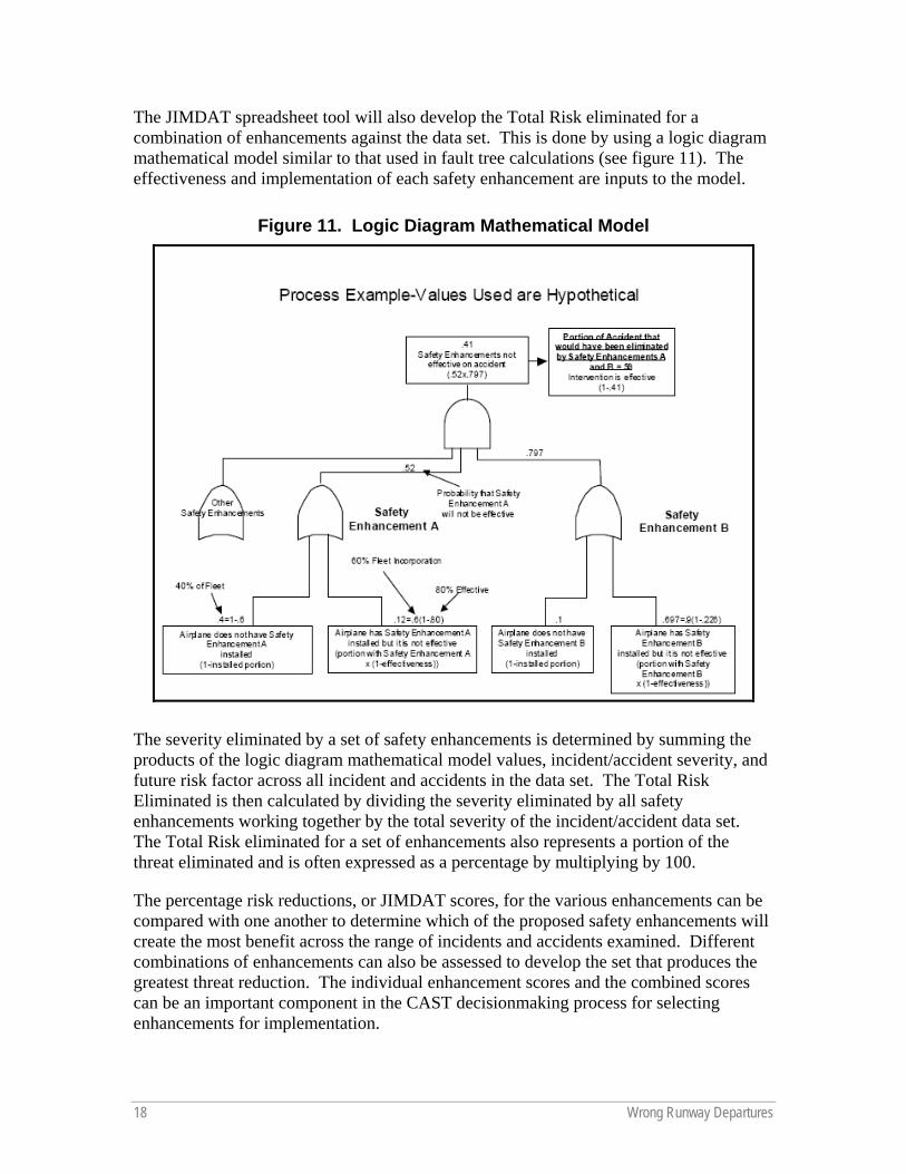
The JIMDAT spreadsheet tool will also develop the Total Risk eliminated for a combination of enhancements against the data set. This is done by using a logic diagram mathematical model similar to that used in fault tree calculations (see figure 11). The effectiveness and implementation of each safety enhancement are inputs to the model.
Figure 11. Logic Diagram Mathematical Model
The severity eliminated by a set of safety enhancements is determined by summing the products of the logic diagram mathematical model values, incident/accident severity, and future risk factor across all incident and accidents in the data set. The Total Risk Eliminated is then calculated by dividing the severity eliminated by all safety enhancements working together by the total severity of the incident/accident data set. The Total Risk eliminated for a set of enhancements also represents a portion of the threat eliminated and is often expressed as a percentage by multiplying by 100.
The percentage risk reductions, or JIMDAT scores, for the various enhancements can be compared with one another to determine which of the proposed safety enhancements will create the most benefit across the range of incidents and accidents examined. Different combinations of enhancements can also be assessed to develop the set that produces the greatest threat reduction. The individual enhancement scores and the combined scores can be an important component in the CAST decisionmaking process for selecting enhancements for implementation.
Wrong Runway Departures 19
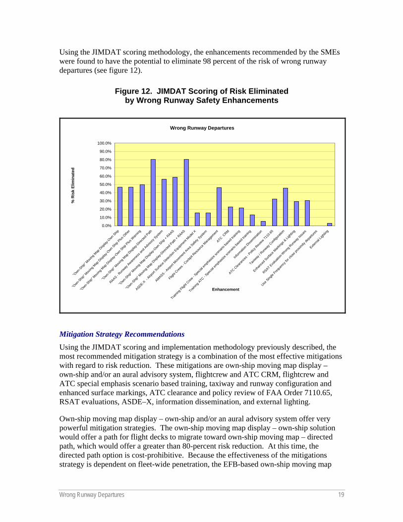
Using the JIMDAT scoring methodology, the enhancements recommended by the SMEs were found to have the potential to eliminate 98 percent of the risk of wrong runway departures (see figure 12).
Figure 12. JIMDAT Scoring of Risk Eliminated by Wrong Runway Safety Enhancements
Wrong Runway Departures
0.0%
10.0%
20.0%
30.0%
40.0%
50.0%
60.0%
70.0%
80.0%
90.0%
100.0%
"Own-S
hip" M
oving
Map
Disp
lay-O
wn Ship
"Own-S
hip" M
oving
Map
Disp
lay-O
wn Ship
Plus
Othe
r
"Own-S
hip" M
oving
Map
Disp
lay-O
wn Ship
Plus
Warn
ing
"Own-S
hip" M
oving
Map
Disp
lay-D
irecte
d Path
RAAS - Run
way Aware
ness
and A
dviso
ry Sys
tem
"Own-S
hip" M
oving
Map
Disp
lay-O
wn Ship
+ RAAS
"Own-S
hip" M
oving
Map
Disp
lay-D
irecte
d Path
+ RAAS
ASDE-X -
Airport
Surf
ace D
etecti
on E
quipm
ent M
odel
X
AMASS - Airp
ort M
ovem
ent A
rea Safe
ty Sys
tem
Flight
Crews -
Coc
kpit R
esou
rce M
anag
emen
t
ATC CRM
Trainin
g Flig
ht Crew
- Spe
cial e
mphas
ize sc
enari
o bas
ed tra
ining
Trainin
g ATC - S
pecia
l emph
asize
scen
ario b
ased
traini
ng
Inform
ation
Diss
emina
tion
ATC Clea
rance
s - P
olicy
Rev
iew 71
10.65
Taxiway
/ Run
way C
onfig
uratio
n
Enhan
ced S
urfac
e Mark
ings &
Ligh
ting
RSAT Eva
luatio
n-Wron
g Run
way Is
sues
Use Sing
le Freq
uenc
y for
close
prox
imity
depa
rtures
Externa
l Ligh
ting
Enhancement
% R
isk
Elim
inat
ed
Mitigation Strategy Recommendations Using the JIMDAT scoring and implementation methodology previously described, the most recommended mitigation strategy is a combination of the most effective mitigations with regard to risk reduction. These mitigations are own-ship moving map display – own-ship and/or an aural advisory system, flightcrew and ATC CRM, flightcrew and ATC special emphasis scenario based training, taxiway and runway configuration and enhanced surface markings, ATC clearance and policy review of FAA Order 7110.65, RSAT evaluations, ASDE–X, information dissemination, and external lighting.
Own-ship moving map display – own-ship and/or an aural advisory system offer very powerful mitigation strategies. The own-ship moving map display – own-ship solution would offer a path for flight decks to migrate toward own-ship moving map – directed path, which would offer a greater than 80-percent risk reduction. At this time, the directed path option is cost-prohibitive. Because the effectiveness of the mitigations strategy is dependent on fleet-wide penetration, the EFB-based own-ship moving map
20 Wrong Runway Departures
display – own-ship solution would help provide effective mitigations for aircraft with limited space for additional standalone equipment in the flight deck. This solution also would offer risk reductions for runway incursions and other safety initiatives.
A combination of own-ship moving map display – own-ship and an aural advisory system would offer a combined risk elimination of nearly 60 percent.
Flightcrew member and ATC CRM combined offer a 57-percent risk reduction. The CAST already has completed SE–60, pertaining to flightcrew CRM and has begun work on SE–47 for ATC CRM. Therefore, no new action is proposed for these mitigation strategies; however, the existing work should be updated to incorporate the wrong runway departure information for future flightcrew and ATC CRM training.
The wrong runway special emphasis scenario-based training offers a 21-percent risk reduction. In addition, ATC wrong runway special emphasis scenario-based training has a 13-percent risk reduction. The combined training mitigation would use the lessons learned from this report to ensure both flightcrew members and ATC personnel are aware of the risks and trained appropriately.
The taxiway and runway configuration changes coupled with enhanced surface markings offer significant risk elimination, 45% and 29% respectively. The high cost of these projects will require integration of the mitigation strategies into existing airport improvement projects.
A review of the ATC Clearances and Policy established in FAA Order 7110.65 would offer a 32-percent risk reduction. The mitigation example described in the next section developed by Cleveland Hopkins International Airport offers a powerful example of the benefit of reviewing these procedures to reduce the risk of a wrong runway departure.
RSAT evaluations are already scheduled at 60 percent of the airports that have experienced wrong runway departure issues and offer a 32-percent risk reduction. The focus of these evaluations should be expanded from runway incursions to include wrong runway departures.
The installation of ASDE–X equipment has already been established as a CAST safety enhancement for certain airports as SE–53. This study has found that it will provide a 15-percent risk reduction for wrong runway airports. Twelve of the 38 wrong runway airports have ASDE–X, or are on the implementation schedule. This existing and future work will continue to reduce the risk of wrong runway departures.
The FAA ATO is in the process of redesigning aeronautical information products and the notice to airmen system. This work is expected to reduce the risk of wrong runway departures by 5 percent. The wrong runway working group is working with ATO to establish the best strategy to incorporate wrong runway departure finding into this process.
Wrong Runway Departures 21
Finally, a mitigation strategy has been established to explore the feasibility of enhancing airplane external lighting to provide additional conspicuity from behind and is expected to offer a 3-percent wrong runway departure risk reduction.
While each of these safety enhancements are effective in reducing the risk of wrong runway departures, the discussion below offers an example of the effectiveness of multiple strategies to address the issues identified in this study.
Cleveland Hopkins International Airport Mitigation Example The study of wrong runway airplane departures highlighted the Cleveland Hopkins International Airport. Twenty-four percent of the part 121 events occurred in Cleveland, which exhibited many of the contributing factors found in the incident review. The contributing factors found included a short taxi distance from the terminal to the runway 28 and 24L departure ends, multiple runway departure ends in close proximity to one another, the use of a runway as a taxiway, complex airport layout, one taxiway leading to multiple runways, and areas where multiple runways and/or taxiways converge.
This airport is unique also because the trend in reported events at Cleveland has decreased dramatically. To determine the mitigations implemented at Cleveland to reduce the threat of wrong runway departures, the FAA, working with the Air Line Pilots Association, International (ALPA), interviewed several airport administration personnel, FAA personnel, and pilots with knowledge of the operating environment during the 1990s. The discussions revealed that during the early 1990s, Cleveland airport began to experience an increase in wrong runway departures. As the incident reports began to accumulate, ALPA, Cleveland airport administration, and the FAA began a cooperative effort and used a combination of safety enhancements to improve the airport signage and markings, implement new air traffic and flightcrew procedures, and obtain funding to redesign the airport layout.
The first changes to the Cleveland airport design and construction to occur during the last 20 years were changes to signage resulting from changes to FAA standards following a high profile collision at Detroit Metro Airport between two Northwest Airlines airplanes. The primary change at Cleveland was the addition of runway location signs between 1991 and 1993.
The addition of signage did not, however, address some of the most significant problems encountered at Cleveland: pilots inadvertently departing from incorrect runways or failing to hold short of active runways. In particular, there was a tendency for pilots taxiing to runway 24L to either inadvertently use runway 28 and/or fail to hold short of runway 24L. A number of efforts were made to address this situation.
First, taxiway T was removed. The taxiway used to extend from the terminal area to roughly the intersection of runways 24L/6R and 10/28, between current taxiways W and U. (Taxiway W did not exist at the time.) (See figure 13.) Ground control used taxiway T to stage airplanes for departure on runway 24L. This was problematic because
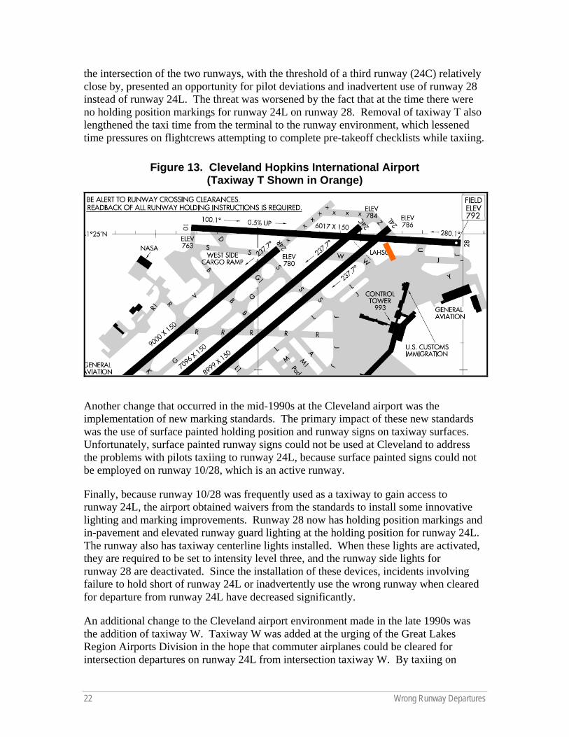
22 Wrong Runway Departures
the intersection of the two runways, with the threshold of a third runway (24C) relatively close by, presented an opportunity for pilot deviations and inadvertent use of runway 28 instead of runway 24L. The threat was worsened by the fact that at the time there were no holding position markings for runway 24L on runway 28. Removal of taxiway T also lengthened the taxi time from the terminal to the runway environment, which lessened time pressures on flightcrews attempting to complete pre-takeoff checklists while taxiing.
Figure 13. Cleveland Hopkins International Airport (Taxiway T Shown in Orange)
Another change that occurred in the mid-1990s at the Cleveland airport was the implementation of new marking standards. The primary impact of these new standards was the use of surface painted holding position and runway signs on taxiway surfaces. Unfortunately, surface painted runway signs could not be used at Cleveland to address the problems with pilots taxiing to runway 24L, because surface painted signs could not be employed on runway 10/28, which is an active runway.
Finally, because runway 10/28 was frequently used as a taxiway to gain access to runway 24L, the airport obtained waivers from the standards to install some innovative lighting and marking improvements. Runway 28 now has holding position markings and in-pavement and elevated runway guard lighting at the holding position for runway 24L. The runway also has taxiway centerline lights installed. When these lights are activated, they are required to be set to intensity level three, and the runway side lights for runway 28 are deactivated. Since the installation of these devices, incidents involving failure to hold short of runway 24L or inadvertently use the wrong runway when cleared for departure from runway 24L have decreased significantly.
An additional change to the Cleveland airport environment made in the late 1990s was the addition of taxiway W. Taxiway W was added at the urging of the Great Lakes Region Airports Division in the hope that commuter airplanes could be cleared for intersection departures on runway 24L from intersection taxiway W. By taxiing on
Wrong Runway Departures 23
taxiway W to the intersection, the airplane would be kept from inadvertent use of runway 28. This initiative has had only limited success because of pilots’ hesitation to perform intersection departures.
The most recent changes to the airport layout have been in connection with the construction of runway 6L/24R. Runway construction began in 2001 as part of a three-phase Operational Evolution Plan (OEP) intended to provide greater separation between parallel runways to permit simultaneous instrument operations. FAA funding was designated for this project to reduce the threat of a collision or accident. Phase I included initial construction of the northern portion of the new runway. At that time, the northern runway threshold was contiguous with the northern end of the pavement, and the runway intersected existing crosswind runway 10/28. In phase II, runway 6L/24R was extended to the south to its current extent, and the threshold was moved south to its current location. The pavement to the north of the threshold is currently still paved. The runway surface itself no longer intersects runway 10/28, but the pavement that is not yet removed does. The plan is to remove the pavement to mitigate the threat of runway incursions and wrong runway events, but this has not occurred yet because of the lack of funding, despite pressure from the FAA and ALPA. Phase III will involve the extension of runway 6R/24L to the south, with a displacement of its northern threshold, similar to runway 6L/24R’s. This will uncouple runway 24L from runway 28 and effectively eliminate the area of greatest threat for departures on the incorrect runway and runway incursions. The use of the center runway, 6C/24C, will eventually be discontinued, and the runway will be converted to a taxiway.
Construction of runway 6L/24R and supporting taxiways was substantial and involved moving a road and a portion of the NASA facility on the west side of the field. During the addition of runway 6L/24R, changes also were made to taxiway K1, which used to be runway 18/36. Taxiway K1 used to extend to the intersection of taxiways A, L, Q, and R. The confluence of the multiple taxiways was extremely confusing, and posed a threat of airplanes turning onto the wrong taxiway, with potential for a runway incursion.
Following the opening of runway 6L/24R, problems arose involving airplanes crossing runways 6R/24L and 6C/24C while taxiing to and from the new runway. The presence of two parallel runways so close to each other presented a possibility for confusion. For example, a flightcrew cleared to cross one runway might accidentally cross both runways. After incursions or near incursions and complaints from ALPA, and at the urging of the Great Lakes Region Airports Division, holding position markings were added on the taxiways between each of the runways. Before this, there were no such markings, possibly because it was believed there was inadequate space to hold between the two runways.
Changes also were made to ATC and flightcrew procedures. ATC conducted tower controller briefings following each airplane departing on the wrong runway. From these briefings, two basic policies were implemented. First, airplanes departing runway 24L or runway 24C are issued a TIPH clearance. Secondly, the ATC tower controller visually verifies the airplane is on the correct runway before issuing a takeoff clearance.
24 Wrong Runway Departures
Likewise, the pilot community began to adjust their procedures to reduce the threat of a departure on the wrong runway. A part 121 air carrier added the area around runways 24L and 28 at Cleveland to the Jeppesen 10–7 chart as an area of concern. This chart pointed out the hazards at the airport based on the event reports that had been reviewed. The air carrier also implemented a heading check for departures from runway 24L. Finally, the air carrier eliminated its taxi checklist to maximize the heads-up time during the taxi for both the pilot taxiing and the pilot monitoring the taxi. At this air carrier, after push back from the gate, the engines are started and the after-start checklist is completed. Part of the after-start checklist involves completely configuring the airplane for departure and is completed before the taxi begins.
The cooperative effort and use of a combination of safety enhancements to improve the overall safety proved to be successful in Cleveland and can be a useful method for other airport communities to adopt.
Wrong Runway Departures 25
NOTAM PROCESS
Part of the wrong runway study included a review of how notices to airman (NOTAMs) are issued. At the time of the Comair accident, updated taxiway information for Lexington was available via NOTAM.3 However, the NTSB stated that Comair’s system was not set up to receive local NOTAMs and it was instructed to contact the local flight service station (FSS) for local NOTAMs.4 The NTSB also noted that the ATIS only informed the flightcrew of “construction on the air carrier ramp.” Aero-News.net noted that the NOTAM did not explicitly direct the pilots on how to get to the correct runway with part of the taxiway closed. Aero-News.net also noted that the NOTAM was revised after the crash to explicitly direct pilots on how to taxi to runway 22. 5
There are a number of different NOTAMs, issued depending on the information to be conveyed, as follows:
• NOTAM D — NOTAM Ds are widely disseminated by means of telecommunications and concern the establishment, condition, or change in any aeronautical facility, service, procedure, or hazard, the timely knowledge of which is essential to personnel concerned with flight operations.
• NOTAM L — NOTAM Ls are locally disseminated and contain information regarding airport and taxiway construction and certain airport lighting directly related to surface movement guidance, and control or contain information concerning navigation aids, lighting, and runways expected to be in effect for less than 1 hour.
• FDC (Flight Data Center) NOTAM — FDC NOTAMs contain regulatory information such as changes to instrument flight rules charts, procedures, and airspace use.
The need for a NOTAM can be generated by a number of different entities, including airport management or the facility responsible for the lighting, navigation aid, communications, or services in the case of NOTAMs D and L and the FAA, the air route traffic control center, technical operations personnel, and other authorized personnel in the case of FDC NOTAMs. (See figure C–1 in appendix C for further information on types of NOTAMs and who initiates the action.) The office generating the need for a NOTAM will pass that information to the responsible FSS or the U.S. NOTAM office. Generally, NOTAMs D and L are issued by an FSS, and FDC NOTAMs are issued by the U.S. NOTAM office. Figure C–2 in appendix C provides a flowchart detailing what it appears the steps are in the NOTAM process. However, it should be noted that it is not clear whether these are the exact steps; FAA guidance material is more detailed in some areas than others and required some interpretation. The biggest difference between a NOTAM D and a NOTAM L is in the distribution process. NOTAM Ds are distributed 3 NOTAM L No. L0808 (airport authority No. A-1682), "T/W Alpha North of R/W 8-26 Closed UFN"; issued August 2, 2006, at 2:05 p.m. 4 National Transportation Safety Board, Group Chairman’s Factual Report, Operation Factors, DCA06MA064, December 17, 2006. 5 http://aero-news.net, “Was Lexington ATIS, NOTAM too Vague,” September 25, 2006.
26 Wrong Runway Departures
electronically via the National Airspace Data Interchange Network6 (NADIN) to the Weather Message Switching Center Replacement7 (WMSCR) and then to all locations receiving the affected location’s tie-in FSS weather. A NOTAM L, on the other hand, is disseminated by the local FSS to all ATC facilities affected, the Air Route Traffic Control Center responsible for forwarding NOTAMs to affected locations, and any local aviation companies, airline operations offices, and other interested users. (See figure C–3 in appendix C for a flowchart depicting the issuance and distribution of NOTAMs D and L. Also provided for reference is figure C–4 in appendix C, which depicts the issuance and distribution of FDC NOTAMs). It appears, therefore, that if an entity is not part of the FSS’s NOTAM L distribution, the only way that entity will receive a NOTAM L is to request all local NOTAMs regarding that facility from the FSS.
On January 9, 2007, the FAA issued CertAlert 07–01 on the Need for Better Dissemination of Runway/Taxiway Closure Information and Construction on Airports. Note that this CertAlert was not issued because of the Lexington accident. In this CertAlert, the FAA encouraged the dissemination, to the air carriers and fixed-base operators on an airport, of better and more detailed information on runway/taxiway closures and construction taking place on airports and noted that the NOTAM system may be inadequate. In response to this CertAlert, ALPA stated the following:
The Certalert is welcome recognition that the current NOTAM system, developed for the teletype era, is inadequate and must evolve with the times. The FAA’s Certalert falls short, however, by recommending that only carriers and fixed-base operators receive information about construction and closures on an airport. Of all parties, pilots have the greatest need for timely and accurate information on these issues. The information must be available from anywhere in the system, so that pilots will have the opportunity to incorporate it into predeparture flight planning.8
The FAA has a significant effort underway to redesign the Aeronautical Information Management (AIM) process that follows the international Aeronautical Information Exchange Model (AIXM) of adoption and implementation.
6 A data communication system server used for data interchange within the United States, and between the United States and other nations to communicate flight plans for commercial and general aviation, weather, and advisory notices to pilots. 7 A network that serves as the FAA gateway for the receipt and distribution of weather data and NOTAMs within the National Airspace System. 8 www.alpa.org, “Pilots Need Aircraft Position Information in the Cockpit,” January 17, 2007, Capt. Terry McVenes, Executive Air Safety Chairman, Air Line Pilots Association, International.
Wrong Runway Departures 27
PART 139 AIRPORT CONTRIBUTING FACTORS STUDY
SCOPE OF THE STUDY Airports certified by the FAA to accommodate large scheduled and nonscheduled air carrier airplanes as well as scheduled small air carrier airplanes are classified as part 139 class I airports. It was imperative not only to study airports where wrong runway departure events occurred, but to review all airports to proactively identify and mitigate the physical characteristics of wrong runway event threat areas. Based on these physical factors, a matrix was created to record each element present at all 355 class I airports (see appendix D). The airport received an “*” for each wrong runway event threat item described below.
The data was loaded into the ASIAS Event Monitoring System – Airports (EMS–Airports). The system enables users to visually compare the event trend around a selected airport with the average trend for all airports of the same class.
Note: It is important to note that risk reduction strategies that may be underway at individual airports were not considered in the scoring. For example, the Cleveland airport received an “*” for the area with multiple runway thresholds in close proximity even though there is a plan to decouple the runways, as discussed in the Cleveland Hopkins International Airport mitigation example.
WRONG RUNWAY EVENT THREATS
Short Taxi Distance A short distance between the terminal and the runway requires pilots to complete the same number of checklist items in a shorter timeframe and can lead to flightcrew rushing to complete their checklists or expedite their departure.
Airport Complexity The complexity of an airport layout includes factors such as a high traffic volume, requiring an airplane to cross multiple runways to reach the departure runway, and complicated taxi instructions that involve the use of several taxiways.
One Taxiway Leading to Multiple Runway Thresholds
These areas present an opportunity for flightcrews to taxi the airplane onto the wrong runway. This is especially true when the airplane has to cross one or more runways on the same taxiway.
Close Proximity of Multiple Runway Thresholds Many wrong runway events took place in areas with multiple runway thresholds in close proximity. In some cases, multiple runway ends are in the same location.
28 Wrong Runway Departures
More Than Two Taxiways Intersecting in One Area These areas often confuse pilots and present the opportunity to turn in an incorrect direction.
Short Runway (Less Than 5,000 feet) Wrong runway departures typically result in the airplane taking off without conflict because there is sufficient runway available. Part 139 class I airports with runways less then 5,000 feet located in close proximity to longer runways were identified to point out potential situations where the runway is too short for a large air carrier jet to safely takeoff.
Joint Use Runway/Taxiway In the wrong runway events, identified pilots had a tendency to depart on the runway that they were taxiing on instead of turning onto the correct runway when a takeoff clearance was issued.
Single Runway Airports with a single runway layout present the opportunity for an airplane to taking off in the wrong direction, especially when intersection departures are made.
A preliminary review of the 355 part 139 class I airports shows that even though wrong runway events have not occurred at each location, many of the airports have similar physical characteristics that were found to be contributing factors (see figure 14).
Figure 14. Percentage of Part 139 Airports With Associated Wrong Runway Threat Areas
Short Taxi Distance26%
Airport Complexity7%
One Txwy to Multiple Rwys17%
Close Prox. of Mult. Rwy Thresholds
16%
More than two Txwys Intersecting in one Area
5%
Short Runway (< 5000 feet)5%
Joint Use Runway/Taxiway14%
Single Runway10%
Wrong Runway Departures 29
CONCLUSIONS AND RECOMMENDATIONS
Wrong runway departure events continue to occur even after the Lexington accident. Only 60 days after the Lexington accident, an air carrier flightcrew departed from the wrong runway at Seattle Tacoma International Airport. To effectively prevent more of these events, the recommended strategy is implementation of a combination of the most effective JIMDAT mitigations with regard to risk reduction. These mitigations are own-ship moving map display – own-ship and/or an aural advisory system, flightcrew and ATC CRM, flightcrew and ATC special emphasis scenario based training, taxiway and runway configuration and enhanced surface markings, ATC clearance and policy, RSAT evaluations, ASDE–X, information dissemination, and external lighting.
Own-ship moving map display – own-ship and/or an aural advisory system combine to form a very powerful mitigation strategy. A combination of own-ship moving map display – own-ship and an aural advisory system would produce a combined risk elimination of nearly 60 percent while offering a path for flight decks to migrate toward own-ship moving map – directed path, which has a risk reduction greater than 80-percent. This solution also would offer risk reductions for runway incursions and other safety initiatives.
Flightcrew member and ATC CRM combined offer a 57-percent risk reduction. The CAST already has established initiatives for these mitigations; therefore, the existing work should be updated to incorporate the wrong runway departure information for future flightcrew and ATC CRM training.
RSAT evaluations are already scheduled at 60 percent of the airports that have experienced wrong runway departure issues. At a cost of $1,500 and offering a 32-percent risk reduction, the focus of these evaluations should be expanded from runway incursions to include wrong runway departures.
A review of the ATC clearances and policies offer a 32-percent risk reduction. The mitigation used by Cleveland Hopkins International Airport offers a powerful example of the benefit of reviewing these procedures to reduce the risk of a wrong runway departure.
The wrong runway special emphasis scenario-based training for flightcrew offers a 21-percent risk reduction. In addition, ATC wrong runway special emphasis scenario-based training would produce a 13-percent risk reduction. The combined effort would use the lessons learned from this report to ensure both flightcrew members and ATC personnel are aware of the risks and trained appropriately.
The installation of ASDE–X equipment has already been established as a CAST safety enhancement for certain airports. This study has found that it will provide a 15-percent risk reduction for wrong runway airports. Twelve of the 38 wrong runway airports have ASDE–X, or are on the implementation schedule. This existing and future work will continue to reduce the risk of wrong runway departures.
30 Wrong Runway Departures
The taxiway and runway configuration changes coupled with enhanced surface markings offer significant risk elimination. The high cost of these projects will require integration of the mitigation strategies into existing airport improvement projects.
The FAA ATO has taken action to encourage the better dissemination of airport construction information with the AIM process that follows the international AIXM of adoption and implementation. This work is expected to reduce the risk of wrong runway departures by 5 percent.
The feasibility of enhancing airplane external lighting to provide additional conspicuity from behind should be explored and is expected to offer a 3-percent wrong runway departure risk reduction.
Finally, the review of the NOTAM process highlighted that the FAA guidance and documentation that describes the NOTAM process is inconsistent and unclear. In addition, NOTAMs L are only disseminated as determined by the local FSS issuing them and have to be specifically requested to be received. While the FAA has taken action to encourage the better dissemination of airport construction information, the AIM process that follows the international AIXM of adoption and implementation will have an additional positive impact in reducing these events.
Wrong Runway Departures A–1
APPENDIX A — SUBJECT MATTER EXPERT PANEL
Executive Steering Committee Anthony Ferrante FAA, AVS Air Traffic Safety Oversight Jay Pardee FAA, AVS Safety Analysis Unit Paul Russell Boeing Commercial Airplane Group, Airplane Safety
Working Group Co-Chair Vivek Sood FAA, Aviation Safety Information Analysis and Sharing Corey Stephens Air Line Pilots Association, Engineering and Accident
Investigation
Subject Matter Expert Panel Darryel Adams FAA, AAS Airport Safety and Operations AJ Bayuk Air Line Pilots Association, Air Safety Volunteer David Bennett FAA, ARP Office Airport Safety and Standards Chad Brewer FAA, AOV Safety Management Division Steve Bush Regional Airline Association Rick Clarke FAA, AFS Air Carrier Operations Nathan Enders FAA, AOV Air Traffic Oversight Service Jim Fee Phaneuf Associates Incorporated, Aviation Safety Analyst Paul Friedman FAA, AAS Airport Engineering Division Jeff Gorney FAA, AAI Recommendation Branch Pierre Huggins Air Line Pilots Association, Engineering and Air Safety George Legarreta FAA, AAS Airport Engineering Division Joe Mantello FAA, AOV Air Traffic Operations Oversight Division Robert Noges Boeing Commercial Airplane Group, Aviation Safety Dave Patterson Data Union, Aviation Safety Information Analysis and Sharing Greg Peoples FAA, ATO Terminal Services Bill Phaneuf Air Line Pilots Association, Engineering and Air Safety Henry Reed Boeing Commercial Airplane Group, Safety Analyst Mitchell Serber Air Line Pilots Association, Air Safety Volunteer Don Slaughter Data Union, Aviation Safety Information Analysis and Sharing Jared Smith Regional Airline Association Frank Stadmeyer FAA, Aircraft Certification Service John Timmerman FAA, ATO System Operations Larry Wippman Phaneuf Associates Incorporated, Aviation Safety Information
Analysis and Sharing
Appendix A — Subject Matter Expert Panel
A–2 Wrong Runway Departures
Matt Wise Regional Airline Association Jerry Wright Air Line Pilots Association, Engineering and Air Safety James White FAA, ARP Office Airport Safety and Standards
Wrong Runway Departures B–1
APPENDIX B — JIMDAT MITIGATION SCORING TABLE
Own-
Ship
Mov
ing
Map
Disp
lay-O
wn
Ship
Ow
n-Sh
ip M
ovin
g Ma
p Di
splay
-Own
Sh
ip P
lus O
ther
Ow
n-Sh
ip M
ovin
g Ma
p Di
splay
-Own
Sh
ip P
lus W
arni
ng
Own-
Ship
Mov
ing
Map
Disp
lay-
Dire
cted
Pat
h RA
AS -
Runw
ay A
ware
ness
and
Advis
ory S
yste
m
Own-
Ship
Mov
ing
Map
Disp
lay-O
wn
Ship
+ RA
AS
Own-
Ship
Mov
ing
Map
Disp
lay-
Dire
cted
Pat
h + R
AAS
ASDE
-X -
Airp
ort S
urfa
ce D
etec
tion
Equi
pmen
t Mod
el X
AMAS
S - A
irpor
t Mov
emen
t Are
a Sa
fety
Sys
tem
Fl
ight
Cre
ws -
Cock
pit R
esou
rce
Mana
gem
ent
ATC
CRM
Train
ing
Flig
ht C
rew
- Spe
cial
emph
asize
scen
ario
bas
ed tr
ainin
g Tr
ainin
g AT
C - S
pecia
l em
phas
ize
scen
ario
bas
ed tr
ainin
g
Info
rmat
ion
Diss
emin
atio
n
ATC
Clea
ranc
es -
Polic
y Rev
iew o
f FA
A Or
der 7
110.6
5
Taxiw
ay / R
unwa
y Con
figur
atio
n
Enha
nced
Sur
face
Mar
kings
&
Ligh
ting
RSAT
Eva
luat
ion-
Wro
ng R
unwa
y Iss
ues
Use S
ingl
e Fre
quen
cy fo
r clo
se
prox
imity
dep
artu
res
Exte
rnal
Ligh
ting
Source Locator Airport Safety Enhancement Effectiveness (%/100) NTSB 20001206X02586 STL .000 .000 .850 .850 .000 .000 .850 .850 .850 .000 .000 .000 .000 .350 .300 .850 .850 .200 .000 .750 NTSB 20001213X27893 HOU .800 .800 .800 .850 .850 .850 .850 .100 .100 .500 .500 .100 .250 .100 .650 .850 .700 .800 .000 .000 PDS PSWTHOU98001 HOU .750 .750 .750 .850 .850 .850 .850 .100 .100 .450 .000 .250 .000 .000 .100 .850 .700 .850 .000 .000 PDS P89HOU71 HOU .000 .000 .000 .000 .000 .000 .000 .000 .000 .000 .000 .000 .000 .000 .000 .000 .000 .000 .000 .000 PDS PSWTDFW93001 DFW .800 .800 .800 .850 .850 .850 .850 .100 .100 .650 .300 .250 .000 .000 .200 .100 .750 .000 .000 .000 PDS PEATBGM05001 BGM .000 .000 .000 .000 .000 .000 .000 .000 .000 .000 .000 .000 .000 .850 .000 .000 .000 .000 .000 .000 PDS PSOTMEM06003 MEM .800 .800 .800 .850 .850 .850 .850 .100 .100 .650 .000 .200 .000 .000 .000 .000 .350 .000 .000 .000 PDS PNMTEUG93003 EUG .000 .000 .000 .000 .000 .000 .000 .000 .000 .250 .250 .100 .100 .850 .650 .000 .850 .000 .000 .000 PDS PNMTSLC97006 SLC .800 .800 .800 .850 .850 .850 .850 .200 .200 .650 .250 .350 .100 .000 .200 .000 .200 .000 .000 .000 PDS PWPTPHX03009 PHX .650 .650 .650 .850 .850 .850 .850 .100 .100 .650 .250 .350 .100 .000 .000 .850 .350 .750 .000 .000 PDS PGLTCLE96011 CLE .650 .650 .650 .850 .500 .650 .850 .000 .000 .300 .300 .100 .100 .000 .000 .850 .350 .850 .000 .000 PDS PNMTSLC93003 SLC .650 .650 .650 .850 .850 .850 .850 .000 .000 .350 .000 .100 .000 .000 .000 .850 .550 .850 .000 .000 PDS PNETBDL00003 BDL .750 .750 .750 .850 .850 .850 .850 .200 .200 .650 .500 .200 .200 .000 .750 .850 .500 .850 .000 .000 PDS PNMTSLC94007 SLC .650 .650 .650 .850 .850 .850 .850 .100 .100 .650 .100 .250 .000 .000 .000 .850 .650 .850 .000 .000 PDS PCETSTL03005 STL .700 .700 .700 .850 .850 .850 .850 .200 .200 .650 .100 .250 .000 .000 .750 .600 .550 .000 .000 .000 PDS PWPTLAS99002 LAS .650 .650 .650 .850 .850 .850 .850 .100 .100 .250 .100 .100 .100 .000 .000 .450 .450 .450 .000 .000 PDS PGLTCLE03012 CLE .700 .700 .700 .850 .850 .850 .850 .200 .200 .650 .100 .300 .100 .000 .500 .350 .350 .000 .000 .000
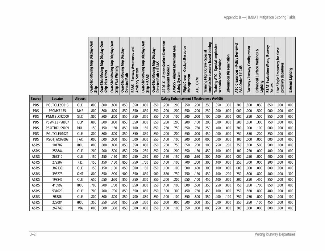
Appendix B — JIMDAT Mitigation Scoring Table
B–2 Wrong Runway Departures
Own-
Ship
Mov
ing
Map
Disp
lay-O
wn
Ship
Ow
n-Sh
ip M
ovin
g Ma
p Di
splay
-Own
Sh
ip P
lus O
ther
Ow
n-Sh
ip M
ovin
g Ma
p Di
splay
-Own
Sh
ip P
lus W
arni
ng
Own-
Ship
Mov
ing
Map
Disp
lay-
Dire
cted
Pat
h RA
AS -
Runw
ay A
ware
ness
and
Advis
ory S
yste
m
Own-
Ship
Mov
ing
Map
Disp
lay-O
wn
Ship
+ RA
AS
Own-
Ship
Mov
ing
Map
Disp
lay-
Dire
cted
Pat
h + R
AAS
ASDE
-X -
Airp
ort S
urfa
ce D
etec
tion
Equi
pmen
t Mod
el X
AMAS
S - A
irpor
t Mov
emen
t Are
a Sa
fety
Sys
tem
Fl
ight
Cre
ws -
Cock
pit R
esou
rce
Mana
gem
ent
ATC
CRM
Train
ing
Flig
ht C
rew
- Spe
cial
emph
asize
scen
ario
bas
ed tr
ainin
g Tr
ainin
g AT
C - S
pecia
l em
phas
ize
scen
ario
bas
ed tr
ainin
g
Info
rmat
ion
Diss
emin
atio
n
ATC
Clea
ranc
es -
Polic
y Rev
iew o
f FA
A Or
der 7
110.6
5
Taxiw
ay / R
unwa
y Con
figur
atio
n
Enha
nced
Sur
face
Mar
kings
&
Ligh
ting
RSAT
Eva
luat
ion-
Wro
ng R
unwa
y Iss
ues
Use S
ingl
e Fre
quen
cy fo
r clo
se
prox
imity
dep
artu
res
Exte
rnal
Ligh
ting
Source Locator Airport Safety Enhancement Effectiveness (%/100) PDS PGLTCLE95015 CLE .800 .800 .800 .850 .850 .850 .850 .200 .200 .250 .250 .250 .350 .350 .300 .850 .850 .850 .000 .000 PDS P90MKE135 MKE .800 .800 .800 .850 .850 .850 .850 .200 .200 .650 .200 .250 .200 .000 .000 .000 .500 .000 .000 .000 PDS PNMTSLC92009 SLC .800 .800 .800 .850 .850 .850 .850 .100 .100 .200 .000 .100 .000 .000 .000 .850 .500 .850 .000 .000 PDS PSWRELP98007 ELP .800 .800 .800 .850 .850 .850 .850 .200 .200 .200 .100 .200 .000 .000 .300 .650 .300 .750 .000 .000 PDS PSOTRDU99009 RDU .150 .150 .150 .850 .100 .150 .850 .750 .750 .650 .750 .250 .400 .000 .300 .000 .100 .000 .000 .000 PDS PGLTCLE01021 CLE .800 .800 .800 .850 .850 .850 .850 .200 .200 .650 .000 .450 .000 .000 .750 .850 .200 .850 .000 .000 PDS PSOTJAX98003 JAX .000 .000 .000 .850 .000 .000 .850 .100 .100 .200 .000 .000 .000 .000 .100 .000 .000 .000 .000 .000
ASRS 101787 HOU .800 .800 .800 .850 .850 .850 .850 .750 .750 .650 .200 .100 .250 .200 .750 .850 .500 .500 .000 .000 ASRS 256844 CLE .200 .200 .500 .850 .250 .250 .850 .200 .200 .650 .150 .450 .100 .000 .100 .250 .000 .400 .000 .000 ASRS 265310 CLE .150 .150 .150 .850 .250 .250 .850 .150 .150 .850 .650 .300 .100 .000 .000 .250 .000 .400 .000 .000 ASRS 279307 RIC .150 .150 .150 .850 .750 .750 .850 .100 .100 .700 .300 .300 .100 .000 .250 .700 .000 .200 .000 .000 ASRS 382130 CLE .150 .150 .150 .850 .000 .150 .850 .100 .100 .500 .450 .300 .100 .000 .000 .000 .000 .000 .000 .000 ASRS 393273 ONT .800 .850 .900 .900 .850 .850 .900 .850 .750 .750 .150 .450 .100 .200 .750 .800 .800 .400 .000 .300 ASRS 198846 CLE .650 .650 .650 .850 .850 .850 .850 .200 .200 .650 .100 .450 .100 .000 .200 .850 .450 .850 .000 .000 ASRS 415992 HOU .700 .700 .700 .850 .850 .850 .850 .100 .100 .600 .500 .350 .250 .000 .750 .850 .700 .850 .000 .000 ASRS 531029 CLE .700 .700 .700 .850 .850 .850 .850 .300 .300 .450 .750 .450 .100 .000 .750 .850 .800 .400 .000 .000 ASRS 96386 CLE .800 .800 .800 .850 .700 .850 .850 .100 .100 .350 .500 .350 .400 .100 .750 .750 .000 .450 .000 .100 ASRS 229084 HOU .350 .350 .350 .850 .350 .350 .850 .000 .000 .500 .000 .350 .000 .000 .350 .850 .100 .450 .000 .000 ASRS 267749 MIA .000 .000 .350 .850 .000 .000 .850 .100 .100 .350 .000 .000 .250 .000 .300 .000 .000 .000 .000 .000
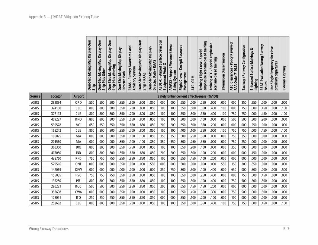
Appendix B — JIMDAT Mitigation Scoring Table
Wrong Runway Departures B–3
Own-
Ship
Mov
ing
Map
Disp
lay-O
wn
Ship
Ow
n-Sh
ip M
ovin
g Ma
p Di
splay
-Own
Sh
ip P
lus O
ther
Ow
n-Sh
ip M
ovin
g Ma
p Di
splay
-Own
Sh
ip P
lus W
arni
ng
Own-
Ship
Mov
ing
Map
Disp
lay-
Dire
cted
Pat
h RA
AS -
Runw
ay A
ware
ness
and
Advis
ory S
yste
m
Own-
Ship
Mov
ing
Map
Disp
lay-O
wn
Ship
+ RA
AS
Own-
Ship
Mov
ing
Map
Disp
lay-
Dire
cted
Pat
h + R
AAS
ASDE
-X -
Airp
ort S
urfa
ce D
etec
tion
Equi
pmen
t Mod
el X
AMAS
S - A
irpor
t Mov
emen
t Are
a Sa
fety
Sys
tem
Fl
ight
Cre
ws -
Cock
pit R
esou
rce
Mana
gem
ent
ATC
CRM
Train
ing
Flig
ht C
rew
- Spe
cial
emph
asize
scen
ario
bas
ed tr
ainin
g Tr
ainin
g AT
C - S
pecia
l em
phas
ize
scen
ario
bas
ed tr
ainin
g
Info
rmat
ion
Diss
emin
atio
n
ATC
Clea
ranc
es -
Polic
y Rev
iew o
f FA
A Or
der 7
110.6
5
Taxiw
ay / R
unwa
y Con
figur
atio
n
Enha
nced
Sur
face
Mar
kings
&
Ligh
ting
RSAT
Eva
luat
ion-
Wro
ng R
unwa
y Iss
ues
Use S
ingl
e Fre
quen
cy fo
r clo
se
prox
imity
dep
artu
res
Exte
rnal
Ligh
ting
Source Locator Airport Safety Enhancement Effectiveness (%/100) ASRS 282894 ORD .500 .500 .500 .850 .600 .600 .850 .000 .000 .650 .000 .250 .000 .000 .000 .350 .250 .000 .000 .000 ASRS 324130 CLE .800 .800 .800 .850 .700 .800 .850 .100 .100 .350 .500 .350 .400 .100 .000 .750 .000 .450 .000 .100 ASRS 327113 CLE .800 .800 .800 .850 .700 .800 .850 .100 .100 .350 .500 .350 .400 .100 .750 .750 .000 .450 .000 .100 ASRS 409227 RNO .800 .800 .800 .850 .650 .800 .850 .100 .100 .300 .000 .100 .000 .000 .500 .500 .300 .200 .000 .000 ASRS 539578 MCI .650 .650 .650 .850 .850 .850 .850 .200 .200 .650 .500 .350 .200 .000 .000 .000 .250 .000 .000 .000 ASRS 168242 CLE .800 .800 .800 .850 .700 .800 .850 .100 .100 .400 .100 .350 .000 .100 .750 .750 .000 .450 .000 .100 ASRS 196075 MIA .000 .000 .000 .850 .100 .100 .850 .350 .350 .500 .250 .350 .000 .000 .750 .250 .000 .000 .000 .000 ASRS 201560 MIA .000 .000 .000 .850 .100 .100 .850 .350 .350 .500 .250 .350 .000 .000 .750 .250 .000 .000 .000 .000 ASRS 360360 BOI .800 .800 .800 .850 .750 .800 .850 .100 .100 .650 .200 .100 .000 .000 .350 .000 .300 .000 .000 .000 ASRS 407080 IND .800 .800 .800 .850 .850 .850 .850 .200 .200 .650 .500 .100 .200 .000 .000 .000 .450 .000 .000 .000 ASRS 438760 RFD .750 .750 .750 .850 .850 .850 .850 .100 .000 .650 .450 .100 .200 .000 .000 .000 .000 .000 .000 .000 ASRS 579516 ONT .000 .000 .000 .550 .000 .000 .550 .000 .000 .300 .000 .000 .000 .550 .350 .200 .850 .000 .000 .000 ASRS 142069 DFW .000 .000 .000 .000 .000 .000 .000 .850 .750 .300 .500 .100 .400 .000 .650 .000 .500 .000 .000 .500 ASRS 155035 PSC .750 .750 .750 .850 .850 .850 .850 .100 .100 .650 .500 .250 .400 .000 .000 .750 .500 .450 .000 .000 ASRS 195280 PIE .800 .800 .800 .850 .850 .850 .850 .100 .100 .650 .500 .100 .400 .000 .750 .500 .500 .500 .000 .000 ASRS 290221 ROC .500 .500 .500 .850 .850 .850 .850 .200 .200 .650 .450 .150 .200 .000 .000 .000 .000 .000 .000 .000 ASRS 353698 CWA .000 .000 .000 .850 .000 .000 .850 .100 .100 .650 .450 .300 .300 .000 .750 .500 .000 .500 .000 .000 ASRS 128051 ITO .250 .250 .250 .850 .850 .850 .850 .000 .000 .350 .100 .200 .100 .000 .100 .000 .000 .000 .000 .000 ASRS 252682 CLE .800 .800 .800 .850 .700 .800 .850 .100 .100 .350 .500 .350 .400 .100 .750 .750 .000 .450 .000 .100

Appendix B — JIMDAT Mitigation Scoring Table
B–4 Wrong Runway Departures
Own-
Ship
Mov
ing
Map
Disp
lay-O
wn
Ship
Ow
n-Sh
ip M
ovin
g Ma
p Di
splay
-Own
Sh
ip P
lus O
ther
Ow
n-Sh
ip M
ovin
g Ma
p Di
splay
-Own
Sh
ip P
lus W
arni
ng
Own-
Ship
Mov
ing
Map
Disp
lay-
Dire
cted
Pat
h RA
AS -
Runw
ay A
ware
ness
and
Advis
ory S
yste
m
Own-
Ship
Mov
ing
Map
Disp
lay-O
wn
Ship
+ RA
AS
Own-
Ship
Mov
ing
Map
Disp
lay-
Dire
cted
Pat
h + R
AAS
ASDE
-X -
Airp
ort S
urfa
ce D
etec
tion
Equi
pmen
t Mod
el X
AMAS
S - A
irpor
t Mov
emen
t Are
a Sa
fety
Sys
tem
Fl
ight
Cre
ws -
Cock
pit R
esou
rce
Mana
gem
ent
ATC
CRM
Train
ing
Flig
ht C
rew
- Spe
cial
emph
asize
scen
ario
bas
ed tr
ainin
g Tr
ainin
g AT
C - S
pecia
l em
phas
ize
scen
ario
bas
ed tr
ainin
g
Info
rmat
ion
Diss
emin
atio
n
ATC
Clea
ranc
es -
Polic
y Rev
iew o
f FA
A Or
der 7
110.6
5
Taxiw
ay / R
unwa
y Con
figur
atio
n
Enha
nced
Sur
face
Mar
kings
&
Ligh
ting
RSAT
Eva
luat
ion-
Wro
ng R
unwa
y Iss
ues
Use S
ingl
e Fre
quen
cy fo
r clo
se
prox
imity
dep
artu
res
Exte
rnal
Ligh
ting
Source Locator Airport Safety Enhancement Effectiveness (%/100) ASRS 256788 LEX .800 .800 .800 .850 .850 .850 .850 .100 .100 .650 .250 .350 .100 .000 .550 .850 .650 .500 .000 .000 ASRS 320220 HOU .350 .350 .350 .850 .350 .350 .850 .000 .000 .450 .000 .350 .000 .000 .350 .850 .000 .450 .000 .000 ASRS 324652 CLE .800 .800 .800 .850 .700 .800 .850 .100 .100 .350 .500 .350 .400 .100 .000 .750 .000 .450 .000 .100 ASRS 420824 HOU .800 .800 .800 .850 .500 .800 .850 .000 .000 .650 .500 .350 .400 .000 .350 .650 .500 .250 .000 .000 ASRS 83934 HOU .500 .500 .500 .750 .850 .850 .850 .400 .400 .650 .200 .150 .150 .000 .750 .850 .250 .500 .000 .000 ASRS 180490 ISP .250 .250 .500 .850 .850 .850 .850 .200 .200 .500 .200 .250 .100 .000 .000 .850 .850 .500 .000 .100 ASRS 187280 CMX .250 .250 .250 .850 .250 .250 .850 .000 .000 .650 .000 .150 .000 .000 .100 .000 .000 .000 .000 .000 ASRS 260492 MEM .100 .100 .100 .850 .750 .750 .850 .350 .350 .350 .500 .150 .200 .000 .750 .000 .500 .000 .000 .000 ASRS 263236 MIA .800 .800 .800 .850 .850 .850 .850 .000 .000 .500 .000 .250 .150 .000 .150 .850 .850 .450 .000 .000 ASRS 329560 CLE .800 .800 .800 .850 .700 .800 .850 .100 .100 .350 .500 .350 .400 .100 .750 .750 .000 .450 .000 .100 ASRS 395904 SDF .250 .250 .500 .850 .850 .850 .850 .000 .000 .100 .100 .100 .000 .000 .100 .850 .200 .450 .000 .000 ASRS 194746 ORD .500 .500 .500 .850 .600 .600 .850 .000 .000 .650 .300 .250 .250 .000 .000 .350 .250 .000 .000 .000 ASRS 213976 EFD .200 .200 .200 .850 .500 .500 .850 .100 .100 .450 .000 .100 .000 .000 .000 .100 .250 .250 .000 .000 ASRS 226136 SLC .200 .200 .200 .850 .850 .850 .850 .100 .100 .450 .000 .250 .000 .000 .250 .350 .350 .450 .000 .000 ASRS 245145 CLE .200 .200 .550 .850 .000 .200 .850 .100 .100 .200 .250 .100 .250 .000 .500 .100 .000 .250 .000 .000 ASRS 322966 CLE .800 .800 .800 .850 .700 .800 .850 .100 .100 .450 .500 .350 .400 .100 .750 .750 .000 .450 .000 .100 ASRS 344740 PDX .000 .000 .000 .850 .350 .350 .850 .200 .200 .200 .000 .000 .000 .200 .000 .300 .300 .200 .000 .000 ASRS 438749 RFD .700 .700 .700 .850 .750 .750 .850 .200 .200 .350 .250 .200 .200 .000 .750 .000 .000 .000 .000 .000 ASRS 463977 MIA .000 .000 .000 .850 .000 .000 .850 .150 .150 .250 .250 .000 .100 .000 .400 .250 .000 .000 .000 .000
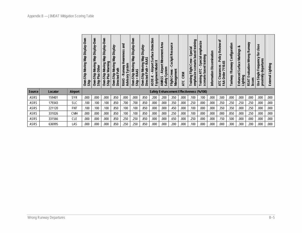
Appendix B — JIMDAT Mitigation Scoring Table
Wrong Runway Departures B–5
Own-
Ship
Mov
ing
Map
Disp
lay-O
wn
Ship
Ow
n-Sh
ip M
ovin
g Ma
p Di
splay
-Own
Sh
ip P
lus O
ther
Ow
n-Sh
ip M
ovin
g Ma
p Di
splay
-Own
Sh
ip P
lus W
arni
ng
Own-
Ship
Mov
ing
Map
Disp
lay-
Dire
cted
Pat
h RA
AS -
Runw
ay A
ware
ness
and
Advis
ory S
yste
m
Own-
Ship
Mov
ing
Map
Disp
lay-O
wn
Ship
+ RA
AS
Own-
Ship
Mov
ing
Map
Disp
lay-
Dire
cted
Pat
h + R
AAS
ASDE
-X -
Airp
ort S
urfa
ce D
etec
tion
Equi
pmen
t Mod
el X
AMAS
S - A
irpor
t Mov
emen
t Are
a Sa
fety
Sys
tem
Fl
ight
Cre
ws -
Cock
pit R
esou
rce
Mana
gem
ent
ATC
CRM
Train
ing
Flig
ht C
rew
- Spe
cial
emph
asize
scen
ario
bas
ed tr
ainin
g Tr
ainin
g AT
C - S
pecia
l em
phas
ize
scen
ario
bas
ed tr
ainin
g
Info
rmat
ion
Diss
emin
atio
n
ATC
Clea
ranc
es -
Polic
y Rev
iew o
f FA
A Or
der 7
110.6
5
Taxiw
ay / R
unwa
y Con
figur
atio
n
Enha
nced
Sur
face
Mar
kings
&
Ligh
ting
RSAT
Eva
luat
ion-
Wro
ng R
unwa
y Iss
ues
Use S
ingl
e Fre
quen
cy fo
r clo
se
prox
imity
dep
artu
res
Exte
rnal
Ligh
ting
Source Locator Airport Safety Enhancement Effectiveness (%/100) ASRS 159401 SYR .000 .000 .000 .850 .000 .000 .850 .200 .200 .350 .000 .100 .100 .000 .500 .000 .000 .000 .000 .000 ASRS 179343 SLC .100 .100 .100 .850 .700 .700 .850 .000 .000 .350 .000 .250 .000 .000 .350 .250 .250 .250 .000 .000 ASRS 221120 FNT .100 .100 .100 .850 .100 .100 .850 .000 .000 .450 .000 .100 .000 .000 .350 .350 .000 .250 .000 .000 ASRS 331026 CMH .000 .000 .000 .850 .100 .100 .850 .000 .000 .250 .000 .100 .000 .000 .000 .850 .000 .250 .000 .000 ASRS 331566 CLE .000 .000 .000 .850 .250 .250 .850 .000 .000 .650 .000 .250 .000 .000 .150 .500 .000 .000 .000 .000 ASRS 636995 LAS .000 .000 .000 .850 .250 .250 .850 .000 .000 .200 .000 .100 .000 .000 .000 .300 .300 .200 .000 .000

Wrong Runway Departures C–1
APPENDIX C — NOTAM PROCESS
NOTAM Acronym List and Explanation of Certain Terms
AIM Aeronautical Information Manual
ARTCC Air Route Traffic Control Center
DOD Department of Defense
DP departure procedures
FDC NOTAM Flight Data Center NOTAM (Information that is regulatory in nature including (a) interim instrument flight rules flight procedures (airway structure changes, instrument approach procedure changes excluding departure procedures and standard terminal arrivals, airspace changes in general, special instrument approach procedure changes); and (b) temporary flight restrictions (disaster areas, special events generating a high degree of interest, hijacking).)
FPO Flight Procedures Office
FSS Flight Service Station (An air traffic facility that provides pilot briefings regarding current weather and possible hazards along a route of flight; gives en route communication services and visual flight rules search and rescue assistance; relays air traffic control clearances; creates NOTAMs; receives instrument flight rules flight plans; and monitors navigation aids.)
HOO hours of operation
IFR instrument flight rules
NADIN National Airspace Data Interchange Network (Data communication system server used for data interchange within the United States, and between the United States and other nations to communicate flight plans for commercial and general aviation, weather, and advisory notices to pilots.)
NAS National Airspace System
NATP Notices to Airman Publication
NAVAID navigation aid
NFDC National Flight Data Center
Appendix C — NOTAM Process
C–2 Wrong Runway Departures
NOTAM D Wide dissemination NOTAM (Information distributed by means of telecommunications concerning the establishment, condition, or change in any aeronautical facility, service, procedure, or hazard, the timely knowledge of which is essential to personnel concerned with flight operations.)
NOTAM L Local dissemination NOTAM (Information that requires local dissemination.)
NOTAM Notice to Airman
ODP obstacle departure procedure
SID standard instrument departure
PJE parachute jumping/sky diving
SIAP standard instrument approach procedures
SMO System Management Office
STAR standard terminal arrivals
USNOF U.S. NOTAM Office
USNS U.S. NOTAM System
VFR visual flight rules
WMSCR Weather Message Switching Center Replacement (Network that serves as the Federal Aviation Administration gateway for the receipt and distribution of weather data and NOTAMs within the National Airspace System.)
Appendix C — NOTAM Process
Wrong Runway Departures C–3
Figure C–1. NOTAMs by Type and Who Initiates the NOTAM for What Type of Action
Appendix C — NOTAM Process
C–4 Wrong Runway Departures
Figure C–2. NOTAM Flow
Appendix C — NOTAM Process
Wrong Runway Departures C–5
Figure C–3. NOTAM Issuance and Distribution
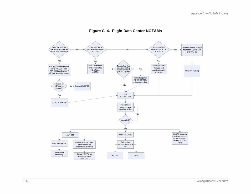
Appendix C — NOTAM Process
C–6 Wrong Runway Departures
Figure C–4. Flight Data Center NOTAMs
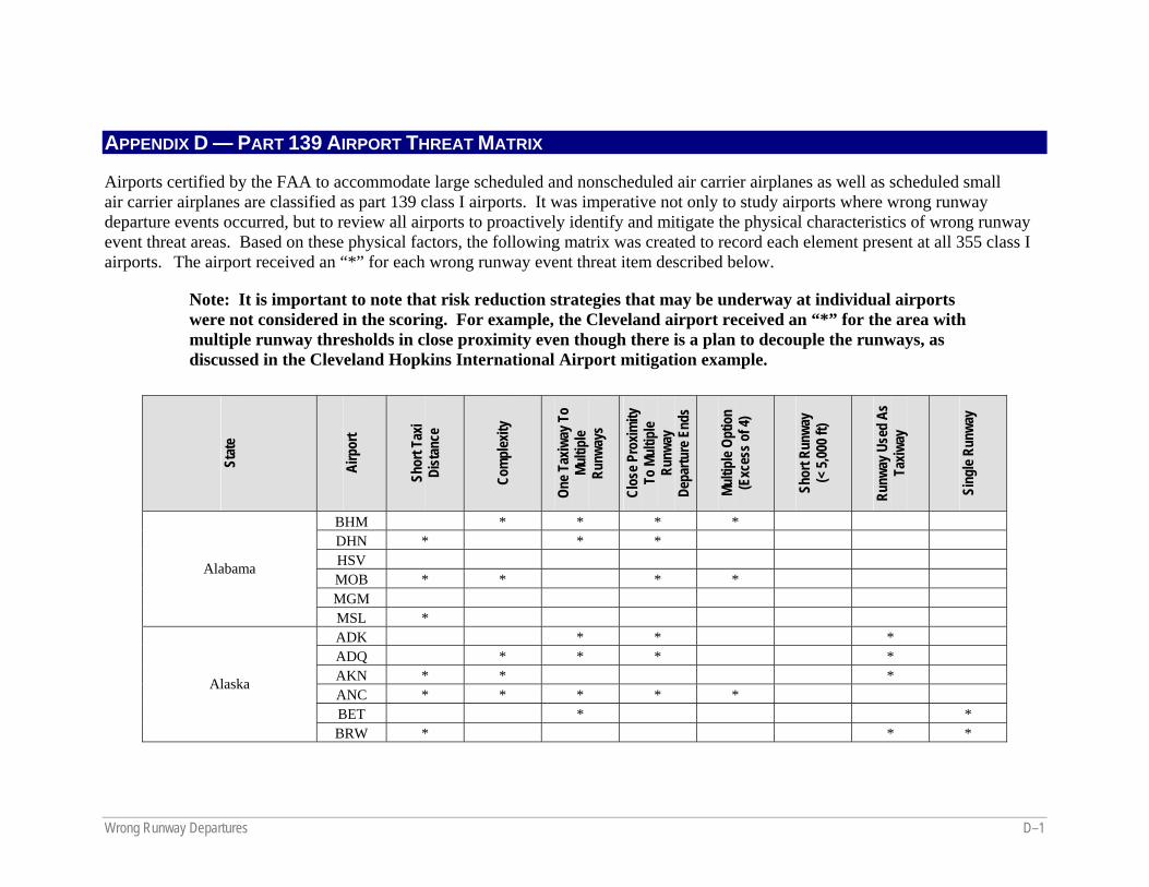
Wrong Runway Departures D–1
APPENDIX D — PART 139 AIRPORT THREAT MATRIX
Airports certified by the FAA to accommodate large scheduled and nonscheduled air carrier airplanes as well as scheduled small air carrier airplanes are classified as part 139 class I airports. It was imperative not only to study airports where wrong runway departure events occurred, but to review all airports to proactively identify and mitigate the physical characteristics of wrong runway event threat areas. Based on these physical factors, the following matrix was created to record each element present at all 355 class I airports. The airport received an “*” for each wrong runway event threat item described below.
Note: It is important to note that risk reduction strategies that may be underway at individual airports were not considered in the scoring. For example, the Cleveland airport received an “*” for the area with multiple runway thresholds in close proximity even though there is a plan to decouple the runways, as discussed in the Cleveland Hopkins International Airport mitigation example.
Stat
e
Airp
ort
Shor
t Tax
i Di
stan
ce
Com
plex
ity
One T
axiw
ay T
o Mu
ltipl
e Ru
nway
s
Clos
e Pro
ximity
To
Mul
tiple
Runw
ay
Depa
rture
End
s
Multi
ple O
ptio
n (E
xces
s of 4
)
Shor
t Run
way
(< 5,
000 f
t)
Runw
ay U
sed
As
Taxiw
ay
Sing
le Ru
nway
BHM * * * * DHN * * * HSV MOB * * * * MGM
Alabama
MSL * ADK * * * ADQ * * * * AKN * * * ANC * * * * * BET * *
Alaska
BRW * * *
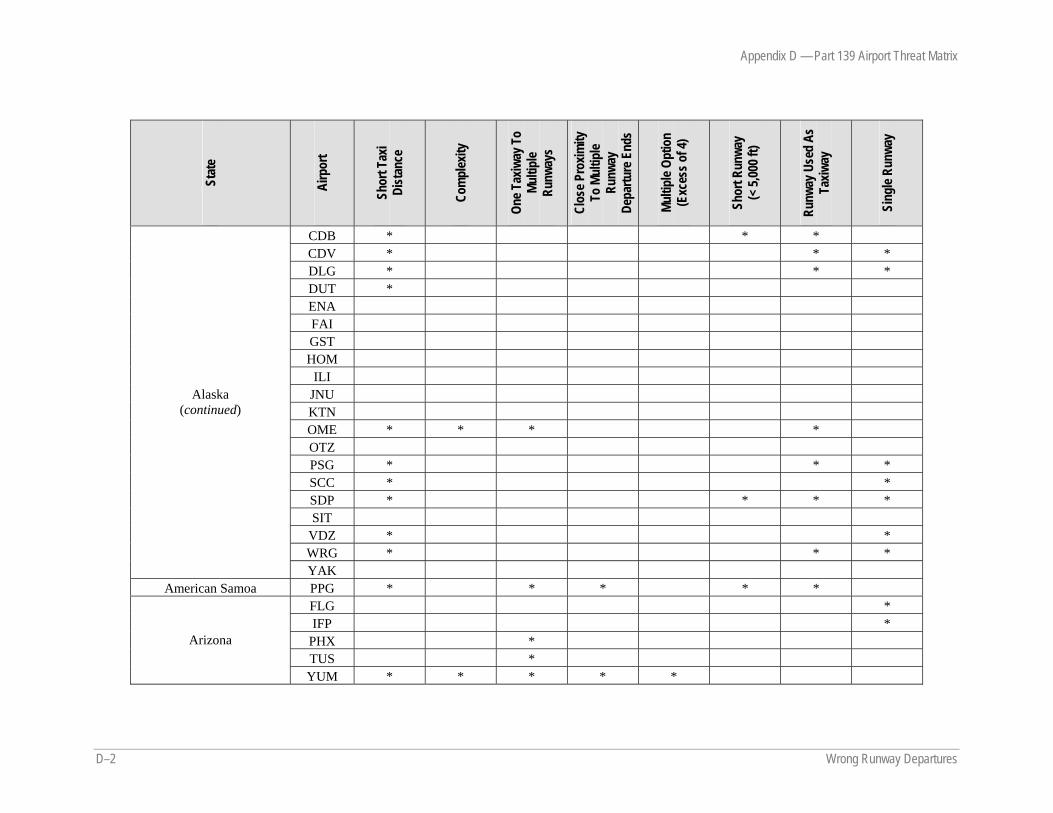
Appendix D — Part 139 Airport Threat Matrix
D–2 Wrong Runway Departures
Stat
e
Airp
ort
Shor
t Tax
i Di
stan
ce
Com
plex
ity
One T
axiw
ay T
o Mu
ltipl
e Ru
nway
s
Clos
e Pro
ximity
To
Mul
tiple
Runw
ay
Depa
rture
End
s
Multi
ple O
ptio
n (E
xces
s of 4
)
Shor
t Run
way
(< 5,
000 f
t)
Runw
ay U
sed
As
Taxiw
ay
Sing
le Ru
nway
CDB * * * CDV * * * DLG * * * DUT * ENA FAI GST HOM
ILI JNU KTN OME * * * * OTZ PSG * * * SCC * * SDP * * * * SIT
VDZ * * WRG * * *
Alaska (continued)
YAK American Samoa PPG * * * * *
FLG * IFP *
PHX * TUS *
Arizona
YUM * * * * *
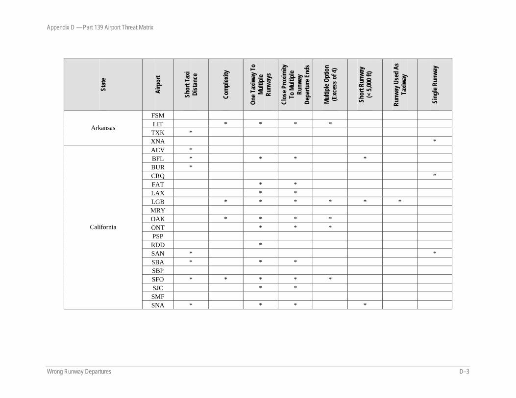
Appendix D — Part 139 Airport Threat Matrix
Wrong Runway Departures D–3
Stat
e
Airp
ort
Shor
t Tax
i Di
stan
ce
Com
plex
ity
One T
axiw
ay T
o Mu
ltipl
e Ru
nway
s
Clos
e Pro
ximity
To
Mul
tiple
Runw
ay
Depa
rture
End
s
Multi
ple O
ptio
n (E
xces
s of 4
)
Shor
t Run
way
(< 5,
000 f
t)
Runw
ay U
sed
As
Taxiw
ay
Sing
le Ru
nway
FSM LIT * * * *
TXK * Arkansas
XNA * ACV * BFL * * * * BUR * CRQ * FAT * * LAX * * LGB * * * * * * MRY OAK * * * * ONT * * * PSP RDD * SAN * * SBA * * * SBP SFO * * * * * SJC * * SMF
California
SNA * * * *
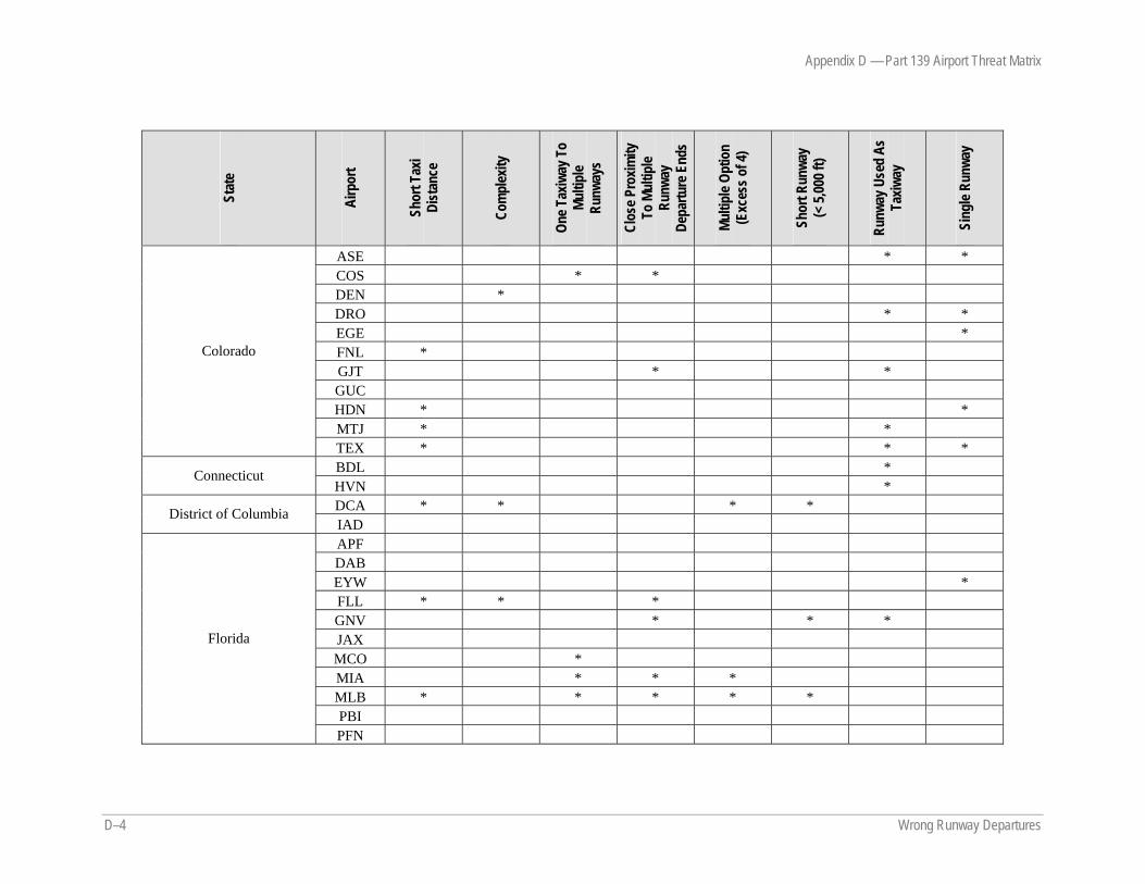
Appendix D — Part 139 Airport Threat Matrix
D–4 Wrong Runway Departures
Stat
e
Airp
ort
Shor
t Tax
i Di
stan
ce
Com
plex
ity
One T
axiw
ay T
o Mu
ltipl
e Ru
nway
s
Clos
e Pro
ximity
To
Mul
tiple
Runw
ay
Depa
rture
End
s
Multi
ple O
ptio
n (E
xces
s of 4
)
Shor
t Run
way
(< 5,
000 f
t)
Runw
ay U
sed
As
Taxiw
ay
Sing
le Ru
nway
ASE * * COS * * DEN * DRO * * EGE * FNL * GJT * * GUC HDN * * MTJ * *
Colorado
TEX * * * BDL * Connecticut HVN * DCA * * * * District of Columbia IAD APF DAB EYW * FLL * * * GNV * * * JAX MCO * MIA * * * MLB * * * * * PBI
Florida
PFN

Appendix D — Part 139 Airport Threat Matrix
Wrong Runway Departures D–5
Stat
e
Airp
ort
Shor
t Tax
i Di
stan
ce
Com
plex
ity
One T
axiw
ay T
o Mu
ltipl
e Ru
nway
s
Clos
e Pro
ximity
To
Mul
tiple
Runw
ay
Depa
rture
End
s
Multi
ple O
ptio
n (E
xces
s of 4
)
Shor
t Run
way
(< 5,
000 f
t)
Runw
ay U
sed
As
Taxiw
ay
Sing
le Ru
nway
PIE * * * * * PNS RSW * * SFB SRQ TLH TPA
Florida (continued)
VPS * * * ABY AGS * ATL * * CSG * MCN * * SAV
Georgia
VLD * * * * Guam GUM * * * *
HNL * * ITO JHM KOA * LIH LNY * * * MKK *
Hawaii
OGG * * *
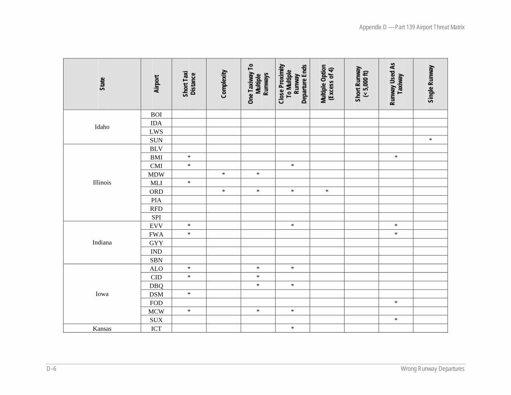
Appendix D — Part 139 Airport Threat Matrix
D–6 Wrong Runway Departures
Stat
e
Airp
ort
Shor
t Tax
i Di
stan
ce
Com
plex
ity
One T
axiw
ay T
o Mu
ltipl
e Ru
nway
s
Clos
e Pro
ximity
To
Mul
tiple
Runw
ay
Depa
rture
End
s
Multi
ple O
ptio
n (E
xces
s of 4
)
Shor
t Run
way
(< 5,
000 f
t)
Runw
ay U
sed
As
Taxiw
ay
Sing
le Ru
nway
BOI IDA LWS
Idaho
SUN * BLV BMI * * CMI * *
MDW * * MLI * ORD * * * * PIA RFD
Illinois
SPI EVV * * * FWA * * GYY IND
Indiana
SBN ALO * * * CID * * DBQ * * DSM * FOD *
MCW * * *
Iowa
SUX * Kansas ICT *
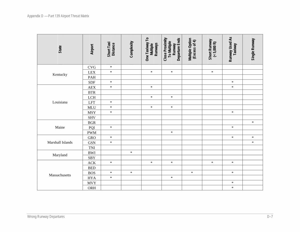
Appendix D — Part 139 Airport Threat Matrix
Wrong Runway Departures D–7
Stat
e
Airp
ort
Shor
t Tax
i Di
stan
ce
Com
plex
ity
One T
axiw
ay T
o Mu
ltipl
e Ru
nway
s
Clos
e Pro
ximity
To
Mul
tiple
Runw
ay
Depa
rture
End
s
Multi
ple O
ptio
n (E
xces
s of 4
)
Shor
t Run
way
(< 5,
000 f
t)
Runw
ay U
sed
As
Taxiw
ay
Sing
le Ru
nway
CVG * LEX * * * * PAH
Kentucky
SDF * * AEX * * * BTR LCH * * LFT * MLU * * * MSY * *
Louisiana
SHV BGR * PQI * * Maine
PWM * GRO * * * GSN * * Marshall Islands TNI BWI * Maryland SBY ACK * * * * * BED BOS * * * * HYA * * MVY *
Massachusetts
ORH *
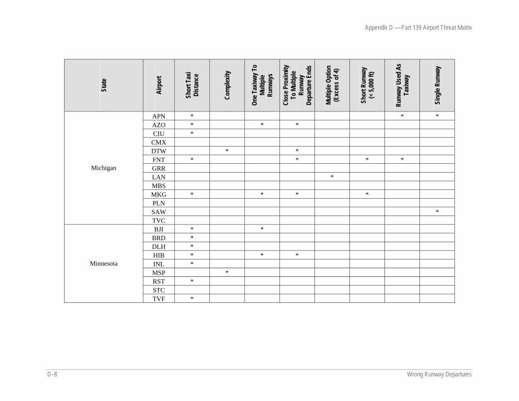
Appendix D — Part 139 Airport Threat Matrix
D–8 Wrong Runway Departures
Stat
e
Airp
ort
Shor
t Tax
i Di
stan
ce
Com
plex
ity
One T
axiw
ay T
o Mu
ltipl
e Ru
nway
s
Clos
e Pro
ximity
To
Mul
tiple
Runw
ay
Depa
rture
End
s
Multi
ple O
ptio
n (E
xces
s of 4
)
Shor
t Run
way
(< 5,
000 f
t)
Runw
ay U
sed
As
Taxiw
ay
Sing
le Ru
nway
APN * * * AZO * * * CIU *
CMX DTW * * FNT * * * * GRR LAN * MBS MKG * * * * PLN SAW *
Michigan
TVC BJI * *
BRD * DLH * HIB * * * INL * MSP * RST * STC
Minnesota
TVF *

Appendix D — Part 139 Airport Threat Matrix
Wrong Runway Departures D–9
Stat
e
Airp
ort
Shor
t Tax
i Di
stan
ce
Com
plex
ity
One T
axiw
ay T
o Mu
ltipl
e Ru
nway
s
Clos
e Pro
ximity
To
Mul
tiple
Runw
ay
Depa
rture
End
s
Multi
ple O
ptio
n (E
xces
s of 4
)
Shor
t Run
way
(< 5,
000 f
t)
Runw
ay U
sed
As
Taxiw
ay
Sing
le Ru
nway
GLH * * GPT * * GTR * JAN MEI PIB * *
Mississippi
TUP * MCI * * * SGF * Missouri STL * * * * BIL * * *
BTM BZN * FCA GTF * * * HLN * * *
Montana
MSO LNK * * * Nebraska OMA * * * * EKO * * * LAS * * * * Nevada RNO * * * MHT New Hampshire PSM * ACY New Jersey EWR * * *
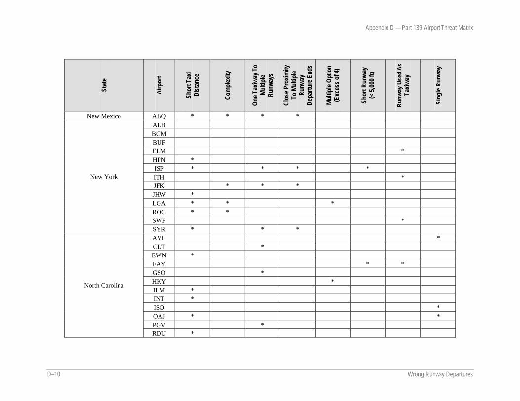
Appendix D — Part 139 Airport Threat Matrix
D–10 Wrong Runway Departures
Stat
e
Airp
ort
Shor
t Tax
i Di
stan
ce
Com
plex
ity
One T
axiw
ay T
o Mu
ltipl
e Ru
nway
s
Clos
e Pro
ximity
To
Mul
tiple
Runw
ay
Depa
rture
End
s
Multi
ple O
ptio
n (E
xces
s of 4
)
Shor
t Run
way
(< 5,
000 f
t)
Runw
ay U
sed
As
Taxiw
ay
Sing
le Ru
nway
New Mexico ABQ * * * * ALB BGM BUF ELM * HPN * ISP * * * * ITH * JFK * * * JHW * LGA * * * ROC * * SWF *
New York
SYR * * * AVL * CLT * EWN * FAY * * GSO * HKY * ILM * INT * ISO * OAJ * * PGV *
North Carolina
RDU *
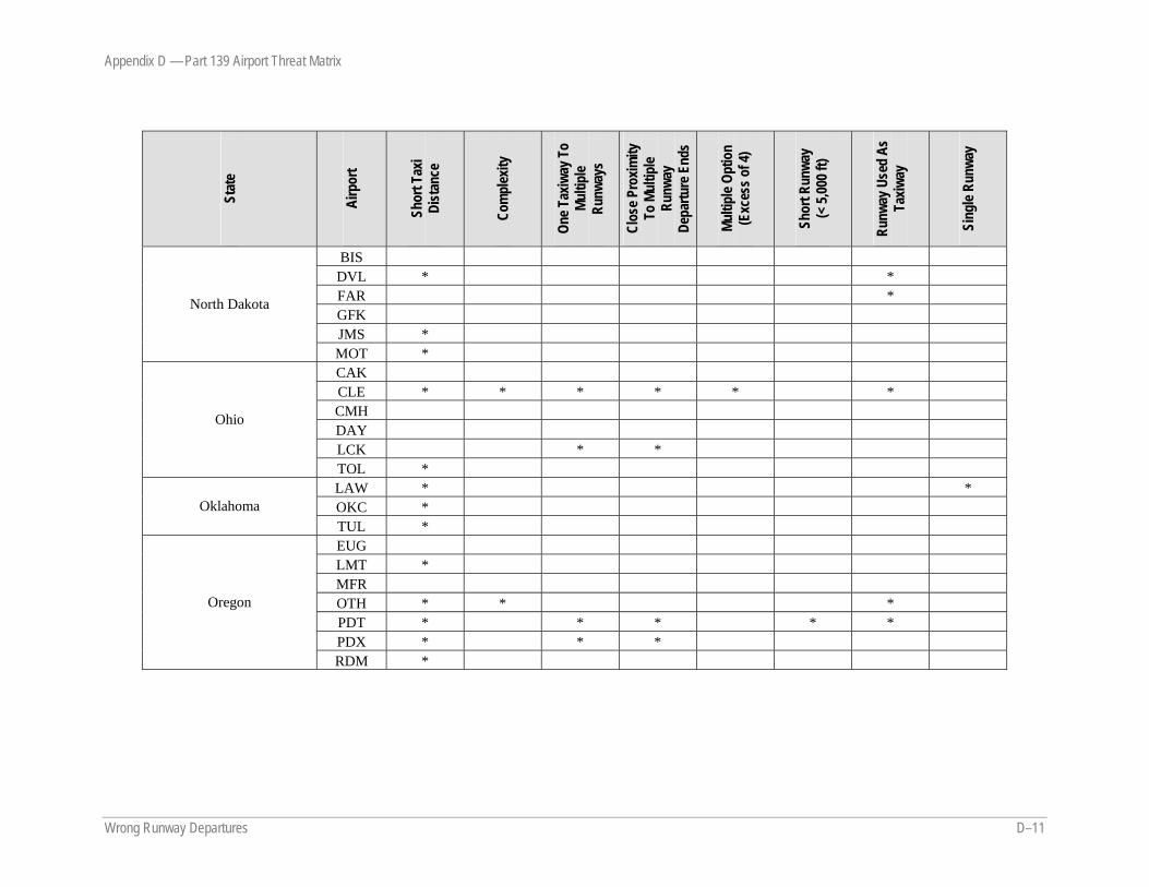
Appendix D — Part 139 Airport Threat Matrix
Wrong Runway Departures D–11
Stat
e
Airp
ort
Shor
t Tax
i Di
stan
ce
Com
plex
ity
One T
axiw
ay T
o Mu
ltipl
e Ru
nway
s
Clos
e Pro
ximity
To
Mul
tiple
Runw
ay
Depa
rture
End
s
Multi
ple O
ptio
n (E
xces
s of 4
)
Shor
t Run
way
(< 5,
000 f
t)
Runw
ay U
sed
As
Taxiw
ay
Sing
le Ru
nway
BIS DVL * * FAR * GFK JMS *
North Dakota
MOT * CAK CLE * * * * * * CMH DAY LCK * *
Ohio
TOL * LAW * * OKC * Oklahoma TUL * EUG LMT * MFR OTH * * * PDT * * * * * PDX * * *
Oregon
RDM *
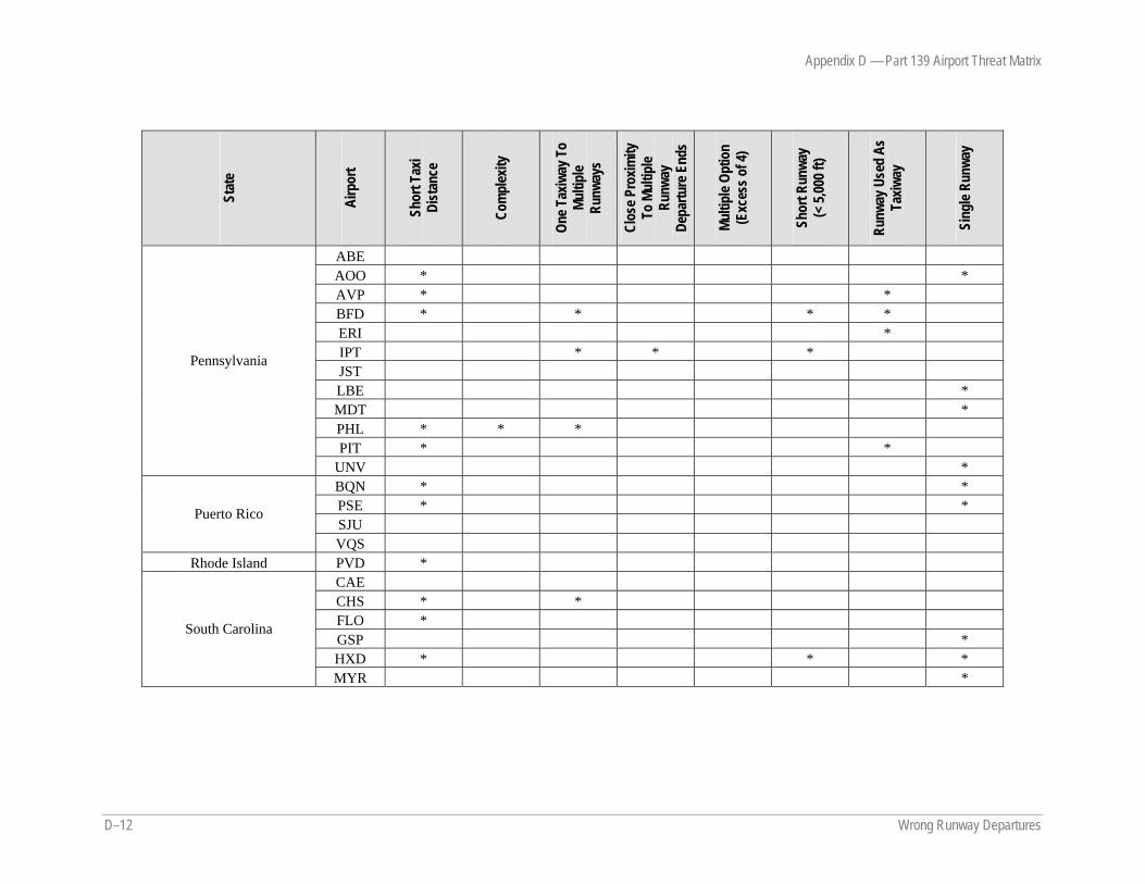
Appendix D — Part 139 Airport Threat Matrix
D–12 Wrong Runway Departures
Stat
e
Airp
ort
Shor
t Tax
i Di
stan
ce
Com
plex
ity
One T
axiw
ay T
o Mu
ltipl
e Ru
nway
s
Clos
e Pro
ximity
To
Mul
tiple
Runw
ay
Depa
rture
End
s
Multi
ple O
ptio
n (E
xces
s of 4
)
Shor
t Run
way
(< 5,
000 f
t)
Runw
ay U
sed
As
Taxiw
ay
Sing
le Ru
nway
ABE AOO * * AVP * * BFD * * * * ERI * IPT * * * JST LBE * MDT * PHL * * * PIT * *
Pennsylvania
UNV * BQN * * PSE * * SJU
Puerto Rico
VQS Rhode Island PVD *
CAE CHS * * FLO * GSP * HXD * * *
South Carolina
MYR *
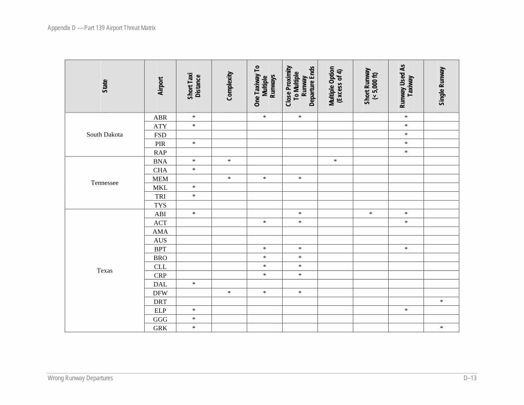
Appendix D — Part 139 Airport Threat Matrix
Wrong Runway Departures D–13
Stat
e
Airp
ort
Shor
t Tax
i Di
stan
ce
Com
plex
ity
One T
axiw
ay T
o Mu
ltipl
e Ru
nway
s
Clos
e Pro
ximity
To
Mul
tiple
Runw
ay
Depa
rture
End
s
Multi
ple O
ptio
n (E
xces
s of 4
)
Shor
t Run
way
(< 5,
000 f
t)
Runw
ay U
sed
As
Taxiw
ay
Sing
le Ru
nway
ABR * * * * ATY * * FSD * PIR * *
South Dakota
RAP * BNA * * * CHA * MEM * * * MKL * TRI *
Tennessee
TYS ABI * * * * ACT * * * AMA AUS BPT * * * BRO * * CLL * * CRP * * DAL * DFW * * * DRT * ELP * * GGG *
Texas
GRK * *
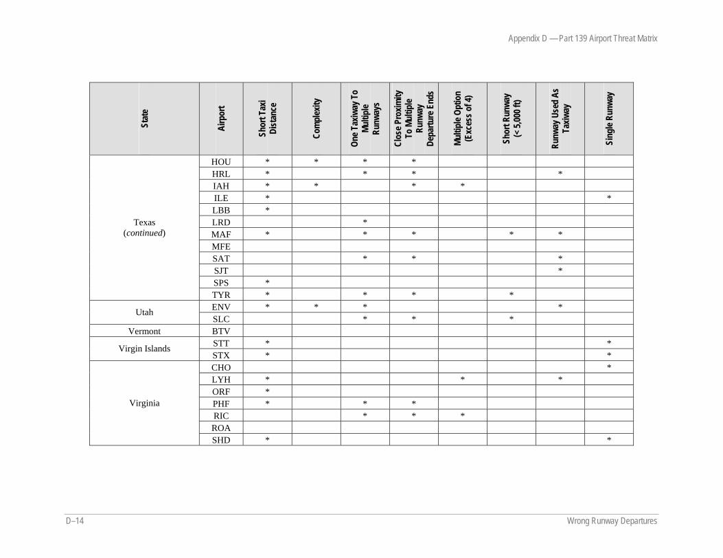
Appendix D — Part 139 Airport Threat Matrix
D–14 Wrong Runway Departures
Stat
e
Airp
ort
Shor
t Tax
i Di
stan
ce
Com
plex
ity
One T
axiw
ay T
o Mu
ltipl
e Ru
nway
s
Clos
e Pro
ximity
To
Mul
tiple
Runw
ay
Depa
rture
End
s
Multi
ple O
ptio
n (E
xces
s of 4
)
Shor
t Run
way
(< 5,
000 f
t)
Runw
ay U
sed
As
Taxiw
ay
Sing
le Ru
nway
HOU * * * * HRL * * * * IAH * * * * ILE * * LBB * LRD * MAF * * * * * MFE SAT * * * SJT * SPS *
Texas (continued)
TYR * * * * ENV * * * * Utah SLC * * *
Vermont BTV STT * * Virgin Islands STX * * CHO * LYH * * * ORF * PHF * * * RIC * * * ROA
Virginia
SHD * *
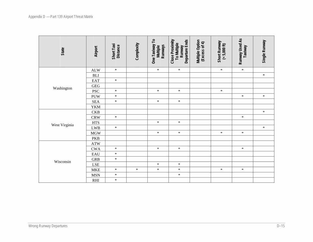
Appendix D — Part 139 Airport Threat Matrix
Wrong Runway Departures D–15
Stat
e
Airp
ort
Shor
t Tax
i Di
stan
ce
Com
plex
ity
One T
axiw
ay T
o Mu
ltipl
e Ru
nway
s
Clos
e Pro
ximity
To
Mul
tiple
Runw
ay
Depa
rture
End
s
Multi
ple O
ptio
n (E
xces
s of 4
)
Shor
t Run
way
(< 5,
000 f
t)
Runw
ay U
sed
As
Taxiw
ay
Sing
le Ru
nway
ALW * * * * * BLI * EAT * GEG PSC * * * * PUW * * * SEA * * *
Washington
YKM CKB * CRW * * HTS * * LWB * * MGW * * * *
West Virginia
PKB ATW CWA * * * * EAU * GRB * LSE * * MKE * * * * * * MSN * *
Wisconsin
RHI *
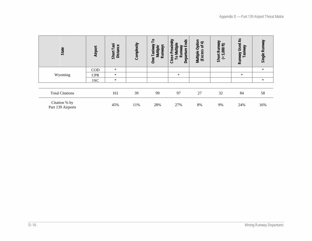
Appendix D — Part 139 Airport Threat Matrix
D–16 Wrong Runway Departures
Stat
e
Airp
ort
Shor
t Tax
i Di
stan
ce
Com
plex
ity
One T
axiw
ay T
o Mu
ltipl
e Ru
nway
s
Clos
e Pro
ximity
To
Mul
tiple
Runw
ay
Depa
rture
End
s
Multi
ple O
ptio
n (E
xces
s of 4
)
Shor
t Run
way
(< 5,
000 f
t)
Runw
ay U
sed
As
Taxiw
ay
Sing
le Ru
nway
COD * * CPR * * * Wyoming JAC * *
Total Citations 161 39 99 97 27 32 84 58
Citation % by Part 139 Airports
45% 11% 28% 27% 8% 9% 24% 16%