Embed Size (px)
Citation preview

CORI Project: 2010-11 July 2010
FLIGHT REPORT ShoreZone Aerial Video Imaging (AVI) Survey
Southeast Alaska May 27-29, 2010
Team Humpback (HB) June 11-16, 2010 Team Kuiu (KU)
Prepared for: NOAA National Marine Fisheries Service
The Nature Conservancy Alaska State Department of Natural Resources
By:
COASTAL & OCEAN RESOURCES INC. 300 – 759 Vanalman Avenue. Victoria, BC. V8Z 3B8. Canada
ph: 250.658.4050, web: www.coastalandoceans.com, email: [email protected]


1
SUMMARY
ShoreZone is a coastal habitat mapping and classification system in which georeferenced aerial imagery is collected specifically for the interpretation and integration of geological and biological features of the intertidal zone and nearshore environment. Oblique low-altitude aerial video and digital still imagery of the coastal zone is collected during summer low tides (zero tide level or lower), usually from a helicopter flying at <100 m altitude. The flight trackline is recorded at 1-second intervals using Fugawi electronic navigation software and is continuously monitored in-flight to ensure all shorelines have been imaged. Video and still imagery collected are georeferenced and time-synchronized. Video imagery is accompanied by continuous, simultaneous commentary by a geologist and a biologist aboard the aircraft. The imagery and commentary are later used in the definition of discrete along-shore coastal habitat units and the “mapping” of observed physical, geomorphic, sedimentary, and biological features in those units. More than 20 agencies and groups support the ShoreZone Coastal Habitat Mapping Program in Alaska. For more information on the ShoreZone program and its partners, please visit Coastal and Ocean Resources, Inc. web site at http://www.coastalandoceans.com. The purpose of this flight report is to summarize the field activities of the ShoreZone aerial video imaging (AVI) survey conducted out of Juneau and around Kuiu Island, Southeast Alaska during the low-tide windows of May 27-29 and June 11-16 respectively, 2010. The survey was conducted by Coastal & Ocean Resources Inc. (CORI) under contract with NOAA National Marine Fisheries Service, the Alaska State Department of Natural Resources, and The Nature Conservancy. A coastal ecologist from Archipelago Marine Resources (AMR) provided biological observations during the flights. Tables 2 & 3 provide a summary of crew affiliations and responsibilities. The tables and figures on the following pages summarize the extent and location of the AVI data and imagery collected by each team, a total of 2,355 km of shoreline. The teams utilized helicopters charted from Coastal Helicopters in Juneau, Alaska. Imagery was collected looking at the shoreline from the left side of the aircraft with the rear door removed. A total of 29 mini DV master tapes were collected during the survey and recorded to DVDs (20 tapes for team Kuiu and 9 for team Humpback). This report contains a summary table for each tape, illustrating its location, length, and key geographic points. Maps for each tape are annotated with representative geographic names, trackline times (in hh:mm:ss UTC in 24-hour clock time; UTC time is 8 hours ahead of Alaska Daylight Time), and photo numbers. The six-digit UTC time is also imprinted on the video imagery that is provided on DVDs with this report. Representative digital still photos from each day of the surveys are provided in the last section of this report. All photos are supplied on DVD, organized by tape number for each team, consistent with the image library. More than 19,100 photos were collected by the team. The shapefiles and GIS data that accompany this report on DVD illustrate the flight trackline positions at 1-second intervals (displayed by tape number), as well as the digital shoreline segments flown. Within each survey, data and imagery are linked by a date time code (yyyymmddhhmmss). When processing is complete, all imagery will be posted online at the NOAA ShoreZone web site (http://www.fakr.noaa.gov/maps/szintro.htm).

2
Table 1. Survey teams and flight report contents.
Team Details Pages Humpback
(HB)
Tapes: SE10_HB_01 to SE10_HB_09
5 - 24
Kuiu (KU)
Tapes: SE10_KU_01 to SE10_KU_20
25 - 66
Daily sample photos 67 - 75
References, Acknowledgments, and Use
Constraints
76

3
Table 2. ShoreZone AVI Flight Personnel and Responsibilities: Team Humpback (HB)
Crew Member Individual / Affiliation Responsibilities Geomorphologist Kalen Morrow
CORI, Sidney, BC survey coordination, videography, geomorphic commentary, post-flight data processing, project reporting
Coastal Ecologist Mandy Lindeburg NOAA, Juneau, AK
digital photography, biologic commentary
Navigator Steve Lewis NOAA, Juneau, AK
in-flight navigation, post-flight data processing
Pilot Bill Snider Coastal Helicopters Juneau, Alaska
Table 3. ShoreZone AVI Flight Personnel and Responsibilities: Team Kuiu (KU)
Crew Member Individual / Affiliation Responsibilities Geomorphologist John Harper / Sean Daley
CORI, Sidney, BC survey coordination, videography, geomorphic commentary, post-flight data processing, project reporting
Coastal Ecologist Mary Morris AMR, Victoria, BC
digital photography, biologic commentary
Navigators John Harper / Sean DaleyCORI, Sidney, BC
in-flight navigation, post-flight data processing
Pilot Bill Snider Coastal Helicopters Juneau, Alaska

4
Table 4. Survey Tapes for Team Humpback (HB).
Team Tape Location Humpback SE10_HB_01 Lemesurier, Inian Islands, Icy Strait (HB) SE10_HB_02 Lemesurier Island, Icy Strait SE10_HB_03 Cape Fanshaw, Farragut Bay, Frederick Sound SE10_HB_04 Thomas Bay, Frederick Sound SE10_HB_05 Ruth Island, Bock Bight, Thomas Bay SE10_HB_06 Keku Islands, Keku Strait SE10_HB_07 Keku Islands, Saginaw Bay, North Kuiu Island SE10_HB_08 Saginaw Bay, Security Bay, North Kuiu Island SE10_HB_09 North Kuiu Island, Frederick Sound, Keku Strait
Table 5. Survey Tapes for Team Kuiu (KU).
Team Tape Location Kuiu SE10_KU_01 Washington Bay, Rowan Bay (KU) SE10_KU_02 Bay of Pillars, Pt Ellis, Happy Cove SE10_KU_03 Elana Bay, Tebenkof Bay SE10_KU_04 Tebenkof Bay, Honeymoon Basin (Bay of Pillars) SE10_KU_05 Tebenkof Bay, Petrof Bay SE10_KU_06 Tebenkof Bay, Thetis Bay, Troller Islands SE10_KU_07 Chatham Strait, Port Malsmesbury SE10_KU_08 Chatham Strait, Table Bay SE10_KU_09 Sumner Island, Conclusion Island, No Name Bay SE10_KU_10 No Name Bay, Seclusion Harbor, Threemile Arm SE10_KU_11 Threemile Arm, Rocky Pass SE10_KU_12 Rocky Pass, Port Camden, Alvin Bay SE10_KU_13 Chatham Strait, Cape Decision, Port McArthur SE10_KU_14 Kell Bay, Bear Harbor, Affleck Canal SE10_KU_15 Affleck Canal, Sumner Strait, Louise Cove SE10_KU_16 Port Beauclerc, Edwards Island SE10_KU_17 Spanish Islands, Coronation Island SE10_KU_18 Warren Island, Kosciusko Island SE10_KU_19 Kosciusko Island, Green Island, Edna Bay SE10_KU_20 Sumner Strait, Reid Bay

5
ShoreZone Aerial Video Imaging (AVI) Survey Southeast Alaska May 27-29, 2010
Team Humpback (HB)
Survey Maps and Tape Logs DVDs: SE10_HB_01 to SE10_HB_09
Flight trackline map showing the location and extent of specific videotapes (DVDs) for the May 27-29,
2010 Team Humpback survey in Southeast Alaska

6

7
2010 Southeast Alaska Aerial Video Imaging Survey Team Humpback (HB)
Tape: SE10_HB_01 Date: 27 May 2010 General Location: Lemesurier, Inian Islands, Icy Strait Time Start (UTC): 14:00:40 Geo: Morrow Fuel Break: 14:05:49 to 14:47:47 Bio: Lindeberg Time End (UTC): 15:39:30 Nav: Lewis Tape Length: 49 min 59 sec Pilot: Snider Weather: Sunny and clear
Time (UTC)
Location
Photo
14:00:46 The Sisters, Icy Strait se10_hb_00001 Transit to Spasski Island 14:02:58 to 14:04:27
14:04:37 Spasski Island, Icy Strait se10_hb_00038 Fuel Break 14:05:49 to 14:47:47
14:48:10 North Pt. of Lemesurier Island se10_hb_00063 14:54:27 West Pt. of Lemesurier Island se10_hb_00160
Transit to Inian Islands 14:54:39 to 14:57:37 15:06:05 Inian Cove, Inian Islands se10_hb_00299
Transit to George Island 15:19:57 to 15:21:01 15:23:31 George Island, Cross Sound se10_hb_00571
Transit to Inian Islands 15:27:51 to 15:29:03 15:39:30 NE corner of the Inian Islands se10_hb_00841

8

9
2010 Southeast Alaska Aerial Video Imaging Survey Team Humpback (HB)
Tape: SE10_HB_02 Date: 27 May 2010 General Location: Lemesurier Island, Icy Strait Time Start (UTC): 15:42:55 Geo: Morrow Fuel Break: None Bio: Lindeberg Time End (UTC): 15:52:30 Nav: Lewis Tape Length: 9 min 35 sec Pilot: Snider Weather: Sunny and clear
Time (UTC)
Location
Photo
15:43:04 West Pt. of Lemesurier Island se10_hb_00842 15:46:06 Iceberg Pt., Lemesurier Island se10_hb_00911 15:47:54 Willoughby Cove, Lemesurier Island se10_hb_00958 15:52:21 North Pt. of Lemesurier Island se10_hb_01024

10

11
2010 Southeast Alaska Aerial Video Imaging Survey Team Humpback (HB)
Tape: SE10_HB_03 Date: 28 May 2010 General Location: Cape Fanshaw, Farragut Bay, Frederick Sound Time Start (UTC): 14:26:06 Geo: Morrow Fuel Break: None Bio: Lindeberg Time End (UTC): 15:24:06 Nav: Lewis Tape Length: 55 min 41 sec Pilot: Snider Weather: Sunny, high overcast
Time (UTC)
Location
Photo
14:26:10 Storm Island reefs se10_hb_01027 Transit to Fanshaw Bay 14:29:40 to 14:31:57
14:35:33 Cape Fanshaw se10_hb_01125 14:44:08 Bay Pt., Farragut Bay se10_hb_01247 14:59:38 Francis Anchorage, Farragut Bay se10_hb_01444 15:15:23 Grand Pt., Farragut Bay se10_hb_01638 15:24:03 Lagoon north of Pt. Vandeput se10_hb_01737

12

13
2010 Southeast Alaska Aerial Video Imaging Survey Team Humpback (HB)
Tape: SE10_HB_04 Date: 28 May 2010 General Location: Thomas Bay, Frederick Sound Time Start (UTC): 15:25:00 Geo: Morrow Fuel Break: ` 15:54:31 to 16:30:09 Bio: Lindeberg Time End (UTC): 16:57:20 Nav: Lewis Tape Length: 54 min 54 sec Pilot: Snider Weather: Sunny, high overcast
Time (UTC)
Location
Photo
15:25:13 North of Pt. Vandeput, Frederick Sound se10_hb_01740 15:35:24 Spurt Pt., Thomas Bay se10_hb_01850
Transit to Wood Pt. 15:35:29 to 15:37:13 15:37:27 Wood Pt., Frederick Sound se10_hb_01853 15:43:01 Pt. Agassiz, Frederick Sound se10_hb_01896 15:54:14 McDonald Islands, Frederick Sound se10_hb_02006
Fuel Break 15:54:31 to 16:30:09 16:30:16 Spurt Pt., Thomas Bay se10_hb_02007 16:42:13 Scenery Cove, Thomas Bay se10_hb_02175 16:57:16 Thomas Bay near Patterson Glacier River terminal se10_hb_02348

14

15
2010 Southeast Alaska Aerial Video Imaging Survey Team Humpback (HB)
Tape: SE10_HB_05 Date: 28 May 2010 General Location: Ruth Island, Bock Bight, Thomas Bay Time Start (UTC): 16:58:12 Geo: Morrow Fuel Break: None Bio: Lindeberg Time End (UTC): 17:23:08 Nav: Lewis Tape Length: 24 min 56 sec Pilot: Snider Weather: Sunny, high overcast
Time (UTC)
Location
Photo
16:58:14 Thomas Bay near Patterson Glacier River terminal se10_hb_02349 17:05:14 South Ruth Island, Thomas Bay se10_hb_02426 17:11:44 North Ruth Island, Thomas Bay se10_hb_02507 17:16:54 Bock Bight se10_hb_02551 17:22:55 Wood Pt., Frederick Sound se10_hb_02624

16

17
2010 Southeast Alaska Aerial Video Imaging Survey Team Humpback (HB)
Tape: SE10_HB_06 Date: 29 May 2010 General Location: Keku Islands, Keku Strait Time Start (UTC): 14:42:44 Geo: Morrow Fuel Break: None Bio: Lindeberg Time End (UTC): 15:39:50 Nav: Lewis Tape Length: 54 min 30 sec Pilot: Snider Weather: Sunny, scattered low lying fog
Time (UTC)
Location
Photo
14:42:45 Hound Island, Keku Strait se10_hb_02626 14:56:34 Kousk Island, Keku Strait se10_hb_02787
Transit to Gil Harbor 15:00:45 to 15:03:19 15:03:20 Gil Harbor, North Kuiu Island se10_hb_02832 15:15:49 Keku Islands, Keku Strait se10_hb_02973 15:29:45 Keku Islands, Keku Strait se10_hb_03166 15:39:46 Payne Island, Keku Strait se10_hb_03310

18

19
2010 Southeast Alaska Aerial Video Imaging Survey Team Humpback (HB)
Tape: SE10_HB_07 Date: 29 May 2010 General Location: Keku Islands, Saginaw Bay, North Kuiu Island Time Start (UTC): 15:40:52 Geo: Morrow Fuel Break: None Bio: Lindeberg Time End (UTC): 16:38:32 Nav: Lewis Tape Length: 55 min 37 sec Pilot: Snider Weather: Sunny, scattered low lying fog
Time (UTC)
Location
Photo
15:41:02 Keku Islands, Keku Strait se10_hb_03314 15:53:23 North Kuiu Island, Keku Strait se10_hb_03454 16:10:16 North Kuiu Island, Keku Strait se10_hb_03661
Fog Break 16:10:31 to 16:12:32 16:12:33 Cornwallis Pt., North Kuiu Island se10_hb_03662 16:18:20 Halleck Harbor, Saginaw Bay se10_hb_03735 16:28:56 Straight Creek, head of Saginaw Bay se10_hb_03856 16:38:27 Islets at head of Saginaw Bay se10_hb_03968

20

21
2010 Southeast Alaska Aerial Video Imaging Survey Team Humpback (HB)
Tape: SE10_HB_08 Date: 29 May 2010 General Location: Saginaw Bay, Security Bay, North Kuiu Island Time Start (UTC): 17:19:42 Geo: Morrow Fuel Break: None Bio: Lindeberg Time End (UTC): 18:17:50 Nav: Lewis Tape Length: 54 min 58 sec Pilot: Snider Weather: Sunny, scattered low lying fog
Time (UTC)
Location
Photo
17:19:52 North Kuiu Island, Keku Strait se10_hb_03971 17:25:42 Cornwallis Pt., North Kuiu Island se10_hb_04052
Transit to Sachem Island 17:25:43 to 17:27:49 17:28:08 Sachem Island, Saginaw Bay se10_hb_04059
Transit to Saginaw Bay Islets 17:28:35 to 17:29:35 17:32:35 Islets at the head of Saginaw Bay se10_hb_04091 17:45:07 Meade Pt., Frederick Sound se10_hb_04262 17:52:58 Cedar Bight, Security Bay se10_hb_04372 18:07:52 Head of Security Bay se10_hb_04568 18:17:50 Paralysis Pt., Frederick Sound se10_hb_04710

22

23
2010 Southeast Alaska Aerial Video Imaging Survey Team Humpback (HB)
Tape: SE10_HB_09 Date: 29 May 2010 General Location: North Kuiu Island, Frederick Sound, Keku Strait Time Start (UTC): 18:18:40 Geo: Morrow Fuel Break: None Bio: Lindeberg Time End (UTC): 18:36:04 Nav: Lewis Tape Length: 7 min 54 sec Pilot: Snider Weather: Sunny, scattered low lying fog
Time (UTC)
Location
Photo
18:18:42 Christmas Island, Security Bay se10_hb_04711 18:23:10 Kingsmill Pt., Chatham Strait se10_hb_04790 18:24:51 Hourigan Pt., North Kuiu Island se10_hb_04794
Transit to Keku Islands 18:24:59 to 18:34:27 18:36:01 Keku Islands, Keku Strait se10_hb_04830

24

25
ShoreZone Aerial Video Imaging (AVI) Survey Southeast Alaska June 11-16, 2010
Team Kuiu (KU)
Survey Maps and Tape Logs DVDs: SE10_KU_01 to SE10_KU_20
Flight trackline map showing the location and extent of specific videotapes (DVDs) for the June 11-16,
2010 Team Kuiu survey in Southeast Alaska

26

27
2010 Southeast Alaska Aerial Video Imaging Survey Team Kuiu (KU)
Tape: SE10_KU_01 Date: 11 June 2010 General Location: NW Kuiu Island Time Start (UTC): 13:18:35 Geo: Harper Fuel Break: None Bio: Morris Time End (UTC): 14:13:31 Nav: Daley Tape Length: 54 min 56 sec Pilot: Snider Weather: Overcast, windy
Time (UTC)
Location
Photo
13:18:35 Kingsmill Pt, NE Kuiu Islands se10_ku_00002.jpg 13:29:41 Head of Washington Bay se10_ku_00182.jpg 13:50:23 N Entrance, Rowan Bay se10_ku_00537.jpg 14:02:05 Head of Rowan Bay se10_ku_00736.jpg 14:06:24 S Entrance, Rowan Bay se10_ku_00797.jpg 14:13:31 Islands at entrance to Bay of Pillars se10_ku_00915.jpg

28

29
2010 Southeast Alaska Aerial Video Imaging Survey Team Kuiu (KU)
Tape: SE10_KU_02 Date: 11 June 2010 General Location: NW Kuiu Island Time Start (UTC): 14:14:53 Geo: Harper/Daley Fuel Break: 14:46:03 – 15:12:05 Bio: Morris Time End (UTC): 15:36:15 Nav: Daley/Harper Tape Length: 56min 20 sec Pilot: Snider Weather: Overcast, windy
Time (UTC)
Location
Photo
14:14:53 Islands at entrance to Bay of Pillars se10_ku_00928.jpg 14:29:37 N entrance to Bay of Pillars se10_ku_01154.jpg 14:46:03 Island in Bay of Pillars se10_ku_01421.jpg Fuel break 14:46:03 to 15:12:05) 15:10:05 Restart on S shore of Bay of Pillars near
cannery se10_ku_01422.jpg
Fugawi crash need to rebuild 15:10:05 to 15:15:31
15:15:31 Old cannery site, S shore, Bay of Pillars se10_ku_01467.jpg 15:21:56 Pt Ellis se10_ku_01580.jpg 15:36:15 Happy Cove se10_ku_01838.jpg

30

31
2010 Southeast Alaska Aerial Video Imaging Survey Team Kuiu (KU)
Tape: SE10_KU_03 Date: 11 June 2010 General Location: W Kuiu Island Time Start (UTC): 15:37:36 Geo: Daley Fuel Break: none Bio: Morris Time End (UTC): 16:33:53 Nav: Harper Tape Length: 56min 17 sec Pilot: Snider Weather: Overcast, windy
Time (UTC)
Location
Photo
15:37:36 Happy Cove se10_ku_01838.jpg 15:48:38 Gap Pt, Tebenkof Bay se10_ku_02023.jpg 15:49:46 Head of Elena Bay se10_ku_02041.jpg 16:04:25 S tip of Shelter Cove se10_ku_02266.jpg 16:29:44 S end of narrow strait near East Island se10_ku_02607.jpg 16:33:53 N end Strait Is, east of Step Is se10_ku_02660.jpg
32

33
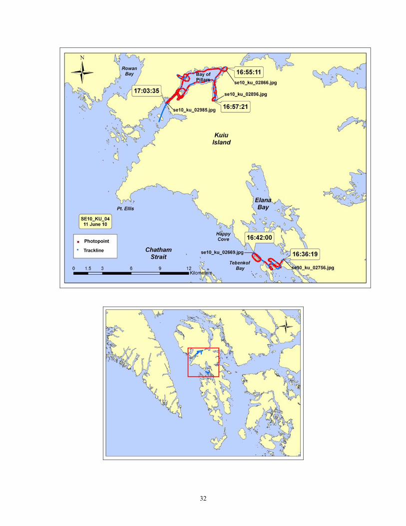
2010 Southeast Alaska Aerial Video Imaging Survey Team Kuiu (KU)
Tape: SE10_KU_04 Date: 11 June 2010 General Location: W Kuiu Island, Tebenkof Bay, Bay of Pillars Time Start (UTC): 16:36:19 Geo: Harper Fuel Break: none Bio: Morris Time End (UTC): 17:03:35 Nav: Daley Tape Length: 19 min 54 sec Pilot: Snider Weather: Overcast, windy
Time (UTC)
Location
Photo
16:36:19 Islands to E of Step Is, Tebenkof Bay se10_ku_02669.jpg 16:42:00 Islands to N of Step Is, Tebenkof Bay se10_ku_02756.jpg Transit 16:42:00 to 16:49:23 16:49:23 Entrance channel to Honeymoon Basin se10_ku_02771.jpg 16:55:11 Head of Honeymoon Basin se10_ku_02866.jpg 16:57:21 Head of S arm in Honeymoon Basin se10_ku_02896.jpg 17:03:35 Entrance to Honeymoon Basin se10_ku_02985.jpg

34

35
2010 Southeast Alaska Aerial Video Imaging Survey Team Kuiu (KU)
Tape: SE10_KU_05 Date: 12 June 2010 General Location: W Kuiu Island Time Start (UTC): 13:53:26 Geo: Daley Fuel Break: None Bio: Morris Time End (UTC): 14:48:45 Nav: Harper Tape Length: 55min 19 sec Pilot: Snider Weather: Overcast, rainy, very windy
Time (UTC)
Location
Photo
13:53:25 N tip of Step Is in Tebenkof Bay se10_ku_02989.jpg 14:17:22 S tip of East Is in Tebenkof Bay se10_ku_03251.jpg 14:20:20 Mouth of Petrof Bay se10_ku_03286.jpg 14:24:54 S end of Petrof Bay se10_ku_03346.jpg 14:46:09 Lisa Pt in Tebenkof Bay se10_ku_03567.jpg 14:48:45 Orel Anchorage se10_ku_03594.jpg Note: There was a problem with the HD camera tape, which actually started at 10 minutes into the tape and there is approximately 1 minute missing from the end of the tape (taped ended at 1 hr 5 min). The DV tape is complete.

36

37
2010 Southeast Alaska Aerial Video Imaging Survey Team Kuiu (KU)
Tape: SE10_KU_06 Date: 12 June 2010 General Location: W Kuiu Island Time Start (UTC): 14:51:08 Geo: Daley Fuel Break: None Bio: Morris Time End (UTC): 15:36:04 Nav: Harper Tape Length: 42 min 56 sec Pilot: Snider Weather: Overcast, rainy, very windy
Time (UTC)
Location
Photo
14:51:08 Orel Anchorage, Tebenkof Bay se10_ku_03596.jpg 15:04:43 Oyster Rock, Thetis Bay se10_ku_03764.jpg 15:07:52 E mouth of Helianthus Passage se10_ku_03800.jpg 15:17:11 Troller Pt, N end of Troller Islands se10_ku_03936.jpg 15:24:51 SW end of Windfall Islands se10_ku_04036.jpg 15:31:51 SE corner of Explorer Basin se10_ku_04118.jpg 15:36:04 Swaine Pt, Explorer Basin se10_ku_04182.jpg

38

39
2010 Southeast Alaska Aerial Video Imaging Survey Team Kuiu (KU)
Tape: SE10_KU_07 Date: 12 June 2010 General Location: W Kuiu Island Time Start (UTC): 16:06:40 Geo: Harper Fuel Break: None Bio: Morris Time End (UTC): 17:05:16 Nav: Daley Tape Length: 58 min 36 sec Pilot: Snider Weather: Overcast, rainy, very windy
Time (UTC)
Location
Photo
16:06:40 Swaine Pt, Explorer Basin se10_ku_04187.jpg 16:12:28 N entrance to Gedney Harbor se10_ku_04279.jpg 16:20:50 S entrance to Gedney Harbor se10_ku_04394.jpg 16:22:41 Pt Cosmos se10_ku_04425.jpg 16:28:13 Harris Cove se10_ku_04507.jpg 16:32:11 Cape Harris, Port Malmesbury se10_ku_04565.jpg 16:44:00 Head of SE arm, Port Malmesbury se10_ku_04714.jpg 16:53:50 Head of SW arm, Port Malmesbury se10_ku_04815.jpg 17:05:16 N of entrances to Table Bay se10_ku_04975.jpg

40

41
2010 Southeast Alaska Aerial Video Imaging Survey Team Kuiu (KU)
Tape: SE10_KU_08 Date: 12 June 2010 General Location: W Kuiu Island Time Start (UTC): 17:06:15 Geo: Harper Fuel Break: None Bio: Morris Time End (UTC): 17:19:09 Nav: Daley Tape Length: 12 min 56 sec Pilot: Snider Weather: Overcast, rainy, very, very windy (+30 knots)
Time (UTC)
Location
Photo
17:06:15 N of entrances to Table Bay se10_ku_04981.jpg 17:09:21 Head of NW arm of Table Bay se10_ku_05022.jpg 17:14:46 Head of NE arm of Table Bay se10_ku_05090.jpg 17:16:19 Head of SE are of Table Bay se10_ku_05123.jpg 17:19:09 Approx 1 km N of Cape Crowley se10_ku_05177.jpg Note: Survey terminated due to turbulence

42

43
2010 Southeast Alaska Aerial Video Imaging Survey Team Kuiu (KU)
Tape: SE10_KU_09 Date: 13 June 2010 General Location: E Kuiu Island Time Start (UTC): 13:52:49 Geo: Harper Fuel Break: None Bio: Morris Time End (UTC): 14:50:21 Nav: Daley Tape Length: 58 min 39 sec Pilot: Snider Weather: Overcast, rainy, windy
Time (UTC)
Location
Photo
13:52:49 N entrance to Alvin Bay se10_ku_05181.jpg 13:57:45 S tip of Summer Is se10_ku_05240.jpg Transit to Strait and Mariposa Is 14:01 to
14:03:12
14:05:23 S tip of Mariposa Is se10_ku_05334.jpg Transit back to Summer Is 14:07:58 to 14:09:00 14:32:59 S tip of Conclusion Is se10_ku_05738.jpg 14:38:40 S entrance of No Name Bay se10_ku_05802.jpg 14:50:12 Head of No Name Bay se10_ku_05948.jpg

44

45
2010 Southeast Alaska Aerial Video Imaging Survey Team Kuiu (KU)
Tape: SE10_KU_10 Date: 13 June 2010 General Location: E Kuiu Island Time Start (UTC): 14:51:30 Geo: Harper Fuel Break: None Bio: Morris Time End (UTC): 15:42:36 Nav: Daley Tape Length: 51 min 06 sec Pilot: Snider Weather: Overcast, rainy, windy
Time (UTC)
Location
Photo
14:51:30 Head of No Name Bay se10_ku_05949.jpg 15:03:28 N entrances to No Name Bay se10_ku_06124.jpg 15:16:57 Entrance to tidal lagoon, Seclusion Harbor se10_ku_06339.jpg 15:26:00 Island at entrances to Threemile Arm se10_ku_06505.jpg 15:35:19 Head of Threemile Arm se10_ku_06654.jpg 15:42:36 E entrance of Threemile Arm se10_ku_06783.jpg

46

47
2010 Southeast Alaska Aerial Video Imaging Survey Team Kuiu (KU)
Tape: SE10_KU_11 Date: 13 June 2010 General Location: E Kuiu Island, Rocky Pass Time Start (UTC): 16:21:31 Geo: Daley Fuel Break: None Bio: Morris Time End (UTC): 17:18:14 Nav: Harper Tape Length: 58 min 16 sec Pilot: Snider Weather: Overcast, rainy, windy
Time (UTC)
Location
Photo
16:21:31 Island group at S entrance to Rock Pass se10_ku_06831.jpg Transit to Kupreanof: 16:30:16 to 16:33:02 16:33:03 Kupreanof Is near Skip Is se10_ku_07011.jpg Transit from Kupreanof to island: 16:37:32 to
16:38:41
16:38:42 Island between entrances to Threemile Arm and Rocky Pass
se10_ku_07100.jpg
Transit from island to entrance of No Name Bay: 16:40:29 to 16:43:33
16:43:34 E entrance to Threemile Arm se10_ku_07164.jpg 16:55:30 W entrance to Rocky Pass se10_ku_07333.jpg 17:10:45 S of narrows at Summit in Rocky Pass se10_ku_07577.jpg 17:18:14 Rocky Pass, just north of Summit se10_ku_07717.jpg

48

49
2010 Southeast Alaska Aerial Video Imaging Survey Team Kuiu (KU)
Tape: SE10_KU_12 Date: 13 June 2010 General Location: E Kuiu Island Time Start (UTC): 17:19:17 Geo: Daley Fuel Break: None Bio: Morris Time End (UTC): 18:02:44 Nav: Harper Tape Length: 24 min 54 sec Pilot: Snider Weather: Overcast, rainy, windy
Time (UTC)
Location
Photo
17:19:17 Mid Rock Pass at the Summit se10_ku_07720.jpg Transit from Rocky Pass to Port Camden
17:21:23 to 17:26:38
17:34:46 Head of Camden Bay se10_ku_07877.jpg Transit from Port Camden to Alvin Bay
17:38:06 to 17:52:37
17:52:38 Pt north of Reid Bay se10_ku_07960.jpg 17:55:04 S entrance to Alvin Bay se10_ku_07999.jpg 17:57:00 Head of Alvin Bay se10_ku_08034.jpg 18:02:44 N entrance to Alvin Bay se10_ku_08125.jpg

50

51
2010 Southeast Alaska Aerial Video Imaging Survey Team Kuiu (KU)
Tape: SE10_KU_13 Date: 14 June 2010 General Location: S Kuiu Island Time Start (UTC): 14:41:28 Geo: Harper Fuel Break: None Bio: Morris Time End (UTC): 15:39:40 Nav: Daley Tape Length: 59 min 33 sec Pilot: Snider Weather: Sunny, calm
Time (UTC)
Location
Photo
14:41:48 S shore of Table Bay se10_ku_08143.jpg 14:45:21 Pt Crowley se10_ku_08211.jpg 14:49:51 Pt Howard se10_ku_08301.jpg 14:58:54 Cape Decision se10_ku_08503.jpg 15:06:47 Fairway Is se10_ku_08635.jpg 15:08:25 S entrance to Port McArthur se10_ku_08656.jpg 15:21:04 S entrance to Kell Bay se10_ku_08919.jpg 15:25:31 Head of Kadey Krogen Cove se10_ku_09000.jpg 15:39:40 Head of NW arm, Kell Bay se10_ku_09255.jpg

52

53
2010 Southeast Alaska Aerial Video Imaging Survey Team Kuiu (KU)
Tape: SE10_KU_14 Date: 14 June 2010 General Location: SE Kuiu Island Time Start (UTC): 15:40:28 Geo: Harper Fuel Break: None Bio: Morris Time End (UTC): 16:26:28 Nav: Daley Tape Length: 47 min 01 sec Pilot: Snider Weather: Sunny, calm
Time (UTC)
Location
Photo
15:40:28 Head of NW arm, Kell Bay se10_ku_09256.jpg 15:51:04 N entrance to Kell Bay se10_ku_09405.jpg 15:58:30 S entrance to Bear Harbor se10_ku_09541.jpg 16:04:53 Head of Bear Harbor se10_ku_09627.jpg 16:20:21 Head of Affleck Canal se10_ku_09845.jpg 16:26:28 East shore of Affleck Canal, opposite of Bear
Harbor se10_ku_09929.jpg

54

55
2010 Southeast Alaska Aerial Video Imaging Survey Team Kuiu (KU)
Tape: SE10_KU_15 Date: 14 June 2010 General Location: SE Kuiu Island Time Start (UTC): 16:59:48 Geo: Daley Fuel Break: None Bio: Morris Time End (UTC): 17:55:51 Nav: Harper Tape Length: 57 min 09 sec Pilot: Snider Weather: Sunny, calm
Time (UTC)
Location
Photo
16:59:48 East shore of Affleck Canal, opposite of Bear Harbor
se10_ku_09931.jpg
17:06:58 Head of cove opposite of Kell Bay se10_ku_10042.jpg 17:16:11 Pt St Albans se10_ku_10177.jpg 17:31:22 S entrance to Louise Cove se10_ku_10431.jpg 17:39:53 Amelius Is se10_ku_10587.jpg 17:43:02 Pt Amelius se10_ku_10633.jpg 17:50:45 Beauclerc Is se10_ku_10738.jpg 17:55:51 Beauclerc Bay, just south of Edwards Is se10_ku_10803.jpg

56

57
2010 Southeast Alaska Aerial Video Imaging Survey Team Kuiu (KU)
Tape: SE10_KU_16 Date: 14 June 2010 General Location: SE Kuiu Island Time Start (UTC): 17:57:23 Geo: Daley Fuel Break: None Bio: Morris Time End (UTC): 18:35:28 Nav: Harper Tape Length: 38 min 05 sec Pilot: Snider Weather: Sunny, calm
Time (UTC)
Location
Photo
17:57:23 Beauclerc Bay, just south of Edwards Is se10_ku_10808.jpg 18:00:44 N tip of Edwards Is se10_ku_10868.jpg 18:08:47 S arm of Port Beauclerc se10_ku_10981.jpg 18:26:13 Head of Port Beauclerc se10_ku_11235.jpg 18:35:28 SE entrance to Beauclerc Bay se10_ku_11363.jpg

58

59
2010 Southeast Alaska Aerial Video Imaging Survey Team Kuiu (KU)
Tape: SE10_KU_17 Date: 15 June 2010 General Location: Spanish and Coronation Islands Time Start (UTC): 15:33:39 Geo: Harper Fuel Break: None Bio: Morris Time End (UTC): 16:19:29 Nav: Daley Tape Length: 46 min 10 sec Pilot: Snider Weather: Sunny, windy
Time (UTC)
Location
Photo
15:33:39 S side of northern-most Spanish Is se10_ku_11411.jpg 15:42:32 N tip of Coronation Is se10_ku_11549.jpg 15:48:41 W arm of Aats Bay, Coronation Is se10_ku_11657.jpg 15:51:43 Large sea lion colony Alikula Bay se10_ku_11716.jpg 15:57:23 Nation Pt, Coronation Is se10_ku_11837.jpg 16:01:38 Head of Windy Bay on a windy day se10_ku_11922.jpg 16:06:27 Helm Pt, southern-most tip of Coronation Is se10_ku_12035.jpg 16:12:03 Cora Is, Coronation Is se10_ku_12119.jpg 16:17:23 Halfway up E side of Spanish Is se10_ku_12229.jpg 16:19:29 N tip of Spanish Islands se10_ku_12257.jpg Note: Extremely turbulent on the south side of Coronation Island so imagery is
very high, distant and jumpy

60

61
2010 Southeast Alaska Aerial Video Imaging Survey Team Kuiu (KU)
Tape: SE10_KU_18 Date: 15 June 2010 General Location: Warren Is, S Kosciusko Is Time Start (UTC): 16:58:13 Geo: Daley Fuel Break: None Bio: Morris Time End (UTC): 17:58:11 Nav: Harper Tape Length: 58 min 47 sec Pilot: Snider Weather: Sunny, windy
Time (UTC)
Location
Photo
16:58:13 N tip of Warren Is se10_ku_12261.jpg 17:02:54 W tip of Warren Is (California mussels) se10_ku_12346.jpg 17:05:24 Boot Pt, SW corner of Warren Is se10_ku_12402.jpg 17:09:01 Center of Warren Cove, Warren Is se10_ku_12493.jpg 17:13:44 N tip of Warren Is, finish se10_ku_12596.jpg Transit 17:16:50 Pt Hardscrabble, S Kosciusko Is se10_ku_12616.jpg 17:19:24 head of Cape Pole community se10_ku_12668.jpg 17:25:55 W entrance to Halibut Harbor se10_ku_12811.jpg 17:29:46 Island just E of Quartz Rock se10_ku_12896.jpg 17:34:55 Head of Survey Cove se10_ku_12986.jpg 17:44:24 Island at W entrance to Fake Pass se10_ku_13171.jpg 17:50:53 S tip of Whale Head Is se10_ku_13294.jpg 17:58:11 Round Is, western Sea Otter Sound se10_ku_13437.jpg

62

63
2010 Southeast Alaska Aerial Video Imaging Survey Team Kuiu (KU)
Tape: SE10_KU_19 Date: 15 June 2010 General Location: S Kosciusko Island Time Start (UTC): 17:59:07 Geo: Daley Fuel Break: None Bio: Morris Time End (UTC): 18:09:02 Nav: Harper Tape Length: 10 min 55 sec Pilot: Snider Weather: Sunny, windy
Time (UTC)
Location
Photo
17:59:07 E entrance to Straw Pass, Kosciusko Is se10_ku_13438.jpg 18:00:03 E entrance to Straw Pass se10_ku_13446.jpg 18:06:26 S tip of Green Is se10_ku_13577.jpg 18:09:02 Point near Entrance Is, Edna Bay se10_ku_13631.jpg

64

65
2010 Southeast Alaska Aerial Video Imaging Survey Team Kuiu (KU)
Tape: SE10_KU_20 Date: 16 June 2010 General Location: E Kuiu Island Time Start (UTC): 17:54:06 Geo: Harper Fuel Break: None Bio: Morris Time End (UTC): 18:17:13 Nav: Daley Tape Length: 23 min 07 sec Pilot: Snider Weather: Low overcast, calm
Time (UTC)
Location
Photo
17:54:06 E entrance to Beauclerc Bay, Kuiu Is se10_ku_13684.jpg 17:59:40 Boulder Pt, S of Reid Bay se10_ku_13793.jpg 18:04:04 Island at W entrance to Reid Bay se10_ku_13885.jpg 18:12:04 Head of Reid Bay, Kuiu Is se10_ku_14029.jpg 18:17:13 E entrance to Alvin Bay, Kuiu Is se10_ku_14118.jpg Note: Last survey to complete all shoreline imaging in SE Alaska

66

67
SE10 AVI Team Humpback Example Photos, Survey Day 1 May 27, 2010 George Islands, Inian Islands, Lemesurier Island and The Sisters in Icy Strait. Islands surrounded by glacial silty water, bright aquamarine in color. Dominated by Dragon Kelp (ALF) in the nearshore subtidal.
Steep bedrock cliffs, George Islands, Icy Strait se10_hb_00572.jpg
White pollen from trees on the surface of the water, Inian Islands, Icy Strait se10_hb_00823.jpg
Large bed of Dragon Kelp (ALF) streaming in the current, Lemesurier Island, Icy Strait se10_hb_00912.jpg
Wide beach with Dragon Kelp (ALF) and Eelgrass (ZOS) in the subtidal, Lemesurier Island, Icy Strait se10_hb_00967.jpg

68
SE10 AVI Team Humpback Example Photos, Survey Day 2 May 28, 2010 Frederick Sound from Cape Fanshaw to Icy Cove, including Farragut Bay and Thomas Bay. Area has extensive estuaries with wide tidal flats. Blue Mussels (BMU) form distinct dark bands on bedrock cliffs and large patches on tidal flats. Glacial silty water.
Black patches of Blue Mussel (BMU) on edge of tidal Farragut River estuary, Farragut Bay se10_hb_01466.jpg
Large estuarine complex, southeast of Agassiz Point, Frederick Sound se10_hb_01884.jpg
Steep narrow bedrock cliff, northeast of Porter Cove, Thomas Bay se10_hb_02119.jpg
Baird Glacier, Thomas Bay se10_hb_02136.jpg

69
SE10 AVI Team Humpback Example Photos, Survey Day 3 May 29, 2010 Northwest Kuiu Island from Gil Harbour to Kingsmill Point, including Hound Island, Keku Islands, Saginaw Bay and Security Bay. Diversity of wave energies, shoreline habitats and substrate types.
Low wave cut platform with a veneer of fine sediment, Gil Harbour, Kuiu Island se10_hb_02891.jpg
Sand spit formation due to longshore drift, east Keku Islands se10_hb_02995.jpg
Sand beach mixed with rock ramp including backshore sediment deposits, southeast Saginaw Bay, Kuiu Island se10_hb_03806.jpg
Continuous banding of algae along limestone shoreline, west of Saginaw Bay, Kuiu Island se10_hb_04212.jpg

70
SE10 AVI Team Kuiu Example Photos, Survey Day 1 June 11, 2010 Kingsmill Point, northwest Kuiu Island south to Elena Bay, in Tebenkof Bay, Kuiu Island, including Rowan Bay, Bay of Pillars and the upper lagoon with current dominated channel at the head of Bay of Pillars. The region is notable for the extensive Dragon Kelp (ALF) on the open coast facing Chatham Strait, the complex of islets and lagoons at the entrances of Rowan Bay and Bay of Pillars, ruins of old cannery sites in Washington Bay and Bay of Pillars, and the broad estuary flats at heads of all of the larger inlets.
Estuary at the head of Rowan Bay, northwest Kuiu Island se10_ku_00736.jpg
Islets and rock ramps with abundant Dragon Kelp (ALF), outside Bay of Pillars, west Kuiu Island se10_ku_01057.jpg
Ruins of cannery site, Bay of Pillars, west Kuiu Island se10_ku_01484.jpg
Estuary salt marsh zonation, Elena Bay, upper Tebenkof Bay, west Kuiu Island se10_ku_02893.jpg

71
SE10 AVI Team Kuiu Example Photos, Survey Day 2 June 12, 2010 South Tebenkof Bay from Petro Bay complex, outer west coast of Kuiu Island, south to Port Malmsbury, Table Bay to just north of Point Crowley, where we are stopped by rough winds and turbulence. Exciting area of complex reefs and islets on open west coast, with several examples of overlapping three species of canopy kelps (ALF, MAC, NER). Diversity of wave energies, from sheltered inlets to open west coast.
Islet in Petrof Bay, Tebenkof Bay, mid-west side Kuiu Island se10_ku_03066.jpg
High energy platform at Point Harris, southwest Kuiu Island se10_ku_04569.jpg
Islet and Giant Kelp (MAC), upper Port Malmesbury, southwest Kuiu Island se10_ku_04739.jpg
Looking south along Kuiu Island, from north of Table Bay se10_ku_04955.jpg

72
SE10 AVI Team Kuiu Example Photos, Survey Day 3 June 13, 2010 East side of Kuiu Island, from Sumner Island, Strait Island, north through No Name Bay, Threemile Arm, southwest Rocky Pass, and closed gaps at south Port Camden as well as southwest corner of Kupreanof Island. Mostly shelter inlets and bays, on east-facing shore of Kuiu Island, with highlights including the complex salt lagoon in upper Seclusion Harbor, fish traps and canoe runs in Rocky Pass and Port Camden, and areas of extensive Ruppia flats in Rocky Pass.
Sea otters in Dragon Kelp (ALF), east Kuiu Island se10_ku_05729.jpg
Platforms near entrance to No Name Bay, east Kuiu Island se10_ku_06274.jpg
Outflow tidal Salt Lagoon at head of Seclusion Harbor se10_ku_06337.jpg
Flats and islets, Rocky Pass, between Kuiu Island and Kupreanof Islands se10_ku_07703.jpg

73
SE10 AVI Team Kuiu Example Photos, Survey Day 4 June 14, 2010 Resume at exposed south entrance to Table Bay, on southwest Kuiu Island, round Cape Decision, north up the east side Kuiu through Kell Bay, Affleck Canal, round Point Albans and complete Port Beauclerc, lower east side of Kuiu Island. Daily highlights included completing the open high energy exposed west coast at Cape Crowley and rounding Cape Decision to more shelter on east coast. Many locations with all three canopy kelps (ALF, MAC, NER) co-existing.
Cape Decision lighthouse, south tip of Kuiu Island se10_ku_08509.jpg
Islet with eelgrass (ZOS), Bear Harbor, upper Affleck Bay, south Kuiu Island se10_ku_09585.jpg
View southeast across Sumner Strait, from Port Beauclerc entrance, Prince of Wales Island on the horizon se10_ku_10744.jpg
Estuary in upper Beauclerc Bay, southeast Kuiu Island se10_ku_11057.jpg

74
SE10 AVI Team Kuiu Example Photos, Survey Day 5 June 15, 2010 From Port McArthur, Kuiu Island, survey at Spanish Islands southward on to Coronation Island, along extremely rough downdraft winds on south coast. Cross to Warren Island and the section of Kosciusko Island from Cape Pole to Edna Bay. Extremely rugged coast at Coronation Island with Very Exposed vertical limestone cliffs at Helm Point. Areas of California Mussel (MUS) bioband with gooseneck barnacles at Coronation Island, as well as at south Warren Island. Complex and lush platform lagoon complexes with Eelgrass and Surfgrass, lush biota at Halibut Harbor. Survey the southernmost extent of Dragon Kelp (ALF).
Very Exposed cliffs, southwest Coronation Island se10_ku_12032.jpg
Gooseneck barnacle and California Mussel (MUS) band, south Warren Island se10_ku_12377.jpg
Humpback whale and calf, nearshore along the east side of Warren Island se10_ku_12464.jpg
Islets and Macrocystis (MAC) in Halibut Harbor, southwest Kosciusko Island se10_ku_12904.jpg

75
SE10 AVI Team Kuiu Example Photos, Survey Day 6 June 16, 2010 Short section of coast on east side of Kuiu Island, from north entrance Beauclerc Bay to north side of Reid Bay. Semi-Protected and Protected bays on east side of Kuiu Island. Notable for lush Soft Brown Kelps (SBR).
Lush lower intertidal on platforms, near Boulder Point, southeast Kuiu Island se10_ku_13813.jpg
Thick Soft Brown Kelps (SBR), including clumps of Cymathere, with nearshore Dragon Kelp (ALF), near Boulder Point, southeast Kuiu Island se10_ku_13818.jpg
Small saltmarsh and mobile beach face, upper Reid Bay, east Kuiu Island se10_ku_13987.jpg
Islet at north entrance to Reid Bay, east Kuiu Island se10_ku_14086.jpg

76
References Harney, J.N., Morris, M., and Harper, J.R. 2008. ShoreZone Coastal Habitat Mapping Protocol for the Gulf of Alaska. Report prepared for The Nature Conservancy, NOAA National Marine Fisheries Service, and the Alaska State Department of Natural Resources (Juneau, AK). 153 p. Acknowledgments The ShoreZone program is a partnership of scientists, GIS specialists, web specialists, non-profit organizations, and governmental agencies. We gratefully acknowledge the support of organizations working in partnership for the Alaska ShoreZone effort, including:
• Alaska Department of Fish and Game • Alaska Department of Natural Resources • Archipelago Marine Research Ltd. • Coastal and Ocean Resources Inc. • Cook Inlet Regional Citizens’ Advisory Council • Exxon Valdez Oil Spill Trustee Council • NOAA National Marine Fisheries Service • Prince William Sound Regional Citizens’ Advisory Council • The Nature Conservancy • University of Alaska • U.S. Forest Service • U.S. Fish and Wildlife Service • U.S. National Park Service
We also thank the staff of Coastal and Ocean Resources Inc. and Archipelago Marine Research Ltd. for their efforts in the field and in the office. Access and Use Constraints Protocols for data access and distribution are established by the program partner agencies. Please see www.coastalandoceans.com for a list of partner agencies and related web sites. Video imagery can be viewed and digital stills downloaded online at www.alaskafisheries.noaa.gov/maps/szintro.htm. Any hardcopies or published data sets utilizing ShoreZone products shall clearly indicate their source. To ensure distribution of the most current public information or for correct interpretation, contact the ShoreZone project manager at Coastal and Ocean Resources, Inc. At the time of publication, that person is Dr. John Harper. To effectively and appropriately use ShoreZone data, the user shall refer to the ShoreZone Coastal Habitat Mapping Protocol (2008) available at www.coastalandoceans.com. Data provided are derived from large, regional databases that are continually being updated and modified. The accuracy of some information is subject to change. Any published data sets utilizing ShoreZone products (printed, digital, or online) shall clearly indicate their source. If the user has modified the data in any way, the user is obligated to describe the types of modifications performed. The user specifically agrees not to misrepresent these data, nor to imply that changes made were approved by the ShoreZone program or its partners.

77