Embed Size (px)
Citation preview
FO-200.18
Statewide Trout, Salmon, Whitefish, Lake Herring, and Smelt Regulations By authority conferred on the Natural Resources Commission and the Department of Natural Resources by Part 487 of 1994 PA 451, MCL 324.48701 to 324.48740, it is ordered on November 9, 2017, the following section(s) of the Fisheries Order shall read as follows: The following regulations are established for trout, salmon, whitefish, lake herring, and smelt:
LAKE TROUT MANAGEMENT UNITS – Great Lakes
Lake Michigan
MM-1 is bounded on the southeast and south by the Michigan-Wisconsin boundary in Green Bay and on the east by a north-south line beginning near Fairport in Delta County at Longitude 08640'W and extending south to the Wisconsin-Michigan border.
MM-2 is bounded on the west by MM-1, on the east by a north-south line beginning about 4 miles west of Seul Choix Point in Schoolcraft County at Longitude 08600'W and extending southward to Latitude 4520'N, and on the south by an east-west line at Latitude 4520'N that extends west from Longitude 08600'W to the Michigan-Wisconsin boundary.
MM-3 is bounded on the west by a north-south line from the shore about 4 miles west of Seul Choix Point in Schoolcraft County at Longitude 8600'W and extending southward to its intersection with Latitude 4510' N, on the east by the Mackinac Bridge, and on the south by an east-west line from Longitude 08600'W at Latitude 4510' N and extending eastward to the shore about 4 miles north of Eastport in Antrim County.
MM-4 includes all waters of Grand Traverse Bay south of Latitude 4510'N.
MM-5 is bounded on the west by the Michigan-Wisconsin boundary, on the north by an east-west line beginning on the Michigan-Wisconsin boundary at Latitude 4520'N and extending eastward along said latitude to Longitude 08600'W, then southward along said longitude to Latitude 4510'N, then eastward along said latitude to its intersection with the west shore of Leelanau County, and on the south by an east-west line beginning near Arcadia in Manistee County at Latitude 4430'N and extending west to the Michigan-Wisconsin boundary.
MM-6 is bounded on the west by the Michigan-Wisconsin boundary, on the north by MM-5, and on the south by an east-west line from Little Sable Point in Oceana County at Latitude 4340'N and extending westward to the Michigan-Wisconsin boundary.
MM-7 is bounded on the west by the Michigan-Wisconsin boundary, on the north by MM-6, and on the south by an east-west line from the Michigan shore about 4 miles north of Holland in Ottawa County at Latitude 4250'N and extending westward to the Michigan-Wisconsin boundary.
MM-8 is bounded on the west by the Michigan-Wisconsin boundary and the Michigan-Illinois boundary, on the north by MM-7, and on the south by the Michigan-Indiana boundary.
Lake Huron
MH-1 is bounded on the west by the Mackinac Bridge, on the north by an east west line from the village of Detour in Chippewa County at Latitude 4600'N to the west shore of Drummond Island and an east-west line from the east shore of Drummond Island at Latitude 4600'N to the international boundary, and on the east and south by a line beginning where Longitude 08330'W intersects the international boundary near Drummond Island in Chippewa County and extending southward along said longitude to Latitude 4530'N, then extending westward along said latitude to Longitude 08340'W, then extending southward along said longitude to shore about 3.5 miles southeast of Adams Point in Presque Isle County.
MH-2 is bounded on the north by MH-1, on the east by the international boundary, and on the south by an east-west line extending from the shore about one mile north of Black River in Alcona County at Latitude 4450'N and extending eastward along said latitude to the International boundary.
MH-3 is bounded on the north by MH-2, on the east by the international boundary, and on the south by a line beginning on the shore on Au Sable Point in Iosco County at Latitude 4420'N and extending eastward along said latitude to Longitude 08310'W, then southward along said longitude to Latitude 4410'N, then eastward along said latitude to the international boundary.
MH-4 is bounded on the north by MH-3 and on the east by a north-south line beginning on the shore about 2.6 miles southeast of Point aux Barques light in Huron County at Latitude 4400'N and extending eastward along said latitude to Longitude 08240'W, then northward along said longitude to the southern boundary with MH-3 at Latitude 4410'N.
MH-5 is bounded on the west by MH-4, on the north MH-3, on the east by the international boundary, and on the south by an east-west line beginning on the shore in the village of Forester in Sanilac County at Latitude 4330'N and extending eastward along said latitude to the international boundary.
MH-6 is bounded on the north by MH-5, on the east by the international boundary, and on the south by the Blue Water Bridge in St. Clair County at Latitude 4300'N.
Lake Superior
MI-1 is bounded on the west by the Michigan-Minnesota boundary, on the north by the international boundary, and on the south by a line beginning on the Minnesota boundary at Latitude 4740'N extending eastward along said latitude to Longitude 08830'W then northward along said longitude to Latitude 4750'N then eastward along said latitude to Longitude 08800'W then northward along said longitude to Latitude 4800'N then eastward along said latitude to the international boundary.
MI-2 is bounded on the west by the Michigan-Minnesota and the Michigan-Wisconsin boundaries, on the north by MI-1, and on the east by a north-south line extending from the shore about 2.6 miles southwest of Fourteen Mile Point in Ontonagon County northward at Longitude 08910'W to the southern border of MI-1 at Latitude 4740'N.
MI-3 is bounded on the west by MI-2, on the north by MI-1, and on the east by a line extending northward from the shore about 1.4 miles east of Copper Harbor in Keweenaw County at Longitude 08750'W to Latitude 4730'N then eastward along said latitude to Longitude 08740'W then northward along said longitude to the international border.
MI-4 is bounded on the west by MI-3, on the north by the international boundary, and on the southeast and east by a line beginning on the shore at Pine River Point in Marquette County at Longitude 08750'W and extending northward along said longitude to Latitude 4700'N then eastward along said latitude to Longitude 08730'W then northward along said longitude to Latitude 4710'N then eastward along said latitude to Longitude 08720'W then northward along said longitude to Latitude 4720'N then eastward along said latitude to Longitude 08700'W then northward to the international boundary.
MI-5 is bounded on the west and north by MI-4 and on the east by a north-south line beginning on Laughing Fish Point in Alger County at Longitude 08700'W and extending northward to Latitude 4720'N.
MI-6 is bounded on the west by MI-4 and MI-5, on the north by the international boundary, and on the east by a north-south line beginning on Au Sable Point in Alger County at Longitude 08610'W and extending northward to the international boundary.
MI-7 is bounded on the west by MI-6, on the north by the international boundary, and on the east by a north-south line beginning about four miles east of Crisp Point in Luce County at Longitude 08520'W and extending northward to the international boundary
MI-8 is bounded on the west by MI-7, on the north and east by the international boundary with the easternmost border formed by a line from Brush Point in Chippewa County to Point aux Pins Ontario in the upper St. Marys River.
SECTION I. Seasons--General
Except as otherwise noted in the following sections of this Order, the fishing and possession seasons on non-designated trout streams and all other inland waters, the Saginaw River, and the Great Lakes and connecting waters are open for the entire year for all trout, salmon, whitefish, and Lake Herring.
Exceptions to the general possession season:
1) The possession season for Lake Trout and Splake shall be January 1 - September 30 in MM-1 through MM-5 in Lake Michigan.
2) The possession season for Lake Trout and Splake shall be open for the entire year in MM-6 through MM-8 in Lake Michigan.
3) The possession season for Lake Trout and Splake shall be January 1 - September 30 in MH-1 and MH-2 in Lake Huron.
4) The possession season for Lake Trout and Splake shall be open for the entire year in MH-3 through MH-6 in Lake Huron.
SECTION II. Lake Whitefish and Lake Herring
Size and daily possession limits for Lake Whitefish and Lake Herring
On all waters, there is no minimum size limit for Lake Whitefish (Coregonus clupeaformis) or Lake Herring (Coregonus artedi). The daily possession limit shall be twelve (12) fish in any combination, except the daily possession limit shall be five (5) fish in any combination on Chicagon Lake and Lake Ottawa (Iron County).
SECTION III. Rainbow Smelt
Size, daily possession limits, season, and gear for Rainbow Smelt
On all waters, there is no minimum size limit for Rainbow Smelt (Osmerus mordax). The daily harvest/possession limit for smelt on all waters of the state shall be 2 gallons. The harvest season is open all year for hook-and-line. See FO-219 for spear, bow and arrow, or crossbow seasons and FO-229 for netting seasons.
SECTION IV. Arctic Grayling
Size, daily possession limits, season, and gear for Arctic Grayling
A person shall not at any time take, attempt to take, or possess any Arctic Grayling (Thymallus tricolor) taken from any waters over which this state has jurisdiction.
SECTION V. Trout and Salmon—Great Lakes and Connecting Waters
Size limits
Minimum size limit shall be 10 inches for all species of trout and salmon, except as follows:
1) Brook Trout
Lake Superior a) MI-1 through MI-8: the minimum size limit for Brook Trout shall be 20 inches.
2) Lake Trout
Lake Michigan a) MM-1 through MM-8: the minimum size limit shall be 15 inches.
Lake Huron a) MH-1 through MH-6: The minimum size limit shall be 15 inches.
Lake Superior a) MI-1 through MI-8: The minimum size limit shall be 15 inches, except that the daily
possession limit shall not include more than one (1) Lake Trout 34 inches or greater.
3) Splake
Lake Michigan a) MM-1 through MM-8: the minimum size limit shall be 15 inches.
Lake Huron a) MH-1 through MH-6: The minimum size limit shall be 15 inches.
Lake Superior a) MI-1 through MI-8: The minimum size limit shall be 15 inches.
Daily possession limit
Five (5) trout and salmon in any combination, except that the daily possession limit shall not include more than three (3) Brook Trout, Brown Trout, Rainbow Trout*, Lake Trout, Splake, or Atlantic Salmon. Additional exceptions are:
1) Lake Superior
a) The daily possession limit shall be one (1) Brook Trout, except that the daily possession limit shall be zero (0) for Brook Trout within 4.5 miles of Isle Royale (waters of the Isle Royale National Park).
b) The daily possession limit shall be five (5) Lake Trout in MI-4, MI-5, MI-6, MI-7, and MI-8.
2) St. Marys River
a) The daily possession limit shall be ten (10) Pink Salmon from the last Saturday in April - September 30.
3) Lake Michigan a) The daily possession limit shall be two (2) Lake Trout in management units MM-1, MM-2,
MM-3, MM-4, and MM-5.
*Note: For the purpose of this Order Rainbow Trout refers to both Rainbow Trout and Steelhead.
SECTION VI: Trout and Salmon in Inland Lakes
On those inland lakes designated below as Types A, B, C, D and E, the minimum size limits for Chinook Salmon, Coho Salmon, Pink Salmon, and Atlantic Salmon shall be as follows:
Species Minimum size limit Chinook Salmon 10 inches Coho Salmon 10 inches Pink Salmon 10 inches Atlantic Salmon 15 inches
Notwithstanding any other Order of the Department, for any inland lake not classified below the fishing and possession seasons are open for the entire year to the taking of trout, the minimum size limit shall be 8 inches, the daily possession limit shall be five (5) trout**, and all types of natural bait and artificial lures may be used.
**Note: The daily possession limit shall not include more than three (3) trout 15 inches or greater.
Type A Lakes
- Fishing season: last Saturday in April - September 30.
- Possession season: last Saturday in April - September 30.
- Tackle: natural baits except minnows (dead or alive) and artificial lures may be used.
- Daily Possession Limit: five (5) trout, except that the daily possession limit shall not include more than three (3) trout 15 inches or greater.
- Size limits:
Species Minimum size limit Brook Trout 10 inches Brown Trout 12 inches Rainbow Trout 12 inches Splake 12 inches Lake Trout 15 inches
Following is a listing of Type A lakes. Type A lakes are managed strictly for trout and, as such, are designated trout lakes.
Type A Designated Trout Lakes
County Lake Name Alger Addis Lakes (T46N, R20W, S33) Alger Bette’s Pond Alger Brian’s Pond Alger Cox Pond (T46N, R19W, S13) Alger Grand Marais Lake Alger Hike Lake Alger Irwin Lake Alger Rock Lake Alger Rock River Pond Alger Sitka Lake (T48N, R13W,S9) Alger Sullivan Lake (T49N, R15W, S21) Alger Trueman Lake Alger West John’s Lake (T48N, R13W, S26) Chippewa Dukes Lake Chippewa Highbanks Lake Chippewa Naomikong Lake Chippewa Naomikong Pond Crawford Bright Lake Crawford Kneff Lake Crawford Shupac Lake Delta Bear Lake Delta Carr Lake (T43N, R18W, S36) Delta Carr Ponds (T43N, R18W, S26) Delta Kilpecker Pond (T43N, R18W, S11) Delta Norway Lake Delta Wintergreen Lake (T43N, R18W, S36) Delta Zigmaul Pond Gogebic Castle Lake Gogebic Cornelia Lake Gogebic Mishike Lake Houghton Penegor Lake Iron Deadman’s Lake (T41N, R32W, S5 & 8) Iron Fortune Pond (T43N, R33W, S25) Iron Killdeer Lake
Type A Designated Trout Lakes
County Lake Name Iron Madelyn Lake Iron Skyline Lake Iron Spree Lake Keweenaw No Name Pond (T57N, R31W, S8) Luce Bennett Springs Lake Luce Brockies Pond (T46N, R11W, S1) Luce Bullhead Lake (T49N, R11W, S34) Luce Dairy Lake Luce Dillingham Lake Luce Holland Lake Luce Jack Lake Luce Little Whorl Lake Luce Pratt Lake Luce Silver Creek Pond Luce Spring Creek Pond Luce Syphon Lake Luce Trout Lake Luce Ward Lake Luce Wolverine Lake Luce Youngs Lake Mackinac Castle Rock Pond Mackinac Millecoquins Pond Marquette Bedspring Lake Marquette Clear Lake Marquette Cranberry Lake (T45N, R30W, S10) Marquette Just Lake Marquette Island Lake (T45N, R30W, S14) Marquette Log Lake Marquette Moccasin Lake Marquette Section 13 Lake Marquette Silver Lake (T46N, R24W, S32) Marquette Slough Lake Marquette Swanzy Lake Oscoda Crater Lake Schoolcraft Kings Pond Schoolcraft Lost Lake Schoolcraft Spring Pond
Type B Lakes
- Fishing season: open for the entire year.
- Possession season: open for the entire year.
- Tackle: all types of natural bait and artificial lures may be used.
- Daily Possession Limit: five (5) trout, except that the daily possession limit shall not include more than three (3) trout 15 inches or greater.
- Size limits:
Species Minimum size limit Brook Trout 10 inches Brown Trout 12 inches Rainbow Trout 12 inches Splake 12 inches Lake Trout 15 inches
Following is a listing of Type B lakes.
Type B Trout Lakes County Lake Name Alcona Reid Lake Alcona South Hoist Lake Alger Ackerman Lake Alger Cheryl’s Pond (T44N, R19W, S25) Alger Kay’s Pond Alger Mirror Lake Alger North (Upper) Shoe Lake (T48N, R17W, S36) Alger Sawaski Pond (T44N, R19W, S14) Antrim Green Lake Baraga Roland Lake Barry Deep Lake Cass Birch Lake Cass Hemlock Lake Charlevoix Louise Lake Cheboygan Silver Lake Cheboygan Twin Lake #1 Cheboygan Weber Lake Emmet, Charlevoix Walloon Lake Gogebic Beatons Lake Gogebic Finger Lake Gogebic Imp Lake Gogebic Little Duck Lake Gogebic Moon Lake Grand Traverse Duck Lake Grand Traverse Green Lake Houghton Emily Lake Houghton Lake on Three Iron Camp Lake (T42N, R35W, S7, 17, 18) Iron Caspian Pond (T42N, R35W, S1) Iron Chicagon Lake Iron Ellen Lake Iron Fortune Lake (T42N, R33W, S4,5) Iron Golden Lake Iron Long Lake Iron Lake Ottawa Kalkaska Bear Lake
Type B Trout Lakes County Lake Name Kalkaska Big Blue Lake Kalkaska North Blue Lake Luce Camp 8 Lake Luce Pretty lake Luce Tank Lake Marquette Bass Lake (T45N, R26W, S29) Marquette Brocky Lake Marquette Cedar Lake (T47N, R27W, S11) Marquette Crooked Lake Marquette Forestville Basin (T48N, R25W, S8) Marquette Little Brocky Lake Marquette Little Shag Lake Marquette Perch Lake (T46N, R29W, S8) Marquette Silver Lake Basin Marquette Squaw Lake Marquette Twin Lake (T45N, R30W, S23) Montmorency Avalon Lake Montmorency Clear Lake Montmorency Lake Fifteen Montmorency McCormick Lake Ogemaw Lake George (T21N, R2E, S18) Ontonagon Courtney Lake Ontonagon Mirror Lake Oscoda Loon Lake Otsego Big Chub Lake Otsego Bridge Lake Otsego Heart Lake Otsego Pickerel Lake Presque Isle Bear Den Lake (T33N, R2E, S32) Schoolcraft Banana Lake Schoolcraft Bear Lake (Nineteen Lake, T44N, R18W, S27)
Type C Lakes
- Fishing season: open for the entire year.
- Possession season: open for the entire year.
- Tackle: all types of natural bait and artificial lures may be used.
- Daily Possession Limit: five (5) trout, except that the daily possession limit shall not include more than three (3) trout 15 inches or greater.
- Size limits:
Species Minimum size limit Brook Trout 8 inches Brown Trout 8 inches Rainbow Trout 8 inches Splake 8 inches Lake Trout 8 inches
Following is a listing of Type C lakes.
Type C Trout Lakes County Lake Name Antrim Bellaire Pond
Type C Trout Lakes County Lake Name Berrien Singer Lake Branch Cary Lake Branch Lake Lavine Cass Harwood Lake Grand Traverse Sand Lake #1 Hillsdale Bear Lake Hillsdale Bird Lake Hillsdale Hemlock Lake Jackson Farwell Lake (T4S, R2W, S25/36) Jackson Swains Lake Kalamazoo Little Paw Paw Lake (T3S, R12W, S31) Kalamazoo Ruppert Lake Kalkaska Big Guernsey Lake Kalkaska Big Twin Lake Kalkaska Starvation Lake Kent Lime Lake Kent Marjella Lake (T10N, R11W, S18) Leelanau Lime Lake Lenawee Allens Lake (T5S, R2E, S10) Lenawee Deep Lake Montcalm Marl Lake Montcalm Nevins Lake Muskegon Half Moon Lake Newaygo Condon Lake Oakland Maceday Lake (T3N, R9E, S7) Ontonagon Trout Creek Pond (T47N, R38W, S14) Osceola Center Lake Presque Isle Trout Creek Pond (T3S, R5E, S17) Van Buren Shafer Lake
Type D Lakes
- Fishing season: last Saturday in April - September 30.
- Possession season: last Saturday in April - September 30.
- Tackle: only artificial lures may be used. It shall be unlawful to use or possess live bait, dead or preserved bait, organic or processed food, or scented material on any of the waters or on shore.
- Daily Possession Limit: one (1) trout.
- Size limits:
Species Minimum size limit Brook Trout 15 inches Brown Trout 15 inches Rainbow Trout 15 inches Splake 15 inches Lake Trout 15 inches
Following is a listing of Type D lakes. Type D lakes are managed for trout and, as such, are designated trout lakes.
Type D Designated Trout Lakes County Lake Name Baraga Lake Alice
Type D Designated Trout Lakes County Lake Name Cheboygan Hemlock Lake (T3N, R1W, S34, 35) Gogebic Redboat Lake Houghton Clear Lake Houghton Perrault Lake Iron Forest Lake Iron Timber Lake Keweenaw Lost Lake Luce Deer Lake Luce Moon Lake Luce Sid Lake Marquette South Kidney Lake (T45N, R26W, S28) Marquette Pauls Lake, North Marquette Pauls Lake, South Marquette Rockingchair Lake, N., (T49N, R28W, S10) Marquette Rockingchair Lake, S., (T49N, R28W, S10) Marquette Strawberry Lake Otsego Ford Lake (T32N, R1W, S8) Otsego Lost Lake Otsego North Twin Lake Otsego Section Four Lake (T32N, R1W, S4) Otsego South Twin Lake Otsego West Lost Lake (T32N, R1W, S3) Schoolcraft Ned’s Lake Schoolcraft Twilight Lake
Type E Lakes
- Fishing season: open for the entire year.
- Possession season: open for the entire year.
- Tackle: all types of natural bait and artificial lures may be used.
- Daily Possession Limit: three (3) trout.
- Size limits:
Species Minimum size limit Brook Trout 15 inches Brown Trout 15 inches Rainbow Trout 15 inches Splake 15 inches Lake Trout 15 inches
Following is a listing of Type E lakes.
Type E Trout Lakes County Lake Name Alger Grand Sable Lake Antrim Torch Lake Antrim, Grand Traverse Elk Lake Barry, Kalamazoo Gull Lake Benzie Crystal Lake Charlevoix Lake Charlevoix Cheboygan Tower Pond (from dam upstream to M-68) Leelanau North Lake Leelanau

Type E Trout Lakes County Lake Name Leelanau Big Glen Lake Luce Belle Lake 1 Luce Peanut Lake Marquette Lake Arfelin Marquette Sporely Lake Roscommon Higgins Lake
Type F Lakes (Drowned River-Mouth Lakes)
NOTE:
1) The following regulations shall apply in each drowned river-mouth lake identified below from the upstream limit of the lake to its mouth at Lake Michigan.
- Fishing season: open for the entire year.
- Possession season: 1) For all species of trout and salmon, open for the entire year.
- Tackle: all types of natural baits and artificial lures may be used.
- Daily Possession Limit: five (5) trout and salmon in any combination, except: 1) Excluding Chinook Salmon and Coho Salmon, the daily possession limit shall not include more than
three (3) of any one species of trout or salmon. 2) The daily possession limit may include up to five (5) Chinook Salmon or Coho Salmon in any
combination.
- Size limits: minimum size limit: 10 inches for all species of trout and salmon.
Following is a listing of Type F lakes.
Type F Trout Lakes County Lake Name Upstream Limit Allegan Kalamazoo Lake/Silver Lake US 31 Benzie Betsie Lake M-22 Manistee Arcadia Lake Inlet of Bowens Creek Manistee Manistee Lake Railroad Bridge below M-55 (T21N, 16W, S6) Manistee Portage Lake Mason Pere Marquette Lake Old 31 Highway Muskegon Duck Lake Nestrom Rd. Muskegon Mona Lake US 31 Muskegon Muskegon Lake M-120 Muskegon White Lake Business Route US 31 Oceana Pentwater Lake Long Bridge Road (B15) Oceana Silver Lake Oceana Stony Lake Inlet of Stony Creek (Scenic Dr., T13N, R18W, S5) Ottawa Lake Macatawa River Ave. Ottawa Pigeon Lake Lakeshore Dr.
SECTION VII. Trout and Salmon on Inland Streams
NOTES:
1) Fisheries Order 210 provides a listing of all designated trout streams in Michigan. Some of the streams listed in FO-210 appear in FO-200 (see section VII) as Types 2, 3, 4 or gear restricted
streams. Type 1 streams are not listed in FO-200. If a stream name appears in FO-210, but not in FO-200 (section VII), then Type 1 stream regulations apply to that stream.
2) Notwithstanding any other Order of the Department, for any inland stream not classified below the fishing and possession seasons are open for the entire year to the taking of trout and salmon, the minimum size limit shall be 8 inches, the daily possession limit shall be five (5) trout and salmon in any combination***, and all types of natural bait and artificial lures may be used.
3) On all waters open to possession, the daily possession limit may include up to five (5) Chinook Salmon or Coho Salmon, in any combination.
4) “Artificial flies” means any commonly accepted single hooked wet and dry flies, streamers, and nymphs without spinner, spoon, scoop, lip or any other fishing lure or bait attached. The fly or leader may be weighted but no weight shall be attached to the fly or to the terminal tackle in a manner that allows the weight to be suspended from or below the hook.
5) “Chumming” means luring or attracting or attempting to lure or attract fish by scattering organic material into the water.
6) Chumming with organic materials shall be prohibited on all Type 1, 2, 3, and 4 streams.
7) On stream Types 1 through 4, size limits for Brook Trout and Brown Trout vary by stream type and may be found in the regulation section for each stream type. For all other species of trout and salmon, size limits shall be as follows:
Species Minimum size limit Chinook Salmon 10 inches Coho Salmon 10 inches Pink Salmon 10 inches Atlantic Salmon 10 inches Lake Trout 10 inches Rainbow Trout 10 Inches Splake 10 Inches
***Note: The daily possession limit shall not include more than three (3) trout 15 inches or greater.
Type 1 Streams
- Fishing season: last Saturday in April - September 30.
- Possession season: last Saturday in April - September 30.
- Tackle: artificial lures and all types of natural bait may be used.
- Chumming with organic materials is prohibited on all Type 1 streams.
Daily Possession Limit: five (5) trout and salmon in any combination, except that the daily possession limit shall not include more than three (3) trout 15 inches or greater. Additional exception:
1) Platte River
a) The daily possession limit shall be one (1) Rainbow Trout from the Upper (Hatchery) Platte River Weir downstream to Lake Michigan.
- Size limits:
Species Minimum size limit Brook Trout 7 inches Brown Trout 8 inches
Type 2 Streams
- Fishing season: last Saturday in April - September 30.
- Possession season: last Saturday in April - September 30.
- Tackle: artificial lures and all types of natural bait may be used.
- Chumming with organic materials is prohibited on all Type 2 streams.
Daily Possession Limit: five (5) trout and salmon in any combination, except that the daily possession limit shall not include more than three (3) trout 15 inches or greater.
- Size limits:
Species Minimum size limit Brook Trout 10 inches Brown Trout 12 inches
Following is a listing of Type 2 streams.
Type 2 Streams
County Stream Name Upstream Boundary Downstream Boundary
Alcona, Oscoda
Au Sable River, Mainstream Evans Rd. (McKinley Bridge) 4001 Bridge
Allegan Silver Creek M-89 Bridge (T1N, R11W, S26)
Confluence with Kalamazoo River
Antrim, Crawford. Otsego
Manistee River Co. Rd. 612
Baraga, Houghton
Sturgeon River US-41 Prickett Dam
Barry Coldwater River M-43 Bridge (T4N, R8W, S16)
Freeport Rd. Bridge (T5N, R9W, S36)
Barry Unnamed tributary on North Bank Coldwater River (T4N, R7W, S18)
Cass Dowagiac Creek McKenzie Rd. (T5S, R14W, S31)
M-62
Cheboygan, Otsego
Pigeon River Old Vanderbilt Rd. Elk Hill Campground Horse Trail
Crawford Au Sable River, Mainstream Business Loop 75 (James St.) Burton's Landing Gogebic Black River US-2 Rainbow Falls
Lake Pine River Elm Flats PAS (T20N, R12W, S2)
Confluence with Tippy Dam Backwaters
Marquette Carp River Deer Lake Dam (T48N, R27W, S27)
Morgan Creek
Ontonagon Middle Br. Ontonagon River Agate Falls
St. Joseph Curtis Creek and all tributaries
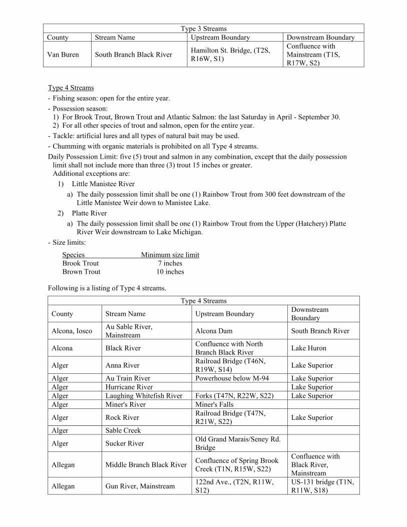
Type 3 Streams
- Fishing season: open for the entire year.
- Possession season: open for the entire year.
- Tackle: artificial lures and all types of natural bait may be used.
- Chumming with organic materials is prohibited on all Type 3 streams.
Daily Possession Limit: five (5) trout and salmon in any combination, except that the daily possession limit shall not include more than three (3) trout 15 inches or greater.
- Size limits:
Species Minimum size limit Brook Trout 15 inches Brown Trout 15 inches
Following is a listing of Type 3 streams.
Type 3 Streams County Stream Name Upstream Boundary Downstream Boundary Alcona Pine River F-41 Lake Huron
Allegan Black River Confluence of North & South Branch Black River
Lake Michigan
Allegan North Branch Black River 111th Ave. (T1N, R16W, S3) Confluence with mainstream
Allegan Kalamazoo River Calkins Dam (T2N, R14W, S15)
US-31
Alpena Thunder Bay River Ninth St. Dam Lake Huron Antrim Elk River Power Dam below Elk Lake Lake Michigan
Arenac Rifle River Sage Lake Rd. (T23N, R3E, S22)
Lake Huron
Baraga Falls River US-41 Hwy Lake Superior Baraga Sturgeon River Prickett Dam Lake Superior Berrien St. Joseph River Indiana State Line Lake Michigan Cheboygan Cheboygan River Cheboygan Dam Lake Huron Emmet Carp Lake River Bridge (T39N, R4W, S32) Lake Michigan
Gogebic Big Carp River
A point 100 yards downstream from Bathtub Falls (T50N, R45W, S1, NE¼, NW¼)
Lake Superior
Gogebic Black River Rainbow Falls (T49N, R46W, S10)
Lake Superior
Gogebic Little Carp River Traders Falls (T50N, R45W, S2)
Lake Superior
Gogebic Maple Creek Bridge (T49N, R46W, S18) Lake Superior Gogebic Ohman Creek Co. Rd. 505 Lake Superior Gogebic Presque Isle River Manabezho Falls Lake Superior Grand Traverse
Boardman River Sabin Dam Lake Michigan
Houghton Big Traverse River Gay-Lake Linden Rd.
Houghton Otter River Confluence of North Branch & West Branch Otter River
Sturgeon River
Houghton Pilgrim River US-41 Lake Superior Houghton Salmon-Trout River Redridge Dam Lake Superior Huron Bird Creek Huron Pigeon River Huron Pinnebog River Iosco Au Sable River Foote Dam Lake Huron
Type 3 Streams County Stream Name Upstream Boundary Downstream Boundary
Iosco East Branch Au Gres River (Whitney Drain)
M-55 (T22N, R6E, S21) Saginaw Bay
Iosco Van Etten Creek Van Etten Lake Lake Huron Iosco Tawas River
Isabella, Midland
Chippewa River Outlet of Lake Isabella, (T15N, R6W, S35)
Confluence with the Tittabawassee River (T14N, R2E, S21)
Leelanau Crystal River Fisher Dam Lake Michigan Leelanau Leland River None Lake Michigan
Manistee Bear Creek Co. Road 600 Confluence of Manistee River
Manistee Manistee River Tippy Dam Railroad Bridge below M-55 (T21N, R16W, S6)
Marquette Carp River Confluence of Morgan Creek (T47N, R25W, S4)
Lake Superior
Marquette Chocolay River Confluence of Big Creek (T47N, R24W, S9)
Lake Superior
Mason Lincoln River Confluence of North & South Branches of Lincoln River (T19N, R17W, S32)
Lake Michigan
Mason Pere Marquette River Reek Rd. (Indian Bridge) Old US-31 Mason Sable River Hamlin Lake Dam Lake Michigan Midland, Saginaw
Tittabawassee River Sanford Dam Confluence with Saginaw River
Muskegon Cedar Creek River Rd. Confluence of Muskegon River
Muskegon Muskegon River Bridge St. (New Bridge) M-120
Ontonagon Big Iron River Koshak Rd. Bridge (T49N, R43W, S2)
Lake Superior
Ontonagon West Branch Big Iron River Burnt Dam Bridge (T50N, R44W, S36)
Confluence with Big Iron River
Ontonagon Little Iron River Nonesuch Falls (T50N, R43N, S1)
Ontonagon East Branch Ontonagon River M-28
Ontonagon Firesteel (including East & West Branches)
M-26
Ontonagon Middle Branch Ontonagon River
Agate Falls
Ontonagon Misery River Bridge (T53N, R37W, S15) Ontonagon Ontonagon River
Ontonagon West Branch Ontonagon River
Confluence with Victoria Hydro Station Tail Race (T50N, R39W, S29, SE1/4 of SW1/4)
Ontonagon East Sleeping River Railroad trestle (T53N, R38W, S25)
Lake Superior
Presque Isle Swan River US-23 Bridge Lake Huron Presque Isle Trout River Dam (T35N, R5E, S17) Lake Huron Saginaw Saginaw River Saginaw Bay
St. Clair Black River Private Dam in Port Huron State Game Area
Confluence with St. Clair River
Type 3 Streams County Stream Name Upstream Boundary Downstream Boundary
Van Buren South Branch Black River Hamilton St. Bridge, (T2S, R16W, S1)
Confluence with Mainstream (T1S, R17W, S2)
Type 4 Streams
- Fishing season: open for the entire year.
- Possession season: 1) For Brook Trout, Brown Trout and Atlantic Salmon: the last Saturday in April - September 30. 2) For all other species of trout and salmon, open for the entire year.
- Tackle: artificial lures and all types of natural bait may be used.
- Chumming with organic materials is prohibited on all Type 4 streams.
Daily Possession Limit: five (5) trout and salmon in any combination, except that the daily possession limit shall not include more than three (3) trout 15 inches or greater. Additional exceptions are:
1) Little Manistee River
a) The daily possession limit shall be one (1) Rainbow Trout from 300 feet downstream of the Little Manistee Weir down to Manistee Lake.
2) Platte River
a) The daily possession limit shall be one (1) Rainbow Trout from the Upper (Hatchery) Platte River Weir downstream to Lake Michigan.
- Size limits:
Species Minimum size limit Brook Trout 7 inches Brown Trout 10 inches
Following is a listing of Type 4 streams.
Type 4 Streams
County Stream Name Upstream Boundary Downstream Boundary
Alcona, Iosco Au Sable River, Mainstream
Alcona Dam South Branch River
Alcona Black River Confluence with North Branch Black River
Lake Huron
Alger Anna River Railroad Bridge (T46N, R19W, S14)
Lake Superior
Alger Au Train River Powerhouse below M-94 Lake Superior Alger Hurricane River Lake Superior Alger Laughing Whitefish River Forks (T47N, R22W, S22) Lake Superior Alger Miner's River Miner's Falls
Alger Rock River Railroad Bridge (T47N, R21W, S22)
Lake Superior
Alger Sable Creek
Alger Sucker River Old Grand Marais/Seney Rd. Bridge
Allegan Middle Branch Black River Confluence of Spring Brook Creek (T1N, R15W, S22)
Confluence with Black River, Mainstream
Allegan Gun River, Mainstream 122nd Ave., (T2N, R11W, S12)
US-131 bridge (T1N, R11W, S18)
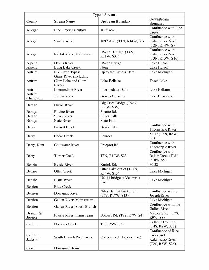
Type 4 Streams
County Stream Name Upstream Boundary Downstream Boundary
Allegan Pine Creek Tributary 101st Ave. Confluence with Pine Creek
Allegan Swan Creek 109th Ave. (T1N, R14W, S7) Confluence with Kalamazoo River (T2N, R14W, S9)
Allegan Rabbit River, Mainstream US-131 Bridge, (T4N, R11W, S31)
Confluence with Kalamazoo River (T3N, R15W, S16)
Alpena Devils River US-23 Bridge Lake Huron Alpena Long Lake Creek None Lake Huron Antrim Elk River Bypass Up to the Bypass Dam Lake Michigan
Antrim Grass River (including Clam Lake and Clam River)
Lake Bellaire Torch Lake
Antrim Intermediate River Intermediate Dam Lake Bellaire Antrim, Charlevoix
Jordan River Graves Crossing Lake Charlevoix
Baraga Huron River Big Erics Bridge (T52N, R30W, S35)
Baraga Ravine River Sicotte Rd. Baraga Silver River Silver Falls Baraga Slate River Slate Falls
Barry Bassett Creek Baker Lake Confluence with Thornapple River
Barry Cedar Creek Sources M-37 (T2N, R8W, S9)
Barry, Kent Coldwater River Freeport Rd. Confluence with Thornapple River
Barry Turner Creek T3N, R10W, S23 Confluence with Baker Creek (T3N, R10W, S9)
Benzie Betsie River Kurick Rd. M-22
Benzie Otter Creek Otter Lake outlet (T27N, R14W, S13)
Lake Michigan
Benzie Platte River US-31 bridge at Veteran’s Park
Lake Michigan
Berrien Blue Creek
Berrien Dowagiac River Niles Dam at Pucker St. (T7S, R17W, S13)
Confluence with St. Joseph River
Berrien Galien River, Mainstream Lake Michigan
Berrien Galien River, South Branch Confluence with the Galien River
Branch, St. Joseph
Prairie River, mainstream Bowers Rd. (T8S, R7W, S4) MacKale Rd. (T7S, R9W, S8)
Calhoun Nottawa Creek T3S, R5W, S35 Calhoun Co. line (T4S, R8W, S31)
Calhoun, Jackson
South Branch Rice Creek Concord Rd. (Jackson Co.)
Confluence of Rice Creek and Kalamazoo River (T2S, R6W, S25)
Cass Dowagiac Drain
Type 4 Streams
County Stream Name Upstream Boundary Downstream Boundary
Cass Dowagiac River, Mainstream
To source Pucker St. (T7S, R17W, S13)
Charlevoix Boyne River P.H. Dam Lake Charlevoix Charlevoix, Emmet
Bear River Walloon Lake Lake Michigan
Cheboygan, Emmet
Maple River Dam (T36N, R4W, S10) Mouth
Cheboygan Mill Creek Lake Huron
Cheboygan Pigeon River Pine Grove Campground Stairs
Mouth at Mullet Lake
Cheboygan Sturgeon River Afton Rd. (Webb Rd.) Mouth at Burt Lake Chippewa Albany Creek Bridge below lamprey weir Lake Huron Chippewa, Mackinac
Carp River, mainstream Lake Huron
Chippewa Halfaday Creek Lakeshore Dr. Lake Superior
Chippewa Pendill's Creek Second Dam (T47N, R4W, S28)
Lake Superior
Chippewa, Mackinac
Pine River H-40 Bridge Lake Huron
Crawford, Oscoda
Au Sable River, mainstream
McMasters Bridge Rd. (McMasters Bridge)
Rainbow Bend power line (T26N, R2E, S4)
Delta Bark River 9 Rd. (Section line between T38N, R24W, S20, 29)
Lake Michigan
Delta Big Fishdam River Co. Rd. 2222 Bridge (T41N, R18W, S9)
Lake Michigan
Delta Days River
M-35 Bridge Lake Michigan
Delta, Dickinson
Ford River Northland Truck Trail (T43N, R27W, S35) Dickinson Co.
Lake Michigan
Delta Rapid River Co. Rd. S-15 (T42N, R21W, S19)
Lake Michigan
Delta Sturgeon River Co. Rd. 442 Bridge (T42N, R20W, S13)
Lake Michigan
Delta Tacoosh River 29th Lane (County Rd. G-24) Lake Michigan
Delta Whitefish River 38th Rd.(USFS 2236) US-2 Bridge in T41N, R21W, S28
Houghton Elm River Rd. Bridge between (T53N, R36W, S3, 10)
Houghton Little Elm River Agate Beach Rd. (T53N, R36W, S6)
Houghton South Branch Elm River Bridge (T54N, R36W, S29, 32)
Houghton Graveraet River Mouth of Deer Creek (T45N, R36W, S2)
Houghton Trap Rock River Cemetery Rd. (T56N, R32W, S29)
Ionia Dickerson Creek Ionia, Montcalm
Fish Creek Sidney Rd. Confluence with Maple River
Ionia, Montcalm
Prairie Creek East Muskrat Rd. Confluence with Grand River
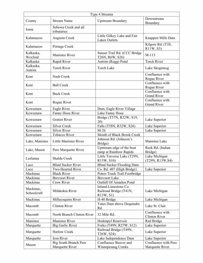
Type 4 Streams
County Stream Name Upstream Boundary Downstream Boundary
Ionia Sebewa Creek and all tributaries
Kalamazoo Augusta Creek Little Gilkey Lake and Fair Lakes Outlets
Knappen Mills Dam
Kalamazoo Portage Creek Kilgore Rd. (T3S, R11W, S3)
Kalkaska, Wexford
Manistee River Sunset Trail Rd. (CCC Bridge T26N, R6W, S26)
M-115
Kalkaska Rapid River Antrim (Rugg) Pond Torch River Kalkaska, Antrim
Torch River Torch Lake Lake Skegemog
Kent Nash Creek Confluence with Rogue River
Kent Ball Creek Confluence with Rogue River
Kent Buck Creek Confluence with Grand River
Kent Rogue River Confluence with Grand River
Keweenaw Eagle River Dam, Eagle River Village Keweenaw Fanny Hooe River Lake Fanny Hooe
Keweenaw Gratiot River Bridge (T57N, R32W, S19, 20)
Lake Superior
Keweenaw Silver Creek Falls (T58N, R32W, S26) Lake Superior Keweenaw Silver River M-26 Lake Superior Keweenaw Tobacco River Mouth of Black Brook Creek
Lake, Manistee Little Manistee River Johnson Rd. (Johnson’s Bridge)
Manistee Lake
Lake, Mason Pere Marquette River Upstream edge of the boat ramp at Rainbow Rapids
Reek Rd. (Indian Bridge)
Leelanau Shalda Creek Little Traverse Lake (T29N, R13W, S10)
Lake Michigan (T29N, R13W,S4)
Luce Blind Sucker River Blind Sucker Flooding Dam Luce Two-Hearted River Co. Rd. 407 (High Bridge) Lake Superior Mackinac Black River Peters Truck Trail Footbridge Mackinac Brevoort River Brevoort Lake Mackinac Crow River Outfall Of Amadon Pond
Mackinac, Schoolcraft
Milakokia River Inland-Limestone Co. Railroad Bridge (T41N, R13W, S1)
Lake Michigan
Mackinac Millecoquins River H-40 Bridge Lake Michigan
Macomb Clinton River Yates Dam above Dequindre Rd.
Lake St. Clair
Macomb North Branch Clinton River 32 Mile Rd. Confluence with Clinton River
Manistee Manistee River Hodenpyl Reservoir Red Bridge Marquette Big Garlic River Forks (T49N, R27W, S12) Lake Superior
Marquette Harlow Creek Railroad Bridge (T49N, T26W, S24)
Lake Superior
Marquette Iron River Lake Independence Dam Lake Superior
Mason Big South Branch Pere Marquette River
Confluence Beaver and Winnepesaug Creeks
Confluence with Pere Marquette River
Type 4 Streams
County Stream Name Upstream Boundary Downstream Boundary
Mason Sable River Pole Bridge (T19N, R15W, S3)
Hamlin Lake
Mecosta, Montcalm, Newaygo
Little Muskegon River
Mecosta, Osceola
Muskegon River US-10 (T18N, R8W, S34) DNRE River Bend Bluffs PAS (T15N, R9W, S31)
Menominee Big Cedar River Veterans Memorial Park Dam (T38N, R26W, S9)
Lake Michigan
Menominee Walton Creek Westmann Dam (T35N, R25W, S18)
Lake Michigan
Montmorency Thunder Bay River Atlanta Dam Sucker Creek confluence upstream of Hillman Pond
Muskegon White River Hesperia Dam Lake Michigan
Newaygo Muskegon River Croton Dam Bridge St. (New Bridge)
Newaygo Tamarack Creek
Oceana Pentwater River Hart Dam
Confluence with Pentwater Lake (Long Bridge Rd. or B15)
Oceana North Branch Pentwater River
Oceana Dr. Confluence with Pentwater River, Mainstream
Oceana North Branch White River Arthur Rd. Confluence with White River
Ontonagon Union River South Boundary Rd. (T51N, R42W, S22)
Lake Superior
Oscoda Au Sable River, mainstream
Mio Dam Mio power line (T26N, R3E, S7)
Ottawa Crockery Creek Moore Rd. Confluence with Grand River
Ottawa, Muskegon
North Branch Crockery Creek, Mainstream
Kenowa Ave. (T10N, R13W, S36)
Confluence with Crockery Creek, Mainstream at Ravenna
Ottawa Sand Creek Presque Isle Ocqueoc River Barnhart Lake Lake Huron Schoolcraft Manistique River Papermill Dam St. Clair Belle River
St. Clair Mill Creek Confluence with Black River
St. Joseph Mill Creek and tributaries Preston Rd. (T7S, R12W, S7) Impoundment (T7S, R12W, S32)
St. Joseph Unnamed tributary (T6S, R10W, S26)
Van Buren Brush Creek except Reynolds Lake Drain
63rd Ave. Confluence with Paw Paw River
Type 4 Streams
County Stream Name Upstream Boundary Downstream Boundary
Van Buren
South Branch Paw Paw River, West Branch Paw Paw River, and (Gates Drain and tributaries
Rail road bridge downstream of I-94 (T3S, R14W, S14)
Van Buren Pine Creek 101st Ave. (T1N, R12W, S32)
Wayne Huron River Belleville Lake Dam Lake Erie
Gear Restricted Streams
NOTE:
1) On any stream reach that is being managed under gear restrictions, it shall be unlawful to use or possess live bait, dead or preserved bait, organic or processed food, or scented material on any of the waters or on shore.
Au Sable River, Mainstream (Crawford County) from Burton’s Landing to South Wakeley Bridge Rd. (Wakeley Bridge)
- Fishing season: open for the entire year.
Possession season: closed for the entire year; except that for children under the age of 12-years old the possession season is open for the entire year.
- Tackle: artificial flies only
- Daily Possession Limit: zero (0) trout; except that for children under the age of 12-years old the daily possession limit shall be one (1) trout.
- Size limits: not applicable; except that for children under the age of 12-years old the minimum size limit shall be 8 inches and the maximum size limit shall be 12 inches for all species of trout. Trout less than 8 inches or greater than 12 inches must be released.
- Mileage: 9.0 miles.
Au Sable River, mainstream (Crawford County) from South Wakeley Bridge Rd. (Wakeley Bridge) to McMasters Bridge Rd. (McMasters Bridge)
- Fishing season: open for the entire year.
- Possession season: last Saturday in April - September 30 for Brook Trout and Brown Trout; open for the entire year for Rainbow Trout.
- Tackle: artificial lures only.
- Daily Possession Limit: two (2) trout; except that the daily possession limit shall not include more than one (1) trout 18 inches or greater.
- Size limits: minimum size limit: Brook Trout – 10 inches; Brown Trout – 18 inches; Rainbow Trout – 10 inches.
- Mileage: 8.0 miles.
Au Sable River, mainstream (Oscoda County) from Mio power line (T26N, R3E, S7) to Evans Rd. (McKinley Bridge)
- Fishing season: open for the entire year.
- Possession season: last Saturday in April - September 30 for Brook Trout and Brown Trout; open for the entire year for Rainbow Trout.
- Tackle: artificial lures only.
- Daily Possession Limit: two (2) trout; except that the daily possession limit shall not include more than one (1) trout 18 inches or greater.
- Size limits: minimum size limit: Brook Trout – 7 inches; Brown Trout – 18 inches; Rainbow Trout – 10 inches.
- Mileage: 15.0 miles.
Au Sable River, North Branch (Crawford County) from Sheep Ranch to confluence with Mainstream
- Fishing season: open for the entire year.
- Possession season: last Saturday in April - September 30 for Brook Trout and Brown Trout; open for the entire year for Rainbow Trout.
- Tackle: artificial flies only.
- Daily possession limit: two (2) trout; except that the daily possession limit shall not include more than one (1) trout 18 inches or greater.
- Size limits: minimum size limit: Brook Trout – 10 inches; Brown Trout – 18 inches; Rainbow Trout – 10 inches
- Mileage: 20.7 miles
Au Sable River, South Branch (Crawford County) from Chase Bridge Rd. (Chase Bridge) to Lower High Banks
- Fishing season: open for the entire year.
- Possession season: closed for the entire year; except that for children under the age of 12-years old the possession season is open for the entire year.
- Tackle: artificial flies only.
- Daily possession limit: zero (0) trout; except that for children under the age of 12-years old the daily possession limit shall be one (1) trout.
- Size limits: not applicable; except that for children under the age of 12-years old the minimum size limit shall be 8 inches and the maximum size limit shall be 12 inches for all species of trout. Trout less than 8 inches or greater than 12 inches must be released.
- Mileage: 4.3 miles.

Au Sable River, South Branch (Crawford County) from Lower High Banks to confluence with Mainstream
- Fishing season: open for the entire year.
- Possession season: last Saturday in April - September 30 for Brook Trout and Brown Trout; open for the entire year for Rainbow Trout.
- Tackle: artificial flies only.
- Daily possession limit: two (2) trout; except that the daily possession limit shall not include more than one (1) trout 18 inches or greater.
- Size limits: minimum size limit: Brook Trout – 10 inches; Brown Trout – 18 inches; Rainbow Trout – 10 inches.
- Mileage: 11.5 miles.
Black River (Otsego and Montmorency counties) from Tin Shanty Bridge Rd. to the Town Corner Lake Stairs (T32N, R1E, S31 SE/SE)
- Fishing season: open for the entire year.
- Possession season: last Saturday in April - September 30 for Brook Trout; open for the entire year for Brown Trout and Rainbow Trout.
- Tackle: artificial lures only.
- Daily possession limit: five (5) trout; except that the daily possession limit shall not include more than two (2) Brook Trout.
- Size limits: minimum size limit: Brook Trout – 10 inches; Brown Trout – 8 inches; Rainbow Trout – 10 inches.
- Mileage: 4.4 miles.
Cooks Run, (Iron County) from US Forest Hwy 16 to Confluence with South Branch Paint River
From the last Saturday in April - September 30, this reach of stream shall be managed under Type 2 regulations, except the minimum size limit for Brook Trout shall be 7 inches.
From October 1 - the Friday before the last Saturday in April, this reach of stream shall be managed under gear restricted regulations as follows:
- Fishing season: October 1 - the Friday before the last Saturday in April.
- Possession season: closed; except that for children under the age of 12-years old the possession season is open.
- Tackle: artificial flies only.
- Daily possession limit: zero (0) trout; except that for children under the age of 12-years old the daily possession limit shall be one (1) trout.
- Size limits: not applicable; except that for children under the age of 12-years old the minimum size limit shall be 8 inches and the maximum size limit shall be 12 inches for all species of trout. Trout less than 8 inches or greater than 12 inches must be released.
- Mileage: 4.5 miles.
Duck Creek (Gogebic County) from Railroad Bridge (T44N, R39W, S16 SE1/4 SE1/4) to Confluence with Middle Branch Ontonagon River
- Fishing season: open for the entire year.
- Possession season: last Saturday in April - September 30 for Brook Trout and Brown Trout; open for the entire year for Rainbow Trout.
- Tackle: artificial lures only.
- Daily possession limit: two (2) trout.
- Size limits: minimum size limit: all species of trout – 10 inches.
- Mileage: 6.5 miles.
Escanaba River (Delta County) from Boney Falls Dam to Mouth of Silver Creek (T40N, R23W, S11)
- Fishing season: open for the entire year.
- Possession season: last Saturday in April - September 30 for Brook Trout and Brown Trout; open for the entire year for Rainbow Trout.
- Tackle: artificial lures only.
- Daily possession limit: two (2) trout.
- Size limits: minimum size limit: Brook Trout – 10 inches; Brown Trout – 12 inches; Rainbow Trout – 12 inches.
- Mileage: 14.2 miles.
Fox River (Schoolcraft County) from Fox River State Forest Campground (T46N, R14W, S11) to M-28
From the last Saturday in April - September 30, this reach of stream shall be managed under Type 1 regulations.
From October 1 - the Friday before the last Saturday in April, this reach of stream shall be managed under gear restricted regulations as follows:
- Fishing season: October 1 - the Friday before the last Saturday in April.
- Possession season: closed; except that for children under the age of 12-years old the possession season is open.
- Tackle: artificial flies only.
- Daily possession limit: zero (0) trout; except that for children under the age of 12-years old the daily possession limit shall be one (1) trout.
- Size limits: not applicable; except that for children under the age of 12-years old the minimum size limit shall be 8 inches and the maximum size limit shall be 12 inches for all species of trout. Trout less than 8 inches or greater than 12 inches must be released.
- Mileage: 7.6 miles.
Huron River (Oakland County) from the Sign below Moss Lake Outlet to the Signs 100 Yards below Wixom Road (T2N, R7E, S13)
From the last Saturday in April - September 30, this reach of stream shall be managed under Type 1 regulations.
From April 1 - the Friday before the last Saturday in April, this reach of stream shall be managed under gear restricted regulations as follows:
- Fishing season: April 1 - the Friday before the last Saturday in April.
- Possession season: closed; except that for children under the age of 12-years old the possession season is open.
- Tackle: artificial flies only.
- Daily possession limit: zero (0) trout; except that for children under the age of 12-years old the daily possession limit shall be one (1) trout.
- Size limits: not applicable; except that for children under the age of 12-years old the minimum size limit shall be 8 inches and the maximum size limit shall be 12 inches for all species of trout. Trout less than 8 inches or greater than 12 inches must be released.
- Mileage: 2.0 miles.
Little Manistee River (Lake County) from North Peacock Trail (Spencer’s Bridge T19N, R13W, S5) to Johnson Rd. (Johnson’s Bridge T20N, R14W, S24)
- Fishing season: open April 1 - December 31.
- Possession season: last Saturday in April - September 30 for Brook Trout and Brown Trout; open April 1 - December 31 for all other species of trout and salmon.
- Tackle: artificial flies only.
- Daily possession limit: two (2) fish, any combination of trout and salmon.
- Size limits: minimum size limit: Brook Trout – 10 inches; Brown Trout – 15 inches; all other species of trout and salmon – 10 inches.
- Mileage: 7.5 miles.
Manistee River (Crawford County) from CO. Rd. 612 to M-72
- Fishing season: open for the entire year.
- Possession season: last Saturday in April - September 30 for Brook Trout and Brown Trout; open for the entire year for Rainbow Trout.
- Tackle: artificial lures only.
- Daily possession limit: two (2) trout; except that the daily possession limit shall not include more than one (1) trout 18 inches or greater.
- Size limits: minimum size limit: Brook Trout – 10 inches; Brown Trout – 18 inches; Rainbow Trout – 10 inches.
- Mileage: 9.2 miles.
Manistee River (Crawford and Kalkaska counties) from M-72 to Sunset Trail Rd. (CCC Bridge T26N, R6W, S26)
- Fishing season: open for the entire year.Possession season: last Saturday in April - September 30 for Brook Trout and Brown Trout; open for the entire year for Rainbow Trout.
- Tackle: artificial flies only.
- Daily possession limit: two (2) trout; except that the daily possession limit shall not include more than one (1) trout 18 inches or greater.
- Size limits: minimum size limit: Brook Trout – 10 inches; Brown Trout – 18 inches; Rainbow Trout – 10 inches.
- Mileage: 16.7 miles.
Paint Creek (Oakland County) from Gunn Rd. to Tienken Rd.
- Fishing season: last Saturday in April - September 30 for all species of trout.
- Possession season: last Saturday in April - September 30 for all species of trout.
- Tackle: artificial lures only.
- Daily possession limit: two (2) trout.
- Size limits: minimum size limit: all species of trout – 14 inches.
- Mileage: 5.0 miles.
Paint River, South Branch (Iron County) from the Mouth of Cooks Run (T44N, R36W, S28) to the Mouth of the North Branch of the Paint River (T44N, R35W, S8)
From the last Saturday in April - September 30, this reach of stream shall be managed under Type 2 regulations, except the minimum size limit for Brook Trout shall be 7 inches.
From October 1 - the Friday before the last Saturday in April, this reach of stream shall be managed under gear restricted regulations as follows:
- Fishing season: October 1 - the Friday before the last Saturday in April.
- Possession season: closed; except that for children under the age of 12-years old the possession season is open.
- Tackle: artificial flies only.
- Daily possession limit: zero (0) trout; except that for children under the age of 12-years old the daily possession limit shall be one (1) trout.
- Size limits: not applicable; except that for children under the age of 12-years old the minimum size limit shall be 8 inches and the maximum size limit shall be 12 inches for all species of trout. Trout less than 8 inches or greater than 12 inches must be released.
- Mileage: 10.0 miles.
Pere Marquette River (Lake County) from M-37 to the Downstream Edge of the Boat Ramp/Slide at Gleason’s Landing (T17N, R14W, S13)
- Fishing season: open for the entire year.
- Possession season: closed for the entire year; except that for children under the age of 12-years old the possession season is open for the entire year.
- Tackle: artificial flies only.
- Daily possession limit: zero (0) trout and salmon; except that for children under the age of 12-years old the daily possession limit shall be one (1) trout or salmon.
- Size limits: not applicable; except that for children under the age of 12-years old the minimum size limit shall be 8 inches and the maximum size limit shall be 12 inches for all species of trout and salmon. Trout and salmon less than 8 inches or greater than 12 inches must be released.
- Mileage: 8.5 miles.
Pere Marquette River (Lake County) from the Downstream Edge of the Boat Ramp/Slide at Gleason’s Landing (T17N, R14W, S13) to the Upstream Edge of the Boat Ramp at Rainbow Rapids
From September 1 - the Friday before the last Saturday in April, this reach of stream shall be managed
under Type 4 regulations, with the following exceptions:
- Fishing season: September 1 - the Friday before the last Saturday in April. - Possession season: September 1 - the Friday before the last Saturday in April. - Daily Possession Limit: zero (0) Brook Trout; zero (0) Brown Trout; one (1) Rainbow Trout.
- Size limits: not applicable for Brook Trout and Brown Trout.
From the last Saturday in April - August 31, this reach of stream shall be managed under gear restricted regulations as follows:
- Fishing season: last Saturday in April - August 31.
- Possession season: last Saturday in April - August 31.
- Tackle: artificial lures only.
- Daily possession limit: two (2) trout or salmon; except that the daily possession limit shall not include more than one (1) Brown Trout 18 inches or greater, and except that the daily possession limit shall not include more than one (1) Rainbow Trout.
- Size limits: minimum size limit: all species of salmon – 10 inches; Brook Trout – 8 inches; Brown Trout – 8 inches; Rainbow Trout – 8 inches; except that the harvest of fish greater than 14 inches and less than 18 inches shall be prohibited for Brook Trout, Brown Trout, and Rainbow Trout.
- Mileage: 10.5 miles.
Pigeon River (Cheboygan and Otsego counties) from Elk Hill Campground Horse Trail to Pine Grove Campground Stairs
- Fishing season: open for the entire year.
- Possession season: last Saturday in April - September 30 for Brook Trout and Brown Trout; open for the entire year for Rainbow Trout.
- Tackle: artificial lures only.
- Daily possession limit: two (2) trout; except that the daily possession limit shall not include more than one (1) Brown Trout.
- Size limits: minimum size limit: Brook Trout – 10 inches; Brown Trout – 12 inches; Rainbow Trout – 10 inches.
- Mileage: 5.3 miles.
Adfluvial Brook Trout Restoration Areas
The following locations have more restrictive Brook Trout regulations. Fishing regulations on these waters shall supersede those in other sections which in any way conflict with the following: the possession season for Brook Trout is from the last Saturday in April – September 30, the minimum size limit on Brook Trout, Lake Trout, and Splake shall be 20 inches with a daily possession limit of one (1) Brook Trout, Lake Trout or Splake total combined.
1) Big Garlic River and tributaries (Marquette County), from County Road 550 (T50N, R26W, S33) downstream to Lake Superior (T50N, R26W, S21).
2) Big Huron River (Baraga and Marquette Counties), from Big Eric’s Bridge (T52N, R30W, S35) downstream to Lake Superior (T52N, R29W, S18).
3) Iron River (Marquette County), from Lake Independence Dam (T51N, R27W, S13) downstream to Lake Superior (T51N, R26W, S18).
4) Little Huron River (Marquette County), from unnamed bridge crossing located at the southern border of section 20 (T52N, R29W, S20) downstream to Lake Superior (T52N, R29W, S17).
5) Pilgrim River (Houghton County), from Paradise Road (T54N, R33W, S5) downstream to mouth at Portage Lake (T54N, R33W, S7).
6) Portage/Torch Lake system (including the Portage River, Portage Canal, North Entry and South Entry, Houghton County).
7) Ravine River (Baraga County), from Sicotte Road (T51N, R31W, S2) downstream to Huron Bay (T51N, R31W, S4).
8) Silver River (Baraga County), from Silver River Falls (T51N, R32W, S26) downstream to Huron Bay (T51N, R31W, S18).
9) Slate River (Baraga County), from Slate River Falls (1/2 mile upstream from Skanee Road T51N, R31W, S9) downstream to Huron Bay (T51N, R31W, S8).
Upper Peninsula 10-Possession Brook Trout Waters The following list of waters have expanded opportunities where anglers may harvest 5 additional
Brook Trout combined with the daily possession limit of 5 trout for up to 10 brook trout per angler per day total.
Alger County:
Sucker River watershed: o Sucker River and all tributaries upstream of Old Seney Road (CR 781).
Baraga County: Falls River watershed:
o Falls River from highway Blackjack Road (Golf Course Road) upstream to confluence with Ogema Creek and Burns Creek.
Huron River watershed: o West Branch Huron River upstream from confluence with Robarge Creek.
Michigamme River watershed: o East Branch Fence River (Baraga and Iron Counties) upstream from North Fence Line
River Road. Silver River watershed:
o Silver River and all tributaries upstream from Upper Silver Falls (northeast of Herman). Sturgeon River watershed:
o Sidnaw Creek (Baraga and Houghton Counties) and all tributaries upstream from confluence with Sturgeon River.
o Sturgeon River upstream from highway Nestoria/Herman Road. Chippewa County:
Pine River watershed: o North Branch Pine River and all tributaries upstream from H-40 (in Rudyard).
Delta County: Whitefish River watershed:
o Haymeadow Creek and all tributaries upstream from Whitefish River. Fishdam River watershed:
o Fishdam River (Delta and Schoolcraft Counties) and all tributaries upstream from County Road 2222 Bridge.
Dickinson County: Sturgeon River watershed:
o East Branch Sturgeon River and all tributaries upstream from Leeman Road. o Fern Creek and all tributaries upstream from Pine Creek Lake Road.
Gogebic County: Black River watershed:
o Black River upstream of South Black River Road, excluding McDonald Creek. o Powdermill Creek and all tributaries upstream from Highway US- 2.
Ontonagon River watershed: o Bluff Creek and all tributaries upstream from Choate Road. o Tamarack River (Gogebic and Iron Counties) from confluence with Middle Branch
Ontonagon River at Federal Forest Road 4500. Presque Isle watershed:
o Little Presque Isle River and all tributaries upstream from confluence with mainstream Presque Isle River.
Houghton County: Graveraet River watershed:
o Deer Creek upstream from confluence with Graveraet River. Ontonagon River watershed:
o East Branch Ontonagon River (Houghton and Iron Counties) upstream from confluence with Glitter Creek near Lower Dam Road crossing.
Otter River watershed: o Sante River and all tributaries upstream from North Branch Otter River.
Sturgeon River watershed. o Sidnaw Creek (Baraga and Houghton Counties) and all tributaries upstream from
confluence with Sturgeon River. Iron County:
Michigamme River watershed: o Deer River and all tributaries upstream from Bradley Road. o East Branch Fence River (Baraga and Iron Counties) upstream from from North Fence
Line River Road. o Margeson Creek and tributaries upstream from Noyes Road.
Ontonagon River watershed: o East Branch Ontonagon River (Houghton and Iron Counties) upstream from confluence
with Glitter Creek near Lower Dam Road crossing. o Tamarack River (Gogebic and Iron Counties) from confluence with Middle Branch
Ontonagon River at Federal Forest Road 4500. Keweenaw County:
Tobacco River watershed: o Tobacco River and all tributaries upstream from Gagnon Road.
Luce County: Sage River watershed:
o West Branch Sage River and all tributaries upstream of Highway M-28. Two Hearted River watershed:
o North Branch Two Hearted River and all tributaries upstream of County Road 418 Bridge.
Mackinac County: Black River watershed:
o Black River and all tributaries upstream from Peters Truck Trail footbridge. Paquin Creek watershed:
o Paquin Creek and all tributaries upstream from Lake Michigan. Marquette County:
Dead River watershed: o Boise Creek and all tributaries upstream from Red Road.
Michigamme River watershed: o Trout Falls Creek and tributaries upstream from County Road LB (18 Road).
Ontonagon County: Iron River watershed:
o Big Iron River and all tributaries upstream from Federal Forest Road 791 (County Road 360).
Ontonagon River watershed: o Bluff Creek (Ontonagon and Gogebic Counties) and all tributaries upstream from Choate
Road. Firesteel River watershed:
o West Branch Firesteel River and all tributaries upstream from Highway M-38. Schoolcraft County:
Fishdam River watershed: o Fishdam River (Delta and Schoolcraft Counties) and all tributaries upstream from County
Road 2222 Bridge. Manistique River watershed:
o Driggs River and all tributaries upstream from Highway M-28.
o Middle and South Branch Stutts Creek and all tributaries upstream from State Highway M-94.
The Department shall evaluate and determine whether up to 20 percent of the total mileage of the Type 1 waters in the Upper Peninsula may be recommended for this regulation. In 2018, the Department shall provide a report on this evaluation at a regular meeting of the Natural Resources Commission.
Research Areas
The following streams have ongoing research projects associated with them. Fishing regulations on these streams shall be as follows:
1) Salmon-Trout River (Marquette County) from Lower Falls (T51N, R28W, S13) down to Lake Superior: Fishing season: last Saturday in April - August 14; Possession season: last Saturday in April - August 14; Tackle: artificial lures and all types of natural bait may be used; Daily possession limit: five (5) trout and salmon in any combination, except that the daily possession limit shall not include more than three (3) trout 15 inches or greater and no more than one (1) Brook Trout; Size limits: minimum size limit: Brook Trout – 18 inches; Brown Trout – 8 inches; all other species of trout or salmon – 10 inches.
Refuges
The following areas are established as refuge areas for Lake Trout rehabilitation and shall be closed to the taking, keeping, and sport fishing for Lake Trout.
1) Lake Michigan (North part) All waters enclosed within an area bounded by a line commencing at a point (45°30' north latitude, 85°15' west longitude) 7¼ miles due west of the northwest corner of Section 30, T36N, R6W, (Emmet County, Michigan) on the Lake Michigan shoreline; then proceeding due west for 12 miles (to 45°30' north latitude, 85°30' west longitude); then proceeding due north for 6 miles (to 45°35' north latitude, 85°30' west longitude); then proceeding due west for 8 miles (to 45°35' north latitude, 85°40' west longitude); then proceeding due north for 11¼ miles (to 45°45' north latitude, 85°40' west longitude); then proceeding due west 16 miles (to 45°45' north latitude, 86°00' west longitude); then proceeding due south for 40 miles (to 45°10' north latitude, 86°00' west longitude); then proceeding due east for 8½ miles to (45°10' north latitude, 85°50' west longitude); then proceeding due north for 6 miles (to 45°15' north latitude, 85°50' west longitude); then proceeding due east for 7½ miles (to 45°15' north latitude, 85°40' west longitude); then proceeding due north for 6 miles (to 45°20' north latitude, 85°40' west longitude); then proceeding due east 16½ miles (to 45°20' north latitude, 85°20' west longitude) then proceeding due north 6 miles (to 45°25' north latitude, 85°20' west longitude); then, proceeding due east 4 miles (to 45°25' north latitude, 85°15' west longitude); then proceeding northerly to the point of beginning (45°30' north latitude, 85°15' west longitude).
2) Lake Michigan (Mid Lake) All waters enclosed within an area bounded by a line commencing at a point 15 miles (43°40' north latitude, 86°50' west longitude) due west of the half (1/2) section line of Section 25, T15N, R19W, on the Lake Michigan shoreline (Oceana County); then proceeding 14.5 miles due west to the Michigan/Wisconsin boundary; then proceeding southerly along the boundary line to a point (43°03.5' north latitude, 87°05' west longitude) due west of the mouth of the Grand River (T8N, R16W, S30, Ottawa County) on the Lake Michigan shore; then proceeding due east 14 miles (to 43°03.5' north latitude, 86°50' west longitude); and then northerly to the point of beginning (43°40' north latitude, 86°50' west longitude).
3) Lake Huron (North end) All waters enclosed within an area bounded by a line commencing at the southwest corner of Section 17, T41N, R5E (Chippewa County) on the Lake Huron shoreline for the point of beginning and proceeding due south 15 miles (to 45°45'North latitude, 83°50' west longitude), then proceeding due east 8 miles (to 45°45'North latitude, 83°40' west longitude); then proceeding
6 miles due south (to 45°40'North latitude, 83°40' west longitude); then proceeding due east to the Michigan-Ontario border; then proceeding northwesterly and then northeasterly along said border to a point due south of the southeast corner of Section 1, T41N, R7E (Chippewa County), on the said shoreline, and westerly along said shoreline to the point of beginning.
4) Lake Huron (6 Fathom Bank) All waters enclosed within an area bounded by a line commencing at a point in Lake Huron at 45°00’north latitude, 82°45’E west longitude; then proceeding due east to the international boundary line between the U.S. and Canada; thence in a southeasterly direction to 44°40’north latitude; thence due west to 44°40’north latitude, 82°45’E west longitude; then proceeding due north to the point of beginning.
This Order shall be assigned number FO-200.18, and is entitled “Statewide Trout, Salmon, Whitefish, Lake Herring, and Smelt Regulations.”
This Order supersedes the Order entitled “Statewide Trout, Salmon, Whitefish and Lake Herring Regulations,” which became effective June 9, 2017, and is assigned number FO-200.17. This Order shall take effect on April 1, 2018 and shall remain in effect until amended/rescinded.