Embed Size (px)
Citation preview

I-405 Bellevue Nickel Improvement Project I-90 to Southeast 8th Street
FISHERIES & AQUATIC RESOURCES DISCIPLINE REPORT January 2006
%&e(
!"b$
AÉ
!"̀$
!"̀$
Aæ
%&e(
LakeWashington
B o t h e l l
K i r k l a n d
B e l l e v u e
R e n t o n
AÊ
AÐ
Aí
Aô
AÌ
Aí
Aç
AÅ
Arterial Road
Freeway
Municipality
Lake
Park
M0 2
Mi le s
I-405 Project Area
BellevueNickel
Study Area

This document should be cited as: Washington State Department of Transportation. 2005. I-405 Bellevue Nickel Improvement Project. Fisheries and Aquatic Resources Discipline Report. November. Bellevue, WA. Prepared for the Washington State Department of Transportation, Urban Corridors Office, and the Federal Highway Administration, Olympia, WA.

Title VI WSDOT ensures full compliance with Title VI of the Civil Rights Act of 1964 by prohibiting discrimination against any person on the basis of race, color, national origin or sex in the provision of benefits and services resulting from its federally assisted programs and activities. For questions regarding WSDOT's Title VI Program, you may contact the Department's Title VI Coordinator at 360. 705.7098.
Americans with Disabilities Act (ADA) Information If you would like copies of this document in an alternative format -- large print, Braille, cassette tape, or on computer disk, please call 360.705.7097. Persons who are deaf or hard of hearing, please call the Washington State Telecommunications Relay Service, or Tele-Braille at 7-1-1, Voice 1.800.833.6384, and ask to be connected to 360.705.7097.

This page is blank for double-sided copying.
Contents i
Table of Contents Introduction ...............................................................................................1 What alternatives do we analyze in this discipline report?................................................................................3
What is the No Build Alternative? ..............................................................................................................3 What are the principal features of the Build Alternative? ...........................................................................3
Why do we consider fisheries and aquatic resources as we plan this project?...............................................13 What are the key points of this report? ...........................................................................................................14
Existing Conditions ................................................................................17 How and when did we collect information on fisheries and aquatic resources? .............................................17 Is the project within a recognized tribal fishing area? .....................................................................................18 What is our study area and how did we determine it? ....................................................................................18 What are the general habitat characteristics of the study area? .....................................................................20 What fish and aquatic species occur in the study area? .................................................................................21 Do any federally listed aquatic species or federal aquatic species of concern occur in the study area? ........22 Do any state-listed or other state priority aquatic species occur in or around the study area? .......................23 What are the habitat characteristics of the streams located in the study area? ..............................................24
Unnamed Tributaries to Mercer Slough Wetlands ...................................................................................24
Potential Effects......................................................................................37 What methods did we use to evaluate potential effects on fisheries and aquatic resources?.........................37 How will the project affect fisheries and aquatic resources?...........................................................................38
No Build Alternative .................................................................................................................................38 Build Alternative.......................................................................................................................................39
How will project construction affect fisheries and aquatic resources? ............................................................44 Direct Disturbance and Stream Diversions ..............................................................................................45 In-Stream Sedimentation .........................................................................................................................45 Stream Buffer and Riparian Vegetation ...................................................................................................46 Other Potential Construction Effects........................................................................................................47
How will the project affect federally listed species and federal species of concern? ......................................47 Did we consider potential cumulative effects for the Build and No Build Alternatives?...................................48
Measures to Avoid or Minimize Project Effects ...................................49 What will we do to avoid or minimize potential negative effects on fish and other aquatic species or aquatic
habitat? ....................................................................................................................................................49 What will we do to minimize construction effects? ..........................................................................................50 How will the project compensate for unavoidable adverse effects to fish or aquatic habitat?.........................51
Fisheries and Aquatic Resources Discipline Report
WSDOT I-405 Bellevue Nickel Improvement Project
ii Contents
References...............................................................................................53
Exhibits Exhibit 1. Project Vicinity Map..................................................................................................................... 2
Exhibit 2. Proposed Bellevue Nickel Project Improvements (Sheet 1 of 3)................................................. 5
Exhibit 3. Proposed Bellevue Nickel Project Improvements (Sheet 2 of 3)................................................. 6
Exhibit 4. Proposed Bellevue Nickel Project Improvements (Sheet 3 of 3)................................................. 7
Exhibit 5. Proposed Wetland Mitigation Area............................................................................................ 11
Exhibit 6. Conceptual Stream Mitigation Plan ........................................................................................... 12
Exhibit 7. Study Area Boundaries ............................................................................................................. 19
Exhibit 8. Map of “Median Stream” ........................................................................................................... 28
Exhibit 9. Map of Kelsey Creek................................................................................................................. 32
Exhibit 10. Map of Sturtevant Creek ........................................................................................................... 33
Exhibit 11. Map of Mercer Slough............................................................................................................... 34
Exhibit 12. Summary of Permanent Bellevue Nickel Overwater, In-Stream, and Riparian Buffer Encroachment Effects for the Study Area ................................................................................. 40
Exhibit 13. Summary of Bellevue Nickel Streams: Fish Use, Temporary Effects, and Permanent Effects for the Study Area .......................................................................................................................... 41

Fisheries and Aquatic Resources Discipline Report
WSDOT I-405 Bellevue Nickel Improvement Project
Contents iii
Appendices Appendix A. Avoidance and Minimization Measures
Appendix B. Memo from D. Koellmann to MAP and I-405 Teams Summarizing Stream Survey Methodology
Appendix C. Stream Survey Summaries
Fisheries and Aquatic Resources Discipline Report
WSDOT I-405 Bellevue Nickel Improvement Project
iv Glossary
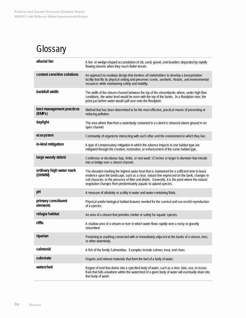
Glossary alluvial fan A fan- or wedge-shaped accumulation of silt, sand, gravel, and boulders deposited by rapidly
flowing streams when they reach flatter terrain.
context sensitive solutions An approach to roadway design that involves all stakeholders to develop a transportation facility that fits its physical setting and preserves scenic, aesthetic, historic, and environmental resources while maintaining safety and mobility.
bankfull width The width of the stream channel between the top of the streambanks where, under high flow conditions, the water level would be even with the top of the banks. In a floodplain river, the point just before water would spill over onto the floodplain.
best management practices (BMPs)
Method that has been determined to be the most effective, practical means of preventing or reducing pollution.
daylight The area where flow from a waterbody contained in a culvert is released above ground in an open channel.
ecosystem Community of organisms interacting with each other and the environment in which they live.
in-kind mitigation A type of compensatory mitigation in which the adverse impacts to one habitat type are mitigated through the creation, restoration, or enhancement of the same habitat type.
large woody debris Coniferous or deciduous logs, limbs, or root wads 12 inches or larger in diameter that intrude into or bridge over a stream channel.
ordinary high water mark (OHWM)
The elevation marking the highest water level that is maintained for a sufficient time to leave evidence upon the landscape, such as a clear, natural line impressed on the bank, changes in soil character, or the presence of litter and debris. Generally, it is the point where the natural vegetation changes from predominately aquatic to upland species.
pH A measure of alkalinity or acidity in water and water-containing fluids.
primary constituent elements
Physical and/or biological habitat features needed for the survival and successful reproduction of a species.
refugia habitat An area of a stream that provides shelter or safety for aquatic species.
riffle A shallow area of a stream or river in which water flows rapidly over a rocky or gravelly streambed.
riparian Pertaining to anything connected with or immediately adjacent to the banks of a stream, river, or other waterbody.
salmonid A fish of the family Salmonidae. Examples include salmon, trout, and chars.
substrate Organic and mineral materials that form the bed of a body of water.
watershed Region of land that drains into a specified body of water, such as a river, lake, sea, or ocean. Rain that falls anywhere within the watershed of a given body of water will eventually drain into that body of water.

Fisheries and Aquatic Resources Discipline Report
WSDOT I-405 Bellevue Nickel Improvement Project
Acronyms v
Acronyms and Abbreviations BNSF Burlington Northern Santa Fe Railway
BMPs best management practices
CWA Clean Water Act
CZMA Coastal Zone Management Act
dbh diameter at breast height
DDT dichloro-diphenyl-trichloroethane
EA environmental assessment
Ecology Washington State Department of Ecology
EIS environmental impact statement
ESA Endangered Species Act
ESU evolutionary significant unit
FEIS final environmental impact statement
FHWA Federal Highway Administration
FTA Federal Transit Administration
HOV high-occupancy vehicle
I-405 Interstate 405
I-90 Interstate 90
IDT interdisciplinary team
LWD large woody debris
MP milepost
NB northbound
NEPA National Environmental Policy Act
NMFS National Marine Fisheries Service
OHWM ordinary high water mark
PCEs primary constituent elements
Fisheries and Aquatic Resources Discipline Report
WSDOT I-405 Bellevue Nickel Improvement Project
vi Acronyms
Acronyms and Abbreviations ROD record of decision
ROW right of way
SB southbound
SE southeast
SMA Shoreline Management Act
TESC temporary erosion and sediment control
USFWS U.S. Fish and Wildlife Service
WDFW Washington State Department of Fish and Wildlife
WRIA water resource inventory area
WSDOT Washington State Department of Transportation
Introduction 1
Introduction In 1998, the Washington State Department of Transportation (WSDOT) joined with the Federal Highway Administration (FHWA), the Federal Transit Administration (FTA), Central Puget Sound Regional Transit Authority (Sound Transit), King County, and local governments in an effort to reduce traffic congestion and improve mobility in the Interstate 405 (I-405) corridor. In fall 2002, the combined efforts of these entities culminated in the I-405 Corridor Program Final Environmental Impact Statement (EIS) and FHWA Record of Decision (ROD).
The ROD selected a project alternative that would widen I-405 by as many as two lanes in each direction throughout its 30-mile length. The ultimate configuration of the selected alternative includes buffers separating general-purpose lanes from parallel high-occupancy vehicle (HOV) lanes (potentially used by future high-capacity transit). The design also allows for expanded “managed lane” operations along I-405 that could include use of HOV lanes by other user groups, such as trucks.
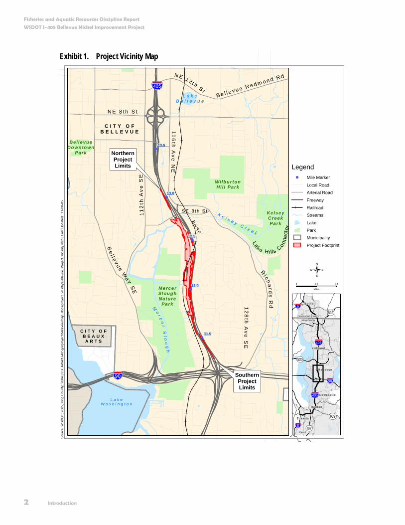
In 2003, the Washington State legislature approved a statewide transportation-funding plan called the “nickel package.” The nickel package provided funding for congestion relief projects in three critical traffic hotspots along the I-405 Corridor: Renton, Bellevue, and Kirkland. The Bellevue Nickel Improvement Project is one of several projects now moving forward as part of a phased implementation of the I-405 Corridor Program. Exhibit 1 shows the location of the Bellevue Nickel Improvement Project.
In 2003, the Washington State legislature approved a statewide transportation-funding plan called the “nickel package.” The nickel package provides funding for congestion relief projects in three critical traffic hotspots along the I-405 Corridor, including Bellevue.
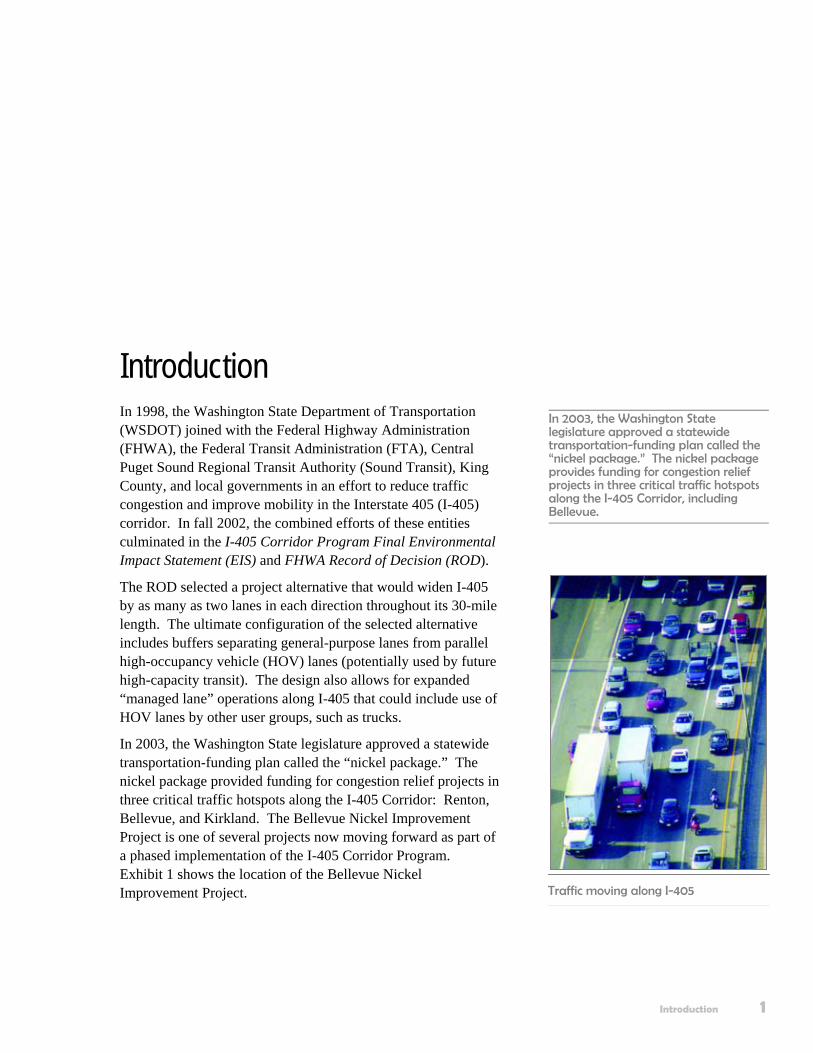
Traffic moving along I-405
Fisheries and Aquatic Resources Discipline Report
WSDOT I-405 Bellevue Nickel Improvement Project
2 Introduction
Exhibit 1. Project Vicinity Map
!
!
!
!
!
Me
r ce
r Sl o
ug
h
L a k eB e l l e v u e
WilburtonHil l Park
KelseyCreekPark
MercerSloughNature
Park
Bel levueDowntown
Park
Be
l l e v u e Wa y S
E
Ri c h a
rds R
d12
8th
Ave
SE
112
th A
ve
SE
S E 8 t h S t
116
th A
ve N
E
N E 8 t h S t
N E 1 2 t h S t
BN
SF
K e l s e y C r e e k
13.0
12.0
13.5
12.5
11.5
!"b$
%&e(
SouthernProjectLimits
NorthernProjectLimits
Lake Hi ll s C
onnec
tor
L a k eW a s h i n g t o n
C I T Y O FB E A U X
A R T S
C I T Y O FB E L L E V U E
B e l l e v u e R e d m o n d R d
Sour
ce: W
SD
OT;
200
5, K
ing
Cou
nty;
200
4 | \
\SEA
W40
5\40
5gis
\pro
ject
\bel
levu
e\m
ap_d
ocs\
proj
ect_
vici
ntiy
\Bel
levu
e_P
roje
ct_V
icin
ity.m
xd |
Last
Upd
ated
: 11
-08-
05
Legend! Mile Marker
Local Road
Arterial Road
Freeway
Railroad
Streams
Lake
Park
Municipality
Project Footprint
0 0.2 0.4
Miles
{
AÊ
AÉ
!"b$
Aæ
%&e(
%&e(
!"̀$
!"̀$
Ne w c a s t l e
Snohomish County
King County
Aç
B e l l e v ue
Re n t o n
K e n t
B o t h e l l
K i r k l an d
T uk w i l a

Fisheries and Aquatic Resources Discipline Report
WSDOT I-405 Bellevue Nickel Improvement Project
Introduction 3
In keeping with the direction established in the Final EIS (FEIS) and ROD, we are preparing a National Environmental Policy Act (NEPA) Environmental Assessment (EA) that focuses on project-level effects of constructing and operating the Bellevue Nickel Improvement Project.
We will base the EA on the analysis in the I-405 Corridor Program Final EIS, and will describe any new or additional project changes, information, effects, or mitigation measures not identified and analyzed in the corridor-level FEIS. The project-level EA for the Bellevue Nickel Improvement Project will not reexamine the corridor-level alternatives, effects, and mitigation measures presented in the corridor-level FEIS, or the decisions described in the ROD.
What alternatives do we analyze in this discipline report? This discipline report is one of 19 environmental elements WSDOT will study to analyze the effects of the Bellevue Nickel Improvement Project. All of the discipline reports will analyze one build alternative and one “no build” or “no action” alternative. This approach is consistent with FHWA’s guidelines for preparing a NEPA EA.
What is the No Build Alternative? NEPA requires us to include and evaluate the No Build Alternative in this discipline report. We use this approach to establish an existing and future baseline for comparing the effects associated with the Build Alternative. We assume the No Build Alternative will maintain the status quo: only routine activities such as road maintenance, repair, and safety improvements would occur within the corridor between now and 2030. The No Build Alternative does not include improvements that would increase roadway capacity or reduce congestion on I-405. We describe these improvements further in the Bellevue Nickel Improvement Project Traffic and Transportation Discipline Report.
What are the principal features of the Build Alternative? The Build Alternative will add one new general-purpose lane in each direction along a 2-mile section of I–405 between Interstate 90 (I-90) and SE 8th Street. The new pavement will
The Environmental Assessment will describe new project changes, information, effects, or mitigation measures, but the assessment will not revisit the alternatives, effects, and mitigation measures evaluated in the corridor-level EIS or the decisions documented in the Record of Decision.
We assume the No Build Alternative will maintain the status quo: only routine activities such as road maintenance, repair, and safety improvements would occur within the corridor between now and 2030.
Fisheries and Aquatic Resources Discipline Report
WSDOT I-405 Bellevue Nickel Improvement Project
4 Introduction
generally be constructed on the inside or “median” side of I-405. After restriping, the new lanes will be located on the outside of the existing roadway. The Build Alternative also includes new stormwater management facilities and a substantial upgrade of existing drainage structures and systems. Other project activities associated with the Build Alternative include developing off-site wetland mitigation as well as on- or off-site stream mitigation areas to compensate for the loss of these resources within the project area. We expect project construction to begin in spring 2007 and the improved roadway to be open to traffic by fall 2009.
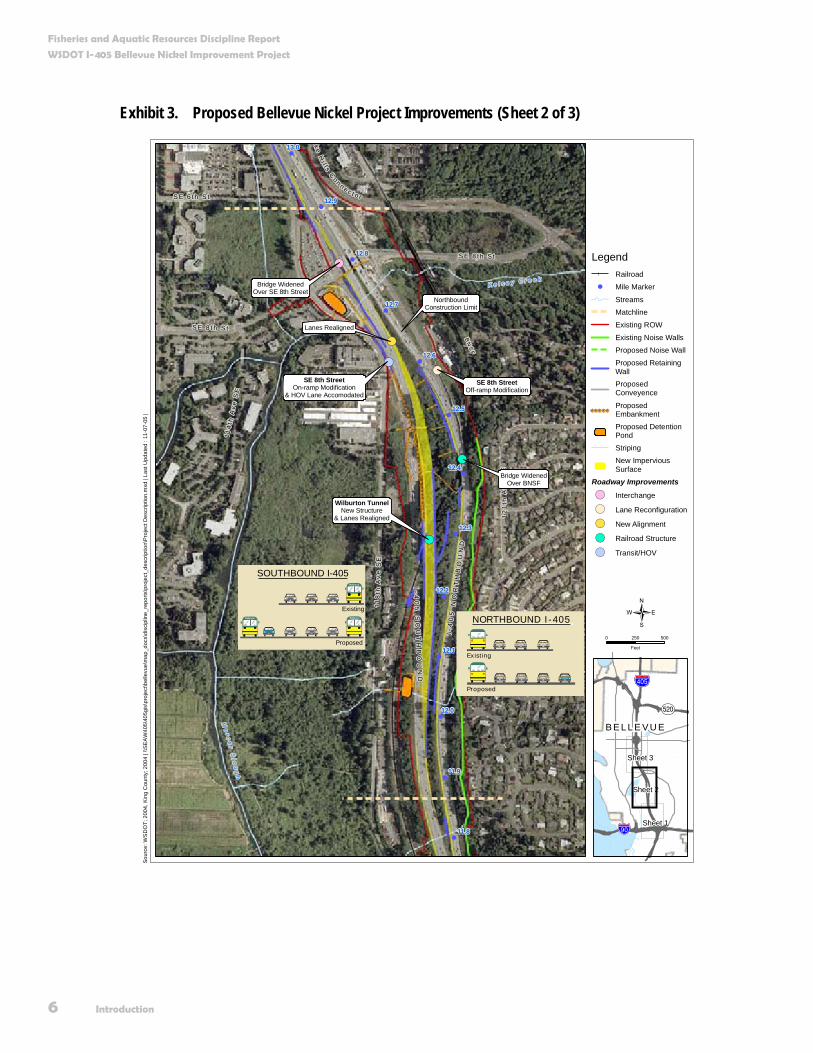
Improvements to Southbound I-405 In the southbound (SB) direction, we plan to add one new travel lane from approximately Southeast (SE) 8th Street to I-90 (Exhibits 2, 3, and 4). In addition, the existing outside HOV lane at I-90 will be extended north so that it begins at the on-ramp from SE 8th Street. In order to add these lanes and maintain traffic flow during construction, we will shift approximately 3,000 feet of the SB roadway as much as 200 feet east into the existing median. The relocated SB roadway will connect to the existing SB travel lanes just north of the I-90 interchange, and south of the existing bridge over SE 8th Street.
We will build a new tunnel underneath the Burlington Northern Santa Fe (BNSF) railroad, just east of the existing Wilburton Tunnel, to accommodate the relocated and widened SB roadway. The existing tunnel does not have the capacity to accommodate additional lanes of SB traffic.
The existing SB travel lanes and the Wilburton Tunnel will remain open to traffic during construction of the new tunnel and the relocated/widened SB lanes. We will also build the new tunnel wide enough to accommodate additional lanes. The existing tunnel will remain after we complete the improvements.
We will add one lane in the southbound direction of I-405 from approximately SE 8th Street to I-90.

Fisheries and Aquatic Resources Discipline Report
WSDOT I-405 Bellevue Nickel Improvement Project
Introduction 5
Exhibit 2. Proposed Bellevue Nickel Project Improvements (Sheet 1 of 3)
!(!
!
!
!
!
!
!
!
!
ce
rS
l ou
gh
12
4t h
Ave
SE
118
t h A
ve S
E
BN
SF
S E 3 2 n d S t
120 t
h A
ve S
E
I - 9 0
I - 40
5
I-90On-ramp Modification
NorthboundConstruction Limit
SouthboundConstruction Limit
11.9
11.8
11.7
11.6
11.5
11.4
11.3
11.1
11.2
SOUTHBOUND I-405
Existing
Proposed
Bellevue
Bellevue
Bellevue
Bellevue
NORTHBOUND I-405
Existing
Proposed
Sour
ce: W
SD
OT;
200
4, K
ing
Cou
nty;
200
4 | \
\SE
AW
405\
405g
is\p
roje
ct\b
elle
vue\
map
_doc
s\di
scip
line_
repo
rts\p
roje
ct_d
escr
iptio
n\Pr
ojec
t Des
crip
tion.
mxd
| La
st U
pdat
ed :
11-0
7-05
|
LegendRailroad
! Mile Marker
Streams
Matchline
Existing ROW
Existing Noise Walls
Proposed Noise Wall
Proposed RetainingWallProposedConveyence
ProposedEmbankmentProposed DetentionPond
Striping
New ImperviousSurface
Roadway Improvements
!( Interchange
!( Lane Reconfiguration
!( New Alignment
!( Railroad Structure
!( Transit/HOV
0 250 500
Feet
{
B E L L E V U EAÉ
!"b$
%&e(
Sheet 1
Sheet 2
Sheet 3
Fisheries and Aquatic Resources Discipline Report
WSDOT I-405 Bellevue Nickel Improvement Project
6 Introduction
Exhibit 3. Proposed Bellevue Nickel Project Improvements (Sheet 2 of 3)
!(
!(
!(
!(
!(!(
!
!
!
!
!
!
!
!
!
!
!
!
!
I -4
05
NO
RT
HB
OU
ND
BN
SF
I-40
5 S
OU
TH
BO
UN
D
S E 8 t h S t
118
th A
ve
SE
12
1th
Ave
SE
114
t h A
v e S
E
Me
r ce
r Sl o
ug
h
S E 8 t h S t
K e l s e y C r e e k
k e H
i l l s Co n n e c t o rS E 6 t h S t
Wilburton TunnelNew Structure
& Lanes Realigned
Bridge WidenedOver BNSF
SE 8th StreetOff-ramp Modification
SE 8th StreetOn-ramp Modification
& HOV Lane Accomodated
Lanes Realigned
Bridge WidenedOver SE 8th Street
NorthboundConstruction Limit
12.0
13.0
12.4
12.3
12.2
12.1
11.9
11.8
12.5
12.6
12.7
12.8
12.9
NORTHBOUND I-405
Existing
Proposed
SOUTHBOUND I-405
Existing
Proposed
Bellevue
BellevueBellevue
Sou
rce:
WS
DO
T; 2
004,
Kin
g C
ount
y; 2
004
| \\S
EA
W40
5\40
5gis
\pro
ject
\bel
levu
e\m
ap_d
ocs\
disc
iplin
e_re
ports
\pro
ject
_des
crip
tion\
Pro
ject
Des
crip
tion.
mxd
| La
st U
pdat
ed :
11-0
7-05
|
LegendRailroad
! Mile Marker
Streams
Matchline
Existing ROW
Existing Noise Walls
Proposed Noise Wall
Proposed RetainingWallProposedConveyence
ProposedEmbankmentProposed DetentionPond
Striping
New ImperviousSurface
Roadway Improvements
!( Interchange
!( Lane Reconfiguration
!( New Alignment
!( Railroad Structure
!( Transit/HOV
0 250 500
Feet
{
B E L L E V U EAÉ
!"b$
%&e(
Sheet 1
Sheet 2
Sheet 3
Fisheries and Aquatic Resources Discipline Report
WSDOT I-405 Bellevue Nickel Improvement Project
Introduction 7
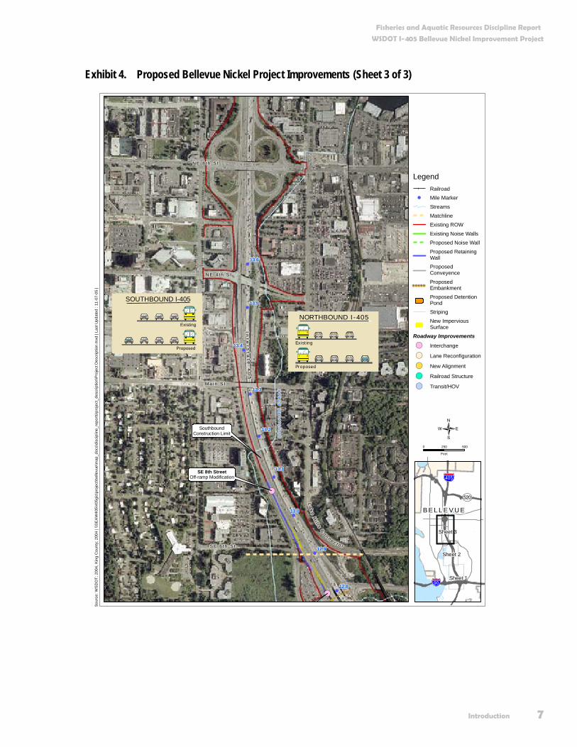
Exhibit 4. Proposed Bellevue Nickel Project Improvements (Sheet 3 of 3)
!(
!(
!
!
!
!
!
!
!
!
!
116
th A
ve
NE
N E 8 t h S t
112
th A
ve
NE
N E 4 t h S t
BN
SF
Ma i n S t
110
th A
ve
NE
La
k e Hi l l s C
o n n e c t o r
Int e
r st a
t e 4
05
Stu
rte
va
nt
Cr
ee
k
S E 6 t h S t
SE 8th StreetOff-ramp Modification
SouthboundConstruction Limit
13.0
12.8
12.9
13.3
13.4
13.5
13.6
13.2
13.1
NORTHBOUND I-405
Existing
Proposed
SOUTHBOUND I-405
Existing
Proposed
Bellevue
Bellevue
Sou
rce:
WS
DO
T; 2
004,
Kin
g C
ount
y; 2
004
| \\S
EA
W40
5\40
5gis
\pro
ject
\bel
levu
e\m
ap_d
ocs\
disc
iplin
e_re
ports
\pro
ject
_des
crip
tion\
Pro
ject
Des
crip
tion.
mxd
| La
st U
pdat
ed :
11-0
7-05
|
LegendRailroad
! Mile Marker
Streams
Matchline
Existing ROW
Existing Noise Walls
Proposed Noise Wall
Proposed RetainingWallProposedConveyence
ProposedEmbankmentProposed DetentionPond
Striping
New ImperviousSurface
Roadway Improvements
!( Interchange
!( Lane Reconfiguration
!( New Alignment
!( Railroad Structure
!( Transit/HOV
0 250 500
Feet
{
B E L L E V U EAÉ
!"b$
%&e(
Sheet 1
Sheet 2
Sheet 3
Fisheries and Aquatic Resources Discipline Report
WSDOT I-405 Bellevue Nickel Improvement Project
8 Introduction
We will also include the following improvements in the Build Alternative:
Modify the existing off-ramp at SE 8th Street to make room for an additional southbound lane on I-405. The off-ramp will then become a single-lane, optional off-ramp (i.e., the off-ramp will no longer be an “exit only” off-ramp).
Build a retaining wall between the SB travel lanes and the off-ramp at SE 8th Street.
Widen the existing bridge over SE 8th Street to the west to accommodate the new SB lane.
Modify the existing on-ramp at SE 8th Street to tie into the relocated SB general-purpose travel lanes.
Reconfigure the on-ramp at SE 8th Street to accommodate the extended outside HOV lane.
Temporarily shift the existing BNSF railroad track from its current alignment to allow for continuous railroad operation during construction of the new tunnel.
Construct retaining walls along the eastern edge of the relocated SB travel lanes.
Improvements to Northbound I-405 In the northbound (NB) direction, we plan to add one new travel lane from approximately I-90 to SE 8th Street (Exhibits 2, 3, and 4). We will add one new lane to the NB ramp from I-90. We will shift the NB lanes to allow all of the proposed widening to occur on the inside, or median side of the existing roadway.
Additional improvements include:
Re-stripe the westbound/eastbound I-90 on-ramp to NB I-405 resulting in one lane becoming two lanes in the NB direction.
Widen, shift, and re-stripe NB I-405 travel lanes north of I-90 to allow the westbound I-90 to NB I-405 on-ramp and the eastbound I-90 to NB I-405 on-ramp to enter I-405 without having to merge into a single lane.
Construct several retaining walls needed for road widening in locations that allow for existing and future widening of I-405.
We will add one lane in the northbound direction of I-405 from approximately I-90 to SE 8th Street. All widening of the northbound mainline will occur on the inside (median side) of the existing roadway.

Fisheries and Aquatic Resources Discipline Report
WSDOT I-405 Bellevue Nickel Improvement Project
Introduction 9
Construct noise barrier approximately 725 feet long and 16 feet high (see Exhibit 2).
Widen the existing bridge over the BNSF Railroad to the west to accommodate the new NB lane.
Modify the NB off-ramp to SE 8th Street to make it a single-lane “exit-only” off-ramp.
Transition the NB travel lanes back into the existing lane configuration before crossing over SE 8th Street.
Improvements to the Stormwater Management System Managing stormwater for the I-405 Bellevue Nickel Improvement Project involves the collection and treatment of rainfall runoff from the new project pavement consistent with the guidelines in the WSDOT Highway Runoff Manual.
Currently, we treat less than 5 percent of the existing runoff from paved surfaces in the project area before discharging it. We will improve this condition by treating 17 percent more area than the new paved surface area we create. By treating a greater area, we improve flow control and remove pollutants from a portion of the existing roadway as well as from newly constructed areas.
Reconfiguration and new construction associated with the SB lanes will mean that we need to replace much of the existing drainage system. We will continue to use open roadside ditches along the shoulders of the roadway shoulders where possible. We will use standard WSDOT catch basins and manhole structures to move the roadway runoff to a system of stormwater drain pipes. These features will transport runoff to treatment and flow-control facilities within the existing right of way (ROW).
We will construct three new stormwater ponds (detention ponds combined with stormwater treatment wetlands) as part of the project and enlarge the existing pond at SE 8th Street. Two of the new ponds will be located south of the Wilburton Tunnel between the SB lanes and the BNSF railroad ROW. We will construct the third new pond in the northwest quadrant of the I-90/I-405 interchange. The project will discharge treated stormwater following existing flow patterns to Mercer Slough or to the wetlands that surround it.
Avoidance Measures WSDOT will use best management practices (BMPs), WSDOT Standard Specifications, and design elements to avoid or minimize potential effects to the environment for the Bellevue
Best Management Practices (BMPs)
BMPs are generally accepted techniques that, when used alone or in combination, prevent or reduce adverseeffects of a project. Examples include erosion control measures and construction management to minimize traffic disruption. Please see Appendix A for a complete list of BMPs.
WSDOT Standard Specifications
Guidelines and procedures established by WSDOT for roadway design and construction in a variety of design, engineering, and environmental manuals.

Fisheries and Aquatic Resources Discipline Report
WSDOT I-405 Bellevue Nickel Improvement Project
10 Introduction
Nickel Improvement Project. Collectively, these measures to avoid or minimize potential effects to the environment are known as “avoidance measures.” We describe these measures in more detail in an Appendix A. If the Bellevue Nickel Improvement Project has additional effects not addressed in the avoidance measures, we will address these measures through mitigation.
Wetland and Stream Mitigation Sites We will compensate for adverse effects to wetlands and their buffers by creating just over an acre of wetland within the boundaries of Kelsey Creek Park (Exhibit 5). The site is located north of the intersection of Richards Road and the Lake Hills Connector.
Our general concept will be to create an area that will transition from forested land beside the Lake Hills Connector to wetlands within Kelsey Creek Park. We will reshape the surface area to create favorable conditions for the necessary wetland aquatic characteristics, and we will replant and enhance habitat in the area by constructing habitats and replanting adjacent roadside areas with forest-type vegetation.
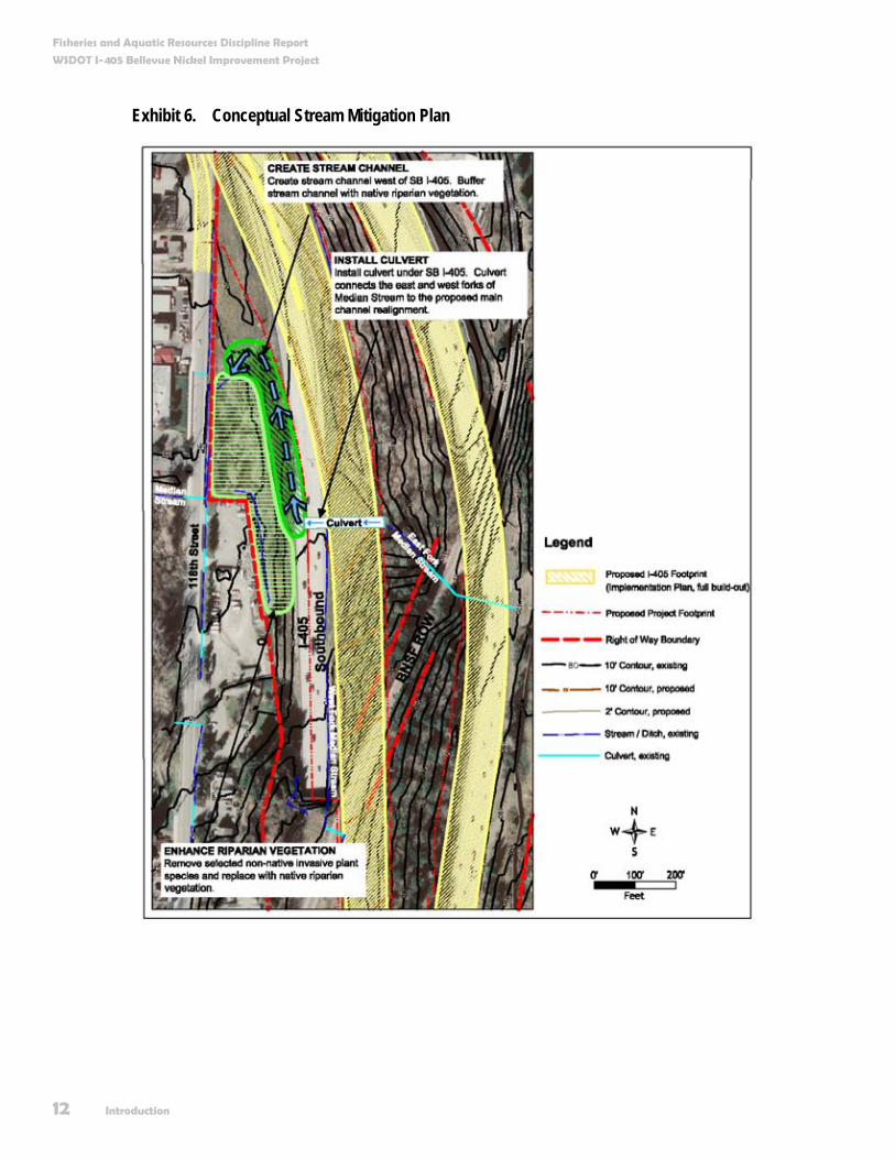
Similarly, we will compensate for unavoidable effects to “Median Stream,” the unnamed stream within the I-405 median. We have developed a conceptual stream mitigation plan that includes on-site habitat restoration and creation. The conceptual stream mitigation plan includes the following specific elements (See Exhibit 6):
Connect the new Median Stream culvert under I-90 to the existing channel and wetland located west of SB I-405.
Create approximately 500 linear feet of stream channel along the western slope of SB I-405.
Buffer the created stream channel with approximately 16,000 square feet of native streamside vegetation.
Enhance approximately 300 linear feet of riparian habitat west of SB I-405 by removing selected non-native invasive plant species and replacing with native streamside vegetation.
We provide more detailed information about mitigation efforts planned in conjunction with the Bellevue Nickel Improvement in the Surface Water, Floodplains, and Water Quality, and Wetlands Discipline Reports.

Fisheries and Aquatic Resources Discipline Report
WSDOT I-405 Bellevue Nickel Improvement Project
Introduction 11
Exhibit 5. Proposed Wetland Mitigation Area
!
!
!
!
!
%&e(
Be l l e v u e W
ay SE
112
th A
ve S
E
S E 8 t h S t
BN
SF
!"b$
%&e(
13.5
13.0
12.5
12.0
11.5
K e l s e y C r e e k
Me
r ce
r Sl o
ug
h
12
8th
Ave
SE
Rich
ard
s Rd
116
th A
ve N
ELake H ills Connector
SouthernProject Limits
NorthernProject Limits
Sour
ce: W
SD
OT;
200
5, K
ing
Cou
nty;
200
4 | \
\SE
AW40
5\40
5gis
\pro
ject
\bel
levu
e\m
ap_d
ocs\
disc
iplin
e_re
ports
\wet
land
s\Pr
opos
ed_M
itiga
tion_
Area
.mxd
| La
st U
pdat
ed :
09-2
0-05
LegendStreamsRailroad
! Mile MarkerProject FootprintProposed WetlandMitigation Area
0 500 1,000
Feet
{
AÊ
AÉ
!"b$
Aæ
%&e(
%&e(
!"̀$
!"̀$
Ne w c a s t l e
Snohomish County
King County
Aç
B e l l e v ue
Re n t o n
K e n t
B o t h e l l
K i r k l an d
T uk w i l a
Fisheries and Aquatic Resources Discipline Report
WSDOT I-405 Bellevue Nickel Improvement Project
12 Introduction
Exhibit 6. Conceptual Stream Mitigation Plan

Fisheries and Aquatic Resources Discipline Report
WSDOT I-405 Bellevue Nickel Improvement Project
Introduction 13
Why do we consider fisheries and aquatic resources as we plan this project? We define fisheries and aquatic resources as water environments, such as streams, rivers, and lakes, and the water-dependent organisms that inhabit those environments. These resources are important elements of the ecosystem in which we live — providing food, livelihood, employment, income, and cultural value. The habitats in which fish and other aquatic organisms live also provide valuable habitat and food sources for various terrestrial species.
Numerous federal, state, and local laws and regulations exist to protect and preserve these resources, and to help guide development of various project elements. Federal regulations or statutes regulating activities that can affect fisheries and aquatic resources, include the:
Clean Water Act (CWA) Sections 401 (water quality) and 404 (fill or discharge of materials into waters of the US, including wetlands)
Endangered Species Act (ESA); the Rivers and Harbors Act (Section 10)
Coastal Zone Management Act (CZMA)
State laws that regulate these resources include:
State Hydraulic Code
Water Quality Standards For Surface Waters of the State of Washington
Shoreline Management Act (SMA), implemented via the Revised Code of Washington (Chapters 77.55, 90.48, and 90.58 RCW)
Local critical areas ordinances also regulate potential effects to these resources. In general, all of these regulations protect aquatic habitats and species, both aquatic and terrestrial, which depend on these resources.
Understanding how the Bellevue Nickel Improvement Project will affect fisheries and aquatic resources is an integral part of the environmental review process. This report quantifies both the beneficial as well as the negative effects to fisheries and aquatic resources resulting from the Bellevue Nickel Improvement Project.
Ecosystem
An ecosystem is a community of organisms interacting with each other and the environment in which they live.

Fisheries and Aquatic Resources Discipline Report
WSDOT I-405 Bellevue Nickel Improvement Project
14 Introduction
What are the key points of this report? The Bellevue Nickel Improvement Project study area contains a variety of important fisheries and aquatic resources that are integral to the long-term viability and sustainability of the ecosystems in the study area. This report details the anticipated effects to these resources resulting from the project.
The No Build Alternative would have few direct effects on the fisheries and aquatic resources in the study area. The No Build Alternative would not remove, relocate, fill, culvert, shade, or otherwise directly disturb any streams. It would disturb riparian buffers only minimally through routine maintenance such as mowing or brushing. However, existing roadway-related stormwater runoff patterns would result in continued negative effects to aquatic resources from poor water quality caused by untreated stormwater and large quantities of water stemming from a lack of stormwater volume controls (e.g., stormwater retention ponds). Water quality and quantity impairment can lead to the harm or mortality (death) of a variety of aquatic organisms and can reduce the overall health of an ecosystem over time.
The Build Alternative will have direct permanent effects on the fisheries and aquatic resources in the study area. Some of these effects will be beneficial (e.g., providing stormwater treatment facilities and mitigation for affected areas that will leave the environment in a more natural state than present conditions) and some negative (e.g., encroachment into riparian buffers and culverting of sections of certain streams). The key effects to fisheries and aquatic resources from the project relate to “Median Stream” (the unnamed stream within the I-405 median, 08.MS-12.4, which crosses I 405 between MP 12.3 and 12.5). Project design will place this tributary almost entirely into a culvert. WSDOT will mitigate effects to this unnamed tributary in accordance with applicable local, state, and federal laws.
The Build Alternative also involves construction activities that could temporarily affect fisheries and aquatic resources in the study area. In-water disturbances due to construction and stream diversions, and changes to stream buffer and riparian vegetation could cause in-stream sedimentation. WSDOT will use appropriate and available construction BMPs to avoid and/or minimize these temporary effects from construction.
In all cases where adverse effects on fisheries and aquatic resources are unavoidable, WSDOT will mitigate for the affected resources. Mitigation will also help to offset any temporary

Fisheries and Aquatic Resources Discipline Report
WSDOT I-405 Bellevue Nickel Improvement Project
Introduction 15
construction-related negative effects on fisheries resources. Onsite mitigation will occur in the immediate vicinity of Median Stream to compensate for litterfall, water quality, shading, and in-stream habitat functions. Details contained within the stream mitigation plan are pending.
Litterfall
Litterfall consists of leaves, twigs, and other plant material that fall to the ground or into a waterbody. Litterfall isimportant as it provides a valuable food source for insects in the waterbodies that, in turn, are a food source for fish and other aquatic species.


Existing Conditions 17
Existing Conditions How and when did we collect information on fisheries and aquatic resources? We collected existing information on fisheries and aquatic resources in the study area by reviewing available literature, performing internet searches, and conducting interviews with various state, county, and local agencies and tribal interests, including the Northwest Indian Fisheries Commission. We collected additional information in the field by 1) conducting surveys on the streams in the study area to determine the quantity and quality of existing riparian habitat, and 2) attending a series of Interdisciplinary Team (IDT) site visits where experts in fisheries, wetlands, road design, drainage design and permitting reviewed the natural and constructed features located in the study area.
During April and May 2005, we surveyed and characterized the in-stream and riparian habitats of the following streams within the study area:
Trail Creek
Kelsey Creek
Sturtevant Creek
several smaller unnamed streams
Habitat features measured or described in the survey included general stream characteristics such as length, width, and depth of the waterbody; the quantity and quality of in-stream habitat; the
Riparian Habitat
Riparian habitat is the aquatic and terrestrial habitat adjacent to streams, lakes, estuaries, or other waterways.
Typical highway construction scene
Fisheries and Aquatic Resources Discipline Report
WSDOT I-405 Bellevue Nickel Improvement Project
18 Existing Conditions
nature and type of riparian vegetation, substrate composition, presence and size of large woody debris (LWD); and any observed fish use. We conducted habitat surveys from 300 feet upstream to 0.25 mile downstream of the project footprint for each stream. We include the specific methodologies used to conduct the stream surveys in Appendix B of this report.
We also identified existing fish passage barriers in the study area. Based on the results of the investigation, WSDOT will determine which fish passage barriers will require retrofitting or replacement.
Is the project within a recognized tribal fishing area? Mercer Slough, the largest contiguous wetland connected to Lake Washington, is located in the study area and included in the Muckleshoot Tribe’s usual and accustomed fishing areas.
The Muckleshoot Tribe harvests adult salmon from the study area pursuant to judicially recognized treaty rights, as interpreted by the Boldt Decision of 1974. Over the years, judicial decisions have affirmed that treaty tribes have a right to harvest fish free of state interference, subject to conservation principals, to co-manage the fishery resource with the state, and to harvest up to 50 percent of the harvestable fish.
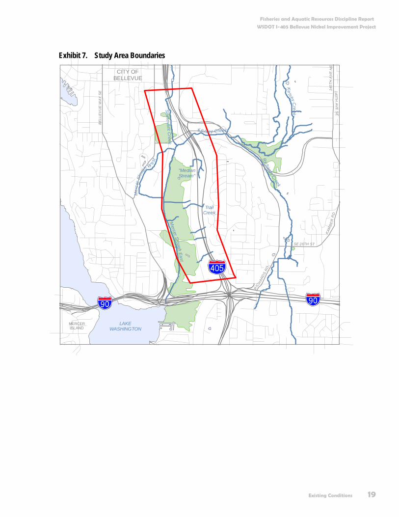
What is our study area and how did we determine it? The study area for the project encompassed the in-stream and associated riparian habitats of the streams and sloughs located up to 300 feet upstream (maximum distance anticipated for upstream effects) and 0.25 mile downstream of the highway ROW (maximum distance anticipated for effects due to both construction and future stormwater events [see Appendix C]). The study area occurs within the Cedar-Sammamish Watershed (Water Resource Inventory Area [WRIA] 8). Exhibit 7 shows the study area boundaries.
Watershed
A watershed is the region of land that drains into a specified body of water, such as a river, lake, sea, or ocean. Rainthat falls anywhere within a water body’s watershed will eventually drain into that body of water.
A watershed or catchment basin is the region of land that drains into a specified body of water, such as a river, lake, sea, or ocean. Rain that falls anywhere within a given body of water's watershed will eventually drain into that body of water.
Fish Passage Barrier
A physical barrier in a waterbody, either natural or human-made, that prohibits up- and/or downstream fish migration. Examples include culverts with steep gradients, natural waterfalls, or artificial or natural dams.
Substrate Composition and Classifications
Stream substrates (the types of gravel found on a stream bottom) influence the types of aquatic life that inhabit or use a particular stream or area of a stream. Sediments found in the streams of the study area were identified by the following stream size classes: Smooth or rough bedrock (larger than a car), boulder (basketball to car), cobble (tennis ball to basketball), coarse gravel (marble to tennis ball), fine gravel (ladybug to marble), sand (gritty- up toladybug size), silt/clay/muck (not gritty), hardpan (firm, consolidated fine substrates), and wood (any size).
Fisheries and Aquatic Resources Discipline Report
WSDOT I-405 Bellevue Nickel Improvement Project
Existing Conditions 19
Exhibit 7. Study Area Boundaries
CITY OFBELLEVUE
Mercer Sloug h East
St ur tevant Creek
Richards Creek
Mer
cer S
loug
h W
est
"MedianStream"
Ke
lsey Creek
TrailCreek
Kel sey Creek
LAKEWASHINGTON
MERCERISLAND
BE
LLE
VU
E W
AY S
E
RIC
HAR
DS
RD
140TH AV
E S
E
SE 26TH ST
KAM
BE
R R
D14
0TH
AV
E N
E

Fisheries and Aquatic Resources Discipline Report
WSDOT I-405 Bellevue Nickel Improvement Project
20 Existing Conditions
WRIA 8 is located predominantly within the borders of King County but 15 percent of it extends northward into Snohomish County. Puget Sound borders WRIA 8 to the west, while to the east, the headwaters of the Cedar River reach the crest of the Cascade Range near Stampede Pass. The northern and southern boundaries follow hilltops, ridges, and plateaus that define the drainage divides between the Snohomish/Snoqualmie Watershed (WRIA 7) and Green/Duwamish Watershed (WRIA 9), respectively.
What are the general habitat characteristics of the study area? The Kelsey Creek Basin is 10,870 acres in size and is composed of several streams, all of which drain westerly into Mercer Slough before entering the East Channel of Lake Washington at I-90. The tributaries of Lake Washington are among some of the most hydrologically altered streams in the Puget Sound Region. They are low-gradient streams, have a hydrology pattern generally dependent on rainfall and groundwater (not snowpack), and exist in heavily urbanized settings. The drainage basins associated with these streams generally have high amounts of impervious surfaces, altered hydrologic regimes, loss of floodplain connectivity, poor riparian conditions, and water quality problems (Kerwin 2001).
In general, residential, commercial, and industrial land uses have highly altered the streams in the Bellevue Nickel Improvement Project study area from their natural state. These alterations have included bank hardening, such as installing riprap; reducing or removing streamside vegetation; straightening stream channels; placing streams in culverts; and removing in-stream habitat. These alterations have also resulted in loss of the historic floodplains associated with most of these waterbodies. The vegetation surrounding these waterbodies has also changed. A mix of immature native vegetation and non-native invasive plant species has replaced what was once predominantly mature native vegetation.
The streams and sloughs within the study area include Kelsey Creek, Sturtevant Creek, Trail Creek, Mercer Slough, and
Water Resource Inventory Area (WRIA)
Washington State is divided into 62 WRIAs for water and aquatic resource management issues. A WRIA may include more than one watershed. However, the terms "WRIA" and "watershed" are frequently used interchangeably.
Non-Native Invasive Plant Species
Non-native invasive plant species are plant species that do not naturally growin a particular area but thrive once introduced to that area. These plants are characteristically adaptable, aggressive, and have a high reproductive capacity. Their vigor, combined with a lack of natural enemies, often leads to outbreak populations.
Fisheries and Aquatic Resources Discipline Report
WSDOT I-405 Bellevue Nickel Improvement Project
Existing Conditions 21
several unnamed tributaries to the Mercer Slough wetlands. We describe the habitat found in the portions of these waterbodies that are within the study area in further detail below. For more information on the waterbodies themselves, see the Surface Water, Floodplains, and Water Quality Discipline Report for this project.
What fish and aquatic species occur in the study area? Many fish and other aquatic species inhabit the streams, sloughs, and wetlands in the study area. The types of species found in these different waterbodies vary greatly depending on the type, size, and quality of the waterbody and connectivity to other waterbodies. Fish species found in the area include both anadromous and resident salmonids, and a variety of other resident fish. Other aquatic species found in the area include micro- and macroinvertebrates, lampreys, crayfish, amphibians, and freshwater mussels and clams.
Native species of salmonids that can be found in the study area include Chinook (Oncorhynchus tshawytscha), coho (O. kisutch), chum (O. keta) (Paulsen, pers. comm.), and sockeye (O. nerka) salmon, steelhead trout (O. mykiss) and sea-run cutthroat (O. clarki clarki). In addition, we know that resident rainbow and resident cutthroat trout (O. clarki) use the waterbodies in the study area. Use of the study area by bull trout (Salvelinus confluentus) and Dolly Varden (Salvelinus malma) has not been documented; however, the U.S. Fish and Wildlife Service (USFWS) has proposed Lake Washington and all of its accessible tributaries and lakes as foraging, migration, and overwintering habitat for bull trout.
Anadromous salmonid species primarily use the streams, wetlands, and sloughs in the study area for upstream and downstream migration and rearing. The study area also contains limited spawning habitat for Chinook, coho, chum, and steelhead. Resident cutthroat trout use the study area for all life stages.
Macroinvertebrate vs. Microinvertebrate
Macroinvertebrates are small animals without backbones, which are visible with the naked eye (insects, worms, larvae, etc.). Microinvertebrates are similar to macroinvertebrates but are not visible to the naked eye. Waterbodies have communities of aquatic macro- and microinvertebrates. The species composition, species diversity, and abundance of the macro- and microinvertebrates in a given waterbody can provide valuable information on the relative health and water quality of a waterway.
Anadromous vs. Resident Fish
Anadromous fish are born in freshwater streams, rivers, or lakes, spend their adult phase in the ocean, and return to their natal waters to spawn.
Resident fish spend their entire lives in freshwater systems and do not migrate into saltwater environments.
Fisheries and Aquatic Resources Discipline Report
WSDOT I-405 Bellevue Nickel Improvement Project
22 Existing Conditions
Other fish species likely to be found in the study area include three spine stickleback (Gasterosteus aculeatus), longnose dace (Rhinichthys cataractae), speckled dace (R. osculus), longfin smelt (Spirinchus thaleichthys), prickly sculpin (Cottus asper), riffle sculpin (C. gulosus), reticulated sculpin (Cottus perplexus), shorthead sculpin (C. confuses), torrent sculpin (C. rhotheus), largescale sucker (Catostomus macrocheilus), peamouth chub (Mylocheilus caurinus), bluegill (Lepomis macrochirus), redside shiner (Richardsonius balteatus), Pacific lamprey (Lampetra tridentate), river lamprey (L. ayresi), and western brook lamprey (L. richardsoni).
Other native aquatic species found in the study area include several species of crayfish, frogs, salamanders, freshwater clams, and mussels.
Do any federally listed aquatic species or federal aquatic species of concern occur in the study area? Several of the streams and sloughs in the study area contain various life stages of Chinook salmon, and may contain bull trout and Dolly Varden (hereafter referenced synonymously with bull trout), all of which are currently listed as threatened under the ESA.
Waterbodies in the study area that Chinook salmon use include Kelsey Creek and Mercer Slough. Chinook salmon use the study area primarily for up- and downstream migration and rearing; however, there is also some limited spawning habitat in Kelsey Creek. The Chinook salmon found in these waterbodies are a part of the Puget Sound evolutionarily significant unit (ESU) of Chinook salmon, listed as threatened under the ESA (NMFS [National Marine Fisheries Service]1998 and 1999). An ESU is a distinctive population segment that is treated as an individual species under ESA
On December 14, 2004, the NMFS published proposed rules for designating critical habitat for 13 ESUs of Pacific salmon and steelhead in Washington, Oregon, and Idaho. This designation includes the Puget Sound ESU of Chinook salmon, which the
Evolutionarily Significant Unit (ESU)
An ESU of a fish species is the term used by NMFS for the population protected by a listing under the ESA.
Endangered Species Act (ESA)
An Act of Congress passed in 1973 that governs how we will protect and recover animal and plant species whose populations are dangerously in decline or close to extinction.
Fisheries and Aquatic Resources Discipline Report
WSDOT I-405 Bellevue Nickel Improvement Project
Existing Conditions 23
ESA currently lists as threatened. We designate critical habitat for areas containing the physical and biological habitat features, or primary constituent elements (PCEs), essential for the conservation of the species or which require special management considerations. PCEs include sites that are essential to supporting one or more life stages of the ESU and which contain physical or biological features essential to the conservation of the ESU. Proposed Chinook salmon critical habitat within the study area includes Kelsey Creek and Mercer Slough.
The Lake Washington system contains important foraging, migration, and overwintering habitat necessary for bull trout recovery (USFWS 2004). Mercer Slough connects directly to Lake Washington and also provides foraging, migration, and overwintering habitat for bull trout.
On June 25, 2004, USFWS published proposed rules for designating critical habitat for the Coastal Puget Sound population of bull trout, which appeared among the list of threatened species in 1999 under the ESA. For an area to be included as critical habitat, it must provide one or more of the following functions for bull trout: spawning, rearing, foraging, or over-wintering habitat to support essential existing bull trout local populations; movement corridors necessary for maintaining essential migratory life history forms; or suitable habitat that is considered essential for recovering existing local populations that have declined or that need to be re-established to achieve recovery.
Coho salmon and Pacific and river lamprey, all federal species of concern under the ESA, occur in the waterbodies in the vicinity of the study area.
Do any state-listed or other state priority aquatic species occur in or around the study area? Priority fish and aquatic species include all state endangered, threatened, sensitive, or candidate species, and species of recreational, commercial, or tribal importance that are considered vulnerable. All fish species with state candidate status that occur
Primary Constituent Elements (PCEs)
Physical and/or biological habitat features needed for the survival and successful reproduction of a species.

Fisheries and Aquatic Resources Discipline Report
WSDOT I-405 Bellevue Nickel Improvement Project
24 Existing Conditions
in the study area also hold a federal designation and we have discussed them earlier in this report. No other state sensitive, threatened, or endangered fish species are known to occur within the study area. Other fish species designated as priority species that may occur within the study area include coho, chum, and sockeye salmon; steelhead trout; and coastal cutthroat trout (WDFW [Washington State Department of Fish and Wildlife] 2004). We have included these state-listed priority species in this report for informational purposes only.
What are the habitat characteristics of the streams located in the study area? We collected information on the streams in the study area from a combination of existing information, including literature reviews and personal interviews, and from in-stream habitat surveys. The habitat characteristics for the waterbodies listed below are specific to those portions of the waterbodies located within the proximity of the project footprint (300 feet upstream to 0.25 mile downstream of the study area).
The format used to identify unnamed streams is as follows: 0A.BC-x.x, where A represents the WRIA number; BC indicates the initials of the receiving water body (the water body to which the stream is a tributary); and x.x is the approximate I-405 milepost (MP) (to the nearest tenth of a mile) for the anticipated crossing of the stream at I-405. For example, Stream 08.LW-7.8 is in WRIA 8, is an independent tributary to Lake Washington, and is expected to cross I-405 at approximately MP 7.8.
Unnamed Tributaries to Mercer Slough Wetlands Three unnamed tributaries to the Mercer Slough wetlands are located to the west of both the project footprint and the BNSF ROW. None of the downstream sections of these streams are immediately adjacent to the project footprint; however, some of them receive stormwater runoff from I-405. We describe the individual unnamed streams in further detail below.
Habitat Characteristics
The habitat characteristics of a waterbody are the features that provide habitat for the organisms that use it. Habitat characteristics include items such as stream slope, in-stream habitat type (e.g., pools and riffles), substrate, streamside vegetation, fish cover (places where fish can hide from predators), and amount of large woody debris (LWD) found in the stream.

Fisheries and Aquatic Resources Discipline Report
WSDOT I-405 Bellevue Nickel Improvement Project
Existing Conditions 25
First Unnamed Tributary to Mercer Slough Wetlands (08.MS-11.5) The first unnamed tributary to the Mercer Slough wetlands originates from a natural depression located on the east side of the I-405 northbound noise barrier. No distinct drainage channel exists in the depression and we did not see any evidence of flowing water during our two separate site visits. The depression collects surface stormwater and directs it through a series of culverts under I-405 and the BNSF ROW to an open stream channel bounded on the north by the BNSF ROW, the south by 118th Avenue SE, and the east and west by residential developments. After the tributary passes under 118th Avenue SE, it flows for approximately 50 feet in an open stream channel located in the Mercer Slough Nature Park to where the stream channel ends and the water flows into the ground. There is no distinct stream channel beyond this point.
The open channel section of the first unnamed tributary between the BNSF ROW and 118th Avenue SE is approximately 175 feet long with an average slope of approximately 8 percent. Riffles are the predominant in-stream habitat type in this reach, though the upstream end of the creek flows through a wetland for approximately 40 feet before flowing into a defined stream channel. Available fish cover includes overhanging vegetation within 3 feet of the water surface, macrophytes, small wood and brush, and LWD. The upper canopy of this section of creek is a mix of large and small deciduous and coniferous trees. Native shrubs and ferns dominate the shrub layer and some Himalayan blackberry (Rubus armeniacus) is present. The groundcover layer is primarily bare earth and duff but also contains some ferns and blackberries. The dominant streambed substrate is fine sediment. LWD in this reach consists of eight pieces both located within and bridged above the stream channel. This stream segment does not presently receive runoff from I-405, nor will the project direct stormwater into this stream.
Second Unnamed Tributary to Mercer Slough Wetlands (08.MS-11.7) The second unnamed tributary originates from a residential drainage system and an intermittent stream channel both located to the east of the project footprint. Flow travels through a series of culverts under I-405, the BNSF ROW, and 118th Avenue SE to a stormwater pond on the west side of 118th Avenue SE. This pond outlets to the Mercer Slough Nature Park.
Large vs. Small Trees
Large trees are those trees that are 12 inches or more in diameter at breast height (dbh). Small trees are those that are less than 12 inches dbh.
Duff
The partially decomposed organic matter (litter of leaves, flowers, and fruits) found beneath plants, as on a forest floor.
Typical stream channel of the first unnamed tributary to Mercer Slough wetlands
Fisheries and Aquatic Resources Discipline Report
WSDOT I-405 Bellevue Nickel Improvement Project
26 Existing Conditions
This stream segment does not presently receive runoff from I-405, nor will the project direct stormwater into this stream.
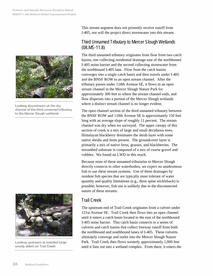
Third Unnamed Tributary to Mercer Slough Wetlands (08.MS-11.8) The third unnamed tributary originates from flow from two catch basins, one collecting residential drainage east of the northbound I-405 noise barrier and the second collecting stormwater from the northbound I-405 lane. Flow from the catch basins converges into a single catch basin and then travels under I-405 and the BNSF ROW to an open stream channel. After the tributary passes under 118th Avenue SE, it flows in an open stream channel in the Mercer Slough Nature Park for approximately 300 feet to where the stream channel ends, and flow disperses into a portion of the Mercer Slough wetlands where a distinct stream channel is no longer evident.
The open channel section of the third unnamed tributary between the BNSF ROW and 118th Avenue SE is approximately 150 feet long with an average slope of roughly 11 percent. The stream channel was dry when we surveyed. The upper canopy of this section of creek is a mix of large and small deciduous trees. Himalayan blackberry dominates the shrub layer with some native shrubs and ferns present. The groundcover layer is primarily a mix of native ferns, grasses, and blackberries. The streambed substrate is composed of a mix of coarse gravel and cobbles. We found no LWD in this reach.
Because none of these unnamed tributaries to Mercer Slough directly connects to other waterbodies, we expect no anadromous fish to use these stream systems. Use of these drainages by resident fish species that are typically more tolerant of water quantity and quality limitations (e.g., three spine stickleback) is possible; however, fish use is unlikely due to the disconnected nature of these streams.
Trail Creek The upstream end of Trail Creek originates from a culvert under 121st Avenue SE. Trail Creek then flows into an open channel until it enters a catch basin located to the east of the northbound I-405 noise barrier. This catch basin connects to a series of culverts and catch basins that collect freeway runoff from both the northbound and southbound lanes of I-405. These culverts ultimately converge and outlet into the Mercer Slough Nature Park. Trail Creek then flows westerly approximately 1,000 feet until it fans out into a wetland complex. From there, it enters the
Looking upstream at installed large woody debris on Trail Creek
Looking downstream at the dry channel of the third unnamed tributary to the Mercer Slough wetlands
Fisheries and Aquatic Resources Discipline Report
WSDOT I-405 Bellevue Nickel Improvement Project
Existing Conditions 27
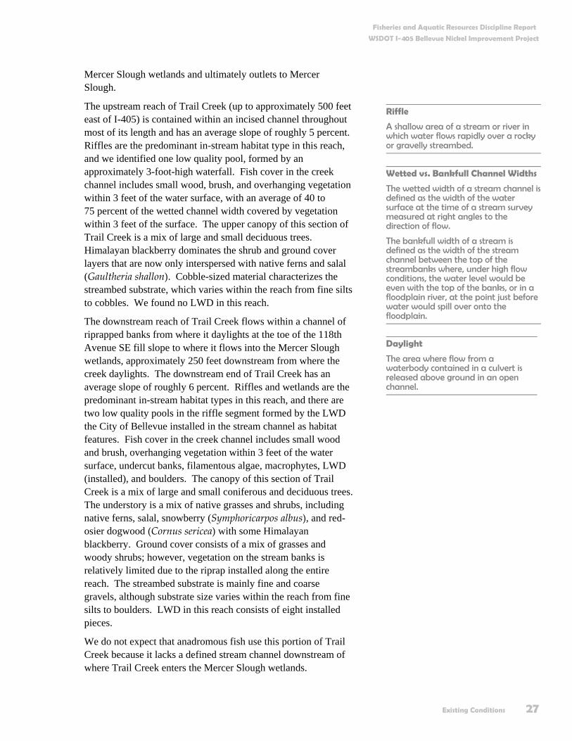
Mercer Slough wetlands and ultimately outlets to Mercer Slough.
The upstream reach of Trail Creek (up to approximately 500 feet east of I-405) is contained within an incised channel throughout most of its length and has an average slope of roughly 5 percent. Riffles are the predominant in-stream habitat type in this reach, and we identified one low quality pool, formed by an approximately 3-foot-high waterfall. Fish cover in the creek channel includes small wood, brush, and overhanging vegetation within 3 feet of the water surface, with an average of 40 to 75 percent of the wetted channel width covered by vegetation within 3 feet of the surface. The upper canopy of this section of Trail Creek is a mix of large and small deciduous trees. Himalayan blackberry dominates the shrub and ground cover layers that are now only interspersed with native ferns and salal (Gaultheria shallon). Cobble-sized material characterizes the streambed substrate, which varies within the reach from fine silts to cobbles. We found no LWD in this reach.
The downstream reach of Trail Creek flows within a channel of riprapped banks from where it daylights at the toe of the 118th Avenue SE fill slope to where it flows into the Mercer Slough wetlands, approximately 250 feet downstream from where the creek daylights. The downstream end of Trail Creek has an average slope of roughly 6 percent. Riffles and wetlands are the predominant in-stream habitat types in this reach, and there are two low quality pools in the riffle segment formed by the LWD the City of Bellevue installed in the stream channel as habitat features. Fish cover in the creek channel includes small wood and brush, overhanging vegetation within 3 feet of the water surface, undercut banks, filamentous algae, macrophytes, LWD (installed), and boulders. The canopy of this section of Trail Creek is a mix of large and small coniferous and deciduous trees. The understory is a mix of native grasses and shrubs, including native ferns, salal, snowberry (Symphoricarpos albus), and red-osier dogwood (Cornus sericea) with some Himalayan blackberry. Ground cover consists of a mix of grasses and woody shrubs; however, vegetation on the stream banks is relatively limited due to the riprap installed along the entire reach. The streambed substrate is mainly fine and coarse gravels, although substrate size varies within the reach from fine silts to boulders. LWD in this reach consists of eight installed pieces.
We do not expect that anadromous fish use this portion of Trail Creek because it lacks a defined stream channel downstream of where Trail Creek enters the Mercer Slough wetlands.
Daylight
The area where flow from a waterbody contained in a culvert is released above ground in an open channel.
Riffle
A shallow area of a stream or river in which water flows rapidly over a rocky or gravelly streambed.
Wetted vs. Bankfull Channel Widths
The wetted width of a stream channel isdefined as the width of the water surface at the time of a stream survey measured at right angles to the direction of flow.
The bankfull width of a stream is defined as the width of the stream channel between the top of the streambanks where, under high flow conditions, the water level would be even with the top of the banks, or in a floodplain river, at the point just before water would spill over onto the floodplain.
Fisheries and Aquatic Resources Discipline Report
WSDOT I-405 Bellevue Nickel Improvement Project
28 Existing Conditions
Based on known distributions, resident fish species that could occur in Trail Creek include cutthroat and rainbow trout, sculpins, and longnose and speckled dace (Wydoski and Whitney 1979).
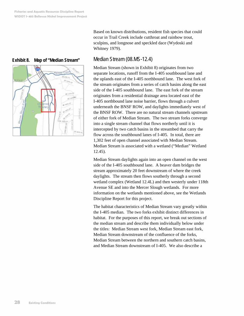
Median Stream (08.MS-12.4) Median Stream (shown in Exhibit 8) originates from two separate locations, runoff from the I-405 southbound lane and the uplands east of the I-405 northbound lane. The west fork of the stream originates from a series of catch basins along the east side of the I-405 southbound lane. The east fork of the stream originates from a residential drainage area located east of the I-405 northbound lane noise barrier, flows through a culvert underneath the BNSF ROW, and daylights immediately west of the BNSF ROW. There are no natural stream channels upstream of either fork of Median Stream. The two stream forks converge into a single stream channel that flows northerly until it is intercepted by two catch basins in the streambed that carry the flow across the southbound lanes of I-405. In total, there are 1,302 feet of open channel associated with Median Stream. Median Stream is associated with a wetland (“Median” Wetland 12.45).
Median Stream daylights again into an open channel on the west side of the I-405 southbound lane. A beaver dam bridges the stream approximately 20 feet downstream of where the creek daylights. The stream then flows southerly through a second wetland complex (Wetland 12.4L) and then westerly under 118th Avenue SE and into the Mercer Slough wetlands. For more information on the wetlands mentioned above, see the Wetlands Discipline Report for this project.
The habitat characteristics of Median Stream vary greatly within the I-405 median. The two forks exhibit distinct differences in habitat. For the purposes of this report, we break out sections of the median stream and describe them individually below under the titles: Median Stream west fork, Median Stream east fork, Median Stream downstream of the confluence of the forks, Median Stream between the northern and southern catch basins, and Median Stream downstream of I-405. We also describe a
Exhibit 8. Map of “Median Stream”
Fisheries and Aquatic Resources Discipline Report
WSDOT I-405 Bellevue Nickel Improvement Project
Existing Conditions 29
second smaller stream originating from the seepage of Median Wetland 12.45 in this section.
Median Stream West Fork The west fork of Median Stream originates from a culvert located approximately 20 feet from the shoulder of I-405 southbound and flows northerly for roughly 300 feet to where it joins with the east fork. The west fork is contained within a straightened riprapped channel for its entire length and has an average slope of less than 1 percent. Riffles and glides are the only in-stream habitat types found in the west fork. Fish cover consists entirely of overhanging Himalayan blackberries located within 3 feet of the wetted channel that cover over 90 percent of the surface area of the west fork. Riparian vegetation varies greatly between the right and left banks. Vegetation along the left bank ranges in size from 10 to 20 feet in width from the wetted edge. Plants consist of Himalayan blackberry and upland grasses with a few scattered small deciduous trees, none higher than 20 feet. Vegetation on the right bank comprises a canopy layer of large and small deciduous and coniferous trees. The understory and groundcover layers are dominated by Himalayan blackberry and include a mix of native shrubs, ferns, and grasses. The streambed substrate is entirely composed of fine sediments. We found only one piece of LWD, bridged above the wetted channel
Median Stream East Fork The east fork of Median Stream originates from a culvert located in the fill slope of the BNSF ROW and flows northwesterly for about 140 feet to where it joins with the west fork. The downstream-most 50 feet of the east fork spread out into a small alluvial fan prior to the confluence of the forks. The east fork has an average slope of roughly 8 percent. Riffles are the only in-stream habitat type. Available fish cover consists of a mix of LWD, small wood and brush, boulders, and overhanging vegetation within 3 feet of the water surface. In total, 10 to 40 percent of the stream channel has some type of available fish cover. Riparian vegetation on the right bank of the creek consists of a deciduous canopy layer composed of large and small trees, an understory layer of native shrubs and ferns, and a groundcover layer of mostly bare soils and duff, but it also contains some small woody shrubs, ferns, and grasses. Riparian vegetation on the left bank of the stream consists of large and small deciduous and coniferous trees; an understory layer of immature coniferous and deciduous trees, native shrubs, and
Alluvial Fan
An alluvial fan is a fan- or wedge-shaped accumulation of silt, sand, gravel and boulders deposited by rapidly flowing streams when they reach flatter terrain.
Glide
A section of stream that has little or no turbulence.
Fisheries and Aquatic Resources Discipline Report
WSDOT I-405 Bellevue Nickel Improvement Project
30 Existing Conditions
ferns; and a groundcover layer of mostly bare soils and duff, but it also contains some native small woody shrubs, ferns, and grasses. The streambed substrate is primarily coarse gravels and cobbles. The east fork has a small jam composed of five pieces of LWD and smaller wood.
Median Stream Downstream of the Confluence of the Forks The next section of Median Stream is the channel downstream of the confluence of the two forks and upstream of the southernmost catch basin in the streambed. This section is approximately 110 feet long, flows northerly in a straightened incised channel with riprapped, armored banks, and has an average slope of approximately 2.5 percent. Riffles are the only in-stream habitat type. Himalayan blackberry covers the majority of the stream within 3 feet of the water surface that provides almost complete fish cover through this reach. We also found additional fish cover (in the form of small woody debris and LWD) in the channel, and this assorted woody debris covered less than 10 percent of the total wetted channel. The streambed substrate is mainly sand and ranged in size from fine sediment to cobbles. We found several pieces of LWD within this reach, most of which were bridged above the bankfull channel.
Median Stream between the Northern and Southern Catch Basins The next section of Median Stream is the channel between the northern and southern catch basins located in the streambed. This section is approximately 250 feet long, flows in a straightened channel, and has an average slope of 0.5 to 1 percent. Riffles and glides are the predominant in-stream habitat types in this reach, and it contains one medium quality pool. Himalayan blackberry covers the majority of the stream channel and provides almost complete fish cover through this reach. Additional fish cover was also present in the channel in the form of small woody debris, which covered less than 10 percent of the total channel length. Fine sediment entirely comprises the streambed substrate. We did not find any LWD in this stream segment.
Median Stream Downstream of I-405 The downstream reach of Median Stream originates from a culvert on the west side of the fill slope of the southbound lane
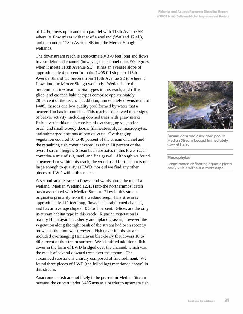
Typical stream channel in Median Stream between the northern and southern catch basins
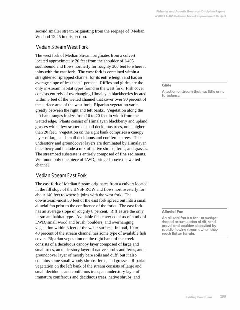
Looking downstream at the small alluvial fan at the confluence of the east and west forks of Median Stream
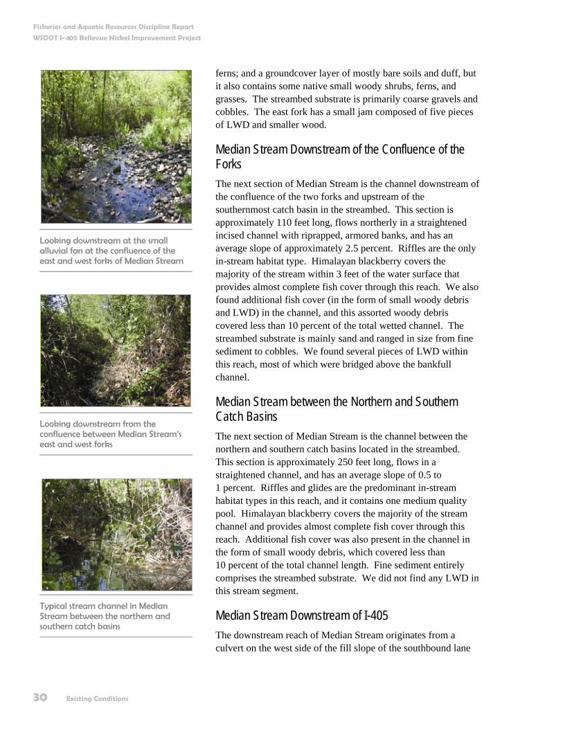
Looking downstream from the confluence between Median Stream’s east and west forks
Fisheries and Aquatic Resources Discipline Report
WSDOT I-405 Bellevue Nickel Improvement Project
Existing Conditions 31
of I-405, flows up to and then parallel with 118th Avenue SE where its flow mixes with that of a wetland (Wetland 12.4L), and then under 118th Avenue SE into the Mercer Slough wetlands.
The downstream reach is approximately 370 feet long and flows in a straightened channel (however, the channel turns 90 degrees when it meets 118th Avenue SE). It has an average slope of approximately 4 percent from the I-405 fill slope to 118th Avenue SE and 1.5 percent from 118th Avenue SE to where it flows into the Mercer Slough wetlands. Wetlands are the predominant in-stream habitat types in this reach, and riffle, glide, and cascade habitat types comprise approximately 20 percent of the reach. In addition, immediately downstream of I-405, there is one low quality pool formed by water that a beaver dam has impounded. This reach also showed other signs of beaver activity, including downed trees with gnaw marks. Fish cover in this reach consists of overhanging vegetation, brush and small woody debris, filamentous algae, macrophytes, and submerged portions of two culverts. Overhanging vegetation covered 10 to 40 percent of the stream channel and the remaining fish cover covered less than 10 percent of the overall stream length. Streambed substrates in this lower reach comprise a mix of silt, sand, and fine gravel. Although we found a beaver dam within this reach, the wood used for the dam is not large enough to qualify as LWD, nor did we find any other pieces of LWD within this reach.
A second smaller stream flows southwards along the toe of a wetland (Median Wetland 12.45) into the northernmost catch basin associated with Median Stream. Flow in this stream originates primarily from the wetland seep. This stream is approximately 110 feet long, flows in a straightened channel, and has an average slope of 0.5 to 1 percent. Glides are the only in-stream habitat type in this creek. Riparian vegetation is mainly Himalayan blackberry and upland grasses; however, the vegetation along the right bank of the stream had been recently mowed at the time we surveyed. Fish cover in this stream included overhanging Himalayan blackberry that covers 10 to 40 percent of the stream surface. We identified additional fish cover in the form of LWD bridged over the channel, which was the result of several downed trees over the stream. The streambed substrate is entirely composed of fine sediment. We found three pieces of LWD (the felled logs mentioned above) in this stream.
Anadromous fish are not likely to be present in Median Stream because the culvert under I-405 acts as a barrier to upstream fish
Beaver dam and associated pool in Median Stream located immediately west of I-405
Macrophytes
Large-rooted or floating aquatic plants easily visible without a microscope.

Fisheries and Aquatic Resources Discipline Report
WSDOT I-405 Bellevue Nickel Improvement Project
32 Existing Conditions
passage. Juvenile coho may be present downstream of I-405 and in Wetland 12.4L, due to their association with Mercer Slough. However, no direct connection has been documented between Mercer Slough and Median Stream.
Resident fish species could be present in Median Stream in the portion that is located in the I-405 median; however, resident fish species are likely to use the downstream reach of Median Stream due to its connection with Mercer Slough. Resident fish species likely to be present include cutthroat and rainbow trout, sculpins, Pacific lamprey, longnose dace, and speckled dace (Wydoski and Whitney 1979).
Kelsey Creek From the hillside to the east of I-405, Kelsey Creek flows westerly to where it enters a large culvert at the I-405 southbound off-ramp to SE 8th Avenue. Kelsey Creek then flows under I-405 and outlets into Mercer Slough via a culvert and associated fish ladder to the west of 118th Avenue SE (Exhibit 9). A second flood overflow culvert is located immediately north of the main channel culvert.
Kelsey Creek is currently on the Washington State Department of Ecology (Ecology) 303(d) list for exceeding allowable water quality criteria for fecal coliform bacteria and three pesticides (Dieldrin, Heptachlor Epoxide, and Dichloro-diphenyl-trichloroethane [DDT]).
We surveyed Kelsey Creek from the culvert at the I-405 southbound off-ramp to SE 8th Avenue upstream to the BNSF Wilburton Trestle. This reach of Kelsey Creek is approximately 300 feet long and has a slope of approximately 1 percent. Roadway and railroad infrastructure have necessitated channelization of the creek, and riprap armors most of the stream banks (both right and left bank). In-stream habitat types in this reach are a mix of riffle and pool habitats, including two high quality pools. Fish cover consists of overhanging vegetation, brush and small woody debris, boulders, and filamentous algae. Overhanging vegetation covered 10 to 40 percent of the stream channel and the remaining fish cover covered less than 10 percent of the wetted perimeter of the stream. The streambed substrate is mainly cobble-sized material, and sediments ranged
Exhibit 9. Map of Kelsey Creek
Looking upstream at Kelsey Creek main channel
Downstream end of culvert connecting Kelsey Creek with Mercer Slough via a fish ladder

Fisheries and Aquatic Resources Discipline Report
WSDOT I-405 Bellevue Nickel Improvement Project
Existing Conditions 33
in size from fine silt to boulders. We identified a total of nine pieces of LWD in this reach.
Anadromous fish species known to occur in Kelsey Creek include Chinook, coho, and sockeye salmon, and steelhead (King County Department of Natural Resources 2001).
Resident fish species known to occur in Kelsey Creek include cutthroat and rainbow trout, sculpins, Pacific lamprey, longnose dace, speckled dace, largescale sucker, and bluegill (Kerwin 2001).
Sturtevant Creek Sturtevant Creek originates from Lake Bellevue and flows into an open channel constrained between a parking lot for the Lake Bellevue businesses and the BNSF ROW. From there, Sturtevant Creek flows alternatively between open channel and culverted segments until it crosses under I-405 via two side-by-side concrete culverts. At this point, Sturtevant Creek daylights and flows southerly into a series of open channel segments broken up by culverted sections and one area where the creek flows underneath a building. Once past the building, Sturtevant Creek flows through a culvert under SE 6th Street to where it enters a large wetland complex associated with Mercer Slough. The creek then flows under SE 8th Avenue to its confluence with Mercer Slough (Exhibit 10). Sturtevant Creek will not be affected by the project because the northern limits of the project are south of where the creek crosses I-405.
We surveyed Sturtevant Creek from where it daylights immediately downstream of I-405 to where it crosses under SE 6th Street into the wetland complex. We did not survey Sturtevant Creek upstream of I-405 for two reasons: 1) from that point onwards, the main channel of Sturtevant Creek is in a culvert for more than 300 feet from the toe of the project footprint; and, 2) the I-405 cross-culvert and associated drainage infrastructure act as fish passage barriers to both up- and downstream migration.
The surveyed reach of Sturtevant Creek is approximately 1,400 feet long with an average slope of approximately 1 to
Exhibit 10. Map of Sturtevant Creek
Sturtevant Creek flowing under office complex

Fisheries and Aquatic Resources Discipline Report
WSDOT I-405 Bellevue Nickel Improvement Project
34 Existing Conditions
2 percent. Commercial development has necessitated channelization of the creek throughout this entire length, and riprap armors most of the stream banks (both right and left). Riffles and glides are the predominant in-stream habitat types in the creek, and we identified a total of eight pools. These pools were primarily a mix of medium and high quality pools, with one pool ranking as low quality. Fish cover consists of overhanging vegetation, filamentous algae, macrophytes, brush and small woody debris, undercut banks, boulders, and culverts. In total, fish cover exists in less than 10 percent of the overall stream length. Riparian vegetation is a mix of various landscaping trees, shrubs, and grasses. Native vegetation is virtually non-existent in the surveyed reach. The streambed substrate is mainly fine and coarse gravels, and sediments ranged in size from fine silt to boulders. We identified only one piece of LWD in the surveyed reach.
The only known anadromous fish species to occur in Sturtevant Creek is coho salmon (City of Bellevue Utilities Department 2002). Due to Sturtevant Creek’s connection with Mercer Slough, other salmonid species that may occur in Sturtevant Creek include steelhead and Chinook salmon.
Resident fish species that we expect to occur in Sturtevant Creek include cutthroat trout, lamprey, and sculpin. Resident fish species that may occur, based on their geographic distribution and habitat requirements, include longnose dace, speckled dace, largescale sucker, and three spine stickleback (Wydoski and Whitney 1979).
Mercer Slough and the Mercer Slough Wetlands Mercer Slough is the largest contiguous wetland (367 acres) connected to Lake Washington. Mercer Slough lies in a broad wetland receiving basin that drains south into Lake Washington (Exhibit 11). It was a shallow inlet of Lake Washington before lake levels were lowered. The major tributaries to Mercer Slough are Kelsey Creek, Richards Creek, Valley Creek, Sturtevant Creek, and Coal Creek.
Exhibit 11. Map of Mercer Slough

Fisheries and Aquatic Resources Discipline Report
WSDOT I-405 Bellevue Nickel Improvement Project
Existing Conditions 35
Mercer Slough is currently on Ecology’s 303(d) list for exceeding allowable water quality criteria for fecal coliform bacteria, dissolved oxygen, and pH.
Due to its connection with Lake Washington and the tributaries mentioned above, Mercer Slough provides habitat for a variety of fish and aquatic species. For the purposes of this report, we presume all fish species known to use Lake Washington are present in Mercer Slough.
Fish biologists have documented the anadromous fish species that occur in Lake Washington, including Chinook, coho, and sockeye salmon; and kokanee, steelhead, rainbow and coastal cutthroat trout (Kerwin 2001).
Resident fish species known to occur in Lake Washington include cutthroat and rainbow trout, sculpins, Pacific lamprey, longnose dace, speckled dace, largescale sucker, and bluegill (Wydoski and Whitney 1979).
Researchers have identified 24 non-native fish species in Lake Washington. Some of these species prey on juvenile salmon (e.g., smallmouth bass) while others are potential competitors with juvenile salmonids for food (Kerwin 2001).
We did not survey Mercer Slough for stream habitat values as part of this project because Mercer Slough is a wetland complex and the stream survey protocols that we used were not applicable to document habitat values in Mercer Slough. For more information on Mercer Slough, refer to the Wetlands Discipline Report for this project.
Traffic moving through the existing Wilburton Tunnel


Potential Effects 37
Potential Effects What methods did we use to evaluate potential effects on fisheries and aquatic resources? WSDOT evaluated the effects of the Bellevue Nickel Improvement Project on fisheries and aquatic resources by reviewing the existing information gathered for the study area and by assessing project design data and our construction practices. We then analyzed the information to identify fisheries and aquatic resource changes that were likely to occur as:
Temporary construction effects
Permanent effects from the built project
Effects that will be delayed or distant from the project
For the Build Alternative, we calculated effects from the project by overlaying the temporary construction and permanent project footprints onto a map detailing the streams in the study area. From this map, we determined the riparian habitat areas that the project will affect temporarily and permanently. In addition to these effects, we also evaluated effects that will be delayed or distant from the project (including long-term downstream effects from increases in stormwater quantity).
For the No Build Alternative, we reviewed our existing maintenance practices and stormwater facilities to determine existing built conditions. We then compared these conditions with existing fisheries and aquatic resource conditions in the
Typical roadside vegetation in the study area.

Fisheries and Aquatic Resources Discipline Report
WSDOT I-405 Bellevue Nickel Improvement Project
38 Potential Effects
study area to determine how existing built conditions will affect these resources into the future.
How will the project affect fisheries and aquatic resources? The Build Alternative will add new roadways and roadway structures (e.g., culverts) within or near stream habitats that support fish and other aquatic species within the study area. In addition, maintenance of existing facilities in the study area will continue.
Project elements that will directly affect fisheries and aquatic resources include:
Placing a presently open channel portion of Median Stream into a culvert to accommodate construction of a new I-405 southbound lane
Encroaching into the riparian buffer of Median Stream
No Build Alternative The No Build Alternative assumes that WSDOT will not build the project and that we will continue with routine safety improvements and ongoing maintenance activities in the study area. In this scenario, sloughs and streams would not experience any physical changes from construction activities; however, routine maintenance activities such as mowing or brushing may disturb riparian buffers. The amount of untreated stormwater entering these waterbodies from I-405 and local streets would remain unchanged. It is possible that emission-reducing improvements in automobiles or increases in traffic volumes could change the concentrations of pollutants and contaminants entering these streams. However, there is no means to accurately predict that such changes would occur.
The No Build Alternative would not increase existing impervious surface areas. Therefore, we assume that it would result in little change to existing water quality in, and water quantity flowing into, the streams in the study area. As there are no construction activities associated with this alternative, there would be no effects from construction of in-water structures or removal of riparian vegetation to accommodate construction activities. Existing fish passage barriers throughout the study area would remain. This alternative would not change existing

Fisheries and Aquatic Resources Discipline Report
WSDOT I-405 Bellevue Nickel Improvement Project
Potential Effects 39
effects on fish and other aquatic organisms and the habitats in which they live.
Build Alternative The Build Alternative could affect fish habitat when we construct overwater and in-stream, encroach within riparian buffer areas, and produce stormwater runoff. All of these could affect stream water quantity and quality and, in turn, affect fisheries and proposed critical habitat.
We will assess all culverts affected by the project to determine if they are barriers to up- or downstream fish passage. We will further assess culverts deemed to be fish passage barriers to determine if they require replacement or retrofitting as part of the project.
Overwater and In-Stream Construction Overwater and in-stream construction associated with the project will only directly affect Median Stream. Exhibit 12 provides a summary of the overwater and in-stream effects of the project. We do not discuss effects to the wetland (Median Wetland 12.45) associated with this tributary in this section. For further information on this wetland, see the Wetlands Discipline Report for this project.
At present, Median Stream flows in the I-405 median, crosses I-405 via a series of concrete culverts, flows to and alongside SE 118th Avenue, and outlets into the Mercer Slough wetlands. Under the Build Alternative, the I-405 southbound lane will be realigned to the east of the existing alignment, widened to accommodate an additional southbound lane, and will cover a substantial portion of Median Stream. This realignment will result in 10,942 square feet of the bankfull width of Median Stream (500 linear feet of stream channel) being permanently covered by new roadway. In total, only 3,883 square feet of stream (150 linear feet of stream channel) will remain in an open stream channel after construction. We will direct existing stream flow into a new culvert under the realigned roadway that will outlet on the west side of I-405 in the same location as it does presently.
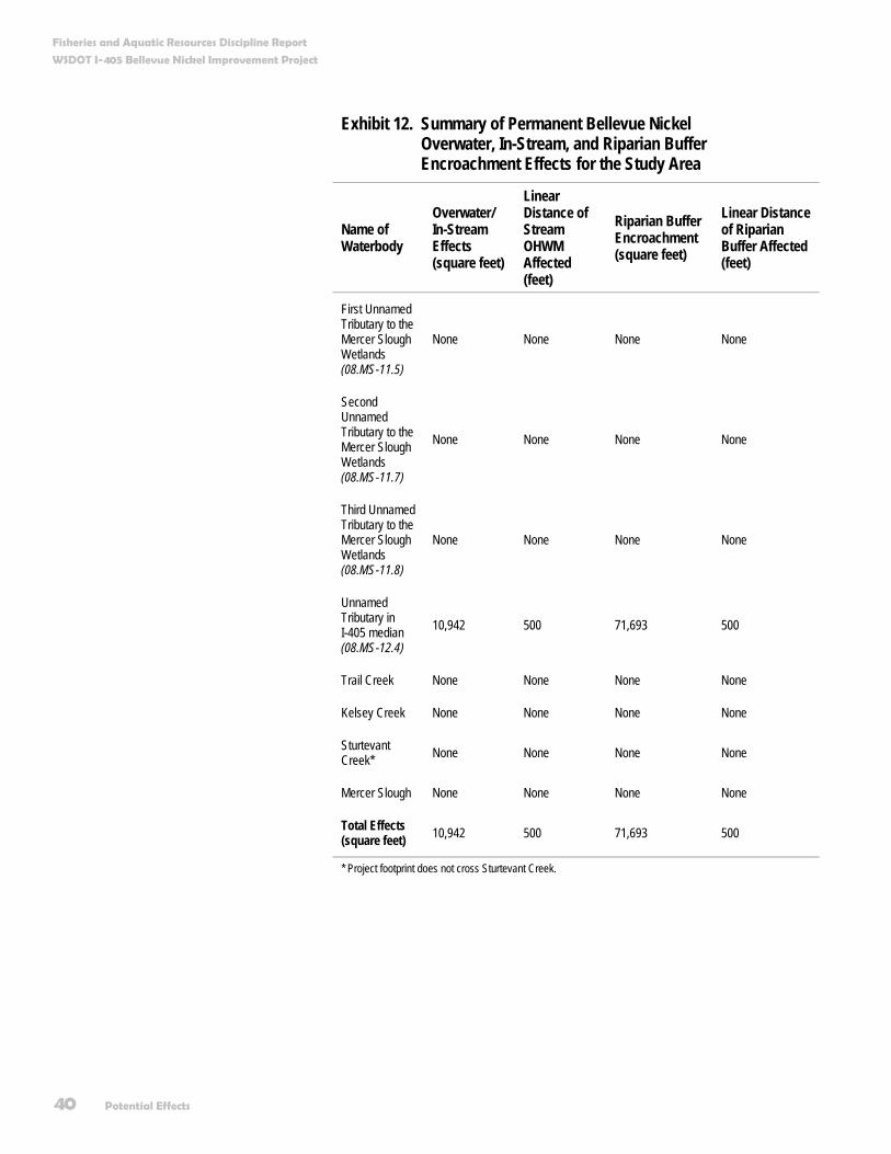
Fisheries and Aquatic Resources Discipline Report
WSDOT I-405 Bellevue Nickel Improvement Project
40 Potential Effects
Exhibit 12. Summary of Permanent Bellevue Nickel Overwater, In-Stream, and Riparian Buffer Encroachment Effects for the Study Area
Name of Waterbody
Overwater/ In-Stream Effects (square feet)
Linear Distance of Stream OHWM Affected (feet)
Riparian Buffer Encroachment (square feet)
Linear Distance of Riparian Buffer Affected (feet)
First Unnamed Tributary to the Mercer Slough Wetlands (08.MS-11.5)
None None None None
Second Unnamed Tributary to the Mercer Slough Wetlands (08.MS-11.7)
None None None None
Third Unnamed Tributary to the Mercer Slough Wetlands (08.MS-11.8)
None None None None
Unnamed Tributary in I-405 median (08.MS-12.4)
10,942 500 71,693 500
Trail Creek None None None None
Kelsey Creek None None None None
Sturtevant Creek* None None None None
Mercer Slough None None None None
Total Effects (square feet) 10,942 500 71,693 500
* Project footprint does not cross Sturtevant Creek.

Fisheries and Aquatic Resources Discipline Report
WSDOT I-405 Bellevue Nickel Improvement Project
Potential Effects 41
In total, this project will affect 10,942 square feet of in-stream habitat (500 linear feet of stream) within the ordinary high water mark (OHWM) of Median Stream. We discuss the riparian buffer encroachment resulting from the project in the next section.
Riparian Buffer Encroachment The project footprint will encroach into the riparian buffers of Median Stream. No other riparian buffer encroachment will occur as part of this project, as any other roadway expansions in the vicinity of a stream or slough will occur over existing impervious surface and will not disturb existing riparian buffers. Exhibits 12 and 13 detail effects to riparian buffers.
Exhibit 13. Summary of Bellevue Nickel Streams: Fish Use, Temporary Effects, and Permanent Effects for the Study Area
Name of Waterbody Fish Use (Known and Likely)
Temporary Effects (square feet)
Permanent Effects (square feet)
First Unnamed Tributary to the Mercer Slough Wetlands (08.MS-11.5)
Known: None Documented
Likely: Water quality tolerant species such as Three-Spined Stickleback could be present in this stream
None None
Second Unnamed Tributary to the Mercer Slough Wetlands (08.MS-11.7)
Known: None Documented
Likely: Water quality tolerant species such as Three-Spined Stickleback could be present in this stream
None None
Third Unnamed Tributary to the Mercer Slough Wetlands (08.MS-11.8)
Known: None Documented
Likely: Water quality tolerant species such as Three-Spined Stickleback could be present in this stream
None None
Unnamed Tributary in I-405 Median (08.MS-12.4)
Known: None documented
Likely: coho salmon, cutthroat and rainbow trout, sculpins, river and Pacific lamprey, and longnose and speckled dace
2,976 riparian buffer 670 within OHWM
71,693 riparian buffer 10,942 within OHWM
Ordinary High Water Mark
The elevation marking the highest water level which is maintained for a sufficient time to leave evidence upon the landscape, such as a clear, natural line impressed on the bank, changes in soil character, or the presence of litter and debris. Generally, it is the point where the natural vegetation changes from predominately aquatic to upland species.

Fisheries and Aquatic Resources Discipline Report
WSDOT I-405 Bellevue Nickel Improvement Project
42 Potential Effects
Name of Waterbody Fish Use (Known and Likely)
Temporary Effects (square feet)
Permanent Effects (square feet)
Trail Creek Known: None documented
Likely: Cutthroat and rainbow trout, sculpins, and longnose and speckled dace
None None
Kelsey Creek Known: Chinook, coho, and sockeye salmon; steelhead, cutthroat, and rainbow trout; sculpins; river and Pacific lamprey; longnose and speckled dace; largescale sucker; and bluegill
Likely: Other less common resident species or invasive species may use Kelsey Creek
None None
Sturtevant Creek Known: Coho salmon, lamprey, sculpin, cutthroat trout, and largescale sucker,
Likely: Chinook salmon, steelhead trout, longnose and speckled dace, and three spine stickleback
None None
Mercer Slough Known: Chinook, coho, and sockeye salmon; Kokanee, steelhead, rainbow, coastal cutthroat, and cutthroat trout; sculpins; river and Pacific lamprey; longnose and speckled dace; largescale sucker; and bluegill
Likely: Other less common resident species or invasive species may use Kelsey Creek
None None
In total, we will permanently remove 71,693 square feet of the riparian buffer of Median Stream (500 linear feet of riparian buffer). A significant portion of these buffer effects will occur on the stream’s left bank, which is composed mostly of Himalayan blackberry, upland grasses, and minimal, immature native deciduous trees.
The existing riparian condition of Median Stream is degraded. Therefore, many of the functions provided by riparian vegetation
Fisheries and Aquatic Resources Discipline Report
WSDOT I-405 Bellevue Nickel Improvement Project
Potential Effects 43
(such as LWD recruitment, contribution of organic material, fish cover, bank stabilization, and stream temperature regulation) are altered from natural conditions and will not be substantially affected as compared to existing conditions.
Stream Water Quantity The Bellevue Nickel Improvement Project will add approximately 10.3 acres of new impervious surface within the study area. This is approximately a 28 percent increase in impervious surface area over the existing impervious area associated with I-405.
Increases in stream water quantity resulting from storm events can negatively affect fish. Peak flows and sustained high flows in streams can harm or kill fish. Harm typically occurs when fish or other aquatic species are unable to get out of high flow areas and the current sweeps them downstream or batters them against rocks or streambanks. In urbanized streams where little to no refugia habitat exists and where stormwater events can cause rapid rises in stream levels, peak or sustained high flows can be especially detrimental to fish.
We expect to minimize negative effects on stream hydrology by the following practices:
WSDOT will provide runoff control from new impervious area to address changes in stormwater discharge to fish-bearing streams. We will design stormwater flow control facilities in accordance with the WSDOT Highway Runoff Manual (WSDOT 2004).
The WSDOT Highway Runoff Manual mandates that the duration and magnitude of stormwater discharge will generally match existing conditions for the range from 50 percent of the 2-year through to the 50-year recurrent storm events.
Existing stormwater facilities for I-405 in the study area are limited. A stormwater treatment pond in the I-405/SE 8th Street interchange will intercept stormwater from the new impervious surfaces associated with the project, and existing grass-lined ditches running parallel to I-405 will continue to provide limited water quality treatment. WSDOT will design the new
Refugia Habitat
An area of a stream that provides shelter or safety for aquatic species.
Peak Flow versus Base Flow
Peak flow refers to a specific period of time when the discharge of a stream or river is at its highest point. Base flow refers to the volume of flow in a stream or river during dry conditions, as opposed to conditions influenced by storm runoff.
Fisheries and Aquatic Resources Discipline Report
WSDOT I-405 Bellevue Nickel Improvement Project
44 Potential Effects
stormwater facilities to fully mitigate any flow effects that the new pavement will have on peak flows within the study area. Likewise, no negative effects to stream base flows, important for fish and downstream resources during summer low flows, are likely to occur from the increase in impervious surface (Black, pers. comm.).
Stream Water Quality As discussed above in the Stream Water Quantity section, existing stormwater facilities for I-405 in the study area are limited. Most stormwater from I-405 in the study area is untreated before it discharges into the streams or ditches in the study area. Under the Build Alternative, new storm drainage systems will collect runoff from an area equal to all new impervious surfacing created by the project. We will treat the stormwater runoff from this area before it is discharged into streams or sloughs. This treatment goes beyond the basic water quality goals for suspended solids removal by targeting dissolved pollutants such as copper and zinc that could be carried in the highway runoff.
Stormwater discharges to the streams and sloughs of the study area will comply with water quality regulations stipulated in WSDOT’s Highway Runoff Manual (WSDOT 2004). Therefore, we do not expect the water quality of stormwater discharge associated with the project to adversely affect aquatic life in the study area streams. For more information, see the Surface Water, Floodplains, and Water Quality Discipline Report for this project.
How will project construction affect fisheries and aquatic resources? Project construction will have several temporary effects on fisheries and aquatic resources. These temporary effects, discussed in the sections below, primarily relate to in-water construction, stream diversions, and changes to stream buffer and riparian vegetation, which can cause in-stream sedimentation.

Fisheries and Aquatic Resources Discipline Report
WSDOT I-405 Bellevue Nickel Improvement Project
Potential Effects 45
Direct Disturbance and Stream Diversions Construction activities over, in, or near a stream can disturb fish, other aquatic species, and aquatic habitat. Except where absolutely necessary (as in the case of culvert replacements or extensions), construction equipment will not enter streams below the OHWM and streams will be dewatered prior to placing new or lengthening existing culverts. Dewatering and stream diversions could strand or entrain (draw in) fish and create temporary barriers to fish movement.
WSDOT will minimize or eliminate fish stranding by adhering to WSDOT policy, which incorporates NMFS’ protocols (i.e., for fish exclusion and handling). Prior to commencing in-water work, all fish will be excluded (e.g., with a cofferdam) and removed from the work area with appropriate methods (e.g., electrofishing). Dewatering will occur during the driest time of the year when fish presence is least likely. We will limit in-water construction to approved work windows per permit conditions, and we will complete it in the shortest time possible. These measures should minimize any adverse effects to fish and other aquatic species during project construction.
In-Stream Sedimentation Constructing culvert extensions or replacements and retaining walls, as well as stormwater facility discharges could introduce fine sediments into the study area streams through runoff and erosion. Excessive fine sediment input into streams could cause fish eggs in the gravel to become smothered and unable to receive enough oxygen to survive, decrease micro- and macroinvertebrate survival that will limit available food for fish, and create conditions where visual predators, such as coho salmon, have reduced capacity to capture prey. In addition, certain types of sediments can cause damage to the gills of fish, increasing the risk of anoxia and stress that can lead to fish death (Lake and Hinch 1999).
The potential for erosion and sedimentation will be highest in Median Stream, where construction activities will occur within and directly adjacent to the stream. We will address potential effects from sedimentation by the following measures:
Cofferdam
A temporary dam-like structure constructed around a work site to exclude water.
Work Window
A defined time within which construction can be completed. Work windows are usually enforced by various permitting agencies.
Anoxia
The absence or reduced supply of oxygen in arterial blood or tissues.
Dewatering
Refers to using a system of pumps, pipes, or temporary holding dams to drain or divert waterways or wetlands before excavating soils and sediments orbuilding structures. Dewatering is used to reduce direct effects from in-water or overwater construction activities.
Electrofishing
An in-water fish-sampling method that involves capturing fish using an electric shock technique.
Fisheries and Aquatic Resources Discipline Report
WSDOT I-405 Bellevue Nickel Improvement Project
46 Potential Effects
Avoidance and Minimization – The project will use retaining walls to minimize effects to streams, wetlands, and other critical areas.
Construction Methods – WSDOT will dewater streams prior to replacing or lengthening culverts. WSDOT will strictly follow all conditions stipulated in the applicable permits and approvals.
Temporary Erosion and Sediment Control (TESC) Plan – WSDOT will develop a TESC before initiating construction of the project. WSDOT will implement the TESC Plan throughout all phases of construction.
Prevention – Appropriate BMPs (as outlined in the Measures to Avoid or Minimize Potential Effects section of this report and Appendix A) will reduce the risk of erosion and reduce or minimize opportunities for sediment to enter waterbodies in the vicinity of the project. WSDOT will properly implement, monitor, and maintain erosion and sediment control BMPs during construction to prevent long-term water quality effects. Even with BMPs, short-term effects to water quality from sediment (such as temporary increases in stream turbidity) are possible, particularly during storm events. However, we expect that these effects will be small in magnitude and not likely to cause harm to fisheries and aquatic resources in the study area.
Stream Buffer and Riparian Vegetation The project construction footprint extends a maximum of 10 feet beyond any new permanent structures. Most construction-related activities will occur within these limits, with the exception of staging areas or other related off-site construction activities. We anticipate minimal additional temporary clearing, grubbing, or construction effects to riparian vegetation beyond the permanent effects to stream buffers and riparian vegetation described previously in this report. In total, we will permanently remove 71,693 square feet of stream buffer and riparian vegetation to build the project. In addition, we will temporarily disturb 2,976 additional square feet of stream buffer and riparian vegetation during project construction. We will replant all temporarily cleared or disturbed areas with appropriate native vegetation.
Fisheries and Aquatic Resources Discipline Report
WSDOT I-405 Bellevue Nickel Improvement Project
Potential Effects 47
Other Potential Construction Effects Other potential short-term effects from the project could include hazardous materials (for example, oil and gasoline), chemical contaminants, nutrients, or other materials entering the waterbodies in the study area. Control of hazardous materials is a standard provision in construction contracts and permits. BMPs will address this issue. To reduce potential spills of petroleum and hydraulic fluids in sensitive areas, vehicles will not be serviced and/or refueled within 100 feet of streams and wetlands. WSDOT will be required to submit a spill prevention and response plan prior to commencing work.
Construction noise that could disturb or displace fish could occur for relatively long periods (weeks to months) at any given stream crossing. The in-water work window, defined as that period during which there is the lowest probability for fish presence, will be specified in the applicable permits and approvals, and this will limit the potential noise effects to fish. Moreover, there will be no in-stream pile driving within the OHWM of the study area streams.
Some construction will likely occur during hours of darkness or reduced light. Therefore, artificial lighting will be required for some work areas. Lighting will illuminate only work areas and avoid direct illumination of the affected waterbodies, limiting effects to fish behavior.
How will the project affect federally listed species and federal species of concern? The federally listed aquatic species known or presumed to be in the study area are Chinook salmon and bull trout. Coho salmon are the only federal aquatic species of concern known to inhabit the study area. We know that Chinook and coho salmon use Mercer Slough and Kelsey Creek at various life stages. We are also aware that coho salmon use Sturtevant Creek. Though bull trout use in the study area is likely limited due to the lack of quality habitat for this species, the USFWS has designated Lake Washington and associated Mercer Slough, Sturtevant Creek, and Kelsey Creek as proposed bull trout critical habitat.
No in- or over-water construction related to this project will occur in Mercer Slough, Sturtevant Creek, or Kelsey Creek. We will use appropriate and available BMPs to limit effects from construction in the vicinity of these waterbodies.
Fisheries and Aquatic Resources Discipline Report
WSDOT I-405 Bellevue Nickel Improvement Project
48 Potential Effects
Did we consider potential cumulative effects for the Build and No Build Alternatives? Consistent with the I-405 Corridor Program Final EIS and the results of scoping for the Bellevue Nickel Improvement Project, WSDOT analyzed the cumulative effects for this discipline. The analysis appears in the Cumulative Effects Analysis Discipline Report for this project.

Measures to Avoid or Minimize Project Effects 49
Measures to Avoid or Minimize Project Effects What will we do to avoid or minimize potential negative effects on fish and other aquatic species or aquatic habitat? WSDOT designed the Build Alternative to minimize the permanent and temporary construction effects of the project by avoiding and minimizing negative effects to fish and other aquatic species and aquatic habitat. Where possible, the project design locates the new roadway and associated roadway structures away from existing fish habitat to prevent permanent habitat effects. In cases where avoidance was not possible, project design features minimized effects to aquatic habitat.
Throughout the study area, the project design includes retaining walls that limit direct effects to streams and stream buffers. Although existing runoff from the study area receives treatment only at the I-405/SE 8th interchange and along portions of the study area via grass-lined ditches, WSDOT will treat all stormwater runoff from new impervious surfacing for water quality, including enhanced treatment for suspended solids and metals.
Fisheries and Aquatic Resources Discipline Report
WSDOT I-405 Bellevue Nickel Improvement Project
50 Measures to Avoid or Minimize Project Effects
What will we do to minimize construction effects? In addition to the inherent project features detailed in the previous section and in Appendix A, WSDOT will minimize the effects from project construction by:
Restoring temporarily cleared areas to pre-construction grades and replanting the areas with appropriate native vegetation. Restoration areas include the temporary construction area surrounding the built project footprint and any staging areas used by WSDOT.
Using effective erosion control measures, such as filter-fabric fence, straw mulch, and plastic sheeting to prevent silt and soil from entering surface waters (including wetlands).
Hydroseeding all bare soil areas following grading.
Clearly identifying streams and stream buffers on the construction plans and in the field.
Defining clearing limits with orange barrier fencing wherever clearing occurs in or near critical areas.
Prohibiting waste and excess materials from disposal or storage below the OHWM.
Complying with Washington State’s surface water quality standards (Chapter 173-201A WAC), which specify a mixing zone beyond which water quality standards cannot be exceeded. Monitoring of water quality will occur during construction to ensure compliance with Ecology’s standards to protect fish and aquatic life.
Preparing a Spill Prevention, Control, and Countermeasures Plan (SPCC) for the project prior to beginning any construction, and maintaining a copy of the plan with any updates at the work site.
Containing excavated sediment in Baker tanks or other appropriate containers to avoid discharge to surface water, and transporting the contained sediments to an approved disposal site.
Curing concrete before contact with surface water as required by WAC 110-220-070(1)(g) to avoid increased pH that can occur when fresh concrete contacts water.

Fisheries and Aquatic Resources Discipline Report
WSDOT I-405 Bellevue Nickel Improvement Project
Measures to Avoid or Minimize Project Effects 51
Regularly checking items such as fuel hoses, oil drums, and oil and fuel transfer valves and fittings for drips or leaks to prevent spills into surface water.
How will the project compensate for unavoidable adverse effects to fish or aquatic habitat? We will compensate for unavoidable negative effects to fisheries and aquatic resources associated with construction of the Build Alternative. In cooperation with resource agencies, WSDOT will develop plans for habitat improvement, restoration, or creation to compensate for the unavoidable effects of the roadway widening. Specific stream and wetland mitigation plans will be included in the permit applications for the Bellevue Nickel Improvement Project.
In our permit application, we will address overwater, in-stream, and riparian buffer effects to satisfy the requirements of the local critical areas regulations, the Hydraulic Code, Section 401 and 404 of the Clean Water Act, as well as the ESA.

References 53
References Black, Alan. Personal communication. Washington State Department of Transportation, Project
Drainage Engineer. Personal conversation with Derek Koellmann, Fisheries Biologist, June 2005.
City of Bellevue Utilities Department. 2002. Sturtevant Creek Basin [Online] Available at: http://www.ci.bellevue.wa.us/departments/utilities/pdf/sturtevant2.pdf Accessed: February 2002.
———. 2003. Bellevue Critical Areas Update Streams Inventory [Online] Available at: http://www.cityofbellevue.org/departments/Development/pdf/CA_Streams%20Inventory.pdf Accessed: March 2003.
Kerwin, J. 2001. Salmon and Steelhead Habitat Limiting Factors Report for the Cedar – Sammamish Basin (Water Resource Inventory Area 8). Washington Conservation Commission. Olympia, WA.
King County Department of Natural Resources (KCDNR). 2001. Known Freshwater Distribution of Salmon and Trout Water Resource Inventory Area (WRIA) 8 Lake Washington/Cedar/Sammamish Watershed [Online] Available at: http://dnr.metrokc.gov/Wrias/8/fish-maps/distmap.htm Accessed on: July 10, 2001.
Lake, R.G. and S.G. Hinch. 1999. Acute effects of suspended sediment angularity on juvenile coho salmon. Canadian Journal of Fisheries and Aquatic Sciences 56:862-867.
National Marine Fisheries Service (NMFS). 1998. Endangered and threatened species: Proposed endangered status for two Chinook salmon ESUs and proposed threatened status for five Chinook salmon ESUs; proposed redefinition, threatened status, and revision of critical habitat for one Chinook salmon ESU; proposed designation of Chinook salmon critical habitat in California, Oregon, Washington, Idaho. Federal Register 63 (45): 11482-11520. (National Marine Fisheries Service). March 9, 1998.
Fisheries and Aquatic Resources Discipline Report
WSDOT I-405 Bellevue Nickel Improvement Project
54 References
———. 1999. Endangered and threatened species: threatened status for three Chinook salmon ESUs in Washington and Oregon, and Endangered status for one Chinook salmon ESU in Washington. Final Rule. Federal Register 63(56):14308-14328. (National Marine Fisheries Service). March 24, 1999.
Paulsen, Kit. Personal communication. Stream Scientist, City of Bellevue. Telephone conversation with Derek Koellmann, Fisheries Biologist, May 13, 2005.
U.S. Fish and Wildlife Service (USFWS). 2004. Draft Recovery Plan for the Coastal-Puget Sound Distinct Population Segment of Bull Trout (Salvelinus confluentus). Volume I (of II): Puget Sound Management Unit. Portland, OR. 389 + xvii pp.
Washington State Department of Fish and Wildlife (WDFW). 2004. Priority Species List: Vertebrates. [Online] Available at: http://wdfw.wa.gov/hab/phsvert.htm Accessed: April 2005.
Washington State Department of Transportation (WSDOT). 2004. Highway Runoff Manual (M 31-16).
Williams, W.R., R.M. Laramie, and J.J. Ames. 1975. A catalog of Washington streams and salmon utilization. Volume 1: Puget Sound Region. Washington Department of Fisheries.
Wydoski, R.S. and R.R. Whitney. 1979. Inland fishes of Washington. Univ. of Wash. Press, Seattle, WA.

Appendix A Avoidance and Minimization Measures


Appendix A A-1
Avoidance and Minimization Measures The following sections describe the established design and construction practices that WSDOT will include to avoid or minimize effects to the various environmental resources during both the construction and operation phases of the project.
Project Measures to Avoid or Minimize Effects During Construction Design elements, such as modifications to boundaries of areas that can be affected, have been incorporated into the project specifications, construction plans, and procedures, to help avoid or minimize most potential construction impacts. When appropriate, monitoring will be conducted to ensure that these design and construction measures are effective.
Measures for Geology, Soils, and Groundwater WSDOT will prepare and implement a Temporary Erosion and Sedimentation Control
(TESC) plan consisting of operational and structural measures to control the transport of sediment. Operational measures include removing mud and dirt from trucks before they leave the site, covering fill stockpiles or disturbed areas, and avoiding unnecessary vegetation clearing. Structural measures are temporary features used to reduce the transport of sediment, such as silt fences and sediment traps.
WSDOT will reduce degradation of moisture-sensitive soils by limiting major earthwork to the drier, late spring through early fall construction season; by maintaining proper surface drainage to avoid ponding of surface water or groundwater; by minimizing ground disturbance through limiting the use of heavy equipment, limiting turns, and/or not tracking directly on the subgrade; and by covering the final subgrade elevation with a working mat of crushed rock and/or geotextile for protection. Mixing a soil admix such as cement into the subgrade may also add strength and stabilize the ground.
WSDOT will determine acceptable limits for off-site construction-related ground vibration before construction begins and demonstrate that off-site ground vibrations are within the limits set for the project through the use of vibration-monitoring equipment.
WSDOT will identify areas subject to shaking from a large earthquake and will mitigate risks using ground modifications or other procedures identified in the WSDOT Geotechnical Design Manual.
WSDOT will implement construction procedures identified in the geotechnical investigation to maintain or enhance slope stability in areas potentially underlain by landslide-prone soils.
WSDOT will protect the Kelsey Creek aquifer from contamination by construction-related spills by development and implementation of BMPs and a Spill Prevention Control and

A-2 Appendix A
Countermeasures plan (SPCCP). The SPCC will specifically address fuel spills from vehicles and from spills of other chemicals commonly transported over I-405. Spill response equipment will be located at regular and specified intervals within the project area for minimizing countermeasure response times.
WSDOT will ensure only clean fill is imported and placed for the project and will require documentation for fill brought onto the site from the supplier certifying that the fill does not exceed Washington State soil cleanup standards. If documentation is not available, testing of imported fill soils will be required prior to placement. Suspect soils encountered during project construction will be tested and, where necessary, removed from the site and disposed of in accordance with Washington State regulations.
WSDOT will identify and develop staging areas for equipment repair and maintenance away from all drainage courses. Washout from concrete trucks will not be dumped into storm drains or onto soil or pavement that carries stormwater runoff. A wash down area for equipment and concrete trucks will be designated and the use of thinners and solvents to wash oil, grease, or similar substances from heavy machinery or machine parts will be prohibited.
WSDOT will obtain a NPDES (National Pollutant Discharge Elimination System) permit and will conduct a regular program of testing and lab work to ensure that water encountered during construction meets the water quality standards specified in the NPDES permit.
WSDOT will to meet the NPDES water quality standards prior to the discharge of the encountered water to a surface water body, such as Kelsey Creek. If necessary, water quality will be improved, such as by using sediment ponds to allow sediment to settle out prior to discharge.
If it is necessary to install seepage drains to control seepage for retaining walls and fill embankments, WSDOT will include special provisions in the design to discharge drain flow back into affected areas, including wetlands.
Measures for Water Quality In addition to measures for geology, soils, groundwater, and for hazardous materials that are protective of water quality, the following measures would be implemented for water quality.
WSDOT will identify and develop staging areas for equipment repair and maintenance away from all drainage courses.
Washout from concrete trucks will not be dumped into storm drains or onto soil or pavement that carries stormwater runoff.
Thinners and solvents will not be used to wash oil, grease, or similar substances from heavy machinery or machine parts.
WSDOT will designate a wash down area for equipment and concrete trucks.
Appendix A A-3
Measures for Wetlands WSDOT will protect, preserve, and enhance wetlands in the project area during the planning,
construction, and operation of transportation facilities and projects consistent with USDOT Order 5660.1A, Executive Order 11990, and Governor’s Executive Orders EO 89-10 and EO 90-04.
WSDOT’s project-level design and environmental review has included avoidance, minimization, restoration, and compensation of wetlands. WSDOT will implement these measures prior to or concurrent with adverse effects on wetlands, to reduce temporal losses of wetland functions.
WSDOT will follow guidance contained in the wetlands section of the WSDOT Environmental Procedures Manual (WSDOT 2004a), which outlines the issues and actions to be addressed prior to authorizing work that could affect wetlands.
WSDOT will use high-visibility fencing to clearly mark wetlands to be avoided in the construction area.
Measures for Upland Vegetation and Wildlife WSDOT will ensure mitigation measures established in the I-405 Corridor EIS will be
implemented on the Bellevue Nickel Improvement Project.
WSDOT will prepare and implement a revegetation plan. In addition, areas with mixed forest will not be removed for temporary use (i.e., construction staging). If an area of mixed forest must be removed for roadway construction, it will be replaced with plantings of native tree and shrub species within the affected area.
WSDOT will adhere to project conditions identified in the Biological Assessment and agency concurrence letters.
WSDOT will limit construction activity to a relatively small area immediately adjacent to the existing roadway to minimize vegetation clearing and leave as many trees as possible.
Measures for Fisheries and Aquatic Resources WSDOT will implement construction BMPs (such as silt fencing or sedimentation ponds) to
avoid disturbing sensitive areas during the development and use of any staging areas, access roads, and turnouts associated with resurfacing activities.
WSDOT will not allow in-water work to occur except during seasonal work windows established to protect fish.
WSDOT will require that all stormwater treatment wetland/detention facilities are sited and constructed at a sufficient distance from named and unnamed streams so no grading or filling in the streams or the streamside zones will be required.

A-4 Appendix A
Measures for Air Quality WSDOT will require preparation and implementation of a Fugitive Dust Control Plan in
accordance with the Memorandum of Agreement between WSDOT and PSCAA Regarding Control of Fugitive Dust from Construction Projects (October 1999).
During dry weather, exposed soil will be sprayed with water to reduce emissions of and deposition of particulate matter (PM10).
WSDOT will provide aequate freeboard (space from the top of the material to the top of the truck), cover truckloads, and, in dry weather, wet materials in trucks to reduce emission of and deposition of particulate matter during transport.
WSDOT use wheel washers to remove particulate matter that would otherwise be carried offsite by vehicles to decrease deposition of particulate matter on area roadways.
WSDOT will remove particulate matter deposited on public roads to reduce mud on area roadways.
WSDOT will cover or spray with water any dirt, gravel, and debris piles during periods of high wind when the stockpiles are not in use to control dust and transmissions of particulate matter.
WSDOT will route and schedule construction trucks to reduce travel delays and unnecessary fuel consumption during peak travel times, and therefore reduce secondary air quality impacts (i.e. emissions of carbon monoxide and nitrogen oxides) that result when vehicles slow down to wait for construction trucks.
Measures for Noise Noise berms and barriers will be erected prior to other construction activities to provide noise
shielding.
The noisiest construction activities, such as pile driving, will be limited to between 7 AM and 10 PM to reduce construction noise levels during sensitive nighttime hours.
Construction equipment engines will be equipped with adequate mufflers, intake silencers, and engine enclosures.
Construction equipment will be turned off during prolonged periods of nonuse to eliminate noise.
All equipment will be maintained appropriately and equipment operators will be trained in good practices to reduce noise levels.
Stationary equipment will be stored away from receiving properties to decrease noise.
Temporary noise barriers or curtains will be constructed around stationary equipment that must be located close to residences.
Resilient bed liners will be required in dump trucks to be loaded on site during nighttime hours.
Appendix A A-5
WSDOT use Occupational Safety and Health Administration (OSHA)-approved ambient sound-sensing backup alarms that would reduce disturbances during quieter periods.
Measures for Hazardous Materials
Known or Suspected Contamination within the Build Alternative Right of Way WSDOT will prepare an SPCCP that provides specific guidance for managing contaminated
media that may be encountered within the right of way (ROW).
WSDOT may be responsible for remediation and monitoring of any contaminated properties acquired for this project. WSDOT will further evaluate the identified properties before acquisition or construction occurs. Contamination in soils will be evaluated relative to the Model Toxics Control Act (MTCA).
If WSDOT encounters an underground storage tank (UST) within the ROW, WSDOT will assume cleanup liability for the appropriate decommissioning and removal of USTs. If this occurs, WSDOT will follow all applicable rules and regulations associated with UST removal activities.
WSDOT will conduct thorough asbestos-containing material/lead paint building surveys by an Asbestos Hazard Emergency Response Act (AHERA)-certified inspector on all property structures acquired or demolished. WSDOT will properly remove and dispose of all asbestos-containing material/lead-based paint in accordance with applicable rules and regulations.
Construction waste material such as concrete or other harmful materials will be disposed of at approved sites in accordance with Sections 2-01, 2-02, and 2-03 of the WSDOT Standard Specifications.
WSDOT may acquire the responsibility for cleanup of any soil or groundwater contamination encountered during construction (that must be removed from the project limits) within WSDOT ROW. Contamination will be evaluated relative to Model Toxics Control Act (MTCA) cleanup levels.
WSDOT will consider entering into pre-purchaser agreements for purpose of indemnifying itself against acquiring the responsibility for any long-term cleanup and monitoring costs.
All regulatory conditions imposed at contaminated properties (e.g., Consent Decree) associated with construction will be met. These conditions could include ensuring that the surrounding properties and population are not exposed to the contaminants on the site: i.e., WSDOT will ensure that the site is properly contained during construction so that contaminants do not migrate offsite, thereby protecting the health and safety of all on-site personnel during work at the site.
Known or Suspected Contamination Outside of the Right of Way Contaminated groundwater originating from properties located up-gradient of the ROW could
migrate to the project area. WSDOT generally will not incur liability for groundwater contamination that has migrated into the project footprint as long as the agency does not
A-6 Appendix A
acquire the source of the contamination. However, WSDOT will manage the contaminated media in accordance with all applicable rules and regulations.
Unknown Contamination If unknown contamination is discovered during construction, WSDOT will follow the SPCCP
as well as all appropriate regulations.
Worker and Public Health and Safety and other Regulatory Requirements The WSDOT will comply with the following regulations and agreements:
State Dangerous Waste Regulations (Chapter 173-303 WAC);
Safety Standards for Construction Work (Chapter 296-155 WAC);
National Emission Standards for Hazardous Air Pollutants (CFR, Title 40, Volume 5, Parts 61 to 71);
General Occupational Health Standards (Chapter 296-62 WAC); and
Implementing Agreement between Ecology and WSDOT Concerning Hazardous Waste Management (April 1993).
Hazardous Materials Spills During Construction WSDOT will prepare and implement a SPCCP to minimize or avoid effects on human health,
soil, surface water and groundwater.
Measures for Traffic and Transportation WSDOT will coordinate with local agencies and other projects to prepare and implement a
Traffic Management Plan (TMP) prior to making any changes to the traffic flow or lane closures. WSDOT willl inform the public, school districts, emergency service providers, and transit agencies of the changes ahead of time through a public information process. Pedestrian and bicycle circulation will be maintained as much as possible during construction.
Prior to and during construction, WSDOT will implement strategies to manage the demand on transportation infrastructure. These transportation demand management strategies will form an important part of the construction management program and will be aimed at increasing public awareness and participation in HOV travel. The major focus will be on expanding vanpooling and van-share opportunities. Other elements of the transportation demand management plan may include:
increased HOV awareness and public information, and
work-based support and incentives.

Appendix A A-7
Measures for Visual Quality WSDOT will follow the I-405 Urban Design Criteria. Where the local terrain and placement
of light poles allow, the WSDOT will reduce light and glare effects by shielding roadway lighting and using downcast lighting so light sources will not be directly visible from residential areas and local streets.
WSDOT will restore (revegetate) construction areas in phases rather than waiting for the entire project to be completed.
Measures for Neighborhoods, Businesses, Public Services and Utilities WSDOT will prepare and implement a transportation management plan (TMP). If local
streets must be temporarily closed during construction, WSDOT will provide detour routes clearly marked with signs.
WSDOT will coordinate with school districts before construction.
WSDOT will implement and coordinate the TMP with all emergency services prior to any construction activity.
WSDOT will coordinate with utility providers prior to construction to identify conflicts and resolve the conflicts prior to or during construction. Potential utility conflicts within WSDOT ROW will be relocated at the utility’s expense prior to contract award.
WSDOT will prepare a consolidated utility plan consisting of key elements such as existing locations, potential temporary locations and potential new locations for utilities; sequence and coordinated schedules for utility work; and detailed descriptions of any service disruptions. This plan will be reviewed by and discussed with affected utility providers prior to the start of construction.
WSDOT will field verify the exact locations and depths of underground utilities prior to construction.
WSDOT will notify neighborhoods of utility interruptions by providing a scheduled of construction activities in those areas.
WSDOT will coordinate with utility franchise holders and provide them with project schedules to minimize the effects of utility relocations (for example, equipment procurement times, relocation ahead of construction, etc.)
WSDOT will notify and coordinate with fire departments for water line relocations that may affect water supply for fire suppression, and establish alternative supply lines prior to any breaks in service; and to ensure that fire departments can handle all calls during construction periods and to alleviate the potential for increased response times.
WSDOT will notify and coordinate with police departments to implement crime prevention principles and to ensure that they have adequate staffing to provide traffic and pedestrian control.

A-8 Appendix A
WSDOT will maintain access to businesses throughout the construction period through careful planning of construction activities and an awareness of the needs to provide adjacent properties with reasonable access during business hours. As part of construction management, WSDOT will prepare access measures. WSDOTT will make provisions for posting appropriate signs to communicate the necessary information to potential customers.
WSDOT will keep daytime street closures to a minimum to provide access for businesses during regular business hours.
Measures for Cultural Resources WSDOT will prepare an Unanticipated Discovery Plan for the project that WSDOT will
follow. This will avoid or minimize unanticipated effects to historic, cultural, and archaeological resources.
Project Measures to Avoid or Minimize Effects During Project Operation The following sections describe the measures that WSDOT will implement during project operation.
Measures for Surface Waters and Water Quality WSDOT will follow the Highway Runoff Manual for both the design and implementation of
stormwater facilities. WSDOT is not required to manage flow where drainage is directly to Mercer Slough. Where drainage is to a tributary to Mercer Slough, WSDOT will construct a stormwater management system that does provide flow control.
Measures for Fisheries and Aquatic Resources WSDOT will compensate for adverse effects to fish habitat and aquatic resources by
providing in-kind mitigation. This in-kind mitigation will take the form of on-site, off-site, or a combination of on- and off-site mitigation.
Off-site mitigation could include planting native riparian vegetation outside of the study area in areas where restoring native riparian buffers may have a greater benefit to fish and aquatic species. Mitigation could be concentrated along streams with high fish use where important stream processes and functions related to riparian buffers (for example, large woody debris [LWD] recruitment levels, litter fall, and bank stabilization) are impaired.
On-site/off-site mitigation could include installing in-stream habitat features (for example, boulders or LWD) in the streambed downstream of the project footprint to increase the habitat complexity of the affected waterbody.

Appendix A A-9
Ongoing maintenance (during and post-construction) of stormwater treatment and detention facilities by WSDOT will not include the application of any chemical weed control agents (e.g., herbicides).
Measures for Upland Vegetation and Wildlife WSDOT will replace areas of mixed forest that will be permanently removed for roadway
construction with plantings of native tree and shrub species within the affected area.


Appendix B Memorandum from D. Koellmann to MAP and I-405 Teams Summarizing
Stream Survey Methodology

Appendix B B-1
To: I-405 Team
MAP Team
From: Derek Koellmann
Date: March 21, 2005
Re: Recommended Stream Survey Protocols
Overview
The I-405 Bellevue and Bellevue Improvement Project study areas cross or are located within the proximity of a variety of streams and rivers. As such, various elements of the projects have the potential to affect these waterbodies. To help determine the nature and extent of these effects, the habitat in these waterbodies must be assessed to quantitatively and qualitatively document in-stream and riparian conditions. This document describes the methodology that will be used to collect information on the physical characteristics of the streams and rivers in the study areas.
The specific habitat variables to be assessed in this study include the following:
• Existing stream geomorphology
• In-stream habitat type
• Riparian vegetation
• Substrate composition
• Abundance of large woody debris
• Quality of pools
The information collected will be used in conjunction with existing fisheries information (e.g., from existing reports and data, interviews) for the study areas to assess the quality and quantity of fish spawning, migration, and rearing habitat and provide information on the current and potential fish and other aquatic species use of the streams and rivers.
This methodology has been developed to document existing habitat in the study area in a manner that can be repeated so that future habitat conditions can be assessed post project construction.
Mercer Slough is located within the Bellevue study area, but it does not fall under the definition of a stream or river per this section, nor would the protocols recommended herein be appropriate to assess the habitat values in Mercer Slough. A separate method for documenting habitat values in Mercer Slough is proposed at the end of this memo.
B-2 Appendix B
Stream Survey Approach
Stream surveys will be performed on all streams and rivers that are crossed by I-405 and SR 167 or are located within the immediate proximity of the project area. The surveys will be conducted from approximately 300 feet upstream and 1,320 feet downstream (1/4 mile) of the proposed project footprint.
Up to 11 transects will be laid out perpendicular to stream flow at regularly spaced intervals along the streams to be surveyed. The minimum distance between transects will be 50 feet and the maximum distance will be 300 feet. The distance between transects will be based upon the bankfull width of the stream to be surveyed. For some streams that run parallel to I-405 or SR 167, such as Gilliam and Panther Creeks, two sets of transects may be established to ensure that habitat values throughout the stream reach are appropriately documented. Slightly different protocols will be used in wadeable versus non-wadeable streams and rivers.
At and in-between each transect qualitative and quantitative descriptions of in-stream and riparian habitat will be collected. A summary of the protocols to be used and habitat variables to be assessed is described further below. A field-training day is scheduled prior to initiating the full field effort. Some minor adjustments to the protocols may be needed based on this training. Protocol adjustments would be considered where applicable to improve the characterization of target parameters and/or to improve sampling efficiency.
Summary of Habitat Variables and Associated Protocols
The following protocols will be used to quantify the various habitat variables.
Existing Stream Geomorphology
Existing stream geomorphology information will be collected using protocols detailed in the U.S. Environmental Protection Agency’s (EPA) document Quantifying Physical Habitat in Wadeable Streams by Kaufmann et al. (1999) (Quantifying Physical Habitat).
Quantifying Physical Habitat details the concepts, rationale, and analytical procedures for characterizing physical habitat in wadeable streams based on raw data generated from methods similar or equal to those of Kaufmann and Robison (1998) that are used by the U.S. Environmental Protection Agency in its Environmental Monitoring and Assessment Program (EMAP). Guidance is provided for calculating measures or indices of stream size and gradient, sinuosity, substrate size, habitat complexity and cover, riparian vegetation cover and structure, and anthropogenic disturbances. Two-person crews typically complete EMAP habitat measurements in 1.5 to 3.5 hours of field time per sampling reach. While this time commitment is greater than that required for more qualitative methods, these more quantitative methods are more repeatable (i.e., more precise).
Variables to be surveyed using Quantifying Physical Habitat are listed below:
• Wetted width
• Bankfull width
• Bankfull height
• Stream depth
Appendix B B-3
• Reach Length
• Sinuosity of Reach
• Slope of Reach
• Bank angles
Existing Stream Geomorphology Metrics
• Mean and standard deviation (SD) of wetted width, bankfull width, bankfull height, stream depth, reach slope, and bank angles
• Reach Sinuosity
In-Stream Habitat Type
In-Stream Habitat Type will be quantified using the Timber Fish and Wildlife (TFW) Monitoring Program Method Manual for the Habitat Unit Survey by Pleus et al. (1999). (Habitat Unit Survey) and the EPA’s Rapid Bioassessment Protocols for Use in Streams and Rivers by Plafkin et al. (1989) (Bioassessment Protocols).
The Habitat Unit Survey provides methods for identifying habitat units, measuring their surface area, and collecting information on residual pool depth and pool-forming factors. Other information produced includes pool:riffle ratio, length of side channels, and the frequency distribution of residual pool depths and pool-forming factors.
The Bioassessment Protocols were originally developed in the 1980s to provide cost-effective, efficient biological survey techniques. The assessment is done using a visually based approach to characterizing the physical habitat structure of the stream site. The concepts underlying the Bioassessment Protocols are as follows:
• Cost-effective, scientifically valid procedures for biological surveys,
• Provisions for multiple site investigations in a field season,
• Quick turn-around of results for management decisions, and
• Scientific reports easily translated to management and the public.
Variables to be surveyed using the Habitat Unit Survey
• Stream Discharge
• Core Habitat Units (e.g. pool & riffle sequences)
• Surface Area Measurements of Core Habitat Units
• Residual Pool Depths
• Pool Forming Factors (e.g. LWD, boulder, etc)
Variables to be surveyed using Bioassessment Protocols
• Epifaunal substrate/available cover

B-4 Appendix B
• Channel Alteration (including armoring)
In-Stream Habitat Type Metrics
• Stream discharge (cfs)
• % of Core Habitat Units
• Habitat Units per Kilometer and Bankfull Width
• Pools per Kilometer
• Factors contributing to pool formation (PFF)
• % of units
• % of primary PFF
• % of pool surface area
• Mean and SD residual pool depth
• Mean and SD % epifaunal substrate/available cover
• % Altered channel
• % Streambank armoring
Riparian Vegetation
Riparian vegetation will be quantified using a combination of protocols from Quantifying Physical Habitat and Bioassessment Protocols.
Variables to be surveyed using Quantifying Physical Habitat
• Canopy Cover
• Riparian Vegetative Structure
Variables to be surveyed using Bioassessment Protocols
• Bank Stability
• Bank Vegetative Protection
• Riparian Vegetative Zone Width
Riparian Vegetation Metrics
• Mean and SD of canopy densiometer values
• % ground cover, mid layer vegetation cover, and canopy level cover, % total ground, mid layer vegetation, and canopy level cover, and % invasives
• Mean and SD % Bank Stability
• Mean and SD % Bank Vegetative Protection
Appendix B B-5
• Mean and SD % Riparian Vegetative Zone Width
Substrate Composition
Substrate composition information will be collected using protocols detailed in Quantifying Physical Habitat and Methods for Evaluating Riparian Habitats with Applications to Management by Platts et al. (1987) (Evaluating Riparian Habitats). For smaller stream segments where there is not adequate stream length to apply this method, a Wolman pebble count will be conducted to determine substrate composition. (Wolman 1954).
Evaluating Riparian Habitats is a comprehensive compilation of methods for resource specialists to use in managing, evaluating, and monitoring riparian conditions adjacent to streams, lakes, ponds, and reservoirs.
Variables to be surveyed using Quantifying Physical Habitat
• Substrate Size
• Substrate Composition
Variables to be surveyed using Evaluating Riparian Habitats
• Substrate Embeddedness (%) NOTE: In non-wadeable systems, such as the Green River, substrate sizes will be estimated either visually (where possible) or by using the drag method as prescribed by Lazorchak et al. (2000) in the Field Operations and Methods for Measuring the Ecological Condition of Non-Wadeable Rivers and Streams.
Substrate Composition Metrics
• Mean and SD of substrate size class
• 75th percentile of substrate size class
• Substrate median size class
• 25th percentile of substrate size class
• % breakdown of substrate size classes
• Mean and SD % embeddedness
Abundance of Large Woody Debris
Abundance of Large Woody Debris (LWD) will be quantified using the Level 1 survey method from the TFW Monitoring Program (LWD Method) method manual for the large woody debris survey by Schuett-Hames et al.(1999).
The LWD Method provides methods for documenting the number, volume and characteristics of large woody debris pieces in stream channels. The Level 1 survey involves a rapid tally of pieces by size category and produces information on total and key LWD pieces per channel width.
Variables to be surveyed using the LWD Method
• Number of LWD Pieces
B-6 Appendix B
• Identification of Key LWD Pieces
• Distribution of LWD in stream corridor
• LWD jam composition
Large Woody Debris Metrics
• % LWD pieces by size class and channel zone
• % key LWD pieces
• LWD pieces per channel width
• LWD pieces per kilometer
• LWD jam composition by % size class
Quality of Pools
Quality of Pools will be measured using methods described in Monitoring Protocols to Evaluate Water Quality Effects of Grazing Management on Western Rangeland Streams by Bauer and Burton (1993) (Water Quality Effects).
Water Quality Effects describes a monitoring system to assess grazing effects on water quality in streams of the western United States. The monitoring methods were selected for application by natural resource professionals with backgrounds in soils, range, hydrology, fisheries biology, and water quality. Though designed to be used in an agricultural environment, many of the protocols in this document (such as assessment of pool quality) can be applied over a broad geographic range.
Variables to be surveyed using the Water Quality Effects
• Pool depth (in conjunction with the Habitat Unit Survey)
• Substrate
• Overhead Cover
• Submerged Cover
• Bank Cover NOTE: The individual variables surveyed will be assimilated into a pool quality index that will detail habitat values for individual pools.
Quality of Pool Metrics
• Mean and SD pool quality index
Ordinary High Water Mark (OHWM)
OHWM measurements will be conducted in accordance with the protocols contained in A Guide for Field Identification of Bankfull Stage in the Western United States by the USDA, Forest Service, Stream Systems Technology Center Rocky Mountain Research Station.

Appendix B B-7
The OHWM for each stream will be marked for 60 lineal feet along the stream from the proposed toe of slope of impact line. In instances where the OHWM is located more than 60 lineal feet from the proposed toe of slope of impact line OHWM will not be marked and it will be documented in a technical memorandum that the distance to the OHWM exceeds 60 lineal feet.
Establishing Reference Points
A handheld GPS unit will be used to establish reference points at the upstream and downstream end of each surveyed stream reach to allow for future surveys to be conducted within the same reach.
Photographic Documentation
Photographs will be taken at the upstream end, downstream end, and mid-point of each survey reach. In addition, significant features (e.g. LWD jams, culvert outlets) will also be photographed.
Mercer Slough
Mercer Slough is a unique feature within the Bellevue study area. Several streams in the study area outlet into the slough; however, the slough itself is a lacustrine (lake influenced), rather than a riverine (river influenced) system. The slough is used by a variety of aquatic species and acts as a migration corridor and rearing area for salmonids in various life stages.
To assess the habitat values of Mercer Slough, habitat survey crews will determine the extent of inundated vegetated areas and deeper channel areas (those with no vegetation breaking the surface of the slough). A Differential Global Position System (DGPS) will be used to collect data along the outer margin of the wetted perimeter and deeper channel areas of Mercer Slough within the study area. This approach will provide information on the extent of the two main habitat types in Mercer Slough. A discussion of how these habitats could be affected by the project and/or used by fish could be prepared as part of the Bellevue Nickel Improvement Project Fisheries and Aquatic Resources Discipline Report. Existing information will be used to determine fish use in Mercer Slough.
B-8 Appendix B
References
A guide for field identification of bankfull stage in the western United States [videorecording] / producers, USDA Forest Service, Rocky Mountain Forest and Range Experiment Station, Stream Systems Technology Center; producer/director, Chris Frye.
Bauer, S. B., and Burton, T. A. 1993. Monitoring protocols to evaluate water quality effects of grazing management on western rangeland streams. United States Environmental Protection Agency, Water Division, Surface Water Branch, Region 10, Seattle, WA. pp. 145-148.
Kaufmann, P.R, P. Levine, E.G. Robison, C. Seeliger, and D.V. Peck. 1999.Quantifying Physical Habitat in Wadeable Streams. EPA/620/R-99/003. U.S.Environmental Protection Agency, Washington, D.C.
Lazorchak, J.M., Hill, B.H., Averill, D.K., D.V. Peck, and D.J. Klemm (editors). 2000. Environmental Monitoring and Assessment Program -Surface Waters: Field Operations and Methods for Measuring the Ecological Condition of Non-Wadeable Rivers and Streams U.S. Environmental Protection Agency, Cincinnati OH.
Plafkin, J.L., M.T. Barbour, K.D. Porter, S.K. Gross, and R.M. Hughes. 1989. Rapid bioassessment protocols for use in streams and rivers: Benthic macroinvertebrates and fish. U.S. Environmental Protection Agency, Office of Water Regulations and Standards, Washington, D.C. EPA 440-4-89-001.
Platts, W. S., C. Armour, G. D. Booth, M. Bryant, J. L. Bufford, P. Cuplin, S. Jensen, G. W. Lienkaemper, G. W. Minshall, S. B. Monsen, R. L. Nelson, J. R. Sedell, and J. S. Tuhy. 1987. Methods for evaluating riparian habitats with applications to management. USDA Forest Service General Technical Report INT-221. Intermountain Research Station, Ogden, UT. 187 pp.
Pleus, A.E., D. Schuett-Hames, and L. Bullchild. 1999. TFW Monitoring Program method manual for the habitat unit survey. Prepared for the Washington State Dept. of Natural Resources under the Timber, Fish, and Wildlife Agreement. TFW-AM9-99-003. DNR #105. June.
J. G. Scholz and D. B. Booth. 2001. Monitoring small urban streams: Strategies and protocols for humid-region lowland systems: Environmental Monitoring and Assessment, 71(2), p. 143-164
Schuett-Hames, D., A.E. Pleus, J. Ward, M. Fox, and J. Light. 1999. TFW Monitoring Program method manual for the large woody debris survey. Prepared for the Washington State Dept. of Natural Resources under the Timber, Fish, and Wildlife Agreement. TFW-AM9-99-004. DNR #106. June.
Wolman, M.G. 1954. A method of sampling coarse river bed material. American Geophysical Union 35:951-956.

Appendix C Stream Survey Summaries


Habitat Survey Summary Information Sheet
Pool Quality
Pool quality is rated at a value between 0 and 10, with 10 being the highest complexity (quality) and 0 the lowest quality. Pool quality, as detailed in the summaries that follow, is the average of pool quality ratings for all of the pools evaluated in that stream reach. Pool quality measurements are qualitative ratings based on a combination of measurements of pool depth, size class of pool substrate, and overhead, submerged, and streambank cover. Bank Angles Bank angles presented in the habitat survey summaries include data on undercut banks. Habitat Parameters
Condition Category Habitat Parameter Optimal Suboptimal Marginal Poor Channel Alteration
Channelization or dredging absent or minimal; stream with normal pattern.
Some channelization present, usually in areas of bridge abutments; evidence of past channelization may be present, but recent channelization is not present.
Channelization may be extensive; shoring structures present on both banks; 40–80% of stream reach channelized and disrupted.
Banks shored with gabion or cement; over 80% of the stream reach channelized and disrupted. Instream habitat greatly altered or removed entirely.
Bank Stability
Banks stable; evidence of erosion or bank failure absent or minimal; little potential for future problems. <5% of bank affected.
Moderately stable; infrequent, small areas of erosion mostly healed over. 5–30% of bank in reach has areas of erosion.
Moderately unstable; 30–60% of bank in reach has areas of erosion; high erosion potential during floods
Unstable; many eroded areas; "raw" areas frequent along straight sections and bends; obvious bank sloughing; 60–100% if bank has erosion scars.
Vegetative Protection
More than 90% of the streambank surfaces and immediate riparian zones covered by native vegetation, vegetative disruption minimal or not evident; almost all plants allowed to grow naturally.
70–90% of the streambank surfaces covered by native vegetation, but one class of plants is not well-represented; disruption evident but not affecting full plant growth potential to any great extent.
50–70% of the streambank surfaces covered by native vegetation; disruption obvious.
Less than 50% of the streambank surfaces covered by native vegetation; disruption of streambank vegetation is very high.
Riparian Vegetative Zone Width
Width of riparian zone >18 meters; human activities have not affected zone.
Width of riparian zone 12–18 meters; human activities have affected zone only minimally.
Width of riparian zone 6–12 meters; human activities have affected zone a great deal.
Width of riparian zone <6 meters; little or no riparian vegetation due to human activities.
Appendix C C-1
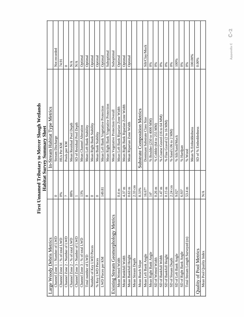
Firs
t Unn
amed
Tri
buta
ry to
Mer
cer
Slou
gh W
etla
nds
Hab
itat S
urve
y Su
mm
ary
Shee
t La
rge
Woo
dy D
ebris
Met
rics
In
-Stre
am H
abita
t Typ
e M
etric
s
C
hann
el Z
one
1 - N
umbe
r of L
WD
0
St
ream
Dis
char
ge
Not
reco
rded
Cha
nnel
Zon
e 1
- % o
f tot
al L
WD
0%
HU
s Per
KM
74
.91
C
hann
el Z
one
2 - N
umbe
r of L
WD
7
Po
ols p
er K
M
0
Cha
nnel
Zon
e 2
- % o
f tot
al L
WD
88
%
M
ean
Res
idua
l Poo
l Dep
th
N/A
Cha
nnel
Zon
e 3
- Num
ber o
f LW
D
1
SD o
f Res
idua
l Poo
l Dep
th
N/A
Cha
nnel
Zon
e 3
- % o
f tot
al L
WD
13
%
M
ean
Cha
nnel
Alte
ratio
n O
ptim
al
To
tal n
umbe
r of L
WD
8
M
ean
Left
Ban
k St
abili
ty
Opt
imal
Num
ber o
f Key
LW
D P
iece
s 0
M
ean
Rig
ht B
ank
Stab
ility
O
ptim
al
%
Key
LW
D P
iece
s 0
M
ean
Ban
k St
abili
ty
Opt
imal
LWD
Pie
ces p
er K
M
149.
81
M
ean
Left
Ban
k V
eget
ativ
e Pr
otec
tion
Opt
imal
M
ean
Rig
ht B
ank
Veg
etat
ive
Prot
ectio
n Su
bopt
imal
Exis
ting
Stre
am G
eom
orph
olog
y M
etric
s
M
ean
Veg
etat
ive
Prot
ectio
n O
vera
ll Su
bopt
imal
Mea
n W
ette
d W
idth
0.
4 m
Mea
n Le
ft B
ank
Rip
aria
n Zo
ne W
idth
O
ptim
al
M
ean
Ban
kful
l Wid
th
4.37
m
M
ean
Rig
ht B
ank
Rip
aria
n Zo
ne W
idth
O
ptim
al
M
ean
Ban
kful
l Hei
ght
0.63
m
M
ean
Rip
aria
n Zo
ne W
idth
O
ptim
al
M
ean
Stre
am D
epth
2.
33 c
m
Mea
n R
each
Slo
pe
8.33
%
Subs
trate
Com
posi
tion
Met
rics
Mea
n Le
ft B
ank
Ang
le
16.6
7°
D
omin
ant S
ubst
rate
Cla
ss S
ize
Silt/
Cla
y/M
uck
M
ean
Rig
ht B
ank
Ang
le
14°
%
Bou
lder
(250
to 4
000
MM
) 0%
SD o
f Wet
ted
Wid
th
0.26
m
%
Cob
ble
(64
to 2
55 M
M)
0%
SD
of B
ankf
ull W
idth
1.
47 m
% C
oars
e G
rave
l (16
to 6
4 M
M)
0%
SD
of B
ankf
ull H
eigh
t 0.
15 m
% F
ine
Gra
vel (
2 to
16
MM
) 0%
SD o
f Stre
am D
epth
2.
24 c
m
%
San
d (.0
6 to
2 M
M)
0%
SD
of L
eft B
ank
Ang
le
9.02
°
% S
ilt/S
and/
Muc
k
100%
SD o
f Rig
ht B
ank
Ang
le
6.93
°
% H
ardp
an
0%
To
tal S
tream
Len
gth
Surv
eyed
(m)
53.4
m
%
Woo
d 0%
M
ean
% E
mbe
dded
ness
10
0.00
%
Qua
lity
of P
ool M
etric
s
SD
of %
Em
bedd
edne
ss
0.00
%
M
ean
Pool
Qua
lity
Inde
x N
/A
Ap
pen
dix
C
C-2
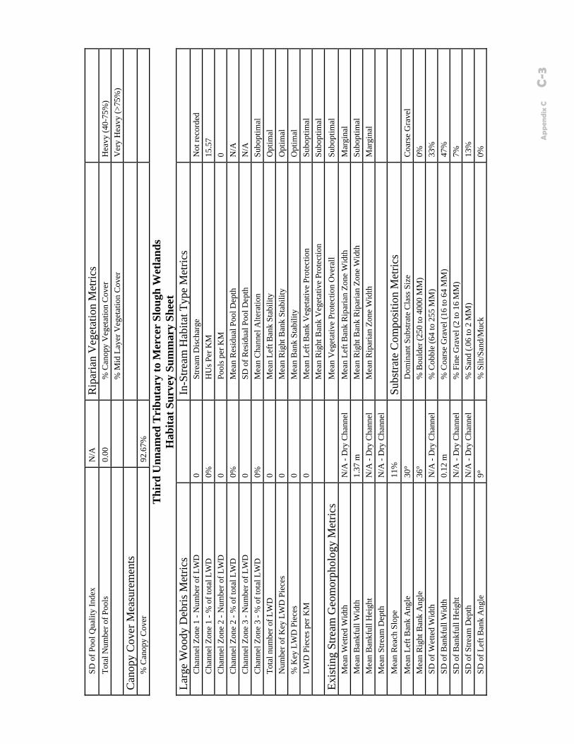
SD
of P
ool Q
ualit
y In
dex
N/A
R
ipar
ian
Veg
etat
ion
Met
rics
Tota
l Num
ber o
f Poo
ls
0.00
% C
anop
y V
eget
atio
n C
over
H
eavy
(40-
75%
)
%
Mid
Lay
er V
eget
atio
n C
over
V
ery
Hea
vy (>
75%
)
Can
opy
Cov
er M
easu
rem
ents
% C
anop
y C
over
92
.67%
Thi
rd U
nnam
ed T
ribu
tary
to M
erce
r Sl
ough
Wet
land
s H
abita
t Sur
vey
Sum
mar
y Sh
eet
Larg
e W
oody
Deb
ris M
etric
s
In-S
tream
Hab
itat T
ype
Met
rics
Cha
nnel
Zon
e 1
- Num
ber o
f LW
D
0
Stre
am D
isch
arge
N
ot re
cord
ed
C
hann
el Z
one
1 - %
of t
otal
LW
D
0%
H
Us P
er K
M
15.5
7
Cha
nnel
Zon
e 2
- Num
ber o
f LW
D
0
Pool
s per
KM
0
C
hann
el Z
one
2 - %
of t
otal
LW
D
0%
M
ean
Res
idua
l Poo
l Dep
th
N/A
Cha
nnel
Zon
e 3
- Num
ber o
f LW
D
0
SD o
f Res
idua
l Poo
l Dep
th
N/A
Cha
nnel
Zon
e 3
- % o
f tot
al L
WD
0%
Mea
n C
hann
el A
ltera
tion
Su
bopt
imal
To
tal n
umbe
r of L
WD
0
M
ean
Left
Ban
k St
abili
ty
Opt
imal
Num
ber o
f Key
LW
D P
iece
s 0
M
ean
Rig
ht B
ank
Stab
ility
O
ptim
al
%
Key
LW
D P
iece
s 0
M
ean
Ban
k St
abili
ty
Opt
imal
LWD
Pie
ces p
er K
M
0
Mea
n Le
ft B
ank
Veg
etat
ive
Prot
ectio
n Su
bopt
imal
M
ean
Rig
ht B
ank
Veg
etat
ive
Prot
ectio
n Su
bopt
imal
Exis
ting
Stre
am G
eom
orph
olog
y M
etric
s
M
ean
Veg
etat
ive
Prot
ectio
n O
vera
ll Su
bopt
imal
Mea
n W
ette
d W
idth
N
/A -
Dry
Cha
nnel
Mea
n Le
ft B
ank
Rip
aria
n Zo
ne W
idth
M
argi
nal
M
ean
Ban
kful
l Wid
th
1.37
m
M
ean
Rig
ht B
ank
Rip
aria
n Zo
ne W
idth
Su
bopt
imal
Mea
n B
ankf
ull H
eigh
t N
/A -
Dry
Cha
nnel
Mea
n R
ipar
ian
Zone
Wid
th
Mar
gina
l
Mea
n St
ream
Dep
th
N/A
- D
ry C
hann
el
Mea
n R
each
Slo
pe
11%
Su
bstra
te C
ompo
sitio
n M
etric
s
M
ean
Left
Ban
k A
ngle
30
°
Dom
inan
t Sub
stra
te C
lass
Siz
e C
oars
e G
rave
l
Mea
n R
ight
Ban
k A
ngle
36
°
% B
ould
er (2
50 to
400
0 M
M)
0%
SD
of W
ette
d W
idth
N
/A -
Dry
Cha
nnel
% C
obbl
e (6
4 to
255
MM
) 33
%
SD
of B
ankf
ull W
idth
0.
12 m
% C
oars
e G
rave
l (16
to 6
4 M
M)
47%
SD o
f Ban
kful
l Hei
ght
N/A
- D
ry C
hann
el
%
Fin
e G
rave
l (2
to 1
6 M
M)
7%
SD
of S
tream
Dep
th
N/A
- D
ry C
hann
el
%
San
d (.0
6 to
2 M
M)
13%
SD o
f Lef
t Ban
k A
ngle
9°
% S
ilt/S
and/
Muc
k
0%
Ap
pen
dix
C
C-3
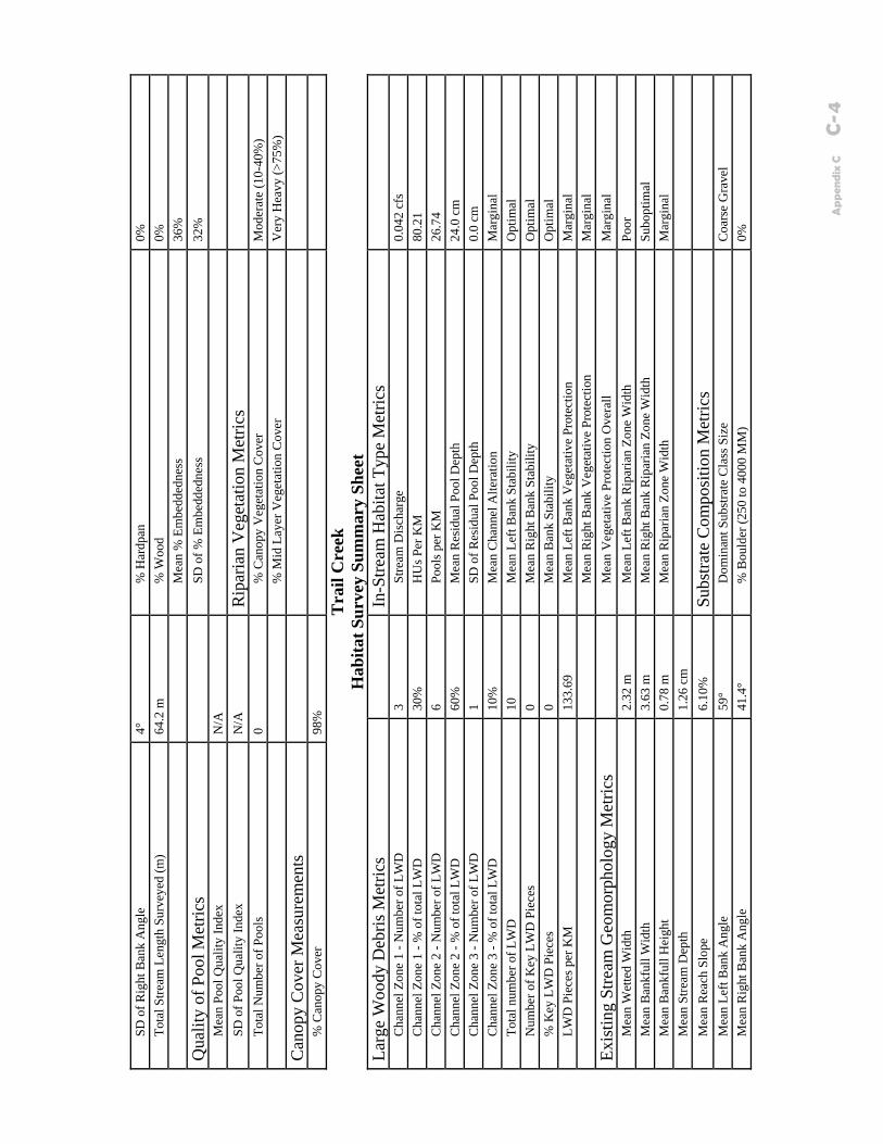
SD
of R
ight
Ban
k A
ngle
4°
% H
ardp
an
0%
To
tal S
tream
Len
gth
Surv
eyed
(m)
64.2
m
%
Woo
d 0%
M
ean
% E
mbe
dded
ness
36
%
Qua
lity
of P
ool M
etric
s
SD
of %
Em
bedd
edne
ss
32%
Mea
n Po
ol Q
ualit
y In
dex
N/A
SD
of P
ool Q
ualit
y In
dex
N/A
R
ipar
ian
Veg
etat
ion
Met
rics
Tota
l Num
ber o
f Poo
ls
0
% C
anop
y V
eget
atio
n C
over
M
oder
ate
(10-
40%
)
%
Mid
Lay
er V
eget
atio
n C
over
V
ery
Hea
vy (>
75%
)
Can
opy
Cov
er M
easu
rem
ents
% C
anop
y C
over
98
%
Tra
il C
reek
H
abita
t Sur
vey
Sum
mar
y Sh
eet
Larg
e W
oody
Deb
ris M
etric
s
In-S
tream
Hab
itat T
ype
Met
rics
Cha
nnel
Zon
e 1
- Num
ber o
f LW
D
3
Stre
am D
isch
arge
0.
042
cfs
C
hann
el Z
one
1 - %
of t
otal
LW
D
30%
HU
s Per
KM
80
.21
C
hann
el Z
one
2 - N
umbe
r of L
WD
6
Po
ols p
er K
M
26.7
4
Cha
nnel
Zon
e 2
- % o
f tot
al L
WD
60
%
M
ean
Res
idua
l Poo
l Dep
th
24.0
cm
Cha
nnel
Zon
e 3
- Num
ber o
f LW
D
1
SD o
f Res
idua
l Poo
l Dep
th
0.0
cm
C
hann
el Z
one
3 - %
of t
otal
LW
D
10%
Mea
n C
hann
el A
ltera
tion
Mar
gina
l
Tota
l num
ber o
f LW
D
10
M
ean
Left
Ban
k St
abili
ty
Opt
imal
Num
ber o
f Key
LW
D P
iece
s 0
M
ean
Rig
ht B
ank
Stab
ility
O
ptim
al
%
Key
LW
D P
iece
s 0
M
ean
Ban
k St
abili
ty
Opt
imal
LWD
Pie
ces p
er K
M
133.
69
M
ean
Left
Ban
k V
eget
ativ
e Pr
otec
tion
Mar
gina
l
M
ean
Rig
ht B
ank
Veg
etat
ive
Prot
ectio
n M
argi
nal
Exis
ting
Stre
am G
eom
orph
olog
y M
etric
s
M
ean
Veg
etat
ive
Prot
ectio
n O
vera
ll M
argi
nal
M
ean
Wet
ted
Wid
th
2.32
m
M
ean
Left
Ban
k R
ipar
ian
Zone
Wid
th
Poor
Mea
n B
ankf
ull W
idth
3.
63 m
Mea
n R
ight
Ban
k R
ipar
ian
Zone
Wid
th
Subo
ptim
al
M
ean
Ban
kful
l Hei
ght
0.78
m
M
ean
Rip
aria
n Zo
ne W
idth
M
argi
nal
M
ean
Stre
am D
epth
1.
26 c
m
Mea
n R
each
Slo
pe
6.10
%
Subs
trate
Com
posi
tion
Met
rics
Mea
n Le
ft B
ank
Ang
le
59°
D
omin
ant S
ubst
rate
Cla
ss S
ize
Coa
rse
Gra
vel
M
ean
Rig
ht B
ank
Ang
le
41.4
°
% B
ould
er (2
50 to
400
0 M
M)
0%
Ap
pen
dix
C
C-4
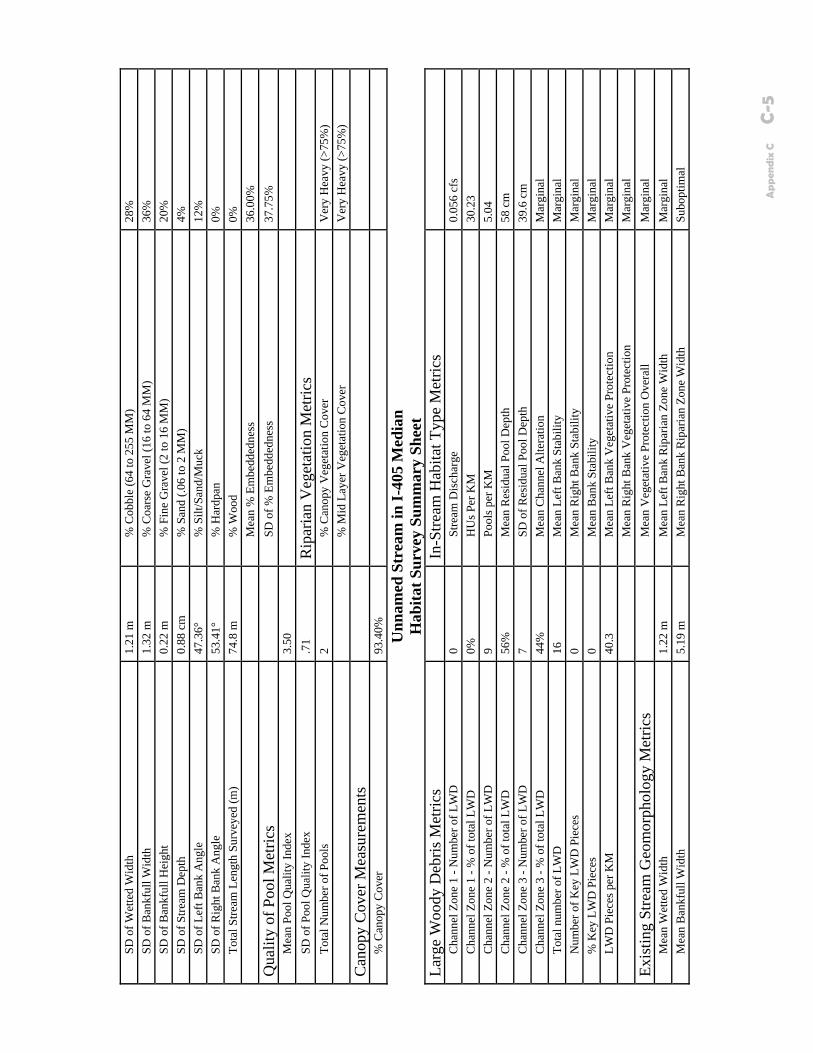
SD
of W
ette
d W
idth
1.
21 m
% C
obbl
e (6
4 to
255
MM
) 28
%
SD
of B
ankf
ull W
idth
1.
32 m
% C
oars
e G
rave
l (16
to 6
4 M
M)
36%
SD o
f Ban
kful
l Hei
ght
0.22
m
%
Fin
e G
rave
l (2
to 1
6 M
M)
20%
SD o
f Stre
am D
epth
0.
88 c
m
%
San
d (.0
6 to
2 M
M)
4%
SD
of L
eft B
ank
Ang
le
47.3
6°
%
Silt
/San
d/M
uck
12
%
SD
of R
ight
Ban
k A
ngle
53
.41°
% H
ardp
an
0%
To
tal S
tream
Len
gth
Surv
eyed
(m)
74.8
m
%
Woo
d 0%
M
ean
% E
mbe
dded
ness
36
.00%
Qua
lity
of P
ool M
etric
s
SD
of %
Em
bedd
edne
ss
37.7
5%
M
ean
Pool
Qua
lity
Inde
x 3.
50
SD o
f Poo
l Qua
lity
Inde
x .7
1 R
ipar
ian
Veg
etat
ion
Met
rics
Tota
l Num
ber o
f Poo
ls
2
% C
anop
y V
eget
atio
n C
over
V
ery
Hea
vy (>
75%
)
%
Mid
Lay
er V
eget
atio
n C
over
V
ery
Hea
vy (>
75%
)
Can
opy
Cov
er M
easu
rem
ents
% C
anop
y C
over
93
.40%
Unn
amed
Str
eam
in I-
405
Med
ian
Hab
itat S
urve
y Su
mm
ary
Shee
t La
rge
Woo
dy D
ebris
Met
rics
In
-Stre
am H
abita
t Typ
e M
etric
s
C
hann
el Z
one
1 - N
umbe
r of L
WD
0
St
ream
Dis
char
ge
0.05
6 cf
s
Cha
nnel
Zon
e 1
- % o
f tot
al L
WD
0%
HU
s Per
KM
30
.23
C
hann
el Z
one
2 - N
umbe
r of L
WD
9
Po
ols p
er K
M
5.04
Cha
nnel
Zon
e 2
- % o
f tot
al L
WD
56
%
M
ean
Res
idua
l Poo
l Dep
th
58 c
m
C
hann
el Z
one
3 - N
umbe
r of L
WD
7
SD
of R
esid
ual P
ool D
epth
39
.6 c
m
C
hann
el Z
one
3 - %
of t
otal
LW
D
44%
Mea
n C
hann
el A
ltera
tion
Mar
gina
l
Tota
l num
ber o
f LW
D
16
M
ean
Left
Ban
k St
abili
ty
Mar
gina
l
Num
ber o
f Key
LW
D P
iece
s 0
M
ean
Rig
ht B
ank
Stab
ility
M
argi
nal
%
Key
LW
D P
iece
s 0
M
ean
Ban
k St
abili
ty
Mar
gina
l
LWD
Pie
ces p
er K
M
40.3
Mea
n Le
ft B
ank
Veg
etat
ive
Prot
ectio
n M
argi
nal
Mea
n R
ight
Ban
k V
eget
ativ
e Pr
otec
tion
Mar
gina
l
Exis
ting
Stre
am G
eom
orph
olog
y M
etric
s
M
ean
Veg
etat
ive
Prot
ectio
n O
vera
ll M
argi
nal
M
ean
Wet
ted
Wid
th
1.22
m
M
ean
Left
Ban
k R
ipar
ian
Zone
Wid
th
Mar
gina
l
Mea
n B
ankf
ull W
idth
5.
19 m
Mea
n R
ight
Ban
k R
ipar
ian
Zone
Wid
th
Subo
ptim
al
Ap
pen
dix
C
C-5

M
ean
Ban
kful
l Hei
ght
0.62
m
M
ean
Rip
aria
n Zo
ne W
idth
Su
bopt
imal
Mea
n St
ream
Dep
th
8.65
cm
M
ean
Rea
ch S
lope
2.
79%
Su
bstra
te C
ompo
sitio
n M
etric
s
M
ean
Left
Ban
k A
ngle
35
.06°
Dom
inan
t Sub
stra
te C
lass
Siz
e Si
lt/C
lay/
Muc
k
Mea
n R
ight
Ban
k A
ngle
26
.88°
% B
ould
er (2
50 to
400
0 M
M)
0%
SD
of W
ette
d W
idth
0.
67 m
% C
obbl
e (6
4 to
255
MM
) 8%
SD o
f Ban
kful
l Wid
th
3.07
m
%
Coa
rse
Gra
vel (
16 to
64
MM
) 6%
SD o
f Ban
kful
l Hei
ght
0.24
m
%
Fin
e G
rave
l (2
to 1
6 M
M)
5%
SD
of S
tream
Dep
th
7.31
cm
% S
and
(.06
to 2
MM
) 18
%
SD
of L
eft B
ank
Ang
le
31.9
1°
%
Silt
/San
d/M
uck
63
%
SD
of R
ight
Ban
k A
ngle
17
.23°
% H
ardp
an
0%
To
tal S
tream
Len
gth
Surv
eyed
(m)
397
m
%
Woo
d 1%
M
ean
% E
mbe
dded
ness
84
.13%
Qua
lity
of P
ool M
etric
s
SD
of %
Em
bedd
edne
ss
30.7
6%
M
ean
Pool
Qua
lity
Inde
x 4.
00
SD o
f Poo
l Qua
lity
Inde
x 1.
41
Rip
aria
n V
eget
atio
n M
etric
s
To
tal N
umbe
r of P
ools
2
%
Can
opy
Veg
etat
ion
Cov
er
Spar
se (<
10%
)
%
Mid
Lay
er V
eget
atio
n C
over
H
eavy
(40-
70%
)
Can
opy
Cov
er M
easu
rem
ents
% C
anop
y C
over
91
.34%
Kel
sey
Cre
ek
Hab
itat S
urve
y Su
mm
ary
Shee
t La
rge
Woo
dy D
ebris
Met
rics
In
-Stre
am H
abita
t Typ
e M
etric
s
C
hann
el Z
one
1 - N
umbe
r of L
WD
1
St
ream
Dis
char
ge
18.3
21 c
fs
C
hann
el Z
one
1 - %
of t
otal
LW
D
11%
HU
s Per
KM
54
.82
C
hann
el Z
one
2 - N
umbe
r of L
WD
5
Po
ols p
er K
M
21.9
3
Cha
nnel
Zon
e 2
- % o
f tot
al L
WD
56
%
M
ean
Res
idua
l Poo
l Dep
th
64.5
cm
Cha
nnel
Zon
e 3
- Num
ber o
f LW
D
3
SD o
f Res
idua
l Poo
l Dep
th
21.9
2 cm
Cha
nnel
Zon
e 3
- % o
f tot
al L
WD
33
%
M
ean
Cha
nnel
Alte
ratio
n
Subo
ptim
al
Tota
l num
ber o
f LW
D
9
Mea
n Le
ft B
ank
Stab
ility
M
argi
nal
N
umbe
r of K
ey L
WD
Pie
ces
0
Mea
n R
ight
Ban
k St
abili
ty
Mar
gina
l
% K
ey L
WD
Pie
ces
0
Mea
n B
ank
Stab
ility
M
argi
nal
Ap
pen
dix
C
C-6
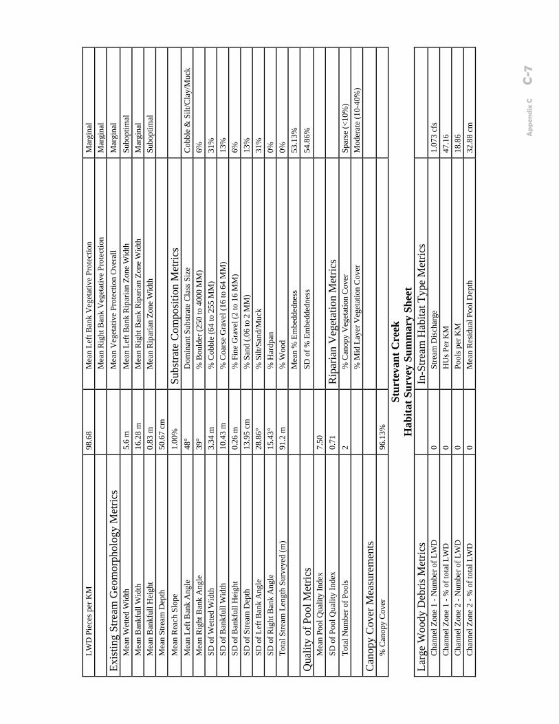
LW
D P
iece
s per
KM
98
.68
M
ean
Left
Ban
k V
eget
ativ
e Pr
otec
tion
Mar
gina
l
M
ean
Rig
ht B
ank
Veg
etat
ive
Prot
ectio
n M
argi
nal
Exis
ting
Stre
am G
eom
orph
olog
y M
etric
s
M
ean
Veg
etat
ive
Prot
ectio
n O
vera
ll M
argi
nal
M
ean
Wet
ted
Wid
th
5.6
m
M
ean
Left
Ban
k R
ipar
ian
Zone
Wid
th
Subo
ptim
al
M
ean
Ban
kful
l Wid
th
16.2
8 m
Mea
n R
ight
Ban
k R
ipar
ian
Zone
Wid
th
Mar
gina
l
Mea
n B
ankf
ull H
eigh
t 0.
83 m
Mea
n R
ipar
ian
Zone
Wid
th
Subo
ptim
al
M
ean
Stre
am D
epth
50
.67
cm
Mea
n R
each
Slo
pe
1.00
%
Subs
trate
Com
posi
tion
Met
rics
Mea
n Le
ft B
ank
Ang
le
48°
D
omin
ant S
ubst
rate
Cla
ss S
ize
Cob
ble
& S
ilt/C
lay/
Muc
k
Mea
n R
ight
Ban
k A
ngle
39
°
% B
ould
er (2
50 to
400
0 M
M)
6%
SD
of W
ette
d W
idth
3.
34 m
% C
obbl
e (6
4 to
255
MM
) 31
%
SD
of B
ankf
ull W
idth
10
.43
m
%
Coa
rse
Gra
vel (
16 to
64
MM
) 13
%
SD
of B
ankf
ull H
eigh
t 0.
26 m
% F
ine
Gra
vel (
2 to
16
MM
) 6%
SD o
f Stre
am D
epth
13
.95
cm
%
San
d (.0
6 to
2 M
M)
13%
SD o
f Lef
t Ban
k A
ngle
28
.86°
% S
ilt/S
and/
Muc
k
31%
SD o
f Rig
ht B
ank
Ang
le
15.4
3°
%
Har
dpan
0%
Tota
l Stre
am L
engt
h Su
rvey
ed (m
) 91
.2 m
% W
ood
0%
Mea
n %
Em
bedd
edne
ss
53.1
3%
Qua
lity
of P
ool M
etric
s
SD
of %
Em
bedd
edne
ss
54.8
6%
M
ean
Pool
Qua
lity
Inde
x 7.
50
SD o
f Poo
l Qua
lity
Inde
x 0.
71
Rip
aria
n V
eget
atio
n M
etric
s
To
tal N
umbe
r of P
ools
2
%
Can
opy
Veg
etat
ion
Cov
er
Spar
se (<
10%
)
%
Mid
Lay
er V
eget
atio
n C
over
M
oder
ate
(10-
40%
)
Can
opy
Cov
er M
easu
rem
ents
% C
anop
y C
over
96
.13%
Stur
teva
nt C
reek
H
abita
t Sur
vey
Sum
mar
y Sh
eet
Larg
e W
oody
Deb
ris M
etric
s
In-S
tream
Hab
itat T
ype
Met
rics
Cha
nnel
Zon
e 1
- Num
ber o
f LW
D
0
Stre
am D
isch
arge
1.
073
cfs
C
hann
el Z
one
1 - %
of t
otal
LW
D
0
HU
s Per
KM
47
.16
C
hann
el Z
one
2 - N
umbe
r of L
WD
0
Po
ols p
er K
M
18.8
6
Cha
nnel
Zon
e 2
- % o
f tot
al L
WD
0
M
ean
Res
idua
l Poo
l Dep
th
32.8
8 cm
Ap
pen
dix
C
C-7

C
hann
el Z
one
3 - N
umbe
r of L
WD
1
SD
of R
esid
ual P
ool D
epth
4.
45 c
m
C
hann
el Z
one
3 - %
of t
otal
LW
D
100%
Mea
n C
hann
el A
ltera
tion
Mar
gina
l
Tota
l num
ber o
f LW
D
1
Mea
n Le
ft B
ank
Stab
ility
M
argi
nal
N
umbe
r of K
ey L
WD
Pie
ces
0
Mea
n R
ight
Ban
k St
abili
ty
Mar
gina
l
% K
ey L
WD
Pie
ces
0
Mea
n B
ank
Stab
ility
M
argi
nal
LW
D P
iece
s per
KM
2.
36
M
ean
Left
Ban
k V
eget
ativ
e Pr
otec
tion
Poor
M
ean
Rig
ht B
ank
Veg
etat
ive
Prot
ectio
n Po
or
Exis
ting
Stre
am G
eom
orph
olog
y M
etric
s
M
ean
Veg
etat
ive
Prot
ectio
n O
vera
ll Po
or
M
ean
Wet
ted
Wid
th
2.20
m
M
ean
Left
Ban
k R
ipar
ian
Zone
Wid
th
Poor
Mea
n B
ankf
ull W
idth
7.
71 m
Mea
n R
ight
Ban
k R
ipar
ian
Zone
Wid
th
Poor
Mea
n B
ankf
ull H
eigh
t 0.
74 m
Mea
n R
ipar
ian
Zone
Wid
th
Poor
Mea
n St
ream
Dep
th
15.2
0 cm
M
ean
Rea
ch S
lope
1%
Su
bstra
te C
ompo
sitio
n M
etric
s
M
ean
Left
Ban
k A
ngle
75
°
Dom
inan
t Sub
stra
te C
lass
Siz
e
Fi
neG
rave
l
Mea
n R
ight
Ban
k A
ngle
81
°
% B
ould
er (2
50 to
400
0 M
M)
4%
SD
of W
ette
d W
idth
0.
54 m
% C
obbl
e (6
4 to
255
MM
) 8%
SD o
f Ban
kful
l Wid
th
1.61
m
%
Coa
rse
Gra
vel (
16 to
64
MM
) 20
%
SD
of B
ankf
ull H
eigh
t 0.
13 m
% F
ine
Gra
vel (
2 to
16
MM
) 46
%
SD
of S
tream
Dep
th
11.6
9 cm
% S
and
(.06
to 2
MM
) 14
%
SD
of L
eft B
ank
Ang
le
47°
%
Silt
/San
d/M
uck
4%
SD o
f Rig
ht B
ank
Ang
le
43°
%
Har
dpan
0%
Tota
l Stre
am L
engt
h Su
rvey
ed (m
) 42
4.1
m
%
Woo
d 4%
M
ean
% E
mbe
dded
ness
40
%
Qua
lity
of P
ool M
etric
s
SD
of %
Em
bedd
edne
ss
35%
Mea
n Po
ol Q
ualit
y In
dex
5.88
SD
of P
ool Q
ualit
y In
dex
1.55
R
ipar
ian
Veg
etat
ion
Met
rics
Tota
l Num
ber o
f Poo
ls
8
% C
anop
y V
eget
atio
n C
over
M
oder
ate
(10-
40%
)
%
Mid
Lay
er V
eget
atio
n C
over
Sp
arse
(<10
%)
Can
opy
Cov
er M
easu
rem
ents
% C
anop
y C
over
84
%
Ap
pen
dix
C
C-8

![3.3 Aquatic Resources - California State Water Resources ... · Section 3.3.5 [Aquatic Resources] Potential Impacts and Mitigation. 3.3.2.1 Aquatic Species Numerous aquatic species](https://img.pdfslide.us/doc/110x75/5fdf05efaeffa42ca171b579/33-aquatic-resources-california-state-water-resources-section-335-aquatic.jpg)