Embed Size (px)
Citation preview
Final Report
Kitchener Integrated Transportation Master Plan TRANSPORTATION’S ROLE IN A COMPLETE AND HEALTHY KITCHENER
June 2013


Table of Contents
JUNE 2013 I.
Executive Summary: Implementation Measures ........................................ 1
1. Travel Safety .............................................................................................................. 1
2. Active Transportation ............................................................................................... 1
3. Transportation Demand Management .................................................................... 3
4. Neighbourhood Traffic Management ...................................................................... 4
5. Parking Supply and Management ........................................................................... 4
5.2 Zoning Bylaw Parking Provisions ......................................................................... 5
6. Goods Movement ...................................................................................................... 5
7. Traffic Control ........................................................................................................... 6
8. Master Plan Implementation .................................................................................... 6
1. Planning Context .................................................................................. 1
1.1 Report Organization ............................................................................................ 1
1.2 Purpose & Scope of the Integrated Transportation Master Plan ................... 1
Purpose ........................................................................................................................... 1
Master Planning Scope ................................................................................................... 2
1.3 Transportation Planning Context ...................................................................... 3
1.4 Kitchener’s Transportation Goal & Objectives ................................................ 4
Goal 5
Objectives ....................................................................................................................... 5
1.5 Kitchener’s Transportation Vision 2031 ........................................................... 6
1.6 Kitchener’s Integrated Planning Process ......................................................... 7
A Plan for a Healthy Kitchener: Strategic Plan 2011-2014 ............................................. 7
A Plan for a Healthy Kitchener: 2007-2027 .................................................................... 8
Kitchener Strategic Plan for the Environment ................................................................. 8
Kitchener Growth Management Strategy – Planning for a Healthy Kitchener ............................................................................................................... 8
City of Kitchener Official Plan (2009) .............................................................................. 8
City of Kitchener Draft Official Plan: A Complete and Healthy Kitchener ....................... 9

I B I G R O U P F I N A L R E P O R T
TABLE OF CONTENTS (CONT’D)
1.7 Other Municipal TMPs in Waterloo Region ...................................................... 9
City of Waterloo Transportation Master Plan .................................................................. 9
City of Cambridge Transportation Plans ......................................................................... 9
Transportation Planning in the Townships ................................................................... 10
1.8 Provincial / Regional Planning Context .......................................................... 10
Provincial Policy Statement .......................................................................................... 10
Places to Grow ............................................................................................................. 11
Metrolinx Regional Transportation Plan ....................................................................... 12
Regional Transportation Master Plan: Moving Forward 2031 (RTMP) ........................ 12
Regional Official Plan (ROP) 2009 ............................................................................... 13
Regional Rapid Transit Plan ......................................................................................... 14
1.9 Status of the Master Plan under the Environmental Assessment Process .............................................................................................................. 14
1.10 Master Plan Implementation Mechanisms...................................................... 15
1.11 Project Direction ............................................................................................... 15
2. Public and Stakeholder Consultation ............................................... 17
2.1 Mandatory Consultation ................................................................................... 17
2.2 Advisory Committee Outreach Consultation ................................................. 17
2.3 Public Information Centre ................................................................................ 18
2.4 Advisory Committee Input ............................................................................... 19
Safe and Healthy Community Advisory Committee ..................................................... 19
Compass Kitchener Advisory Group ............................................................................ 19
Cycling Advisory Committee ......................................................................................... 20
Mayors Advisory Council for Kitchener Seniors ........................................................... 20
Downtown Action Advisory Committee ......................................................................... 20
Economic Development Advisory Committee .............................................................. 21
Kitchener Youth Action Council .................................................................................... 21
2.5 Summary of Main Consultation Messages ..................................................... 21
3. The Kitchener Context ....................................................................... 23
3.1 Kitchener Today ................................................................................................ 23
Key Challenges ............................................................................................................. 25
3.2 Kitchener in 2031 .............................................................................................. 26
4. Strategic Transportation Planning .................................................... 27
4.1 Alternative Strategies ....................................................................................... 27
Transit-Oriented Future with Strategic Road Improvements (Base) ............................ 27

I B I G R O U P F I N A L R E P O R T
TABLE OF CONTENTS (CONT’D)
Business As Usual (BAU) Future ................................................................................. 27
4.2 Existing / Future Kitchener Street Network Performance............................. 28
Level-of-Service (LOS) ................................................................................................. 28
Key Intersection and Corridor Review .......................................................................... 29
4.3 Implications of the Business As Usual (BAU) Future ................................... 33
4.4 Transportation Needs & Opportunities ........................................................... 35
Integrated Transportation System ................................................................................ 35
City Urban Structure Nodes and Corridors ................................................................... 36
Walking Facilities .......................................................................................................... 36
Cycling Facilities ........................................................................................................... 37
Accessibility Standards ................................................................................................. 38
Transit-Oriented Development...................................................................................... 40
Confirmation of Key Street Network Improvements ..................................................... 40
Implementation Measures – City Street Capacity Improvements ................................ 49
Implementation Measures – Regional Road Capacity Improvements ......................... 49
5. Transportation’s Role in a Complete & Healthy Kitchener ............. 52
5.1 Street Network Classification System ............................................................ 52
Existing Classification System ...................................................................................... 52
Recommended New Road Classification System ........................................................ 52
5.2 Travel Safety ...................................................................................................... 59
Implementation Measures ............................................................................................ 59
5.3 Active Transportation ....................................................................................... 60
Walking – Multi-use Pathways and Trails ..................................................................... 60
Walking – Sidewalks ..................................................................................................... 62
Implementation Measures - Walking ............................................................................ 63
Cycling .......................................................................................................................... 65
Implementation Measures - Cycling ............................................................................. 65
5.4 Transportation Demand Management ............................................................ 67
Implementation Measures ............................................................................................ 67
5.5 Neighbourhood Traffic Management (Traffic Calming) ................................ 68
Implementation Measures ............................................................................................ 69
5.6 Parking Supply and Management ................................................................... 71
Parking Enterprise ........................................................................................................ 71
Implementation Measures – Parking Enterprise........................................................... 71
Zoning Bylaw Parking Provisions ................................................................................. 72

I B I G R O U P F I N A L R E P O R T
TABLE OF CONTENTS (CONT’D)
Implementation Measures – Zoning Bylaw ................................................................... 73
5.7 Goods Movement .............................................................................................. 74
Implementation Measures ............................................................................................ 74
5.8 Traffic Control ................................................................................................... 75
Need for Uniform Traffic Control ................................................................................... 75
Current Roles and Responsibilities .............................................................................. 77
Safety versus Security and Capacity Considerations ................................................... 77
Road User Behaviour Considerations .......................................................................... 78
Implementation Measures ............................................................................................ 79
5.9 Growth Areas ..................................................................................................... 79
Urban Growth Centre .................................................................................................... 79
Primary Corridors .......................................................................................................... 79
Urban Nodes ................................................................................................................. 80
Rapid Transit Corridor Impacts ..................................................................................... 80
Major Transit Station Areas .......................................................................................... 81
Multi-Modal Transit Hub ................................................................................................ 82
6. Master Plan Implementation .............................................................. 83
6.1 Plan Review & Update ...................................................................................... 83
6.2 Implementation Measures & Phasing ............................................................. 83
Community Strategic Plan Values ................................................................................ 83
Summary of Measures .................................................................................................. 84
6.3 Performance Measures Framework ................................................................ 87
6.4 Funding Requirements ..................................................................................... 88
Capital Investment ........................................................................................................ 88
6.5 Plan Implementation ......................................................................................... 90
Implementation Through the Official Plan .................................................................... 90
Update Existing Official Plan Section 8 Policies ........................................................... 90
Implementation Through the Official Plan – New Policies ............................................ 93
Official Plan Schedule – Street Right-of-Way Widening ............................................... 94
Implementation Through the Development Approval Process ..................................... 94

IBI GROUP FINAL REPORT
KITCHENER INTEGRATED TRANSPORTATION MASTER PLAN Transportation‟s Role in a Complete & Healthy Kitchener
JUNE 2013 Page 1
Executive Summary: Implementation Measures
The following provides a summary of the main recommendations made in the
Transportation Master Plan (TMP) to implement strategic-level management and
operational improvements to the City of Kitchener transportation system over the
next 20 years. Reference should be made to the TMP text for more information
on each implementation measure.
1. Travel Safety
1.1 Continue to use collision data maintained by the Region of Waterloo from
all Regional roads and signalized intersections, and Regional Police Services
Motor Vehicle Collision Incident Reports on all public roadways. Data from
collisions on city streets should continue to be used in in-service road safety
reviews and road safety audits.
1.2 Use In-service safety reviews and road safety audits to identify factors
on city streets that are responsible for excessive collisions or could result in
future safety problems. In-service safety reviews can be conducted as part of
larger studies such as EAs and Transportation Impact Studies. Road Safety
Audits (RSA) can become part of the design process and used to avoid creating
or compounding road user safety problems associated with a road being
constructed or reconstructed.
1.3 Continue use of the Region’s Safety Countermeasures Program to enhance safety on Regional roads and at signalized intersections through research, pilot studies, collision analysis and application of countermeasures ranging from flashing beacons and roundabouts to pedestrian refuges and adjusted traffic signal timing. The same should be done for unsignalized intersections and City of Kitchener streets where appropriate. It is imperative that where such safety countermeasures are applied on city streets, they must be limited only to those that will impact the roadway environment positively.
2. Active Transportation
2.1 Walking
2.1.1 Implement the Multi-use Pathways and Trails Master Plan and
Pedestrian Charter as city-wide pedestrian strategies for the pedestrian
network and pedestrian environment to improve connectivity, safety and
integration of walking facilities with land use and transportation components.
2.1.2 Develop a new policy for sidewalk infilling in existing urbanized areas
and sidewalks in new development areas based on the principle of
“Complete Streets”. Complete Streets means that streets are designed to
accommodate all modes, including walking and cycling. Therefore, creating
Complete Streets mean no gaps are left in the sidewalk network except where
physical barriers prevent construction of a sidewalk.

I B I G R O U P F I N A L R E P O R T
KITCHENER INTEGRATED TRANSPORTATION MASTER PLAN
Transportation‟s Role in a Complete & Healthy Kitchener
JUNE 2013 Page 2
2.1.3 Continue the City’s Sidewalk Replacement Program on an annual
basis focusing on the creation of new sidewalks and walkways, as well as the
improvement of existing ones to expand and improve a pedestrian-friendly
environment
2.1.4 Implement more attractive streetscapes that include higher-order
pedestrian amenities such as street furniture, vegetation, lighting and
wayfinding. New streets and reconstruction projects should include
improvements to pedestrian infrastructure such as wider sidewalks where
warranted by pedestrian demand and where right-of-way width is available, safe
pedestrian crossing amenities that conform to established warrants and
accessibility elements including safer pathway road crossings and on-street
connections as detailed in the Multi-use Pathways and Trails Master Plan.
2.1.5 Establish pedestrians as a priority in developments and encourage the
highest level of pedestrian-oriented design and amenities through the planning
review process of new developments and redeveloped sites. Pedestrian-
supportive infrastructure, multi-use pathway and sidewalk design standards from
the City‟s Urban Design Manual and Multi-use Pathways and Trails Master Plan
should be implemented where possible, and new developments should require
pedestrian circulation plans to ensure connectivity with the surrounding
pedestrian network, barrier-free accessibility throughout, and convenient and
comfortable amenities that encourage high pedestrian activity.
2.1.6 Encourage active travel to/from schools and continue working with local
school, student and neighbourhood groups to identify barriers, safe routes and
other opportunities to walk to and from schools while highlighting the broader
community benefits of reduced greenhouse gases and active, healthy residents.
2.1.7 Ensure year-round maintenance programs for the pedestrian network
and review the City‟s sidewalk maintenance and snow-clearing practices to
ensure sidewalks and primary multi-use pathways are well-maintained and
cleared in a timely manner during the winter in order to improve safety for all
pedestrians.
2.2 Cycling
2.2.1 Implement the Kitchener Cycling Master Plan (KCMP) and Multi-use
Pathways and Trails Master Plan plus the Regional Cycling Master Plan
Update, including phased implementation of the bikeway network of signed
routes, local bicycle priority streets, shared-use lanes, paved shoulder bikeways,
bicycle lanes, and cycle tracks, as well as pathways and trails identified in the
Multi-use Pathways and Trails Master Plan. The City will phase implementation
of the cycling network over the next 20 years, and will continue to work with
Regional partners and the Kitchener Cycling Advisory Committee to identify
implementation issues or potential changes to the network to capture changes in
travel patterns, key destinations, new opportunities, and barriers or constraints.
2.2.2 Plan for bicycle-friendly communities within Kitchener by developing
and updating policies, guidelines and programs to include bicycle parking where
people live, work, shop and play. Similar to pedestrian strategies, developments
should make cyclists a priority through safe and direct connections to the cycling
network, bicycle-friendly site design of right-of-way and building elements, and
higher-order bicycle facilities that increase people‟s willingness to cycle as a
mode of transportation and recreation activity.

I B I G R O U P F I N A L R E P O R T
KITCHENER INTEGRATED TRANSPORTATION MASTER PLAN
Transportation‟s Role in a Complete & Healthy Kitchener
JUNE 2013 Page 3
2.2.3 Integrate cycling into municipal practices and consider the needs of
cyclists in transportation projects. New streets and reconstruction/resurfacing
projects will follow the preferred cycling infrastructure prescribed in the TMP. As
noted in the KCMP, the City will routinely consider, and actively encourage the
Region and neighbouring municipalities to consider, the needs of cyclists in all
phases of roadway and traffic management projects.
2.2.4 Further integrate cycling with other modes and provide for bicycle
facilities at major transit connectors, stations and stops to encourage multi-
modal cycling and transit as a viable mode of transportation for longer trips.
Cycling in Kitchener will be an integral part of the multimodal transportation
system. The KCMP recommends collaboration with the Region of Waterloo to
integrate cycling with Grand River Transit and future rapid transit including
connectivity of routes, stations and stops; bicycle parking at transit facilities and
on transit vehicles, and bikeways along key transit corridors.
2.2.5 Encourage active transportation for school trips by identifying and
addressing barriers to cycling to and from schools. The KCMP recommends the
City continue to partner with the Region of Waterloo Public Health and School
Boards on Active and Safe Routes to School events, curriculum, school travel
planning, and traffic and safety improvements in school catchment areas. In
addition, guidelines and programs to assist schools in providing more bicycle
parking facilities can promote cycling among students, faculty and staff.
2.2.6 Promote and support cycling with partnerships with the Region and
other stakeholders through programs that communicate the health and social
benefits of cycling, encourage cycling as a means of getting around the City and
as a recreational activity, and promote safety for all users – drivers, cyclists and
pedestrians alike.
2.2.7 Ensure maintenance and snow clearing of cycling routes through the
review and update of street maintenance and snow-clearing practices to better
accommodate year round cycling along all bikeways and trails.
3. Transportation Demand Management
3.1 Expand employer TDM programs in Kitchener through existing TDM tools
and services including membership in the TravelWise program to adopt carpool
ridematching, subsidized transit passes, guaranteed-ride home and outreach
programs to encourage City staff to choose sustainable modes of travel to and
from work. TDM efforts and outreach should be expanded beyond City staff and
beyond the downtown area to encourage major employers throughout the City to
adopt these efforts.
3.2 Have the city’s TDM Coordinator continue to work closely with the Region
and employers, especially in downtown Kitchener, to adopt TravelWise
programs, help implement other TDM strategies such as telework and carbon
tracking, and provide guidance on TDM-friendly site design of developments.
3.3 Support carsharing in the City through outreach and promotional events to
increase awareness, and provisions for preferred parking for carsharing vehicles
to promote these services, facilitate their growth and aid their long-term viability
in the City and the Region.
I B I G R O U P F I N A L R E P O R T
KITCHENER INTEGRATED TRANSPORTATION MASTER PLAN
Transportation‟s Role in a Complete & Healthy Kitchener
JUNE 2013 Page 4
3.4 Integrate TDM strategies into site planning and development approval
processes to provide for TDM-supportive measures in developments and
encourage sustainable transportation choices. The City should develop a TDM
checklist to help review and evaluate development applications, City of
Kitchener transportation-related projects and projects of the Region and
Province. This TDM checklist can include a requirement to prepare TDM plans
as part of transportation impact studies for new developments and major
transportation projects.
3.5 Work with Region and local partners to engage residents through
individualized marketing to promote and encourage sustainable modes of
transportation for all types of trips. As highlighted in the City‟s 2010 TDM plan,
individualized marketing is aimed at targeted populations or groups and tailors
the TDM strategies and programs based on the needs, opportunities and
willingness to use other modes of travel.
4. Neighbourhood Traffic Management
4.1 Review and update where required the City’s Traffic Calming Policy
focusing on three areas of possible improvements; 1) the traffic calming review
process extending from a request for traffic calming through to study and design
completion, 2) confirmation of warrants required to initiate traffic calming studies
and 3) the type of traffic calming measures that will be considered for use in the
City of Kitchener and where they can be used.
5. Parking Supply and Management
5.1 Parking Enterprise
The following measures are targeted to assist in the implementation by the
City‟s Parking Enterprise.
5.1.1 Assess and facilitate redevelopment opportunities of surface parking
lots and continue to develop city-owned parking structures and garages at key
locations to meet demand.
5.1.2 Implement parking recommendations from the City‟s Long-Term
Parking Strategy report, including continued annual increases in monthly parking
rates, setting monthly parking rates at about three times the cost of a monthly
transit pass, monitor long-stay parking demand and explore public-private
partnerships in the City Centre for future municipal parking facilities.:
5.1.3 Link TDM efforts with economic development to encourage downtown
employees to use alternative modes of transportation and encourage business
to implement TDM programs for their employees.
5.1.4 Coordinate Parking Enterprise and TDM initiatives together to create
maximum benefits and avoid competition between the two programs (i.e.
provision of parking supply versus encouraging use of alternative modes.
5.1.5 Regional parking strategies such as the development of a strategy for
park-and-ride facilities in conjunction with the planned LRT stations, support of

I B I G R O U P F I N A L R E P O R T
KITCHENER INTEGRATED TRANSPORTATION MASTER PLAN
Transportation‟s Role in a Complete & Healthy Kitchener
JUNE 2013 Page 5
TravelWise (the regional TDM program), and others as outlined in the Region of
Waterloo Parking Management Strategy.
5.2 Zoning Bylaw Parking Provisions
5.2.1 Review and update Zoning By-law to include revised parking
standards for both the downtown and the city as a whole that more accurately
reflect future modal split targets and encourage alternative modes of travel.
Consider the parking policy recommendations in the RTMP both region-wide
and rapid transit-related, and recommendations of the city‟s Urban Design
Manual for reduced parking requirements near rapid transit corridors and
stations.
6. Goods Movement
6.1 Plan for an effective and sustainable goods movement network in
Kitchener that provides direct, convenient and connected access to existing
and future employment lands, industrial and commercial developments, and
other major goods and service centres. A strategic goods movement network of
designated corridors will also reduce impacts to local residential communities,
traffic congestion, noise and air emissions, and improve safety and the efficiency
of goods and service delivery.
6.2 Improve connections and access to provincial highways and regional
arterials as part of a sustainable goods movement network. As noted in the
Region‟s TMP, trucking activity on Highway 401 and Highway 8 are significant
and improving access “is required to maximize accessibility to existing and
future industrial and employment areas and to reduce congestion levels on the
freeway system, which impedes overall trucking efficiency.”
6.3 Establish regular communication channels and continue to work with
stakeholders such as the goods movement industry and major
industries/businesses to direct higher volumes of goods movement to the
network, and identify local issues and opportunities to improve the efficiency of
the network.
6.4 Support more sustainable and innovative practices for local goods
movement to reduce impacts on neighbourhoods and local streets, including
alternative modes of transport and vehicle technologies for short-length and
local deliveries, restricting delivery times by heavy vehicles outside of peak
commuter time periods and exploring alternatives to direct pick-up and drop-off
goods movements.
6.5 Improve efficiency of the goods movement network through use of
intelligent transportation systems applied mainly to provincial highways and
Regional roads that benefits from such systems by providing real-time
information to industries and truck drivers to improve traffic flows and reduce
travel times, as well as improving goods movement data collection programs
used to analyse and improve travel patterns and overall safety.
6.6 Work with the Province and Region on higher-level policies and strategies
to improve goods movement within the realm of land use and transportation

I B I G R O U P F I N A L R E P O R T
KITCHENER INTEGRATED TRANSPORTATION MASTER PLAN
Transportation‟s Role in a Complete & Healthy Kitchener
JUNE 2013 Page 6
planning. This includes support for MTO‟s Freight-Supportive Guidelines and
the goods movement-related recommendations in the Region of Waterloo TMP.
7. Traffic Control
7.1 Maintain existing traffic control warrants as it is not recommended that
the City of Kitchener pursue the development of formal warrants beyond those
that are already in place.
8. Master Plan Implementation
8.1 Phase these Implementation Measures over the 0-5,-5-10 and 10-20 year
time horizons based on the phasing plan included as Exhibit 6.1 in the TMP in
response to the City‟s established Community Strategic Plan values, and in
consideration of implementation partners.
8.2 Apply a Performance Measures Framework described in Section 6.3 of
the TMP with indicators to gauge the effectiveness of the city‟s transportation
policies, programs and infrastructure improvements in achieving its
transportation goal, objectives and vision.
8.2 Budget required capital investments for roadway capacity enhancement
projects (widening, extensions), traffic calming projects, Active Transportation
infrastructure, TDM programs and parking infrastructure in the order of an
average $5.5M/year to 2017, $4.25M/year to 2022 and $3M/year to 2031.
8.3 Prioritize City roadway capacity enhancements for; 1) new north-south
arterial capacity in South Kitchener south of Huron Rd. (Strasburg Road
extension) in the planned growth area between Fischer-Hallman Rd. and Homer
Watson Blvd., 2) Huron Rd. widening, 3) Strasburg Rd. widening between Block
Line Rd. and Bleams Rd., 4) Block Line Rd. widening between Strasburg Rd.
and Homer Watson Rd. and 5) Wellington St. N/Shirley Ave. corridor widening
along with specific intersection improvements identified in the TMP and
implemented by the Ministry of Transportation.
8.4 Implement the TMP through updated Official Plan policies for an integrated
transportation system) with active transportation, transit-oriented development,
City streets, goods movement, neighbourhood traffic management (traffic
calming), Transportation Demand Management (TDM) and parking.

IBI GROUP FINAL REPORT
KITCHENER INTEGRATED TRANSPORTATION MASTER PLAN Transportation‟s Role in a Complete & Healthy Kitchener
JUNE 2013 Page 1
1. Planning Context
1.1 Report Organization
This report is organized into six (6) sections as follows:
Section 1 outlines the study purpose, goals and objectives, planning integration
and planning context;
Section 2 summarizes the community input provided to the study from public
consultation events;
Section 3 describes the planning background to this Kitchener Integrated
Transportation Master Plan (TMP), including the status of the existing
transportation system, and how the City is expected to grow to 2031;
Section 4 presents the strategic transportation planning alternatives to 2031,
the resulting transportation needs and opportunities;
Section 5 describes the role of transportation in a complete and healthy
Kitchener, including:
Streets;
Active Transportation;
Transportation Demand Management;
Neighbourhood Traffic Management and Calming;
Parking Supply and Management;
Goods Movement; and,
Growth Areas.
Section 6 recommends how to implement the recommendations of the TMP.
1.2 Purpose & Scope of the Integrated Transportation Master Plan
Purpose
The basic directions for transportation planning in the City of Kitchener were
initiated with Council's adoption of the city‟s Strategic Plan in 2007, and
Regional Council‟s adoption of the Regional Transportation Master Plan (Moving
Forward 2031) in 2011. The next stage is to agree on an overall plan to achieve
these transportation directions over the next 20 years in Kitchener. The need for
this plan was identified in the Kitchener Growth Management Strategy (KGMS
2009) under Goal 3 to Ensure Greater Transportation Choice, and Action 2 that
states:
I B I G R O U P F I N A L R E P O R T
KITCHENER INTEGRATED TRANSPORTATION MASTER PLAN
Transportation‟s Role in a Complete & Healthy Kitchener
JUNE 2013 Page 2
“Following the completion of the Regional Transportation Master Plan, the City
should identify the specific implications for Kitchener in a City Transportation
Master Plan should include TDM, cycling and walkability. Link the plan to the
KGMS and new Official Plan.”
Preparing Kitchener‟s TMP started from this strategic recommendation and
extends to the City‟s new Draft Official Plan.
The City of Kitchener has also adopted the following transportation-related
master plans to guide decision-making. The purpose of this TMP is to
“integrate” these plans with related transportation policies dealing with parking,
traffic calming, cycling, multi-use pathways and trails, transportation demand
management, strategic street improvements and urban design to create one
single city transportation plan.
Southwest Urban Area Community Master Plan / Rosenberg Secondary
Plan – Adopted August 2011, under appeal;
Transportation Demand Management Plan – Adopted in Principle
February 2011;
Kitchener Cycling Master Plan – Approved August 2010;
Multi-use Pathways and Trails Master Plan – Approved March 2012;
Kitchener Pedestrian Charter, April 2005
Parks Strategic Plan – Adopted October 2010; and
Parking Strategic Plan – Approved January 2011.
The TMP defines and prioritizes an integrated transportation system that is
supportive of all modes of travel under the jurisdiction of the City of Kitchener,
partnered with the Region of Waterloo. This includes walking, cycling and public
transit. The TMP also directs how to continue maintaining and improving the
City‟s street network to move people and goods, but with reduced dependence
on single occupant vehicles. This will be done in conjunction with Region of
Waterloo initiatives that support this balance of transportation modes in the City.
Master Planning Scope
According to the Municipal Class Environmental Assessment (EA) process,
master plans are:
“ long range plans which integrate infrastructure requirements for existing and
future land use with environmental assessment planning principles “.
To do this, the scope of the TMP is:
strategic system-wide planning, and not focused on specific projects that
will undergo further analysis through the Municipal Class EA process;
providing the need and justification for specific transportation
infrastructure projects by satisfying the first two phases of the Municipal

I B I G R O U P F I N A L R E P O R T
KITCHENER INTEGRATED TRANSPORTATION MASTER PLAN
Transportation‟s Role in a Complete & Healthy Kitchener
JUNE 2013 Page 3
Class EA process by addressing 1) Problems and Opportunities, and 2)
Alternative Planning Solutions;
future - oriented over a 20 year planning timeframe with the Kitchener
Official Plan to 2031;
multi-modal to address all modes of transportation under the jurisdiction
and responsibility of the City. In the case of Kitchener this includes
sidewalks, trails, bikeways and City roads;
refers to transportation planning experienced in other cities of similar
size and context, but ultimately is a plan custom-made for Kitchener;
integrates transportation and city planning by recommending how to
comply with Provincial, Regional and City growth management
strategies;
provides a set of actions on how the city can meet its transportation
needs and vision over the next 20 years. It is not based on any one
specific transportation project;
achievable within the context of the municipality it plans for socially,
practically, financially and politically;
consultative by providing opportunities for agencies, stakeholder groups
and the general public to contribute to the plan development; and
flexible to change over its 20 year planning timeframe through regular
reviews and updates to respond to changing conditions and needs.
1.3 Transportation Planning Context
The City of Kitchener is the largest municipality in the Region of Waterloo, a
dynamic metropolitan economy and community supporting high levels of
research and development. By 2031, Kitchener is expected to have
approximately 315,000 residents, an increase of about 90,000 over the
population in 2011.
The economy is also rapidly expanding, due largely to the innovative firms
emerging in clusters, and dynamic redevelopment and intensification especially
in Downtown Kitchener. It is a highly competitive, urban centre that supports a
high standard of living with innovation and capital investment.1
Changes in the city‟s demographics, as well as living, traveling and spending
habits will result in new urban travel demands. The aging population will
contribute to these transportation changes. These changes represent the
geographic and social context for the Kitchener TMP.
This planning context is described in a number of recent strategic and
community planning sources with examples provided as follows:
1 City of Kitchener 2007-2010 Economic Development Strategy

I B I G R O U P F I N A L R E P O R T
KITCHENER INTEGRATED TRANSPORTATION MASTER PLAN
Transportation‟s Role in a Complete & Healthy Kitchener
JUNE 2013 Page 4
“Transportation Demand Management – Aspiring to reduce traffic congestion,
commuting times, greenhouse gas production and smog, municipalities are
beginning to assess new ways of offering transportation services. For Kitchener
a potential new rapid transit system would redefine our urban structure...”
Source: 2007-2010 Kitchener Economic Development Strategy
“Over the coming years, Kitchener has an opportunity to define itself as a
cosmopolitan mid-sized city that combines the best of a small town quality of life
with the amenities of an urban centre.”
Source: Compass Kitchener, 2005 community surveys
“Kitchener is always a great place to be and a community that achieves an
optimal balance of economic prosperity, environmental sustainability and social
vitality, grounded securely in the values and culture of this community.”
Source: A Plan for a Healthy Kitchener 2007 to 2027: Community
Strategic Plan
“An aspect of big city transit systems that was consistently noted as beneficial
was less catering to and reliance on cars as the primary mode of transportation.
Increasing and improving bicycle lanes, paths, and trails were supported by
several respondents, as was increasing pedestrian paths and sidewalks.”
Source: Development Analysis Consultation Community Survey input,
Environics, 2005
“Many respondents mentioned the benefits of increased walkability of small
towns – meaning the ability to walk to most amenities required on a daily basis –
as something to continue promoting in Kitchener. Walkable neighbourhoods are
critical to a sense of community.”
Source: Development Analysis Consultation Community Survey input,
Environics, 2005
Citizens are realizing that there are significant environmental, health and
economic benefits to developing a diverse transportation network. As Kitchener
grows and concerns increase regarding the effect of air quality, climate change,
traffic congestion and shortages of fuel, residents are increasingly turning to
other transportation options, such as walking, cycling or taking public transit.
They are also demanding that more funding and resources be allocated toward
making these options more appealing and available to everyone in our
community
Source: A Plan for a Healthy Kitchener: Strategic Plan for 2011-2014
1.4 Kitchener‟s Transportation Goal & Objectives
One of the important steps in developing this TMP was to establish the
transportation planning goals, objectives and long-term vision for Kitchener‟s
transportation system over the next 20 years. Four sources of information were
used:
The project Terms of Reference;

I B I G R O U P F I N A L R E P O R T
KITCHENER INTEGRATED TRANSPORTATION MASTER PLAN
Transportation‟s Role in a Complete & Healthy Kitchener
JUNE 2013 Page 5
The City of Kitchener 2009 Citizens Survey conducted by Environics,
including the subsequent Who Are You Kitchener?;2
Kitchener: A View Towards the Future prepared by Environics for the
City and Compass Kitchener in 2005. Values-based information
generally does not change over long periods of time and is a
representative sample of Kitchener residents as confirmed by the
census profile; and
Meetings held with City of Kitchener Advisory Groups during November
2010.
Goal
The main goal of this TMP is to:
“plan a transportation system that reduces dependence on the private
automobile in Kitchener by 2031.”
To achieve this goal, viable alternatives to continued private auto use must be
provided in Kitchener over the next 20 years, in response to local community
context and needs. The alternative travel modes must provide levels of service
(i.e. travel cost, time, comfort) that compete effectively with auto use.”
This goal still recognizes that the automobile will remain the dominant mode of
transportation in the City and Region by the year 2031, but with reduced growth
in automobile use and increased use of alternative modes of transportation in
Kitchener.
Objectives
To meet this goal, this TMP was developed to address six (6) planning
objectives:
1. Develop guiding transportation policies for subjects ranging from traffic
control (traffic signals, roundabouts) through to parking requirements;
2. Provide planning direction to the year 2031 with short term, medium
term, and long term goals;
3. Provide transportation planning direction for enhanced alternative
modes of transportation (walking, cycling, and transit);
4. Develop an integrated transportation system that supports Regional bus
and planned rapid transit;
5. Describe how to develop a city that is less reliant on cars; and
6. Support City of Kitchener and Region of Waterloo growth management
strategies in a sustainable manner.
2 Who Are You Kitchener? Is a follow up engagement process that the City undertakes following every Environics survey to solicit additional
details and information based on the feedback we receive through Environics. The 6 pillars of information include: Quality of Life, Leadership and Community Engagement, Diversity, Development, Dynamic Downtown, and the Environment. Only Environment, Development and Quality of Life have been referenced for the TMP vision and goals because the others do not have much specific reference to transportation.

I B I G R O U P F I N A L R E P O R T
KITCHENER INTEGRATED TRANSPORTATION MASTER PLAN
Transportation‟s Role in a Complete & Healthy Kitchener
JUNE 2013 Page 6
1.5 Kitchener‟s Transportation Vision 2031
The timeframe of the TMP is 20 years to 2031, the same as the new Draft
Official Plan (OP). By 2031 the new Draft OP envisions a city of approximately
315,000 people, an increase of about 90,000 residents since 2011. Growth will
be based on a Plan for Healthy Kitchener that is more walkable, more transit
supportive and ultimately more “urban” while still striving to keep a high quality
of life.
By 2031, the City of Kitchener will have an integrated municipal transportation
system with the following features:
A balanced and efficient transportation system that moves people with a
range of modal options including walking, cycling, the Region‟s Grand
River Transit and automobiles;
This system is strategically located within and connected to the Region
of Waterloo and southern Ontario transportation systems to move
people and goods locally, regionally, provincially, nationally and
internationally;
Transportation contributes to the quality of life in Kitchener as a
cosmopolitan mid-sized city;
With a range of modal options, travel in Kitchener is less reliant on
gasoline powered autos and contributes more to climate change
mitigation and adaptation;
Infrastructure and services are provided for all modes of travel within
and through the City to manage congestion and other traffic problems,
and to promote public health and safety;
The Regional public transit system has enough service options, and
operates in transit-supportive land use patterns and Transit-Oriented
Development forms so that it competes effectively with private
automobile use in the City for those who want or need to use transit;
The City‟s integrated Active Transportation network links
walkable/bikeable communities that reduce automobile reliance, and
integrates community trails, bikeways and Scenic-Heritage Roads with
neighbourhood development;
Transportation infrastructure and services in Kitchener provides physical
mobility for everyone throughout the City, including those with mobility
limitations;
The intensification policies of the City and Region are supported by
transportation services as part of more intensified City and Region
growth management plans;
In Kitchener, a well-informed public understands transportation policies,
plans and management through effective communications from the City

I B I G R O U P F I N A L R E P O R T
KITCHENER INTEGRATED TRANSPORTATION MASTER PLAN
Transportation‟s Role in a Complete & Healthy Kitchener
JUNE 2013 Page 7
and Region, and actively participates in a transparent transportation
planning process;
The City supports the economic and social growth of Kitchener in part
with a well-funded transportation system that moves people and goods
for a wide range of businesses and industries; and
In Kitchener, local, regional and provincial transportation systems
involving walking, cycling, rapid transit, highways, commuter rail and
freight rail extend out from a strong, vibrant downtown.
1.6 Kitchener‟s Integrated Planning Process
Kitchener‟s strategic direction for growth and development starts with the
integration of a number of its strategic plans and related policies. Those that
reference transportation in Kitchener are noted as follows:
A Plan for a Healthy Kitchener: Strategic Plan 2011-2014
The Strategic Plan combines and addresses the following six (6) main
community priorities:
1. Quality of Life
2. Leadership & Community Engagement
3. Environment
4. Diversity
5. Development
6. Dynamic Downtown
According to the Strategic Plan, the community
context recognizes the significant environmental,
health and economic benefits to developing a
diverse transportation network. It is expected that
as Kitchener grows and concerns increase
regarding the effects of air quality, climate change,
traffic congestion and shortages of fuel, residents
will increasingly turn to other transportation options
such as walking, cycling or taking public transit. The
Plan then expects that in response to these
concerns, residents will demand more funding and
resources for alternative forms of transportation.
As a result, the City‟s Environment priority includes strategic direction to move
forward in implementing the cycling master plan and Transportation Demand
Management Plan. Other strategic directions include ensuring new
neighbourhoods are walkable communities, and that the City does more to
support alternative transportation options that connect neighbourhoods and
promote public transit.
The Strategic Plan is implemented through City plans and policies, including this
TMP which support the community priorities for transportation wherever
applicable.
Source: A Plan For a Healthy Kitchener: Strategic Plan 2011-2014

I B I G R O U P F I N A L R E P O R T
KITCHENER INTEGRATED TRANSPORTATION MASTER PLAN
Transportation‟s Role in a Complete & Healthy Kitchener
JUNE 2013 Page 8
A Plan for a Healthy Kitchener: 2007-2027
This document forms a basis for the City‟s Strategic Plan 2011-2014, and
provides a single strategic approach to delivering results that are essential to the
health and vitality of the city now and into the future. It is based on the three
overlapping healthy community characteristics of social, environmental and
economic well-being shown here.
Transportation-related priorities of the Healthy Community plan include:
physical accessibility improvements in City facilities;
a balanced approach to replacing and/or expanding infrastructure
including roads to support current and anticipated growth;
develop a Transportation Demand Management strategy to support
efficient, environmentally friendly transportation policies and programs
for the future.
Kitchener Strategic Plan for the Environment
This living document guides the development of the City‟s current and future
environmental initiatives, and identifies objectives and priorities for action in key
areas of focus. It does not specifically address transportation as an element of
the local environment, except in the context of air quality. It provides a high
level strategic foundation for all transportation recommendations and contributes
to improving environmental conditions.
Kitchener Growth Management Strategy – Planning for a Healthy Kitchener
This is one of a number of strategic documents that support the City‟s Strategic
Plan by providing a long-term framework on where and how future residential
and employment growth will be accommodated. It reflects Ontario‟s Places to
Grow Growth Plan with a community vision that includes convenient access to
public transportation and options for safe, non-motorized travel. One of its
specific goals is to ensure greater transportation choice by implementing a
Transportation Demand Management plan, transportation master plan and
cycling route installation plan.
“Kitchener tomorrow will be more walkable, more transit-supportive and
ultimately more „urban‟ while still striving to keep a high quality of life.”
Kitchener Growth Management Strategy, January 2009
City of Kitchener Official Plan (2009)
Policies and schedules are included in the City‟s current Official Plan (OP)
dealing with transportation, including cycling and pedestrian movement, public
transit, the road system, road widening and parking. Each has been reviewed in
light of the new strategic directions, policies and plans to ensure that the TMP
can be effectively implemented through the OP as updated.

I B I G R O U P F I N A L R E P O R T
KITCHENER INTEGRATED TRANSPORTATION MASTER PLAN
Transportation‟s Role in a Complete & Healthy Kitchener
JUNE 2013 Page 9
City of Kitchener Draft Official Plan: A Complete and Healthy Kitchener
The City's current Official Plan (OP) is being updated and brought into
conformity with provincial and regional legislation that has been introduced or
revised in recent years. Provincial legislation includes the Provincial Policy
Statement and the Places to Grow Growth Plan for the Greater Golden
Horseshoe. Regional policies consist of the new Regional Official Plan (ROP
currently under appeal before the OMB) and Regional Transportation Master
Plan.
The City‟s new Draft Official Plan (OP) (2nd
Draft, May 27, 2013) was prepared
in association with a number of related studies, plans and input, including this
TMP to bring it into conformity with Places to Grow and the Regional Official
Plan. The TMP, Cycling Master Plan, Multi-use Pathways and Trails Master Plan
and Transportation Demand Management Plan are all contributing parts of the
new Official Plan. None of these planning documents are statutory in nature,
and so are implemented at the direction of City Council. Implementation is
required only when the appropriate directions and recommendations of the TMP
are included as part of the OP.
1.7 Other Municipal TMPs in Waterloo Region
City of Waterloo Transportation Master Plan
The City of Waterloo approved in principle their Transportation Master Plan
(TMP) on April 18, 2011. The Plan provides the context and justification to
implement specific minor (Schedule B) transportation EA projects such as
intersection improvements, and major (Schedule C) transportation infrastructure
EA projects such as road widening and extensions proposed by the City of
Waterloo.
The Plan will be used to guide development of those components of the City‟s
transportation system that the City is responsible for, namely City roads,
bikeways, trails and sidewalks. It also addressed other transportation-related
City responsibilities involving transit-supportive land use planning, transportation
demand management, traffic calming, parking and street/sidewalk maintenance.
The Plan combines all of these transportation elements into a new and
innovative “Complete Street” approach where all streets in the City of Waterloo
are to be planned, designed, operated and maintained to enable safe access for
all users.
The Kitchener TMP makes reference to the Waterloo plan for inter-city planning
of City road, bikeway and community trails.
City of Cambridge Transportation Plans
The City of Cambridge prepared a comprehensive 20 year Cambridge Area
Transportation Study (CATS) in 1994, and this was augmented in 2002 with the
Detailed Transportation Network Review. Both were referenced in developing
the Kitchener TMP regarding transportation system extensions south from
I B I G R O U P F I N A L R E P O R T
KITCHENER INTEGRATED TRANSPORTATION MASTER PLAN
Transportation‟s Role in a Complete & Healthy Kitchener
JUNE 2013 Page 10
Kitchener. Cambridge has also developed trail and cycling plans that have been
integrated into Kitchener‟s Cycling Master Plan and Community Trails Master
Plan.
Transportation Planning in the Townships
The City of Kitchener is bordered by the Townships of Wilmot to the west, North
Dumfries to the south and Woolwich to the east. None of these rural
municipalities currently have a comprehensive transportation master plan, but
their Official Plans do include transportation-related policies and schedules of
their roadway classifications. Their strategic plans also identify transportation-
related priorities involving, for example, local traffic congestion and the future of
transit service.
The Kitchener TMP has considered these and other Township transportation
strategies and policies as they may relate to the City‟s transportation system
over the next 20 years.
1.8 Provincial / Regional Planning Context
Provincial Policy Statement
The Provincial Policy Statement (PPS) was issued by the province in 2005. The
PPS sets out the policy direction to guide land use planning and development in
Ontario that support three key areas: building strong communities, wise use and
management of resources, and protecting public health and safety.
The PPS calls for safe, energy efficient transportation systems that facilitate
movement of people and goods and support projected needs. It highlights the
importance of connectivity of transportation systems, integration of
transportation and land use planning to support sustainable transportation
choices, and efficient use of existing infrastructure.
The PPS requires that in planning matters, including development of a
Transportation Master Plan, decisions “shall be consistent with” policy
statements issued under the Act. In the case of the Kitchener TMP, the
following Provincial Policies should be supported:
Policy 1.1: Managing and Directing Land Use to Achieve efficient
Development and Land Use Patterns – The TMP should support the
growth directions and land use patterns developed for the City‟s official
Plan. This includes ensuring that necessary transportation infrastructure
is and will be available to meet current and projected needs;
Policy 1.1.4: Rural Areas in Municipalities – The TMP should avoid the
planning of unjustified and/or uneconomical transportation infrastructure
expansion in rural areas;
Policy 1.6.5: Transportation Systems – Transportation systems should
be planned to “facilitate the movement of people and goods, and which
are appropriate to address projected needs”. The strategic planning
direction set for the TMP will be based in part by the Growth
Management Plan for the efficient use of the City‟s existing and planned
transportation infrastructure. The TMP should also consider the

I B I G R O U P F I N A L R E P O R T
KITCHENER INTEGRATED TRANSPORTATION MASTER PLAN
Transportation‟s Role in a Complete & Healthy Kitchener
JUNE 2013 Page 11
connectivity of its transportation infrastructure with adjacent
municipalities and the integration of transportation modes where
appropriate and necessary. Strategies and plans should also be
provided in the TMP to “ minimize the length and number of vehicle
trips” and to “support the development of viable choices” for public
transit and active transportation in the City; and,
Policy 1.6.6: Transportation and Infrastructure Corridors –
Recommendations should be made in the TMP to identify and protect
required transportation corridor improvements and additions in the short,
medium and long term.
Places to Grow
The Government of Ontario released in 2006 the Places to Grow: Growth Plan
for the Greater Golden Horseshoe. It includes the City of Kitchener and the
Region of Waterloo as part of the GGH. The plan provides the framework to
guide effective planning and better growth management in the area as
population increases to 3.7 million in 2031. Places to Grow guides decisions on
transportation, infrastructure planning, land-use planning, urban form, housing,
natural heritage and resource protection in order to promote a high quality of life
, economic development and strong communities.
Places to Grow provides for intensification areas and targets within the built-up
area to accommodate future population and employment growth, and build more
compact, transit-supportive communities. In addition, the plan identifies 25
urban growth centres as focal areas where more intensified residential and
employment growth would take place, and would support major transit
infrastructure investments. Downtown Kitchener is one of the designated urban
growth centre in Places to Grow. It is expected that this area will achieve a
minimum gross density target of 200 residents and jobs per hectare by 2031.
The new emphasis on an intensified urban form and hard urban edges will
induce travel pattern changes in the City, especially for home-work trips. The
allocation of population and employment growth in the City and Region is now
influenced by Places to Grow and has been reflected in the travel demand
forecasting model used in the TMP.
More specifically, general transportation infrastructure policies in Places To
Grow that are incorporated into the Kitchener TMP to support growth include:
3.2.2.1 The transportation system within the GGH will be planned and
managed to -
a) provide connectivity among transportation modes for moving people and
for moving goods
b) offer a balance of transportation choices that reduces reliance upon any
single mode and promotes transit, cycling and walking
c) be sustainable, by encouraging the most financially and environmentally
appropriate mode for trip-making
d) offer multi-modal access to jobs, housing, schools, cultural and
recreational opportunities, and goods and services

I B I G R O U P F I N A L R E P O R T
KITCHENER INTEGRATED TRANSPORTATION MASTER PLAN
Transportation‟s Role in a Complete & Healthy Kitchener
JUNE 2013 Page 12
e) provide for the safety of system users.
3.2.2.3 The transportation system within the GGH will be planned and managed
to -
a) provide connectivity among transportation modes for moving people and
for moving goods
b) offer a balance of transportation choices that reduces reliance upon any
single mode and promotes transit, cycling and walking
c) be sustainable, by encouraging the most financially and environmentally
appropriate mode for trip-making
d) offer multi-modal access to jobs, housing, schools, cultural and
recreational opportunities and goods and services
3.2.2.5 Municipalities will develop and implement transportation demand
management policies in official plans or other planning documents, to reduce trip
distance and time, and increase the modal share of alternatives to the
automobile.
Metrolinx Regional Transportation Plan
Metrolinx, the regional transportation authority for the Greater Toronto and
Hamilton Area (GTHA), approved its regional transportation plan, The Big Move,
in November 2008. The 25-year plan includes a comprehensive regional transit
network, as well as potential rail extensions to regions outside the GTHA.
Specifically for the Region of Waterloo, the plan identifies inter-regional rail
connections to Kitchener-Waterloo via the Georgetown rail corridor and to
Cambridge via the Milton rail corridor. The GO Rail service from Kitchener to
Union Station commenced in December 2011.
Regional Transportation Master Plan: Moving Forward 2031 (RTMP)
The RTMP, approved in 2011, provides the Regional policy foundation for many
elements of the Kitchener Plan, including:
Strategic Direction for the regional transportation system;
Transition to a transit oriented network; and
Regional road network plans and priorities.
More specifically, the RTMP provides policy support for the following elements
of the City‟s transportation system that have been incorporated into the
Kitchener Plan:
Integrating land use and transportation planning;
Parking;
Transportation Demand Management;

I B I G R O U P F I N A L R E P O R T
KITCHENER INTEGRATED TRANSPORTATION MASTER PLAN
Transportation‟s Role in a Complete & Healthy Kitchener
JUNE 2013 Page 13
Active transportation; and
Funding strategies.
Regional Official Plan (ROP) 2009
The new ROP will direct growth and land use in the Region of Waterloo over the
next 20 years, and will influence travel demands across Kitchener in where and
how this growth takes place. More specifically, it provides the policy direction for
the provision of:
Transportation System Planning;
Context-Sensitive Transportation Corridor
Design Guidelines;
Cycling Master Plan;
Pedestrian Master Plan;
Traffic Impact Study Guidelines;
Development application and site plan approval in accordance with the
Transit-Oriented Development Policies;
Use of abandoned rail lines;
Commuter parking facilities; and
Regional Transit System.
The ROP also includes policies associated with rail service, the Region of
Waterloo Airport and Regional Road network which are not within the jurisdiction
of local municipalities including Kitchener. Mapping of the regional transit
network, regional road corridors and regional cycling routes are included in the
ROP. The Kitchener TMP references and integrates ROP policies on these
elements of the City‟s transportation system that are the responsibility of
Waterloo Region.
Please note: As of June 1, 2012, the ROP in its entirety was under appeal
before the Ontario Municipal Board. Until such time as some or all of the
appeals have been resolved, the new ROP is not considered approved and
reference must be made to the previous September 2006 Consolidated ROPP
and subsequent amendments.

I B I G R O U P F I N A L R E P O R T
KITCHENER INTEGRATED TRANSPORTATION MASTER PLAN
Transportation‟s Role in a Complete & Healthy Kitchener
JUNE 2013 Page 14
Regional Rapid Transit Plan
On June 15, 2011, Region of Waterloo Council approved a Rapid Transit Plan
based on Light Rail Transit (LRT) technology. This LRT Plan stems from the
earlier 2003 Regional Growth Management Strategy to redirect urban growth in
the Region to more intensification especially along a central transit corridor
extending from north Waterloo to south Cambridge.
Stage 1 of the LRT plan will extend from the Conestoga Mall in Waterloo to the
Fairview Park Mall is south Kitchener. An adapted Bus Rapid transit service
(aBRT) will extend further south to the Galt City Centre in Cambridge on Ainslie
Street.
The Kitchener TMP recognizes this rapid transit service and the impacts that it is
expected to have on transit ridership, auto traffic growth and associated
roadway capacity needs.
1.9 Status of the Master Plan under the Environmental Assessment Process
The Municipal Engineers Association Municipal Class Environmental
Assessment Process (2007) (Class EA) recognizes that it is sometimes
advisable to plan municipal infrastructure as part of an overall system, rather
than as specific projects such as a roadway improvement project. The planning
provisions of the Class EA describe the scope of a master plan as being broad
and comprehensive, usually including analysis of an entire system such as a
municipal transportation system, in order to develop a framework for future
works and developments. The master plan is not typically prepared to address
site-specific problems such as traffic operations at individual intersections or in
specific neighbourhoods.
The Kitchener TMP was prepared in conformance to the master planning
process of the Class EA. To help expedite these types of transportation
projects, the Class EA provides alternative approaches for the preparation of
master plans, each designed to address at least Phases 1 and 2 of the
Municipal Class EA process.
The Kitchener TMP conforms to the Class EA description of a master plan using
Approach #1 from the Class EA document. Following this approach, Phases 1
and 2 of the Municipal Class EA process were concluded by broadly
establishing the problems and opportunities associated with the City‟s
transportation system over the next 20 years, and selecting a preferred
transportation planning solution to address these needs and opportunities.
An approved TMP provides the context for the implementation of specific minor
Schedule B road and traffic management projects such as intersection
improvements recommended in this TMP (see Exhibit 4.5), and major Schedule
C transportation infrastructure projects such as the selected widening of those
sections of city arterial roads recommended in this TMP (see Exhibit 4.16 and
4.17). In other cases, the TMP either reflects or confirms Schedule C road
extensions recommended in related project-specific Schedule C Class EAs or
Secondary Plans. As such, the TMP satisfies Phases 1 and 2 of the Class EA

I B I G R O U P F I N A L R E P O R T
KITCHENER INTEGRATED TRANSPORTATION MASTER PLAN
Transportation‟s Role in a Complete & Healthy Kitchener
JUNE 2013 Page 15
process, once again by establishing the problem or opportunity that such
projects address, and selecting the preferred transportation planning solution.
More detailed investigations will be required for specific Schedule C projects
recommended in this TMP. Schedule B projects will require the filing of the
project file for public review, while Schedule C projects will have to complete
Phases 3 and 4 of the Class EA process prior to filing an Environmental Study
Report (ESR) for public review.
In both cases, the public review period includes a Part II Order appeal
mechanism, where an individual can make a written request to the Minister of
the Environment to extend the project to a higher level of EA investigation.
Note: A Part II Order request can only be made on a project-specific Schedule
B or C EA, and not on a Transportation Master Plan on which such a project is
based.
1.10 Master Plan Implementation Mechanisms
The basic mechanisms to implement the recommendations of this Kitchener
TMP are:
The Kitchener Official Plan which provides the policy basis for
transportation system planning and actions;
The Kitchener 10 Year Capital Forecast for Road Construction,
Reconstruction & Rehabilitation. The City‟s Development Charges
Background Study (Hemson 2009) includes a net capital cost forecast
for road construction and related works annually from 2009 to 2018;
The specific transportation plans for cycling and multi-use pathways
developed by the City; and
Incorporate TMP recommendations where applicable into Secondary
Plans and Community Master Plans.
1.11 Project Direction
The technical direction for the preparation of this TMP was provided by a Project
Team with the following members:
John McBride, Director Transportation Services, City (Chair)
Ken Carmichael, Manager of Transportation Planning, City
Barry Cronkite, Transportation Planning Project Manager, City
Brandon Sloan, Manager Long Range Planning, City
Tina Malone-Wright, Senior Planner, City

I B I G R O U P F I N A L R E P O R T
KITCHENER INTEGRATED TRANSPORTATION MASTER PLAN
Transportation‟s Role in a Complete & Healthy Kitchener
JUNE 2013 Page 16
William Seeth, Landscape Architect, City
Greg McTaggart, Manager Infrastructure Asset Planning, City
Jeff Wilmer, Deputy CAO – Community Services Department, City
Pauline Houston, Deputy CAO – Infrastructure Services Department,
City
Councillor Kelly Galloway-Sealock, City
Paula Sawicki, Manager Transportation Planning, Region of Waterloo
Consulting Team
Don Drackley, IBI Group (Consulting Team Manager/ Transportation
Planner)
Brian Hollingworth, IBI Group (Transportation Planner)
Laura Cham, IBI Group (Transportation Planner)
Scott Johnston, IBI Group (Travel Demand Forecasting)

I B I G R O U P F I N A L R E P O R T
KITCHENER INTEGRATED TRANSPORTATION MASTER PLAN
Transportation‟s Role in a Complete & Healthy Kitchener
JUNE 2013 Page 17
2. Public and Stakeholder Consultation
The following public and stakeholder consultation was conducted as part of the
TMP development, in response to the master planning requirements of the
Municipal Class EA Process.
2.1 Mandatory Consultation
1. Notice of Study Commencement, January 29, 2011
2. Public Information Centre #1, February 8, 2011
2.2 Advisory Committee Outreach Consultation
1. Website Initiated, June 2010
2. Safe and Healthy Community Advisory Committee, November 2, 2010
and May 2, 2013
3. Compass Kitchener Advisory Group, November 3, 2010 and June 1,
2013
4. Cycling Advisory Committee, November 9, 2010 and April 9, 2013
5. Mayors Advisory Council for Kitchener Seniors (MACKS), November
15, 2010 and April 15, 2013
6. Downtown Action Advisory Committee, November 19, 2010 and April
25, 2013
7. Economic Development Advisory Committee, November 24, 2010 and
April 24, 2013
8. Grand River Accessibility Advisory Committee, November 25, 2010 and
April 25, 2013
9. Youth Action Council, December 9, 2010 and May 9, 2013.
The initial November 2010 meetings with these advisory groups provided an
introduction to the TMP and opportunity to discuss issues and expectations.
The April/May 2013 meetings presented the draft TMP implementation
measures and requested feedback and support. In the 2013 meetings, each
committee supported the strategic direction of the TMP, and the implementation
measures included in the Executive Summary to this report. In addition, the
following committee motions were passed in support of the TMP:

I B I G R O U P F I N A L R E P O R T
KITCHENER INTEGRATED TRANSPORTATION MASTER PLAN
Transportation‟s Role in a Complete & Healthy Kitchener
JUNE 2013 Page 18
“The Downtown Action Advisory Committee support the implementation of Transportation Master Plan (TMP) as presented.” April 25, 2013 “Compass Kitchener finds that the prioritization of walking and cycling, as a desired mode of transportation, within the City of Kitchener Transportation Master Plan, is directly in line with the strategic direction and priorities of the citizens of Kitchener, and Compass Kitchener supports the principles and action items proposed within” May 1, 2013.
“That the Safe and Healthy Community Advisory Committee endorse the draft City of Kitchener Transportation Master Plan as its major components align with the Committee‟s Terms of Reference.” May 2, 2013
The main focus of public engagement generated by the project was on subjects
such as active transportation and the future of public transit in the City, including
the proposed LRT. This input has been valuable in confirming some of the
City‟s transportation issues and expectations, especially from the stakeholders
and City advisory committees who have provided input.
More generalized contact with the public was provided through the study
notices, Public Information Centre, advertisements and the project website
accessible to all. The level of response to this general project information was
low, with most public input being generated on more specific transportation
issues such as cycling, trails and public transit.
2.3 Public Information Centre
This informal drop-in Public Information Centre held on February 8, 2011
provided the public with an introduction to the TMP project. Information
presented to the public included general transportation conditions for motorists,
transit users, cyclists and pedestrians throughout the City, and alternative
strategies to manage the City‟s existing and future transportation challenges that
are becoming increasingly important to all residents, including:
Rising cost of gas;
Growing concerns about travel delays, congestion and public safety;
The ability of transportation to support the City‟s economic growth and
vitality;
Demands placed on the transportation system by City and Regional
growth; and
The impacts of all of this on air quality, neighbourhoods and natural
areas.
Information on alternative ways that the City can address these and other
transportation challenges was also provided focusing on:
Roads;
Traffic Management;

I B I G R O U P F I N A L R E P O R T
KITCHENER INTEGRATED TRANSPORTATION MASTER PLAN
Transportation‟s Role in a Complete & Healthy Kitchener
JUNE 2013 Page 19
Travel Choices; and/or,
Travel Costs.
The following information was presented at the PIC, and 55 public responses
were received mostly addressing specific locational traffic, pedestrian and
cycling issues.
1. Welcome Board
2. Purpose of the PIC and TMP
3. Transportation Vision, Goals and Objectives
4. Transportation Vision, Goals and Objectives cont‟d
5. Who Does What? Province of Ontario
6. Who Does What? Region of Waterloo
7. Who Does What? City of Kitchener
8. City of Kitchener Cycling Master Plan
9. City of Kitchener Cycling Master Plan cont‟d
10. Key Local Transportation Themes
11. Key Local Transportation Themes
12. Roadway Transportation Challenges and Opportunities
13. What people are saying about the Kitchener TMP
14. Alternative Transportation Strategies for the City
15. Key Questions and Considerations
A detailed summary of public comments for attendees of the PIC is available in
the PIC Summary Report located in the project file. Comments received from
the 55 individuals who completed the PIC comment sheet were not intended to
provide a random cross-section of the community and are therefore not
considered statistically valid. However, it is interesting to note that those who
said there are traffic issues in Kitchener identified only Regional roads and
provincial highways as the location of these issues.
2.4 Advisory Committee Input
Safe and Healthy Community Advisory Committee
Safe and Healthy Community Advisory Committee advises council and staff on
policies, programs and services offered directly by or in conjunction with the city
that relate to the health of the city with a focus on community safety and crime
prevention. Highlights of their input include concerns about:
Access into and out of the City of Kitchener;
Reliance on the automobile with two-car families;
Cyclists need safe routes that avoid arterial roads;
More trail connections and an east-west trail connection are needed.
Compass Kitchener Advisory Group
Compass Kitchener is a committee of citizens which have come together to
engage the community in developing and achieving a shared vision for the
future. This group represents a diverse group of population segments, and their
input on the Kitchener transportation system was requested to help develop a

I B I G R O U P F I N A L R E P O R T
KITCHENER INTEGRATED TRANSPORTATION MASTER PLAN
Transportation‟s Role in a Complete & Healthy Kitchener
JUNE 2013 Page 20
plan that meets the needs of the future for each group. Local transportation
concerns of note include:
Limited option to get in and out of the city and Highway 401 connection;
Congestion seems to be limited to major arterial (Regional) roads;
More people will be inclined to use transit if the core areas are infilled
with residential development;
Drivers need to learn to co-exist with cyclists on the road; and
We need to create walkable communities for the aging population.
These communities need to be accessible in all aspects.
Cycling Advisory Committee
The Cycling Advisory Committee provides advice to City Council and staff on the
design, development and delivery of bicycle policies, programs and facilities to
promote and enhance cycling in the city. They noted:
Annual funding for cycling infrastructure is limited and needs increased
investment;
Create “Complete Streets” in Kitchener that include cycling;
Road surface deterioration and growing traffic volumes and speed deter
on-road cycling; and
An overall cycling issue into the future is that the bike route network
has many gaps, barriers and heavy traffic volumes that discourage use
by cyclists.
Mayors Advisory Council for Kitchener Seniors
The MACKS provides a link for local seniors to the mayor and council on issues
related to adults 50+ in the community. Some highlights of their input include:
The three main transportation issues facing the city are; 1) growing
traffic volumes, 2) transit service and 3) sprawling urban form and the
resulting need to travel longer distances in the City;
The aging population will have changing mobility needs over the next 20
years, for example involving driving and walking; and
Growth in motorized traffic volumes and speeds will create more
pressure for traffic calming, but some traffic calming measures impact
emergency response time.
Downtown Action Advisory Committee
The Downtown Advisory Committee advises council on matters that impact the
downtown, including: environment and physical image; arts, culture, heritage
and entertainment; marketing and business development; media and community
relations; safety; housing; neighbourhood and community development;
transportation and parking. Their input included:
The three main transportation issues for the city area; 1) growing traffic
volumes, 2) lack of bike lanes in the downtown and 3) the capability of
I B I G R O U P F I N A L R E P O R T
KITCHENER INTEGRATED TRANSPORTATION MASTER PLAN
Transportation‟s Role in a Complete & Healthy Kitchener
JUNE 2013 Page 21
some Regional roads to adequately accommodate existing and future
traffic volumes; and
The downtown needs to be accessible to all users by all modes. For
example, more rail-to-trail projects should be planned in the downtown.
Bicycle parking in the downtown should be provided in parking hubs
strategically located in the core area.
Economic Development Advisory Committee
The committee advises council and staff on a broad range of economic
development matters. They noted:
The three main transportation issues facing the city are; 1) growth in
traffic volumes including traffic from neighbouring cities, 2) alternatives
are needed to the use of the private auto which is especially important
for an aging population and 3) provision of an adequate parking supply
in the downtown; and
Surveys conducted of local industries (Corporate Visitation Surveys)
show that traffic conditions are an issue for business, as well as transit
scheduling to better serve the workforce.
Kitchener Youth Action Council
The KYAC is a group of young volunteers between the ages of 14 and 24 who
work with the City of Kitchener acting as a voice for Kitchener youth and raising
awareness of issues that affect youth. KYAC members work to ensure that
Kitchener is a fun, safe place for youth to live, and to recognize the contributions
youth make to our community. They noted:
Transit headways, punctuality and amount of service on busy routes are
important to youth;
Road design, surface conditions and proximity to motor vehicles deter
many youth from cycling on roads; and
Road design in Kitchener often makes it easy to speed.
2.5 Summary of Main Consultation Messages
Those members of the public, stakeholder and agency representatives who
provided input into the development of this TMP though the PIC, advisory
committee meetings, the project web site or by contacting Project Team
representatives offered the following main messages for transportation master
planning in the City of Kitchener:
Make Regional Grand River Transit a more viable alternative for more
people in and around Kitchener in part by having the City plan for transit
supportive development;;
Remove the limitations to cycling throughout the City;
Enhance infrastructure for alternative modes of travel;

I B I G R O U P F I N A L R E P O R T
KITCHENER INTEGRATED TRANSPORTATION MASTER PLAN
Transportation‟s Role in a Complete & Healthy Kitchener
JUNE 2013 Page 22
Manage the impacts of seasonal weather on alternative modes of
travel;
Address the availability of funding to implement the TMP;
Provide adequate lighting for travelers (all modes);
Manage the negative and positive impacts of peak period traffic
congestions;
Recognize the impacts of traffic congestion on neighborhoods and the
natural, built and socio-economic environments;
Plan for and address the impacts of LRT in the City;
Manage land-use implications and impacts on all modes of
transportation;
Find ways to reduce motorist speeds in the City;
Find ways to maximize the people carrying capacity of the City‟s
roadway network without road widening;
Identify and address existing and projected safety concerns;
Preserve major arterial road corridors for the efficient movement of
vehicles; and
Incorporate transportation demand management incentives into the
development application and approval process.
In general, the public and stakeholder response to the TMP project were very
positive to the shift towards more transportation choice and the emphasis on
active transportation. Some of the outcomes of the consultation process clearly
show a desire for:
An integrated network that allows people to walk, cycle and take transit;
Ensuring walking and cycling routes connect to other routes in the
network;
Reduced traffic congestion on some key roadway and intersections in
the City; and
Provision of safer crossing opportunities of busy street.

I B I G R O U P F I N A L R E P O R T
KITCHENER INTEGRATED TRANSPORTATION MASTER PLAN
Transportation‟s Role in a Complete & Healthy Kitchener
JUNE 2013 Page 23
3. The Kitchener Context
3.1 Kitchener Today
Kitchener today is the largest community in Waterloo Region with a population
today of approximately 224,000 people.3 This compares to 190,400 residents in
2001, an increase of 33,600 over the last ten years and growth of about 20%.
As shown on Exhibit 3.1, from a transportation perspective the city is
strategically served by a network of provincial highways, urban expressway,
regional arterials and city streets shown on Exhibit 3.2, all within close proximity
to Highway 401 connecting to the rest of the province, the Trans-Canada
Highway and the Niagara and Windsor/Detroit gateways to the USA.
Exhibit 3.1: Kitchener in Waterloo Region
The City is also served by Grand River Transit with conventional and iExpress
bus service, and a well developed community trails and bikeways system.
3 Draft Official Plan: A Complete & Healthy Kitchener, June 20, 2011
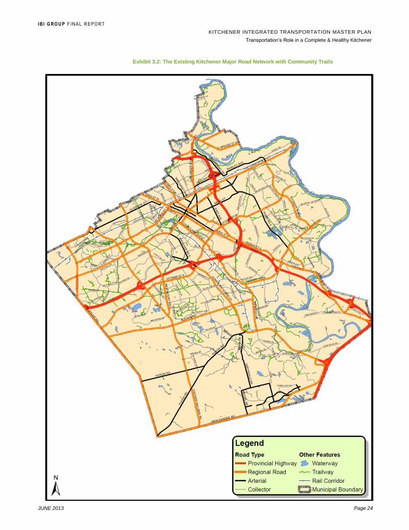
I B I G R O U P F I N A L R E P O R T
KITCHENER INTEGRATED TRANSPORTATION MASTER PLAN
Transportation‟s Role in a Complete & Healthy Kitchener
JUNE 2013 Page 24
Exhibit 3.2: The Existing Kitchener Major Road Network with Community Trails

I B I G R O U P F I N A L R E P O R T
KITCHENER INTEGRATED TRANSPORTATION MASTER PLAN
Transportation‟s Role in a Complete & Healthy Kitchener
JUNE 2013 Page 25
Key Challenges
The biggest challenge facing transportation in Kitchener today is the high rate of
private auto use and its impact on traffic volumes, speeds, travel times and
transportation costs. This auto dependency is shown by transportation
characteristics collected by the Transportation Tomorrow Survey (TTS) in 2006
compared to 1996 in Waterloo Region. In Exhibit 3.3, travel characteristics from
the 2006 Census are included just for the City of Kitchener.
Exhibit 3.3: Typical Waterloo Region Household Travel Characteristics
1996 TTS 2006 TTS 2006 Census Kitchener
Average Household Size 2.7 2.7 -
# of Vehicles per Household 1.5 1.6 -
Trips per Day 6.6 6.4 -
Mode of Travel:
Auto Driver
Auto Passenger
Transit
Cycling/Walking
70%
18%
3%
7%
71%
17%
3%
6%
77%
10%
6%
6%
Median Auto Driver Trip Length (km) 3.9 4.3
Source: Transportation Tomorrow Survey, 1996/2006, 2006 Census City of Kitchener
Community Profile
These existing Kitchener travel characteristics from the 2006 Census clearly
illustrate the auto dominance in the existing transportation system at 87% of all
daily trips, followed by 6% by transit and 6% by active transportation. The city‟s
challenge for the future is to compare these mode splits to the 2031 region-wide
targets set by the new RTMP. This includes 70% of PM Peak Hour trips by
autos (driver and passenger) across the entire Region which is a significant
reduction compared to today, augmented with significant increases in transit and
active transportation to 17% and 12% respectively.
From the feedback collected from city committees and the public during the
preparation of the TMP, other prevalent transportation challenges that Kitchener
is facing today are:
Growing traffic volume and related traffic congestion on major streets,
most notably Victoria Street, Weber Street, King Street and Fairway
Road (all Regional roads);
Neighbourhood traffic intrusion, volume and speed often resulting from
congestion on peripheral arterial streets;
Limited access to Highway 401 (for example, two interchanges serving
almost 360,000 people in the Kitchener/Waterloo area north of Highway
401);
Need for active transportation (cycling, walking) funding support;
I B I G R O U P F I N A L R E P O R T
KITCHENER INTEGRATED TRANSPORTATION MASTER PLAN
Transportation‟s Role in a Complete & Healthy Kitchener
JUNE 2013 Page 26
Increased travel distance, time and cost to new suburban
neighbourhoods;
Grand River Transit service and introduction of the Light Rail Transit
Corridor;
Changing travel and mobility needs of the aging population; and
Need for an adequate parking supply in the downtown.
3.2 Kitchener in 2031
The timeframe of the TMP is 20 years to 2031, the same as the new Draft
Official Plan (OP).
By 2031 the new Draft OP envisions a city of approximately 315,000 people, an
increase of about 90,000 residents since 2011. Growth will be based on a Plan
for Healthy Kitchener that is more walkable, more transit supportive and
ultimately more “urban” while still striving to keep a high quality of life. Some of
the characteristics of Kitchener in 2031 that will influence transportation in the
city include:
Balanced growth with an emphasis on intensification particularly in the
Urban Growth Centre (downtown), major transit station areas, nodes
and corridors;
The use of existing infrastructure including transportation will be
maximized;
Residents will have convenient access by various travel modes;
New development will be compact, efficient and vibrant, and optimizing
the use of existing and new infrastructure; and
Residents will be provided with an interconnected and continuous
natural transportation system.

I B I G R O U P F I N A L R E P O R T
KITCHENER INTEGRATED TRANSPORTATION MASTER PLAN
Transportation‟s Role in a Complete & Healthy Kitchener
JUNE 2013 Page 27
4. Strategic Transportation Planning
4.1 Alternative Strategies
The forecasting and planning of future transportation system needs in Kitchener
over the next 20 years was developed for this TMP using two different
transportation scenarios.
Transit-Oriented Future with Strategic Road Improvements (Base)
This Transit-Oriented Future is based on the approved Regional Transportation
Master Plan and so is also referred to as the Base scenario. It includes a
balanced program of investment in both transit and needed street
improvements. These strategic road improvements will be implemented to
support transit, for example by providing transit priority at signalized
intersections and bus lanes to support people and goods movement and
address deficient street capacity where required.
The Transit-Oriented Future includes improvements to conventional transit,
iExpress transit and operation of LRT service extending from north Waterloo to
the Cambridge City Centre along the central transit corridor. This and other
transit service improvements over the next 20 years are intended to shift more
local trip-making away from single-occupant autos and increase the transit mode
share in Kitchener, particularly for trips to Downtown Kitchener.
The preferred Transit-Oriented Network selected for the RTMP is expected to
result in an increase in the Region‟s transit mode use from 6% PM Peak Hour
trips in 2016 (compared to 6% of overall trips in Kitchener according to the 2006
Census), to 17.3% by 2031. This will require a transition from the basic level of
transit service in Kitchener today, to a higher quality service and the adoption of
supportive land use, active transportation, parking and Transportation Demand
Management (TDM) policies. These policies are integrated into this TMP, have
been reflected in the Region‟s Official Plan and will be considered as part of the
City‟s preparation of the new Official Plan.
Business As Usual (BAU) Future
In this alternative scenario, existing travel mode shares and associated local
travel characteristics in Kitchener would remain basically unchanged over the
next 20 years. Transit would continue to serve about 6% of trips on a typical
day for Kitchener households. The private auto would be used for about 87% of
these trips, thereby remaining very auto dependent. According to the RTMP,
this BAU scenario would result in kilometres of congested roads in the afternoon
peak hour across the three urban areas growing from 210 lane kilometres today,
to over 500 lane kilometres by 2031. The result would be significant impacts on
the movement of people and goods, neighbourhood quality of life, the natural
environment (i.e. air quality) and the economic vitality of the city.
According to the RTMP, the implications of the BAU scenario at the Regional
urban area level is a need to expand the road network by about 25% including

I B I G R O U P F I N A L R E P O R T
KITCHENER INTEGRATED TRANSPORTATION MASTER PLAN
Transportation‟s Role in a Complete & Healthy Kitchener
JUNE 2013 Page 28
the need for at least 84 new lanes of road capacity by 2031. The key problem
areas would be in the already urbanized west sections of Kitchener and
Waterloo where north-south travel demands would require as much as eight (8)
additional lanes of new arterial road capacity. Further growth in west Kitchener
and Waterloo would also need up to 14 new arterial road lanes of capacity
crossing the Westmount Road corridor.
4.2 Existing / Future Kitchener Street Network Performance
Level-of-Service (LOS)
The operational Level-of-Service (LOS) of a street link or intersection is directly
related to street performance in the network and therefore travel safety and
convenience. LOS is measured using a code system provided by the Highway
Capacity Manual 2010.4 Transportation system planning uses a combination of
traffic volume and capacity to determine a volume/capacity or v/c ratio for road
links or intersections in a roadway network, which equates to a measurement of
Level-of-Service (LOS).
Street LOS
For streets, LOS is measured by the following six levels or grades of generalized
traffic conditions to determine the quality of service.
LOS General Condition LOS General Condition
A Free Flow D Approaching Unstable Flow
B Reasonably Free Flow E Unstable Flow
C Stable Flow F Forced or Breakdown Flow
One primary objective of street network performance is to avoid or mitigate any
LOS E and F conditions. At LOS E street traffic is nearing capacity, while LOS F
is the worst condition with heavily congested flows and traffic demands
exceeding the street capacity (V/C >1.0).
Signalized Intersection LOS
For intersections, LOS uses the same six levels but is measured by vehicle
delay and queue lengths at the intersection approaches summarized as follows:5
LOS Description V/C Ratio
A No Traffic signal phase is fully utilizes, with the intersection
approach appearing open and turning movements made easily.
0 – 0.59
B Occasional signal phase is fully utilized and many phases
approach full use. Many drivers begin to feel somewhat restricted
with platoons of vehicles approaching the intersection.
0.60 – 0.69
C Operation is stable though with more frequent fully utilized signal
phases, meaning some drivers may have to wait one red signal
0.70 – 0.79
4 Highway Capacity Manual 2010 (HCM2010), Transportation Research Board
5 HCM2010
I B I G R O U P F I N A L R E P O R T
KITCHENER INTEGRATED TRANSPORTATION MASTER PLAN
Transportation‟s Role in a Complete & Healthy Kitchener
JUNE 2013 Page 29
phase and longer queues develop behind turning vehicles. This
condition is generally considered normal and acceptable in most
urban intersection design.
D Motorists experience restriction and instability of traffic flow, with
delays to short delays to approaching vehicles in the peak
periods. There is still enough signal cycles with lower demand to
permit occasional clearance of developing queues to prevent
excessive backups.
0.80 – 0.89
E Intersection capacity is reached. There are long queues upstream
of the intersection, and delays to vehicles may extend to several
signal cycles.
0.90 – 0.99
F Saturation (gridlock) occurs, with vehicle demand exceeding the
available capacity.
1.00 or greater
Key Intersection and Corridor Review
Twenty-seven (27) key intersections in Kitchener involving City and City/Region
roads were selected for modeling and analysis of future intersection operational
problems. Each was selected because it plays a key role on the road network,
involves at least one intersecting city street, is on a key city corridor and/or
exhibits an existing operational issue. Exhibit 4.1 shows the location of these 27
modelled intersections.
The City‟s street network includes many more key intersections and corridors
than those identified for this analysis. It is intended that the operational capacity
and LOS of all Regional Roads within the network will be maintained by the
Region of Waterloo through the road improvement priorities recommended in
the Regional Transportation Master Plan: Moving Forward 2031. The Regional
Plan includes 31 specific street improvements within the City of Kitchener,
mainly on Regional Roads to year 2031 including upgrades, widenings, transit
priority improvements and new streets. The Kitchener TMP identifies what
additional street capacity and operational improvements will be required on City
streets in order to maintain acceptable level of service and safety over the next
20 years.
The following summary of the strategic intersection analysis provides a
conceptual indication of expected city road network improvements expected in
2031. Two overall indicators of this network performance were extracted from
the Region‟s demand model:
1. transit mode share; and
2. congested lane kilometres (lane-km).
Transit Mode Share
Transit mode share in the region‟s model was based on 2006 Transportation
Tomorrow Survey (TTS) data. Exhibit 4.2 and Exhibit 4.3 show transit mode
shares extracted for trips within Kitchener and to/from Downtown Kitchener. The
matrix details the percentage of trips that uses transit from trip origins to
destinations.
As shown in Exhibit 4.2, 7.1% of AM peak hour trips within the City are
using transit, which decreases to 3.5% in the PM peak hour (likely

I B I G R O U P F I N A L R E P O R T
KITCHENER INTEGRATED TRANSPORTATION MASTER PLAN
Transportation‟s Role in a Complete & Healthy Kitchener
JUNE 2013 Page 30
because school trips fall outside of the PM peak hour). The 2009 transit
mode share for trips to Downtown Kitchener is 13.8% in the AM peak
hour, and the transit mode share for trips leaving Downtown Kitchener is
12.4% in the PM peak hour. Within Downtown Kitchener, trip distances
are too short to provide an accurate mode share.
Exhibit 4.1: Key Intersections Analyzed (refer to Exhibit 4.5)

I B I G R O U P F I N A L R E P O R T
KITCHENER INTEGRATED TRANSPORTATION MASTER PLAN
Transportation‟s Role in a Complete & Healthy Kitchener
JUNE 2013 Page 31
Exhibit 4.3 indicates that strong growth is planned in the transit mode
share from 2009 to 2031. Trips to Downtown Kitchener increase to 33.9%
transit mode share in the AM peak hour and 49.9% departing Downtown
Kitchener in the PM peak hour. Total mode share in the City increases to
11.3% in the AM peak hour and 16.1% in the PM peak hour.
Exhibit 4.2: Transit Mode Share, 2009 Scenario – AM Peak Hour (PM Peak Hour)
From To
Kitchener Downtown Kitchener
Kitchener 7.1% (3.5%) 13.8% (4.5%)
Downtown Kitchener 7.6% (12.4%) n/a
Exhibit 4.3: Transit Mode Share, 2031 Base Scenario – AM Peak Hour (PM Peak Hour)
From To
Kitchener Downtown Kitchener
Kitchener 11.3% (16.1%) 33.9% (15.7%)
Downtown Kitchener 10.0% (49.9%) n/a
Congested Lane-Km
Congested lane-km on arterial roads, both Regional and City of Kitchener, is an
indication of city-wide performance and congestion levels. For analysis
purposes, congested lane-km was defined as links with volume to capacity (V/C)
ratio of 0.9 and greater.
The total arterial lane-km in Kitchener is 958 in 2009, increasing to 1042 under
the RTMP plan for 2031. Exhibit 4.4 summarizes lane-km analysis for Base and
BAU conditions in 2009 and 2031. The following trends were identified from this
analysis:
Congested lane-km are expected to increase by at least
19% by 2031 for either Base Transit-Oriented or BAU
conditions;
The lower BAU transit mode share would result in higher
congested lane-km than the Base Transit-Oriented
conditions.
In all horizons, the PM peak hour experienced more
congested lane-km.
Comparing 2031 Base to BAU scenarios, the PM peak hour
had a greater congested lane-km increase than the AM peak
hour. The larger increase occurs because the difference
between Base and BAU transit mode share is higher in the
PM peak hour, a 37.5% increase versus the AM peak hour
with a 20.1% increase.

I B I G R O U P F I N A L R E P O R T
KITCHENER INTEGRATED TRANSPORTATION MASTER PLAN
Transportation‟s Role in a Complete & Healthy Kitchener
JUNE 2013 Page 32
Exhibit 4.4: Lane-km Summary Results
Period
Total Lane-km Congested Lane-km Growth
2009 2031 2009 2031
Base
2031
BAU
2009 to 2031
Base
2009 to 2031
BAU
2031 Base to
2031 BAU
AM Peak Hour 958 1,042 145 172 223 19% 54% 30%
PM Peak Hour 958 1,068 163 215 289 32% 77% 34%
Overall, the BAU results in higher traffic flows on the majority of city
streets, and a shift in auto trips to provincial Highway 7/8 as congestion
on arterial streets in the City causes longer travel times on arterials. A
much smaller number of streets could experience decreased traffic flow in
the BAU scenario, again due to diversion of trips away from congested
links.
The intersection analysis shows that the following analysed intersections
currently operate at deficient Level-of-Service E or F conditions on City streets
(C) and Regional roads (R) during the AM and PM peak hours in Kitchener
based on available traffic counts and existing intersection configurations and
signal timing.
Exhibit 4.5: Existing Deficient Intersections (refer to Exhibit 4.1)
EXISTING AM PEAK HOUR EXISTING PM PEAK HOUR
4. Queen‟s Blvd (C) / Westmount Rd (R)
10. Victoria St (R) / Park St (C)
21. Wellington St (C) / Riverbend Dr (C)
2. Queen‟s Blvd (C) / Fischer-Hallman Rd (R)
3. Glasgow St (C) / Westmount Rd (R)
7. Block Line Rd (C) / Strasburg Rd (C)
13. Wabanaki Dr (C) / Manitou Dr (R)
17. Fairway Rd (R) / Wilson Ave (C)
21. Wellington St (C) / Riverbend Dr (C)
25. Franklin St (C) / Weber St (R)
26. Greenbrook Dr (C) / Westmount Rd (R)
27. Pioneer Dr (C) / Doon Village Rd (C)
Major Street Corridors
Currently in Kitchener, no major city street corridors (not including Regional
Road corridors such as Fairway Road or Victoria Street) have significant
capacity or major operational issues, and congestion is limited mainly to peak
hour locations. However, a number of specific intersections in Kitchener listed in
Exhibit 4.5 currently experience peak hour operational deficiencies, and others
that were analysed now operate at LOS C and D, indicating that further
operational deterioration and remediation can be expected by 2031.
Modeling and analysis of 2016 and 2031 conditions illustrates moderate
congestion growth in the city under the Base scenario with increased transit
mode shares. In general, signal timing changes can maintain LOS through 2016,
but by 2031 some geometric changes are required to intersections around the
city to maintain level of service.

I B I G R O U P F I N A L R E P O R T
KITCHENER INTEGRATED TRANSPORTATION MASTER PLAN
Transportation‟s Role in a Complete & Healthy Kitchener
JUNE 2013 Page 33
Three major City of Kitchener street corridors are also forecasted to be deficient
under peak hour conditions in 2031, namely Strasburg Road, Block Line Road,
and the Wellington Street/Shirley Avenue corridor that will be connected to the
new planned Highway 7 Extension. This assumes that the Region‟s Base
transportation scenario, with increased transit ridership and a decrease in the
growth of private auto use, is achieved by 2031. It also reflects forecasted traffic
volumes by 2031 under a Do Nothing scenario with no capacity or operational
improvements made to these three corridors. City plans to improve and extend
Strasburg Road and Block Line Road, discussed further in Section 4.4, are
intended to address the forecasted deficiencies. The Regional TMP
recommends that the province build the new Highway 7 by 2021 to address
expected operational and capacity issues on Highway 7 / Victoria Street.
4.3 Implications of the Business As Usual (BAU) Future
Based on a strategic analysis of major street corridors in Kitchener, no City
corridors operate poorly today. By 2016, congestion is still limited to isolated
locations, but as shown on Exhibit 4.6, by 2031 in the Base transit-oriented
scenario, high congestion levels are expected along the following City corridors:
Strasburg Road from Ottawa Street S to Huron Road;
Block Line Road from Strasburg Road to Homer Watson
Blvd; and
Wellington Street / Shirley Avenue corridor from Lancaster
Street to east of Riverbend Drive.
Sensitivity analysis conducted for this study on an alternative Business As
Usual (BAU) scenario would maintain the 2009 transit mode share
through to 2031. It indicates that under this scenario with no change in
alternative transportation mode use, the following additional City road
corridors would also experience operational and capacity issues:
Glasgow Street from Fischer-Hallman Road to Belmont
Avenue;
Block Line Road from Strasburg Road to Westmount Road;
and
Downtown Kitchener along Weber Street and King Street.
These findings suggest that under the Base scenario, the current
Kitchener road network can generally accommodate forecasted traffic
growth up until 2016 with 16 of the modelled intersections operating at
LOS D or better, but 11 operating at an unacceptable LOS E/F during one
or more peak hours of the day.
By 2031, the number of deficient intersections is expected to remain at
11, but would double to 21 if the BAU scenario was followed with no
change in the transit and active transportation mode use

I B I G R O U P F I N A L R E P O R T
KITCHENER INTEGRATED TRANSPORTATION MASTER PLAN
Transportation‟s Role in a Complete & Healthy Kitchener
JUNE 2013 Page 34
Exhibit 4.6: Congested Corridors
2031 Forecasted BASE Scenario
2031 Forecasted BAU Scenario
I B I G R O U P F I N A L R E P O R T
KITCHENER INTEGRATED TRANSPORTATION MASTER PLAN
Transportation‟s Role in a Complete & Healthy Kitchener
JUNE 2013 Page 35
4.4 Transportation Needs & Opportunities
Integrated Transportation System
An integrated approach to land use and transportation planning is essential in
building an efficient and effective transportation system that supports a
sustainable and vibrant city. It is key in supporting the Kitchener‟s urban
structure and to achieve its intensification and connectivity goals. An integrated
transportation system also promotes transportation choices and supports an
active, healthy community.
The private automobile is the predominant mode of travel in Kitchener, with
about 88% of trips originating in Kitchener made by cars (auto driver and
passenger)6. Transit and cycling/walking mode shares are 3% and 6 %
respectively, recorded as 6 % for each in the 2006 Census (see Exhibit 3.3).
Breaking the cycle of automobile dependence is not an easy task. In addition,
travel patterns and needs will grow with the City‟s expected growth of almost
100,000 new people and 40,000 new jobs by 2031. Where and how this growth
is accommodated will have a significant impact on transportation needs.
Directing growth towards the urban growth centre, and the mixed use corridors
and nodes will support opportunities to reduce automobile dependence and
maximize alternative travel modes.
Despite the emphasis on intensification, some of the City‟s forecasted growth
will be in areas outside the existing built-up area, particularly areas that are not
well served by transit. This highlights the need to focus on an integrated
approach where the private automobile plays a balanced role (i.e. sustainability
does not mean no private vehicles) and the focus is on providing mobility
choices and programs to encourage higher-occupancy vehicle trips.
The City‟s Comprehensive Review of Employment Lands Study forecasts
greater growth by 2029 in population-related employment (service) jobs,
compared to employment sector industries such as manufacturing and
transportation/warehousing. This growth and shift towards more service-related
employment will need to be considered as these employment sectors have
different locational characteristics and transportation needs. For example,
transportation needs for manufacturing and transportation/warehousing
employment lands should focus on an efficient goods movement network and
higher-occupancy vehicle travel opportunities for employees. On the other
hand, transportation needs for retail, educational services and health-related
services should emphasize reliable public transit service, multimodal access and
travel choices. This again highlights the need for a well-balanced transportation
system that is integrated with land-use planning and provides travel options by
different planning areas.
Opportunities that further enhance an integrated transportation system for
Kitchener also exist with the recent introduction of GO Transit commuter rail
service from Kitchener to Union Station in downtown Toronto. Current studies
are underway to explore the potential for additional peak period service and
potential all-day, two-way service between Kitchener and areas along the GO
Transit Kitchener rail line.
6 2006 Transportation Tomorrow Survey, trips with planning district of trip origin in Kitchener.

I B I G R O U P F I N A L R E P O R T
KITCHENER INTEGRATED TRANSPORTATION MASTER PLAN
Transportation‟s Role in a Complete & Healthy Kitchener
JUNE 2013 Page 36
City Urban Structure Nodes and Corridors
As support for the development of the new Official Plan and as a
recommendation of the Kitchener Growth Management Strategy (KGMS), the
City conducted a detailed review of its intensification areas, in particular the
Mixed Use Nodes and Corridors that are part of the framework of the City‟s
urban structure. The Comprehensive Review of Intensification Areas (CRIA) was
completed in May 2011, and confirmed that the current nodes and corridors
planning model is reliable and effective for achieving intensification.
The CRIA study proposed a revised urban structure based on connectivity
between designations via transit corridors which reflects and supports provincial,
regional and city policies on growth and intensification. Some of the City‟s
nodes are intended to have a mix of residential, commercial and institutional
land uses and “support transit use and pedestrianism”. However, there are
opportunities to further enhance these areas to address all modes of
transportation.
A “Complete Streets policy could be developed for these activity nodes to
provide a balanced and safe environment for drivers, pedestrians, cyclists and
transit-users alike. The City‟s corridors will have varying transportation needs to
support the planned function and intensification opportunities for these corridors.
Transportation strategies in this TMP need to focus on the compact, transit-
supportive elements of the corridors and plant the seed to attract higher mode
shares of transit users, pedestrians and cyclists. Priority should be given for
development in these areas that strengthen linkages between different modes
and surrounding residential and employment generators.
The challenge for some nodes and corridors will be the integration of strategies
to reduce single occupant vehicle use in these areas that have an automobile-
oriented focus, continue to provide a network for the efficient transport of goods
movement, all while not undermining the goals for sustainability and mobility
choices.
Walking Facilities
Exhibit 4.7 shows the AM peak period (6:00 a.m.-9:00 a.m.) mode share by trip
distance (average straight-line) for trips originating in Kitchener (2006
Transportation Tomorrow Survey, TTS). As noted previously, auto trips
dominate, except for the shortest trips. Walking trips are common for short trips
with 49% mode share for trips less than 1 km, decreasing to 1% for trip lengths
of 3-4 km. This highlights the opportunities to increase sustainable
transportation mode shares by reducing trip lengths and encouraging non-
motorized travel for shorter trips.

I B I G R O U P F I N A L R E P O R T
KITCHENER INTEGRATED TRANSPORTATION MASTER PLAN
Transportation‟s Role in a Complete & Healthy Kitchener
JUNE 2013 Page 37
Exhibit 4.7: Mode Share by Average Straight-Line Trip Distance, AM Peak, TTS 2006
In 2005, the City adopted its Kitchener Pedestrian Charter, which set out six
principles about the value of walking: 1) Accessibility, 2) Equity, 3) Health and
Well-Being, 4) Environmental Sustainability, 5) Personal and 6) Community
Safety, and Community Cohesion and Vitality. The Charter calls for support of
walking environment and infrastructure for pedestrians to feel safe and
comfortable, and that provide for convenient access to services and amenities.
The TMP provides further opportunities to incorporate pedestrian facilities in
transportation planning and enhance the walking environment.
As most trips begin and end by walking, and given the practical limitation of
speed and time for longer trips, the pedestrian network needs to be fully and
effectively integrated with the broader transportation network including transit.
Provision of sidewalks and pedestrian amenities also need to be integrated
wherever possible with roadway design and classification, and assigned
appropriate priority levels to support the proposed street type and adjacent land
use typologies. For example, where sufficient road right-of-way is available,
sidewalks on both sides of the street should be accommodated with higher
standard features such as separated boulevards and street furniture along both
City and Regional arterials.
Cycling Facilities
The Kitchener Cycling Master Plan (KCMP) identifies a long-term cycling
network of routes and corridors that provides cyclists a safe, comfortable and
connected environment, and promotes cycling as a viable mode of travel in the
City and for recreation. The recommended cycling network will add 114 km of
bikeways to the existing 45 km, for a total of 159 km including Regional cycling
routes on City streets. In addition, bikeways are complemented with 240 km of
primary and secondary multi-use pathways (120 km existing and 120 km
proposed) outside of the road right-of-way.
In terms of policies, the KCMP recommends changes to Official Plan cycling
policies, road classification policies to consider needs of cyclist and new
additional policies. It also recommends a signage strategy, in partnership with
0%
10%
20%
30%
40%
50%
60%
70%
80%
90%
100%
0 1 2 3 4 5 6 7 8 9 > 10
Mo
de S
hare
Trip Distance (km)
Other
Cycle
Walk
Auto Passenger
Auto Driver
Transit

I B I G R O U P F I N A L R E P O R T
KITCHENER INTEGRATED TRANSPORTATION MASTER PLAN
Transportation‟s Role in a Complete & Healthy Kitchener
JUNE 2013 Page 38
the Region and neighbouring municipalities, to increase visibility of the cycling
network.
The Multi-use Pathways and Trails Master Plan also proposes new OP policies
to ensure the implementation of an integrated “off-road” network of cycling and
pedestrian routes throughout Kitchener. The City has an opportunity to build
upon the recommendations of the KCMP and the Multi-use Pathways and Trails
Master Plan, and further support cycling and active transportation through
enabling OP and TMP policies and strategies.
Exhibit 4.8 shows cycling mode shares are highest among 4-6 km long trips. In
the morning peak period, more than half the trips that originate in Kitchener are
less than 5 km and about 22% are less than 2 km (Exhibit 4.8). As with
pedestrian facilities, opportunities exist to promote cycling as a viable
transportation mode for shorter trips and to integrate cycling facilities with transit
service to provide cyclists with mobility choices for moderate and longer trips. In
addition, students represent a potential market to increase cycling in Kitchener.
As shown in Exhibit 4.8, cycling has a low mode share of home-based school
trips, even for shorter trips less than 5 km. There are opportunities to encourage
cycling through programs that promote the safety and health benefits of cycling
to school – reduced auto congestion around schools, active lifestyle for
students, etc.
Exhibit 4.8: Cycling Trips and Mode Share by Trip Distance, AM Peak, TTS 2006.
Trip Length Cycle Trips Total Trips Cycling Mode Share
All Trips
< 2 km 580 22,300 2.6%
2-5 km 1,900 33,100 5.7%
+ 5 km 1,450 47,750 3.0%
Total 3,950 103,150 3.8%
School Trips
< 2 km 110 8,600 1.3%
2-5 km 175 8,150 2.1%
+ 5 km 25 4,325 0.6%
Total 310 21,075 1.5%
Year-round maintenance of Active Transportation facilities, including sidewalks,
cycling lanes and routes, primary multi-use pathways and trails, is important to
ensure accessibility and safety of users. This is important as reliability can
factor into an individual‟s choice of travel (e.g. those who would cycle more if
they felt the roadway was safer, well-maintained and clear of obstacles such as
snow).
Accessibility Standards
The draft June 2011 City Official Plan notes that although there was no one
dominating age group in 2006, the City continues to attract younger populations
while also being home to a large population of aging adults. This creates the
I B I G R O U P F I N A L R E P O R T
KITCHENER INTEGRATED TRANSPORTATION MASTER PLAN
Transportation‟s Role in a Complete & Healthy Kitchener
JUNE 2013 Page 39
need to balance transportation priorities to enhance transit, walking and cycling
as viable modes of travel for commuters, and to provide services for people with
limited mobility, disabilities and special needs.
The City‟s principles relating to pedestrian accessibility are contained in three
documents, namely the City‟s Pedestrian Charter, the City of Kitchener/City of
Waterloo Joint Accessibility Plan and the Kitchener Urban Design Manual.
The Pedestrian Charter includes six principles needed by pedestrians to ensure
walking is a safe, comfortable and convenient mode of urban transportation:
Accessibility;
Equity;
Health and Well-Being;
Environmental Sustainability;
Personal and Community Safety; and
Community Cohesion and Vitality
Some of the actions recommended by the Pedestrian Charter to create an
environment that supports walking that are integrated into this TMP are (refer to
Charter for all actions):
Provide a walking environment within the public right-of-way and in
public parks that encourages walking;
Support and encourage the planning, design and development of a
walking environment in public and private spaces;
Provide and maintain infrastructure that gives pedestrians safe and
convenient passage while walking along and crossing streets;
Set policies that reduce conflicts between pedestrians and other users
of the public right-of-way; and
Advocate for improved provincial and federal regulations and funding to
support the City‟s ability to improve the pedestrian environment.
The City of Kitchener/City of Waterloo Joint Accessibility Plan was prepared in
order to meet the obligations of the Ontarians with Disabilities Act, 2001 (ODA)
and the Accessibility for Ontarians with Disabilities Act, 2005 (AODA). The Plan
describes the actions each of the participating municipalities is taking to support
accessibility for all, and the areas to be reviewed. It reports on the steps that are
being taken to identify, prevent and remove barriers to accessibility in these
communities.
The Kitchener Urban Design Manual (2010) provides standards to ensure new
developments and redeveloped sites are barrier-free and universally accessible
to all users. The manual includes standards and requirements for barrier-free
parking, pedestrian loading areas, sidewalks, entrances and doorways, and
other amenities (e.g. trails, playgrounds, picnic areas, etc.). In addition, the
manual includes standards to develop barrier-free environments along

I B I G R O U P F I N A L R E P O R T
KITCHENER INTEGRATED TRANSPORTATION MASTER PLAN
Transportation‟s Role in a Complete & Healthy Kitchener
JUNE 2013 Page 40
pedestrian- and transit-oriented developments to increase and improve
accessibility to transit. Specifically:
Barrier-free pedestrian access to transit stops and links to transit stops
provided in either concrete or asphalt;
Sidewalks along both sides of transit routes and according to the City
Sidewalk Policy;
Improvements of microclimate amenities: canopies, landscaping,
arcades;
Local road pattern with direct pedestrian access to transit stops and
transfer points;
Adequate lighting and year-round maintenance of pedestrian links to
transit stops;
95% of residents, jobs and other activities within 450m walking distance
to transit stops;
Integrate neighbourhood features and public spaces with bus stop
locations; and,
Direct, convenient and barrier-free access between sidewalk,
shelter/waiting area and loading/unloading zones.
Overall, accessibility is a key factor in people‟s choice of a mode of travel. The
City‟s strategies to reduce automobile dependence and promote sustainable
transportation choices will need to build on and reflect these accessible
standards. Providing users a universally accessible and barrier-free access to
sustainable modes will have a significant impact on people‟s willingness to take
transit, walk or cycle.
Transit-Oriented Development
The City has an opportunity to build upon transit-supportive policies developed
for mixed use corridor and nodes, and implement these for all developments.
New development and redeveloped sites should incorporate urban design
elements of compact, pedestrian-oriented site design that are conducive to
transit, pedestrians and cyclists while accommodating car travel with limited
congestion.
Confirmation of Key Street Network Improvements
As previously reported in Section 4.2, currently in Kitchener no major City of
Kitchener street corridors have any significant capacity or operational issues,
and congestion is limited to peak hour conditions. However, modeling and
analysis of 2016 and 2031 traffic volumes and LOS conditions show moderate
congestion growth in the city under the Base scenario with increased transit
mode shares. While signal timing changes can maintain LOS through to 2016,
by 2031 some geometric improvements are required to intersections around the
city to maintain level of service.

I B I G R O U P F I N A L R E P O R T
KITCHENER INTEGRATED TRANSPORTATION MASTER PLAN
Transportation‟s Role in a Complete & Healthy Kitchener
JUNE 2013 Page 41
Note: City of Kitchener Geographic Street Direction
Compass directions used in this TMP are based on the
arrangements shown here.
The three types of major roadway/highway travel routes in
Kitchener expected to have deficient capacity under peak hour
conditions by 2031 are:
1. Routes that are either undergoing study or are approved by the
City to address existing or forecasted road deficiencies. This TMP
has re-confirmed the need for these projects;
2. Additional capacity enhancements based on analysis conducted
as part of this TMP. This is based on achieving the Region‟s Base
scenario by 2031 with increased transit ridership. Implementation of these
recommended capacity and/or operational improvements will be required to
address forecasted network deficiencies, and are expected to require Municipal
Class Environmental Assessment approval; and
3. Related to Ministry of Transportation projects on provincial highways within
Kitchener.
Type 1 Projects – Under Study or Approved
South Kitchener: Strasburg Road Extension from Rush Meadow Street to New
Dundee Road with Associated Collector Extensions – Traffic growth
assessments conducted as part of this TMP and the Strasburg Road Extension
Municipal Class EA (SNC Lavalin) confirm a considerable amount of planned
suburban growth in the Rosenberg and Huron South communities in south
Kitchener (ultimately 30,000 people and jobs).7 This area is currently served by
two north-south Regional arterial roads, Homer Watson Blvd. and Fischer-
Hallman Road.
The need to extend additional north-south road capacity south of Huron Road
into this designated growth area south to New Dundee Road has already been
confirmed in the Strasburg Road EA to serve planned south Kitchener growth
and associated travel demand. The technically preferred alignment of this
required extension was approved in May 2013 by City Council from north of
Stauffer Drive to new Dundee Road, and is shown as Alternative „W1‟ on Exhibit
4.9. It is planned as a four lane arterial road with multi-use trails on both sides.
Most of the south section of Strasburg Road extension will fall outside of the
Region‟s proposed countryside line. There will also likely be a new alignment of
Robert Ferrie Drive proposed in the near future. Approval of the extension EA is
expected in the fall of 2013.
The extended Strasburg Road is forecast to carry Average Annual Daily Traffic
(AADT) volumes of 8,000 – 11,000 vehicles by 2016 which can be served by
one lane of traffic per direction, and 15,000 – 22,000 by 2031 requiring two
lanes per direction. The EA also notes that the need for the Strasburg Road
extension was first confirmed in the Doon South-Brigadoon Transportation
Network and Corridor Study that concluded the existing network would not be
able to support the increased traffic demand associated with project growth.
7 Rosenberg Secondary Plan, August 2011
E
N
W
S

I B I G R O U P F I N A L R E P O R T
KITCHENER INTEGRATED TRANSPORTATION MASTER PLAN
Transportation‟s Role in a Complete & Healthy Kitchener
JUNE 2013 Page 42
The RTMP also recommends the extension to relieve future demand on Homer
Watson Blvd., Huron Road and Fischer-Hallman Road.8 The cost for a
Strasburg Road extension is mostly DC eligible.9
The TMP incorporates the need to enhance north-south arterial road capacity in
south Kitchener in response to city growth and associated transportation needs
in this area. Therefore, is I shown as a „preferred alignment‟ in Exhibit 4.9, and
will be subject to approval of the final Municipal Class EA.
Exhibit 4.9: Strasburg Road Extension Technically Preferred Alignment
8 Draft Environmental Study Report (ESR), Strasburg Road Extension Municipal Class EA, SNC Lavalin, April 2012
9 2009-2010 City of Kitchener Growth Management Plan
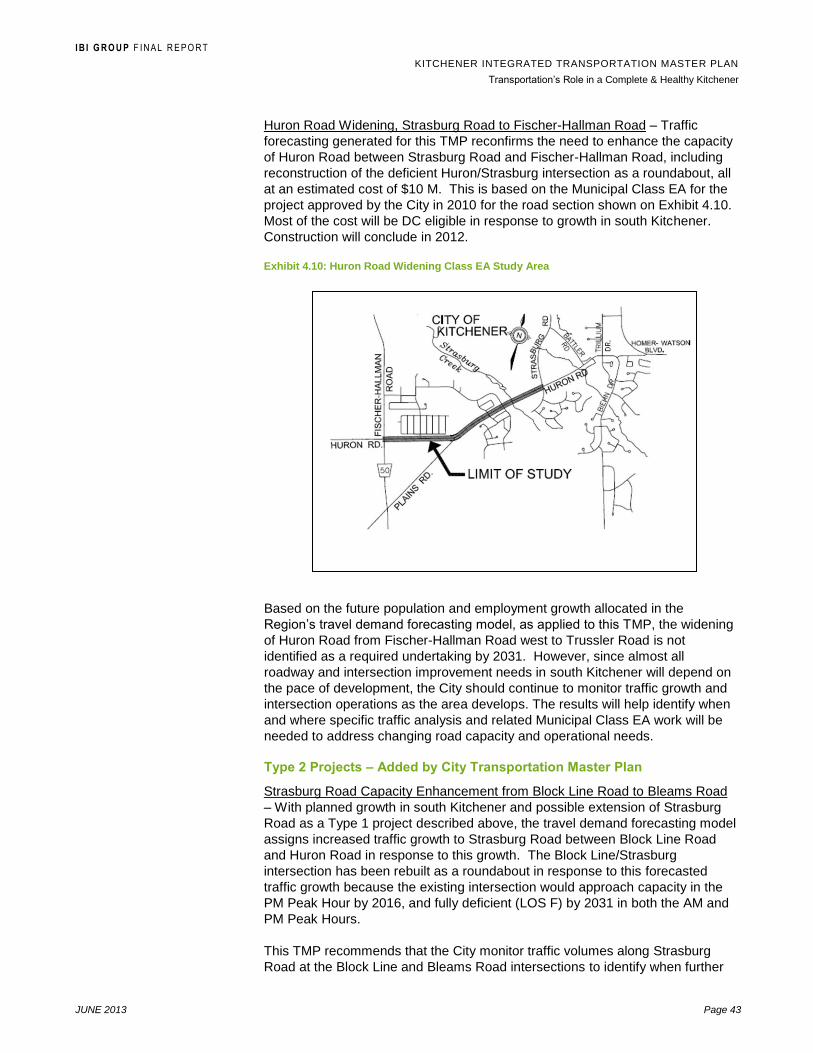
I B I G R O U P F I N A L R E P O R T
KITCHENER INTEGRATED TRANSPORTATION MASTER PLAN
Transportation‟s Role in a Complete & Healthy Kitchener
JUNE 2013 Page 43
Huron Road Widening, Strasburg Road to Fischer-Hallman Road – Traffic
forecasting generated for this TMP reconfirms the need to enhance the capacity
of Huron Road between Strasburg Road and Fischer-Hallman Road, including
reconstruction of the deficient Huron/Strasburg intersection as a roundabout, all
at an estimated cost of $10 M. This is based on the Municipal Class EA for the
project approved by the City in 2010 for the road section shown on Exhibit 4.10.
Most of the cost will be DC eligible in response to growth in south Kitchener.
Construction will conclude in 2012.
Exhibit 4.10: Huron Road Widening Class EA Study Area
Based on the future population and employment growth allocated in the
Region‟s travel demand forecasting model, as applied to this TMP, the widening
of Huron Road from Fischer-Hallman Road west to Trussler Road is not
identified as a required undertaking by 2031. However, since almost all
roadway and intersection improvement needs in south Kitchener will depend on
the pace of development, the City should continue to monitor traffic growth and
intersection operations as the area develops. The results will help identify when
and where specific traffic analysis and related Municipal Class EA work will be
needed to address changing road capacity and operational needs.
Type 2 Projects – Added by City Transportation Master Plan
Strasburg Road Capacity Enhancement from Block Line Road to Bleams Road
– With planned growth in south Kitchener and possible extension of Strasburg
Road as a Type 1 project described above, the travel demand forecasting model
assigns increased traffic growth to Strasburg Road between Block Line Road
and Huron Road in response to this growth. The Block Line/Strasburg
intersection has been rebuilt as a roundabout in response to this forecasted
traffic growth because the existing intersection would approach capacity in the
PM Peak Hour by 2016, and fully deficient (LOS F) by 2031 in both the AM and
PM Peak Hours.
This TMP recommends that the City monitor traffic volumes along Strasburg
Road at the Block Line and Bleams Road intersections to identify when further

I B I G R O U P F I N A L R E P O R T
KITCHENER INTEGRATED TRANSPORTATION MASTER PLAN
Transportation‟s Role in a Complete & Healthy Kitchener
JUNE 2013 Page 44
capacity optimization or enhancement and intersection improvements may be
required on this two lane section of Strasburg Road. If capacity enhancement is
needed by widening this section of Strasburg Road to two lanes per direction (4
lane road), this may be done in one of two ways:
The on-street parking and bike lanes could be removed and the road
restriped with four travel lanes, requiring completion of a Schedule B
Class EA. This would require extensive consultation with the
surrounding neighbourhood and abutting property owners; or
Alternatively, the parking and bike lanes could be retained, requiring
road widening to provide four travel lanes requiring completion of a
Schedule C Class EA depending on the construction cost. Adding one
lane per direction to this 1100 m section of Strasburg Road from Block
Line Rd. to Bleams Rd. would cost in the order of $3.5 M. It would also
involve fronting low density residential property, while to the south
Strasburg Road is currently four lanes through the Huron Business Park
Southwest Kitchener Urban Area Study Community Master Plan – Development
plans for the southwest urban growth area of Kitchener are presented in Official
Plan Amendment (OPA) No. 90 and the Rosenberg Secondary Plan. The Plan
includes Fischer-Hallman Road as a future transit corridor, and a proposed new
mixed use corridor along Fischer-Hallman Road south of Bleams Road. OPA
No. 90 also recommended that the TMP identify the potential for a future east-
west collector road that would connect Fischer-Hallman Road with a future
extension of Strasburg Road described previously in this section. According to
the OPA, this collector road could help offset traffic along Fischer-Hallman Road,
enhance the overall transportation network in south Kitchener.
Based on a review of the physical extent of planned urban growth in OPA No.
90, the Rosenberg Secondary Plan and the existing Official Plan (Map 5), the
TMP concludes that the preferred location of a new east-west collector road
linking a Strasburg Road extension to Fischer-Hallman Road would be along or
in close proximity to the existing County Side Line in this area. This alignment
would connect to Strasburg Road at a location between Biehn Drive and Robert
Ferrie Drive extension as shown in Exhibit 4.11, with a more specific alignment
to be determined through a future EA.
Any alignment of this link to the south would be located beyond the Country Side
Line, and therefore have no transportation system value as this area is
designated Agricultural. Alternatively, an alignment north of the existing Country
Side Line would risk natural environment impacts.
West of Fischer-Hallman Road, further urban growth is also being planned in
southwest Kitchener as part of the Rosenburg Community Secondary Plan , with
a planned transportation network shown on Exhibit 4.12. This includes the
Region‟s planned road and operational improvements on Fischer-Hallman Road,
plus transit service enhancements as a high frequency bus corridor. To the
west, new major and minor collector roads are planned as shown in Exhibit 4.12
to provide a direct connection to Fischer-Hallman Road, Huron Road and
Bleams Road. This and other internal roadways would be developed as part of
the land subdivision approval process.

I B I G R O U P F I N A L R E P O R T
KITCHENER INTEGRATED TRANSPORTATION MASTER PLAN
Transportation‟s Role in a Complete & Healthy Kitchener
JUNE 2013 Page 45
Exhibit 4.11: South Kitchener Additional Collector Road
Exhibit 4.12: Transportation: Southwest Urban Area Secondary Plan
Source: Rosenberg Secondary Plan, August 2011, City of Kitchener

I B I G R O U P F I N A L R E P O R T
KITCHENER INTEGRATED TRANSPORTATION MASTER PLAN
Transportation‟s Role in a Complete & Healthy Kitchener
JUNE 2013 Page 46
Block Line Road Capacity Enhancement from Strasburg Road to Homer Watson
Blvd. - The Block Line Road Extension now under construction will create a new
continuous east-west arterial road corridor across the south part of Kitchener,
extending from Westmount Road easterly to Woolwich Township via the new
Fairway Road extension and bridge over the Grand River connecting to
Regional Road 17/Fountain Street N. This extension will be a primary access
route for the Regional Airport, the Breslau area and connection to Guelph. It will
also act as an alternative route to Ottawa Street and Bleams Road. For these
reasons, the forecasting model is predicting traffic growth along the extended
Block Line Road between Strasburg Road and Courtland Avenue that results in
deficient route and Block Line/Strasburg intersection LOS.
Under these conditions, the need and justification to provide two lanes per
direction (4 lanes) on Block Line Road between Strasburg Road and Homer
Watson Blvd. requires further, more specific traffic and design analysis currently
being conducted by city staff. Since this road section was originally four lanes
and later changed to the two lane configuration, revering it back to four lanes is
not viewed as a change in the original road capacity and therefore the revision
would not require completion of a Class EA.
The estimates cost to revert this approximately 800 m length of Block Line Road
to four lanes is $2.5 M depending on the design, with restriping being a much
less costly option. Also, the travel demand forecasting conducted for this Master
Plan shows that if the BAU scenario is followed, the need for further capacity
enhancement on Block Line Road could extend west to Westmount Road.
Type 3 Projects – Related to Ministry of Transportation Initiatives
Wellington Street N / Shirley Avenue Capacity Enhancement from Lancaster
Street to East of Riverbend Drive - Improvements that the city has made to
Bingemans Centre Drive now create an alternative route to Victoria
Street/Highway 7 extending from Lancaster Street West to Shirley Drive. This
results in the travel demand forecasting model assigning more traffic to
Wellington Street North to the point where the Wellington/Riverbend intersection
would be deficient in the AM and PM Peak Hours by 2016. This all-way stop
controlled intersection already experiences delays during peak periods but since
it is controlled by MTO as part of the Highway 7 corridor, the city is limited in
what improvements they can make.
The forecasting model also predicts continuing peak period operational issues
along Highway 7/Victoria Street that the addition of the new planned Highway 7
does not address. If the Wellington/Shirley corridor continues to be used as a
Victoria Street reliever, the City would have to conduct further traffic
assessments to determine how to optimize or enhance associated road and
intersection capacity.
Highway 401 Access – The Regional TMP conducted a preliminary assessment
of alternative ways to improve access to Highway 401 in south Kitchener. The
following three alternatives were short-listed:
Trussler Road at a new interchange;
Fischer-Hallman Road connection to new Trussler Road interchange;
and

I B I G R O U P F I N A L R E P O R T
KITCHENER INTEGRATED TRANSPORTATION MASTER PLAN
Transportation‟s Role in a Complete & Healthy Kitchener
JUNE 2013 Page 47
Fischer-Hallman Road connection to Regional Road 97 (Cedar Creek
Road) interchange.
All three were recommended to be carried forward for a more detailed
evaluation as part of a subsequent Municipal Class EA. However, it should be
noted that in the Regional TMP, major capacity and operational improvements to
Trussler Road are not required within the plan‟s 20 year planning horizon based
on the amount and allocation of population and employment growth in south
Kitchener by 2031. It is included only as a “mature state” improvement expected
beyond the 20 year timeframe.
Since this Kitchener TMP project has used the same travel demand forecasting
model as applied to the RTMP, it comes to the same conclusion that new
Highway 401 access along any of the above-noted three alignments is not
warranted by 2031 purely on the basis of population and employment growth.
However, the rationale for such a connection to serve future goods movement in
Kitchener and the overall Region may be made based on further goods
movement considerations and truck demand forecasting. The RTMP
recommends that this possibility be confirmed as part of a subsequent Municipal
Class EA study for Highway 401
access improvements. Therefore,
this TMP recommends that further
route planning of a new Highway
401 connection in south Kitchener
should be conducted mainly for
long-term corridor protection
purposes as the southwest area
develops. As shown by Exhibit
4.13, the City is looking to the
Regional TMP process to address
Highway 401 connection question.
4.13: Southwest Urban Area Studies, Potential Transportation Routes for Consideration
Strategic Intersection
Improvements – Previous Exhibit
4.5 of this TMP lists 11
intersections in Kitchener that
involve at least one city street link currently operating with deficient conditions.
These deficiencies can be addressed with optional treatments ranging from
signal timing adjustments through to addition of exclusive turn lanes and
roundabouts. These can all be implemented as Schedule A+ pre-approved or
Schedule B Municipal Class EA projects depending on the construction cost.
The methodology used to identify future intersections needing improvements in
order to maintain level of service D or better employed the Region‟s travel
demand forecasting model. For the 2016 Base scenario used in the RTMP, all
analysed intersections are shown to maintain LOS D or better with signal timing
changes.

I B I G R O U P F I N A L R E P O R T
KITCHENER INTEGRATED TRANSPORTATION MASTER PLAN
Transportation‟s Role in a Complete & Healthy Kitchener
JUNE 2013 Page 48
In the 2031 Base scenario, decreased traffic flows resulting from increased
transit mode shares in the Regional model put less demand on several
intersections. The City and Region have already implemented intersection
improvements, such as the Block Line Road/Homer Watson Blvd. roundabout,
and so no further major intersection improvements have been identified under
the Base scenario.
However, under the BAU scenario with continued levels of transit and alternative
transportation mode use, geometric and capacity improvements would be
required to the six (6) key intersections listed in Exhibit 4.14:
4.14: Key Intersection Improvement Required Under the BAU Scenario (Not Recommended)
Location ID Potential Improvement
1. Provide eastbound left and westbound left, and eastbound
right, westbound right, northbound right and southbound right
turn lanes at Glasgow St / Fischer-Hallman Blvd;
2. Widen Queen‟s Blvd / Fischer-Hallman Rd in the north and
southbound directions to accommodate dual northbound left
and southbound two through and one shared through-right
lanes;
3. Widen at Glasgow St / Westmount Rd for southbound
movements to accommodate two through and one through-right
shared lanes;
8. Provide an eastbound right turn lane at Bleams Rd and
Strasburg Rd;
13. Provide southbound left turn lane, and one through and one
through-right shared lane in the southbound direction at
Wabanaki Dr / Manitou Dr; and
14. Widen at Wellington St / Lancaster St for northbound through
movements.
According to the City‟s 2010 capital forecast, additional intersection
improvements are planned in response to specific locational assessments, and
with one exception these have not been identified in the overall TMP. Once
again, this stems from decreased growth in traffic volumes because of increased
transit mode shares in the Regional model. Therefore this TMP recommends
that the need and justification for intersection improvements planned at the
following City intersections first be confirmed using traffic volume forecasts
provided from the Region‟s model in 2016 and 2031:
Planned for Implementation in 2013:
Doon South Dr / Homer Watson Blvd;
Pioneer Drive / Homer Watson Blvd;
Pioneer Dr / Doon Village Dr (confirmed by the TMP);
Battler Rd /. Huron Rd; and
I B I G R O U P F I N A L R E P O R T
KITCHENER INTEGRATED TRANSPORTATION MASTER PLAN
Transportation‟s Role in a Complete & Healthy Kitchener
JUNE 2013 Page 49
Doon Village Rd / Homer Watson Blvd.
Planned for Implementation in 2019:
Strasburg Rd / New Dundee Rd;
Conestoga College Blvd / Homer Watson Blvd.
It must be noted that all of these projects would be funded either partially or fully
through Development Charges (DC), and so the timing of construction will be
largely driven by the pace of development in south Kitchener.
Implementation Measures – City Street Capacity Improvements
4.15: Summary of City Street Actions and Proposed Time Horizon
# Description Time Horizon
Group 1 Projects: Approved or Under Study
1 South Kitchener North-South Road Capacity Enhancement (Strasburg Road Extension from Rush Meadow Street to New Dundee Road with Associated Collector Extensions)
0-5 years
2 Block Line Road Capacity Enhancement from Strasburg Road to Homer Watson Blvd. by reverting to 4 through lanes through restriping
0-5 years
3 Huron Road Widening, Strasburg Road to Fischer-Hallman Road 0-5 years
Group 2 Projects: Added by City Transportation Master Plan
4 Strasburg Road Capacity Enhancement from Block Line Road to Bleams Road through restriping or road widening to 4 through lanes
5-10 years
5 Implementation of new streets in southwest Kitchener Urban Areas Study Community Master Plan, including extension of Biehn Dr. between Biehn Dr. and Robert Ferrie Dr. extension to Fischer-Hallman Road (timing horizon dependent on development)
5-10 years 10-20 years
6 Wellington Street N / Shirley Avenue widening to 4 through lanes from Lancaster Street to East of Riverbend Drive with improvements to Wellington St./Riverbend Dr. intersection
10-20 years
7 Strategic city intersection improvements – see Exhibit 4.14 list 5-20 years
8 Highway 401 access extension corridor identification and protection 10-20 years
Implementation Measures – Regional Road Capacity Improvements
Exhibit 4.16 lists road sections in the City of Kitchener that are recommended for
capacity improvements in the RTMP (as adjust in the 10 year capital program).
These road sections are shown on Exhibit 4.17 in association with Ministry of
Transportation highway improvements and selected City street improvements
from Exhibit 4.15).

I B I G R O U P F I N A L R E P O R T
KITCHENER INTEGRATED TRANSPORTATION MASTER PLAN
Transportation‟s Role in a Complete & Healthy Kitchener
JUNE 2013 Page 50
4.16: Recommended Strategic Road Network Improvements in the City of Kitchener based on Regional Transportation Master Plan
# Road Name Section Road Work Horizon
2 Weber Street (RR#8) College to Guelph Widen 0‐5 Years
3 Fairway Road (RR#53) Zeller to Fountain New Road 0‐5 Years
4 Highway 8 Fairway Road to Sportsworld Transit By‐Pass Lanes
0‐5 Years
5 Ottawa Street (RR#4) Keewatin to Otterbein New Road 10-20 Years
6 Homer Watson Boulevard (RR#28) Conestoga College to Doon South Widen to 6 5‐10 Years
7 River Road Extension (RR#56) Wilson to King New Road 5‐10 Years
8 Bleams Road (RR#56) Manitou to Wilson New Road 5‐10 Years
9 Fischer Hallman Road (RR#58) Ottawa to Bleams Widen 5‐10 Years
10 Fischer Hallman Road (RR#58) Bleams to Plains Widen 5‐10 Years
11 Manitou (RR#69) Webster to Bleams Widen 5‐10 Years
12 Ira Needles Boulevard (RR#70) Highview to Erb Widen 0-5 Years
13 Highway 7 Kitchener to Guelph New Road 5‐10 Years
14 Highway 7/8 Hwy 8 to Fischer Hallman Widen 0-5 Years
15 Block Line Courtland to Lennox Lewis New Road 0-5 Years
16 Strasburg Road Huron to New Dundee New Road 5‐10 Years
1 Ottawa Street (RR#4) Mill to King Widen 10-20 Years
17 Highland Road (RR#6) Ira Needles to Fischer Hallman Widen 10‐20 Years
18 Homer Watson Boulevard (RR#28) Doon South to Pioneer Widen to 6 10‐20 Years
19 Fairway Road (RR#53) Old Chicopee to Zeller Widen 10‐20 Years
20 Victoria Street (RR#55) Lawrence to Park Transit Priority 10‐20 Years
21 Bleams Road (RR#56) Fischer Hallman to Strasburg Widen 10‐20 Years
22 Fischer Hallman Road (RR#58) Hwy 7/8 to Columbia Transit Lanes 10‐20 Years
23 Trussler Road (RR#70) Hwy 7/8 to Ottawa Street Widen 10‐20 Years
24 Trussler Road (RR#70) Ottawa to Bleams Widen 10‐20 Years
25 Highway 8 Sportsworld to Hwy 401 Widen 10‐20 Years
26 Fischer Hallman Road (RR#28) New Dundee to Plains Upgrade 10‐20 Years

I B I G R O U P F I N A L R E P O R T
KITCHENER INTEGRATED TRANSPORTATION MASTER PLAN
Transportation‟s Role in a Complete & Healthy Kitchener
JUNE 2013 Page 51
Exhibit 4.17: Recommended Road Capacity Improvements in the City of Kitchener based on the Regional Transportation Master Plan
Road Improvements 0-5 years 5-10 years 10-20 years Transit Priority Regional Transportation Master Plan

I B I G R O U P F I N A L R E P O R T
KITCHENER INTEGRATED TRANSPORTATION MASTER PLAN
Transportation‟s Role in a Complete & Healthy Kitchener
JUNE 2013 Page 52
5. Transportation‟s Role in a Complete & Healthy Kitchener
5.1 Street Network Classification System
Existing Classification System
A street network classification system establishes a hierarchical structure of
street groupings according to their jurisdiction, physical and functional
characteristics and the type of service they are intended to provide to the public.
Currently, the City of Kitchener OP provides a description of the following eight
classification elements for what it refers to as “roads” on Map 4 Transportation:
Trunk Roads (MTO);
Primary Arterial Roads (Region);
Secondary Arterial Roads (City);
Major Collector Roads;
Minor Collector Roads;
Connector Roads (where an Arterial or Major Collector connection is not
available);
Local Streets; and
Scenic-Heritage Roads.
Some “Proposed” road projects shown on the current Official Plan Map 4:
Transportation need to be updated, namely the final approved alignment of the
Fairway Road extension across the Grand River, completion of the Wabanaki
Road extension from Goodrich Road to Wilson Avenue and extension of Block
Line Road east to Courtland Avenue.
The other “Proposed” road projects shown on the current Official Plan Map 4
remain valid, including the Wellington Street Extension to the planned new
Highway 7, the Strasburg Road extension and related new streets in south
Kitchener and the planned River Road extension from King Street to Wabanaki
Drive that is included in the Regional TMP and currently undergoing a Municipal
Class EA study by the Region.
Recommended New Road Classification System
The benefits of implementing a new road classification system for the City of
Kitchener are to:

I B I G R O U P F I N A L R E P O R T
KITCHENER INTEGRATED TRANSPORTATION MASTER PLAN
Transportation‟s Role in a Complete & Healthy Kitchener
JUNE 2013 Page 53
Update geometric design standards for consistent short and long term application to all City roads;10
Establish standards for functional characteristics such as land access, traffic flow thresholds, level of service (LOS), speed limits, accommodation of cyclists and pedestrians, and parking provisions;
Improve coordination and planning of land use and transportation developments;
Identify the approved alignment of the Light Rail Transit and adapted Bus Rapid Transit routes in the city;
Include a Proposed Arterial Road Corridor in southwest Kitchener for the long term protection of a future Highway 401 connection;
Preserve the intended service function of planned roadways and promotion of a safer environment with operational integrity; and
Bring the street classification system more in line with the City‟s Urban Design Manual and related policies.
The recommended classification system includes the role of six (6) classes of
streets as described in Exhibit 5.1 and shown on Exhibit 5.2 as the
recommended Map 4: Street Network for the OP.
Provincial Highways
Provincial Highways are expressways within the City of Kitchener under the
jurisdiction of the Province of Ontario. They provide high volume and high
speed inter-regional and inter-provincial motorized travel within and through the
City. They are constructed to Provincial Highway standards and access to
abutting lands is prohibited except at control access interchanges. In the City of
Kitchener, Highway 401, 8, 7/8, 7 and 85 are Provincial Highways.
Regional Arterial Street
Regional Arterial Streets are primary arterial streets under the jurisdiction of the
Regional Municipality of Waterloo. Examples in Kitchener include Bleams Road,
Homer Watson Blvd. and Fairway Road. The Region is responsible for the
planning, construction and maintenance of these streets. Generally, their
function is to distribute large volumes of traffic between other Regional Arterial
Streets, City Arterial Streets and Major Community Collector Streets. The
primary purpose of these roads is people and goods movement within, through
and between municipalities. Access to abutting lands should be regulated.
Based on the Region‟s Context-Sensitive Regional Transportation Corridor
Design Guidelines, four (4) types of Regional Arterial Streets are located within
the City of Kitchener; 1) Urban Community Connector, 2) Urban Neighbourhood
Connector/Avenue, 3) Urban Neighbourhood Connector/Main Street and 4)
Urban Residential Connector.
10
The main reference source for road classifications in Ontario is the Transportation Association of Canada‟s Geometric Design Guide for Canadian Roads, and the Ministry of Transportation‟s Geometric Design Standards for Ontario Highways.

I B I G R O U P F I N A L R E P O R T
KITCHENER INTEGRATED TRANSPORTATION MASTER PLAN
Transportation‟s Role in a Complete & Healthy Kitchener
JUNE 2013 Page 54
City Arterial Streets
Generally, City Arterial Streets distribute large volumes of traffic (people and
goods) between other Regional Arterial Streets and City Arterial Streets and
Major Community Collector Streets. Examples in Kitchener include Huron
Road, Strasburg Road and Block Line Road. The primary purpose of these
streets is to provide mobility for people and goods through and within the City.
Major Community Collector Streets
Generally, the function of Major Community Collectors Streets is to balance the
provision of mobility in the City with land access. They do this by collecting and
distributing people and goods between communities from Local Streets and
Minor Neighbourhood Collector Streets to City Arterial Streets and Regional
Arterial Streets. Direct access to property may be permitted. Kitchener examples
include Stirling Avenue, Glasgow Street and Trillium Drive.
Minor Neighbourhood Collector Streets
Generally, Minor Neighbourhood Collector Streets connect Local Streets within
individual neighbourhoods to Major Community Collector Streets, and are
intended to move people and goods primarily within neighbourhoods. Kitchener
examples include Heritage Drive, Laurentian Drive and Kingswood Drive.
Local Streets
Local Streets generally provide access to abutting properties and are not
intended to carry through traffic.
Scenic-Heritage Roads (Heritage Corridors)
On the existing OP Map 4: Transportation, Scenic-Heritage Roads are identified
as a specific class of road, with examples including Doon Village Road, Mill Park
Drive, Pioneer Tower Road and Huron Road between Fischer-Hallman Road
and Trussler Road. The existing OP Section 8 describes Scenic-Heritage
Roads as:
“…roads which, because of their unique structural, topographic and visual
characteristics, as well as abutting vegetation, built environment and cultural
landscape, historical significance or location within a Heritage Conservation
District are intended to be conserved.”
In the future as Kitchener continues to grow, a designated Scenic-Heritage Road
such as the section of Huron Road in southeast Kitchener may be required to
play a dual role, operating as an arterial road but with scenic-heritage value to
be conserved through City policy. To ensure such dual roles can be achieved
where required, this TMP recommends that the character of these roads can be
preserved by identifying Scenic-Heritage Roads as an overlay to the street
network. For example, Huron Road between Trussler Road and Fischer-
Hallman Road is currently classified as a Scenic-Heritage Road in the existing
Kitchener OP, and a Secondary Arterial Road to the east. As such, OP policy
states that “no widening to the carriage way or changes to the surface treatment
or other changes are to be made to such roads”.
If a road such as Huron Road is eventually required to operate as an arterial but
with scenic-heritage value, this TMP recommends that the road classification
I B I G R O U P F I N A L R E P O R T
KITCHENER INTEGRATED TRANSPORTATION MASTER PLAN
Transportation‟s Role in a Complete & Healthy Kitchener
JUNE 2013 Page 55
system be modified through the Official Plan update to include the classification
of “Scenic-Heritage Road” or “Heritage Corridor” as a specific road classification.
This would provide the city with the opportunity to plan and operate such roads
in response to both their role in the road network and their scenic-heritage value.
Criteria for designating these Heritage Corridors can remain unchanged from
those presented in Section 8.3.3 of the existing Kitchener OP, along with other
policies on where and how Scenic-Heritage Roads can be designated.
In summary, the preceding recommended modifications to Official Plan Map 4:
Street Network shown on Exhibit 5.2 reflect an updated road classification
system which differs from the existing system mainly in:
Classification terminology;
Updating of what are Proposed Conditions compared to Existing
conditions;
Removal of the small number of Connector Roads where not required,
or where they can be reclassified as Minor Neighbourhood Collector
Streets to better reflect their role in the street network;
Change from the identification of Scenic-Heritage Roads as a specific
class of road in Kitchener to the identification of a road class overlay,
such as Heritage Corridor for example; and
Addition of the proposed major street network west of Fischer-Hallman
Road from the Southwest Urban Area Community Master Plan.

IBI GROUP FINAL REPORT
KITCHENER INTEGRATED TRANSPORTATION MASTER PLAN Transportation‟s Role in a Complete & Healthy Kitchener
JUNE 2013 Page 56
Exhibit 5.1: Street Network Classification System
City of Kitchener Transportation Master Plan STREET NETWORK CLASSIFICATION SYSTEM
ROUTE CHARACTERISTICS
PROVINCIAL HIGHWAY
REGIONAL ARTERIAL STREET
CITY ARTERIAL STREET
MAJOR COMMUNITY COLLECTOR STREET
MINOR NEIGHBOURHOOD COLLECTOR STREET
LOCAL STREET
ROW Width ** Varies 30m - 40m Ideal. Varies based on road type and context sensitive design
30m – 35m 20m – 26m 20m – 26m 18m
Pavement Width **
(curbface to curbface)
Varies 10.6m – 18 m 13.4m – 15.4m 10.4m – 15.4m 9m
Vehicle Types Commercial All Types
Passenger & Service All Types
No Bicycles or Pedestrian
All vehicles including bicycles and pedestrians
All Types, Truck Route
Residential: Passenger & Service Vehicles
Industrial/Commercial: All Types
Residential: Passenger & Service Vehicles
Industrial/Commercial: All Types
Residential: Passenger & Service Vehicles
Industrial/Commercial: All Types
Streetscape Features Limited opportunities Reflects Primary Function to Move Vehicles and Provide Active Transportation Opportunities
Opportunities for Basic and Enhanced Streetscape Features Involving Sidewalks, Furniture, Lighting, Trees & Landscaping
Opportunities for Basic and Enhanced Streetscape Features Involving Sidewalks, Furniture, Lighting, Trees & Landscaping
Opportunities for Primarily Basic Streetscape Features Involving Boulevard Landscaping & Sidewalks
Opportunities for Primarily Basic Streetscape Features Involving Boulevard Landscaping & Sidewalks
Existing/Planned
Adjacent Land Use
Medium/High Density Mixed use Development & Major Traffic Attractions
Ranges from Oriented to Internal Roads to Street-Oriented Mixed Uses
Medium/High Density, Mixed use Development & Major Traffic Attractions
Mixed Land Uses in Range of Low/Medium Density
Primarily Low/Medium Density Development in Residential Neighbourhoods & Employment Areas
Primarily Low Density Residential Neighbourhoods and Employment Areas
User Volume (Typical
Motorized Traffic AADT)
**
12,000 – 30,000 2,000 – 20,000 8,000 – 20,000 5,000 – 8,000 2,000 – 5,000 > 2,000
User Volume
(Pedestrian)
None High to Low People Moving Capacity Depending on Road Type
High Medium Medium Mainly Provides Local Access
Design Speed ** 80-120 km/h Maximum 50 – 80 km/h 60 – 80 km/h 50 – 60 km/h 50 – 60 km/h 50 km/h

I B I G R O U P F I N A L R E P O R T
KITCHENER INTEGRATED TRANSPORTATION MASTER PLAN
Transportation‟s Role in a Complete & Healthy Kitchener
JUNE 2013 Page 57
City of Kitchener Transportation Master Plan STREET NETWORK CLASSIFICATION SYSTEM
ROUTE CHARACTERISTICS
PROVINCIAL HIGHWAY
REGIONAL ARTERIAL STREET
CITY ARTERIAL STREET
MAJOR COMMUNITY COLLECTOR STREET
MINOR NEIGHBOURHOOD COLLECTOR STREET
LOCAL STREET
depending on type
Posted Speed 60 – 100 km/h depending on type
50 – 70 km/h depending on type
50 - 60 km/h 50 -60 km/h 50 km/h 50 km/h
On-Street Parking
Provisions
None Prohibited to permitted depending on type and context
Generally None Generally Permitted One or Both Sides
Generally Permitted One or Both Sides
Generally Permitted One or Both Sides
Land Service / Access Primary Function is People and Goods Movement with Restricted Access
Primary Function is People and Goods Movement with Restricted Access
Primary Function is People and Goods Movement with Access Control
Property Access and People and Goods Movement of Equal Importance
Property Access and People and Goods Movement of Equal Importance
Primary Function is to Access Individual Properties
Transit Service Can support Conventional & Rapid Transit Service
Supports Conventional & Rapid Transit Service
Supports Conventional & Rapid Transit Service
Supports Conventional & Rapid Transit Service
Conventional Transit Allowed
Conventional Transit Allowed
Pedestrian Facilities *** None Sidewalks Both Sides Sidewalks Both Sides
Sidewalks Both Sides Sidewalks Both Sides Sidewalks Both Sides
Cyclists Facilities (see
Kitchener Cycling
Master Plan)
None (currently being reviewed by MTO)
Accommodated within Corridor Where Appropriate as per Regional Cycling Master Plan
Dedicated Facilities where Appropriate, Separated Preferred
Dedicated On-Road Facilities Where Appropriate
Accommodate Safely Within Road Right-of-Way, “Share the Road”
Accommodate Safety Within Road Right-Of-Way, “Share the Road”
Commercial Vehicle
Access
Allowed Generally Allowed – May Be Subject to Time Restrictions
Generally Allowed – May Be Subject to Time Restrictions
Permitted in Employment Areas or as Specified in Truck Route Bylaw
Not Permitted Except as Required by Adjacent Land Use
Not Permitted Except as Required by Adjacent Land Use
Min. Intersection
Separation measured
from centreline**
400 m Preferred 215 m – 400 m
200 m – 400m 60 m 60 m 60 m
Max. Intersection
Pedestrian Crossing
400 m N/A 400 m 200 m 60 m 60 m
* Source: Context-Sensitive Regional Transportation Corridor Design Guidelines, Region of Waterloo ** Source: Subdivision Development Manual, City of Kitchener *** Source: Urban Design Manual, City of Kitchener

IBI GROUP FINAL REPORT
KITCHENER INTEGRATED TRANSPORTATION MASTER PLAN Transportation‟s Role in a Complete & Healthy Kitchener
JUNE 2013 Page 58
Exhibit 5.2: Recommended Street Network Classification

IBI GROUP FINAL REPORT
KITCHENER INTEGRATED TRANSPORTATION MASTER PLAN Transportation‟s Role in a Complete & Healthy Kitchener
JUNE 2013 Page 59
5.2 Travel Safety
The City of Kitchener is committed to providing, within available resources, for
the safe, efficient and convenient movement of people and goods across the city
on the local road, sidewalk and trail networks. A number of policies and
initiatives are used by the City and its partners in ensuring travel safety, ranging
from its Traffic Calming and Transportation Demand Management policies
through to initiatives of the Waterloo Regional Police Service and Ontario
Provincial Police.
Active & Safe Routes to School in Waterloo Region is coordinated by the Active
Transportation to School Workgroup of Together 4 Health and is funded by
Together 4 Health through the Ontario Ministry of Health Promotion to inspire,
create and celebrate a culture of safety and wellness associated with the trip to
and from local schools. The Active and Safe Routes to School Workgroup is
comprised of representatives from Region of Waterloo Public Health, Waterloo
Region District School Board, Waterloo Catholic District School Board, City of
Cambridge, City of Kitchener, City of Waterloo, Ministry of Transportation, and
Waterloo Region Police Service.
Implementation Measures
5.2.1 Continue to use collision data maintained by the Region of Waterloo
from all Regional roads and signalized intersections, and Regional Police
Services Motor Vehicle Collision Incident Reports on all public roadways. Data
management is possibly the most important resources that the City and Region
have as part of road user safety monitoring and reviews. Data from collisions
on city streets should continue to be used in in-service road safety reviews and
road safety audits.
5.2.2 Use In-service safety reviews and road safety audits to identify factors
on city streets that are responsible for excessive collisions or could result in
future safety problems. Generally, in-service safety reviews involve two parts,
an office review of data and information, and field investigations of actual
conditions. They can also be conducted as part of larger studies such as EAs
and Transportation Impact Studies.
Road Safety Audits (RSA) are used to avoid creating or compounding road users safety problems associated with a road being constructed or reconstructed. In these cases, the RSA becomes part of the design process specifically to identify any safety concerns. An official RSA component could be added to the City‟s design and approval process without significantly impacting the cost of efficiency of this process.
5.2.3 Continue use of the Region’s Safety Countermeasures Program to enhance safety on Regional roads and at signalized intersections through research, pilot studies, collision analysis and application of countermeasures ranging from flashing beacons and roundabouts to pedestrian refuges and adjusted traffic signal timing. The same should be done for unsignalized intersections and City of Kitchener streets where appropriate. It is imperative that where such safety countermeasures are applied on city streets, including various traffic calming techniques, pedestrian crossing controls, illumination and

I B I G R O U P F I N A L R E P O R T
KITCHENER INTEGRATED TRANSPORTATION MASTER PLAN
Transportation‟s Role in a Complete & Healthy Kitchener
JUNE 2013 Page 60
signage, they must be limited only to those that will impact the roadway environment positively.
5.3 Active Transportation
The focus on active transportation has gained momentum in Kitchener in recent
years with the development of the Multi-use Pathways and Trails Master Plan
and Cycling Master Plan.
Walking – Multi-use Pathways and Trails
Walking is the most basic mode of travel, yet it is limited by distance, physical
abilities, surrounding environment and other factors. From a larger perspective,
it is greatly impacted by land use and transportation planning in creating the
pedestrian environment, level of connectivity and competitiveness of other
modes by which most people choose a mode of travel.
It is important to implement the City‟s new Multi-use Pathways and Trails Master
Plan because, according to the City‟s Pedestrian Charter:
“An urban environment that encourages and facilitates walking supports
community health, vitality and safety. It increases use of public transit;
decreases car dependence; reduces conflict between vehicles and pedestrians;
leads to cleaner air; green public space; and supports green tourism. Such an
environment creates opportunities for the informal social interaction that is one
of the main attributes of a vibrant, livable urban community.”
The City‟s Pedestrian Charter also includes the six principles needed by
pedestrians to ensure walking is a safe, comfortable and convenient mode of
urban transportation, as well as recommended actions by the City to create an
urban environment that encourages and supports walking. However, greater
priority on pedestrians and the pedestrian network is needed to promote walking
as a viable mode choice for shorter trips and to increase accessibility and
connectivity to all Kitchener residents, employees and visitors.
To do this, the Multi-use Pathways and Trails Master Plan outlines the vision,
objectives and policies for off-road multi-use pathways and trails. The plan also
outlines a recommended network of Primary and Secondary multi-use pathways
through Kitchener that highlights:
Connections through neighbourhoods, to neighbouring municipalities, and to other modes of travel;
Active transportation facilities that are highly visible and appeal to a wide range of users;
Safe, accessible and convenient pathways that provide easy and safe travel for all users;
Routes that are well-designed, sustainable and sensitive to natural and cultural amenities; and,
Cost-effective implementation and maintenance.
The proposed Multi-use Pathway Network is illustrated in Exhibit 5.3.

IBI GROUP FINAL REPORT
KITCHENER INTEGRATED TRANSPORTATION MASTER PLAN Transportation‟s Role in a Complete & Healthy Kitchener
JUNE 2013 Page 61
Exhibit 5.3: Existing and Proposed Multi-Use Pathways and Trails

IBI GROUP FINAL REPORT
KITCHENER INTEGRATED TRANSPORTATION MASTER PLAN Transportation‟s Role in a Complete & Healthy Kitchener
JUNE 2013 Page 62
The recommendations and guidelines of the Multi-use Pathways and Trails
Master Plan for planning and designing of multi-use pathways and trails shall be
adopted as part of the integrated active transportation network and multi-modal
transportation system to support an active, healthy and complete Kitchener.
Walking – Sidewalks
Streets are public spaces, and streets that are attractive, safe and suitable for
walking are a key factor in community liveability. This is recognized by the City‟s
Pedestrian Charter that supports the principles of accessibility, equity, health
and well-being, environmental sustainability, personal and community safety and
community cohesion and vitality. Based on these principles, and with sidewalks
being part of the public space, they should be provided and maintained for use
by all members of the community.
In Kitchener, the provision of sidewalks within road rights-of-way is directed by
provisions of the City‟s Development Manual (2010) which states:
Concrete sidewalks are required:
• Along both sides of all roads;
• Along both sides of all roads within the Downtown Districts, with the exception
of public lanes;
• Along both sides of a cul-de-sac and the perimeter of the cul-de-sac bulb;
• Sidewalks are not required on designated scenic roads, and
• For roadways contained within a Heritage Conservation District, sidewalks
shall be provided in accordance with the respective District approved policies.
The City‟s Urban Design Manual (2010) recommends to “provide continuous
sidewalks on both sides of roadways to support transit use and walkable
communities, and “All streets should provide sidewalk on both sides” (in
subdivisions).
However, there are locations in the City where, owing to various reasons,
sidewalks were not installed at the time of the initial area development. For
these existing urbanized locations without sidewalks, the City has developed a
model, referred to as a “sidewalk infilling model”, for use in identifying areas of
greatest sidewalk need to assist in the prioritization and budgeting of new
sidewalk construction in existing urbanized areas. This prioritization is needed
because city staff have estimated that infilling all sidewalk gaps in the city‟s
sidewalk network could take at least 25 years to complete based on the current
rate of funding allocation.
In the staff model, the top three highest factors dictating the greatest demand for
sidewalks are 1) within 120 m of schools, 2) within 50 m of special needs
facilities such as hospitals, senior‟s facilities and child care facilities and 3) within
50 m of streets with high vehicular traffic volumes exceeding 6,000 vehicles per
day. Using a four level priority classification system, city staff in 2008 identified
the following priorities for sidewalk infilling:
Priority 1 – 1.5 km (2% of total);

I B I G R O U P F I N A L R E P O R T
KITCHENER INTEGRATED TRANSPORTATION MASTER PLAN
Transportation‟s Role in a Complete & Healthy Kitchener
JUNE 2013 Page 63
Priority 2 – 27 km (9% of total);
Priority 3 – 61 km (21% of total; and
Priority 4 – 203 km (68% of total).
In terms of sidewalk maintenance, the city follows Provincial minimum
maintenance standards Ontario Regulation 239/02 for sidewalks under the
Municipal Act, 2001. The Act was amended on February 18, 2010 to provide,
among other amendments, that the minimum height elevation between sidewalk
slabs, or pieces of sidewalk slabs is 2 cm (3/4 of an inch) before liability will be
found against a municipality.
City of Kitchener bylaws also require that sidewalks be clear of snow and ice by
the abutting property owner(s) within 24 hours of a snow fall. Not clearing
sidewalks can result in city crews clearing them at a cost charged to the property
owner(s).
Implementation Measures - Walking
5.3.1 Implement the Multi-use Pathways and Trails Master Plan and
Pedestrian Charter as city-wide pedestrian strategies for the pedestrian
network and pedestrian environment to improve connectivity, safety and
integration of walking facilities with land use and transportation components.
The strategy should be implemented to improve the walking experience and
increase willingness to walk to destination or to connect to other sustainable
modes of travel. Implementing the Charter also requires that the city continue to
support and participate in Waterloo Region‟s walkability initiatives.
5.3.2 Develop a new policy for sidewalk infilling in existing urbanized areas
and sidewalks in new development areas based on the principle of
“Complete Streets”. Complete Streets means that streets are designed to
accommodate all modes, including walking and cycling. Therefore, creating
Complete Streets mean no gaps are left in the sidewalk network except where
physical barriers prevent construction of a sidewalk. A Complete Streets
sidewalk policy may require increasing city funding allocated to new sidewalks in
existing urbanized areas in order to ensure all top priority gaps (priority 1 and 2)
are infilled within the city‟s current 10-year capital forecast.
The new policy for sidewalk infilling should include procedures and priorities that
focus on three primary infilling objectives:
1. safe routes to and from school and parkland for children;
2. safe movement for vulnerable pedestrians including seniors and those
with mobility disabilities; and
3. safe, convenient and comfortable pedestrian access for transit users to
transit routes.
These primary objectives for the public good should take precedent over any
opposition to sidewalk infilling. While it is always desirable to have community
support for sidewalk infilling projects, in some cases this is not always possible.
Some adjacent property owners may have concerns about real or perceived
sidewalk infilling impacts on their property, landscaping, privacy and/or street

I B I G R O U P F I N A L R E P O R T
KITCHENER INTEGRATED TRANSPORTATION MASTER PLAN
Transportation‟s Role in a Complete & Healthy Kitchener
JUNE 2013 Page 64
character. This is why a new sidewalk infilling policy should include provisions
for consultation with the surrounding community and adjacent property owners.
However, in cases where a proposed infilling project faces public opposition,
especially from adjacent property owners, City Council should weight the
greatest benefits of the project for the greatest number of residents against any
localized opposition.
The decision-making process should also consider the merits of supporting the
city‟s Pedestrian Charter, Urban Design Manual, City and Region air quality
objectives, the Accessibility for Ontarians with Disabilities Act and other relevant
legislation. City staff should continue to work with the public to develop more
awareness regarding the importance of conforming to and supporting these
related policies for the public good. Provision of safe, convenient and
comfortable sidewalks within the road right-of-way is made for the public good,
and therefore the public good should dictate where, when and how sidewalk
infilling is approved within existing urban areas based on applicable municipal
and provincial standards.
5.3.3 Implement more attractive streetscapes that include higher-order
pedestrian amenities such as street furniture, vegetation, lighting and
wayfinding. New streets and reconstruction projects should follow the preferred
pedestrian infrastructure prescribed in the Street Network Classification System
(Exhibit 5.1), and include improvements to pedestrian infrastructure such as
wider sidewalks where warranted by pedestrian demand and where right-of-way
width is available, safe pedestrian crossing amenities conformance with
established warrants and accessibility elements including safer pathway road
crossings and on-street connections as detailed in the Multi-use Pathways and
Trails Master Plan.
5.3.4 Establish pedestrians as a priority in developments and encourage the
highest level of pedestrian-oriented design and amenities through the planning
review process of new developments and redeveloped sites. Pedestrian-
supportive infrastructure, multi-use pathway and sidewalk design standards from
the City‟s Urban Design Manual and Multi-use Pathways and Trails Master Plan
should be implemented where possible, and new developments should require
pedestrian circulation plans to ensure connectivity with the surrounding
pedestrian network, barrier-free accessibility throughout, and convenient and
comfortable amenities that encourage high pedestrian activity.
5.3.5 Continue the City’s Sidewalk Replacement Program on an annual
basis focusing on the creation of new sidewalks and walkways, as well as the
improvement of existing ones to expand and improve a pedestrian-friendly
environment (also see Measure 5.3.3).
5.3.6 Encourage active travel to/from schools and continue working with local
school, student and neighbourhood groups to identify barriers, safe routes and
other opportunities to walk to and from schools while highlighting the broader
community benefits of reduced greenhouse gases and active, healthy residents.
5.3.7 Ensure year-round maintenance programs for the pedestrian network
and review the City‟s sidewalk maintenance and snow-clearing practices to
ensure sidewalks and primary multi-use pathways are well-maintained and
cleared in a timely manner during the winter in order to improve safety for all
pedestrians.

I B I G R O U P F I N A L R E P O R T
KITCHENER INTEGRATED TRANSPORTATION MASTER PLAN
Transportation‟s Role in a Complete & Healthy Kitchener
JUNE 2013 Page 65
Cycling
Cycling has the potential to be a competitive mode choice in Kitchener.
Strategies and recommendations are focused on realising the new vision and
objectives for cycling in Kitchener set out in the City‟s Cycling Master Plan for
the 21st Century (KCMP). This vision and its supporting objectives recognize the
social, health, environmental and economic benefits of cycling, and support
cycling as a viable means of transportation and recreation through the
implementation of safe, comfortable and connected network and facilities, and
through policies and programs to encourage use.
The KCMP includes recommended changes to include in the City‟s Official Plan,
changes to the road classification policy, and additional recommended policies
for the City to enhance cycling in Kitchener.
Implementation Measures - Cycling
5.3.8 Implement the Cycling Master Plan and Multi-use Pathways and
Trails master Plan (see Exhibit 5.3 and 5.4), plus the Regional Cycling Master
Plan Update. This should include phased implementation of the bikeway
network of signed routes, local bicycle priority streets, shared-use lanes, paved
shoulder bikeways, bicycle lanes, and cycle tracks, as well as pathways and
trails identified in the Multi-use Pathways and Trails Master Plan. The City will
phase implementation of the cycling network over the next 20 years, and will
continue to work with Regional partners and the Kitchener Cycling Advisory
Committee to identify implementation issues or potential changes to the network
to capture changes in travel patterns, key destinations, new opportunities, and
barriers or constraints.
5.3.9 Plan for bicycle-friendly communities within Kitchener by developing
and updating policies, guidelines and programs to include bicycle parking where
people live, work, shop and play. Similar to pedestrian strategies, developments
should make cyclists a priority through safe and direct connections to the cycling
network, bicycle-friendly site design of right-of-way and building elements, and
higher-order bicycle facilities that increase people‟s willingness to cycle as a
mode of transportation and recreation activity.
5.3.10 Integrate cycling into municipal practices and consider the needs of
cyclists in transportation projects. New streets and reconstruction/resurfacing
projects will follow the preferred cycling infrastructure prescribed in the Street
Classification System. As noted in the KCMP, the City will routinely consider,
and actively encourage the Region and neighbouring municipalities to consider,
the needs of cyclists in all phases of roadway and traffic management projects.
5.3.11 Further integrate cycling with other modes and provide for bicycle
facilities at major transit connectors, stations and stops to encourage multi-
modal cycling and transit as a viable mode of transportation for longer trips.
Cycling in Kitchener will be an integral part of the multimodal transportation
system. The KCMP recommends collaboration with the Region of Waterloo to
integrate cycling with Grand River Transit and future rapid transit including
connectivity of routes, stations and stops; bicycle parking at transit facilities and
on transit vehicles, and bikeways along key transit corridors.

IBI GROUP FINAL REPORT
KITCHENER INTEGRATED TRANSPORTATION MASTER PLAN Transportation‟s Role in a Complete & Healthy Kitchener
JUNE 2013 Page 66
Exhibit 5.4: Kitchener and Region of Waterloo Cycling Master Plans

IBI GROUP FINAL REPORT
KITCHENER INTEGRATED TRANSPORTATION MASTER PLAN Transportation‟s Role in a Complete & Healthy Kitchener
JUNE 2013 Page 67
5.3.12 Encourage active transportation for school trips by identifying and
addressing barriers to cycling to and from schools. The KCMP recommends the
City continue to partner with the Region of Waterloo Public Health and School
Boards on Active and Safe Routes to School events, curriculum, school travel
planning, and traffic and safety improvements in school catchment areas. In
addition, guidelines and programs to assist schools in providing more bicycle
parking facilities can promote cycling among students, faculty and staff.
5.3.13 Promote and support cycling with partnerships with the Region and
other stakeholders through programs that communicate the health and social
benefits of cycling, encourage cycling as a means of getting around the City and
as a recreational activity, and promote safety for all users – drivers, cyclists and
pedestrians alike.
5.3.14 Ensure maintenance and snow clearing of cycling routes through the
review and update of street maintenance and snow-clearing practices to better
accommodate year round cycling along all bikeways and trails.
5.4 Transportation Demand Management
The City developed a Transportation Demand Management (TDM) plan in 2010
that defines the TDM strategy for the City of Kitchener to minimize traffic
congestion and parking demand, reduce greenhouse gas (GHG) emissions, and
improve air quality and public health. The TDM plan preparation included
surveys of employers and employees in and near downtown Kitchener,
stakeholder interviews and public outreach.
The TDM plan provides recommendations divided into five phases, with
programs that should be implemented by the City in the first four groups and
other recommended strategies to be implemented based on available resources
included in the fifth phase. Of note, the TDM plan focuses on Downtown
Kitchener as an area that offers the greatest initial need and potential for TDM
programs, but also recognizes benefits from implementing RDM strategies City
wide.
The City of Kitchener supports TDM programs through TravelWise, a
transportation management association (TMA) initiated by the Region of
Waterloo, with the City as a member, that provides tools and services to
encourage employees to reduce the number of single-occupant trips and to try
sustainable modes of travel. The program is employer-focused and provides
organizations with individualized marketing that target employees to change
their commuting travel behaviour through services such as carpool
ridematching, Grand River Transit corporate passes, emergency ride home, and
employer reporting.
Implementation Measures
This TMP recommends the City build on the TDM strategies from the 2010 TDM
plan, expanding the implementation of TDM programs beyond the downtown
area and supporting the Regional TDM services already in place.
5.4.1 Expand employer TDM programs in Kitchener through existing TDM
tools and services. This can begin with the City‟s membership in the TravelWise
I B I G R O U P F I N A L R E P O R T
KITCHENER INTEGRATED TRANSPORTATION MASTER PLAN
Transportation‟s Role in a Complete & Healthy Kitchener
JUNE 2013 Page 68
TMA to adopt carpool ridematching, subsidized transit passes, guaranteed-ride
home and outreach programs to encourage its staff to choose sustainable
modes of travel to and from work. Given TravelWise is a well-establish program
in the Region, TDM efforts and outreach should be expanded beyond City staff
and beyond the downtown area to encourage major employers throughout the
City to adopt these services.
5.4.2 Have the city’s TDM coordinator work closely with the Region and
employers, especially in downtown Kitchener, to adopt TravelWise programs,
help implement other TDM strategies such as telework and carbon tracking, and
provide guidance on TDM-friendly site design of developments.
5.4.3 Support carsharing in the City through outreach and promotional events
to increase awareness, and provisions for preferred parking for carsharing
vehicles to promote these services, facilitate their growth and aid their long-term
viability in the City and the Region.
5.4.4 Integrate TDM strategies into site planning and development approval
processes to provide for TDM-supportive measures in developments and
encourage sustainable transportation choices. The City should develop a TDM
checklist to help review and evaluate development applications, City of
Kitchener transportation-related projects and projects of the Region and
Province. This checklist would assign points and provide a rating, similar to the
Region of Waterloo‟s Travel Demand Management Implementation Checklist.
Another example of a TDM checklist was developed in the study “TDM
Supportive Guidelines for Development Approvals” prepared by the Association
for Commuter Transportation in Canada.
Part of this TDM checklist can include a requirement to prepare TDM plans as
part of transportation impact studies for new developments and major
transportation projects.
5.4.5 Work with Region and local partners to engage residents through
individualized marketing to promote and encourage sustainable modes of
transportation for all types of trips. As highlighted in the 2010 TDM plan,
individualized marketing is aimed at targeted populations or groups and tailors
the TDM strategies and programs based on the needs, opportunities and
willingness to use other modes of travel.
5.5 Neighbourhood Traffic Management (Traffic Calming)
The 1998 Canadian Guide to Neighbourhood Traffic Calming by the Canadian
Institute of Transportation Engineers (CITE) and the Transportation Association
of Canada (TAC) in the Canadian Guide to Neighbourhood Traffic Calming
defines traffic calming as “the combination of mainly physical measures that
reduce the negative effects of motor vehicle use, alter driver behaviour and
improve conditions for non-motorized street users.” Traffic calming measures
are not only geometric changes to the roadway, and include signage, awareness
and education programs to reduce vehicle speeds, minimize conflicts, and
increase safety for all users.

I B I G R O U P F I N A L R E P O R T
KITCHENER INTEGRATED TRANSPORTATION MASTER PLAN
Transportation‟s Role in a Complete & Healthy Kitchener
JUNE 2013 Page 69
While implementation of traffic calming measures has been around for several
decades, the 1998 guidelines validated the approach to manage traffic on
neighbourhood streets and adoption of policies for implementation. It is now
common for Canadian municipalities to develop and adopt a traffic calming
policy in applying measures.
The City of Kitchener‟s traffic calming policy was adopted in August 2004. It
includes an outline of the process by which traffic calming measures are
evaluated and implemented, the type of measures to be considered, and a
ranking criteria to evaluate the priority of implementation.
The policy has been working quite well, and measures implemented have had a
positive result and support from residents, with a growing list of streets identified
by residents for traffic calming reviews. The City is studying the following four
streets which includes one major collector road:
Trussler Rd - Ira Needles Blvd to Highland Rd;
Heiman St - Highland Rd to Mill St;
Franklin St N - Weber St to Ottawa St; and
Pioneer Dr - Doon Village Rd to Homer Watson Blvd
The City‟s traffic calming policy has not been updated since its inception eight
years ago. In addition, the widespread implementation of traffic calming policies
across Canadian municipalities provide a wealth of experience, lessons learned
and best practices that would benefit the City‟s traffic calming program.
Implementation Measures
5.5.1 Review and update where required the City’s Traffic Calming Policy
focusing on three areas of possible improvements:
1. The traffic calming review process extending from a request for traffic
calming through to study and design completion;
2. Confirmation of warrants required to initiate traffic calming studies; and
3. The type of traffic calming measures that will be considered for use in
the City of Kitchener and where they can be used.
There is no single source that provides a comprehensive and complete list of all
traffic calming measures, as there is a wide range of tools available to manage
traffic on neighbourhood streets.
Emphasize a variety of traffic calming tools in the updated policy of traffic
calming, and City staff may implement other tools as part of its evolving traffic
calming program to achieve traffic management objectives. The 2004 policy
lists 18 traffic calming measures, including a short description and
appropriateness to road classification. The updated policy should clearly note
there are a wide variety of other measures, tools and techniques, beyond those
listed, available for consideration and implementation.

I B I G R O U P F I N A L R E P O R T
KITCHENER INTEGRATED TRANSPORTATION MASTER PLAN
Transportation‟s Role in a Complete & Healthy Kitchener
JUNE 2013 Page 70
For example, speed humps have been effective in reducing vehicular speeds,
but create delays for emergency services vehicles like fire trucks and
ambulances. Speed cushions are smaller and installed in intervals across the
roadway, encouraging automobiles to slow down while allowing emergency
vehicles to straddle the vertical deflection. The City will be experimenting with
speed cushions in 2012.
Photo credit: Richard Drdul (flickr)
Other measures not currently included in the city‟s 2004 policy include:
Roundabouts are similar to traffic circles, typically applied to major
collector roads and arterials with higher volumes.
Speed tables shown above are a longer form of speed humps with a flat
section in the middle. They are generally long enough for an automobile
to rest flat in the middle section, and allow vehicles to pass through at
slightly higher speeds than speed humps (i.e. without slowing as
significantly).
Traffic calming tools should also be categorized by type to help the public better
understand the range of traffic measures. Traffic calming measures are
generally classified under the following categories:
Horizontal geometric design: all measures that change the horizontal
profile of the roadway and right-of-way, such as medians, curb
extensions and chicanes.
Vertical geometric design or deflections: measures that affect the
vertical shift of the vehicle, such as speed humps and speed cushions.
Surface treatments: measures that involve a change in visual or tactile
features of the roadway surface as a means of getting the attention of
motorists. Examples include rumble strips, textured crosswalks and
different surface colours.
Markings: measures that define the roadway, convey messages or
create the illusion of narrower spaces or higher speeds than actual,
without necessarily needing changes to right-of-way. Examples are
transverse markings, and “SLOW” or “SCHOOL ZONE” on-lane
markings.
Access control: measures that define allowable and prohibited
movement through streets, such as diverters and closures.
Photo credit: Andrew Bossi (flickr)
Photo credit: IBI Group
Photo credit: Richard Drdul (flickr)

I B I G R O U P F I N A L R E P O R T
KITCHENER INTEGRATED TRANSPORTATION MASTER PLAN
Transportation‟s Role in a Complete & Healthy Kitchener
JUNE 2013 Page 71
Signage: measures that provide visual cues of lower speeds, advisory
of conditions or other traffic calming measures, or that provide real-time
feedback to drivers. Examples include speed radar signs, or variable
signs.
5.6 Parking Supply and Management
Parking is a key element in the transportation system because of its influence on
land use development and travel patterns. The provisions for parking affect the
built form and can lead to an auto-oriented urban development. However, an
adequate supply of parking facilities is also essential to support economic
development and residential activities. In addition, the availability and price of
parking have a strong influence on a traveler‟s decision to drive or take an
alternative mode of transportation.
Higher parking space requirements require a significant amount of land,
increases development costs, reduces the amount of useable commercial
space, and may reduce the attractiveness of a business area from an urban
design perspective.
Overall, parking policies and strategies can be effective tools to influence
transportation mode choice and urban form, and facilitate economic
development and core area vitality.
Parking Enterprise
The City of Kitchener recently adopted a Parking Enterprise model to manage
and operate the City‟s parking facilities. Key benefits of this model are:
Adopts a user-pay system as the onus on parking development,
operations and initiatives is shifted from the tax-base to parking users;
Provides consistent dividends to City and eliminates capital budget
impacts, fluctuations and uncertainty;
Recognizes the interrelationship between parking and other
transportation initiatives such as TDM to reduce single-occupant auto
trips and encourage transit, walking and cycling modes;
Provides funding source to support Active Transportation and TDM
initiatives;
Supports more focused development of parking through
redevelopment/consolidation of surface lots and through partnership
with the private sector; and
Provides effective management and operations of parking facilities, in
line with City policies and programs (e.g. intensification, vibrant
downtown).
Implementation Measures – Parking Enterprise
The following measures are targeted to assist in the implementation by the
City‟s Parking Enterprise.

I B I G R O U P F I N A L R E P O R T
KITCHENER INTEGRATED TRANSPORTATION MASTER PLAN
Transportation‟s Role in a Complete & Healthy Kitchener
JUNE 2013 Page 72
5.6.1 Assess and facilitate redevelopment opportunities of surface parking
lots and continue to develop city-owned parking structures and garages at key
locations to meet demand.
5.6.2 Implement parking recommendations from the City‟s Long-Term
Parking Strategy report, including:
Continue with annual increases in monthly parking rates in excess of
inflation to reduce parking demand, support TDM and alternative modes
of transportation, more closely align parking rates with the true cost of
parking, and establish user-pay funding model;
Maintain the city‟s existing monthly parking rates at about three times
the cost of a monthly transit pass;
Monitor long-stay parking supply and demand on a bi-annual basis; and
Anticipate increased intensification and developments within the City
Centre, by exploring public-private partnership opportunities for future
municipal parking facilities and by reviewing current parking
requirements in the zoning by-law.
5.6.3 Link TDM efforts with economic development to encourage downtown
employees to use alternative modes of transportation and encourage business
to implement TDM programs for their employees.
5.6.4 Coordinate Parking Enterprise and TDM initiatives together to create
maximum benefits and avoid competition between the two programs (i.e.
provision of parking supply versus encouraging use of alternative modes.
5.6.5 Regional parking strategies such as the development of a strategy for
park-and-ride facilities in conjunction with the development of rapid transit in the
Region, support of TravelWise (the regional TDM program), and others as
outlined in the Region of Waterloo Parking Management Strategy.
Zoning Bylaw Parking Provisions
Like other Canadian municipalities, the City of Kitchener manages the off-street
parking supply through parking requirements by land use set forth in Zoning By-
law 85-1.
A common strategy for municipalities to address overall parking supply, and in
turn influence parking demand, is to include provisions in the zoning or parking-
related bylaw that allow for the reduction of parking requirements. A review of
the City of Kitchener Zoning By-law 85-1 shows there are currently three types
of provisions available to reduce parking requirements and promote more
sustainable transportation choices:
Lower parking requirements for Downtown Zones, particularly for retail
and office land uses;
Opportunities for shared parking; and

I B I G R O U P F I N A L R E P O R T
KITCHENER INTEGRATED TRANSPORTATION MASTER PLAN
Transportation‟s Role in a Complete & Healthy Kitchener
JUNE 2013 Page 73
Parking reductions (10-20-30%) for non-residential uses in mixed-use
corridor zones;
However, there are other “best practices” parking provisions referenced below
that could also be adopted within the Zoning By-law framework to reduce
parking supply needs and encourage lower parking demands.
Implementation Measures – Zoning Bylaw
5.6.6 Review and update Zoning By-law to include revised parking
standards for both the downtown and the city as a whole that more accurately
reflect future modal split targets and encourage alternative modes of travel.
Such as update would also consider the parking policy recommendations in the
RTMP both region-wide and rapid transit-related and recommendations of the
city‟s Urban Design Manual for reduced parking requirements near rapid transit
corridors and stations. More specific potential changes to Zoning Bylaw
provisions for off-street parking may include:
Adjust as required the schedule of parking space requirements per
minimum quantities for downtown and other zones in Section 6.1 of
Zoning Bylaw 85-1. Decision on adjusting the minimum quantities
should be based on actual experience with their application in Kitchener,
and a comparison on parking provisions from comparable cities;
Consider establishing parking maximums instead of minimums to
reduce excessive parking supply and create more compact
developments;
Allow for shared-parking facilities between multiple developments where
peak demand occurs at different periods of the day;
Review alternatives to the current Zoning Bylaw parking reduction
provisions for non-residential uses in mixed-use corridors;
Include requirements and provisions for bicycle parking facilities,
particularly at residential, office and retail land uses;
Allow for reduction in total parking requirements through the inclusion of
parking stalls reserved for carpool and/or carsharing vehicles;
Review the geometric standards for parking spaces to ensure they
reflect the trend towards smaller sized vehicles;
Continue to use the City‟s cash-in-lieu of parking provisions within the
Zoning By-law11 that clearly defines conditions for paying for required
parking spaces that cannot be provided. The review of City parking
standards should also consider application of cash-in-lieu outside of
Downtown Kitchener, for example in rapid transit station areas. If
supported, policies for provision of cash-in-lieu outside of the Downtown
should be included in the OP; and
11
Kitchener has a payment in lieu of parking program which requires developers to pay the City $35,000 for each parking space required in the zoning bylaw that they are unable to provide. This fee is increased annually based on the construction price index.
I B I G R O U P F I N A L R E P O R T
KITCHENER INTEGRATED TRANSPORTATION MASTER PLAN
Transportation‟s Role in a Complete & Healthy Kitchener
JUNE 2013 Page 74
Allow for reduced parking requirements, up to a defined maximum
reduction, based on the implementation of TDM measures (e.g.
carsharing parking as noted earlier, transit passes) or substantiated by a
parking study approved by city.
5.7 Goods Movement
Goods movement in and through the City of Kitchener is managed by two types
of management approaches:
Permissive - The Region of Waterloo adopts a permissive approach to
truck route management by designating truck routes where trucks can
operate.
Restrictive - The City of Kitchener uses a restrictive management
approach with no designated truck routes, but with the use of No Truck
signage to identify where and when trucks are not allowed.
The provincial highways, regional urban arterials and major arterials serve as
the primary network for truck movements through and within the City of
Kitchener. However, the city‟s Traffic By-law 2007-138 includes a schedule of
restrictions for heavy truck (over 4.6 metric tonne weight, unloaded) on city
roads. These types of restrictions are typical among municipalities to restrict
truck movements during certain time periods (hours, seasons) or at specific
locations to reduce impacts to adjacent land uses (e.g. schools, residential
neighbourhood) or to reduce damage to road infrastructure.
The efficient movement of goods and services requires an integrated approach
to transportation planning and land use development, to maximize opportunities
for economic growth and minimize impacts to residents and the environment. It
also needs to encourage sustainability and be balanced with other long-term
strategies and initiatives, such as transit corridors.
Implementation Measures
The strategies for goods movement in this TMP reflect the principles for freight-
supportive land use and transportation planning and, in turn, be in line with the
freight-supportive guidelines being developed by the Ministry of Transportation,
Ontario.12 A freight-supportive approach to planning for communities is based
on integrating: 1) the needs of the freight industry from the perspectives of
development and mobility; and 2) the improved economic position that safe and
effective freight movement can bring to a community.13
5.7.1 Plan for an effective and sustainable goods movement network in
Kitchener that provides direct, convenient and connected access to existing
and future employment lands, industrial and commercial developments, and
other major goods and service centres. A strategic goods movement network of
designated corridors will also reduce impacts to local residential communities,
12
The Ministry of Transportation, Ontario, is preparing Freight-Supportive Guidelines to assist municipalities with ideas, tools and best practices from a freight perspective in land-use and transportation planning. The development of these guidelines is ongoing and are scheduled to be finalized by Fall/Winter 2012. 13
MTO Draft Freight-Supportive Guidelines definition of freight-supportive community. March 2012.

I B I G R O U P F I N A L R E P O R T
KITCHENER INTEGRATED TRANSPORTATION MASTER PLAN
Transportation‟s Role in a Complete & Healthy Kitchener
JUNE 2013 Page 75
traffic congestion, noise and air emissions, and improve safety and the efficiency
of goods and service delivery.
5.7.2 Improve connections and access to provincial highways and regional
arterials as part of a sustainable goods movement network. As noted in the
Region‟s TMP, trucking activity on Highway 401 and Highway 8 are significant
and improving access “is required to maximize accessibility to existing and
future industrial and employment areas and to reduce congestion levels on the
freeway system, which impedes overall trucking efficiency.”
5.7.3 Establish regular communication channels and continue to work with
stakeholders such as the goods movement industry and major
industries/businesses to direct higher volumes of goods movement to the
network, and identify local issues and opportunities to improve the efficiency of
the network.
5.7.4 Support more sustainable and innovative practices for local goods
movement to reduce impacts on neighbourhoods and local streets.
Opportunities for innovative initiatives to address “last-mile” goods movement
include:
Support alternative modes of transport and vehicle technologies for
short-length and local deliveries – e.g. electric-power delivery trucks;
Restrict delivery times by heavy vehicles outside of peak commuter time
periods; and
Explore alternatives to direct pick-up and drop-off goods movements,
such as centralized goods centres known as “Packstations” that serve
as focal points where local merchants and residents are able to receive
packages. These stations are convenient for recipients (e.g. when
strategically place near places of work or residences) and also reduce
local (door-to-door) circulation of delivery vehicles.
5.7.5 Improve efficiency of the goods movement network through use of
intelligent transportation systems. This measure applies mainly to provincial
highways and Regional roads that benefits from such systems by providing real-
time information to industries and truck drivers to improve traffic flows and
reduce travel times, as well as improving goods movement data collection
programs used to analyse and improve travel patterns and overall safety.
5.7.6 Work with the Province and Region on higher-level policies and
strategies to improve goods movement within the realm of land use and
transportation planning. This includes support for MTO‟s Freight-Supportive
Guidelines and the goods movement-related recommendations in the Region of
Waterloo TMP.
5.8 Traffic Control
Need for Uniform Traffic Control
The control and management of driving, cycling and walking in the City of
Kitchener requires constant assessment and reassessment of the travelling

I B I G R O U P F I N A L R E P O R T
KITCHENER INTEGRATED TRANSPORTATION MASTER PLAN
Transportation‟s Role in a Complete & Healthy Kitchener
JUNE 2013 Page 76
environment and its potential conflicts and conditions. The City must also
respond in a uniform manner to public requests and expectations for traffic
controls, including installation of stop signs, pedestrian crossings and traffic
signals.
For example, many people believe that traffic signals are the best way of
controlling the movement of vehicles and pedestrians. However, the Region of
Waterloo is responsible for the installation and operation of all traffic signals in
the City, and such installation is not supported where traffic control signals are
not warranted for a number of reasons. Regional studies indicate that twice as
many collisions occur at a signalized intersection compared to a stop controlled
intersection with similar traffic volumes. A two-year before / after study of 47
signals in the Region documented a 20% increase in overall collisions after
signalization. Excluding angle collisions, injury collision increased by 70%.
Studies also indicate that signals generally do not improve pedestrian safety.
Installation of unwarranted signals also has a negative impact on the
environment. Unnecessary driver delays leads to increased fuel consumption,
carbon emissions and noise, as vehicles stop and start more often and idle at
red lights. Therefore, it is important to operate appropriate types of traffic control
measures only where warranted within the City, and to do this in a uniform,
consistent manner.
Another reason that warranted traffic controls are important is that a road user‟s
reaction to “unexpected” events or situations is generally slower, and thus
provides them with less time to recognize the imminent decision and to properly
react to it. The uniform application of traffic and pedestrian control devices
(hereafter, collectively referred to as traffic control devices) simplifies road user
tasks as it aids in the timely recognition and understanding of the situation.
Accordingly, standards and guidelines have been developed to provide uniform
implementation and application of traffic control devices. The Manual of Uniform
Traffic Control Devices for Canada (Canadian MUTCD) provides standards and
guidelines concerning the design and use of traffic control devices, including
signs, markings and devices. The use of a “standard” traffic control device or
sign does not by itself constitute uniformity or a typical installation. In fact, a
standard device used in an inappropriate application or location may cause
confusion among the various road users, contribute to poor decisions and
increase conflict potential.
For specific devices such as traffic signals, all-way stops, marked and unmarked
crosswalks, speed limits signs, and traffic calming devices, warrants have been
created on a national, provincial and/or jurisdictional level. Historically, warrants
were minimum criteria that needed to be met before a specific traffic control or
roadway device would be installed. Today, a warrant provides qualitative and
quantitative threshold conditions to transportation professionals to evaluate the
potential operational or safety benefits (and disbenefits) of traffic control devices,
based on average conditions.
Warrants assist in determining the need for a particular traffic control device to
guide:
Logical and Consistent Application - the best means to achieve effective
and safe traffic and pedestrian control is through the uniform application

I B I G R O U P F I N A L R E P O R T
KITCHENER INTEGRATED TRANSPORTATION MASTER PLAN
Transportation‟s Role in a Complete & Healthy Kitchener
JUNE 2013 Page 77
of realistic policies and standards within a municipality, region and/or
province;
Priority Installations – As with other infrastructure and capital
improvements, the available funding for traffic control devices is limited.
For more costly devices such as traffic control signals and pedestrian
signals, a jurisdiction may need to prioritize their installation based on
available capital funds, staff resources and on-going maintenance
resources. The City and Region of Waterloo makes use of traffic control
warrants to determine potential needs and responsibilities for overall
growth. Distinguishing between warranted and unwarranted traffic
control devices is an additional tool in these decision processes; and
Funding Responsibilities – There are many circumstances where
changes in land use, access or the area road network will change traffic
or pedestrian volumes at a particular location, thus creating a warranted
traffic control device. The City and Region of Waterloo can make use of
traffic control warrants to determine potential needs and responsibilities.
It is important to stress that regardless of the location, the best means to
achieve effective and safe traffic control is through the uniform
application of realistic policies and standards within a municipality.
Warrants for traffic control devices assist in attaining these goals.
It is important to stress that regardless of the location, the best means to
achieve effective and safe traffic control is through the uniform application of
realistic policies and standards within a municipality. Following warrants for
traffic control devices assist in attaining these goals.
Current Roles and Responsibilities
Currently the City of Kitchener applies the following standards of traffic controls:
Stop Sign Control Ontario Traffic Manual (OTM)
Speed Limits Ontario Traffic Manual (OTM)
All-Way Stops City of Kitchener adaptation of the Manual
of Uniform Traffic Control Devices
(MUTCD), Ontario MTO
Traffic Signals Responsibility of the Region of Waterloo
The Region‟s current warranting procedure for full traffic signal control at an
intersection is based on the current Ontario warrant outlined in Ontario Traffic
Manual Book 12 (OTM Book 12) published by the Province of Ontario.
Safety versus Security and Capacity Considerations
In many cases, traffic control devices/changes such traffic signals, speed limit
reductions, all-way stops and pedestrian signals can be viewed by the public
and elected officials as the “cure all” for many of the operational and safety
concerns on road networks. The reason for most traffic control requests is to
improve safety, but if incorrect measures are applied such as unwarranted traffic
signals or stop signs, the net safety of the location may be reduced.

I B I G R O U P F I N A L R E P O R T
KITCHENER INTEGRATED TRANSPORTATION MASTER PLAN
Transportation‟s Role in a Complete & Healthy Kitchener
JUNE 2013 Page 78
The focus of recent research activities has centred on real safety impacts and
benefits of a particular traffic control device, to counter the “it will improve safety”
type request. An example of this would be the installation of an all-way stop
control on a four lane major roadway with a minor residential street in order to
improve pedestrian safety. In this case, pedestrian safety is actually decreased
due to “multiple threat” of the two vehicle approaches, reduced sight lines and
low motorist compliance on the major street due to low side street volume.
Road User Behaviour Considerations
Road users build expectancies about future roadway and traffic control
operations and treatments based largely on past experiences. The typical road
user has little or no knowledge of the warranting procedures outlined in traffic
engineering manuals, but what they do know is based on a relatively constant
application of personal expectancies of where traffic signals, stop controls and
pedestrian crossing may be encountered.
If an atypical traffic control device is installed at a location, the road user may be
ill-prepared to perceive and react to the situation or hazard. One of the primary
purposes of traffic control warranting procedures is to provide a relatively
consistent approach to traffic control within and among jurisdictions. There are
many examples of municipalities and jurisdictions installing supplementary
warning and information signs in an attempt to address motorist
misunderstanding of poorly designed or placed traffic control devices.
Municipalities essentially have three options available when reviewing their
traffic control procedures and warrants. They can add additional warrants where
required, modify their existing warrants in response to new or updated research
and/or maintain their existing warrants. For the City of Kitchener, this Master
Plan recommends that the City and Region maintain their existing traffic control
warrants, and update as required in response to new provincial/federal
standards and/or recent research findings such as:
School crossing/school crossing guard – The Ontario Traffic Council
has recently finalizing a review of school crossings and related warrants,
and a school crossing guard guide;
Audible pedestrian signals (APS) – Jurisdictions across Canada and
the US have established policies for installing APS, ranging from
general guidelines to highly structured rating systems with minimum
point systems. Others rely on less “value or numbers based”
approaches to prioritize their APS installations through a committee
selection process with representatives for the visually impaired
community. From current research efforts in the area of APS, it appears
that the latter process of guidelines paired with a committee-
recommended priority listing, is the preferred method. As such, it is not
recommended that an APS device “warrant” be established; and
Marked pedestrian crossings – A number of jurisdictions permit the
use of marked pedestrian crossing locations at uncontrolled locations,
with the inclusion of pedestrian crossing signs. Currently, the City of
Kitchener does not permit these uncontrolled applications. However,
recent research (Zegeer at al) indicates there may be situations such as
on low volume two-lane roads or in low speed situations such as

I B I G R O U P F I N A L R E P O R T
KITCHENER INTEGRATED TRANSPORTATION MASTER PLAN
Transportation‟s Role in a Complete & Healthy Kitchener
JUNE 2013 Page 79
downtown areas, where marked crossings at uncontrolled locations may
be permitted. In these cases, no net benefit in safety was identified. In
light of these findings, the City should maintain their position of no
marked crossings at uncontrolled locations.
Implementation Measures
5.8.1 Maintain existing traffic control warrants as it is not recommended that
the City of Kitchener pursue the development of formal warrants beyond those
that are already in place.
5.9 Growth Areas
Urban Growth Centre
Downtown Kitchener, also called the Urban Growth Centre in the Official Plan,
will be the highest priority for development approvals in the City, and the focus
of intensification growth. The Region‟s planned Rapid Transit (LRT) will serve
the Downtown, along with associated LRT station areas and the planned Multi-
Modal Transit Hub in the King Street / Victoria Street intersection area.
These planned rapid and other conventional transit services planned for
Downtown Kitchener will help achieve the overall transit mode split of about 8.3
% in 2031 compared to 4% today according to the RTMP. The RTMP also
forecasts that the share of trips made by transit within the Central Transit
Corridor, which traverses Downtown Kitchener, will significantly increase with
introduction of rapid transit service.
This major change, supported by effective TDM measures targeted at downtown
employers plus provision of improved cycling and pedestrian facilities in the
downtown all have the potential to enhance more transportation choice in the
Urban Growth Centre, thereby slowing growth in downtown auto traffic.
Associated with this will be the Region‟s maintenance and enhancement of
regional road capacity around the downtown to provide alternative bypass travel
routes, most notably from strategic widening on Ottawa Street (10-20 years) and
Weber Street (0-5 years), plus MTO‟s widening of Highway 7/8 from Highway 8
to Fischer-Hallman Road (0-5 years).
Also supporting improved transportation choice in the Urban Growth Centre is
the City‟s Preliminary Action Plan for downtown Kitchener. The core areas of
focus of this plan are based a series of actions centred around King Street, new
downtown neighbourhoods and evolving redevelopment areas.
Primary Corridors
Like the Urban Growth Centre, the City plans Primary Corridors as high service
traffic and transit areas, moving high volumes of traffic on Regional and City
Arterial Streets while still protecting city neighbourhoods. New cycling routes
are planned in these corridors, and Pedestrian Charter principles and TDM
initiatives will be a high priority.
I B I G R O U P F I N A L R E P O R T
KITCHENER INTEGRATED TRANSPORTATION MASTER PLAN
Transportation‟s Role in a Complete & Healthy Kitchener
JUNE 2013 Page 80
Urban Nodes
In addition to the Urban Growth Centre in Downtown Kitchener, the City‟s new
Draft OP includes Urban Nodes located at or near strategic arterial street
intersections (City and Regional). Some of the Urban Nodes are intended to
support transit and pedestrianism, so provisions for these modes along the
associated streets will need to be available and also include conventional transit
service focused on the downtown Kitchener terminal hub, and motorized traffic
distributed to the arterial and collector streets. Cycling routes will be provided by
the numerous existing and proposed routes presented in the City and Region
Cycling Master Plans. The Pedestrian Charter will direct the provision and
maintenance of the pedestrian environment. Opportunities for TDM initiatives in
these nodes are considered potentially high.
Rapid Transit Corridor Impacts
The Region of Waterloo plans to construct and operate Light Rail Transit (LRT)
service in the City of Kitchener along approved routes previously shown in
Exhibit 5.2 Recommended Street Network Classification. These routes
represent a Central Transit Corridor in Kitchener where growth is planned mainly
through intensification near planned LRT stations.
The Stage 1 service is planned to start in 2017 from the Conestoga Mall in
Waterloo to the Fairview Park Mall in Kitchener. Where this service operates
within existing street rights-of-way, it will have two main impacts. First, it will
physically replace existing road surface space, thereby reducing the auto
carrying capacity of the street with either a double or single track depending on
the location. This will reduce the auto carrying capacity of these affected streets
by up to 50%.
Secondly, left-turns and U-turns will be provided only at specific signalized
intersections along the LRT alignment, and will be restricted at other
unsignalized intersections. However, in the downtowns where there is a
curbside rapid transit lane, traffic will be able to cross the LRT to get in and out
of driveways.
These changes have been reported by the Region, most recently at public
consultation meetings held in January 2012 as part of the Transit Project
Assessment Project (TPAP) conducted for the rapid transit project including:
“Permanent changes to some vehicle accesses along the corridor will be
required. Some intersections along the corridor may experience greater delays
during peak hours”.
Mitigation measures reported by the Region in response to these impacts
include “traffic management plans will be developed for temporary road closures
and detours during construction. Signalized intersections along the corridor will
be assessed and adjusted to provide better signal coordination within the
network for all modes”.
In response, the LRT ridership, associated property redevelopment and resulting
expected reductions in auto use along the LRT corridor are expected to evolve
over time. In the meantime, while this is happening with some reduced auto
capacity and turn restrictions along the LRT corridor, there is a risk that auto

I B I G R O U P F I N A L R E P O R T
KITCHENER INTEGRATED TRANSPORTATION MASTER PLAN
Transportation‟s Role in a Complete & Healthy Kitchener
JUNE 2013 Page 81
travel patterns will adjust by diverting to alternative travel routes. Some of these
alternative routes could be parallel streets near the LRT lines. In these cases,
the Region and the City of Kitchener must monitor potential neighbourhood
traffic volume infiltration along the LRT corridor, and where this may involve
neighbourhood streets not intended for such increased traffic volumes,
neighbourhood traffic management plans will be needed to mitigate any such
infiltration.
The Region also plans on preparing an Impact Monitoring Process and Plan to
address any potential traffic pattern and intrusion problems. The City of
Kitchener recommends that this plan include the following information regarding
potential traffic diversion associated with the LRT operations:
1. City-wide Diversion – Determine the amount of traffic diverted from the
LRT corridor and assess the traffic impact to the adjacent corridors;
2. Traffic Circulation – Identify the traffic circulating through the network
and estimate the impact caused by the diverting traffic; and
3. Strategies for Displaced Traffic – Identify any problematic locations for
diverting traffic and identify remedial measures, where possible.
The two potentially critical LRT routes through Kitchener that could be most
susceptible to traffic diversion as the system evolves, and that therefore should
be the focus of this monitoring are:
King Street from Union Street to Victoria Street; and
Charles Street from Benton St. /Frederick St. to and including the
planned Ottawa Street/Borden Avenue loop.
The planned LRT alignment from the Ottawa Street/Borden Avenue loop to the
hydro corridor north of Fairway Road follows the CN Huron Park rail spur under
Highway 7/8, and along the edge of Courtland Avenue while retaining the four
lane capacity of Courtland so no reduced street capacity along this section of
the Kitchener LRT alignment is expected.
Major Transit Station Areas
At the time of preparing this TMP, the Region of Waterloo had commenced work
on the Central Transit Corridor Community Building Strategy to examine the
relationship between the Central Transit Corridor and the Region's cities and
neighbourhoods. The strategy will also help identify the initiatives and
investments needed to support rapid transit, as well as the community benefits
that will come with it.
The rapid transit station areas will be important elements of the city and regional
multi-modal transportation system, bringing together pedestrians, cyclists and
users of both conventional and rapid transit. Station area plans will be prepared
for each station, and are expected to include strategies and related guidelines
for station area features such as parking and Active Transportation linkages.

I B I G R O U P F I N A L R E P O R T
KITCHENER INTEGRATED TRANSPORTATION MASTER PLAN
Transportation‟s Role in a Complete & Healthy Kitchener
JUNE 2013 Page 82
Multi-Modal Transit Hub
The Region of Waterloo is planning a new multi-modal Transit Hub on a site at
the northeast corner of Victoria Street and King Street in downtown Kitchener.
The Transit Hub will be a multi-modal facility to accommodate local and regional
traffic (pedestrians, cyclists, drivers, taxis, buses, light rail trains) as well as
intra-regional traffic (buses and heavy rail).
For active transportation modes, the Region‟s new RTMP identifies them as a
critical component of a balanced transportation system that will play a much
larger role in urban areas as they build out and begin to achieve higher land use
densities. For the City of Kitchener, the active transportation mode share goals
for 2031 are 2.7% for cycling and 9.2% for walking. Achieving this increase will
require investment in active transportation infrastructure, and the multi-modal
transit hub is a key component of this infrastructure.
The Hub is also planned as a mixed-use development incorporating
opportunities for office, retail, residential and civic uses and activities coupled
with the principal transportation function. The proposed development is intended
to be a landmark site within the City and the Region as a whole, with uses and
activities in a built scale and form that support the site‟s prominence in Waterloo
Region and downtown Kitchener.
Exhibit 5.5: Multi-Modal Hub Preliminary Concept
Source: Regional Municipality of Waterloo

I B I G R O U P F I N A L R E P O R T
KITCHENER INTEGRATED TRANSPORTATION MASTER PLAN
Transportation‟s Role in a Complete & Healthy Kitchener
JUNE 2013 Page 83
6. Master Plan Implementation
6.1 Plan Review & Update
While the Kitchener Transportation Master Plan (TMP) is a long-term strategic
planning document, it is not meant to be static. The TMP requires regular
review to ensure it continues to meet the transportation planning needs of the
City. Changes in growth and development patterns, in community expectations
or objectives, as well as changes in the expected timing and implementation of
major infrastructure, particularly rapid transit, can result in the need for a re-
investigation and review of the TMP. This can happen as part of the City‟s 10-
year Capital Budget process.
The TMP also requires updates regularly to remain relevant and effective in
addressing the City‟s objectives and transportation needs. Therefore, it is
further recommended that the TMP undergo a full review every five years in
conjunction with the mandatory review of the Official Plan.
6.2 Implementation Measures & Phasing
All of the preceding implementation measures included in this TMP are
summarized on Exhibit 6.1 along with the time horizon in which each would be
implemented in the short, medium and long term. Refer to the appropriate TMP
sub-section for more information on each recommended measure.
The summary also relates each implementation measure to the main strategic
priorities for social, environmental and economic well-being that is the
foundation of A Plan for a Healthy Kitchener: The Strategic Plan for 2011-0214.
Community Strategic Plan Values
# VALUE MAIN STRATEGIC PRIORITY
Value 1 Quality of Life Invest in maintaining basic services and amenities
Value 2 Leadership & Community Engagement
Be a community in which the residents are engaged
and active in decision making about local issues
Value 3 Environment Focus significant energy and resources on becoming
more environmentally friendly (i.e. cycling master plan,
TDM plan)
Value 4 Diversity All residents have equitable access to, and meaningful
inclusion in the social, economic and cultural fabric of
civic life
Value 5 Development A Community that has carefully planned its
neighbourhoods and growth by trying to attract specific
types of growth
Vision 6 Dynamic Downtown Vital and lively downtown

I B I G R O U P F I N A L R E P O R T
KITCHENER INTEGRATED TRANSPORTATION MASTER PLAN
Transportation‟s Role in a Complete & Healthy Kitchener
JUNE 2013 Page 84
Summary of Measures
Exhibit 6.1: Summary of Implementation Measures
Implementation Measures Time Horizon Years Values Partners
0-5 5-10 10-20
4.4 TRANSPORTATION NEEDS & OPPORTUNITIES - STREETS
4.4.1 City to implement the City Street Capacity Enhancement Actions recommended on City street segments listed on Exhibit 4.15.
1, 2, 3 Region
4.4.2 Region of Waterloo to implement the strategic
network improvements in the City of Kitchener
recommended in the Regional TMP in association with
Ministry of Transportation highway improvements and
selected City of Kitchener street improvements
(Measure 4.4.1).
1, 2, 3 Region, MTO
5.2 TRANSPORTATION SAFETY
5.2.1 Continue to use collision data maintained by the
Region of Waterloo from all Regional roads and
signalized intersections, and Regional Police Services
Motor Vehicle Collision Incident Reports on all public
roadways.
1, 3 Region
5.2.2 Use In-service safety reviews and road safety
audits to identify factors on city streets that are
responsible for excessive collisions or could result in
future safety problems.
1, 3 Region
5.2.3 Continue use of the Region‟s Safety
Countermeasures Program to enhance safety on
Regional roads and at signalized intersections through
research, pilot studies and collision analysis.
1, 3 Region
5.3 ACTIVE TRANSPORTATION – WALKING
5.3.1 Implement the Pedestrian Charter and Multi-use
Pathways and Trails Master Plan as city-wide
pedestrian strategies for the pedestrian network and
pedestrian environment.
1, 3, 5, 6
Region, Developers, Neighbourhoods,
Schools, DKBIA
5.3.2 Develop new policy for sidewalk infilling in existing
urbanized areas and sidewalks in new development
areas based on “Complete Streets” principles.
1, 3, 5, 6
5.3.3 Implement more attractive streetscapes with
higher-order pedestrian amenities such as street
furniture, trees, and wayfinding where required.
1, 3, 5, 6
5.3.4 Establish pedestrians as a priority in
developments and encourage the highest level of
pedestrian-oriented design and amenities through the
planning review process.
1, 3, 5, 6
Developers
5.3.5 Continue the City‟s Sidewalk Replacement
Program annually (also see Measure 5.3.2).
1, 3
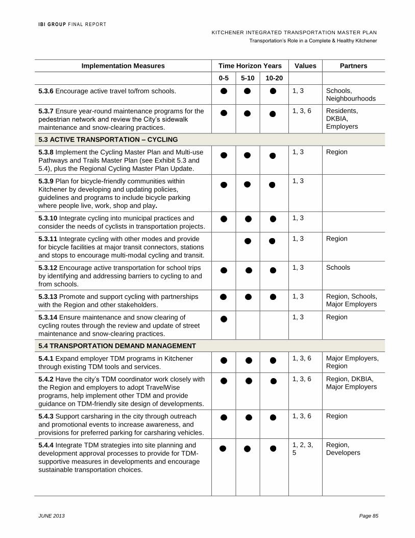
I B I G R O U P F I N A L R E P O R T
KITCHENER INTEGRATED TRANSPORTATION MASTER PLAN
Transportation‟s Role in a Complete & Healthy Kitchener
JUNE 2013 Page 85
Implementation Measures Time Horizon Years Values Partners
0-5 5-10 10-20
5.3.6 Encourage active travel to/from schools. 1, 3 Schools, Neighbourhoods
5.3.7 Ensure year-round maintenance programs for the
pedestrian network and review the City‟s sidewalk
maintenance and snow-clearing practices.
1, 3, 6 Residents, DKBIA, Employers
5.3 ACTIVE TRANSPORTATION – CYCLING
5.3.8 Implement the Cycling Master Plan and Multi-use
Pathways and Trails Master Plan (see Exhibit 5.3 and
5.4), plus the Regional Cycling Master Plan Update.
1, 3 Region
5.3.9 Plan for bicycle-friendly communities within
Kitchener by developing and updating policies,
guidelines and programs to include bicycle parking
where people live, work, shop and play.
1, 3
5.3.10 Integrate cycling into municipal practices and
consider the needs of cyclists in transportation projects.
1, 3
5.3.11 Integrate cycling with other modes and provide
for bicycle facilities at major transit connectors, stations
and stops to encourage multi-modal cycling and transit.
1, 3 Region
5.3.12 Encourage active transportation for school trips
by identifying and addressing barriers to cycling to and
from schools.
1, 3 Schools
5.3.13 Promote and support cycling with partnerships
with the Region and other stakeholders.
1, 3 Region, Schools, Major Employers
5.3.14 Ensure maintenance and snow clearing of
cycling routes through the review and update of street
maintenance and snow-clearing practices.
1, 3 Region
5.4 TRANSPORTATION DEMAND MANAGEMENT
5.4.1 Expand employer TDM programs in Kitchener
through existing TDM tools and services.
1, 3, 6 Major Employers, Region
5.4.2 Have the city‟s TDM coordinator work closely with
the Region and employers to adopt TravelWise
programs, help implement other TDM and provide
guidance on TDM-friendly site design of developments.
1, 3, 6 Region, DKBIA, Major Employers
5.4.3 Support carsharing in the city through outreach
and promotional events to increase awareness, and
provisions for preferred parking for carsharing vehicles.
1, 3, 6 Region
5.4.4 Integrate TDM strategies into site planning and
development approval processes to provide for TDM-
supportive measures in developments and encourage
sustainable transportation choices.
1, 2, 3, 5
Region, Developers

I B I G R O U P F I N A L R E P O R T
KITCHENER INTEGRATED TRANSPORTATION MASTER PLAN
Transportation‟s Role in a Complete & Healthy Kitchener
JUNE 2013 Page 86
Implementation Measures Time Horizon Years Values Partners
0-5 5-10 10-20
5.4.5 Work with Region and local partners to engage
residents through individualized marketing to promote
and encourage sustainable modes of transportation for
all types of trips.
1, 2, 3, 4, 5, 6
Region, Neighbourhoods, Developers, Major Employers
5.5 NEIGHBOURHOOD TRAFFIC MANAGEMENT (TRAFFIC CALMING)
5.5.1 .1 Review and update where required the City‟s
Traffic Calming Policy.
1, 2
5.6 PARKING SUPPLY & MANAGEMENT
5.6.1 Assess and facilitate redevelopment opportunities
of surface parking lots and continue to develop city-
owned parking structures and garages at key locations
to meet demand.
1, 5, 6 DKBIA Developers
5.6.2 Implement parking recommendations from the
City‟s Long-Term Parking Strategy report.
1, 5, 6 DKBIA
5.6.3 Link TDM efforts with economic development to
encourage downtown employees to use alternative
modes of transportation and encourage business to
implement TDM programs for their employees.
1, 5, 6 DKBIA, Major Employers
5.6.4 Coordinate Parking Enterprise and TDM initiatives
together for mutual support and to avoid competition.
1, 3
5.6.5 Consider regional parking policies as outlined in
the Region of Waterloo Parking Management Strategy.
1, 2, 5, 6
Region
5.6.6 Review and update Zoning By-law to include
revised parking standards for both the downtown and
the city as a whole.
1, 5, 6
5.7 GOODS MOVEMENT
5.7.1 Plan for an effective and sustainable goods
movement network in Kitchener.
1, 3
5.7.2 Improve connections and access to provincial
highways and regional arterials as part of a sustainable
goods movement network.
1, 3 Region, MTO
5.7.3 Establish regular communication channels and
continue to work with stakeholders.
2 Goods Movement Providers
5.7.4 Support more sustainable and innovative practices
for local goods movement to reduce impacts on
neighbourhoods and local streets.
1, 3 Goods Movement Providers
5.7.5 Improve efficiency of the goods movement
network through use of intelligent transportation
systems mainly on provincial highways and regional
roads.
1, 3 Region, MTO

I B I G R O U P F I N A L R E P O R T
KITCHENER INTEGRATED TRANSPORTATION MASTER PLAN
Transportation‟s Role in a Complete & Healthy Kitchener
JUNE 2013 Page 87
Implementation Measures Time Horizon Years Values Partners
0-5 5-10 10-20
5.7.6 Work with the Province and Region on higher-level
policies and strategies to improve goods movement
within the realm of land use and transportation planning
1, 3 Region, MTO
5.8 TRAFFIC CONTROL
5.8.1 Maintain existing traffic control warrants. 1 Region
6.3 Performance Measures Framework
Performance measurement is necessary to gauge the effectiveness of the
policies, programs and infrastructure improvements in achieving the City‟s
Transportation Goal and Objectives as defined in Section 1.4, and the 2031
Transportation Vision presented in Section 1.5. The performance measurement
program provides a framework for the City to track changes in land use patterns,
demographic characteristics, system performance and mode choice over time.
This information will allow the City to assess the success of actions taken and
provide guidance in further implementation of the TMP.
The following performance measurement framework is structured according to
the six strategic planning objectives of this TMP. This list represents a desirable
set of indicators for monitoring the implementation of the TMP and resulting
transportation performance. It is recognized that many of these indicators
require additional data collection and analysis, and all may not be achievable
given current data and staffing resources. However, it may also be possible to
pool efforts with the Region of Waterloo to maximize joint benefits.
Performance measurement should be conducted every five years in association
with the recommended TMP review and updating. Furthermore, corridor, area
and intersection-specific monitoring both as recommended in this TMP and on
an as-required basis may be warranted to monitor localized conditions and
needs.
Exhibit 6.2: Proposed Performance Measurement Framework
Strategic Objective Performance Indicators
1. Develop guiding
transportation policies for
subjects ranging from traffic
control through to parking
requirements.
Approve the TMP
Update Traffic Calming Policy
Review Zoning Bylaw parking provisions
2. Provide planning direction
to the year 2031 with short,
medium and long term goals.
Incorporate recommended short and
medium term city road, active
transportation, streetscaping and TDM
investments into the City Capital Forecast
and Growth Management Plan
Number of intersections operating at LOS

I B I G R O U P F I N A L R E P O R T
KITCHENER INTEGRATED TRANSPORTATION MASTER PLAN
Transportation‟s Role in a Complete & Healthy Kitchener
JUNE 2013 Page 88
D or better
Average AM peak period auto trip travel
time (minutes)
AM peak period and all day auto
occupancy
3. Provide transportation
planning direction for
enhanced alternative modes
of transportation (walking,
cycling and transit).
Annual funding for the TDM Plan, Cycling
Master Plan and Multi-use Pathways and
Trails Master Plan recommendations
Support Regional initiatives to improve
conventional transit service and introduce
rapid transit service in Kitchener
4. Develop an integrated
transportation system that
supports Regional bus and
planned rapid transit.
AM peak period and all day transit supply
(seat-km per capita)
Average transit commute time (minutes)
% completion of rapid transit line
5. Develop a city that is less
reliant on cars.
Automobile ownership per capita
AM peak period and all day transit,
bicycle and walking mode shares
6. Support growth
intensification initiatives in a
sustainable manner.
Population density (population per ha)
Employment density (jobs per ha)
Average journey to work trip distance
Report road injuries and fatalities
Reported cycle and pedestrian collisions
Neighbourhood traffic complaints
received
6.4 Funding Requirements
The TMP has identified a number of infrastructure projects, programs and
policies that require funding throughout the life of the plan. The following
sections provide a breakdown of the estimated financial investment to
implement the TMP.
Capital Investment
Exhibit 6.3 summarizes the estimated annual capital costs of transportation
projects and programs (not including resurfacing, reconstruction, maintenance
or related utilities) in the City‟s Capital Budget and those identified in this TMP.
Note: the costs in Exhibit 6.3 do not include road reconstruction projects,
associated utility reconstruction costs, street lighting projects except where part
of a capacity enhancement (i.e. widening) project
Capital expenditures in 2013 are just over $ 5 M. Other than this, the largest
share of these expenditures is for budgeted roadway capacity enhancement
projects (widening, extension), followed by traffic calming projects.

I B I G R O U P F I N A L R E P O R T
KITCHENER INTEGRATED TRANSPORTATION MASTER PLAN
Transportation‟s Role in a Complete & Healthy Kitchener
JUNE 2013 Page 89
The implementation of this TMP will cost in the order of $5.5 M/year to 2017,
then $4.25 M/year to 2022 and then decrease to about $2.7 M/year to 2031.
These cost estimates are capital construction and related studies only, and does
not include system maintenance such as road resurfacing and rehabilitation.
Exhibit 6.3: Estimated Capital Expenditures by Time Horizon Required for Transportation Master Plan Implementation (all figures in thousands, 2013$)
Funding Sources:
GL – General Tax Levy, DC – Development Charges, PE – Parking Enterprise,
OT - Other
($000‟s)
Existing 2013 Capital Expenditures
1
Short Term 2014-2017
Medium Term 2018-2022
Long Term 2023-2031
Source
Amt $000‟s Source
Amt $$000‟s Source
Amt $000‟s Source
Amt $000‟s
EXISTING 2013 CAPITAL BUDGET
Parking Enterprise Capital Costs
2 PE/OT $220 PE/OT $2,375 PE/OT $3,640 PE/OT $7,055
Traffic Calming 3 GL $220 GL $934 GL $1,295 GL $2,475
Transportation Demand Mgmt
4 PE/OT $200 PE/OT $800 PE/OT $1,125 PE/OT $2,160
Active Transportation 5 PE/OT $200 PE/OT $900 PE/OT $1,640 PE/OT $3,150
Street Capacity Enhancement - Budgeted 7:
Strasburg Rd. Extension DC $0 DC $8,500 DC $8,500 $0
Huron Rd. Widening DC $4,300 DC $5,700 $0 $0
Sub-Total By Source PE/OT $620 PE/OT $4,075 PE/OT $6,405 PE/OT $12,365
GL $220 GL $934 GL $1,295 GL $2,475
DC $4,300 DC $14,200 DC $8,500
Sub-Total Horizon Budget $5,140 $19,210 $16,200 $14,840
Average Budgeted Expenditure/Year - $4,800 $3,240 $1,650
PROPOSED NEW CAPITAL FUNDING
Transportation Studies 6 DC $410 DC $420 DC $1,250
Street Capacity Enhancements – New Funding: 8:
Huron Rd. Widening, Fischer-Hallman to Trussler $0 $0 DC $7,000
Strasburg Rd., Widening, Block Line to Bleams $0 GL $3,500
SW Kitchener Collector Streets $0 $0 DC TBD
Block Line Rd., Strasburg to Homer Watson GL $2,500 0$ $0
Wellington St. N/Shirley Ave. Widening $0 GL TBD $0
Strategic Intersection Improvements $0 GL $1,200 GL $1,200
Sub-Total By Source DC $410 DC $420 DC $8,250
GL $2,500 GL $4,700 GL $1,200
Sub-Total Horizon New Capital Funding $2,910 $5,120 $9,450
Average New Capital/Year $730 $1,025 $1,050
TOTAL NEW CAPITAL FUNDING $22,120 $21,320 $24,300
AVERAGE CAPITAL EXPENDITURE/YEAR $5,530 $4,265 $2,700
Notes 1 Expenditures for 2013 from City of Kitchener 10 Year Capital Forecast 2013-2022.
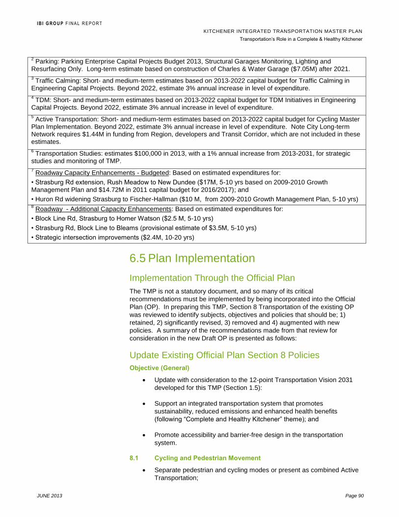
I B I G R O U P F I N A L R E P O R T
KITCHENER INTEGRATED TRANSPORTATION MASTER PLAN
Transportation‟s Role in a Complete & Healthy Kitchener
JUNE 2013 Page 90
2 Parking: Parking Enterprise Capital Projects Budget 2013, Structural Garages Monitoring, Lighting and
Resurfacing Only. Long-term estimate based on construction of Charles & Water Garage ($7.05M) after 2021.
3 Traffic Calming: Short- and medium-term estimates based on 2013-2022 capital budget for Traffic Calming in
Engineering Capital Projects. Beyond 2022, estimate 3% annual increase in level of expenditure.
4 TDM: Short- and medium-term estimates based on 2013-2022 capital budget for TDM Initiatives in Engineering
Capital Projects. Beyond 2022, estimate 3% annual increase in level of expenditure.
5 Active Transportation: Short- and medium-term estimates based on 2013-2022 capital budget for Cycling Master
Plan Implementation. Beyond 2022, estimate 3% annual increase in level of expenditure. Note City Long-term Network requires $1.44M in funding from Region, developers and Transit Corridor, which are not included in these estimates.
6 Transportation Studies: estimates $100,000 in 2013, with a 1% annual increase from 2013-2031, for strategic
studies and monitoring of TMP.
7 Roadway Capacity Enhancements - Budgeted: Based on estimated expenditures for:
• Strasburg Rd extension, Rush Meadow to New Dundee ($17M, 5-10 yrs based on 2009-2010 Growth Management Plan and $14.72M in 2011 capital budget for 2016/2017); and
• Huron Rd widening Strasburg to Fischer-Hallman ($10 M, from 2009-2010 Growth Management Plan, 5-10 yrs) 8 Roadway - Additional Capacity Enhancements: Based on estimated expenditures for:
• Block Line Rd, Strasburg to Homer Watson ($2.5 M, 5-10 yrs)
• Strasburg Rd, Block Line to Bleams (provisional estimate of $3.5M, 5-10 yrs)
• Strategic intersection improvements ($2.4M, 10-20 yrs)
6.5 Plan Implementation
Implementation Through the Official Plan
The TMP is not a statutory document, and so many of its critical
recommendations must be implemented by being incorporated into the Official
Plan (OP). In preparing this TMP, Section 8 Transportation of the existing OP
was reviewed to identify subjects, objectives and policies that should be; 1)
retained, 2) significantly revised, 3) removed and 4) augmented with new
policies. A summary of the recommendations made from that review for
consideration in the new Draft OP is presented as follows:
Update Existing Official Plan Section 8 Policies
Objective (General)
Update with consideration to the 12-point Transportation Vision 2031
developed for this TMP (Section 1.5):
Support an integrated transportation system that promotes
sustainability, reduced emissions and enhanced health benefits
(following “Complete and Healthy Kitchener” theme); and
Promote accessibility and barrier-free design in the transportation
system.
8.1 Cycling and Pedestrian Movement
Separate pedestrian and cycling modes or present as combined Active
Transportation;

I B I G R O U P F I N A L R E P O R T
KITCHENER INTEGRATED TRANSPORTATION MASTER PLAN
Transportation‟s Role in a Complete & Healthy Kitchener
JUNE 2013 Page 91
Objectives / Policies– Retain and augment with Pedestrian objectives
and policies from the TMP and Multi-Use Pathways and Trails Master
Plan, including enhancing the pedestrian environment through
measures such as:
Width of sidewalk;
Conditions for people with disabilities;
Street amenities;
Traffic signal changes;
Weather protection; and
Lighting
Retain and augment with cycling objectives and policies from the
Cycling Master Plan to implement policies and programs that facilitate
and encourage cycling as a viable mode of transportation, such as:
On-street and off-street cycling networks;
Roadway design and maintenance;
Bike facilities in new developments;
Public awareness: convenience, health and economic benefits
of cycling;
Education programs on safety and responsibilities; and,
Integrate cycling and transit.
8.2 Public Transit
Objectives /Policies – Augment with additional objectives and policies
supporting the Region of Waterloo rapid transit planning, operations
and system integration, transit–supportive land use planning and
transit-oriented design.
Refer to the Regional Transportation Master Plan mode share targets
for transit and Grand River Transit service targets (i.e. 95% of
residences, places of work and public facilities, within 450 m of transit
stop);
Locate major trip generators near existing or planned transit routes;
Lay out new arterial and collector roads to promote efficient and direct
transit routes;
Require sidewalks on both sides of streets served by transit;
Include transit service requirements in site planning and subdivision
planning, including transit stop locations;

I B I G R O U P F I N A L R E P O R T
KITCHENER INTEGRATED TRANSPORTATION MASTER PLAN
Transportation‟s Role in a Complete & Healthy Kitchener
JUNE 2013 Page 92
Promote transit in the downtown as an alternative to driving and related
parking demand;
Recognize the planned Multi-Modal Transit Hub; and
Consider the impact of transit service when applying parking standards.
8.3 Road System
Objective/Policies – Change objective to reflect Complete Streets rather
than focus only on vehicular movement on City streets. The objectives
for streets should include all modes of transportation using the public
right-of-way; and
Include new Street Network Classification System (TMP Exhibit 5.2)
either with reference to or integration with the Multi-use Pathways and
Trails Master Plan and Cycling Master Plan.
8.3.1 General Policies
Incorporate the new street classifications using the Street Network
Classification System from TMP section 5.1; and
Update and augment Items #2 - #9 involving specific land
use/transportation considerations.
8.3.2 Specific Roads
The specific road access policies in Section 8.3.2 of the current Official Plan,
namely those for King Street East in the Pioneer Tower East and West area and
in the Fairway Road/Wilson Avenue area, are overly specific for OP policies and
should be dealt with at the location-specific planning approval stage.
8.3.3 Scenic–Heritage Roads (Heritage Corridors)
This sub-section of the OP transportation section should be maintained and
updated including addition of criteria to be used in designating Scenic-Heritage
Roads, and their designation as a road classification overlay rather than a
distinct class as described in TMP Section 5.1.
8.3.4 Regional Transportation Systems
Update this section to reflect Regional Road recommendations from the
Regional TMP for road widening, new roads, access management improvement,
intersection improvement and transit priority projects.
8.4 Road Widenings
Update using a minimum 18.0 m for streets (not including lanes) as included in
the TMP Street Network Classification System.
8.5 Parking
Include opportunities for parking reductions in both the Downtown and
throughout the City;
Consider adding policies that provide more detail on supporting transit
and Active Transportation including examples (i.e. limit surface parking,

I B I G R O U P F I N A L R E P O R T
KITCHENER INTEGRATED TRANSPORTATION MASTER PLAN
Transportation‟s Role in a Complete & Healthy Kitchener
JUNE 2013 Page 93
parking pricing, provision for carpool/shared parking, bicycle parking
and other cycling facilities);
Include a policy on use of cash-in-lieu of parking and
Reference parking requirements in the Zoning By-law, and with more
emphasis on how parking is part of the integrated transportation system
(e.g. encourage sustainable modes of travel through parking supply and
parking pricing).
Implementation Through the Official Plan – New Policies
In addition to the recommended policy updates for the new Draft OP, this TMP
has also identifies the following additional transportation policies that should be
included in the new Draft OP and that are not addressed in the existing OP:
General
Emphasis on health benefits, social interaction and economic
development for both cycling and walking as a transportation mode, plus
environmental benefits of transit;
Integration of transit with other modes including park-and-ride, multi-use
pathways and trails, cycling and commuter rail (GO Transit);
Integration of the land use and transportation planning processes.
Role of partners in City of Kitchener transportation planning including
the Region, Grand River Transit, Ministry of Transportation and
Metrolinx (GO Transit);.
Goods Movement
Policy statement on safe and efficient movement of goods as part of an
integrated transportation network;
Add policy direction that supports a sustainable goods movement
network with key corridors, potential opportunities to improve efficiency
and improved Highway 401 access when required, plus a strategic
goods movement network that discourage truck traffic in certain areas or
corridors;
Transportation Demand Management (TDM)
Include a new OP policy or policies that support the use of TDM in the City of
Kitchener, with specific reference to TDM measures and recommendations of
the City‟s TDM Plan.
Funding and Implementation
Include a policy or policies that describe the City‟s approach to transportation
system funding including access to capital funding opportunities at the local,
regional, provincial and federal levels.
The TMP can also include specific recommendations with regards to
maintenance of the transportation system, including directing priorities to transit
and Active Transportation corridors, discourage deferred maintenance of
I B I G R O U P F I N A L R E P O R T
KITCHENER INTEGRATED TRANSPORTATION MASTER PLAN
Transportation‟s Role in a Complete & Healthy Kitchener
JUNE 2013 Page 94
important transportation system elements such as sidewalks and coordinate
preventive and planned maintenance of the City‟s transportation system for
maximum benefits. Maintenance-related policies could also include support for
the use of sustainable practices in the maintenance of streets, pathways and
trails and parking areas/facilities including the selection of materials and
equipment.
Official Plan Schedule – Street Right-of-Way Widening
Schedule D of the current Kitchener Official Plan presents a list of city streets
and their ultimate road right-of-way width. The narrowest public streets are
lanes with a 7.62 m width, and this should not be changed since these lanes are
provided for rear property access only, and do not require sidewalks and
boulevard spaces.
There are other narrow streets listed on Schedule D with an ultimate 16 m right-
of-way width, and it is recommended that this be amended in the revised Official
Plan to a minimum 18 m as per the Transportation Network Classification
System presented on Exhibit 5.1 of this TMP. All local streets in Kitchener
should therefore be planned to have a minimum 18 m right-of-way width in order
to accommodate sidewalks and shared cycling routes where appropriate.
Where this ultimate minimum width is not available, it should be provided
through any redevelopment process.
Implementation Through the Development Approval Process
Many of the TDM and sustainable transportation objectives and measures
included in this TMP may be implemented through the rezoning, plan of
subdivision and official plan amendment process, and to a lesser degree
through the application process for site plan approval.
Applications for Official Plan Amendment, Rezoning or Plan of Subdivision
These types of development applications usually represent the best way for a
municipality to influence development because the municipality can require or
negotiate sustainable transportation-related features. The City of Kitchener has
approval authority for rezoning and plan of subdivision applications, so can
include conditions in rezoning and plan of subdivision approvals that support
sustainable transportation, Complete Streets, TDM and Active Transportation.
For Official Plan amendments, the Region is the approval authority and so can
potentially include similar approval conditions that reflect their own sustainable
transportation policies and those of the City of Kitchener.
One important limitation to using these types of planning applications to
implement sustainable transportation measures occurs when the applicant for
an Official Plan amendment or rezoning is not the same as the future applicant
for site plan approval. In these cases, it is difficult to guarantee that TDM
measures such as reduced parking, flex hours and carpooling will actually be
implemented if the development applicant is not the eventual end user (i.e. the
develop or builder).
In order to effectively implement the sustainable transportation measures in this
TMP, the Kitchener Official Plan should include policies supporting the provision

I B I G R O U P F I N A L R E P O R T
KITCHENER INTEGRATED TRANSPORTATION MASTER PLAN
Transportation‟s Role in a Complete & Healthy Kitchener
JUNE 2013 Page 95
of these measures as part of the rezoning and plan of subdivision application
processes focusing on:
Off-Street Parking including reduction opportunities;
Site Access and Circulation;
Transit-Supportive Planning and Transit-Oriented Design;
Cycling and Walking Supportive Measures; and
Trip Reduction Measures.
Applications for Site Plan Approval
The City of Kitchener, as the approval authority, can control and encourage
many aspects of sustainable transportation including TDM, parking supply
(minimum vs. maximum requirements) and the “Complete Streets” approach in
what it requires in approving applications for site plan approval. However, if a
site plan application complies with the Zoning Bylaw, the municipality has less
leverage to require changes, or to pass for example a TDM checklist if the
application conforms to the Bylaw. Therefore, it is very important in the site plan
approval process that Zoning Bylaw provisions also support certain sustainable
transportation objectives, for example in the provision of parking and
requirements for bicycle parking and preferred parking for car-share and
alternative fuel vehicles.
Also, implementation of transportation objectives at the site plan level is limited
to building exteriors, and cannot affect interiors unless, once again, regulations
are incorporated into the Zoning Bylaw. Finally, many of the “soft” program-
related recommendations of this TMP, for example involving certain TDM
initiatives such as carpooling, are not enforceable through the Planning Act.
In conclusion, the City of Kitchener should add more sustainable transportation,
TDM and Complete Streets policies into the Official Plan, Zoning Bylaw and
Development Manual to ensure there is clarity regarding what the City requires
in terms of transportation and circulation features as part of development
applications.