Embed Size (px)
Citation preview

Ecological Impact Assessment
for ‘Phase 3 Earls Court’, Kill Hill, Kill, Co. Kildare
FINAL REPORT
20th December 2017
Faith Wilson Ecological Consultant B.Sc. (Hons) CEnv MCIEEM Kestrel Ridge, Tigroney West, Avoca, Co. Wicklow

Faith Wilson Ecological Consultant CEnv BSc MCIEEM
2
Ecological Impact Assessment
for ‘Phase 3 Earls Court’, Kill Hill, Kill, Co. Kildare
Table of Contents 1. INTRODUCTION ................................................................................................................. 3
1.1 Background ............................................................................................................. 3 1.2 Relevant Legislation ............................................................................................... 4
1.2.1 Nature Conservation Designations .............................................................. 4 1.2.2 Bats .................................................................................................................... 5 1.2.3 Badgers ............................................................................................................. 6 1.2.4 Invasive Species .............................................................................................. 7 1.2.5 Fisheries ......................................................................................................... 12
1.3 Survey Constraints ............................................................................................... 12 2. METHODOLOGY .............................................................................................................. 13
2.1 Project Description ............................................................................................... 13 2.2 Desk Study ............................................................................................................. 13 2.3 Field Surveys ......................................................................................................... 14
3. RESULTS .............................................................................................................................. 16 3.1 Field Surveys ......................................................................................................... 16
4. ASSESSMENT OF SIGNIFICANCE ................................................................................. 23 5. ECOLOGICAL IMPACT ASSESSMENT ........................................................................ 23
5.1 Potential Impacts .................................................................................................. 23 5.1.1 Construction Phase: ...................................................................................... 24 5.1.2 Operational Phase: ........................................................................................ 27
6. PROPOSED MITIGATION MEASURES ......................................................................... 27 6.1 Sediment Control .................................................................................................. 27 6.2 Contractor Briefing ............................................................................................... 28 6.3 Avoidance/Protection Measures for Retained Vegetation and Trees .......... 29 6.4 Protection Measures for Birds ............................................................................. 29 6.5 Protection Measures for Bats .............................................................................. 29 6.6 Protection Measures for Badgers ........................................................................ 30 6.7 Soil Handling ........................................................................................................ 30 6.8 Landscaping .......................................................................................................... 31 6.9 Lighting .................................................................................................................. 31 6.10 Flora ........................................................................................................................ 33
7. CONCLUSIONS ................................................................................................................. 33 8. REFERENCES ..................................................................................................................... 34

Faith Wilson Ecological Consultant CEnv BSc MCIEEM
3
Ecological Impact Assessment
for ‘Phase 3 Earls Court’, Kill Hill, Kill, Co. Kildare
1. INTRODUCTION
1.1 Background This report has been prepared by Faith Wilson (an independent ecological consultant and licensed bat specialist) who was appointed by JFOC Architects (on behalf of McCourt Investments Limited) to prepare an ecological impact assessment report for planning permission for a proposed housing development (Phase 3 of Earl’s Court) at Kill Hill, Kill, Co. Kildare as shown on Figure 1.1 below.
Figure 1.1 Site location adjoining Earl’s Court lands at Kill Hill, Kill, Co. Kildare. Pre planning meetings with the local authority (Kildare County Council) and An Bord Pleanála recommended that:
‘the impact of the removal of the hedgerow traversing the site needs to be the subject of further assessment. An ecological impact assessment is required’.
This report, coupled with the arboricultural impact assessment fulfils that requirement.

Faith Wilson Ecological Consultant CEnv BSc MCIEEM
4
1.2 Relevant Legislation
1.2.1 Nature Conservation Designations International Conservation Designations The lands proposed for the development of housing at Kill Hill (henceforth referred to as the site) are not currently designated for any nature conservation purposes under international conservation legislation. There are nine Natura 2000 designated sites within a 15km radius of the site. These are as follows:
• Ballynafagh Bog SAC (Site Code: 000391) • Ballynafagh Lake SAC (Site Code: 001387) • Glenasmole Valley SAC (Site Code: 001209) • Red Bog, Kildare SAC (Site Code: 000397) • Mouds Bog SAC (Site Code: 002331) • Rye Water Valley/Carton SAC (Site Code: 001398) • Wicklow Mountains SAC (Site Code: 002122) • Wicklow Mountains SPA (Site Code: 004040) • Poulaphouca Reservoir SPA (Site Code: 004063)
Special Areas of Conservation (SACs) are habitats of international significance that have been identified by NPWS and submitted for designation to the EU. SAC is a statutory designation, which has a legal basis under the EU Habitats Directive (92/43/EEC) as transposed into Irish law through the European Communities (Natural Habitats) Regulations, 1997, which were amended in 1998, 2005 and 2011. The European Communities (Birds and Natural Habitats) Regulations 2011 consolidate the European Communities (Natural Habitats) Regulations 1997 to 2005 and the European Communities (Birds and Natural Habitats)(Control of Recreational Activities) Regulations 2010, as well as addressing transposition failures identified in the Court of Justice of the European Union (CJEU) judgements. A Special Protection Area (SPA) is a statutory designation, which has a legal basis under the EU Birds Directive (79/409/EEC). The primary objective of SPAs is to maintain or enhance the favourable conservation status of the birds for which the SPAs have been designated. National Conservation Designations Proposed NHAs are habitats or sites of interest to wildlife that have been identified by NPWS. These sites become NHAs once they have been formally advertised and land owners have been notified of their designation. NHAs are protected under the Wildlife (Amendment) Act, 2000, from the date they are formally proposed. NHA is a statutory designation according to the Wildlife (Amended) Act, 2000 and requires consultation with NPWS if any development impacts on a pNHA. All of the Natura 2000 sites listed above (with the exception of the Wicklow Mountains SAC/SPA) are also designated as pNHAs. There are 16 pNHAs in total within a 15km radius of the lands at Kill Hill. The other pNHAs include:

Faith Wilson Ecological Consultant CEnv BSc MCIEEM
5
• Dondaea Wood pNHA (Site Code: 001391) • Grand Canal pNHA (Site Code: 002104) • Kilteel Wood pNHA (Site Code: 001394) • Liffey at Osberstown pNHA (Site Code: 001395) • Liffey Valley pNHA (Site Code: 000128) • Liffey Valley Meander Belt pNHA (Site Code: 000393) • Lugmore Glen pNHA (Site Code: 001212) • Royal Canal pNHA (Site Code: 002103) • Slade of Saggart and Crooksling Glen pNHA (Site Code: 000211)
NHAs are considered to be of national importance, while SACs and SPAs are of international importance for nature conservation. The lands proposed for development at Kill Hill are not currently designated for any nature conservation purposes under national conservation legislation. A report for Screening for Appropriate Assessment (Simon Clear & Associates, 2017) to assess any potential impacts of the proposed development on any Natura 2000 sites has been completed for the project.
1.2.2 Bats Eleven species of bats occur in Ireland and all are protected under both national and international law. Wildlife Act 1976 In the Republic, under Schedule 5 of the Wildlife Act 1976, all bats and their roosts are protected by law. It is unlawful to disturb either without the appropriate licence. The Act was amended in 2000. Bern and Bonn Convention Ireland has also ratified two international conventions, which afford protection to bats amongst other fauna. These are known as the ‘Bern’ and ‘Bonn’ Conventions. The Convention on the Conservation of European Wildlife and Natural Habitats (Bern Convention 1982), exists to conserve all species and their habitats, including bats. The Convention on the Conservation of Migratory Species of Wild Animals (Bonn Convention 1979, enacted 1983) was instigated to protect migrant species across all European boundaries, which covers certain species of bat. EU Habitats Directive All bat species are given strict protection under Annex IV of the EU Habitats Directive, whilst the lesser horseshoe bat (Rhinolophus hipposideros) and greater horseshoe bat (Rhinolophus ferrumequinum) are given further protection under Annex II of the EU Habitats Directive. Both are listed as a species of community interest that is in need of strict protection and for which E.U. nations must designate Special Areas of Conservation (SACs). The latter is only known from a single site and no breeding populations have been recorded to date. The former are a species of the western seaboard of Ireland and have not yet been recorded on the east coast.

Faith Wilson Ecological Consultant CEnv BSc MCIEEM
6
The principal pressures on Irish bat species have been identified as follows:
• urbanized areas (e.g. light pollution); • bridge/viaduct repairs; • pesticides usage; • removal of hedges, scrub, forestry; • water pollution; • other pollution and human impacts (e.g. renovation of
dwellings with roosts); • infillings of ditches, dykes, ponds, pools and marshes; • management of aquatic and bank vegetation for drainage
purposes; • abandonment of pastoral systems; • speleology and vandalism; • communication routes: roads; and • inappropriate forestry management.
1.2.3 Badgers Badgers (Meles meles) are common and widespread in Ireland, and are found in all lowland habitats where the soil is dry and not subject to flooding (Hayden and Harrington, 2000). Badgers are social animals that live in complex underground tunnel systems called setts. Badger territories may vary in size from about 60-200 ha (Smal, 1995). Badgers and their setts legally are protected under the provisions of the Wildlife Act, 1976, and the Wildlife Amendment Act, 2000. It is an offence to intentionally kill or injure a protected species or to wilfully interfere with or destroy the breeding site or resting place of a protected wild animal. It is standard best practice to ensure that mitigation measures are taken to limit impacts on badgers and badger populations during developments. The removal of badgers from affected setts and subsequent destruction of these setts must be conducted under licence by experienced badger experts or other suitably qualified personnel. The National Parks and Wildlife Service (NPWS) of the Department of the Environment, Heritage and Local Government grant licences to the experts undertaking the badger operations and not to the developer or contractor. An application for a wildlife licence should be submitted to the NPWS with the relevant ecological information from the detailed badger survey. At least three weeks is normally required to process a licence application, but early discussions with NPWS can expedite the procedure. Conditions are usually attached to each wildlife licence granted in respect of badgers. It is normal practice to impose seasonal constraints e.g. that breeding setts are not interfered with or disturbed during the badger breeding season (December to June inclusive). No active sett should be interfered with or disturbed during the breeding season as any sett category may contain cubs. Closure of setts during the breeding season requires monitoring to demonstrate no sett activity occurs.
Faith Wilson Ecological Consultant CEnv BSc MCIEEM
7
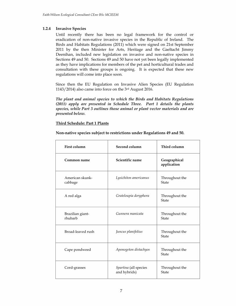
1.2.4 Invasive Species Until recently there has been no legal framework for the control or eradication of non-native invasive species in the Republic of Ireland. The Birds and Habitats Regulations (2011) which were signed on 21st September 2011 by the then Minister for Arts, Heritage and the Gaeltacht Jimmy Deenihan, included new legislation on invasive and non-native species in Sections 49 and 50. Sections 49 and 50 have not yet been legally implemented as they have implications for members of the pet and horticultural trades and consultation with these groups is ongoing. It is expected that these new regulations will come into place soon. Since then the EU Regulation on Invasive Alien Species (EU Regulation 1143/2014) also came into force on the 3rd August 2016. The plant and animal species to which the Birds and Habitats Regulations (2011) apply are presented in Schedule Three. Part 1 details the plants species, while Part 3 outlines those animal or plant vector materials and are presented below. Third Schedule: Part 1 Plants Non-native species subject to restrictions under Regulations 49 and 50.
First column Second column Third column
Common name Scientific name Geographical application
American skunk-cabbage
Lysichiton americanus Throughout the State
A red alga Grateloupia doryphora Throughout the State
Brazilian giant-rhubarb
Gunnera manicata Throughout the State
Broad-leaved rush Juncus planifolius Throughout the State
Cape pondweed Aponogeton distachyos Throughout the State
Cord-grasses Spartina (all species and hybrids)
Throughout the State

Faith Wilson Ecological Consultant CEnv BSc MCIEEM
8
First column Second column Third column
Common name Scientific name Geographical application
Curly waterweed Lagarosiphon major Throughout the State
Dwarf eel-grass Zostera japonica Throughout the State
Fanwort Cabomba caroliniana Throughout the State
Floating pennywort Hydrocotyle ranunculoides
Throughout the State
Fringed water-lily Nymphoides peltata Throughout the State
Giant hogweed Heracleum mantegazzianum
Throughout the State
Giant knotweed Fallopia sachalinensis Throughout the State
Giant-rhubarb Gunnera tinctoria Throughout the State
Giant salvinia Salvinia molesta Throughout the State
Himalayan balsam Impatiens glandulifera Throughout the State
Himalayan knotweed Persicaria wallichii Throughout the State
Hottentot-fig Carpobrotus edulis Throughout the State

Faith Wilson Ecological Consultant CEnv BSc MCIEEM
9
First column Second column Third column
Common name Scientific name Geographical application
Japanese knotweed Fallopia japonica Throughout the State
Large-flowered waterweed
Egeria densa Throughout the State
Mile-a-minute weed Persicaria perfoliata Throughout the State
New Zealand pigmyweed
Crassula helmsii Throughout the State
Parrot’s feather Myriophyllum aquaticum
Throughout the State
Rhododendron Rhododendron ponticum
Throughout the State
Salmonberry Rubus spectabilis Throughout the State
Sea-buckthorn Hippophae rhamnoides Throughout the State
Spanish bluebell Hyacinthoides hispanica
Throughout the State
Three-cornered leek Allium triquetrum Throughout the State
Wakame Undaria pinnatifida Throughout the State
Water chestnut Trapa natans Throughout the State

Faith Wilson Ecological Consultant CEnv BSc MCIEEM
10
First column Second column Third column
Common name Scientific name Geographical application
Water fern Azolla filiculoides Throughout the State
Water lettuce Pistia stratiotes Throughout the State
Water-primrose Ludwigia (all species) Throughout the State
Waterweeds Elodea (all species) Throughout the State
Wireweed Sargassum muticum Throughout the State
EU Regulation 1143/2014 on Invasive Alien Species
On 14 July 2016 the European Commission published Commission Implementing Regulation 2016/1141 which sets out an initial list of 37 species to which EU Invasive Alien Species Regulation 1143/2014 will apply. The associated restrictions and obligations came into force on 3rd August 2016.
Three distinct types of measures are envisaged under the Directive, which follow an internationally agreed hierarchical approach to combatting IAS:
Prevention: a number of robust measures aimed at preventing IAS of Union concern from entering the EU, either intentionally or unintentionally.
Early detection and rapid eradication: Member States must put in place a surveillance system to detect the presence of IAS of Union concern as early as possible and take rapid eradication measures to prevent them from establishing.
Management: some IAS of Union concern are already well-established in certain Member States and concerted management action is needed so that they do not spread any further and to minimize the harm they cause.
Plant species listed on the directive include:
American skunk cabbage Lysichiton americanus Asiatic tearthumb Persicaria perfoliata (Polygonum perfoliatum) Curly waterweed Lagarosiphon major

Faith Wilson Ecological Consultant CEnv BSc MCIEEM
11
Eastern Baccharis Baccharis halimifolia Floating pennywort Hydrocotyle ranunculoides Floating primrose willow Ludwigia peploides Green cabomba Cabomba caroliniana Kudzu vine Pueraria lobata Parrot's feather Myriophyllum aquaticum Persian hogweed Heracleum persicum Sosnowski's hogweed Heracleum sosnowskyi Water hyacinth Eichhornia crassipes Water primrose Ludwigia grandiflora Whitetop weed Parthenium hysterophorus
Animal species listed on the directive include:
Amur sleeper Perccottus glenii Asian hornet Vespa velutina Chinese mitten crab Eriocheir sinensis Coypu Myocastor coypus Fox squirrel Sciurus niger Grey squirrel Sciurus carolinensis Indian house crow Corvus splendens Marbled crayfish Procambarus spp. Muntjac deer Muntiacus reevesii North american bullfrog Lithobates (Rana) catesbeianus Pallas's squirrel Callosciurus erythraeus Raccoon Procyon lotor Red swamp crayfish Procambarus clarkii Red-eared terrapin/slider Trachemys scripta elegans Ruddy duck Oxyura jamaicensis Sacred ibis Threskiornis aethiopicus Siberian chipmunk Tamias sibiricus Signal crayfish Pacifastacus leniusculus Small Asian mongoose Herpestes javanicus South American coati Nasua nasua Spiny-cheek crayfish Orconectes limosus Topmouth gudgeon Pseudorasbora parva Virile crayfish Orconectes virilis
On 13 July 2017 the European Commission published Commission Implementing Regulation 2017/1263 which added a further 12 species to the current list of 37 species regulated under the EU Invasive Alien Species Regulation (1143/2014). These are:
Plant species
Alligator weed (Alternanthera philoxeroides) Milkweed (Asclepias syriaca) Nuttall’s waterweed (Elodea nuttallii) Chilean rhubarb (Gunnera tinctoria) Giant hogweed (Heracleum mantegazzianum) Himalayan balsam (Impatiens glandulifera) Japanese stiltgrass (Microstegium vimineum) Broadleaf watermilfoil (Myriophyllum heterophyllum)

Faith Wilson Ecological Consultant CEnv BSc MCIEEM
12
Crimson fountaingrass (Pennisetum setaceum) Animal species
Egyptian goose (Alopochen aegyptiacus) Raccoon dog (Nyctereutes procyonoides) Muskrat (Ondatra zibethicus)
The associated restrictions and obligations will come into force from 2 August 2017 for all these species apart from the Raccoon dog, where they will not come into force until 2 February 2019. Other Invasive Species The main guidance document that has been prepared dealing with invasive species/noxious weeds on sites is the NRA ‘Guidelines on The Management of Noxious Weeds and Non-Native Invasive Plant Species on National Roads’ which was published in 2010. This document details other non-native species of note. A detailed survey for such species was conducted.
1.2.5 Fisheries According to the EPA Envision Map Viewer the proposed development site is located within the Liffey and Dublin Bay catchment within hydrometric area 09. The lands at Kill Hill drain to the Painestown River, which lies to the south of the proposed development site. The Painestown River enters the River Liffey in Straffan Village. The water quality of the Painestown River is measured as Q3-4 at the bridge within Kill village. It is described as a waterbody at risk of not achieving ‘good water status’ under the Water Framework Directive.
1.3 Survey Constraints
The site surveys were conducted just outside the optimum time for conducting badger and other large mammal surveys, which is December–March (as the likelihood of detecting both setts and signs of badger/large mammal activity increases during the winter months as vegetation cover decreases). It was not possible to conduct a bat activity survey of the site as bats are currently in hibernation. The habitat assessment and botanical surveys were also completed outside the flowering period for plants. The breeding bird season was also finished.

Faith Wilson Ecological Consultant CEnv BSc MCIEEM
13
2. METHODOLOGY
2.1 Project Description It is proposed to develop a housing scheme on the lands at Kill Hill as shown on Figure 2.1 and described below.
Figure 2.1 Proposed site layout at Kill Hill, Kill, Co. Kildare. Planning permission is sought for the construction of a residential development of 130 no. dwellings, 2 no. vehicular connections to The Avenue, Earl’s Court and a further pedestrian link at No. 16 The Green, Earl’s Court and all associated and ancillary site development works.
2.2 Desk Study A desk study was carried out to collate the available information on the ecological environment potentially impacted by the proposed development. The National Parks and Wildlife Service (NPWS) of the Department of Culture, Heritage and the Gaeltacht (DCHG) database of designated conservation areas and NPWS records of rare and protected plant species were checked with regard to the location of the proposed development. Information on protected species of fauna and flora listed for protection under Annex II of the EU Habitats Directive (92/43/EEC), Annex I of the Birds Directive (79/409/EEC) and the Wildlife (Amendment) Act (2000) was also sought from NPWS and published sources. Recent, high resolution, colour aerial photographs were also used to identify and map potential habitats.

Faith Wilson Ecological Consultant CEnv BSc MCIEEM
14
2.3 Field Surveys The site was visited on the 14th November 2017 when the receiving habitats were surveyed and a bird and mammal survey was completed. Habitat & Botanical Survey The habitats present were recorded and described to level 3 (Fossitt, 2000) and a check was made for the presence of any invasive species as described above. Mammal Surveys Bat Survey The bat survey consisted of two elements – a desktop review and consultation with Bat Conservation Ireland and an inspection of trees within the site for their potential to support roosting bats. It was not possible to conduct a bat activity survey of the affected lands as bats are currently in hibernation. The bat surveys were carried out by Faith Wilson, a licensed bat specialist. The aim of the survey was to determine the potential use of any mature trees in the site as roosting sites and based on the desktop research coupled with the habitats present on site identify what species are likely to occur. There are no built structures in which bats might roost affected by the proposed development. Trees impacted by the development were assessed for their potential use by bats using the following standard criteria, which were created by bat specialists from Bat Conservation Ireland for use in the assessments of tree roosts on large infrastructural projects and are summarised in NRA (2006):
• Presence or absence of bat droppings (these can be hard to find amongst leaf litter or may be washed away following periods of wet weather),
• Bat droppings may also be seen as a black streak beneath holes, cracks, branches, etc.,
• Presence or absence of smooth edges with dark marks at potential entrances to roosts,
• Presence or absence of urine stains at potential entrances to roosts,
• Presence of natural cracks and rot holes in the trunk or boughs of the tree,
• Hollow trees, • Presence or absence of creepers such as ivy or honeysuckle on
trees (ivy clad trees are often used by bat species such as pipistrelles as roosts),
• Presence or absence of loose bark such as that of sycamore, or flaky bark on coniferous species such as cedars, cypress and Scot's pine,
• Presence or absence of bracket fungi which may indicate a rotten or potentially hollow centre to the tree,
• Known bat roosts previously identified, • Trees with storm or machinery damage or broken boughs,

Faith Wilson Ecological Consultant CEnv BSc MCIEEM
15
• Clutter level - where the branches and trunk are easily accessible, this is considered a better tree for bat roosts,
• Adjoining habitat - if there are a variety of feeding opportunities for bats, this increases the potential of a tree as a bat roost,
• Adjoining potential roosts / known roosts. This raises the likelihood of a tree being of benefit as bats may move roosts if the roost becomes too hot or cold during roosting and a nearby alternative roost is highly desirable.
The tree survey completed by Felim Sheridan (Arborist Associates, 2017) was also reviewed from the perspective of roosting bats. Badger Survey A badger survey was conducted in the general environs of the site by searching for signs of badger activity. These include setts, old bedding material, feeding signs, latrines, badger tracks or paw prints, badger paths and badger hair caught on vegetation or fences. The survey was carried out by Faith Wilson, an experienced mammal specialist, in accordance with best practice as described in the ‘Ecological Surveying Techniques for Protected Flora and Fauna during the Planning of National Road Schemes’ (NRA 2009) and ‘Guidelines for the treatment of badgers prior to the construction of National Road Schemes’ (NRA 2005). Breeding Birds The breeding bird season was complete and wintering birds were recorded during the course of the site visit.

Faith Wilson Ecological Consultant CEnv BSc MCIEEM
16
3. RESULTS
3.1 Field Surveys The lands at Kill Hill proposed for development consist of three fields of improved agricultural grassland (GA1). The lands to the west of the proposed site consist of the existing Earl’s Court housing development with a school to the north west of the site. The hill of Kill Hill is found to the east of the property and is cloaked in areas of dense gorse scrub (WS1), while further agricultural lands are found to the south. The northern boundary of the site consists of a hedgerow adjoining a local road. The school is bounded by a palisade fence. A habitat map of the property showing the habitats mapped to Fossitt level 3 is presented on Figure 3.1 below. None of the habitats present correspond to any habitat type listed under Annex I of the EU Habitats Directive.
Plate 1. The fields impacted by the development are dominated by improved agricultural grassland. The site is bounded by hedgerows (WL1) and treelines (WL2). Hedgerows also form the internal boundaries between the three fields that make up the site. These hedgerows are dominated by hawthorn (Crataegus monogyna), elder (Sambucus nigra) and blackthorn (Prunus spinosa) with some spindle (Euonymus europaeus), holly (Ilex aquifolium), privet (Ligustrum vulgare), goat willow (Salix caprea), mountain ash (Sorbus aucuparia), gorse (Ulex europaeus), bramble (Rubus fruticosus agg.) and dog rose (Rosa canina). Many of these hedgerows are formed on earthen banks (BL2) and have drainage ditches (FW4) associated with them. In some areas these hedgerows are unmanaged and have begun to spread into the adjoining field. There are occasional mature and semi-mature ash (Fraxinus excelsior), sycamore (Acer pseudoplatanus), beech (Fagus sylvatica), lime (Tilia sp.) and oak (Quercus robur)

Faith Wilson Ecological Consultant CEnv BSc MCIEEM
17
present in the hedgerows, occasionally forming small lengths of treelines (WL2).
Figure 3.1 Habitat map of the lands at Kill Hill. Vegetation at the base of the hedgerows included; creeping buttercup (Ranunculus repens), creeping thistle (Cirsium repens), cow parsley (Anthriscus sylvestris), docks (Rumex sp.), ivy (Hedera helix), cleavers (Galium aparine), groundsel (Senecio vulgaris), ragwort (Senecio jacobaea), male fern (Dryopteris filix-mas), alexanders (Smyrnium olusatrum), nettle (Urtica dioica), germander speedwell (Veronica chamaedrys), bush vetch (Vicia sepium), dandelion

Faith Wilson Ecological Consultant CEnv BSc MCIEEM
18
(Taraxacum agg.), nettles (Urtica dioica), ground ivy (Glechoma hederacea), wood avens (Geum urbanum), hart’s tongue fen (Phyllitis scolopendrium), false oat grass (Arrhenatherum elatius) and cock’s-foot grass (Dactylis glomerata). A small area of habitat, described as recolonising bare ground (ED3) is found on disturbed ground adjacent to the existing housing development. This area was more species diverse than the other parts of the site as it had developed on subsoils from which the majority of the topsoil had been removed. This gives an indication of the floral diversity (calcareous grassland) that would have been present on these lands before agricultural improvement and fertilisation. Species recorded here include; sweet vernal grass (Anthoxanthum odoratum), red fescue (Festuca rubra), creeping bent grass (Agrostis stolonifera), common centaury (Centaurium erythraea), white clover (Trifolium repens), dandelion (Taraxacum agg.), glaucous sedge (Carex flacca), common sedge (Carex nigra), coltsfoot (Tussilago farfara), bramble (Rubus fruticosus agg.), creeping cinquefoil (Potentilla reptans), bird’s foot trefoil (Lotus corniculatus), ribwort plantain (Plantago lanceolata), scattered grey willow (Salix cinerea), soft rush (Juncus effusus), daisy (Bellis perennis), fairy flax (Linum catharticum), docks (Rumex sp.), dog rose (Rosa canina), selfheal (Prunella vulgaris), common chickweed (Stellaria media), dove's-foot crane's-bill (Geranium molle), broad-leaved willowherb (Epilobium montanum), greater plantain (Plantago major), yellow-wort (Blackstonia perfoliata), spear thistle (Cirsium vulgare) and wood false brome (Brachypodium sylvaticum). It is possible that species such as orchids could be found here during the growing season.
Plate 2. Area of recolonised bare ground (ED3) in the south western corner of the site. A strip of grassland at the rear of the existing housing in Earl’s Court has been left unmanaged and has developed as dry grassy verge vegetation (GS2). This is dominated by creeping bent (Agrostis stolonifera), great willowherb (Epilobium hirsutum), nettle (Urtica dioica), creeping thistle (Cirsium repens), self-sown oak (Quercus sp.) and ash (Fraxinus excelsior)

Faith Wilson Ecological Consultant CEnv BSc MCIEEM
19
saplings. Stockpiled topsoil and a number of shipping containers are stored in this area.
Plate 3. Area of dry grassy verge vegetation (GS2) at the rear of the existing housing.
Plate 4. The internal hedgerow in the centre of the site. Drainage ditches (FW4) were present at the base of some of the field’s boundaries on the site and were dry at the time of survey. They did not support any significant vegetation beyond weedy species. Rare, Threatened, and Protected Flora There are historic records of red hemp nettle (Galeopsis angustifolia) and opposite leaved pondweed (Groenlandia densa) from the 10km square in which the development is proposed (N92). There is no suitable habitat for either of these species on the site.
Faith Wilson Ecological Consultant CEnv BSc MCIEEM
20
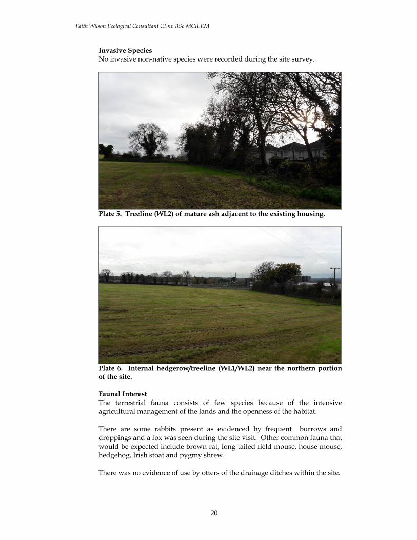
Invasive Species No invasive non-native species were recorded during the site survey.
Plate 5. Treeline (WL2) of mature ash adjacent to the existing housing.
Plate 6. Internal hedgerow/treeline (WL1/WL2) near the northern portion of the site. Faunal Interest The terrestrial fauna consists of few species because of the intensive agricultural management of the lands and the openness of the habitat. There are some rabbits present as evidenced by frequent burrows and droppings and a fox was seen during the site visit. Other common fauna that would be expected include brown rat, long tailed field mouse, house mouse, hedgehog, Irish stoat and pygmy shrew. There was no evidence of use by otters of the drainage ditches within the site.

Faith Wilson Ecological Consultant CEnv BSc MCIEEM
21
It is likely that badgers occur in the vicinity of the site in the scrub on the adjoining Kill Hill – there was evidence of their foraging activity under the eastern site boundary hedgerow and a disused badger sett was present here.
Plate 7. Hedgerow along the northern boundary of the site.
Plate 8. An inactive badger sett (now used by rabbit) was recorded at the base of the eastern hedgerow. The Bat Conservation Ireland Database of bat records was searched for records of bats from the area. These include records of roosts, ad hoc observations and the results of surveys such as the BATLAS 2010 project and the All Ireland Brown Long-eared Monitoring Project recorded within the 10km square in which the site is located (N92) and adjoining 10km squares include:
• Common pipistrelle (Pipistrellus pipistrellus), • Soprano pipistrelle (Pipistrellus pygmaeus), • Daubenton’s bat (Myotis daubentonii), • Leisler’s bat (Nyctalus leisleri),

Faith Wilson Ecological Consultant CEnv BSc MCIEEM
22
• Brown long-eared bat (Plecotus auritus), • Several unidentified Myotis species, and • an unidentified pipistrelle species (Pipistrellus sp.).
Plate 9. Rabbits are common across the site.

Faith Wilson Ecological Consultant CEnv BSc MCIEEM
23
There are a number of mature and semi-mature trees within the site boundaries some of which were suitable for roosting bats. There are no built structures present in which bats might roost. The bird fauna recorded was typical of the open farmed countryside and only a handful of breeding species are likely to occur. The most important features for breeding birds are the treelines and hedgerows. Species recorded include woodpigeon, jackdaw, blackbird, robin, wren, coal tit, blue tit, chaffinch and greenfinch, which were all seen in during the site visit. Large species in the general area are rook, magpie, hooded crow and pheasant. Redwing was observed and fieldfare is also likely to occur during the winter months. Summer visitors such as swallow, swift, sand martin and house martin would be expected. Amphibians and Reptiles The presence of amphibians such as the common frog (Rana temporaria) was not confirmed during any of the field surveys conducted but they may on occasion use drainage ditches within the site for breeding and foraging purposes.
4. ASSESSMENT OF SIGNIFICANCE The main interest in the site is in the shrubs within the hedgerows and the mature and semi-mature trees within the treelines and hedgerows which form the field boundaries and the flora within the field margins. An area of disturbed ground has become colonised by native calcareous species and hence is quite species rich – this could support species such as orchids or other species of conservation interest. The lands are used by a variety of fauna and provide a locally important habitat for rabbits, foxes and a variety of birds in terms of cover for hunting and foraging as well as breeding habitat. Common pipistrelle, Soprano pipistrelle, and Leisler’s bat would be expected within the site. These habitats are assessed as being of moderate local value (D site) for biodiversity within the context of Kill village and environs.
5. ECOLOGICAL IMPACT ASSESSMENT
5.1 Potential Impacts Potential impacts on flora and fauna arise during both the Construction and Operational Phases of the proposed development. The activities associated with the proposed development of the lands with housing that has the potential to affect the ecology of the site and surrounding area include:
• Direct Habitat Loss;

Faith Wilson Ecological Consultant CEnv BSc MCIEEM
24
• Disturbance; • Fragmentation; and • Potential Water Pollution.
The main faunal impacts arise as a result of the loss of mature and semi-mature trees and shrubs within the internal hedgerows and treelines in the site which will be destroyed by the proposed development. These features are used by several species of mammals for foraging and commuting purposes, nesting, cover and feeding by birds and as a potential refuge for other fauna. They also contain a number of potential bat roosts. No active badger setts will be directly impacted. Drainage ditches on these lands ultimately drain to the Painestown River, which is a waterbody deemed at risk of not achieving good water status under the Water Framework Directive. Lands formerly under intensive agricultural will also be lost to the development.
5.1.1 Construction Phase: No habitat designated for nature conservation purposes, or plant species protected under the Floral Protection Order 2015, will be impacted by the proposed development of these lands, which would be deemed of local importance for biodiversity. The construction of housing will require the direct removal of two boundary hedges/treelines and two internal hedgerows/treelines within the site both of which contain mature and semi-mature trees and shrubs. The arboricultural impact assessment (Arborist Associates, 2017) assesses these impacts as follows; ‘In total 20 out of the 43 trees included within this site area along with three entire hedges (Nos. 1, 2 & 4) and a short section of hedge No. 3 at the northern end need to be removed’. These are illustrated on Figure 5.1 below. Hedgerow 1 is described as follows;
‘It runs in an east-west direction along the northern boundary and is located on the field side (southern side) of a shallow drainage ditch. It is of a mature age class in fair/ good condition both structurally and physiologically. It is growing on a mound of soil and consists of Hawthorn and Blackthorn with some Euonymus europaeus, Hazel, Holly, Ash and Sycamore. It has been cut / trimmed in the past and this has helped to maintain its structure and stock proof quality. Tree planting using Lime has been added into this hedge in more recent years and some of them have been cut due to their close proximity to
Faith Wilson Ecological Consultant CEnv BSc MCIEEM
25
the overhead power lines. The undergrowth is dominated by Bramble and Dog rose’.
The following trees are located within hedge No. 1 – two mature and 1 semi-mature ash, 1 semi-mature beech and 3 semi-mature lime. All of these trees have some potential to support roosting bats. Hedgerow 2 is described as follows;
‘It runs at an angle to hedge No. 1 in a north-east to south-west direction. It is of a mature age class in fair condition physiologically and in fair/ poor condition structurally. It is located on the northern side of a shallow old derelict drainage ditch. It forms a subdivision between two fields within the site area and consists of Hawthorn, Elder and Blackthorn with Bramble and Dog rose dominating the lower vegetation. It has not been maintained with regular cutting and has been allowed to grow up tall and as a result, some sections have fallen over due to being top-heavy. Some soil alterations/ disturbances have occurred on the north-side of this hedge and a roadway/ gravel track has been installed in tight to this hedge. It is growing on a shallow hedgerow mound with no defined boundary ditch. The sides have been trimmed but it has been allowed to grow up tall in height’.
The following trees are located within hedge No. 2 – 8 mature and 1 semi-mature ash and 1 mature oak. All of these trees have some potential to support roosting bats. Hedgerow 3 is described as follows;
‘It runs in a north-south direction and is located on the boundary between the field (site) and the adjoining rear gardens of the houses that back onto this boundary. It is of a mature age class in fair condition both physiologically and structurally. The main hedge line is located on the adjoining property side of the drainage ditch and is cordoned off from these rear gardens along most of its length by a panel fence. It consists of Hawthorn, Blackthorn, Elder, Privet and Holly with Bramble and Dog rose dominating the lower vegetation. Some of the adjoining properties have cut back this hedge in order to maintain it and others have allowed it to grow up tall. Protruding up out of this hedge is a line of mature trees, predominately Ash, Sycamore and Oak and they are a prominent line of trees. The ownership of the trees within is not fully known and may be located outside the control of this site area’.
The following trees are located within hedge No. 2 – 10 mature ash and one mature sycamore. All of these trees have some potential to support roosting bats. Hedgerow 4 is described as follows;

Faith Wilson Ecological Consultant CEnv BSc MCIEEM
26
‘It runs at ninety degrees to hedge No. 3 and runs in an east to west direction and forms the boundary between two fields within the site area. It is of a mature age class in fair condition both physiologically and structurally. It consists of predominately Hawthorn and Blackthorn with Elder with Bramble and Holly dominating the lower vegetation and encroaching out in some places. The bulk of this hedge has been cut in the past helping to maintain a good stock proof quality. There is a gap within the central position leading from one field to another’.
There is a single mature ash within this hedgerow.
Figure 5.1. Arboricultural impact assessment showing tree and hedgerow loss (Arborist Associates, 2017).

Faith Wilson Ecological Consultant CEnv BSc MCIEEM
27
For the most part, the trees and hedgerows being removed have been assessed in the arboricultural assessment as follows:
• Category U (Those trees in such a condition that any existing value would be lost within 10 years) – 3 trees in total, two of which are to be removed (Tree Nos. 0853 & 0858).
• Category A (Trees of high quality/value with a minimum of 40 years life expectancy) – 5 trees, all of which are being retained.
• Category B (Trees of moderate quality/value with a minimum of 20 years life expectancy) – 21 trees in total, eight of which are to be removed (Tree Nos. 0837, 0838, 0842, 0843, 0846, Tree No. 1, 0854 & 0864).
• Category C (Trees of low quality/value with a minimum of 10 years life expectancy) – 14 trees in total, 10 of which are to be removed (Tree Nos. 0839, 0840, 0841, 0845, 0847, 0848 & 0849, 0850, 0851, 0852).
• Hedge Nos. 1, 2, c. 50% of Hedge No. 3 & Hedge No. 4. However the works could also potentially result in damage to the roots of retained trees/hedgerows if mitigation measures are not implemented thereby posing a risk to their long term stability and longevity. There is also the potential for damage to retained trees/hedgerows arising from site clearance works unless protective measures are put in place prior to the commencement of construction activities on the site. The other main potential impacts during this phase arise from the physical disturbance of the soil at and adjacent to the site during construction. There is also potential for run-off from the site during construction to enter local drains and ultimately the Painestown River (with subsequent implications for water quality and in-stream fauna).
5.1.2 Operational Phase: Once constructed the main potential impacts arise from the loss of what was previously a rural and relatively unlit countryside area to an urbanised and developed one with subsequent losses for biodiversity. Some species may continue to use the area such as common garden birds and mammals such as fox which adapt readily to urban environments.
6. PROPOSED MITIGATION MEASURES A number of mitigation measures are presented below.
6.1 Sediment Control Sediment control practices are used on building sites to prevent sand, soil, cement and other building materials from reaching waterways and water dependent habitats such as the adjoining drainage ditches, reedbeds and saltmarshes. Even a small amount of pollution from a site can cause significant environmental damage by killing aquatic life, silting up streams and blocking storm water pipes. Storm water can contain many pollutants which can enter our local drainage ditches, streams, rivers and marine

Faith Wilson Ecological Consultant CEnv BSc MCIEEM
28
systems, causing harm to native animals, plants, fish breeding habitats and recreational areas. Soil erosion, sediment and litter from building sites can be major sources of storm water pollution, and can cause:
• significant harm to the environment e.g. loss of valuable foraging areas in adjoining mudflats for wintering birds
• weed infestation of waterways caused by sediment settling on river beds and transporting nutrients
• loss of valuable topsoil • significant public safety problems when washed onto roads and
intersections • blocked drains creating flooding and increased maintenance costs • damage to recreational and commercial fishing.
Sediment control usually requires little effort and results in: * Cleaner waterways and healthier aquatic life. * Improved site conditions. * Improved wet weather working conditions. * Reduced wet weather construction delays. * Reduced losses from material stockpiles. * Fewer mud and dust problems. Good site management in relation to sediment control during the construction phase should prevent this from occurring and possible mitigation measures for consideration are outlined below. Minimising site disturbance: Prevention is better than cure. Careful design and an efficient construction sequence will minimise disturbance to the site and this has been included in the design rationale for the project. This will both save money and reduce environmental impact. The project has been designed to avoid excessive cut and fill, unnecessary clearing of vegetation and to preserve existing site drainage patterns. Clear only those areas necessary for building work to occur. Preserve grassed areas and vegetation where possible. This helps filter sediment from storm water run off before it reaches the drainage system and stops rain turning exposed soil into mud. Delay removing vegetation or commencing earthworks until just before building activities start. Avoid building activities that involve soil disturbance during periods of expected heavy or lengthy rainfall.
6.2 Contractor Briefing All site contractors should be briefed regarding the importance of tree and hedgerow protection for those retained features within the site. Contractors should also be made aware of the biosecurity risks posed by invasive species such as Japanese knotweed and ensure that all machinery, tools, plant, etc. brought on site are clean and have been assessed for biosecurity risks and that there are no accidental or unintentional actions

Faith Wilson Ecological Consultant CEnv BSc MCIEEM
29
conducted during the works that could lead to the spread of same. Such matters often arise through ignorance or by accident rather than as a result of an intentional action.
6.3 Avoidance/Protection Measures for Retained Vegetation and Trees The primary mitigation for the loss of hedgerows and trees within the site is that of avoidance. The project has been designed to ensure that the eastern boundary of the site remains undeveloped and is landscaped and planted in a naturalistic manner. This provides a buffer between the housing and the adjoining undeveloped lands. It is proposed to retain a number of hedgerows and treelines adjoining the site. Protective fencing will be erected in advance of any construction works commencing. Fencing will be erected outside the drip-line of the canopy of retained trees along the site boundaries in order to prevent damage by machinery, compaction of soil, etc. in accordance with BS 5837:2012. This will be signed off on by a qualified arborist or ecologist to ensure it has been erected properly before any machinery is allowed on site. No ground clearance, earth moving, stock-piling or machinery movement will occur within these protected areas.
6.4 Protection Measures for Birds Section 40 of the Wildlife Act 1976, as amended by Section 46 of the Wildlife (Amendment) Act 2000, restricts the cutting, grubbing, burning or destruction by other means of vegetation growing on uncultivated land or in hedges or ditches during the nesting and breeding season for birds and wildlife, from 1 March to 31 August. No clearance of vegetation suitable for nesting birds within the site (shrubs, bramble tangles, etc.) will take place during this period. Should such clearance be required than the area proposed for clearance should be inspected by an ecologist to ascertain if any nesting birds are present.
6.5 Protection Measures for Bats It is recommended that as much native vegetation, immature and mature trees are retained adjoining and surrounding the site as possible. It is likely that these areas support large numbers of invertebrates on which both bats and birds rely for feeding and foraging and also provide cover and shelter for a variety of species. Several trees have been identified as potential bat roosts within the site. These trees should be examined from the perspective of roosting bats and nesting birds before the works take place as some time will have lapsed between the current survey and the commencement of construction. Any trees subsequently identified as potential bat roosts will be subject to appropriate felling measures as detailed in NRA Guidelines for the Treatment of Bats during the Construction of National Road Schemes (National Roads Authority 2006) once the project commences. If any trees are confirmed as bat roosts a bat derogation licence must be sought from National Parks and Wildlife Service in advance of their removal.
Faith Wilson Ecological Consultant CEnv BSc MCIEEM
30
The felling/clearance of trees should be scheduled for the autumn months of September/October when bats are less likely to be using trees. This also avoids the bird breeding season. The felling of all trees, which have been identified as potential bat roosts must be supervised by a bat specialist holding a bat handling licence issued by the National Parks and Wildlife Service, (Department of Environment, Heritage and Local Government). If bats are encountered they should be removed by the licence holder to a bat box, to be sited on a nearby tree and the NPWS notified. Identified trees must be felled carefully. Specific advice in relation to individual trees will be given on site by a bat specialist. Gradual dismantling of some mature trees may be necessary to ensure the safety of any bats which may be roosting within significant sized boughs or in the trunk. The tree should be inspected by a bat specialist, and depending on the structure of the tree they may need to be left intact on the ground for 24 hours to allow any bats within them to escape prior to processing.
6.6 Protection Measures for Badgers Construction works close to breeding setts can cause serious disturbance to badgers and mortality of cubs. Although no active setts have been identified within the proposed landtake during the present survey badgers create new setts regularly and existing setts in adjoining lands may change in terms of breeding status or level of use by badgers. Therefore, in order to ensure that there are no significant impacts on badgers a pre-construction survey should be undertaken prior to the commencement of any works if a significant time period has lapsed before the scheme commences construction.
6.7 Soil Handling
The topsoil and subsoil layers should be stripped, stored and maintained separately. Topsoil will be temporarily stored upon geotextile such as Terram 1000 (www.terram.com). This should be a nonwoven geotextile manufactured from UV stabilised, high tenacity, virgin polypropylene fibres that have been both mechanically and thermally bonded with a minimum of 5 years lifespan in all soil conditions. Note that soil levels within the root spread of those treelines and hedgerows that are to be retained should not be raised. From this temporary storage heap the topsoil will be distributed across the site for landscaping purposes. In general the topsoil should not be firmed, consolidated or compacted when laying. Tipping and grading to approximate levels should be done in one operation with minimum of trafficking by plant. The topsoil, which is to be retained and reused should not be mixed with: subsoil, stone, hardcore, rubbish or material from demolition work, or the other grades of topsoil, including those contaminated with non-native invasive species. The topsoil should be handled in the driest condition possible. Topsoil should not be handled during or after heavy rainfall or when it is wetter than the plastic limit less 3%, to BS 1377-2.

Faith Wilson Ecological Consultant CEnv BSc MCIEEM
31
Depending on how long the construction period is expected to last it might be necessary to seed the stored topsoil to prevent weed establishment. A recommended mixture is: 35% Chewings fescue, 35% Slender red fescue, 20% Smooth stalked meadow grass and 10% Brown top bent. This should be applied to the manufacturer's recommendations (min. 15g/m2) and the following wildflower mix @ 5g/m2 added:
• Native Origin Irish Wildflower Seed Mixture: Range: Meadow Mixtures (Code MM)
• Product Name: MM01 - Wild Flora for Fertile Top Soil (new top soil) • Product Code: MM01 • Supplier: Design by Nature www.wildflowers.ie • Species List: Birdsfoot Trefoil, Black Meddick, Corn Marigold, Corn
Poppy, Corncockle, Cornflower, Devil's bit, Field Scabious, Fleabane, Hemp Agrimony, Lesser Knapweed, Meadowsweet, Mullein, Ox-eye Daisy, Ragged Robin, Red Campion, Ribwort Plantain, Self heal, Scented Mayweed, Sorrel, St Johnswort, Wild Angelica, Wild Carrot, Yarrow, Yellow Agrimony.
6.8 Landscaping
Native Irish species, which have been sourced locally should be used in any planting proposals and should be certified as being of Irish origin to ensure genetic diversity.
6.9 Lighting The lighting proposed for the development should be wildlife friendly. Design recommendations from the BCT (2010) for wildlife-friendly lighting include:
1. Do not "over" light. This is a major cause of obtrusive light and is a waste of energy. Use only the minimum amount of light needed for safety. There are published standards for most lighting tasks, adherence to which will help minimise upward reflected light.
2. Eliminate any bare bulbs and any light pointing upwards. The spread of light should be kept near to or below the horizontal.
3. Use narrow spectrum bulbs to lower the range of species affected by lighting.
4. Use light sources that emit minimal ultra-violet light. Insects are attracted to light sources that emit ultra-violet radiation.
5. Reduce light-spill so that light reaches only areas needing illumination. Shielding or cutting light can be achieved through the design of the luminaire or with accessories, such as hoods, cowls, louvers and shields to direct the light.
6. Reduce the height of lighting columns. Light at a low level reduces ecological impact. However, higher mounting heights allow lower main beam angles, which can assist in reducing glare.
7. For pedestrian lighting, use low level lighting that is directional as possible and below 3 lux at ground level.
8. Limit the times that lights are on to provide some dark periods for wildlife.

Faith Wilson Ecological Consultant CEnv BSc MCIEEM
32
9. Use lighting design computer programs and professional lighting designers to predict where light spill will occur.
10. In general any lighting used in the development should not overspill onto the adjoining trees and woodland thereby ensuring that a dark corridor for foraging and commuting bats and movement for other wildlife is maintained.
These recommendations have been implemented in the proposed lighting design plan which does not illuminate the retained vegetation to the north and east of the property as shown on Figure 6.1 below.
Figure 6.1. Proposed lighting plan at Kill Hill.

Faith Wilson Ecological Consultant CEnv BSc MCIEEM
33
6.10 Flora
It is possible that the area of calcareous influenced grassland which has gradually developed on the area of disturbed ground may contain early flowering species which would not have been visible in November. This should be checked for the presence of species of conservation value such as orchids during the growing season.
7. CONCLUSIONS The proposed development of lands at Kill Hill has been assessed from the perspective of ecology and detailed mitigation measures are presented to reduce impacts on same in the vicinity of the proposed development and surrounding lands. A number of additional surveys are recommended in relation to flora, nesting birds and bats due to seasonal constraints for same. This report recommends that the above mitigation measures be reflected in the Construction Management Plan/Method Statements prepared for the site and for an ecologist to be engaged to review same prior to the commencement of the development. Ultimately there will be losses for biodiversity at a local level as the lands are developed for housing and change from previous agricultural uses. Overtime the various planting and landscaping measures will mature and offer additional habitat for common species which can adapt to suburban settings.

Faith Wilson Ecological Consultant CEnv BSc MCIEEM
34
8. REFERENCES
Anon. (1996). Interpretation Manual of European Union Habitats. Version EUR 15, European Commission, Brussels.
Arborist Associates (2017). An Arboricultural Assessment of the Site Area for ‘Phase
3 Earls Court’, Kill, Co. Kildare. Unpublished report prepared on behalf of McCourt Investments Limited. December 2017.
Bat Conservation Ireland (2017). Database containing records of Bat Roosts,
Transects (Car Transect Monitoring Records) and Ad Hoc Observations. Convention on the Conservation of European Wildlife and Natural Habitats (Bern
Convention) 1982. Convention on the Conservation of Migratory Species of Wild Animals (Bonn
Convention) 1979. Council of the European Communities (1992). Council Directive of 21 May 1992 on the
conservation of natural habitats and of wild fauna and flora (92/43/EEC). O.J. L 206/35, 22 July 1992.
Council of the European Communities (1979). Council Directive of 02 April 1979 on the
conservation of wild birds (79/409/EEC). O.J.L. 103, 25 April 1979. Curtis, T. G. F., and H. N. Mc Gough (1988). The Irish Red Data Book I. Vascular
Plants. Stationery Office, Dublin. Curtis, T.G.F. and J. Parnell (2012). Webb’s An Irish Flora. Cork University Press. European Commission (2001). Assessment of plans and projects significantly affecting
Natura 200 sites- methodological guidance on the provisions of Article 6(3) and 6 (4) of the Habitats Directive 92/43/EEC.
European Commission (2002). Managing Natura 2000 sites - the provisions of Article 6 of
the Habitats Directive 92/43/EEC. Flora Protection Order (2015). Government of Ireland. Fossitt, J. (2000). A Guide to Habitats in Ireland. Heritage Council, Kilkenny. Hayden, T. & R. Harrington (2000). Exploring Irish mammals. Dúchas. Town House,
Dublin. Kelleher, C. and Marnell, F. (2006). Bat Mitigation Guidelines for Ireland. Irish Wildlife
Manuals, No. 25. National Parks and Wildlife Service, Department of Environment, Heritage and Local Government, Dublin, Ireland.
Marnell, F., Kingston, N. & Looney, D. (2009). Ireland Red List No. 3: Terrestrial
Mammals. National Parks and Wildlife Service, Department of the Environment, Heritage and Local Government, Dublin, Ireland.

Faith Wilson Ecological Consultant CEnv BSc MCIEEM
35
National Parks and Wildlife Service Online Database. Available online at
www.npws.ie NRA, (2010). Guidelines on the Management of Noxious Weeds and Non-Native
Invasive Plant Species on National Roads. Available online at www.nra.ie Ramao, C. (2003). Interpretation Manual of the European Union Habitats Version
Eur 25. European Commission DG Environment Nature and Biodiversity. Brussels.
Scannell, M.J.P. and Synnott, D.M. (1987). Census Catalogue of the Flora of Ireland
– Clár de Phlandaí na hÉireann. The Stationary Office, Dublin. Simon Clear & Associates 2017. Screening Statement for Appropriate Assessment
Proposed Residential Development at Kill Hill and Earl’s Court, Kill, Co. Kildare. Unpublished report prepared on behalf of McCourt Investments Limited. December 2017.
Natura 2000 Sites - Site Synopsis. Available online at www.npws.ie Wildlife Act (1976). Government of Ireland. Wildlife (Amendment) Act (2000). Government of Ireland. Wyse Jackson, M., FitzPatrick, Ú., Cole, E., Jebb, M., McFerran, D., Sheehy
Skeffington, M. & Wright, M. (2016) Ireland Red List No. 10: Vascular Plants. National Parks and Wildlife Service, Department of Arts, Heritage, Regional, Rural and Gaeltacht Affairs, Dublin, Ireland.