Embed Size (px)
Citation preview

State Of California Business, Transportation & Housing Agency
State of California Department of Transportation
Division of Engineering Services
Office of Design & Technical Services
Structure Hydraulics
FINAL HYDRAULIC REPORT
Albion River Bridge Replacement
Located on State Route 1 in Mendocino County
_______________________________________________________________________________________________
JOB: Bridge No. 10-0306 Project ID: 0100000154 _______________________________________________________________________________________________
LOCATION:
01-MEN-01-PM 43.74 _______________________________________________________________________________________________
PREPARED BY Ginger Lu, PE# 71324
February 3 , 2014
Structure Hydraulics & Scour Mitigation
________________________________________________________________________
REVIEWED BY
Ronald McGaugh ______________________________________________________________________________________________ This report has been prepared under my direction as the professional engineer in responsible charge of the work, in
accordance with the provisions of the Professional Engineers Act of the State of California.
State of California Business Transportation & Housing Agency
Albion River Bridge (Replace) Bridge # 10-0306
01-MEN-01-PM 43.74 EA 01-401100 Project ID 0100000154
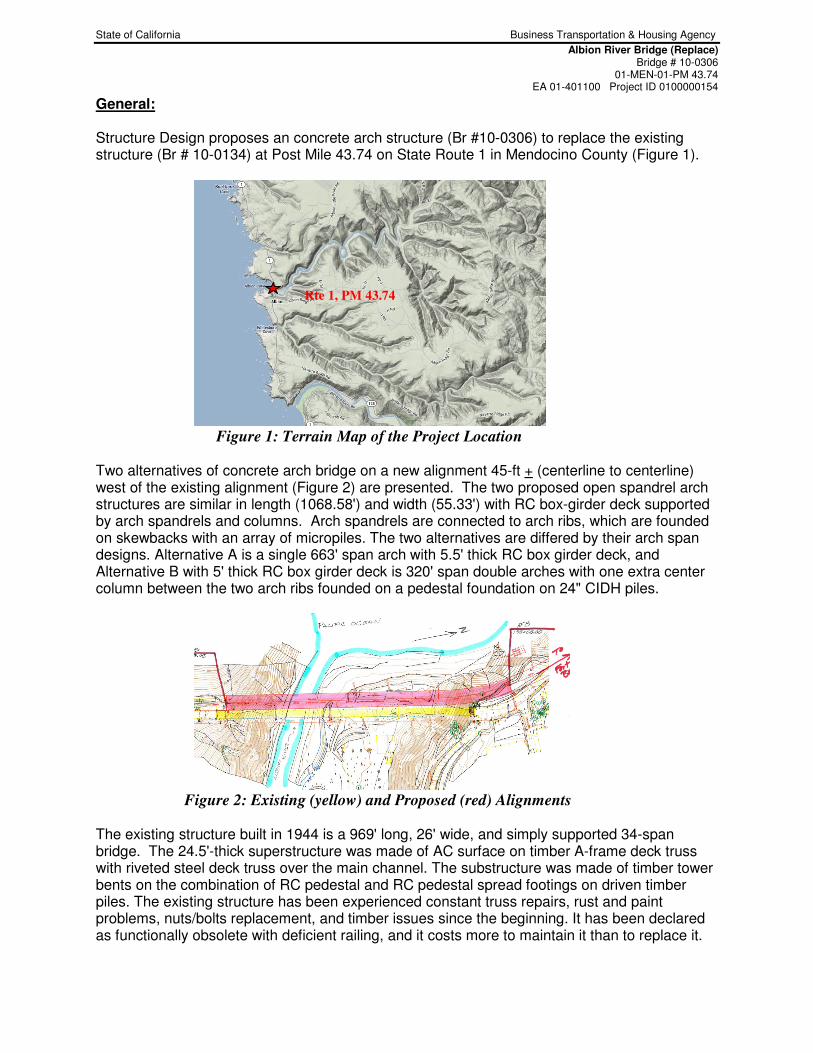
General: Structure Design proposes an concrete arch structure (Br #10-0306) to replace the existing structure (Br # 10-0134) at Post Mile 43.74 on State Route 1 in Mendocino County (Figure 1).
Figure 1: Terrain Map of the Project Location
Two alternatives of concrete arch bridge on a new alignment 45-ft + (centerline to centerline) west of the existing alignment (Figure 2) are presented. The two proposed open spandrel arch structures are similar in length (1068.58') and width (55.33') with RC box-girder deck supported by arch spandrels and columns. Arch spandrels are connected to arch ribs, which are founded on skewbacks with an array of micropiles. The two alternatives are differed by their arch span designs. Alternative A is a single 663' span arch with 5.5' thick RC box girder deck, and Alternative B with 5' thick RC box girder deck is 320' span double arches with one extra center column between the two arch ribs founded on a pedestal foundation on 24" CIDH piles.
Figure 2: Existing (yellow) and Proposed (red) Alignments The existing structure built in 1944 is a 969' long, 26' wide, and simply supported 34-span bridge. The 24.5'-thick superstructure was made of AC surface on timber A-frame deck truss with riveted steel deck truss over the main channel. The substructure was made of timber tower bents on the combination of RC pedestal and RC pedestal spread footings on driven timber piles. The existing structure has been experienced constant truss repairs, rust and paint problems, nuts/bolts replacement, and timber issues since the beginning. It has been declared as functionally obsolete with deficient railing, and it costs more to maintain it than to replace it.
Rte 1, PM 43.74
State of California Business Transportation & Housing Agency
Albion River Bridge (Replace) Bridge # 10-0306
01-MEN-01-PM 43.74 EA 01-401100 Project ID 0100000154
2
The report makes reference to:
• Roadway Survey data (NAVD 1988) from District Survey (01/2011)
• Caltrans Bridge Maintenance Records, field reviews, and As-Built plans.
• HEC-18, Evaluating Scour At Bridge 5th edition (April, 2012), published by Federal Highway Administration, US Department of Transportation
• HEC-25, Highways in the Coastal Environment (2nd Edition, 02/2008), published by Federal Highway Administration, US Department of Transportation
• Probabilistic Tsunami Hazard in California by Pacific Earthquake Engineering Research Center (PEER, 10/ 2010)
• Flood Insurance Study (FIS) for Mendocino County published by Federal Emergency Management Agency (FEMA, 06/02/2011)
• Guidance on Incorporating Sea Level Rise by California Department of Transportation (Caltrans, 5/16/2011)
• Preliminary GP (01/04/2014) & BSS (12/19/2013) from Structure Design
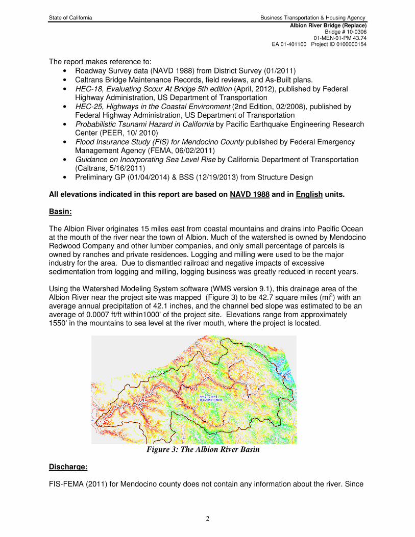
All elevations indicated in this report are based on NAVD 1988 and in English units. Basin: The Albion River originates 15 miles east from coastal mountains and drains into Pacific Ocean at the mouth of the river near the town of Albion. Much of the watershed is owned by Mendocino Redwood Company and other lumber companies, and only small percentage of parcels is owned by ranches and private residences. Logging and milling were used to be the major industry for the area. Due to dismantled railroad and negative impacts of excessive sedimentation from logging and milling, logging business was greatly reduced in recent years. Using the Watershed Modeling System software (WMS version 9.1), this drainage area of the Albion River near the project site was mapped (Figure 3) to be 42.7 square miles (mi2) with an average annual precipitation of 42.1 inches, and the channel bed slope was estimated to be an average of 0.0007 ft/ft within1000' of the project site. Elevations range from approximately 1550' in the mountains to sea level at the river mouth, where the project is located.
Figure 3: The Albion River Basin Discharge: FIS-FEMA (2011) for Mendocino county does not contain any information about the river. Since

State of California Business Transportation & Housing Agency
Albion River Bridge (Replace) Bridge # 10-0306
01-MEN-01-PM 43.74 EA 01-401100 Project ID 0100000154
3
the river is ungaged in a rural setting without any storage basins upstream, National Streamflow Statistics Method (NSS or Regional Regression Method) as a module of WMS is used to approximate the 50-year and 100-year flood events. For an ordinary flow, a flow of the 10-year event is also developed. The calculated discharges in cubic feet per second (cfs) are rounded to the nearest hundred in Table 1.
Table 1 Albion River Drainage Area = 42.7 mi2
, Channel slope = 0.0007 ft/ft Flood Frequency 10-year 50-year 100-year
Flow Rate, cfs 5,500 8,100 9,100
Tidal Influence, Sea Level Rise, & Tsunami Hazard: The project is located on the north coast of California between Mendocino Bay and Point Arena, and the location is subject to tidal influence, tsunami inundation, and sea level rise effect. These items ultimately affect on the water surface elevation (WSE) of the proposed structure and indirectly impact the waterway clearance of the proposed bridge. The closest tidal benchmark for the project is located at Arena Cove, CA (Station # 9416841), which is about 28 miles south of the project site, and it was checked and accepted by National Oceanic and Atmospheric Administration in December 2011. For the epoch of 1983-2001 at this tidal benchmark, Mean Higher High Water (MHHW) was 5.86' and Mean Lower Low Water (MLLW) was 0.00'. With the NAVD 88 datum located at Elevation 0.14', MHHW is then adjusted to be at Elev. 5.72', and MLLW at Elev. - 0.14' (NAVD 88). Tsunami events (i.e. earthquakes under water) occur when an underwater disturbance triggers a series of waves. In the report of Probabilistic Tsunami Hazard in California by Pacific Earthquake Engineering Research Center dated in October 2010, the closest studied site was located at Fort Bragg, which is about 16 miles north of the project site, the tsunami wave height is 1-meter (3.28') for 100-year return period. The gradual increase of the sea level has been documented, and the rate of the long-term sea level rise was determined by National Academy of Sciences (NAS) and adapted by Caltrans (Guidance on Incorporating Sea Level Rise, 5/16/2011). According the latest release news from NAS (June 2012), the sea level is projected to rise 167 centimeters (5.48') by 2100 for California coast south of Cape Mendocino. HEC-RAS Model Preparation and Parameters:
• US Army Corps of Engineers' hydraulic analysis software - HEC-RAS 4.1.0 was used to create the one dimensional model for this project.
• Topographic composite (NAVD 88) of the roadway survey and 10-meter DEM was generated in WMS for the cross-sections needed in the detailed study, noted the roadway survey was shy on the channel data within the project proximity.
• Flood events (Q100= 9,100 cfs and Q50= 8,100) are used.
• The preliminary General Plans, as-built plans, and aerial photos were referenced for the specific locations and dimensions of the structures.
• Roughness coefficients of 0.04 for the overbanks and 0.03 for the main channel.
• Under the steady flow module, subcritical flow regime with downstream control of a known water surface elevation is applied due to the flatness of the channel slope (0.0007 ft/ft).
State of California Business Transportation & Housing Agency
Albion River Bridge (Replace) Bridge # 10-0306
01-MEN-01-PM 43.74 EA 01-401100 Project ID 0100000154
4
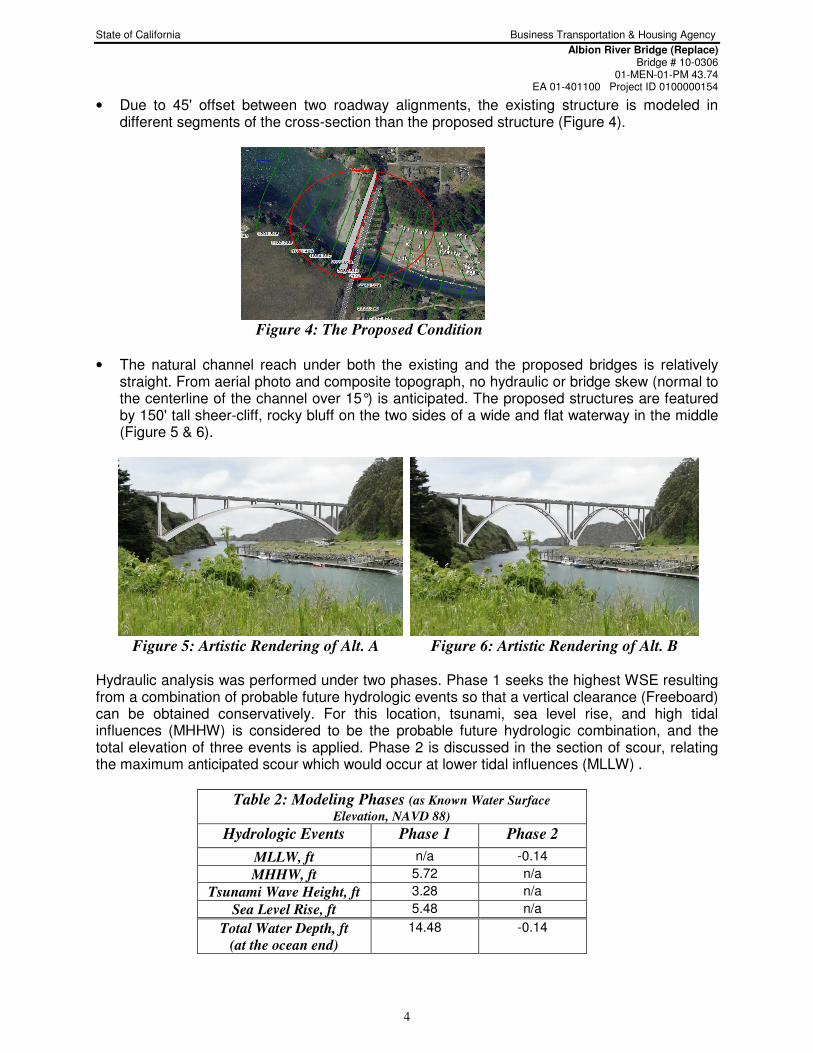
• Due to 45' offset between two roadway alignments, the existing structure is modeled in different segments of the cross-section than the proposed structure (Figure 4).
Figure 4: The Proposed Condition
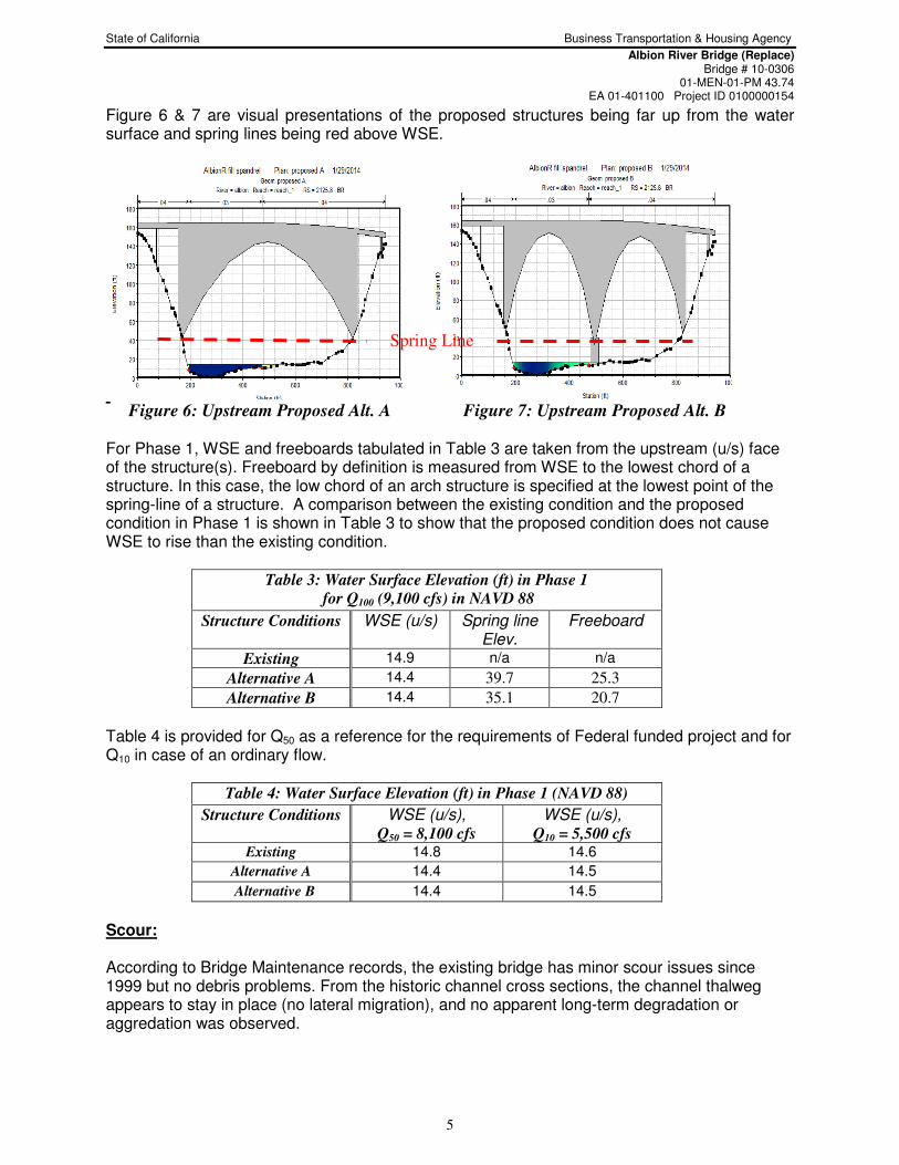
• The natural channel reach under both the existing and the proposed bridges is relatively straight. From aerial photo and composite topograph, no hydraulic or bridge skew (normal to the centerline of the channel over 15°) is anticipated. The proposed structures are featured by 150' tall sheer-cliff, rocky bluff on the two sides of a wide and flat waterway in the middle (Figure 5 & 6).
Figure 5: Artistic Rendering of Alt. A Figure 6: Artistic Rendering of Alt. B Hydraulic analysis was performed under two phases. Phase 1 seeks the highest WSE resulting from a combination of probable future hydrologic events so that a vertical clearance (Freeboard) can be obtained conservatively. For this location, tsunami, sea level rise, and high tidal influences (MHHW) is considered to be the probable future hydrologic combination, and the total elevation of three events is applied. Phase 2 is discussed in the section of scour, relating the maximum anticipated scour which would occur at lower tidal influences (MLLW) .
Table 2: Modeling Phases (as Known Water Surface
Elevation, NAVD 88)
Hydrologic Events Phase 1 Phase 2
MLLW, ft n/a -0.14
MHHW, ft 5.72 n/a
Tsunami Wave Height, ft 3.28 n/a
Sea Level Rise, ft 5.48 n/a
Total Water Depth, ft
(at the ocean end)
14.48 -0.14
State of California Business Transportation & Housing Agency
Albion River Bridge (Replace) Bridge # 10-0306
01-MEN-01-PM 43.74 EA 01-401100 Project ID 0100000154
5
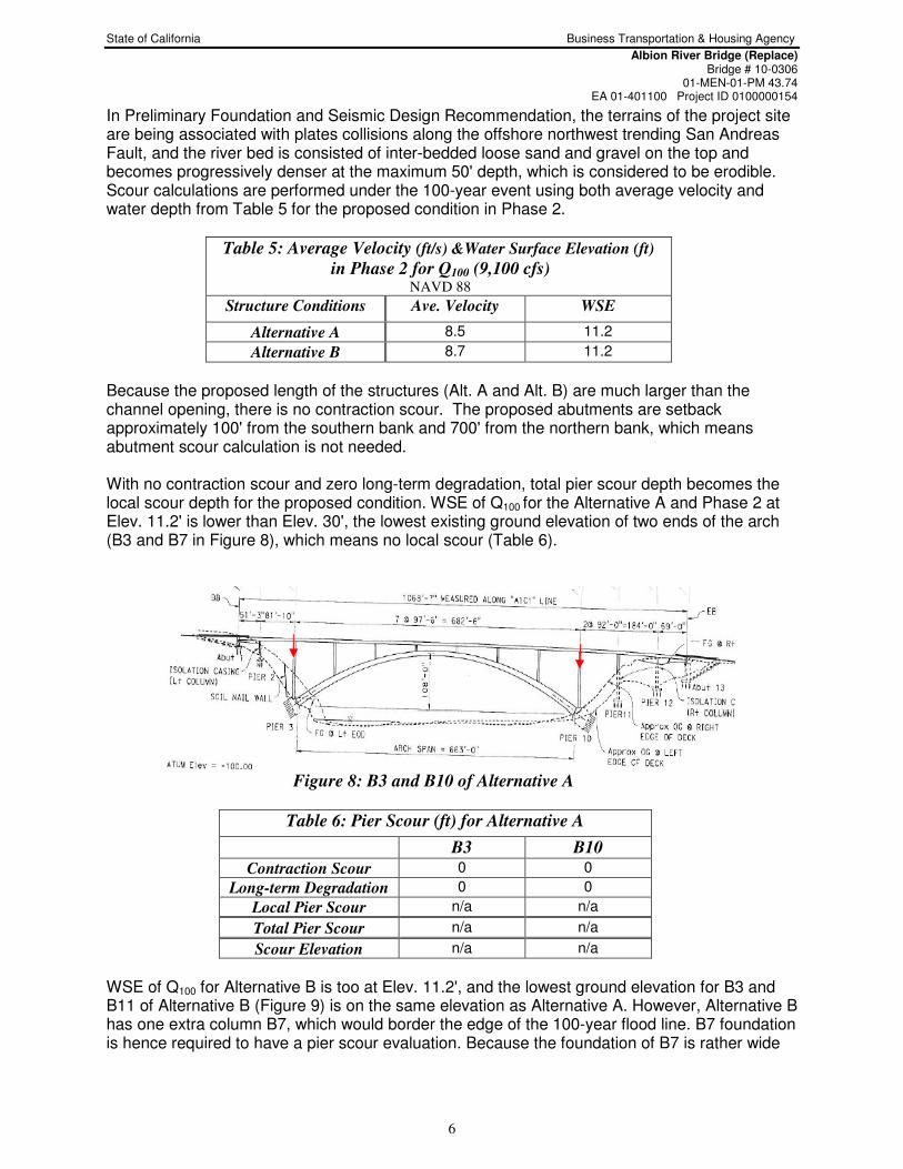
Figure 6 & 7 are visual presentations of the proposed structures being far up from the water surface and spring lines being red above WSE.
Figure 6: Upstream Proposed Alt. A Figure 7: Upstream Proposed Alt. B For Phase 1, WSE and freeboards tabulated in Table 3 are taken from the upstream (u/s) face of the structure(s). Freeboard by definition is measured from WSE to the lowest chord of a structure. In this case, the low chord of an arch structure is specified at the lowest point of the spring-line of a structure. A comparison between the existing condition and the proposed condition in Phase 1 is shown in Table 3 to show that the proposed condition does not cause WSE to rise than the existing condition.
Table 3: Water Surface Elevation (ft) in Phase 1
for Q100 (9,100 cfs) in NAVD 88
Structure Conditions WSE (u/s) Spring line Elev.
Freeboard
Existing 14.9 n/a n/a
Alternative A 14.4 39.7 25.3
Alternative B 14.4 35.1 20.7
Table 4 is provided for Q50 as a reference for the requirements of Federal funded project and for Q10 in case of an ordinary flow.
Table 4: Water Surface Elevation (ft) in Phase 1 (NAVD 88)
Structure Conditions WSE (u/s), Q50 = 8,100 cfs
WSE (u/s), Q10 = 5,500 cfs
Existing 14.8 14.6
Alternative A 14.4 14.5
Alternative B 14.4 14.5
Scour: According to Bridge Maintenance records, the existing bridge has minor scour issues since 1999 but no debris problems. From the historic channel cross sections, the channel thalweg appears to stay in place (no lateral migration), and no apparent long-term degradation or aggredation was observed.
Spring Line
State of California Business Transportation & Housing Agency
Albion River Bridge (Replace) Bridge # 10-0306
01-MEN-01-PM 43.74 EA 01-401100 Project ID 0100000154
6
In Preliminary Foundation and Seismic Design Recommendation, the terrains of the project site are being associated with plates collisions along the offshore northwest trending San Andreas Fault, and the river bed is consisted of inter-bedded loose sand and gravel on the top and becomes progressively denser at the maximum 50' depth, which is considered to be erodible. Scour calculations are performed under the 100-year event using both average velocity and water depth from Table 5 for the proposed condition in Phase 2.
Table 5: Average Velocity (ft/s) &Water Surface Elevation (ft)
in Phase 2 for Q100 (9,100 cfs) NAVD 88
Structure Conditions Ave. Velocity WSE
Alternative A 8.5 11.2
Alternative B 8.7 11.2
Because the proposed length of the structures (Alt. A and Alt. B) are much larger than the channel opening, there is no contraction scour. The proposed abutments are setback approximately 100' from the southern bank and 700' from the northern bank, which means abutment scour calculation is not needed. With no contraction scour and zero long-term degradation, total pier scour depth becomes the local scour depth for the proposed condition. WSE of Q100 for the Alternative A and Phase 2 at Elev. 11.2' is lower than Elev. 30', the lowest existing ground elevation of two ends of the arch (B3 and B7 in Figure 8), which means no local scour (Table 6).
Figure 8: B3 and B10 of Alternative A
Table 6: Pier Scour (ft) for Alternative A
B3 B10
Contraction Scour 0 0
Long-term Degradation 0 0
Local Pier Scour n/a n/a
Total Pier Scour n/a n/a
Scour Elevation n/a n/a
WSE of Q100 for Alternative B is too at Elev. 11.2', and the lowest ground elevation for B3 and B11 of Alternative B (Figure 9) is on the same elevation as Alternative A. However, Alternative B has one extra column B7, which would border the edge of the 100-year flood line. B7 foundation is hence required to have a pier scour evaluation. Because the foundation of B7 is rather wide

State of California Business Transportation & Housing Agency
Albion River Bridge (Replace) Bridge # 10-0306
01-MEN-01-PM 43.74 EA 01-401100 Project ID 0100000154
7
(30'), the local pier scour equation with consideration of extra wide pier (kw) according to HEC-18 was applied. The total scour depth for B7 in this case is the local scour depth (Table 7).
Figure 9: B3, B7, and B11 of Alternative B
Table 7: Pier Scour (ft) for Alternative B
B3 B7 B10
Contraction Scour 0 0 0
Long-term Degradation 0 0 0
Local Pier Scour 0 34.0' 0
Total Pier Scour 0 34.0' 0
Thalweg Elevation 1.4'
Scour Elevation n/a -32.6' n/a
Summary & Recommendations:
• There is a minor issue with the roadway survey data which didn't have enough channel info. Once the detailed channel survey is completed, the models will be updated and the hydraulic results will be refined accordingly. At this point, the refinement is predicted to be incremental and the effect will mostly be on the campground/parking lot or trailer park in the channel. The proposed design is not anticipated to change with the newer survey.
• Neither Alternative A or B will have freeboard issues.
• The proposed foundations for Alternative A will not encounter water and hence no pier scour or abutment scour calculation is needed.
• Only Bent 7 of the proposed Alternative B will encounter water, and the scour calculation indicates that the B7 foundation will need to be below Elev. -30.5' to minimize scour risks in the future.
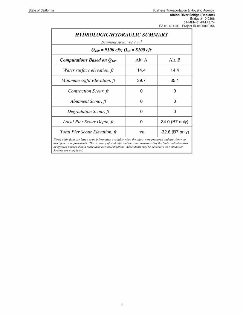
• The proposed structures meet current hydraulic requirements for this crossing. A hydrologic summary for the proposed structures is provided in Table below.
State of California Business Transportation & Housing Agency
Albion River Bridge (Replace) Bridge # 10-0306
01-MEN-01-PM 43.74 EA 01-401100 Project ID 0100000154
8
HYDROLOGIC/HYDRAULIC SUMMARY
Drainage Area: 42.7 mi2
Q100 = 9100 cfs; Q50 = 8100 cfs
Computations Based on Q100 Alt. A Alt. B
Water surface elevation, ft 14.4 14.4
Minimum soffit Elevation, ft 39.7 35.1
Contraction Scour, ft 0 0
Abutment Scour, ft 0 0
Degradation Scour, ft 0 0
Local Pier Scour Depth, ft 0 34.0 (B7 only)
Total Pier Scour Elevation, ft n/a -32.6 (B7 only)
Flood plain data are based upon information available when the plans were prepared and are shown to
meet federal requirements. The accuracy of said information is not warranted by the State and interested
or affected parties should make their own investigation. Addendums may be necessary as Foundation
Reports are completed.