Embed Size (px)
Citation preview

0

1
Introduction
10 Leach Road, Lyons, New York 14489 Telephone/Fax (315) 946-4136 waynecountyNYsoilandwater.org
Credits: Cayuga, Chenango, Madison, and Onondaga Soil and Water Conservation Districts Envirothon Study Guide, United States Department of Agriculture, North American Envirothon Study Guide, NY State Envirothon information packet, NY State Envirothon website.
Welcome to the Wayne County NY Envirothon! Wayne County Soil and Water Conservation District has put together this study guide to assist with classroom education. The following pages contain shared resources to assist Envirothon teams preparing for competition. Each resource supports the “Envirothon Learning Objectives.”
The 2017 Wayne County Envirothon will be held at Montezuma Audubon Center in Savannah, NY on Wednesday April 12th, 2017
Envirothon is a unique and exciting program that combines hands-on outdoor experience with co-curricular environmental science study. High school students interested in outdoor fun and environmental science gather to sharpen their conservation skills and test their knowledge against teams of students from other schools in Wayne County. The winning team then advances to the State level to compete at the New York State Envirothon against other County champion teams; New York State champions proceed to the North American Envirothon. On the day of the competition student teams rotate through six ―eco-stations and answer written questions and conduct hands-on investigation of environmental issues in five categories Aquatic Ecology, Forestry, Soils/Land Use, Wildlife, Current Environmental Issue, and Oral Presentation on the Current Environmental issue.
The 2017 Current Environmental Issue is Agricultural Soil and Water Conservation Stewardship.
At the sixth station, each team gives a 15-minute presentation on the Current Environmental Issue to a panel of judges. Teams have been researching the issue in their own community in preparation for their presentation. Each panel of judges includes concerned citizens and environmental professionals from government agencies, non-profit organizations, academia and private industry. Competing teams are asked to assess how the issue may affect their community and to recommend steps that their city or town and individuals should take to respond to the challenge.
For more information, questions or to enroll in the 2017 Wayne County Envirothon contact Drew Starkey at [email protected]

Table of Contents Aquatic Ecology Introduction ............................................................................................... 4-5
Learning Objectives................................................................................................................. 6
Outline .................................................................................................................................... 7
Sample Questions ................................................................................................................. 8-9
Recommended Resources ...................................................................................................... 10
Glossary of Terms ............................................................................................................ 11-14
What do Aquatic Ecologists Do? ........................................................................................... 15
Forestry Introduction ........................................................................................................ 16-17
Learning Objectives............................................................................................................... 18
Outline .................................................................................................................................. 19
Sample Questions ............................................................................................................. 20-21
Recommended Resources ...................................................................................................... 22
Glossary of Terms ............................................................................................................ 23-27
Forestry Field Exercises ................................................................................................... 28-30
What does a Forester Do? ...................................................................................................... 31
Soils and Land Use Introduction ....................................................................................... 32-33
Learning Objectives............................................................................................................... 34
Outline .................................................................................................................................. 35
Skills, Sample Questions .................................................................................................. 36-38
Use of Soil Survey Reports .................................................................................................... 39
Soil Skills True or False ........................................................................................................ 40
Land Capability Classifications ............................................................................................. 41
Recommended Resources ...................................................................................................... 42
Glossary of Terms ............................................................................................................ 43-45
The Principals of Soil ....................................................................................................... 46-49
What do Soil Scientists Do? .................................................................................................. 50
Notes ..................................................................................................................................... 51
2

Wildlife Introduction ............................................................................................................. 52
Learning Objectives............................................................................................................... 53
Outline .................................................................................................................................. 54
Wildlife Identifications .......................................................................................................... 55
Sample Questions ............................................................................................................. 56-57
Recommended Resources ...................................................................................................... 58
Glossary of Terms ............................................................................................................ 59-62
Suggested Activities .............................................................................................................. 63
What does a Wildlife Biologist Do? ....................................................................................... 64
Notes ..................................................................................................................................... 65
Oral Presentation Introduction .............................................................................................. 66
Oral Presentation Rules ......................................................................................................... 67
Sample Judges Sheet (2016) ............................................................................................. 68-69
Current Environmental Issue ................................................................................................. 70
Learning Objectives............................................................................................................... 71
3
Aquatic Ecology INTRODUCTION
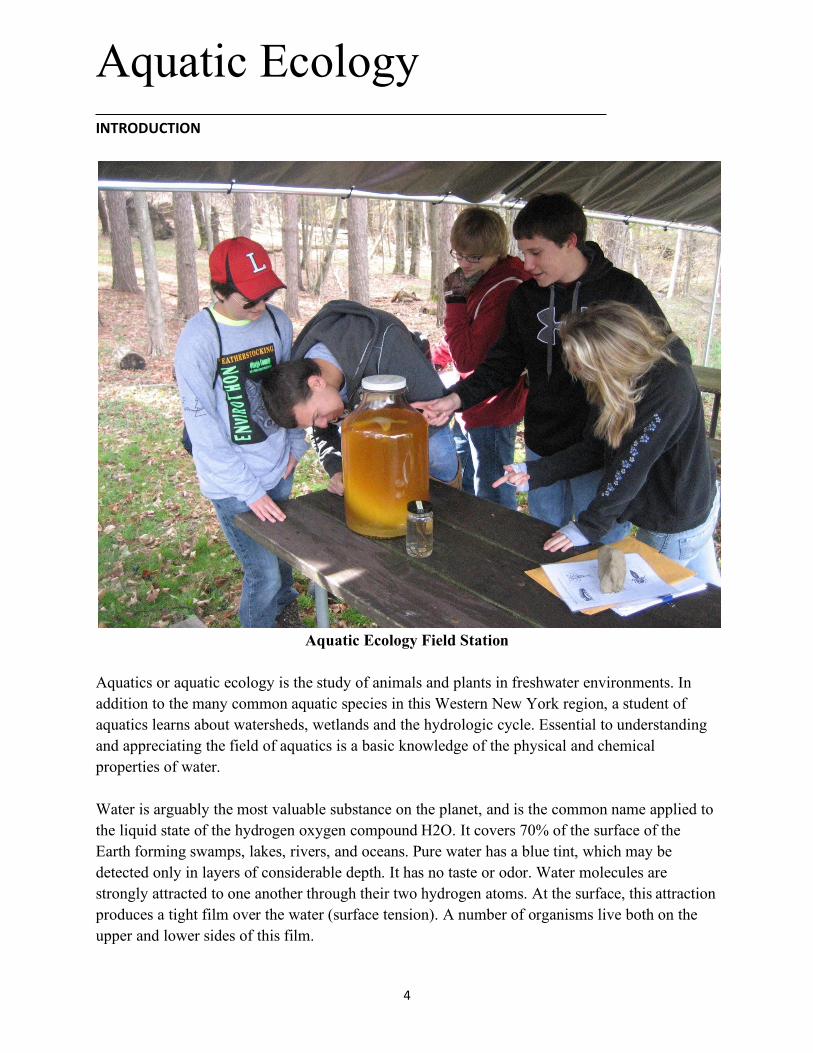
Aquatic Ecology Field Station
Aquatics or aquatic ecology is the study of animals and plants in freshwater environments. In addition to the many common aquatic species in this Western New York region, a student of aquatics learns about watersheds, wetlands and the hydrologic cycle. Essential to understanding and appreciating the field of aquatics is a basic knowledge of the physical and chemical properties of water.
Water is arguably the most valuable substance on the planet, and is the common name applied to the liquid state of the hydrogen oxygen compound H2O. It covers 70% of the surface of the Earth forming swamps, lakes, rivers, and oceans. Pure water has a blue tint, which may be detected only in layers of considerable depth. It has no taste or odor. Water molecules are strongly attracted to one another through their two hydrogen atoms. At the surface, this attraction produces a tight film over the water (surface tension). A number of organisms live both on the upper and lower sides of this film.
4

Density of water is greatest at 39.2° Fahrenheit (4° Celsius). It becomes less as water warms and, more important, as it cools to freezing at 32° Fahrenheit (0° Celsius), and becomes ice. Ice is a poor heat conductor. Therefore, ice sheets on ponds, lakes and rivers trap heat in the water below. For this reason, only very shallow water bodies never freeze solid.
Water is the only substance that occurs at ordinary temperatures in all three states of matter: solid, liquid, and gas. In its solid state, water is ice, and can be found as glaciers, snow, hail, and frost and ice crystals in clouds. It occurs in the liquid state as water droplets in rain clouds, and on vegetation as dew. Under the influence of gravity, water may accumulate in the openings of hard rock beneath the surface of the earth. This groundwater sustains wells, springs and some streams. As a gas, or water vapor, it occurs as fog, steam, clouds, and humidity.
The transparency of water permits enough light to penetrate for plants to carry on photosynthesis and animals to thrive. The depths to which light can penetrate decrease as water contains more suspended materials and becomes turbid (or less clear). Less light means fewer plants can grow, thus attracting less wildlife.
Our dependence upon water and competition for it have imperiled and will continue to threaten aquatic environments and the organisms living in them. Good water quality is essential for aquatic life as well as for the human species. Recently, the historical emphasis on political entities, such as counties, towns, villages and cities, has shifted to watersheds. It has been said that one-third of the world¹s population will experience a water shortage crisis in 2025. Wars in the future may well be fought for water rather than for oil! Source for text on water properties:
Reference: NYC Envirothon Resource Packet, Central New York Regional Envirothon Study Guide
5

AQUATICECOLOGY-LEARNINGOBJECTIVES
For successful completion of the aquatics section, contestants should be able to:
Know the processes and phases for each part of the water cycle and understand the water cycle's role in soil erosion, groundwater recharge, and climatic influences.
Understand the concept and components of a watershed and be able to identify stream orders and watershed boundaries. Know the features of a healthy watershed and an unhealthy watershed.
Know how to interpret water and biological quality tests and understand why aquatic organisms and water quality is affected by the physical, chemical and biological conditions of the water and how it impacts aquatic environments.
Understand the dependence of all organisms on one another and how energy and matter flow within an aquatic ecosystem.
Understand the concept of carrying capacity for a given aquatic ecosystem, and be able to discuss how water usage may affect the ability of the system to sustain different needs.
Identify common, rare, threatened and endangered aquatic species as well as aquatic invasive species.
Identify aquatic and wetland environments based on their physical, chemical and biological characteristics.
Know characteristics of different types of aquifers, and understand historical trends and threats to groundwater quantity and quality.
Understand the benefits and ecological functions and values of riparian zones, wetlands and open water systems and be able to identify the associated zone areas.
Be familiar with both NYS and federal water protection laws and the agencies that enforce those laws. Understand the requirements for required permits.
Understand concepts and practices to manage non-point source pollution from agricultural, forest and land under development.
Be familiar with general terminology and definitions pertaining to the subject area.
6
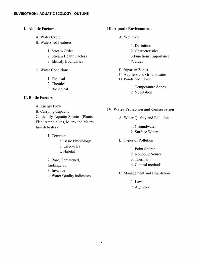
ENVIROTHON:AQUATICECOLOGY-OUTLINE
I. Abiotic Factors III. Aquatic Environments
Water Cycle Watershed Features
A. Wetlands
Definition Characteristics
3.Functions /Importance /Values
Stream Order Stream Health Factors Identify Boundaries
C. Water Conditions Riparian Zones Aquifers and Groundwater Ponds and Lakes
Temperature Zones Vegetation
Physical Chemical Biological
II. Biotic Factors
Energy Flow Carrying Capacity Identify Aquatic Species (Plants,
Fish, Amphibians, Micro and Macro Invertebrates)
IV. Water Protection and Conservation
A. Water Quality and Pollution
Groundwater Surface Water
1. Common Basic Physiology Lifecycles Habitat
B. Types of Pollution
Point Source Nonpoint Source Thermal Control methods
2. Rare, Threatened, Endangered 3. Invasive 4. Water Quality indicators
C. Management and Legislation
1. Laws 2. Agencies
7

ENVIROTHON:AQUATICECOLOGY-SAMPLEQUESTONS
1. A lake ecosystem is termed “phosphorous limited” if:
a. adding nitrogen to the lake causes increased phytoplankton growth
b. adding phosphorus to the lake causes increased phytoplankton growth
c. adding nitrogen to the lake causes decreased phytoplankton growth
d. adding phosphorus to the lake causes decreased hytoplankton growth
e. adding phosphorus to the lake causes no change in phytoplankton growth
2. Pacific salmon (Onchorhyncus spp.) are an example of the “anadromy” life history because they do which of the following:
a. fish spend most of their lives in freshwater and then migrate to the sea for breeding
b. fish spawn in freshwater but juveniles drift back to the ocean where adults spend most of their lives
c. adult female fish die immediately after spawning
d. adults can metamorphose from male to female under high density pressures
e. none of the above
3. Which of the following would NOT be considered a benthic macroinvertebrate organism?
a. Diatom
b. Decapod
c. Gastropod
d. Ephemeroptera
e. Bivalvia
4. The water in jar “A” was collected from the surface of a mesotrophic system; the water in jar “B” was collected from the surface of a eutrophic system. What physical parameter should show the greatest difference between these two water samples?
a. Temperature b. Dissolved oxygen concentration c. Turbulence d. Turbidity e. Salinity
8

5. Identify the creature making this call by listening to the tape.
a. Wood frog
b. Pickerel frog
c. Spring peeper
d. Green frog
6. If a New York state stream contains a wild trout population then a permit is required to construct a road crossing it. Which of the following agencies would issue the needed permit?
a. United States Fish and Wildlife Service
b. Soil and Water Conservation District
c. New York State Department of Environmental Conservation
d. United States Environmental Protection Agency
e. New York State Department of Transportation
7. Because they produce so much plant biomass and invertebrate life, estuaries and their coastal marshes serve as important nursery areas for the young of many game (recreational) and commercial fish and shellfish. Which of the following fish species is dependent upon coastal wetlands?
a. Brown trout
b. Atlantic chad
c. Northern pike
d. Flounder
8. One of the main functions of a healthy watershed is the temporarily storage and transportation of water from the land surface to the water body. Over time, streams develop into defined drainage networks. Which of the following is not a recognized drainage pattern?
a. Parallel c. Angular
b. Spiral d. Dendritic
9

______________________________________________________________________________ENVIROTHON:AQUATICECOLOGYRECOMMENDEDRESOURCES
I. Abiotic Factors Key, Macro Invertebrates (1), Macro Invertebrates (3) Pond Habitat
Water Science Basics, Watershed, Stream Classisfication Non Point Source Pollution
II. Biotic Factors After The Storm, Buffer Fact Sheet
Primers for Aquatic Plants, Order, Order & Classification, Pond Stream, Watermilfoil
Eurasian Wetlands Economic Benefits of Wetlands Overview
III. Aquatic Environments Links
Threats to Wetlands, Wetland Types, US EPA Wetlands, Wetland Functions, Benefits of Wetland for Amphibians & Reptiles, Lacustine, Palustine, Ranks Glossary, Riverine, Terrestrial System, Aquifers, Groundwater, Mgt. Fish Ponds In PA
North America Native Fishes Association
NatureNorth.com USGS Nonindigenous Aquatic Species
NatureSongs.com Cortland Herpetology Connection
IV. Water Protection and Conservation LEFT for Aquatic and Invasive Plants Urban Runoff Fact Sheet, Managing NPS
from Agriculture, Managing NPS from Households, Clean Water Act, Wetland Regulation Authority
NYS DEC Facts About the Waters of New York State
NYS DEC Key to Aquatic Macroinvertebrates
Aquatic Ecology
Aquatic Plants, Vegetation & Algae, Controlling Aquatic Vegetation, Identification, Use & Benefits of Aquatic Plants
NYS DEC Saving Water Makes Good Sense
NYS DEC Getting the Most (Out) Of Your Aquatic Plants Communities of NYS
Introduction, System Key NYS DEC Color Brochures and Posters of Wildlife in New York State as first seen in the Conservationist magazine
Ponds , Marcoinvertebrates Aquatic Ecology, Caddis, Macro
10

______________________________________________________________________________ENVIROTHON:AQUATICECOLOGYGLOSSARY
capture and filter runoff from adjoining land uses.
Acid rain: rain containing pollutants that Channelization: the practice of straightening a water course or stream to remove meanders and make the water flow faster. Sometimes concrete is used to line the sides and bottom.
give it a pH of less than 7.0.
Algae: photosynthetic organisms with a one-celled or simple multi-cellular body plan.
Cobble stone: 2-10 inch size stones where stream life can be found.
Aqueous: containing or composed largely of water.
Coliform Bacteria: a group of bacteria found in cold and warm blooded animal intestines commonly used as indicators of pathogens.
Aquifer: a land, gravel or rock formation capable of storing or conveying water below the surface of the land.
B Cultural Eutrophication: process whereby human activity increases the amount of nutrients entering surface waters.
Bacteria: unicellular microorganisms of the class Schizomycetes existing as free living organisms or parasites.
Culvert: a closed passageway (such as a pipe)under roadways and embankments which drains surface water.
Benthos: bottom dwelling or substrate- oriented organisms.
Best Management Practices: a practice or combination of practices that provide an effective, practical means of preventing or reducing pollution from non-point sources.
Decomposition: the separating or decaying of organic or chemical matter.
Dendritic: a pattern of stream drainage that resembles the pattern of a tree.
Bioaccumulate: the practice of concentrating a particular substance over time.
Density of water: Is greatest at 4°(39.2°F). Biomonitoring: the use of organisms to assess or monitor environmental conditions.
Dilute and disperse: the practice of discharging a substance into a large body of water that will carry the substance away from its source and reduce its concentration.
Biochemical Oxygen Demand (BOD): a measure of the quantity of oxygen used by microorganisms in the aerobic oxidation of organic matter. Discharge: the flow of surface water in a
stream or canal or the outflow of groundwater from a flowing artesian well, ditch or spring.
Brook: a small stream Buffer: a vegetated area of grass, shrubs or trees designed to
11

Discharge pipe: a pipe used to carry wastewater from a factory or other facility into a receiving stream or lake.
G
Groundwater: water beneath the earth's surface between saturated soil and rock.
Dissolved oxygen: oxygen dissolved in water which is readily available to plants and animals.
H
Habitat: the area or environment in which an organism lives. Drainage basin: a large watershed usually
referring to the combination of several watersheds. Hardness: a characteristic of water caused
by the presence of various salts, calcium, magnesium and iron. E
Ecology: the science of the relationships between organisms and their environments.
Headwaters: the uppermost reaches of a river or stream.
Ecosystem: an ecological community together with its physical environment, usually considered as a unit.
Hydric soils: soils found in saturated, anaerobic environments usually characterized by gray or mottled appearance, found in wetlands.
Ephemeral Stream: a stream that flows only during wet periods or rainstorms. Hydrologic cycle: the series of pathways
the earth's water may take on its journey from the sea to the atmosphere to the land and ultimately back to the sea.
Epilimnion: topmost layer of water in a lake.
Estuary: an arm of the sea that extends inland to meet the mouth of a river, usually characterized by tidal changes and rich diversity of aquatic life.
Hydrologic unit: all land and water within a drainage area.
Hypolimnion: lower layer of water in a lake. Infiltration: the downward entry of water into the soil. Eutrophication: a process in which
organic matter accumulates in a body of water until eventually it fills in and becomes dry land.
Instar: the individual insect between two molting events or an organism between egg hatching and the first larval molt.
F
Fecal coliform: that part of the coliform group of bacteria originating in the intestinal tract of warm blooded animals.
Intermittent stream: a stream which has an interrupted flow or does not flow continuously.
Floodplain: a low area of land, surrounding streams or rivers, which holds the overflow of water during a flood.
L
Larvae: the plural of larva, the first major mobile life stage of an insect or first development following egg hatching.
Freshwater: water that is not saline or brackish.
12

Lentic: standing water as in a lake. Perennial stream: a stream which flows continually.
Limiting factor: something that determines the presence, survival and success of an organism.
pH: a symbol used to indicate how acidic or basic a solution is.
Limnology: the study of inland water: ponds, lakes and streams.
Phosphorus: an important nutrient for life, especially plants and algae.
Littoral: region of shallow water where light reaches the bottom. Lotic: running water as in a river.
Plankton: collective word for microscopic organisms that drift around in the upper level of a body of water.
Point source pollution: Pollution that is discharged through a pipe or other conduit and is usually a regulated discharge.
M
Macroinvertebrates: an animal without a backbone visible to the naked eye or larger than 0.5 Pollutant: any substance or mixture of
substances that defile or contaminate the soil, water or atmosphere. Meander: the circuitous winding or
sinuosity of a stream, used to refer to a bend in the river. Pond: a quiet body of water so shallow that
rooted plants usually grow completely across it. Monitoring: to watch and care for a stream
on a regular basis. Profoudal: region of water below photosynthetic light penetration.
Nitrate: an important nutrient for building protein in plants and animals.
Riffle: a hallow section of a stream where water bubbles over rocks, often found at the bend in a river.
Nonpoint source pollution (NPS): pollution that originates from many diffuse sources and usually is not regulated, such as runoff from streets that carries with it oil, feces and sediment.
Riparian: relating to the banks of a stream or river.
O River: a body of running water of considerable volume usually moving over the earth's surface in a channel or bed. Oligotrophic: a body of fresh water that
contains few nutrients and few organisms. Run: the straight section in a river between riffles, also refers to fish migration. P
Part per million (ppm): the quantity of one substance contained in one million units of another substance. Equivalent to milligram per liter(mg/l).
Runoff: water, including rain and snow, which is not absorbed into the ground: instead it flows across the land and eventually runs into streams and rivers. Runoff can pick up pollutants from the air and land, carrying them into the stream.
13
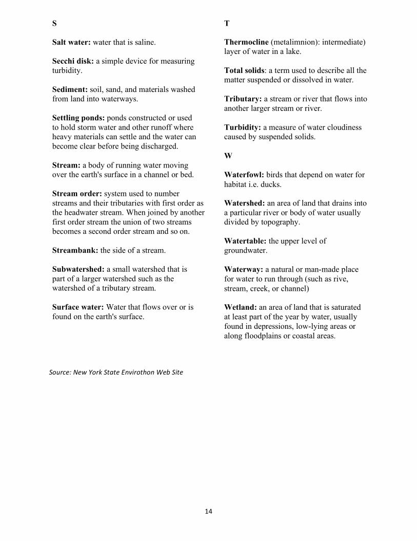
T
Salt water: water that is saline. Thermocline (metalimnion): intermediate) layer of water in a lake.
Secchi disk: a simple device for measuring turbidity. Total solids: a term used to describe all the
matter suspended or dissolved in water. Sediment: soil, sand, and materials washed from land into waterways. Tributary: a stream or river that flows into
another larger stream or river. Settling ponds: ponds constructed or used to hold storm water and other runoff where heavy materials can settle and the water can become clear before being discharged.
Turbidity: a measure of water cloudiness caused by suspended solids.
W Stream: a body of running water moving over the earth's surface in a channel or bed. Waterfowl: birds that depend on water for
habitat i.e. ducks. Stream order: system used to number streams and their tributaries with first order as the headwater stream. When joined by another first order stream the union of two streams becomes a second order stream and so on.
Watershed: an area of land that drains into a particular river or body of water usually divided by topography.
Watertable: the upper level of groundwater. Streambank: the side of a stream.
Subwatershed: a small watershed that is part of a larger watershed such as the watershed of a tributary stream.
Waterway: a natural or man-made place for water to run through (such as rive, stream, creek, or channel)
Surface water: Water that flows over or is found on the earth's surface.
Wetland: an area of land that is saturated at least part of the year by water, usually found in depressions, low-lying areas or along floodplains or coastal areas.
Source:NewYorkStateEnvirothonWebSite
14

What do Aquatic Ecologists Do? Water nourishes life. It is the single most important resource on the earth, and without it humans could not survive. Aquatic Ecologists study the earth‘s water systems; they monitor, research and analyze the relationship of aquatic organisms to one another and to their watery habitat. Aquatic Ecologists also observe microscopic life, chemical reactions, human impact, geologic activity and native as well as nonnative species within a specific aquatic environment. Through these observations they hope to garner an understanding of how aquatic ecosystems interact as a whole. They use the information gained from monitoring programs to determine future conservation and management strategies for aquatic ecosystems.
To become an Aquatic Ecologist one must first attend a four year bachelor‘s degree program at an accredited university. Graduates with majors in Environmental Science are the most prevalent in the field of Aquatic Ecology, but Aquatic Ecologists can also come from a varied scientific background including chemistry, geology, biology, climatology, statistics and even economics. In today‘s economy, postgraduate work in ecology or science is becoming a requirement for work in Aquatic Ecology research.
Aquatic Ecologists work many hours out of doors gathering data and just as many hours in the lab or behind a computer analyzing that field data. They often work with mathematical models analyzing and interpreting human actions and their effects on aquatic ecosystems. An Aquatic Ecologist must have strong verbal and writing skills in order to accomplish intensive research and present their findings in simple, concise and well-written oral reports and journal articles.
An Aquatic Ecologist may work with the government, a non-profit, or even in the corporate sector. They often work for government agencies such as the US EPA, US Fish and Wildlife Service, state environmental agencies, or local Soil and Water Districts.
Aquatic Ecologists can also become teachers, professors or researchers for private companies. A recent graduate can expect to make between $30,000 and $40,000 per year, or more depending on experience and the extent of their education.
Source: NYC Envirothon Resource Packet
15

Forestry INTRODUCTION
Forestry Station
The forestry station will focus on forests as ecosystems in New York State. Students will be expected to have a basic understanding of forested ecosystems, how they function and change over time, their role in a watershed, and why they are valuable resources.
In general, the word forestry means the propagation and management of forest trees for commercial harvest. This include the planting and management of exotic (nonnative) species, the existing native forest, and the genetic improvement of trees for selected characteristics, such as straight and rapid growth. Forestry also means the scientific study of tree growth, management, and timber production systems. The term forestry probably evokes visions of loggers, tree farms, and large tracts of woodlands. In heavily populated areas, however, forestry often encompasses an urban twist. Urban forestry is a relatively new term, originating in the 1960s in Canada. The concept of urban forestry will be prominently featured as a part of ecosystem management in the future. Urban forestry often applies to the planting and care of street and park trees, but also applies to restoration and management of natural forests in urban and suburban areas.
16

National forests provide vital ecosystem services, such as habitat for wildlife and native plants, act as water reservoirs and filters, take up carbon dioxide, release oxygen, and regenerate precious soil. In addition to ecosystem services, forests also provide humans with lumber, recreation areas, and aesthetic value. Forests store large amounts of carbon dioxide that might otherwise contribute to global warming, in the form of wood.
In the eastern US, deciduous hardwood forests characterize the dominant forest types. In the western US, coniferous evergreen forests dominate. In the United States, we have several major forest biomes including temperate deciduous forests, sub-tropical mixed forest, temperate mixed forest, temperate coniferous forest and taiga. Much of the forest area in the west still remains under public ownership, held as either national forest or Bureau of Management land. In the east, however, much of the surviving forests are under private ownership. Founded in 1905 by Gifford Pinchot, the United States Forest Service (part of the US Department of Agriculture) is the single-most important agency with reference to public forest land.
Students should be aware of and knowledgeable about the following: identification of common tree 14 species as well as tree parts and function; basic characteristics of forests and forest structure; forests as ecosystems; a general knowledge of forest history in our region; issues affecting forest health and management including invasive plants, fragmentation and urban sprawl; plant and animal communities that inhabit local forests; and silvicultural practices.
17
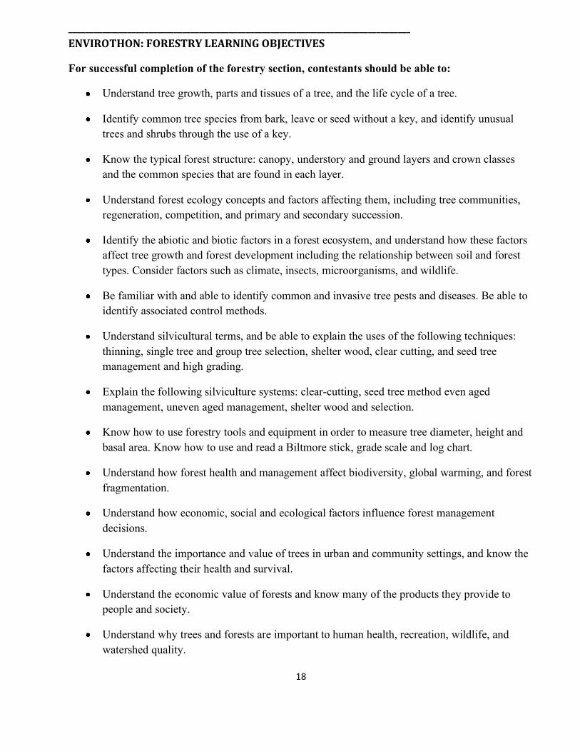
_________________________________________________________________________________ENVIROTHON:FORESTRYLEARNINGOBJECTIVES
For successful completion of the forestry section, contestants should be able to:
Understand tree growth, parts and tissues of a tree, and the life cycle of a tree.
Identify common tree species from bark, leave or seed without a key, and identify unusual trees and shrubs through the use of a key.
Know the typical forest structure: canopy, understory and ground layers and crown classes and the common species that are found in each layer.
Understand forest ecology concepts and factors affecting them, including tree communities, regeneration, competition, and primary and secondary succession.
Identify the abiotic and biotic factors in a forest ecosystem, and understand how these factors affect tree growth and forest development including the relationship between soil and forest types. Consider factors such as climate, insects, microorganisms, and wildlife.
Be familiar with and able to identify common and invasive tree pests and diseases. Be able to identify associated control methods.
Understand silvicultural terms, and be able to explain the uses of the following techniques: thinning, single tree and group tree selection, shelter wood, clear cutting, and seed tree management and high grading.
Explain the following silviculture systems: clear-cutting, seed tree method even aged management, uneven aged management, shelter wood and selection.
Know how to use forestry tools and equipment in order to measure tree diameter, height and basal area. Know how to use and read a Biltmore stick, grade scale and log chart.
Understand how forest health and management affect biodiversity, global warming, and forest fragmentation.
Understand how economic, social and ecological factors influence forest management decisions.
Understand the importance and value of trees in urban and community settings, and know the factors affecting their health and survival.
Understand the economic value of forests and know many of the products they provide to people and society.
Understand why trees and forests are important to human health, recreation, wildlife, and watershed quality.
18

_________________________________________________________________________________ENVIROTHON:FORESTRYOUTLINE
III. Sustainable Forest Management I. Tree Physiology and Tree and Shrub
Silvicultural Techniques: thinning, single tree or group tree selection, shelter wood, clear cutting, seed tree
Silviculture: clear-cutting , seed tree method, even aged management, uneven aged management, shelter wood and selection
Silviculture treatments: planting, thinning, harvesting
Identification
Identify parts of tree; including tissue of roots, stem, and leaves
By leaves, bark, flower or seed for trees listed in "Know Your Trees" without a key
By leaves, bark, flower or seed for uncommon trees using a key
II. Forest Ecology D. Forestry tools and equipment
Forest Structure Ecological Concepts and
terminology
1. 2. 3.
Basal Area Diameter Height
1. Relationship E. Factors influencing management decisions: ecological, financial, social between soil and forest
type 2. Levels of IV. Uses of Trees and Woods succession
A. Community Trees- their values, threats to them and challenges growing them
C. Factors influencing tree growth and forest development
1. climate, insects, microorganisms, and wildlife
B. Social and Economic Value
1. 2. protection 3.
Products Watershed
D. Forest Health
Wildlife 1. Identify common insects and diseases 2. species
Identify invasive
19

_________________________________________________________________________________
ENVIROTHON:FORESTRYSAMPLEQUESTIONS
1. What are two of the beneficial functions most tree roots provide a tree?
a. Nutrient sublimation and soil stabilization.
b. Water absorption and wildlife habitat.
c. Mechanical support and water absorption.
d. Water absorption and nitrogen fixing in the soil.
2. Greater economic return from multiple timber sales is achieved by ?
a. Periodic harvesting of trees which are over a specified diameter but, no more often than 10 years apart.
b. Use of a standard contract with every harvest.
c. Thinning out the largest trees, leaving some large and mostly small trees to grow.
d. Determining the stand structure, composition, age, health then developing a management plan.
3. Identify by species the trees numbered 1 through 7. Each of the lists below contains 5 tree species. Which list contains only tree species you have just identified?
a. Scotch (Scots) pine, Red oak, Basswood, White ash, Acer saccharinum
b. White ash, Larch, Sugar maple, Shagbark hickory, Quercus rubra
c. White pine, Red cedar, Sugar maple, Red oak, Fraxinus americana
d. Sugar maple, White cedar, White ash, Shagbark hickory, Prunus serotina
e. Red maple, Red cedar, White ash, Pitch pine, Quercus rubra
4. Which of the individual trees that you identified would be most valuable in terms of mast production for squirrels?
a. 1 c. 3
b. 2 d. 4
20
5. Measure the tree labeled number 4 for: D.B.H., merchantable saw-log height and, total height.
[When you are near the tree, you will notice a line marked on the ground and various distances from the tree are marked along this line. You may use this as needed or not.]
The correct results are:
a. 18ǁ, 2.5 logs, 75 feet b. 14ǁ, 24 ft., 80 feet c. 24ǁ, 40 ft., 75 feet d. 18ǁ, 2 logs, 32 feet
6. Observe and consider the condition, structure, and composition of the woodlot before you. Which statement best characterizes the woodlot?
Early successional forest, re-colonizing an old field. Young second growth forest with residual overstory from previous harvest Old growth forest in decline with regenerating understory. Mature, fully-stocked overstory with developed hardwood tree understory.
7. If you are to affect some kind of change in structure and / or composition of a forest stand, with the aim of doing the greatest good for a goal, in the least expensive way then one or more environmental conditions must be manipulated. Choose the limiting factor you would most likely target in your plan of activities for a timber stand with „sawlog‟ production as a primary goal.
a. Light b. Nutrients c. Water d. Spacing e. Ownership objectives f. Market values
8. The insect in the specimen container labeled B is a?
Asian long-horned beetle Whitespotted sawyer Spruce beetle Hemlock wooly adelgid
9. Regenerating shade tolerant species is best done through which of the following cutting practice choices?
a. Crown thinning b. Single tree selection
c. Clearcutting d. Thinning from below
21
_________________________________________________________________________________ENVIROTHON-FORESTRYRESOURCES
Additional Resources: I. Tree Physiology and Tree and Shrub
Certification Identification
Certification Matrix, Comparison Forest Certification Schemes, Understanding Forest Certification
Know Your Trees, What Tree is it, Silvics Manual 1, Silvics Manual 2, Tree Decay, Stem & Root Anatomy, Tree Biology 1, Tree Biology 2, Physiology of Trees
Insect & Disease
II. Forest Ecology Armillaria,Asian Longhorn Beetle, Awanted-Asian Longhorned Beetle of Beech Bank DiseaseIdentify & Manage Dutch Elm Disease
Forest Regeneration, Forest Ecology, Forest Succession, Asian Long Horned Beetle, Early Successional Forest Ecosystem, Northeastern Forest Regeneration Handbook, Asian Longhorn Beetle or Whitespotted Sawye, Forest Tent Caterpillar, Dutch Elm Disease, Beach Bark Disease, Emeral Ash Borer, Spruce Beetle, Sudden Oak Death, Scleroderris Canker of Northern Conifers, Invasive Plants Field Guide Ecology of Dead Wood
Global Forestry Migrating Borel Forest
Forest Management
Management Plan First Step in Forest,Measuring the Volume with Scale Stick Standing Tree, Ohio State Fact Sheet, Selective Cutting, Silvics , Tree Planting & Site
III. Sustainable Forest Management
Harvesting & Forest Management, Silvicultural Systems, Tree Scale Stic, How Much Lumber in That Tree, Managing Forest for Wildlife & Compatible Uses for Wildlife
Measurement
Measuring Volume, When a Ruler Teacher
IV. Uses of Trees and Woods Community Foresty, Community Forests Report, Values of Community Forests, Management Planning
Tree Biology
Arbor Day Tree Anatomy ,Arbor Day Tree Rings, Tree Ring Dating
Urban Forestry WEB LINKS
Tree Care Info Benefits, Tree care Info Silvics of North America Northeastern Area Publications
22
ENVIROTHON–FORESTRYGLOSSARY
Browse - portions of woody plants including twigs, shoots, and leaves used as food by such animals as deer. Aesthetics - forest value, rooted appreciation,
affording inspiration, contributing to the arts, and providing a special quality of life. Buffer strips - forestland left relatively
undisturbed to lessen visual or environmental impacts of timber harvesting, usually along a road or waterway.
Afforestation - the establishment of forest trees by planting or seeding an area not previously forested.
Alluvial soils - soil formed from material such as gravel, sand, of water and showing little of no modification of the original material by soil forming processes.
Canopy - the upper level of a forest, consisting of branches and leaves of taller trees. A canopy is complete (or has 100 percent cover) if the ground is completely hidden when viewed from above the trees. Area sensitive species - plants or animals with
very specific habitat requirements that are susceptible to population decline when their habitat is altered.
Clearcutting - a harvesting and regeneration technique that removes all the trees, regardless of size, on an area in one operation. Clearcutting produces an even-aged forest stand.
Aspect - the orientation of a slope with respect to the compass; the direction toward which a slope faces; north facing slopes are generally cooler than south facing slopes. Cobblestone - a rounded or partly rounded
fragment if rock, 3 to 10 inches in diameter. B
Corridor - a strip of wildlife habitat, unique from the landscape on either side of it, that links one isolated ecosystem"island" (eg., forest fragment) to another. Corridors allow certain species access to isolated habitat areas, which consequently contributes to the genetic health of the populations involved.
Basal area – is a measurement of the cross- sectional area of a tree trunk in square feet at breast height. If a forest stand is the sum of the individual trees, and is reported as BA per acre.
Biological diversity - the variety of plants and animals, the communities they form and the ecological functions they perform at the genetic, stand, landscape, and regional levels.
Covet - geographic unit of cover for wildlife (usually game); for example, a thicket or underbrush sheltering grouse or deer.
Biological maturity - the point in the life cycle of a tree at which there is not net biomass accumulation; the stage before decline when annual growth is offset by breakage and decay.
Crop tree - a term traditionally reserved to describe a tree of a commercially desirable species, with the potential to grow straight, tall, and vigorously. However, a crop tree can be one selected for non-timber purposes (varying with landowner objectives), such as mast production or den tree potential. Board foot - a unit of wood 1 inch thick, 12
inches long, and 12 inches wide. One board foot contains 144 cubic inches of wood. Crown class - an evaluation of an individual
tree's crown in relation to its position in the canopy and the amount of full sunlight it receives. The four recognized categories are:
Bole - the main trunk of a tree.
23

dominant (D), co-dominant (C), intermediate (I), and overtopped or suppressed (S).
ecological communities. This transition area between environments provides valuable wildlife habitat for some species, due to increase predation and parasitism. Cull - a tree of such poor quality that it has no
merchantable value in terms of the product being cut. However, a timber cull tree may have value for wildlife or aesthetics.
Emergent wetlands - a class of wetland dominated by grasses, sedges, rushes, forbs, and other rooted, water-loving (possibly broad-leaved) herbaceous plants that emerge from water or soil surface; marshes are an example.
dbh - diameter at breast height, or 4.5 feet above ground level. The abbreviation generally is written without capital letters and without periods.
Endangered species - species in danger of extinction throughout all or a significant part of their range. Protection mandated by the United States Endangered Species Act, 1973. Den tree - a tree with cavities in which birds,
mammals or insects such as bees may nest (also known as cavity tree). Even-aged stand - a group of trees that do not
differ in age by more than 10 or 20 years or by 20 percent of the rotation age. Diameter-limit cut - a timber harvesting
treatment in which all trees over a specified diameter may be cut. Diameter limit cuts often over time reduce the quality of a forest stand significantly.
F
Forest - a biological community dominated by trees and other woody plants.
Disturbance - a natural or human-induced environmental change that alters one or more of the floral, faunal, and microbial communities within an ecosystem. Timber harvesting is the most common human disturbance. Windstorms and fire are examples of natural disturbance.
Forest types - associations of tree species that commonly occur because of similar ecological requirements.
Examples of major forest types are oak- hickory, northern hardwoods, Allegheny hardwoods and spruce-fir. Forested wetland - an area characterized by woody vegetation over 20 feet tall where soil is at least periodically saturated with or covered by water.
E
Economic maturity- the point in the life cycle of a tree or stand when harvesting can be most profitable, i.e., when the rate of value increase of an individual tree or stand falls below a desired alternative rate of return.
Fragipan - a dense and brittle pan, or layer, or soils. Its hardness results mainly from extreme density or compactness rather than from high clay content. The material may be dense enough to restrict root, nutrient, and water penetration.
Ecosystem - a natural unit comprised of living organisms and their interactions with their environment, including the circulation, transformation, and accumulation of energy and matter. G
Edge - the boundary between open land and woodland or between any two distinct
Girdling - a method of killing unwanted trees by cutting through the living tissues around the
24

bole. Can be used instead of cutting to prevent felling damage to nearby trees. Girdled trees can provide cavities and dead wood for wildlife and insects.
and winter in tropical regions (e.g., woodthrush or barn swallows).
O
Glacial till - the unsorted part of glacial drift, consisting of clay, silt, sand, and boulders transported and deposited by ice.
Old-growth - forests that approximate the structure, composition, and functions of native forests prior to European settlement. They vary by forest type, but generally include more large trees, canopy layers, standing snags, nativespecies, and dead organic matter than do young or intensively managed forests.
H
Habitat - the geographically defined area where environmental conditions (e.g., climate, topography, etc.) meet the life needs (e.g., food, shelter, etc.) of an organism, population, or community.
P
Permeability, soil - the quality that enables water or air to move through the soil. Terms used to describe permeability are very slow, slow, moderate, rapid, and very rapid.
Hardpan -a cemented or hardened soil horizon. This layer, which may be of any texture, is compacted or organic matter, or other substances. Pole stand - a stand of trees with dbh ranging
from5 to 11 inches. High-grading- a type of timber harvesting in which larger trees of commercially valuable species are removed with little regard for the quality, quantity, or distribution of trees and regeneration left on the site; often results when a diameter limit harvest is imposed.
Reaction, soil - the degree of acidity or alkalinity of the soil, expressed in pH values or words.
Regeneration - the replacement of one forest stand by another as a result of natural seeding, sprouting, planting, o rother methods; also young trees which will develop into the future forest.
Improvement cut - any cutting treatment used to alter species composition and tree spacing to realize ownership objectives. Thinning is a type of improvement cut.
M Regeneration cut - a timber harvest designed to promote and enhance natural establishment of trees. Even-aged stands are perpetuated by three types of regeneration cuts: seed tree, shelterwood, and clearcutting. Uneven-aged stands are perpetuated by selecting individual or small groups of trees for removal (e.g., the selection system).
Mast - all fruits of trees and shrubs used as food for wildlife. Hard mast includes nutlike fruits such as acorns, beechnuts, and chestnuts. Soft mast includes the fleshy fruits of black cherry, dogwood, and serviceberry.
Release - removal of overtopping trees to allow understory or overtopped trees to grow in response to increased light.
Neo-tropical birds - birds that breed in the northern hemisphere during summer months,
25

Residual stand - trees remaining following any cutting operation.
differentiated from "select" cuts, which often equate to high-grading.
Riparian zone - an area adjoining a body of water, normally having soils and vegetation characteristics of floodplains or areas transitional to upland zones. These areas help protect the water by removing or buffering the effects of excessive nutrients, sediments, organic matter, pesticides, or pollutants.
Shelterwood - a regeneration cut designed to stimulate reproduction by removing all overstory trees. This is achieved by a series of cuts over several years. Gradual reduction of stand density protects understory trees and provides a seed source for stand regeneration.
Silviculture - the art, science, and practice of establishing, tending, and reproducing forest stands. Site - the combination of biotic, climatic, topographic, and soil conditions of an area; the environment at a location.
Salvage cut - the removal of dead, damaged, or diseased trees with the intent of recovering value prior to deterioration.
Sapling - a small tree, usually defined as being between 1 and 5 inches dbh.
Site quality - the inherent productive capacity of a specific location (site) in the forest affected by available growth factors (light, heat, water, nutrients, anchorage); often expressed as tree height at a given age.
Sawlog - a log large enough to yield lumber. Usually the small end of a sawlog must be at least 6 to 8 inches in diameter for softwoods and 10 to 12 inches for hardwoods. Slash - branches, tops, and cull trees left on
the ground following a harvest. Although some of this material can be used for firewood, slash may be arranged in brush piles to provide wildlife cover. Left scattered, slash can protect seedling and sprouts from deer browsing and reduce soil erosion.
Second growth - the forests re-establishment following the removal of virgin (i.e., previously unharvested) or old-growth stands. Much of New York's forests are either second or third growth.
Seed tree cut - a regeneration cut where mature trees are left standing in a harvested area to provide seed for regeneration of the cut-over site. Seedling - a young tree originating from seed that is less than 4 feet tall and smaller than 2 inches in diameter at ground level.
Snag - standing dead tree with few branches, or the standing portion of a broken-off tree. Snags may provide feeding and/or nesting sites for wildlife.
Species richness - the number of species present in a community or a defined area.
Selection cut - a regeneration cut designed to create and perpetuate an uneven-aged forest. Trees may be removed singly or in small groups. A well-designed selection cut removes trees of lesser quality and trees in all diameter classes along with merchantable and mature high-quality sawlog trees. Should be Stand - a grouping of vegetation sufficiently uniform in species composition, age, and
Spring seep – is a class of wetland created by groundwater emerging on lower slopes in small pools surrounded by vegetation. These create snow-free zones critical for wildlife feeding during winter.
condition to be distinguished from surrounding vegetation types and managed as a single unit.
26

Stewardship - the wise management and use of forest resource to ensure their health and productivity for the future with regard for generations to come.
Understory - the smaller vegetation (shrubs, seedlings, saplings, small trees) within a forest stand, occupying the vertical zone between the over story and the herbaceous plants of the forest floor.
Stumpage - the commercial value of standing trees.
Succession - the natural series of replacements of one plant community (and the associated fauna) by another over time and in the absence of disturbance.
Uneven-aged stand - a group of trees of various ages and sizes growing together on a site.
W T
Watershed - a region or area defined by patterns of stream drainage. A watershed includes all the land from which a particular stream or river is supplied.
Texture, soil – is the relative proportions of sand, silt, and clay particles in a mass of soil.
Thinning - removal of trees to encourage growth of other selected individual trees. This may be commercial or pre-commercial.
Wetlands - area which are either transitional between land and water (where the water table is at or near the land surface) or areas of land which are covered by shallow Timber cruising - the process of estimating
the quality, quantity, and characteristics of trees in a forest. Wolf tree - a large, excessively branchy tree
which occupies more space in the forest than surrounding trees. Wolf trees have high wildlife and aesthetic value, but little if any timber value.
Timber stand improvement (TSI) - a combination of intermediate treatments designed to improve growth and composition of the forest; often spoken of as TSI.
Water holding capacity – is the ability of soil to hold water that will not drain away but can be taken up by plant roots.
Tolerance - a characteristic of trees that describes the relative ability to thrive with respect to the growth factors (light, heat, water,
Water table – is the upper limit of the part of the soil or underlying rock material that is wholly saturated with water. In some places an upper, or perched, water table may be separated from a lower one by a dry zone.
nutrients, anchorage). For instance, a "shade tolerant" species may thrive at low light levels.
27
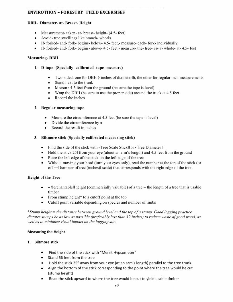
________________________________________________________________________________ENVIROTHON–FORESTRYFIELDEXCERSISES
DBH- Diameter- at- Breast- Height
Measurement- taken- at- breast- height- (4.5- feet) Avoid- tree swellings like branch- whorls If- forked- and- fork- begins- below- 4.5- feet,- measure- each- fork- individually If- forked- and- fork- begins- above- 4.5- feet,- measure- the- tree- as- a- whole- at- 4.5- feet
Measuring- DBH
1. D-tape- (Specially- calibrated- tape- measure)
Two-sided: one for DBH ( inches of diameter ), the other for regular inch measurements Stand next to the trunk Measure 4.5 feet from the ground (be sure the tape is level) Wrap the DBH (be sure to use the proper side) around the truck at 4.5 feet Record the inches
2. Regular measuring tape
Measure the circumference at 4.5 feet (be sure the tape is level) Divide the circumference by π Record the result in inches
3. Biltmore stick (Specially calibrated measuring stick)
Find the side of the stick with Tree Scale Stick or Tree Diameter Hold the stick 25ǁ from your eye (about an arm‘s length) and 4.5 feet from the ground Place the left edge of the stick on the left edge of the tree Without moving your head (turn your eyes only), read the number at the top of the stick (or off ―Diameter of tree (inches)ǁ scale) that corresponds with the right edge of the tree
Height of the Tree
erchantable height (commercially valuable) of a tree = the length of a tree that is usable timber From stump height* to a cutoff point at the top Cutoff point variable depending on species and number of limbs
*Stump height = the distance between ground level and the top of a stump. Good logging practice dictates stumps be as low as possible (preferably less than 12 inches) to reduce waste of good wood, as well as to minimize visual impact on the logging site.
MeasuringtheHeight
1.Biltmorestick
Findthesideofthestickwith“MerritHypsometer”Stand66feetfromthetreeHoldthestick25”awayfromyoureye(atanarm’slength)paralleltothetreetrunkAlignthebottomofthestickcorrespondingtothepointwherethetreewouldbecut(stumpheight)Readthestickupwardtowherethetreewouldbecuttoyieldusabletimber
28

Recordthenumbertothenearesthalflog(iftherearetwoseparatescalesonthehypsometer,besuretoreadoff“Qty16ft.logs@1Chain(66ft)distance”)Biltmoresticksmeasurestheheightofthetreeintermsofthenumberof16-footlogsToconverttheheighttofeet,multiplenumberby16
2.Clinometer
Stand a convenient distance from the tree, allowing a view of the tree‘s top and the bottom (Distance does not have to be 66 feet ) Be sure to stand on level ground as the tree Record your horizontal distance from the base of the tree Look through the viewer and find the red horizontal line (if you don‘t see anything, turn it upside down) Keeping BOTH eyes open, align the red line with the top of the tree (this may take a few seconds for your eyes to adjust)
Read the scale on the RIGHT (% scale) and record the number. This is you‘re A (+) reading in % Align the red line with the bottom of the tree Read the scale again. This is your B (-) reading in % Subtract the B from the A Multiply the % from above by the distance from the tree To get the number of 16-ft logs, divide the height in feet by 16
Example: A (+) = 63% B (-) = - 7% Distance from tree = 66‟ A – B = 63 – (-7) = 70%
70% x 66‟ = 46.2‟
A – B = 63 – (-7) = 70% 70% x 66‟ = 46.2‟
Tree volume Board feet = unit of tree volume used to estimate available lumber from a particular tree One board foot = a slab of wood, one foot wide x one foot long x one inch thick
Calculating volume in terms of board feet Measure the height of the tree in feet Measure the diameter of the tree in diameter Calculate the radius of the tree from the diameter (radius = diameter / 2) Convert the radius into feet (radius in inches / 12 = radius in feet) Find the area of the tree cross-section at breast height (4.5 ft) assuming the tree is a perfect circle (Area =radius x π) Calculate the volume of the tree (Area in feet x height in feet) Divide the volume by 4 to account for the taper of the tree Multiple the adjusted volume by 12 (there are 12 board feet of lumber for every on cubic foot) The final number is the number of board feet of lumber
Area of the tree cross-section = 12 x 3.14 = 3.14 ft2
Volume in ft3 = 3.14 x 40 = 125.6 ft3
Volume adjustment = 125.6 / 4 = 31.4 ft3 Volume in board feet = 31.4 x 12 = 378.6 board feet
Example: Height of the tree = 40 feet Diameter of the tree = 24 inches ( ) 2 12 24 ( ) x inches Radius feet = = 1 ft
29
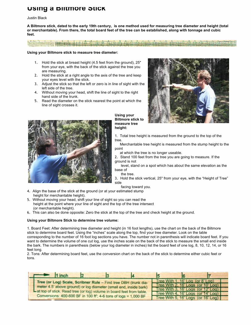
Using a Biltmore Stick
Justin Black
A Biltmore stick, dated to the early 19th century, is one method used for measuring tree diameter and height (total or merchantable). From there, the total board feet of the tree can be established, along with tonnage and cubic feet.
Using your Biltmore stick to measure tree diameter:
1. Hold the stick at breast height (4.5 feet from the ground), 25" from your eye, with the back of the stick against the tree you are measuring.
2. Hold the stick at a right angle to the axis of the tree and keep your eyes level with the stick.
3. Adjust the stick so that the left or zero is in line of sight with the left side of the tree.
4. Without moving your head, shift the line of sight to the right hand side of the trunk.
5. Read the diameter on the stick nearest the point at which the line of sight crosses it.
Using your Biltmore stick to measure tree height:
1. Total tree height is measured from the ground to the top of the tree. Merchantable tree height is measured from the stump height to the point at which the tree is no longer useable. 2. Stand 100 feet from the tree you are going to measure. If the ground is not level, stand on a spot which has about the same elevation as the base of the tree. 3. Hold the stick vertical, 25" from your eye, with the “Height of Tree” side facing toward you.
4. Align the base of the stick at the ground (or at your estimated stump height for merchantable height). 5. Without moving your head, shift your line of sight so you can read the height at the point where your line of sight and the top of the tree intersect (or merchantable height). 6. This can also be done opposite: Zero the stick at the top of the tree and check height at the ground.
Using your Biltmore Stick to determine tree volume:
1. Board Feet: After determining tree diameter and height (in 16 foot lengths), use the chart on the back of the Biltmore stick to determine board feet. Using the “inches” scale along the top, find your tree diameter. Look on the table corresponding to the number of 16 foot log sections you have. The number not in parenthesis will indicate board feet. If you want to determine the volume of one cut log, use the inches scale on the back of the stick to measure the small end inside the bark. The numbers in parenthesis (below your log diameter in inches) list the board feet of one log, 8, 10, 12, 14, or 16 feet long. 2. Tons: After determining board feet, use the conversion chart on the back of the stick to determine either cubic feet or tons.

Credit: Adapted from NYC Envirothon Study Guide
30
Forestry Worksheet DBHusingd-tape(inches)
DBHusingBiltmorestick(inches)
Circumference(inches)
Calculateddiameter(inches)
Measuringtheheightofatree
HeightusingBiltmorein16-ft
logs
Calculatedheightinfeet
Usingaclinometer ClinometerreadingA(+)
Clinometerreading
B(-)
A–Bin%
Calculatedheightinfeet
TreeVolumeCalculation
Heightofthetreeinfeet
Diameterofthetreeinfeet
Radiusofthetreeinfeet
Volumewithadjustment(AreaxHeightx¼)
VolumeinBoardFeet(multiplyby12)
What Does a Forester Do? A forester's job profile covers everything from the creation of original Timber Harvest Plans (THPs) to the protection of natural resources and enforcement of forestry laws.
Foresters can also specialize in certain specific areas that harness their expertise. Timber foresting and conservation foresting are a couple of the most common areas of specialization for foresters. Timber foresters work for the timber companies. This means that they look after the farms and forests privately owned by the timber companies. Their job responsibility includes taking final call on harvesting trees, monitoring ecological impact of harvesting timber, determining whether to approve a Timber Harvest Plan (THP), keeping track of yields and marking trees for harvest.
On the other hand, the conservation foresters generally tend to focus a lot more on global ecosystems and proper watershed preservation in the forested regions. The primary job responsibilities of the conservation foresters cover conducting periodic survey of regional animals and plants and keeping track of human activity in the forests. Conservation foresters might work as timber foresters at times and support timber harvesting. However, their top priority is always to try and create sufficient protected areas in the forests so that visitors can freely enjoy nature.
A forester may have an office of their own but in general they have to spend most of their time in remote outdoor places. This always leads them to challenging locations and sometimes they have to deal with turbulent weather conditions. Understandably, the job profile of a forester is physically demanding and requires sincere hard work and dedication as woodlands in most cases are difficult to access and it can take several hours to reach work sites.
Foresters who spend a lot of time in the forest generally work for longer periods and take some days off in between work periods. On the other hand, the conservation foresters working for state and federal agencies work around 40 hours every week though hours may not always be fixed like that of the normal nine to five working schedule. In times of natural calamities, forest fires and similar emergencies, foresters might have to work extra hours to bring the situation under control.
31

Soils and Land Use INTRODUCTION:
2015 Envirothon Soil Station
There can be many uses of the word "soil", depending upon the context. For example, soil can be thought of as an engineering material for road construction, as dirt on clothing, as a mixture of ingredients for growing potted plants, or what the farmers plow every spring.
For the purposes of the regional Envirothon, "Soil is the collection of natural bodies on the earth's surface, in places modified or even made by man of earthy materials, containing living matter and supporting or capable of supporting plants out-of-doors." Soil is thus considered both a product of nature and a critical part of natural systems. This definition also allows soils to be collectively grouped into a classification system, as used in making soil surveys.
Soils "begin" as parent material, and then the process of weathering occurs. Weathering eventually causes a differentiation into distinct horizons. A soil and its profile show the effects of five soil forming factors: Climate, Living Organisms, and Topographic Relief, Parent material and Time (it may help to remembe the d CLORPT"). Soils can be considered a youn , "mature" or "old", depending upon their extent of weathering and horizon development. Soils in NY State are relatively young or mature, but not old - their parent material was exposed or deposited during the relatively recent retreat of glaciers, some 10 to 15 thousand years ago
There are a number of soil properties and limitations including: composition, texture, structure, slope, color, chemistry, profile, permeability and drainage. In addition to defining and applying
32

these soil properties for background, a practical knowledge of the soils can be attained by using the Soil Survey, which classifies soils into series for identification, provides reference maps and interpretative tables.
Most of the soils in the U.S. are aerobic. But soils can often become saturated with water due to rainfall and flooding. When this anaerobic (no oxygen) environment continues for long periods during the growing season, different biological and chemical reactions begin to dominate. In soils where saturation with water is prolonged and is repeated for many years, unique soil properties usually develop. Soils with these unique properties are called hydric soils. These soils are important favor the formation of many types of wetlands. In fact, hydric soils were defined so that they help identify wetlands.
Soil erosion and sedimentation are separate processes, but think of them as occurring together, since once soil is eroded, it will eventually become sediment impacting water quality somewhere else. ³Normally it takes an average of 500 years for nature to build up 1 inch of topsoil. To grow good crops agriculturally, 6 inches of topsoil are required. Since only 1/500th of an inch of topsoil is being built up naturally on the average annually in the U.S., soil is being depleted on the average each year approximately 18 times faster than it is being built up in nature.² (Ecology Action, 5798 Ridgewood Road, Willits, CA 95490)
Source: New York State Envirothon Web Site
33

______________________________________________________________________________
ENVIROTHON:SOILS/LANDUSELEARNINGOBJECTIVES
For successful completion of the soils/ land use section, contestants should be able to:
Know the five soil forming factors, and understand how they influence soil properties.
Understand the origin and types of soil parent materials and land forms.
Understand basic soil forming processes: additions, losses, translocations, and transformations.
Recognize and understand features of Soil Profiles, and be able to use this information to determine basic soil properties and limitations.
Identify and describe soil characteristics (texture, structure, and color using Munsell color charts).
Understand soil biological diversity and how it relates to soil health and hence plant, human and environmental health. Recognize that understanding soil ecosystems is important to soil management.
Understand how the hydrologic, carbon and nutrient cycles relate to soil management.
Understand that soil fertility relates to the physical and chemical properties of the soil in addition to the quantity of nutrients.
Understand why soil fertility reflects the physical, chemical and biological state of the soil.
Compare different land uses and conservation practices and their impact on soils and erosion.
Understand how soil is impacted by point & non-point source pollution and practices used to address, reduce or eliminate the impact.
Access and use published and on-line soil data and other resources to learn how land use affects soil, and the limitations of local soils.
Understand Land Capability Classes and how they are important in determining appropriate land use.
Understand soil drainage classes and be able to recognize the characteristics of hydric soils.
34

ENVIROTHON:SOILS/LANDUSE OUTLINE
Soil: What is it?
Definition Development
1) parent material 2) processes of development 3) land forms
Characteristics
Composition Texture Structure Slope Color Chemistry Horizons/Profile Permeability/Percolation
I. Soil Water and Drainage
Soil Interpretations (Know how to use this information)
Agriculture Forestry Development USDA Land Use Classification
prime soils
Erosion & Sedimentation
Definitions Types of erosion Economic impacts Prevention
Principles agricultural conservation
practices nonagricultural
conservation practices
Hydric Soils
Definition Characteristics Uses/Limitations Economic Value
Soil Surveys (Know how to use this information)
Soil Series
what are they how to use them
35
ENVIROTHON:SOILS/LANDSKILLS_________________________________________________________
Use of clinometers, augers, color charts, test kits, and meters
Familiarity with soil pits
Determination of soil type by ribboning or use of particle screens
Basic ability to determine land use class
Identification of wetland indicators
Identify landform at site
Determine permeability of soil
Identify drainage class, depth to bedrock, depth of rooting
Measure thickness of topsoil, subsoil
Analyze soil structure and texture
Ability to quickly and effectively locate needed information in a soil survey
Using soil survey: identify hydrologic soil group; analyze chemical properties of soil; estimate erosion potential; Identify soil-mapping unit; evaluate soil type for its suitability for crops and pasture, woodland productivity, wildlife habitat, recreation, building site development and sanitary facilities.
Using the web-soil survey, learn the limitations that local soils have for septic systems, foundations, agriculture, and future development.
14. Determine soil characteristics and properties by describing soil horizons from a soil test pit.
36
ENVIROTHON:SKILLS-SAMPLEQUESTIONS
Soils Terminology and General Soils Knowledge:
A soil developed in "glacial outwash" refers to its:
Moisture condition Temperature classification Parent material None of the above
What size might a single sand particle be?
3 millimeters 3 centimeters .03 millimeters
Which of the following sentences makes the most sense?
The consistence of the soil is friable. The consistence of the soil is subangular blocky. The consistence of the soil is silt loam.
Sample questions in the Soil Pit
1. One of the most important soil characteristics affecting plant growth is the rooting zone of the topsoil. What is the depth of topsoil in the soil pit?
a. b. c. d.
0 to 2 inches 2 to 4 inches 4 to 10 inches 10 to 15 inches
2. Structure of the soil directly affects the ability of a plant to move and filter water throughout the soil. What is the structure of the surface horizon in the soil pit?
a. b. c. d.
Massive Single grained Blocky Granular
3. The solum is the upper part of the soil profile, (above the C horizon), in which the processes of soil formation are active. What is the depth of the solum in the pit?
a. 0 to 10 inches
37

b. c. d.
10 to 20 inches 20 to 30 inches Greater than 30 inches or below bottom of the pit
4. What is the surface texture of the soil in the pit?
a. b. c. d.
Clay Sandy loam Silty clay Silt loam
5. What is the structure of the soil in the pit between 10 to 20 inches?
a. b. c. d.
Blocky Prismatic Granular Single-grained
6. Redoximorphic depletions (gray mottles) are used to indicate the presence of a water table. At what depth do redoximorphic depletions occur in the soil pit?
a. b. c. d.
0 to 10 inches 10 to 20 inches 20 to 30 inches Greater than 30 inches or below the bottom of the pit
7. What is the texture class of the soil in the pit between 10 to 20 inches?
a. b. c. d.
Silt loam Sandy loam Sandy clay Silty clay
8. Soil texture affects the ability of a soil to hold and release nutrients, which is critical in the development of sustainable local agriculture. What is the texture of the topsoil?
a. b. c. d.
Clay Sandy Clay Loam Silt Loam
9. Topsoil is a critical element in reducing erosion, nutrient runoff, and is also important in sustainable agriculture. What is the depth of topsoil in the soil pit?
a. b. c. d.
0 to 4 inches 4 to 8 inches
8 to 12 inches 12 to 16 inches
38

10. Structure of the soil directly affects the ability of soil to move and filter water. What is the structure of the topsoil in the soil pit?
a. Massive b. Single grained c. Blocky d. Granular
Use of Soil Survey Reports:
Web Soil Survey (WSS) provides soil data and information produced by the National Cooperative Soil Survey. It is operated by the USDA Natural Resources Conservation Service (NRCS) and provides access to the largest natural resource information system in the world. NRCS has soil maps and data available online for more than 95 percent of the nation‘s counties and anticipates having 100 percent in the near future. The site is updated and maintained online as the single authoritative source of soil survey information.
Soil surveys can be used for general farm, local, and wider area planning. Onsite investigation is needed in some cases, such as soil quality assessments and certain conservation and engineering applications. For more detailed information, contact your local USDA Service Center or your NRCS State Soil Scientist.
http://websoilsurvey.nrcs.usda.gov/app/
Learning Objectives: 1. Access and use published and on-line soil data and other resources to learn how land use affects soil, and the limitations of local soils.
2. Understand the eight Land Capability Classes and how they are important in determining appropriate land use.
3. Understand soil drainage classes and be able to recognize the characteristics of hydric soils and know how soils fit into the definition of wetlands.
Suggested Activities:
1. Download your local area‘s soil survey map to learn the limitations that local soils have for septic systems, foundations, agriculture, and future development.
2. Describe the eight Land Capability Classes and use a soil profile and site description to determine land capability class.
3. Visit your local land planning office and ask how GIS and GPS systems are used in making land use planning and development decisions. Explain how GIS and GPS can be used in learning about the soil characteristics in a wetland soil.
39

ENVIROTHON:SOILSKILLS–TRUEORFALSE?
1. Available water holding capacity is the amount of water that a soil can store and release to plant roots?
2. The physical condition of a soil as related to its ease of tillage, fitness as a seedbed and impedance to seedling emergence and root penetration is called tilth?.
3. Calcium is a soil macronutrient?
4. In a pine stand, the soil pH is generally acidic?
5. All soils will produce trees of commercial value?
6. Terrace soils refer to those soils formed in old alluvial sediments?
7. Potassium is an essential plant nutrient that is the most easily leached from the soil?
8. The presence of mottles in a soil profile indicates impeded soil drainage?
9. You would expect a soil classified as montmorillonitic to have high organic matter?
10. Munsell soil color notations are comprised of hue, value, and chroma?
11. Generally the deeper the soil, the greater the site index?
12. A field is made up of only one type of soil?
13. If harvesting were taking place, clayey soils would compact the most under normal harvest operations?
14. Soils high in coarse fragments are harder to compact than fragment free soils?
15. Wind may move soil particles by abrasion?
16. If a soil profile exhibits relatively thin layers of light and dark colored materials stratified approximately parallel to the surface, it is likely that the soil is located on a floodplain?
40
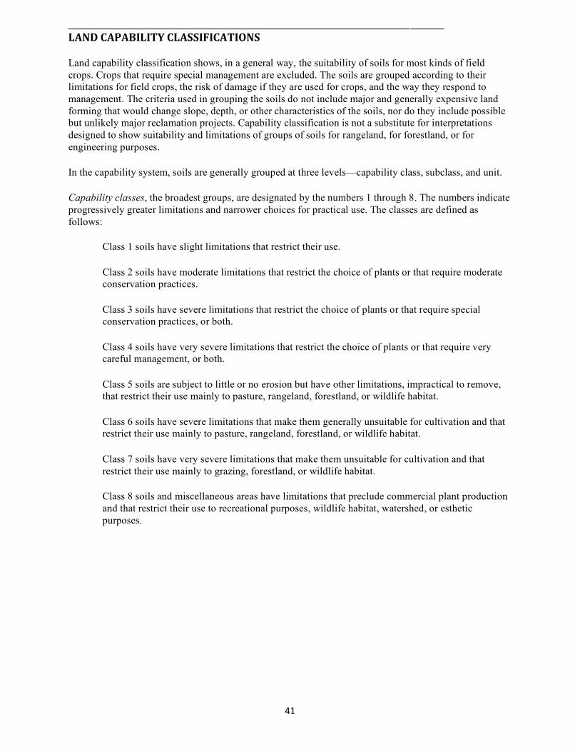
LANDCAPABILITYCLASSIFICATIONS
Land capability classification shows, in a general way, the suitability of soils for most kinds of field crops. Crops that require special management are excluded. The soils are grouped according to their limitations for field crops, the risk of damage if they are used for crops, and the way they respond to management. The criteria used in grouping the soils do not include major and generally expensive land forming that would change slope, depth, or other characteristics of the soils, nor do they include possible but unlikely major reclamation projects. Capability classification is not a substitute for interpretations designed to show suitability and limitations of groups of soils for rangeland, for forestland, or for engineering purposes.
In the capability system, soils are generally grouped at three levels—capability class, subclass, and unit.
Capability classes, the broadest groups, are designated by the numbers 1 through 8. The numbers indicate progressively greater limitations and narrower choices for practical use. The classes are defined as follows:
Class 1 soils have slight limitations that restrict their use.
Class 2 soils have moderate limitations that restrict the choice of plants or that require moderate conservation practices.
Class 3 soils have severe limitations that restrict the choice of plants or that require special conservation practices, or both.
Class 4 soils have very severe limitations that restrict the choice of plants or that require very careful management, or both.
Class 5 soils are subject to little or no erosion but have other limitations, impractical to remove, that restrict their use mainly to pasture, rangeland, forestland, or wildlife habitat.
Class 6 soils have severe limitations that make them generally unsuitable for cultivation and that restrict their use mainly to pasture, rangeland, forestland, or wildlife habitat.
Class 7 soils have very severe limitations that make them unsuitable for cultivation and that restrict their use mainly to grazing, forestland, or wildlife habitat.
Class 8 soils and miscellaneous areas have limitations that preclude commercial plant production and that restrict their use to recreational purposes, wildlife habitat, watershed, or esthetic purposes.
41

ENVIROTHON:SOILS/LANDUSE-RECOMMENDEDRESOURCES
Soil Hydric Soils
From The Surface Down, 4H Soil Handbook, Soil Biology, Soil Biodiversity, Intro to Soil Quality
Field Indicators, Hydric Soils
WEBSITES
Characteristics USDA-NRCS Soils A site for "Helping People Understand Soils." Master Horizons & Layers, Keys to
Soil Taxonomy, Soil Formation and Classification, Soil Compaction, Soil Carbon & Nitrogen, Soil Water, Soil Glue, Soil Structure & Macropores, Assessing Soil Quality, Infiltration, Indicate, Aggregate Stability, Organic Matter, Soil Crusts
Agronomy Fact Sheets
Soil and Water Conservation Society National Science & Technology LEFT Soil Biological Communities
Web Soil Survey (allows online viewing of soil survey maps and reports. This new application greatly enhances access to information on soils.)
Soil Surveys
Urban Soils Primer, How to use a Soil Survey Soil Data Mart (determine if spatial
and/or tabular data of soil survey is available for specific county for viewing in ArcGIS)
Soil Interpretations
Water Quality and Agriculture, Soil Biology & Land Management Demonstrations in Soil Science The
experiments listed in the "demonstrations" reference are not expected by the students, but they should be familiar with the principals behind each experiment and the soils properties that the experiments are demonstrating.
Erosion & Sedimentation
Building Soils for Better Crops, Understanding Soil Risks & Hazards, Soil Quality Resource Concern-Soil Erosion, Conservation Crop Rotation, Erosion On Construction Sites, Soil Quality Resource Concern-Soil Erosion, Managing Soil Organic Matter, Effects of Soil Erosion
12 Soil Orders
Soil Quality Resource Concerns: Soil Erosion
42

ENVIROTHON:SOILS/LANDUSE–GLOSSARY
E
Acre: A unit of measurement of land. It is equal to the area of land inside a square that is about 209 feet on each side (43,560 square feet).
Eluviation:The movement of material in true solution of colloidal suspension from one place to another within the soil. Soil horizons that have lost material through eluviation are eluvial; those that have received material are illuvial.
B
Bacteria: Microscopic organisms that live on water and on land. They help break down organic materials into simpler nutrients in a process called decay. Bacteria release nutrients to the soil.
Evaporation: Changing a liquid to a gas; for example, when water turns into steam or water vapor.
F Bedrock:A more or less solid layer of rock found on the surface of the land or below the soil.
Fungi (plural of fungus): A group of non- green plants, such as molds, and mushrooms, that live on dead or dying organic matter. Fungi release nutrients to the soil.
Complex, Soil:A map unit of two or more kinds of soil in such an intricate pattern or so small in area that it is not practical to map them separately at the selected scale of mapping. The pattern and proportion of the soils are somewhat similar in all areas.
H
Humus:Highly decomposed plant and animal residue that is a part of soil.
Hydrologic Cycle:The cycle of water movement from the atmosphere to the earth and back again through these steps; evaporation, transpiration, condensation, precipitation, percolation, runoff and storage.
Contour Stripcropping: Growing crops in strips that follow the contour. Strip of grass or close-growing crops are alternated with strip of clean-tilled crops or summer fallow.
L
Drainage Class:Refers to the frequency and duration of periods of saturation or partial saturation during soil formation, as opposed to altered drainage, which is commonly the result of artificial drainage or irrigation but may be caused by the sudden deepening of channels or the blocking of drainage outlets.
Llluviation:The movement of soil material from one horizon to another in the soil profile. Generally, material is removed from an upper horizon and deposited in a lower horizon.
Leaching: The removal of soluble minerals from soil by the downward movement of water.
43

Percolation: The downward movement of water in soil.
M Permeability: The quality of soil that allows air or water to move through it. Mineral: A naturally occurring inorganic
substance with definite chemical and physical properties and a definite crystal structure.
pH Value: A numerical designation of acidity and alkalinity in soil. (See Reaction, soil)
Mottling, soil:irregular spots of different colors that vary in number and size. Mottling generally indicates poor aeration and impeded drainage.
Pore Spaces: The area of the soil through which water and air move. The space between soil particles.
Munsell Notation:A designation of color by degrees of three simple variables hue. value, and chroma. For example, a notation of 10YR 6/4 is a color with hue of 10YR, value of 6, and Chroma of 4.
Precipitation: Rain, snow, and other forms of water that fall to earth.
Reaction, Soil: A measure of acidity or alkalinity of a soil. expressed in pH -values. A soil that tests to pH 7.0 is described as precisely neutral in reaction because it is neither acid nor alkaline.
Nematodes: Microscopic, elongated worms that live on other organisms in the soil.
Regolith: The unconsolidated mantle of weathered rock and soil material on the earth's surface; the loose earth material above the solid rock. Rock Fragments: Rock or mineral fragments having a diameter of 2 millimeters or more; for example, pebbles, cobbles, stones, and boulders.
Nutrient: A substance that supplies nourishment for an organism to live. It can be food or chemical depending upon the organism.
Nutrient Exchange: The process by which plant roots exchange an acid for nutrients from the soil. Root Zone: The part of the soil that can be
penetrated by plant roots. Runoff: Water that flows off land into streams and other waterways.
O
Organic Matter: Plant and animal material in various stages of decomposition that may be part of the soil.
Sand: As a soil separate, individual rock or mineral fragments from 0.05 millimeter to 2.0 millimeters in diameter. Most sand grains consist of quartz. As a soil textural class, a soil that is 85% or more sand and not more than 10% clay.
P
Parent Material: The earthy materials both mineral and organic-from which soil is formed.
44

Subsurface Layer: Any surface soil horizon (A, E, AB, or EB) below the surface layer.
Silt: As a soil separate, individual mineral particles that range in diameter from the upper limit of clay (0.002 mm) to the lower limit of very fine sand (0.05 mm). As soil textural class, soil that is 80% or more silt and less than 12% clay.
Surface Layer: The soil ordinarily moved in tillage, or its equivalent in uncultivated soil, ranging in depth from about 4 to 10 inches (10 to 25 centimeters). Frequently designated as the plow layer, or the Ap horizon.
Soil: A naturally occurring mixture of minerals, organic matter, water and air which has definite structure and composition and forms on the surface of the land.
Soil Color: The color of a sample of soil T
Soil Horizon: A layer of soil that is nearly parallel to the land surface and is different from layers above and below.
Top soil: The upper part of the soil, which is the most favorable material for plant growth. It is ordinarily rich in organic matter and is used to top dress road banks, lawns, and land affected by mining. Z
Soil Mineral: That portion of the soil that is inorganic and neither air nor water.
Soil Survey: The identification, classification, mapping interpretation and explanation of the soil. Zone of Accumulation: The layer in a soil
into which soluble compounds are moved and deposited by water. Zone of Decomposition: Surface layers in a soil in which organic matter decays.
Soil Texture: The relative amounts of sand, sift, and clay in a given soil sample.
Subsoil: Technically, the B horizon; roughly, the part of the solum below plow depth. Zone of Leaching: The layers in a soil from
which soluble nutrients are removed by water.
Substratum: The part of the soil below the solum.
45

ENVIROTHON:SOILS/LANDUSE–SOILPRINCIPALSDeveloped by a soil scientist, this guide provides a framework of principal soils topics. It may help to organize your knowledge into categories such as these while preparing for the contest.
I. SOIL CONCEPTS
A. Definition of soil - There can be many uses of the word "soil", depending upon the context. For example, soil can be thought of as an engineering material for road construction, as dirt on clothing, as a mixture of ingredients for growing potted plants, or what the farmers plow every spring. For the purposes of the Envirothon, "soil" is defined as it is in the textbook (Soil Science Simplified, 1997): "Soil is the collection of natural bodies on the earth's surface, in places modified or even made by man of earthy materials, containing living matter and supporting or capable of supporting plants out-of-doors." Soil is thus considered both a product of nature and a critical part of natural systems. This definition also allows soils to be collectively grouped into a classification system, as used in making soil surveys.
B. Soil development - a process that occurs over time.
Soils "begin" as parent material, and then the process of weathering occurs. Weathering eventually causes a differentiation into distinct horizons. A soil and its profile show the effects of five soil-forming factors: Climate, Living
Organisms,
Topographic Relief, Parent material and Time (it may help to remember the word "CLORPT"). Soils can be considered as "young", "mature" or "old", depending upon their extent of weathering and horizon development. Soils in NY State are relatively young or mature, but not old - their parent material was exposed or deposited during the relatively recent retreat of glaciers, some 10 to 15 thousand years ago.
II. SOIL CHARACTERISTICS
A. Composition - About a 50%-50% mix of solids and open space; voids may hold water or air.
B. Texture - refers to soil particle size, sand = 2 to 0.05 mm; silt = 0.05 to 0.002 mm; clay = < 0.002 mm. Soil texture influences water storage & movement, fertility, and workability or "tilth". c "Loam" is a name for one of various mixtures of these three particle sizes.
C. Structure - the arrangement of soil particles into aggregates, which may have various shapes, sizes and degrees of development or expression. Soil structure influences aeration, water movement, erosion resistance, and root penetration.
D. Slope - the inclination of the ground surface. Slope influences runoff of rainfall, soil erosion, stability, and machinery operation.
E. Color - Soil color often indicates soil moisture status and is used for determining hydric soils. Often described using general terms, such as dark brown, yellowish brown, etc., soil colors are also described more technically by using Munsell soil color charts, which separate color into components of hue (relation to red, yellow and blue), value (lightness or darkness) and chroma (paleness or strength).
46

F. Chemistry - A complex subject within soil science; the most important subjects are: pH - The acidity or alkalinity of soils, which affects plant growth and soil fertility.
G. The soil profile - A vertical cut that exposes soil layering or horizons are formed by combined biological, chemical and physical alterations. A, B, and C symbols are used to describe the topsoil, subsoil and substratum, respectively.
H. Permeability - The ability of a soil to transmit water or air. Faster or greater permeability often occurs in sandy or gravelly soils due to large pore spaces. Slower permeability typically occurs in finer textured clay soils, or compacted soils with little structure.
I. Drainage - The rate in which water is removed from a soil. Drainage influences most uses of soils, whether for agriculture, silviculture or urban. Classes of soil drainage are those found in soil survey reports, such as well drained, moderately well drained, somewhat poorly drained, poorly drained, and very poorly drained. Soil color patterns (such as mottle patterns or redoximorphic features) often indicate soil drainage class. Most productive agricultural soils in NY are well drained or moderately well drained. By contrast, hydric soils are poorly or very poorly drained. A soil's natural drainage rate can be significantly increased by subsurface "tile" drainage.
III. SOIL SURVEY MAPS
A. Soil Series - A level of Soil Taxonomy, the soil classification system used in making soil surveys. One example is the "Mardin Series".
IV. SOIL SURVEY INTERPRETATIONS
Become familiar with the interpretive tables within a relatively modern soil survey (since about 1970). These commonly include soil suitability for uses such as:
A. Agriculture
V. EROSION AND SEDIMENTATION
These are separate processes, but think of them as occurring together, since once soil is eroded it will eventually become sediment somewhere. A. Erosion is the "wearing away" of land by the action of water, wind or ice. It is a natural, geologic process, but often is greatly accelerated by man's activities.
VI. HYDRIC SOILS
A. Introduction Most of the soils in the U.S. are aerobic. This is important to our food, fiber and forest production because plant roots respire (that is, they consume oxygen and carbohydrates while releasing CO2) and there must be sufficient air - especially oxygen - in the soil to support root life. As mentioned in the textbook (Soil Science Simplified), air normally moves through interconnected pores by forces such as changes in atmospheric pressure, turbulent wind, the flushing action of rainwater, and by simple diffusion.
In addition to plant roots, most forms of soil microorganisms need oxygen to survive. This is true of the more well-known soil animals as well, such as ants, earthworms and moles. But soils can often become saturated with water due to rainfall and flooding. Air travels very slowly (some 10,000 times slower) when soil becomes saturated with water because there are no open passageways for air to travel. When oxygen levels become limited, intense competition arises between soil life forms for the remaining oxygen. When this anaerobic (no
47

oxygen) environment continues for long periods during the growing season (April to October in most of NY), quite different biological and chemical reactions begin to dominate, compared with aerobic soils. In soils where saturation with water is prolonged and is repeated for many years, unique soil properties usually develop that can be recognized in the field. Soils with these unique properties are called Hydric Soils, and although they may occupy a relatively small portion of the landscape, they maintain important functions in the environment.
B. Why are hydric soils important? The environmental conditions that create hydric soils (water remaining at or near the soil surface for extended time periods during the growing season) also favor the formation of many types of wetlands.
Wetlands play important roles in the environment, some of which we have only begun to understand and appreciate. Groundwater is recharged or restored by entering some wetlands; however, in New York soils it is probably just as common that groundwater discharges (exits) to become surface water through wetlands. During periods of heavy rains or melting snow, flooding can present a real danger to people and property; but because wetlands occupy depressions in the landscape they can trap and thereby detain flood waters, thus reducing downstream damages. Wetlands are often difficult places for humans to physically move around in, so most people avoid them; this is one reason that they provide critical habitat for many rare and endangered species of flora and fauna. Because wetlands often occur in relatively low elevations, they commonly receive polluted waters from man's activities on higher, drier ground; wetlands can effectively filter these waters and retain excess nutrients. Wetlands are also valuable for recreation, including nature appreciation, hunting, fishing, canoeing, etc.
Due to historical and present development pressures, the number and extent of wetlands has been greatly diminished (by about 50%) in the United States since the time when the first white settlers arrived. Within the last 10 to 20 years, political debates and new regulations have focused on methods to conserve and rehabilitate wetlands. Because they are formed in association with wetlands, hydric soils can be used to identify the presence and boundaries of wetlands. In fact, hydric soils were defined so that they help identify wetlands. Along with unique vegetation and hydrology, hydric soils are one of the three required indicators for wetland identification. As a result, hydric soils are a very important issue in land management and land planning across the United States due to their role in the identification of wetlands and their function in wetland ecology.
C. Defining hydric soils various government agencies are involved with wetland protection. The NY State Department of Environmental Conservation (DEC) protects wetlands over 5 hectares (12.4 acres) in size. The US Department of Agriculture Natural Resources Conservation Service identifies and protects wetlands that have been used for agriculture. The US Army Corps of Engineers protects wetlands of practically any size. With the help of soil scientists, they have defined hydric soils, which they consider to be those soils which are developed under sufficiently wet conditions to support the growth and regeneration of hydrophytic vegetation: A hydric soil is a soil that is saturated, flooded, or ponded long enough during the growing season to develop anaerobic conditions in the upper part.
This definition can be broken up into three component parts:
1) The soil is saturated, flooded or ponded. Saturated conditions are often the result of a high water table. Flooded conditions are produced by overflowing streams, runoff from
48

higher surrounding slopes or from high tides that inundate coastal wetlands. Ponded conditions are produced by higher water inflow than water outflow from a closed depression.
2) Wet conditions occur during the growing season. This is the period of time when the soil is above 5oC or approximately 40oF. Above this temperature, biological activity is significant and many plants are able to grow.
3) The soil is wet long enough to develop anaerobic conditions in the upper part. The vast majority of soil biological activity occurs at or near the soil surface. When the soil is biologically active, a few weeks of wet conditions is usually adequate to use up available oxygen; however, this can be affected by many factors (e.g. soil and water temperature, the oxygen content of the water, soil organic matter content, soil permeability, etc.). The important thing is that anaerobic conditions result often or long enough to support mostly hydrophytic (water-loving) plants. Further, much of the biological activity in soils is engaged in the decomposition of organic matter either deposited within or on the soil surface. When oxygen is not available to the soil flora and fauna, biological activity is greatly reduced. As a result, organic material builds up in the soil. Additionally as a result of the wet, anaerobic environment the soil takes on a characteristic reducing condition and undergoes chemical reactions that are different than non-hydric soils.
D. Hydric soil properties and indicators the physical, chemical and biological properties which make hydric soils recognizable are the result of complex bio-geochemical processes occurring over many years.
Hydric soils usually have a water table, or the top of a zone of saturation, within one foot from the soil surface during the growing season. This shallow water table excludes oxygen and so creates a reducing environment, especially in the upper part of the soil profile. As a result, mostly hydrophytic plants proliferate - such as rushes, cattails, sedges and skunk cabbage.
Most soils, including hydric soils, are dominantly composed of minerals such as quartz, feldspars, clay minerals, etc. However, hydric soils commonly have a buildup of organic matter at the soil surface, for reasons described above, which can make the surface horizon dark, colored. If the organic matter content (measured as organic carbon) is greater than 20 to 30% of the soil's weight (depending upon clay content) and this organic-rich layer is over 16 inches thick, then it is considered an organic soil. Most soil organic matter originates as plant tissue, so organic soils are called Histosols (the Greek word for tissue is histose). Many types of organic soils exist, but they can be classified by their thickness and degree of decomposition (see chapter 12 of text). Peat, such as common "peat moss", is mostly composed of recognizable plant fragments that are only partly decomposed. Muck contains highly decomposed organic matter and, when drained of excess water and carefully managed, these black and spongy soils comprise some of the most important vegetable-producing soils in the eastern US. Another property unique to hydric soils is their color or color patterns. Besides the dark shading from the presence of organic matter, iron compounds are the most important coloring agents in soils. Hydric soils tend to exhibit gray or blue-gray colors (known as gleying or gleyed colors) especially just beneath the topsoil or surface horizon (see lower portion of photograph). This results from the chemically reduced oxidation state of iron compounds, as opposed to the rusty red (oxidized) and brown colors of drier, non-hydric soils. Where shallow water tables fluctuate, gray, yellow and red colors can also occur as small splotches, threadlike or network patterns, created by accumulations or depletions of iron and manganese (orange colors in photograph). Because they result from processes of reduction and oxidation these color indicators of wetness are collectively termed redoximorphic features.
Hydric Soils section written by Larry Day (Delaware County Soil and Water Conservation District) and Jonathan Russell-Anelli (c/o Dept. Soils, Crops and Atmospheric Sciences, Cornell University).
49

What do Soil Scientist Do? The earth's ecosystem relies on the soil as a foundation from which to build. Soil Scientists teach people what soil is and how it interacts with other components of our ecosystem. They study and research soil formation, classification and engage in soil mapping (i.e. soil surveys). They investigate the chemical and biological properties of soil and how these support life above ground. They also strive to find sustainable management and usage guidelines which will benefit crop production, environmental quality, waste management, recycling and wildlife.
Soil Scientists often work for the federal government but also find work with non-profit environmental groups, consulting firms or private practice. In the government sector, soil scientists can work for the Bureau of land Management (BlM), or a state's environmental agency. They work on comprehensive soil surveys and interact with the public offering tips on the best management practices for land use, plant growth and erosion control. Soil Scientists often act as consultants working with engineers on construction projects or technicians on soil problems, and often they deal with waste management and groundwater issues.
Soil Scientists spend much of their time outdoors, conducting soil testing and gathering information about the relationship between different soil properties and plant growth. Soil Scientists require at least a four year bachelor's degree from an accredited university, and usually a master's degree or higher to work in research positions. Students will study a range of disciplines including biology, geology, chemistry and hydrology. Recent graduates often make between $40,000 and $65,000 per year. Soil Science is integral to understanding the world we live in and to supporting the health of our ecological community. The demand for Soil Scientists will be steady as our nation strives to live in sustainable harmony with our environment.
Source: NYC Envirothon Resource Packet
References: National Envirothon www.envirothon.org/ NY State Envirothon www.nysenvirothon.net/
50

Notes
51

Wildlife INTRODUCTION
2015 Wildlife Station
Along with aquatics, forestry and soils, wildlife is another of our valuable natural resources. Wildlife are highly dependent upon the status of aquatic, forestry and soil ecology. Today, the greatest threat to wildlife is habitat loss. The impact of human land use practices on wildlife populations and their habitats is a major concern nation-wide.
At Envirothon the wildlife station will emphasize animal wildlife in New York State. Students will be expected to have a basic understanding of regional species populations and their habitats, how they function and change over time and their role in the ecosystem. They should be able to identify common wildlife species and their corresponding characteristics and habitats. In addition, the wildlife learner should develop an awareness and knowledge of the following: specific adaptations of wildlife to their environment; wildlife survival needs; predator/prey relationships; food chains and food webs; factors that limit or enhance population growth; concepts of carrying capacity and limiting factors; non-native species; threatened and endangered species; and the roles of both the public and wildlife managers in the protection, conservation, management, and enhancement of wildlife populations.
"Without knowing it, we utilize hundreds of products each day that owe their origin to wild animals and plants. Indeed our welfare is intimately tied up with the welfare of wildlife. Well may conservationists proclaim that by saving the lives of wild species, we may be saving our own."
52

ENVIROTHON:WILDLIFELEARNINGOBJECTIVES
For successful completion of the wildlife section, contestants should be able to:
Identify the mammal, bird, bird, amphibian and reptile species, insect and other species listed on the "Wildlife Species to Study" list using mounted specimens, skins/pelts, pictures, skulls, silhouettes, decoys, wings, feathers, scats, tracks, animal sounds, or other common signs
Identify general food habits , habitats, and habits from teeth and/or skull morphology
Know the preferred habitat types and specific habitat requirements of the above wildlife species and the factors that affect wildlife suitability
Know and understand basic ecological concepts and terminology including the difference between an ecosystem, community and population
Understand wildlife population dynamics and limiting and decimating factors of wildlife management
Be able to identify, describe and explain adaptations of wildlife to their environment
Understand the 3 levels of biodiversity and the implications of loss at each level
Identify common wildlife management practices and methods that are being used to manage and improve wildlife habitat
Understand the role of federal and state Fish and Wildlife Agencies in the management, conservation, protection, and enhancement of fish and wildlife and their habitats.
Be familiar with finding information found within the NYS hunting safety guide and hunter education program
Understand the environmental impact of invasive species, threat to biodiversity, and impact on native wildlife
Understand common land use decisions that affect wildlife population growth, environmental degradation, and habitat reduction
Be familiar with common wildlife diseases from microbes, parasites, toxins, and other biological and physical agents
Understand the terminology and factors that affect threatened and endangered wildlife species. Know examples of NYS species that are extinct, extirpated, endangered, threatened, and special concern
Understand the role of the Endangered Species Act in helping to conserve endangered and threatened species. Know the organizations and agencies responsible for listing and protecting endangered species on global, federal, and state levels
53
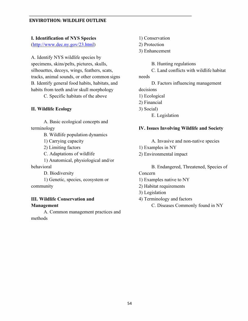
ENVIROTHON:WILDLIFEOUTLINE
Conservation Protection Enhancement
I. Identification of NYS Species (http://www.dec.ny.gov/23.html)
Identify NYS wildlife species by specimens, skins/pelts, pictures, skulls, silhouettes, decoys, wings, feathers, scats, tracks, animal sounds, or other common signs
Identify general food habits, habitats, and habits from teeth and/or skull morphology
Specific habitats of the above
B. Hunting regulations C. Land conflicts with wildlife habitat
needs D. Factors influencing management
decisions Ecological Financial Social)
E. Legislation II. Wildlife Ecology
Basic ecological concepts and terminology
Wildlife population dynamics Carrying capacity Limiting factors
C. Adaptations of wildlife 1) Anatomical, physiological and/or
behavioral D. Biodiversity 1) Genetic, species, ecosystem or
community
IV. Issues Involving Wildlife and Society
A. Invasive and non-native species Examples in NY Environmental impact
B. Endangered, Threatened, Species of Concern
Examples native to NY Habitat requirements Legislation Terminology and factors
C. Diseases Commonly found in NY Wildlife Conservation and
Management Common management practices and
methods
54
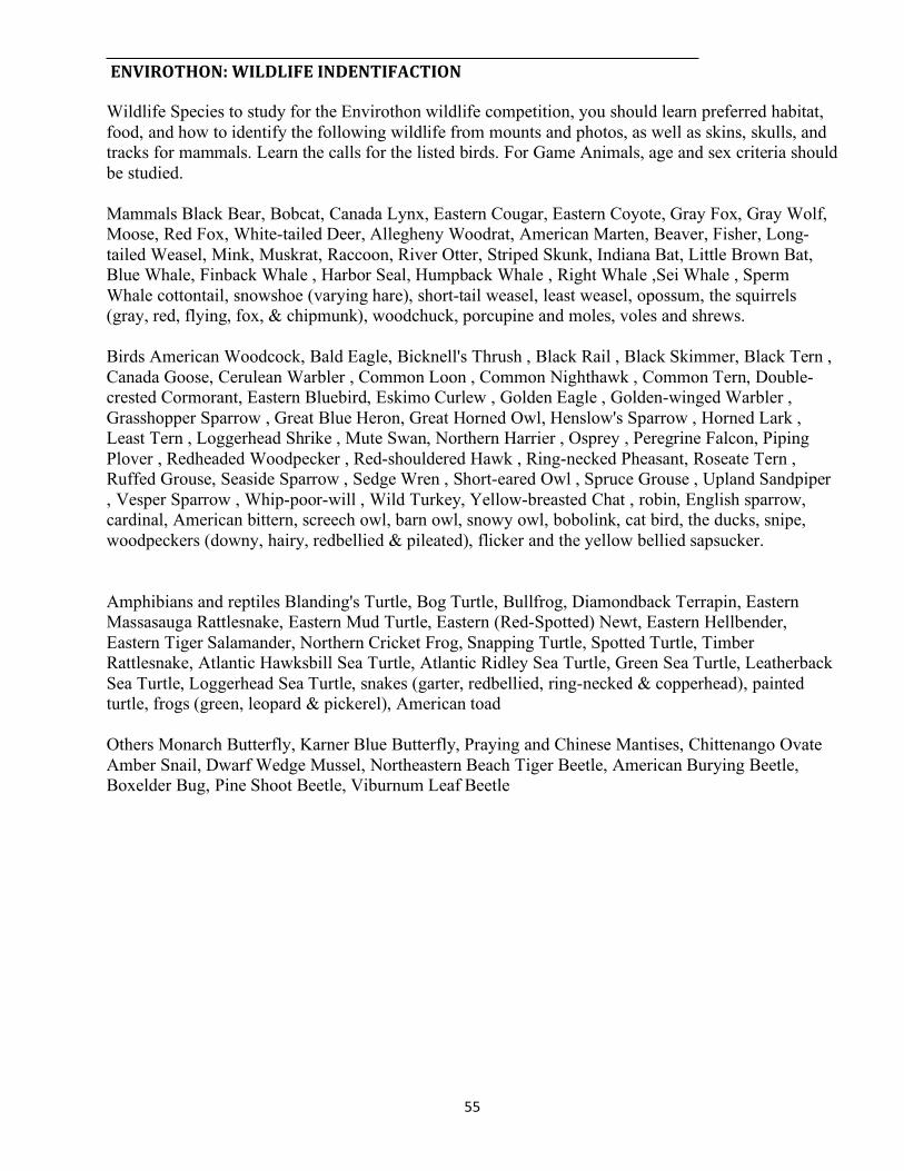
ENVIROTHON:WILDLIFEINDENTIFACTION
Wildlife Species to study for the Envirothon wildlife competition, you should learn preferred habitat, food, and how to identify the following wildlife from mounts and photos, as well as skins, skulls, and tracks for mammals. Learn the calls for the listed birds. For Game Animals, age and sex criteria should be studied.
Mammals Black Bear, Bobcat, Canada Lynx, Eastern Cougar, Eastern Coyote, Gray Fox, Gray Wolf, Moose, Red Fox, White-tailed Deer, Allegheny Woodrat, American Marten, Beaver, Fisher, Long- tailed Weasel, Mink, Muskrat, Raccoon, River Otter, Striped Skunk, Indiana Bat, Little Brown Bat, Blue Whale, Finback Whale , Harbor Seal, Humpback Whale , Right Whale ,Sei Whale , Sperm Whale cottontail, snowshoe (varying hare), short-tail weasel, least weasel, opossum, the squirrels (gray, red, flying, fox, & chipmunk), woodchuck, porcupine and moles, voles and shrews.
Birds American Woodcock, Bald Eagle, Bicknell's Thrush , Black Rail , Black Skimmer, Black Tern , Canada Goose, Cerulean Warbler , Common Loon , Common Nighthawk , Common Tern, Double- crested Cormorant, Eastern Bluebird, Eskimo Curlew , Golden Eagle , Golden-winged Warbler , Grasshopper Sparrow , Great Blue Heron, Great Horned Owl, Henslow's Sparrow , Horned Lark , Least Tern , Loggerhead Shrike , Mute Swan, Northern Harrier , Osprey , Peregrine Falcon, Piping Plover , Redheaded Woodpecker , Red-shouldered Hawk , Ring-necked Pheasant, Roseate Tern , Ruffed Grouse, Seaside Sparrow , Sedge Wren , Short-eared Owl , Spruce Grouse , Upland Sandpiper , Vesper Sparrow , Whip-poor-will , Wild Turkey, Yellow-breasted Chat , robin, English sparrow, cardinal, American bittern, screech owl, barn owl, snowy owl, bobolink, cat bird, the ducks, snipe, woodpeckers (downy, hairy, redbellied & pileated), flicker and the yellow bellied sapsucker.
Amphibians and reptiles Blanding's Turtle, Bog Turtle, Bullfrog, Diamondback Terrapin, Eastern Massasauga Rattlesnake, Eastern Mud Turtle, Eastern (Red-Spotted) Newt, Eastern Hellbender, Eastern Tiger Salamander, Northern Cricket Frog, Snapping Turtle, Spotted Turtle, Timber Rattlesnake, Atlantic Hawksbill Sea Turtle, Atlantic Ridley Sea Turtle, Green Sea Turtle, Leatherback Sea Turtle, Loggerhead Sea Turtle, snakes (garter, redbellied, ring-necked & copperhead), painted turtle, frogs (green, leopard & pickerel), American toad
Others Monarch Butterfly, Karner Blue Butterfly, Praying and Chinese Mantises, Chittenango Ovate Amber Snail, Dwarf Wedge Mussel, Northeastern Beach Tiger Beetle, American Burying Beetle, Boxelder Bug, Pine Shoot Beetle, Viburnum Leaf Beetle
55

ENVIROTHON:WILDLIFESAMPLEQUESTIONS
1. This song is being sung by what species of bird?
a. Cerulean Warbler b .Eastern Bluebird
Vesper Sparrow Mute Swan
2. Habitat is the place where an animal lives. It provides for the needs required by the animal to survive. The number of animals a habitat can support in good health is known as its
a. bionic potential b. harvestable surplus c. carrying capacity d. home range
3. Many of the wildlife species of New York live in a certain habitat because of their needs to survive or physical adaptations that help them live in the habitat. Least suited for a swamp/marsh habitat are .
Woodcocks Redwing Blackbirds Wood ducks Woodchucks
4. During the last century, human impacts on our planet have led to an increasing and alarming loss of biodiversity. Scientists estimate that current extinction rates exceed those of prehistoric mass extinctions. Loss of biodiversity also means loss of genetic diversity and loss of ecosystems. In New York State the major cause for declines in species populations is which of the following?
a. habitat destruction, alteration and fragmentation b. the spread of invasive species c. pollution d .illegal collection e. climate change
5. The following habitat management activities; 1) elimination of barriers that hinder migration between ponds and nest or hibernation sites, 2) placement of "turtle crossing" signs to warn motorists of the turtle's presence in key areas, and 3) maintenance of open areas for nesting, have been recommended to protect which species?
Eastern mud turtle Diamondback terrapin
56

c. Loggerhead sea turtle d. Bog turtle
6. Only the basic hunter education course is required to obtain a license to hunt waterfowl outside of special hunting areas. In addition to a small game hunting license what other requirement is necessary to hunt ducks in New York State?
Waterfowl hunter education course certificate Federal Migratory Bird Hunting Stamp. 36 square inches of hunter orange clothing a boat
7. New York State‟s Legislature has recognized certain wildlife species as significant to the state and designated them as state symbols. The state bird, fish, mammal and reptile are .
Bluebird, Brook Trout, White-tailed Deer and Spotted Turtle Blue Jay, Speckled Trout, Beaver and Milk Snake Bald Eagle, Speckled Trout, White-tailed Deer and Painted Turtle
d .Bluebird, Brook Trout, Beaver and Snapping Turtle
8. Didymo (Didymosphenia geminata), also known as "rock snot," is a non-native invasive microscopic algae (diatom) that can produce large amounts of stalk material to form thick brown mats on stream bottoms. Didymo threatens aquatic habitat, biodiversity and recreational opportunities. The only known method for controlling or eradicating didymo once it infests a water body is which of the following?
a. Inspect, Clean and Dry method b. Weekly electroshocking the stream c. Chlorination d. There is no known control method
9. Little brown bats, the most common hibernating species of bats in New York, have sustained the largest number of bat deaths from which of the following diseases?
Brain worm Type E botulism Trichomoniasis White-nose syndrome
57

ENVIROTHON:WILDLIFE–RESOURCES
I. Identification of NYS Species Hunting and Trapping Guide, Migratory Bird Fact Sheet IV. Issues Involving Wildlife and Society Bats, Bear, Beaver, Bobcat, Canada
Goose, Coyote, Deer, Eagles & Osprey, Fisher, Foxes, Grouse, Herons, Mink & Muskrat, Otter, Owls, Pheasant, Rabbit, Racco on, Raptors, Shunk, Weasels, Wild Turkey, Woodcock, Woodpeckers, Woodrat, Smithsonian Mammal Guide, Amphibians & Reptiles, Bluebird, Bog Turtle, Wild Turkey, Wetland Mammals, Ringneck, Grassland
Nuisance & Invasive Species Delisting, Recovery, Endangered, Karner Blue Butterfly, Current NY T&E List, Extirpated, NE Cottontails, HCP, Critical Habitat, What You Can Do, NY Wildlife Diseases, Bird Flu
Additional References: Birds, Bats, Small Mammals, Large Mammals, Eastern Bluebird, Cottontail, Flying Mammals, Marine Mammals, Birds, Insects, Tracks, Track Card, Age of Deer, Mammal Skulls, Skulls & Teeth, Hinterland Who's Who
Bird Guide, Photo Gallery, Food Chain, Artificial Nesting, Biodiversity, Cool SeasonGrasses, Cropfield, Freshwater Wetland, Habitat Issue, Old Field, Pages from Damageid Complete, Pasture & Hayland, Riparian, Snags, Urban Management, Wetland Woodland, Planting Trees,Blackbirds, Bluejay, Bob White, Cardinal, Chicks & Creeps, Chipmunk, Crows & Ravens, Diving Ducks, Dove, Elk, Finches, Flycatchers, Hum mingbird, Kingfisher, Mallard, Mice
II. Wildlife Ecology
NE Wildlife, Wildlife Ecology, Early Successional Habitat, Management Considerations, American Woodcock Habitat BMPs, Habitat Disturbance, Backyard Habitat, Mortality Fact Sheet Crypsis-Mimicry, Biodiverstity, Biodiversity Brochure, Climate Change and Bio Diversity
&Moles, Mockingbird, Nighthawk, Opossu m, Porcupine, Puddle duck, Rails, Shews, Snowgoose, Snowshoe, Squirrels, Swallows, T anagers, Thrushes, Towhee, Tundra Swan Turkey, Vireos, Vultures, Warblers, Woodchuc k, Werns, Woodduck, Water Fowl
III. Wildlife Conservation and Management
Managing Whitetail Deer in Urban NY, Hunting, Waterbird Fact Sheet, Songbird Fact Sheet, Deer Management, Whitetail Deer, Moose, Coyotes, Black Bear, Fields & Grassland Birds, Hayfields & Grassland Birds, 2016 DEC Migratory Bird Guide, 2015-2016
Website References:
NYS DEC Endangered Program NYS Fishing Regulations Guide NYS Hunting and Trapping Guide NYS DEC Bureau of Wildlife
58

ENVIROTHON:WILDLIFEGLOSSARY
Carapace – the upper or dorsal surface of a turtle‘s shell.
Abiotic – a non-living factor in an environment ie. light, water, temperature. Carnivore – An animal belonging to the order
Carnivora, including predominantly meat-eating mammals. Aestivation – dormancy, generally seasonally
Accipiter – A hawk of the genus Accipiter, characterized by short wings and a long tail.
Carrion – the bodies of dead animals usually found in nature in a decaying state.
Aquatic – growing, living in or frequenting water
Carrying capacity – The number of wildlife species that a given unit of habitat will support without damage to the habitat.
Arboreal – tree dweller Cast – to regurgitate indigestible prey remains
Autotroph – an organism capable of manufacturing its own food by synthesis of inorganic materials, as in photosynthesis.
Circadian – designating a biological period of about 24 hours.
B Climax stage – the final stage of plant succession.
Bergman‟s rule – among forms of a particular species, body size tends to be larger in the cooler regions of its range and smaller in the warmer regions.
Consumptive use – any use that involves activity resulting in the loss of wildlife i.e. hunting.
Brood – the offspring of a bird just hatched. Contiguous forests – Forests that share an edge or boundary, touching.
Browse – (v) to eat the twigs and leaves of woody plants; (n) commonly used in wildlife management to signify brushy plants utilized by deer.
Coverts – One or more of a group of feathers covering the bases of the longer main feathers of a bird‘s wings or tail.
Buteo – Any of the various hawks of the genus Buteo, characterized by broad wings and broad, rounded tails.
Covey – a small group or flock, often a family group, of birds such as quail.
Crepuscular – appearing or becoming active at twilight or dawn.
Clutch – eggs laid and incubated by a female bird per nesting.
59
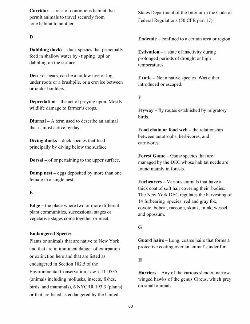
Corridor – areas of continuous habitat that permit animals to travel securely from one habitat to another.
States Department of the Interior in the Code of Federal Regulations (50 CFR part 17).
Endemic – confined to a certain area or region.
Dabbling ducks – duck species that principally feed in hall ater by tipping or dabbling on the surface.
Estivation – a state of inactivity during prolonged periods of drought or high temperatures.
Den For bears, can be a hollow tree or log, under roots or a brushpile, or a crevice between or under boulders.
Exotic – Not a native species. Was either introduced or escaped.
F Depredation – the act of preying upon. Mostly wildlife damage to farmer‘s crops. Flyway – fly routes established by migratory
birds. Diurnal – A term used to describe an animal that is most active by day. Food chain or food web – the relationship
between autotrophs, herbivores, and carnivores. Diving ducks – duck species that feed
principally by diving below the surface
Forest Game – Game species that are managed by the DEC whose habitat needs are found mainly in forests.
Dorsal – of or pertaining to the upper surface.
Dump nest – eggs deposited by more than one female in a single nest. Furbearers – Various animals that have a
thick coat of soft hair covering their bodies. The New York DEC regulates the harvesting of 14 furbearing species: red and gray fox, coyote, bobcat, raccoon, skunk, mink, weasel, and opossum.
E
Edge – the place where two or more different plant communities, successional stages or vegetative stages come together or meet.
G Endangered Species Plants or animals that are native to New York and that are in imminent danger of extirpation or extinction here and that are listed as endangered in Section 182.5 of the Environmental Conservation Law § 11-0535 (animals including mollusks, insects, fishes, birds, and mammals), 6 NYCRR 193.3 (plants) or that are listed as endangered by the United
Guard hairs – Long, coarse hairs that forms a protective coating over an animal‘sunder fur.
H
Harriers – Any of the various slender, narrow- winged hawks of the genus Circus, which prey on small animals.
60
Harvest – proportion or number of a wildlife population brought to bag by hunters; in wildlife management, killing an animal.
Litter – the number of young born with each birthing.
M Herbivore – An animal that eats plants.
Mandibles – either the upper or lower part of the beak in birds. Herpetology – The scientific study of reptiles
and amphibians as a branch of Zoology. Marsupial – A mammal of the order Marsupialia that includes kangaroos, opossums, bandicoots and wombats. These females have pouches that contain mammary glands and that shelter the young until fully developed.
Hibernation – passing the winter or a portion of it in a state of sleep
Home Range – The area an animal travel in when looking for food, shelter or a mate
Humus – Material resulting from decayed plant and animal matter. It provides nutrients for plants and helps keep water in the soil.
Melanistic – Abnormally dark pigmentation of the skin or other tissues. Black pigmented.
Migratory Game Bird All wild ducks, geese, and brant. (These also are "migratory waterfowl"). Coot, Virginia rails, sora rails, and gallinules, woodcock and snipe.
Indigenous – a naturally occurring species. Insectivore – a mammal or organism that feeds on insects. Inventory – the process of counting or identifying animals.
Molt – the process of shedding or replacing feathers.
K Monogamous – term used when one male breeds with one female.
Keel – a ridge down the back or along the plastron of a turtle or a longitudinal ridge On a dorsal scale in certain snakes.
Mortality (death rate) – the number of animals that die each year.
L
Lateral – pertaining to the side. Natality (birth rate) – ability of a population to increase; reproductive rate.
Limiting factor – Anything that affects a species population. It could result from causes in nature as well as human activities. Examples include food, water, shelter, space, disease, predation, climatic conditions, pollution, hunting, poaching and accidents.
Niche – that part of a habitat particularly suited to the requirements of a given species.
Nocturnal – active by night; the opposite of diurnal.
61
Nonconsumptive use – any use that does not directly kill wildlife, i.e. bird watching, hiking, photography.
Recruitment – addition of a number of young to an adult population of breeders.
Riparian area – the area of influence between upland habitats and aquatic habitats. O
Omnivore – An animal or organism that feeds on both animal and plant matter.
SAV (submerged aquatic vegetation) – vascular plants that live and grow completely underwater.
Ornithology – The scientific study of birds as a branch of zoology.
P Scat – The excrement droppings of an animal.
Parasite – an organism that lives by deriving benefit (usually doing harm) from another organism.
Species – populations of animals that possess common characteristics and freely interbreed in nature and produce fertile offspring.
Philopatry – annual homing to the same nesting area and often the same nest site.
Species richness – the number of wildlife species found in a given area.
Polygamy or polygyny – term used when a male animal breeds with many females.
T
Taxonomy – the science of the classification of animals or plants. Passerine – Birds of the order Passeriformes,
which include perching birds and songbirds such as the jays, blackbirds, finches, warblers and sparrows.
Torpor – temporary loss of all or part of the power of motion.
Pelage – The coat of a mammal, consisting of hair, fur, wool or other soft covering, as distinct from bare skin.
Trophic level – a feeding level in the food chain of an ecosystem characterized by Organisms that occupy a similar functional position in the ecosystem.
Population – the number of a particular species in a defined area. U, V, W
Population dynamics – factors regulating population levels including natality, productivity and mortality.
Upland game – Game species that are managed by the DEC whose habitat needs are usually found in upland areas.
Plastron – The ventral surface of the shell of a turtle or tortoise.
Ventral – of or pertaining to the lower surface.
Waterfowl – water birds, usually referring to ducks, geese and swans.
62

___________________________________________________________________________ENVIROTHON:WILDLIFESUGGESTEDACTIVITES
1. Explain the meaning of the terms "migration route" and "flywayǁ. Know the four major North American flyways and understand the importance of these routes to migratory land, water and shore birds.
2. Determine which common wildlife species in your area depend on open land, woodland and wetland habitat for their survival. Identify the various types of habitat within open lands, woodlands, and wetlands, and explain the importance of these specific habitats to common wildlife species within your area.
3. Explain why human use of land is the major reason for habitat loss. Provide examples of habitat destruction, fragmentation, and degradation and explain how wildlife species survival is threatened by habitat loss in your area.
4. Research and analyze controversial issues in order to understand the relationship between wildlife, economics and society. Penn. State School of Forest Resources: The Social and Economic Impact of Wildlife and Natural Resource Management Lesson Plan
5. Make a list of wildlife management practices and strategies that will restore or improve habitat for each of the following land uses: cropland, grassland, woodland, wetland, pond/lake, and urban setting (backyards, greenways, urban parks). Include specific wildlife species that will benefit from each wildlife practice or strategy.
6. Make a list of the Federal and State Fish and Wildlife Agencies within your state or province. Determine how each protects and manages the wildlife resources of your area, and describe activities and programs that are undertaken to protect and manage wildlife and their habitats.
7. Explain regulated trapping procedures and discuss the issues that are involved in trapping furbearing animals. Research and explain the dilemma of biological carrying capacity vs. cultural carrying capacity in your discussion.
8. Explain how Wildlife Managers are using Satellite Remote Sensing, GPS and GIS in Conservation and Wildlife Management. Give an example explaining the benefits of using this technology in remote areas.
63

What Does a Wildlife Biologist Do? Wildlife Biologists are scientists that observe and study the behaviors of animals. They frequently observe the features of certain wildlife and determine the creatures' role in specific ecosystems and/or how they interact with human beings. In addition, they will often perform various experiments to either increase our knowledge about a certain species or see how humans influence the ecosystem in question.
Many Wildlife Biologists will eventually specialize into a particular area of study defined by ecosystem or species. Some of these fields include: Entomology, Ornithology, Marine Biology, or Limnology.
Wildlife Biologists are extremely important to preserving the current state of our environment and deepening our understanding of the other creatures that share our planet with us.
Becoming a Wildlife Biologist is a fantastic position for someone who enjoys spending time outdoors and traveling. Many Wildlife Biologists spend the majority of their time working in the field, observing animals in their natural habitats. Some Wildlife Biologists work in labs or offices, but many only find themselves in these locations for small amounts of time. This is the perfect career for an adventurer who likes to work in a variety of environments.
Wildlife Biologists often cite physical exhaustion and loneliness as the top job hazards. They may be required to spend time in remote areas without modern conveniences and work long hours for observational purposes. Some kinds of work will require you to have limited contact with other people, possibly straining relationships and personal emotions.
However, it's important to note that Wildlife Biologists do not always work alone. In fact, many of them work on research teams, meaning that they may unite with colleagues at the end of an observation period to discuss findings According to the Bureau of Labor Statistics, the average Wildlife Biologist's salary is $57,710. Most Wildlife Biologists work full-time with the potential to work overtime or evening hours depending on their subject of study.
64

Notes
65

Oral Presentation ENVIROTHON CURRENT TOPIC
TheoralpresentationstationoffersEnvirothonteamsachancetoaddressreal-lifeenvironmentalproblemsaspresentedthroughawrittenscenario.Thepresentationtestsateam’sabilitytoconsideranenvironmentalissue,discussitslikelyramificationsandeffects,developpossiblesolutions,andpresenttheirfindingstoapanelofjudges.Theoralpresentationoffersstudentsachancetohonetheirpublicspeaking,problemsolvingandpresentationskills.
Teamswilladdressatotaloffivejudges.Eachteamwillhaveupto10minutestomaketheirpresentationfollowedby5minutesofquestionsfromthejudges.Eachteamisaskedquestionsbasedontheirrecommendationsandscoredaccordinglybythepanelofjudges.ThisisagreatopportunityforstudentstoworktogetherandapplysomeofthethingstheyhavelearnedwhilestudyingfortheEnvirothoncompetition.Teamsdiscusstheirfindingspriortopresentationtimeanddecidewhichoftheirrecommendationsisfeasibleinareallifesituation.Theyareaskedtodefendandexplaintheirrecommendedactions.StudentsarejudgedontheirabilitytothinkontheirfeetandincorporatetheirexistingknowledgeofSoil/LandUse,AquaticEcology,Wildlife,Forestryandtheyear'scurrentissuetopic.
66
ENVIROTHON–ORALPRESENTATIONRULES
The oral presentation component will be totaled into the team‘s final score just like the five other components (aquatics ecology, forestry, soil and land use, wildlife, and environmental issues). It is be 1/6 of the final score.
A panel of five judges will score the presentation. There will be seven sets of judges because of the numbers and the time frame.
Teams should include both pros and cons in their presentation.
All five members must participate. Each must have a speaking part. The alternate will not be allowed to participate.
Students will be allowed to prepare visual aids. Only materials contained in the visual aids packet that teams receive after their local competition can be used. Students may use both sides poster board, construction paper, and index cards.
These are:
2 sheets of white poster board (22ǁx 28ǁ) 1 small box of markers (8 colors)
package assorted (10 colors) of construction paper (9ǁx12ǁ) 1 bottle of glue (about 3 oz.)
pencils #2 4x6 index cards 1 roll of Scotch tape Scissors
Students may be as creative as they want but must not use any materials not listed. Visual aids will be inspected prior to the presentations. Use of anything not on the list (staples, ball-point pen, etc) will disqualify the visual aids and teams will not be allowed to use them.
Each member of the group is allowed to use one prepared note card (4ǁx6ǁonly) to aid them in their presentation. Note cards are not to be used as visual aids.
Students should work with fellow team members to prepare for the problem solving.
Teams may organize team members in any way, but are reminded all team members must participate. Costumes or e ng the pa a e not allowed. Only listed materials may be used.
There is to be no direct contact with the judges during the presentation. No brochures, handouts, pamphlets, etc. will be allowed to be distributed.
67

EXAMPLE OF THE 2015 New York State Envirothon Oral Presentation Judge‟s Score Sheet
Topic Problem: Urban Forestry
Not at all Poor or poorly Fair or slightly well Good or fairly well Excellent or very well
10 Outstanding (Each aspect is worth 10 points for a total of 200 points)
A. The Presentation: (Maximum 120 points) Circle Score
2. Outlined a sustainable urban forestry program, including a description of the program team and the urban forestry management plan that will guide its activities. 10
3. Demonstrated a comprehensive understanding of what an urban forest management plan is and how it works to maximize benefits and minimize threats over the long-term. 10
4. Explained the environmental benefits of the urban forest, including those related to climate, water, air and wildlife. 10
5. Explained the economic benefits of the urban forest, including those related to energy costs, property values, storm damage, and consumer behavior. 10
6. Explained the social benefits of the urban forest, including those related to community pride, health and wellbeing, noise pollution and screening buffers. 10
7. Described the threats to the urban forest, including invasive species, pests and diseases, climate change, encroaching development and lack of management capability. 10
8. Program addressed how to minimize costs associated with installation, maintenance, program administration and liability/litigation issues. 10
9. Included a plan to specifically address the threat of the Emerald Ash Borer, including preventative, salvage, and replacement efforts. 10
10. Showed how the program will be cost-effective by generating income and reducing costs. 10 11. Included measures for engaging the community and described how the environmental, financial, safety, and
aesthetic, concerns of the community groups will be addressed and conflicts will be resolved. 10 12. Presented a summary statement of the program with a synopsis of why is should be implemented.
10
Total Section A
68
8 6 4 2 0
8 6 4 2 0
8 8
6 6
4 4
2 2
0 0
8 6 4 2 0
8 6 4 2 0
8 6 4 2 0
8 6 4 2 0
8 6 4 2 0
8 6 4 2 0
8 6 4 2 0
1. Demonstrated a comprehensive understanding of what the urban and community forest is, including the variety of tree planting types and locations that make up the urban forest. 0 2 4 6 8 10
Judge‘s initials
Room Number Team Number
0 2 4
8

13. Presentation was well organized with a clear introduction and strong conclusion. 10 14. Presentation showed creative ideas, clearly stated and supported. 10 15. Participants enhanced the presentation (eye contact, gestures, voice inflection, exhibited professionalism, etc.)
10 16. References and resources were stated to support the presentation. 10 17. Visual aids made major points and showed conclusions. They were correct, eye appealing, readable and neat.
10 18. Questions from the judges were answered logically and concisely by all team members participating.
10
Total Section B
19. Each team member gets 2 points for equal oral participation in presentation. 10 20. Effective use of time was shown. Give 10 points (8-10 minutes); 6 points (7-8 minutes);
2 points (under 7 or over 10 minutes), (Time is called at 10 minutes) 10
Total Section C
Final Score out of 200
69
8 10 EXCELLENT 4 6 AVERAGE 0 2 POOR Scale for Scoring
8 6 4 2 0
8 6 4 2 0
C. Required Elements (Maximum Score 20) Circle Score
8 6 4 2 0
8 6 4 2 0
8 8
6 6
4 4
2 2
0 0
8 8
6 6
4 4
2 2
0 0
B. Quality of Presentation (Maximum Score 70) Circle Score

ENVIROTHON/2017CurrentEnvironmentalIssue
AgriculturalSoilandWaterConservationStewardship(currenttopic)
KeyTopics
Soil and Water Conservation best management practices; their purpose and implementation. How are soil and water conservation best management practices interrelated to the management of
wildlife, forestry and aquatic systems? How do agriculturists maintain a balance between their quality of life versus the quality of the
environment?
Learning Objectives
Upon completion of the training, the student will be able to: Identify and recommend soil and water conservation best management practices in agriculture. Describe the role of the federal government in conservation programs that benefit both agricultural
producers and the environment. Identify the concept of soil quality/health to provide the needed functions for the conservation planning
process. Identify various types of soil erosion and utilize different methods to estimate and predict soil erosion to
assess land use impacts. Revised Universal Soil Loss Equation, (RUSLE2) Aerial Photographs Topographic Maps Soil Maps USDA Classification System Soil Surveys
5. Explain why land-use planning is important to our ecosystems and to our economy to achieve sustainable agriculture.
71