Embed Size (px)
Citation preview
Filling the Archeological Void:Saint Lawrence Iroquoians in Alburg, Vermont
by Thomas R. Jamison
Introduction
Samuel de Champlain reported the presence of NativeAmerican groups around the north end of LakeChamplain prior to 1609 (Bassett 1967). However, thearcheology of Grand Isle County, Vermont, has onlybeen minimally examined. Characteristically for thecounty, previously identified sites in the town of Alburgare few. Until recently most of the sites identified in thetown were found by collectors and have not beenconfirmed by controlled excavation or placed chrono-logically or culturally. Almost all are located on pointsor bays around the lake-side perimeter of the town. Thisvoid is beginning to be addressed. The Bohannon Site(VT-GI-26/32) was recently excavated by the Universityof Vermont and several important sites were identifiedduring preliminary survey for a fire district water projectin the Fall of 2004 and during 2005. The fire districtproj ect provided an opportunity to examine a broad crosssection of topographic and environmental settings forevidence of pre contact occupation. Of particular impor-tance, the Bohannon Site and several others, shed lighton the presence in the area of. the Saint LawrenceIroquoians, a possibility suggested by James Pendergast(Petersen et al. 2004:88; Pendergast 1993:Figures. 1-3)and elaborated extensively by Jim Petersen (Petersen1990; Petersen et al. 2004).
Setting
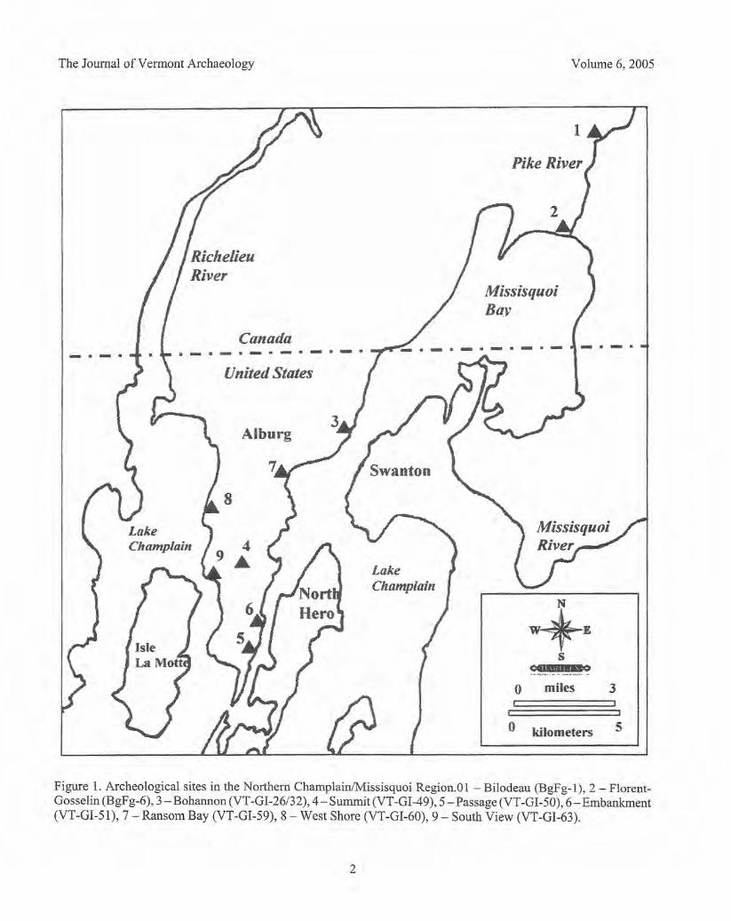
The town of Alburg consists of a long north-southtrending peninsula that extends from Canada 18.44kilometers (11.46 miles) into the northern end of LakeChamplain (Figure 1). At the southern end of thepeninsula the lake narrows into the Alburg Passage onthe east that runs between Alburg and the town of NorthHero and provides access to the outlet of the MissisquoiRiver and Missisquoi Bay. On the west the LamottePassage is formed by Alburg and Isle Lamotte andprovides access to the Richelieu River, the outlet of thelake and route to the Saint Lawrence River.
The bedrock that forms the underlying structure ofthe peninsula is the Stony Point formation consisting ofcalcareous shale grading upward into argillaceous lime-
stone and some dolomite (Doll et al. 1961). It is aprominent feature especially on the high ridge of thepeninsula, frequently forming sharp edges of thetopography that look artificial, but are due to the naturaltrend and cleavage of the shale.
Previous Research
James Pendergast, known for his extensive research onthe archeology of the Saint Lawrence Iroquoians,identified as early as 1987 the potential of a cluster ofSaint Lawrence Iroquoian occupation in the ChamplainValley based on ceramics from various collections fromthe area (petersen et al. 2004:88). Since then, exca-vations in the Champlain Basin in Quebec haveidentified Saint Lawrence Iroquoian sites along the PikeRiver and Missisquoi Bay (Blais 1993). The BilodeauSite (BgFg-l) and the Florent-Gosselin Site (BgFg-6;Figure 1) are located about 6 kilometers (3.7 miles) apartwith the Bilodeau Site up the Pike River and the Florent-Gosselin Site on the west bank of the mouth of the PikeRiver on Missisquoi Bay. Excavations by the Universityof Montreal at both sites encountered Saint LawrenceIroquoian ceramics and at the Bilodeau Site a pattern ofpostmolds and features suggest the outline of an oblongstructure about 15 meters (49 feet) in length (Blais1993:Figure 4)
The Bohannon Site (VT-GI-26/32) identified by theUniversity of Vermont in East Alburg on the shore ofLake Champlain across from Swanton (Figure 1) appearsto be a village site based on many pit features, some ofwhich may align to identify one or more longhousestructures (petersen et al. 2004: 109). Ceramics recoveredat the site include diagnostic Saint Lawrence Iroquoianattributes. A distinctly limited presence of lithic artifactsand the focus of artifacts in the vicinity of features aretraits also indicative of Saint Lawrence Iroquoian sites(Petersen et al. 2004: 113). In addition, the numerous pitfeatures extending below the plowzone containedextensive floral and faunal remains that have helped todate and interpret the site. AMS (Accelerator MassSpectrometry) dating suggests the site was occupiedapproximately AD 1500-1620 (petersenetal. 2004:110).
1
The Journal of Vermont Archaeology Volume 6, 2005
Canada-- _ .• .-.. -,.~.-.-.
Missisquo!Bav
LakeChamplain
~Es
CO··'WQ......•... ", .. ,... .._,.- •... -o
j
miles 3
United States
Alburg
o kilometers 5
Figure 1. Archeological sites in the Northern ChamplainiMissisquoi Region.Ol - Bilodeau (BgFg-l), 2 - Florent-Gosselin (BgFg-6), 3 - Bohannon (VT-GI-26/32), 4- Summit (VT-GI-49), 5 - Passage (VT -GI-50), 6- Embankment(VT-GI-51), 7 - Ransom Bay (VT-GI-59), 8 - West Shore (VT-GI-60), 9 - South View (VT-GI-63).
2
Saint Lawrence Iroquoians in Alburg
a N"Il",iveT.st
31 • Positive Test
"i'"o
VT.(iJ49 The Summit Site
Shovel Test Locations
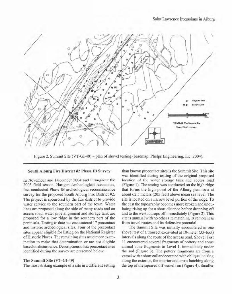
Figure 2. Summit Site (VT-GI-49) - plan of shovel testing (basemap: Phelps Engineering, Inc. 2004).
South Alburg Fire District #2 Phase IB Survey
In November and December 2004 and throughout the2005 field season, Hartgen Archeological Associates,Inc. conducted Phase IB archeological reconnaissancesurvey for the proposed South Alburg Fire District #2.The project is sponsored by the fire district to providewater service to the southern part of the town. Waterlines are proposed along the side of many roads and anaccess road, water pipe alignment and storage tank areproposed for a low ridge in the southern part of thepeninsula. Testing to date has encountered 17 precontactand historic archeological sites. Four of the precontactsites appear eligible for listing on the National Registerof Historic Places. The remaining sites need more exam-ination to make that determination or are not eligiblebased on disturbance. Descriptions of six precontact sitesidentified during the survey are presented below.
The Summit Site (VT -GI-49)The most striking example of a site in a different setting
than known pre contact sites is the Summit Site. This sitewas identified during testing of the original proposedlocation of the water storage tank and access road(Figure 1). The testing was conducted on the high ridgethat forms the high point of the Alburg peninsula atabout 62.5 meters (205 feet) above mean sea level. Thesite is located on a narrow level portion of the ridge. Tothe east the topography becomes more broken and undu-lating rising up for a short distance before dropping offand to the west it drops off immediately (Figure 2). Thissite is unusual with no other site matching its remotenessfrom travel routes and its defensive potential.
The Summit Site was initially encountered in oneshovel test of a transect excavated at lO-meter (33-foot)intervals along the route of the access road. Shovel Test11 encountered several fragments of pottery and someanimal bone fragments in Level 1, immediately underthe sad (Figure 3). The pottery fragments are from avessel with a short collar decorated with oblique incisingalong the exterior, the interior and cross hatching alongthe top of the squared off vessel rim (Figure 4). Smaller
3

The Journal of Vermont Archaeology
.. rYVY'iY.,·.••......••.•..~
Figure 3. Summit Site (VT-GI-49), Test 11, Levell,incised thickened lip rim sherds, exterior (LanorieCrossed).
Figure 4. Summit Site (VT-GI-49), Test 11, Levell,incised thickened lip rim sherds, view of cross hatchingon the top of the flattened rim (Lanorie Crossed).
body sherds, possibly from the same vessel, exhibit acheck stamped decoration that spalled off (Figure 5).The bone found in the test consists of a few small,unburned fragments that appear to be of deer vertebrae.
Confirmation tests were excavated at 5-meter inter-vals around Test 11 and one, Test 31, excavated 5 metersto the southwest, encountered additional pottery of asmaller vessel but with similar rim decoration accom-plished through a combination of incising and cord-wrapped stick impression (Figure 6). Although appliedthrough different techniques, the design is similar to thevessel in Test 11, with crosshatching on the top of thesquared rim.
In an effort to get some sense of the boundaries of
Volume 6, 2005
Figure 5. Summit Site (VT-GI-49), Test 11, Levell,check stamped body sherds, perhaps from the samevessel as the Lanorie Crossed sherds in Figures 3 and 4.
the site, a second round of testing was conducted. Thesetests extended in transects out from Tests 11 and 31 tothe southeast, northeast and southwest (Figure 2). Tests177 and 191 each encountered one small, undecoratedpottery sherd. Both tests were located about 17 meters(56 feet) to the northeast of Test 11. In addition, Test166 encountered a thin lens of charcoal at the base of theA horizon and Test 207 encountered a reddened subsoilon one side of the test. No artifacts were found inassociation with either deposit, but they may representprecontact features.
The Passage Site (VT-GI-50)The Passage Site is located along the west side of Poor
4
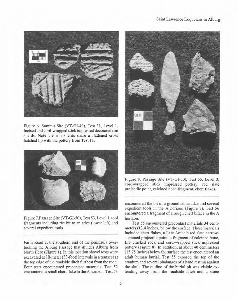
Figure 6. Summit Site (VT -GI-49), Test 31, Level 1,incised and cord-wrapped stick impressed decorated rimsherds. Note the rim sherds share a flattened crosshatched lip with the pottery from Test 11.
Figure 7.Passage Site (VT-GI-50), Test 53, Levell, toolfragments including the bit to an adze (lower left) andseveral expedient tools.
Farm Road at the southern end of the peninsula over-looking the Alburg Passage that divides Alburg fromNorth Hero (Figure 1). In this location shovel tests wereexcavated at lO-meter (33-foot) intervals in a transect atthe top edge of the roadside ditch furthest from the road.Four tests encountered precontact materials. Test 52encountered a small chert flake in the A horizon. Test 53
Saint Lawrence Iroquoians in Alburg
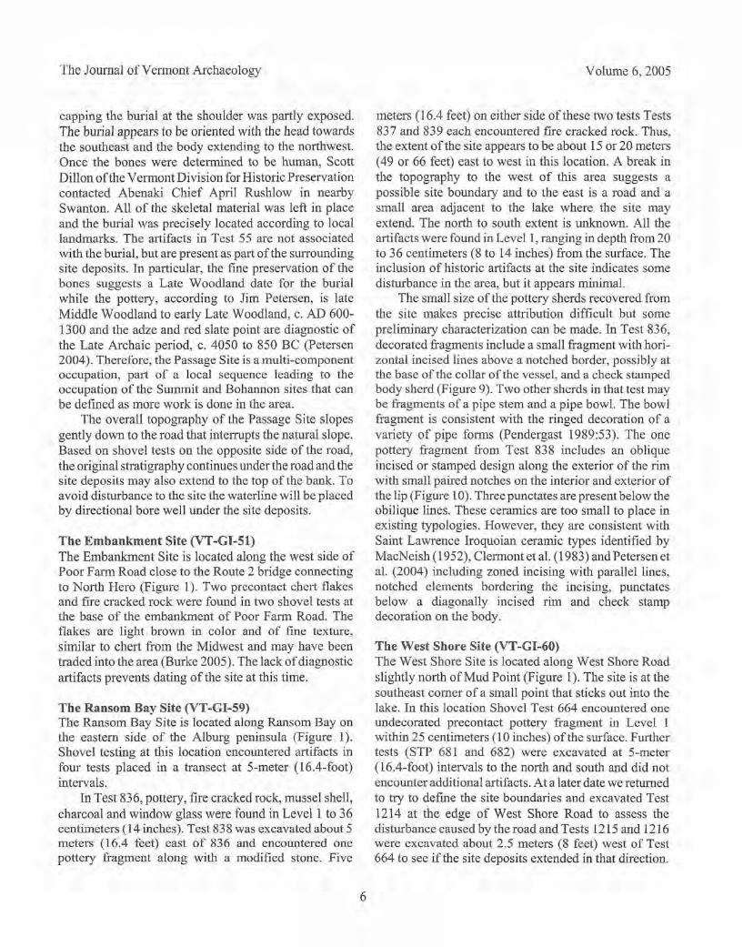
Figure 8. Passage Site (VT-GI-50), Test 55, Level 3,cord-wrapped stick impressed pottery, red slateprojectile point, calcined bone fragment, chert flakes.
encountered the bit of a ground stone adze and severalexpedient tools in the A horizon (Figure 7). Test 56encountered a fragment of a rough chert biface in the Ahorizon.
Test 55 encountered precontact materials 34 centi-meters (13.4 inches) below the surface. These materialsincluded chert flakes, a Late Archaic red slate narrow-stemmed projectile point, a fragment of calcined bone,fire cracked rock and cord-wrapped stick impressedpottery (Figure 8). In addition, at about 40 centimeters(15.75 inches) below the surface the test encountered anadult human burial. Test 55 exposed the top of thecranium and several phalanges of a hand resting againstthe skull. The outline of the burial pit was visible ex-tending away from the roadside ditch and a stone
5
The Journal of Vermont Archaeology
capping the burial at the shoulder was partly exposed.The burial appears to be oriented with the head towardsthe southeast and the body extending to the northwest.Once the bones were determined to be human, ScottDillon of the Vermont Division for Historic Preservationcontacted Abenaki Chief April Rushlow in nearbySwanton. All of the skeletal material was left in placeand the burial was precisely located according to locallandmarks. The artifacts in Test 55 are not associatedwith the burial, but are present as part of the surroundingsite deposits. In particular, the fine preservation of thebones suggests a Late Woodland date for the burialwhile the pottery, according to Jim Petersen, is lateMiddle Woodland to early Late Woodland, c. AD 600-1300 and the adze and red slate point are diagnostic ofthe Late Archaic period, c. 4050 to 850 BC (Petersen2004). Therefore, the Passage Site is a multi-componentoccupation, part of a local sequence leading to theoccupation of the Summit and Bohannon sites that canbe defined as more work is done in the area.
The overall topography of the Passage Site slopesgently down to the road that interrupts the natural slope.Based on shovel tests on the opposite side of the road,the original stratigraphy continues under the road and thesite deposits may also extend to the top of the bank. Toavoid disturbance to the site the waterline will be placedby directional bore well under the site deposits.
The Embankment Site (VT-GI-51)The Embankment Site is located along the west side ofPoor Farm Road close to the Route 2 bridge connectingto North Hero (Figure 1). Two precontact chert flakesand fire cracked rock were found in two shovel tests atthe base of the embankment of Poor Farm Road. Theflakes are light brown in color and of fine texture,similar to chert from the Midwest and may have beentraded into the area (Burke 2005). The lack of diagnosticartifacts prevents dating of the site at this time.
The Ransom Bay Site (VT -GI-59)The Ransom Bay Site is located along Ransom Bay onthe eastern side of the Alburg peninsula (Figure I).Shovel testing at this location encountered artifacts infour tests placed in a transect at 5-meter (16.4-foot)intervals.
In Test 836, pottery, fire cracked rock, mussel shell,charcoal and window glass were found in Levell to 36centimeters (14 inches). Test 838 was excavated about 5meters (16.4 feet) east of 836 and encountered onepottery fragment along with a modified stone. Five
Volume 6, 2005
meters (16.4 feet) on either side ofthese two tests Tests837 and 839 each encountered fire cracked rock. Thus,the extent of the site appears to be about 15 or 20 meters(49 or 66 feet) east to west in this location. A break inthe topography to the west of this area suggests apossible site boundary and to the east is a road and asmall area adjacent to the lake where the site mayextend. The north to south extent is unknown. All theartifacts were found in Levell, ranging in depth from 20to 36 centimeters (8 to 14 inches) from the surface. Theinclusion of historic artifacts at the site indicates somedisturbance in the area, but it appears minimal.
The sma1l size of the pottery sherds recovered fromthe site makes precise attribution difficult but somepreliminary characterization can be made. In Test 836,decorated fragments include a small fragment with hori-zontal incised lines above a notched border, possibly atthe base of the collar of the vessel, and a check stampedbody sherd (Figure 9). Two other sherds in that test maybe fragments of a pipe stem and a pipe bowl. The bowlfragment is consistent with the ringed decoration of avariety of pipe forms (Pendergast 1989:53). The onepottery fragment from Test 838 includes an obliqueincised or stamped design along the exterior of the rimwith small paired notches on the interior and exterior ofthe lip (Figure 10). Threepunctates are present below theobilique lines. These ceramics are too small to place inexisting typologies. However, they are consistent withSaint Lawrence Iroquoian ceramic types identified byMacNeish (1952), Clermont et al. (1983) and Petersen etal. (2004) including zoned incising with parallel lines,notched elements bordering the incising, punctatesbelow a diagonally incised rim and check stampdecoration on the body.
The West Shore Site (VT-GI-60)The West Shore Site is located along West Shore Roadslightly north of Mud Point (Figure 1). The site is at thesoutheast comer of a small point that sticks out into thelake. In this location Shovel Test 664 encountered oneundecorated precontact pottery fragment in Level 1within 25 centimeters (10 inches) of the surface. Furthertests (STP 681 and 682) were excavated at 5-meter(16.4-foot) intervals to the north and south and did notencounter additional artifacts. At a later date we returnedto try to define the site boundaries and excavated Test1214 at the edge of West Shore Road to assess thedisturbance caused by the road and Tests 1215 and 1216were excavated about 2.5 meters (8 feet) west of Test664 to see if the site deposits extended in that direction.
6

Saint Lawrence Iroquoians in Alburg
Figure 9. Ransom Bay Site (VT-GI-59),Test 836, Levell, top: possible pipe stemfragment, undecorated sherds; bottom:check stamped shed, incised and notchedsherd, possible ringed pipe bowl fragment,undecorated sherd.
None of these tests encountered precontact artifacts. Test1214 excavated at the edge of pavement encountered 17centimeters (6.75 inches) of silty sand, underlain by 13centimeters (5 inches) of shale road fill and 26 centi-meters (10.25 inches) of clean sand before hitting thenatural clay subsoil at 56 centimeters (22 inches). Therewas no sign of the dark brown clayey silt that forms theA horizon in the surrounding tests. Finally, a 1- by 1-meter (3.3- by 3.3-foot) unit was excavated with Test664 forming the southwest comer. One small un-decorated pottery fragment was encountered at about 15centimeters (6 inches) below the surface in the A horizonof the unit, about 10 centimeters (4 inches) above thesubsoil. No additional artifacts were encountered.
The density of artifacts encountered at the WestShore Site appears to be less than at other precontactsites encountered around Alburg. However, the charac-teristics of Saint Lawrence lroquoian sites must be takeninto account. They are typically characterized by widelydistributed artifact concentrations with broad areas ofopen space free of artifacts. The West Shore Site couldbe such a situation with the sherds in Test 664 and Unit1 being set apart from other deposits. It is also possiblethat the pottery derives from the occupation ofthe site byanother group such as the Abenaki or proto-Abenaki,Further analysis of the pottery may help in thatdetermination. It is possible that the small point oflandacross the road from the testing that is now occupied bytwo houses may contain more deposits associated with
the site. Judging by Test 1214 it appears the roadconstruction in this vicinity has removed the A horizoncontaining most of the site deposits. It is possible there
Figure 10. Ransom Bay Site (VT-GI-59), Test 838,Level 1 stamped lip rim sherd with punctates belowthe rim.
7
The Journal of Vermont Archaeology
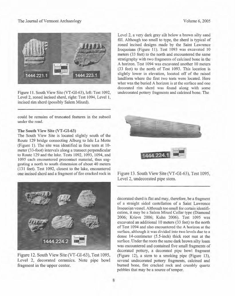
Figure 11. South View Site (VT-GI-63), left: Test 1092,Level 2, zoned incised sherd, right: Test 1094, Levell,incised rim sherd (possibly Salem Mixed).
could be remains of truncated features in the subsoilunder the road.
The South View Site (VT-GI-63)The South View Site is located slightly south of theRoute 129 bridge connecting Alburg to Isle La Motte(Figure 1). The site was identified in four tests at 10-meter (33-foot) intervals along a transect perpendicularto Route 129 and the lake. Tests 1092, 1093, 1094, and1095 each encountered precontact material, thus sug-gesting a north to south dimension of about 40 meters(131 feet). Test 1092, closest to the lake, encounteredone incised sherd and a fragment of fire cracked rock in
Figure 12. South View Site (VT-GI-63), Test 1095,Level 2, decorated ceramics. Note pipe bowlfragment in the upper center.
Volume 6, 2005
Level 2, a very dark gray silt below a brown silty sandfill. Although too small to type, the sherd is typical ofzoned incised designs made by the Saint Lawrencelroquoians (Figure 11). Test 1093 was excavated 10meters (33 feet) to the north and encountered the samestratigraphy with two fragments of calcined bone in theA horizon. Test l094 was excavated another 10 meters(33 feet) to the north of Test 1093. This location isslightly lower in elevation, located off of the raisedlandform where the first two tests were located. Herewhat was the buried A horizon is at the surface and onedecorated rim sherd was found along with someundecorated pottery fragments and calcined bone. The
-Figure 13. South View Site (VT-GI-63), Test 1095,Level 2, undecorated pipe stem.
decorated sherd is flat and may, therefore, be a fragmentof a straight sided castellation of a Saint LawrenceIrouuoian vessel. Although too small for certain identifi-cation, it may be a Salem Mixed Collar type (Diamond2006; Krievs 2006; Kuhn 2006). Test 1095 wasexcavated an additional 10 meters (33 feet) to the northof Test 1094 and also encountered the A horizon at thesurface, although it was divided into two levels due to adense 14-centimeter (5.S-inch) thick root mat at thesurface. Under the roots the same dark brown silty loamwas encountered and contained five small fragments ofdecorated pottery, a decorated pipe bowl fragment(Figure 12), a stem to a smoking pipe (Figure 13),several undecorated pottery fragments, calcined andburned bone, fire cracked rock and crumbly quartzpebbles that may be a source of temper.
8
The decorated pottery fragments represent severaldifferent decorative techniques including incising, lightimpressions and dentate stamped impressions. Thefragments are consistent with Saint Lawrence Iroquoianpottery documented by MacNeish (1952), Clermont etal. (1983) and Petersen et al. (2004). The pipe bowlfragment and stem appear to be Saint LawrenceIroquoian in origin.
Interpretation
The sites identified in Alburg provide a beginning pointfor developing of a regional definition of precontactoccupation that can be added to any information fromother sites or collections in the area. Jim Petersen visitedthe project in the fall of2004 and examined the artifactsfrom the Summit and Passage Sites. Beginning with thePassage Site, a Late Archaic (c. 4050 to 850 BC) occu-pation is suggested by the adze fragment and the redslate point (Petersen 2004). This occupation may becontemporaneous with the Late Archaic site VT-GI-18identified by DVM CAP on the west shore of Grand Islein 1989 (DVM CAP 1992). The later pottery found at thePassage Site identifies a late Middle Woodland to earlyLate Woodland, c. AD 600-1300 occupation (Petersen2004), probably including the burial.
Petersen identified the Summit Site pottery as SaintLawrence Iroquoian in design (Petersen 2004). Theincising and check stamped designs on the Test 11sherds are diagnostic of Saint Lawrence Iroquoian andprobably date to about AD 1400. The sherds from Test31 exhibit a combination of zoned incising and cord-wrapped stick impressed decoration, again probablySaint Lawrence Iroquoian, possibly contemporary withthe Test 11 vessel. It is interesting to note that althoughthe two different vessels identified were very different insize and technique of decoration, they share the crosshatched decoration on the top of flattened vessel rims,possibly indicating uniform cultural identity and timeperiod.
The identification of the Summit Site as SaintLawrence Iroquoian is also supported by negativeevidence. Although 90 tests were excavated at 5-meter(16.4-foot) intervals in fairly close proximity to thepositive tests, no lithic artifacts were encountered(Figure 2). This lack oflithic debitage and tools is foundto be characteristic of Saint Lawrence lroquoian siteswhere bone tools often form a higher percentage of thetool assemblage than stone. That was the case at theBohannon site where the site was identified based on
Saint Lawrence Iroquoians in Alburg
ceramics with very few lithics present (Mandel et al.2001). This pattern has also been noted on other SaintLawrence lroquoian sites in southern Quebec (Clermontand Gagne 2004:80) and elsewhere.
The limited ceramic collections from the RansomBay Site and the South View Site also exhibit classicSaint Lawrence Iroquoian attributes (Diamond 2006;Krievs 2006; Kuhn 2006). At the Ransom Bay Site thenotched and incised sherd and the check stamped sherdare typical of Saint Lawrence Iroquoian vessels (Figure9). The sherd encountered in Test 838 is characterized asa thickened lip form that includes incising and notchingalong the lip and punctates under the lip (Figure 10).Although this sherd is unusual, it has classic SaintLawrence lroquoian attributes. The fragmentary natureof the ceramics from these sites does not allow for achronological or typological placement ofthe ceramics,but they clearly fit into a sequence of Saint LawrenceIroquoian occupation of the area.
The Bohannon Site appears to be a late, possiblycontact period, occupation (Petersen et al. 2004: 110).The estimation of the Summit site ceramics dating to AD1400 adds support to Pendergast's contention (high-lighted by Petersen et al. 2004: 115) that Saint Lawrencelroquoians were at least visiting and utilizing portions ofnorthwestern Vermont during an extended period, notjust as refugees or captives during the late precontact-early contact periods.
With such a small amount of excavation to date thenature of the Summit site is unclear. The presence ofthepottery in four locations and possible features seems toindicate something more complex than a one time campor special use site. However, the high ridge location isunusual. It would seem to suggest a defensive posture orother special use. The distance from water sourcescontradicts Pendergast's observation that many SaintLawrence Iroquoian villages are located next to wetlandswhere, he hypothesized, they obtained dead poles for usein building defensive palisades. Instead, the site falls intohis category of sites where natural obstacles wereintegrated into defenses (Pendergast 1990:20), in thiscase an angular ridge line location.
The site as currently defined is limited to a narrowlevel portion of the northwestern edge of the ridgebounded on the northwest by an approximately 2.5-meter (8.2-foot) drop and to the southeast by a slightundulating rise that then drops down about 2 meters (6.6feet) approximately 27 meters (88.6 feet) to the south-east. The extremely shallow bedrock over most of thesite would most likely prohibit construction of a
9
The Journal of Vermont Archaeology
substantial palisade, therefore, the occupants probablyrelied on distance from traveled routes and topographyfor protection. In fact, Champlain's description of theNative American presence in the Champlain Islands in1609 is applicable. He had been told about earlier warsand suggested a motive for the local population to haveabandoned the shorelines, "They withdraw as deep intothe land as possible, to avoid surprise attacks." (Bassett1967:3-4). The potential for long distance observation ofthe countryside from the Summit Site vantage point wasprobably limited during the Late Woodland by forestcover. The location of the Bohannon Site is an exceptionto Champlain's characterization of contact period NativeAmerican settlement patterns, however.
In trying to draw correlations between the SummitSite and other Saint Lawrence Iroquoian sites, weconsulted MacNeish's 1952 study of Iroquois potteryand found the closest resemblance of the Test 11 pottery(Figures 3 and 4) to be with his Lanorie Crossed ceramictype defined from materials excavated at Lanoraie in the1930s (MacNeish 1952:64). Excavations there by theUniversity of Montreal in the 1970s provide morecontrolled data and analysis, including reconstruction ofvessels and the floor plan to a long house (Clermont etal. 1983). Of particular interest for the present discussionare two reconstructed vessels illustrated in their report(Clermont et al. 1983: 105-106). These vessels aredecorated similarly to the pottery at the Summit Sitewith combinations of dentate and cord-wrapped stickimpressions and incising with the body of the vesselsimpressed with check stamped designs. Lanorie Crossedpottery has also been identified in low frequencies atl5th
_ and 16th-century Saint Lawrence Iroquoian sites inJefferson County, New York (Engelbrecht 2004) and at17th-century Mohawk sites in central New York (Kuhn2004).
Lanoraie makes sense as a correlate for the SummitSite and other Vermont materials since it is located closeto the outlet of the Richelieu River making a relativelyeasily traveled corridor between the two areas. However,in a study attempting to define regional provinces ofSaint Lawrence Iroquoian occupation, Chapdelainegroups the ChamplainlMissisquoi area sites in hisHochelaga province located to the west based on potteryattributes while Lanoraie and the Mandeville Site at theoutlet of the Richelieu River are grouped with hisMaisouna province to the east (Chapdelaine 2004:68).Chapdelaine identifies the com ear motif on ceramicvessels as being an attribute typical of the sites in the
Volume 6, 2005
Hochelaga province (Chapdelaine 2004:70). Therefore,it makes sense for the Bohannon Site with vesselssporting the com ear motif (Petersen et al. 2004: 111) tobe included in the Hochelaga province, but perhapsearlier, when the Summit Site was occupied (accordingto Petersen c. AD 1400), the area was more aligned tothe east. Chapdelaine rightly stresses the tenuous natureof chronologies and affiliations developed from ceramictypologies and attributes (Chapdelaine 2004:68-69). Theneed for detailed controlled excavation at numerous sitesis highlighted by the few tantalizing clues obtained fromeach site examined in the South Alburg Fire District #2survey. Only when such studies are conducted can webegin to place the Champlain Basin in a regional contextof pre contact occupation.
Conclusion
The preliminary definition of the sites identified duringthe South Alburg Fire District #2 survey has contributedto our understanding of the archeology of northern LakeChamplain and indicates the great archeologicalpotential of this little known region of the ChamplainIslands. In particular, the Summit Site, the Ransom BaySite, and the South View Site punctuate the work at theBohannon site and add to our understanding of the SaintLawrence lroquoian presence in the area. However, allneed to be placed as segments of a local continuum ofoccupation that is beginning to be defined and set in thebroader regional context.
Acknowledgements
Ithank a number of people and institutions for their helpand inspiration. Foremost is Jim Petersen, who was afount of knowledge of archeology, and ceramics inparticular, given with the joy that he led his life toanyone who asked for assistance. I only knew Jimbriefly, but in those few years I learned he was one to begreatly admired for his love of life and the pursuit ofknowledge. He is deeply missed. Others who helped meto understand some of the issues and data involved inthis paper include Bill Bouchard, Adrian Burke, Hetty JoBrumbach, Joe Diamond, Scott Dillon, Karen Hartgen,Matt Kirk, Andre Krievs, and Bob Kuhn. Finally, theSouth Alburg Fire District #2 and Phelps Engineering,Inc. provided the opportunity to conduct the survey andencouraged this and other presentations of the results.
10

Bibliography
Bassett, T. D. Seymour (editor)1967 Samuel de Champlain: On the Warpath (1609).In: Outsiders Inside Vermont: Three centuries ofvisitors' viewpoints on the Green Mountain State,Phoenix Publishing, Canaan, New Hampshire.
Blais, Judith1993 The Bilodeau Site Near Missisquoi Bay:Postmolds, Fishbones and Com Ear Motifs. In: Essays inSt. Lawrence Iroquoian Archaeology, James F.Pendergast and Claude Chapdelaine (editors),Occasional Papers in Northeastern Archaeology No.8,Copetown Press, Dundas, Ontario, pp. 75-85.
Burke, Adrian2005 personal communication, April 9, 2005.
Chapdelaine, Claude2004 A Review of the Latest Developments in St.Lawrence Iroquoian Archaeology. In: A Passion/or thePast: Papers in Honour of James F. Pendergast, JamesV. Wright and Jean-Luc Pilon (editors), CanadianMuseum of Civilization, Gatineau, Quebec, pp. 63-76.
Clermont, Norman and Michel Gagne2004 People of the Drumlins. In: A Passion for thePast: Papers in Honour of James F. Pendergast, JamesV. Wright and Jean-Luc Pilon (editors), CanadianMuseum of Civilization, Gatineau, Quebec, pp. 77-86.
Clermont, Norman, Claude Chapdelaine, and GeorgesBarre1983 Le Site Iroquoien de Lanoraie: Temoignaged'une Maison-Longue. Recherches Amerindiennes auQuebec, Montreal.
Diamond, Joseph2006 personal communication, February 1,2006.
Doll, Charles G., Wallace M. Cady, James B.Thompson, Jr., and Marland P. Billings1961 Centennial Geologic Map of Vermont. State ofVermont Geological Survey, Waterbury, Vermont.
Engelbrecht, William2004 Northern New York Revisited. In: A Passion forthe Past: Papers in Honour of James F. Pendergast,James V. Wright and Jean-Luc Pilon (editors), Canadian
Saint Lawrence Iroquoians in Alburg
Museum of Civilization, Gatineau, Quebec, pp. 125-144.
Krievs, Andre2006 personal communication, February 1,2006.
Kuhn, Robert D.2004 Reconstructing Patterns of Interaction andWarfare between the Mohawk and Northern Iroquoiansduring the A.D. 1400-1700 Period. In: A Passion for thePast: Papers in Honour of James F. Pendergast, JamesV. Wright, and Jean-Luc Pilon (editors), CanadianMuseum of Civilization, Gatineau, Quebec, pp. 145-166.
2006 personal communication, February 3, 2006.
MacNeish, Richard S.1952 Iroquois Pottery Types: A Technique for theStudy of Iroquois Prehistory. National Museum ofCanada, Ottawa, Bulletin No. 124.
Mandel, Geoffrey, James B. Petersen, and PrudenceDoherty2001 Phase I Site Identification and Phase II SiteEvaluation for Alburg-Swanton BRF 036-1(1) BridgeReplacement, Alburg, Grand Isle County, Vermont.Consulting Archaeology Program Report 264,University of Vermont.
Pendergast, James F.1989 Some Notes on Ceramic Smoking Pipes from St.Lawrence Iroquoian Archaeological Sites. In:Proceedings of the 1989 Smoking Pipe Conference:Selected Papers, Charles F. Hayes III (general editor),Rochester Museum and Science Center, ResearchRecords No. 22, pp. 51-61.
1990 Emerging Saint Lawrence Iroquoian SettlementPatterns. Man in the Northeast 40: 17-30.
1993 More on When and Why the St. LawrenceIroquoians Disappeared. In: Essays in St. LawrenceIroquoian Archaeology, James F. Pendergast and ClaudeChapdelaine (editors), Occasional Papers in NortheasternArchaeology No.8, Copetown Press, Dundas, Ontario,pp.9-47.
Petersen, James B.1990 Evidence of the Saint Lawrence Iroquoians inNorthern New England: Population Movement, Trade,or Stylistic Borrowing? Man in the Northeast 40: 31- 39.
11
The Journal of Vermont Archaeology
Petersen, James B. (cont'd)2004 personal communication, November 7,2004.
Petersen, James B., John G. Crock, Ellen R. Cowie,Richard A. Boisvert, Joshua R. Toney, and GeoffreyMandel2004 St. Lawrence Iroquoians in Northern NewEngland: Pendergast was "Right" and More. In: APassion for the Past: Papers in Honour of James F.Pendergast, James V. Wright and Jean-Luc Pilon(editors), Canadian Museum of Civilization, Gatineau,Quebec, pp. 87-123.
University of Vermont Consulting Archaeology Program(UVMCAP)1992 4,500 Years at Gordon's Landing: Archaeologyat the Grand Isle Fish Hatchery. ConsultingArchaeology Program, University of Vermont,Burlington.
Thomas R. Jamison is a project manager for HartgenArcheological Associates, Inc. in their Putney, Vermont,office that he helped to establish in 1997. He received aB.A. in Anthropology from Hamilton College in 1980and an MA. from the University at Albany in 1986. HisPhD from the University at Albany in 1993 was based onhis work at Early and Late Classic Maya sites insouthern Belize. He has been active in Cultural ResourceManagement since 1980 having worked in Texas, NewJersey, New York, New Hampshire, and Vermont.
Volume 6, 2005
12