Embed Size (px)
Citation preview

Comprehensive Marina Master Plan Page 4-1
Figure 4-1. Des Moines Marina Master Plan Recommendations
4. Master Plan Since completion of the previous Master Plan in 2001 economic conditions in the Des Moines and Puget Sound boating communities have changed, creating new opportunities for in-water and upland facilities at the Marina. In response to market projections, a series of recommendations have been developed as a means for the Marina to capitalize on these new opportunities. The sections that follow describe the Master Plan recommendations for the Marina’s individual elements. Figure 4-1 above provides a summary of the recommendations and can also be found as an 11 x 17 foldout at the back of this section. Cost estimates for all recommended actions can be found in Chapter 5.
Chapter 4
Page 4-2 MAKERS architecture and urban design 0326.01_MP Update.doc - 6/14/07
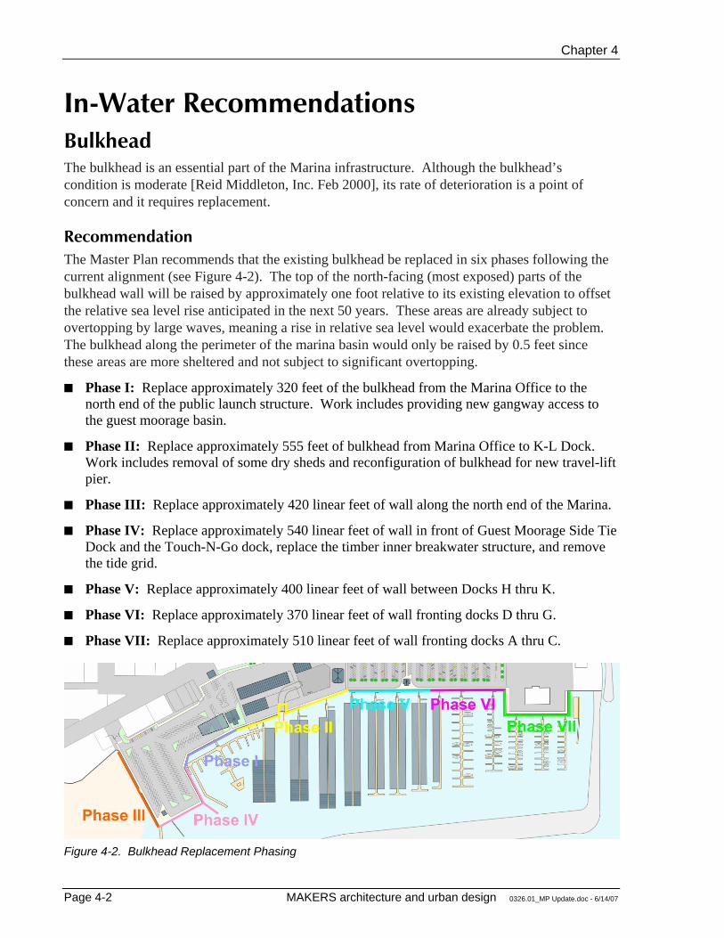
In-Water Recommendations Bulkhead The bulkhead is an essential part of the Marina infrastructure. Although the bulkhead’s condition is moderate [Reid Middleton, Inc. Feb 2000], its rate of deterioration is a point of concern and it requires replacement.
Recommendation The Master Plan recommends that the existing bulkhead be replaced in six phases following the current alignment (see Figure 4-2). The top of the north-facing (most exposed) parts of the bulkhead wall will be raised by approximately one foot relative to its existing elevation to offset the relative sea level rise anticipated in the next 50 years. These areas are already subject to overtopping by large waves, meaning a rise in relative sea level would exacerbate the problem. The bulkhead along the perimeter of the marina basin would only be raised by 0.5 feet since these areas are more sheltered and not subject to significant overtopping.
Phase I: Replace approximately 320 feet of the bulkhead from the Marina Office to the north end of the public launch structure. Work includes providing new gangway access to the guest moorage basin.
Phase II: Replace approximately 555 feet of bulkhead from Marina Office to K-L Dock. Work includes removal of some dry sheds and reconfiguration of bulkhead for new travel-lift pier.
Phase III: Replace approximately 420 linear feet of wall along the north end of the Marina.
Phase IV: Replace approximately 540 linear feet of wall in front of Guest Moorage Side Tie Dock and the Touch-N-Go dock, replace the timber inner breakwater structure, and remove the tide grid.
Phase V: Replace approximately 400 linear feet of wall between Docks H thru K.
Phase VI: Replace approximately 370 linear feet of wall fronting docks D thru G.
Phase VII: Replace approximately 510 linear feet of wall fronting docks A thru C.
Figure 4-2. Bulkhead Replacement Phasing
Master Plan
Comprehensive Marina Master Plan Page 4-3
Permanent Moorage The future of the fourteen floating docks is an important issue since in 2005 they generated $1.974 million (50%) of the Marina revenues. The costs involved in their replacement will be a substantial investment. It appears that the floating docks can be kept in serviceable condition until 2010 or beyond, but the anticipated future expenses and impacts are so significant that a discussion of the long-range replacement alternatives should be part of this process.
For their age, the floating docks and roof structures are in generally good condition. The major problems are loss of floatation in some areas and loss of structural integrity in a small number of the guide pilings. Also, the electrical distribution system on the larger docks is not adequate to supply the service demand of newer boats.
Although current environmental regulations strongly discourage the construction of new covered moorage on Puget Sound, existing covered moorage can be maintained, reconstructed, and relocated within the Marina. The primary drawbacks to rebuilding covered moorage involve structure height and cost. In order to minimize shadow impacts upon the water, environmental regulations will require new covered moorage structures to be higher than the existing structures.
The Municipal Facilities Committee, consultant, and staff examined several replacement alternatives for the permanent moorage docks to determine the potential slip mix and the construction and operating costs. The goal in analyzing these alternatives was to stay as close as possible to the current number of slips and to maintain current revenue levels without large rate increases. Another constraint was the amount of debt that can be carried by the Marina. The Master Plan recommends that total debt be kept below $12 million at any given time.
2001 Master Plan Preferred Alternative The preferred alternative included expansion of existing covered moorage and replacement of some docks. Variations of this alternative were the most attractive because of cost and the possibility of keeping the total number of slips close to current levels. In this alternative, which is referred to as Alternative #5B in the 2001 Master Plan, the open slips at the end of K, L, M and N Docks are replaced with new covered moorage and some of the smaller docks are replaced with new 36- to 50–foot open moorage. A caveat of this alternative is that the exact number of each slip size won’t be determined until the project is undertaken.
This alternative adjusts the existing slip mix to better reflect projected market changes. It reconfigures several docks as large-slip docks (with 40-foot and 50-foot slips) and has the potential ability to convert the open moorage at the ends of existing piers to covered moorage. The following tabulation compares the number and type of slips that could be provided by the preferred alternative with the current Marina configuration:
Chapter 4
Page 4-4 MAKERS architecture and urban design 0326.01_MP Update.doc - 6/14/07
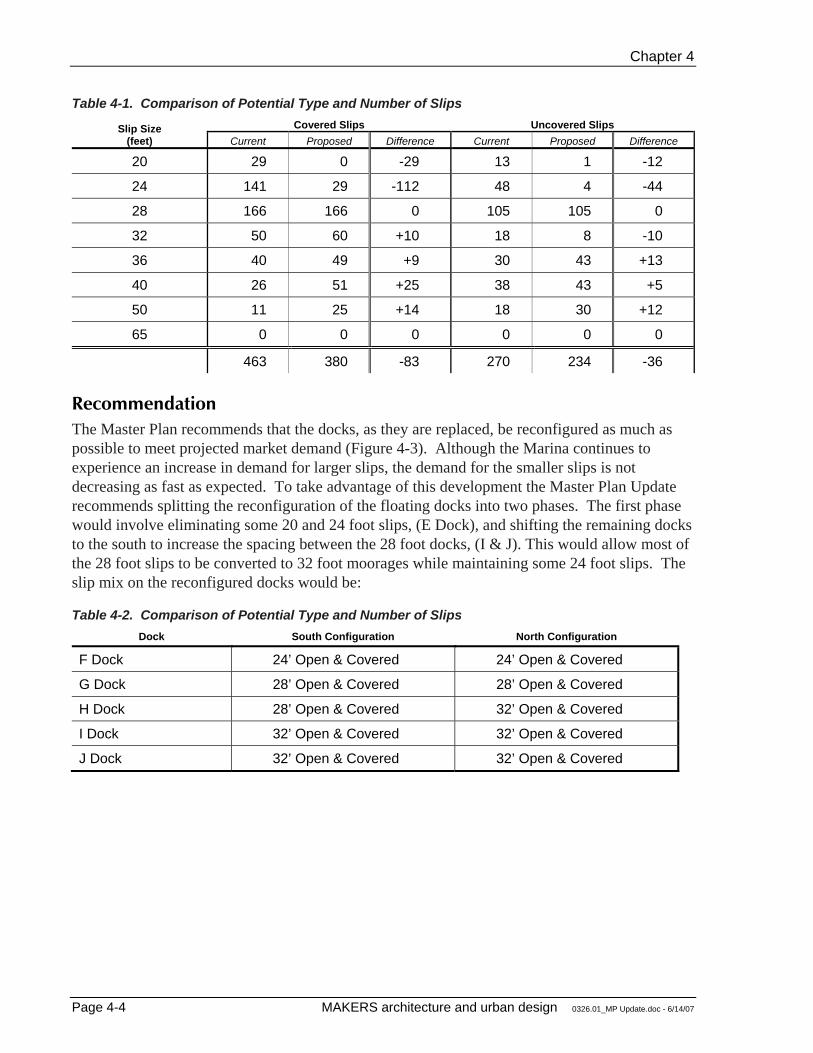
Table 4-1. Comparison of Potential Type and Number of Slips Covered Slips Uncovered Slips Slip Size
(feet) Current Proposed Difference Current Proposed Difference
20 29 0 -29 13 1 -12
24 141 29 -112 48 4 -44
28 166 166 0 105 105 0
32 50 60 +10 18 8 -10
36 40 49 +9 30 43 +13
40 26 51 +25 38 43 +5
50 11 25 +14 18 30 +12
65 0 0 0 0 0 0
463 380 -83 270 234 -36
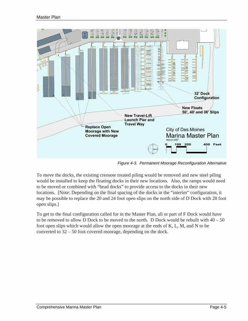
Recommendation The Master Plan recommends that the docks, as they are replaced, be reconfigured as much as possible to meet projected market demand (Figure 4-3). Although the Marina continues to experience an increase in demand for larger slips, the demand for the smaller slips is not decreasing as fast as expected. To take advantage of this development the Master Plan Update recommends splitting the reconfiguration of the floating docks into two phases. The first phase would involve eliminating some 20 and 24 foot slips, (E Dock), and shifting the remaining docks to the south to increase the spacing between the 28 foot docks, (I & J). This would allow most of the 28 foot slips to be converted to 32 foot moorages while maintaining some 24 foot slips. The slip mix on the reconfigured docks would be:
Table 4-2. Comparison of Potential Type and Number of Slips Dock South Configuration North Configuration
F Dock 24’ Open & Covered 24’ Open & Covered
G Dock 28’ Open & Covered 28’ Open & Covered
H Dock 28’ Open & Covered 32’ Open & Covered
I Dock 32’ Open & Covered 32’ Open & Covered
J Dock 32’ Open & Covered 32’ Open & Covered
Master Plan
Comprehensive Marina Master Plan Page 4-5
Figure 4-3. Permanent Moorage Reconfiguration Alternative
To move the docks, the existing creosote treated piling would be removed and new steel piling would be installed to keep the floating docks in their new locations. Also, the ramps would need to be moved or combined with “head docks” to provide access to the docks in their new locations. [Note: Depending on the final spacing of the docks in the “interim” configuration, it may be possible to replace the 20 and 24 foot open slips on the north side of D Dock with 28 foot open slips.]
To get to the final configuration called for in the Master Plan, all or part of F Dock would have to be removed to allow D Dock to be moved to the north. D Dock would be rebuilt with 40 – 50 foot open slips which would allow the open moorage at the ends of K, L, M, and N to be converted to 32 – 50 foot covered moorage, depending on the dock.
Chapter 4
Page 4-6 MAKERS architecture and urban design 0326.01_MP Update.doc - 6/14/07
Guest Moorage Facility The 2001 Master Plan explored options for expanding the guest moorage program by converting existing uplands at the north end of the Marina into new in-water moorage space. In 2001 the program was generating significant revenue for the Marina and was usually operating over capacity during summer months, making expansion a viable option for the Marina. Since that time guest moorage activity has declined by 35 percent, falling from a high of 9,367 boat nights in 2001 to 5,789 boat nights in 2005. Expansion options therefore require additional analysis to validate the economic benefits.
2001 Master Plan Recommendation Boating trends in 2001 indicated that there would be increasing demand among boaters for larger and more comfortable guest moorage facilities. By adjusting internal operations and by expanding marketing efforts, the Marina found that it could attract more families and boating clubs to the guest moorage. To better take advantage of boating trends, the guest moorage area could be expanded to increase its capacity, convenience, and desirability.
Extensive study of the guest moorage facility produced a design that enlarged the guest moorage space and retained a public boat launch. Specifically, the layout for Marina: 1) expands the guest moorage area from 1,800 to 3,200 lineal feet; 2) rotates the guest moorage floating docks so that they are parallel to the permanent moorage docks; 3) creates ample in-water queuing area for dry shed, dry stack, and public launching activity; 4) provides upland space for a reconstructed public boat launch; and 5) creates new open space areas to the east and north of the guest moorage. Presently, the guest moorage area can accommodate approximately 70 boats. As planned, the capacity of the guest moorage would increase to approximately 130 boats. The 2001 Marina Master Plan recommended this alternative.
Partial funding for guest moorage improvements may be available from the Interagency Committee for Outdoor Recreation (IAC) Boating Facilities Program. In addition, the expanded guest moorage project may be eligible for funds from the U.S. Department of Fish and Wildlife’s Boating Infrastructure Grant Program. Marina staff would aggressively pursue all grant opportunities available as a way to effectively leverage Marina funds.
In addition to the annual revenues offered by an expanded guest moorage, popular boating destinations generate positive financial impacts for the community as a whole. Local shops, restaurants, service stations, and other businesses benefit from being close to a busy marina. Des Moines residents benefit from having local businesses that are successful. As mentioned previously, the 1990 study by the Washington State Parks and Recreation Commission suggests that boaters will spend approximately $115 in local establishments each time they visit the Des Moines Marina.

Master Plan
Comprehensive Marina Master Plan Page 4-7
Figure 4-4. Recommended Changes to Guest Moorage, 2001 Marina Master Plan
Recommendation Since completion of the 2001 Master Plan the guest moorage program has experienced a significant decrease in utilization and revenue due to the continued decline in recreational salmon fishing in the Puget Sound. Improving future utilization of the guest moorage will require the Marina to more aggressively target organizations/clubs, individual or family cruisers, and other similar groups, all of which have the potential to keep the guest moorage viable. In fact, new opportunities are emerging for possibly expanding in-water guest moorage space by excavating uplands at the north end of the Marina (Figure 4-4). Given these conditions, expansion of the guest moorage program requires further economic analysis to ensure it is still a viable alternative for the Marina.
Chapter 4
Page 4-8 MAKERS architecture and urban design 0326.01_MP Update.doc - 6/14/07
Passenger Only Ferries Since the original Master Plan was adopted in 2001 there has been a renewed interest by both public and private parties in the development of a passenger-only ferry system. Initially, the interest was motivated by the desire to provide more access to island communities like Vashon Island and the San Juan Islands, or by the need to connect communities on the west side of the Sound with employment centers in Seattle, Bellevue, and Redmond. However, recent advances in boat-building technology have made moving people on the water much faster and more reliable. The advent of this new generation of passenger carrying vessels has some leaders in the public sector discussing the possibility of using passenger ferries to alleviate congestion in the land-based north-south transportation corridors.
Most of the discussions to date have included the Des Moines Marina as a potential terminal site because of it’s proximity to other modes of transportation such as Sea-Tac airport, light rail, State Highway 509, and Interstate 5. A feasibility study conducted by the Puget Sound Regional Council is scheduled for completion in 2008.
Recommendation At this time the Master Plan recommends that any changes to the Marina entrance or the guest moorage area consider the potential for a future passenger ferry terminal and that nothing be done that would preclude such a possibility.
Master Plan
Comprehensive Marina Master Plan Page 4-9
Upland Recommendations Launching Facilities There are currently three boat launching facilities maintained by the Marina, including the public sling launcher, the dry shed sling launcher, and the boat yard travel lift launch. All three facilities are nearing the end of their useful life and require some level of repair.
Recommendation The Master Plan recommends the following actions concerning launch facilities at the Marina.
Public Sling Launcher. Demolish the public sling launcher and eliminate public launch functions at the Marina. The Redondo Boat Ramp will continue to operate as a public launch in the City of Des Moines. Parking areas adjacent to the sling launcher can be restriped from car/trailer spaces to car only spaces or converted to an alternate use.
Dry Shed Sling Launcher. The dry shed launcher will continue to operate in its current capacity for the foreseeable future, providing launch capabilities for both dry shed tenants and Marina maintenance boats. As the dry sheds reach the end of their useable life this area of the Marina may be redeveloped. At that time the dry shed launcher may be eliminated.
Travel Lift Launch. Demolish the existing travel lift launch and construct an expanded facility for use by the boat yard capable of accommodating boats up to 55 feet in length. The new travel lift pier would be located between Docks M and N (existing travel lift is between Docks L and M) and would be aligned with the fairway to facilitate launch operations. This location was selected because it would allow the existing travel lift to remain in operation while the new facility is built. This is an operational necessity for the boat yard. Impacts to the inside slips would be minimized by setting the launch slightly back into the shoreline. Approximately one-quarter of the dry sheds would be demolished to provide necessary maneuvering space. Demolition of these sheds and bulkhead preparations for the new travel lift launch are included under Phase I of the bulkhead replacement project.
Harbormaster Building The Harbormaster Building currently houses the Harbormaster offices and Marina Maintenance Shops. Given the building’s location on the central waterfront it is an extremely valuable asset for the Marina.
Recommendation The Master Plan recommends relocation of the Marina Maintenance Shops to an alternate location, remodeling the Harbormaster offices, and relocating public restroom facilities to the first floor. Laundry / shower facilities would also be incorporated.
Chapter 4
Page 4-10 MAKERS architecture and urban design 0326.01_MP Update.doc - 6/14/07
Boat Yard CSR Marine is constrained by the size of their boat yard and travel lift pier. They have expressed an interest in expanding their current business to accommodate larger boats, possibly up to 60 feet in length.
Recommendation The Master Plan recommends construction of a new and expanded boat yard near the existing facility. The new building will be approximately 4,000 square feet. A temporary boat yard will be sited to the south of the existing yard so that the business can remain in operation during construction. Upon completion, the outdoor yard will be approximately 18,000 square feet. A new travel lift launch pier is also included, as described above.
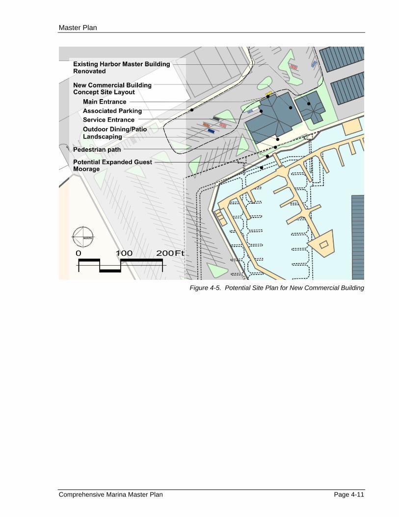
Commercial Building Several options have been explored for the construction of a new commercial building to the area north of the Harbormaster building. These options were developed to capitalize on growing opportunities for increased commercial development on the Marina floor.
Recommendation A new commercial building is recommended on the waterfront immediately north of the Harbormaster building. Further analysis is required, but at this time the structure is being sized as a one-story building with a footprint of approximately 6,000 square feet. Possible uses include a restaurant or a deli / small scale grocer. The project provides the building and site improvement, as well as a 1,500 square foot deck area that uses the existing bulkhead alignment fronting the building. Associated parking requirements can be accommodated within the existing north parking lot. Options for connecting the new structure to the Harbormaster building should also be explored to provide the Harbormaster offices with elevator access.
Financing options for the building require additional analysis to identify the best option for the City. The City could construct and lease the building or undertake a ground lease with a private developer who would construct and lease the building. Advantages of entering into a ground lease include lower capital requirements for the City and better financial performance.
Master Plan
Comprehensive Marina Master Plan Page 4-11
Figure 4-5. Potential Site Plan for New Commercial Building
Chapter 4
Page 4-12 MAKERS architecture and urban design 0326.01_MP Update.doc - 6/14/07
Marine Retail Opportunities may exist to open a small scale marine retail / hardware store to support Marina’s boating community. Real estate is available for this use south of the boatyard.
Recommendation Locating a marine hardware business along the Marina waterfront would be a positive addition. A new marine hardware retail building is therefore recommended on the waterfront immediately south of the expanded boat yard being proposed. The proposed 4,000 square foot building is a one-story prefabricated steel/CMU structure with store front and loading dock. The project includes parking lot improvements and landscaping.
Financing options for the new marine retail building require additional analysis to identify the best option for the City. The City could construct and lease the building or undertake a ground lease with a private developer who would construct and lease the building. Advantages of entering into a ground lease include lower capital requirements for the City and better financial performance.
Marina Maintenance Shops Marina maintenance shops are currently located on the ground floor of the Harbormaster building. This function does not need to be located on the central waterfront and is a poor use of this space.
Recommendation The Master Plan recommends constructing a new marina maintenance shop on the Quartermaster Parcel located against the bluffs at the back of the Marina within the existing 223rd Street right-of-way. A 1,050 square foot, one-story maintenance building with mezzanines would meet maintenance shop needs. Relocation of the maintenance function will allow a more appropriate use to occupy the first floor of the Harbormaster building.
Large Boat Storage Yard There is an opportunity to provide a dry boat storage yard where the current dry shed buildings are located. Boats up to 50 feet long could be stored on trailers within the secured storage yard. Demand for this type of “moorage” is increasing both around the Puget Sound and nationally. Depending on the size of the boats and the type of trailers or dollys used to store the boats on, the area could accommodate 24 to 36 large boats. The travel lift that was purchased through the Federal surplus Property Program could be used to retrieve and launch boats from the new travel lift pier that is proposed for the M – N Dock water way. Site improvements such as water lines, electric power boxes and thicker pavement for the travel lift’s travel path to accommodate the heavy wheel loads would be necessary.
Recommendation Continue to explore opportunities for upland boat storage as other improvements are implemented on the Marina floor.
Master Plan
Comprehensive Marina Master Plan Page 4-13
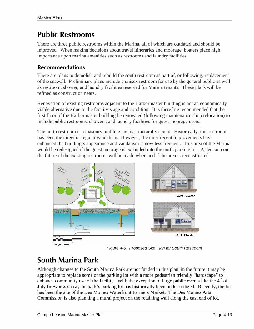
Public Restrooms There are three public restrooms within the Marina, all of which are outdated and should be improved. When making decisions about travel itineraries and moorage, boaters place high importance upon marina amenities such as restrooms and laundry facilities.
Recommendations There are plans to demolish and rebuild the south restroom as part of, or following, replacement of the seawall. Preliminary plans include a unisex restroom for use by the general public as well as restroom, shower, and laundry facilities reserved for Marina tenants. These plans will be refined as construction nears.
Renovation of existing restrooms adjacent to the Harbormaster building is not an economically viable alternative due to the facility’s age and condition. It is therefore recommended that the first floor of the Harbormaster building be renovated (following maintenance shop relocation) to include public restrooms, showers, and laundry facilities for guest moorage users.
The north restroom is a masonry building and is structurally sound. Historically, this restroom has been the target of regular vandalism. However, the most recent improvements have enhanced the building’s appearance and vandalism is now less frequent. This area of the Marina would be redesigned if the guest moorage is expanded into the north parking lot. A decision on the future of the existing restrooms will be made when and if the area is reconstructed.
Figure 4-6. Proposed Site Plan for South Restroom
South Marina Park Although changes to the South Marina Park are not funded in this plan, in the future it may be appropriate to replace some of the parking lot with a more pedestrian friendly “hardscape” to enhance community use of the facility. With the exception of large public events like the 4th of July fireworks show, the park’s parking lot has historically been under utilized. Recently, the lot has been the site of the Des Moines Waterfront Farmers Market. The Des Moines Arts Commission is also planning a mural project on the retaining wall along the east end of lot.
Chapter 4
Page 4-14 MAKERS architecture and urban design 0326.01_MP Update.doc - 6/14/07
Upland Circulation and Parking Vehicular Circulation Vehicular access to the Marina is from South 227
th Street and Cliff Avenue. Internal traffic lanes
provide access to the various Marina facilities. The primary north-south roadway (formerly Dock Street) connects the north and south entrances. This roadway is near the east property line and is not always clearly delineated from adjacent parking areas and pathways. The internal connection of the two entrances exacerbates weekend “cruising” through the Marina. Speeding along this route led to the installation of numerous speed bumps.
Recommendations The Marina was designed to accommodate visitors and patrons arriving by automobile. The Master Plan acknowledges and preserves this critical access while recommending improved pedestrian and bicycle access.
In particular, the Master Plan recommends the following:
Vehicular circulation and parking modifications will be required in the north Marina if / when the new commercial building is constructed. Site specific modifications will be worked out when the project goes to construction.
In the south parking lot, north-south traffic will be limited to the east area of the Marina. A new, centrally sited restroom building will be located between the parking and the bulkhead promenade. This will allow for vehicular access to parking and businesses, but will discourage automobile traffic adjacent to the bulkhead.
In the south parking lot, curbing, landscaped areas, and a raised sidewalk/bike path will define the north-south roadway near the east property line. This will give the roadway an appearance similar to a public street.
Presently, a security gate at the north entrance is closed and locked at 10:00 p.m. each evening. The Master Plan recommends this gate be replaced with an electronic gate that will allow after-hours access by residents of the Des Moines Mariner Condominiums.
Pedestrian Circulation The Marina is located within Des Moines’ downtown, and walkers regularly “loop” through the Marina. Many pedestrians enjoy the sights and activities of the Marina all year around. It is also a focal point for the community and an important open space.
Sidewalks exist along both South 227th Street and Cliff Avenue and provide pedestrian access to the Marina at both entrances. A new pedestrian route is included within the WestPointe Condominium development at approximately 6th Avenue South and 225th Street.
Master Plan
Comprehensive Marina Master Plan Page 4-15
The pedestrian path along the bulkhead in the south parking lot is paved with asphalt and separated from vehicular traffic by extruded concrete curbing. In the north parking lot, there is a raised concrete sidewalk along the seawall. Although many people walk along the east edge of the Marina, there are no pedestrian facilities there.
Recommendations Pedestrian space is a premium asset within the Marina and needs to be protected. The Master Plan recommends improving the pedestrian facilities and amenities within the Marina, including:
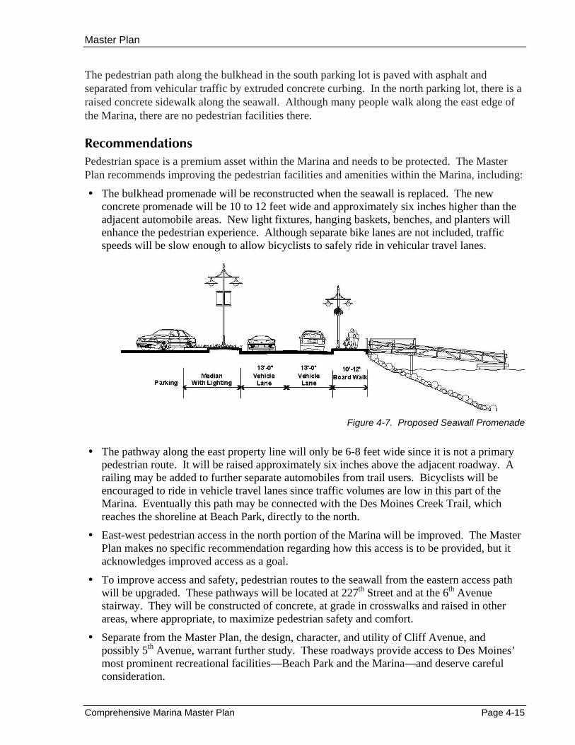
The bulkhead promenade will be reconstructed when the seawall is replaced. The new concrete promenade will be 10 to 12 feet wide and approximately six inches higher than the adjacent automobile areas. New light fixtures, hanging baskets, benches, and planters will enhance the pedestrian experience. Although separate bike lanes are not included, traffic speeds will be slow enough to allow bicyclists to safely ride in vehicular travel lanes.
Figure 4-7. Proposed Seawall Promenade
The pathway along the east property line will only be 6-8 feet wide since it is not a primary pedestrian route. It will be raised approximately six inches above the adjacent roadway. A railing may be added to further separate automobiles from trail users. Bicyclists will be encouraged to ride in vehicle travel lanes since traffic volumes are low in this part of the Marina. Eventually this path may be connected with the Des Moines Creek Trail, which reaches the shoreline at Beach Park, directly to the north.
East-west pedestrian access in the north portion of the Marina will be improved. The Master Plan makes no specific recommendation regarding how this access is to be provided, but it acknowledges improved access as a goal.
To improve access and safety, pedestrian routes to the seawall from the eastern access path will be upgraded. These pathways will be located at 227th Street and at the 6th Avenue stairway. They will be constructed of concrete, at grade in crosswalks and raised in other areas, where appropriate, to maximize pedestrian safety and comfort.
Separate from the Master Plan, the design, character, and utility of Cliff Avenue, and possibly 5th Avenue, warrant further study. These roadways provide access to Des Moines’ most prominent recreational facilities—Beach Park and the Marina—and deserve careful consideration.
Chapter 4
Page 4-16 MAKERS architecture and urban design 0326.01_MP Update.doc - 6/14/07
Parking The number of parking spaces within the Marina generally accommodates present demand. Existing on-site parking is located as follows:
South of Boat Yard 338 single vehicle spaces 18 vehicle-trailer spaces North of Boat Yard 82 single vehicle spaces 84 vehicle-trailer spaces Total Existing Parking 522 spaces
Recommendation The Master Plan proposes reconfiguring the existing parking area to increase the number of single-vehicle spaces. Vehicle-trailer combination spaces will no longer be required since the public sling launcher will be demolished. At the same time, the construction of new commercial spaces and potential enlargement of the guest moorage will increase the need for single-vehicle parking. Reconfiguration of trailer parking areas will yield the following number of spaces:
South Parking Lot 467 single vehicle spaces 0 vehicle-trailer spaces North Parking Lot 156 single vehicle spaces 0 vehicle-trailer spaces Total Proposed Parking 623 spaces
The above recommendation is based upon estimates using information available at this master planning stage. As more detailed site plans are prepared, the exact number of each type of parking space can be determined. The requirements for off-street parking, according to the Des Moines Municipal Code (Chapter 18.44 DMMC), are as follows:
Use Parking Requirement
Boat Moorage 1 space per 2 slips Retail 1 space per 350 square feet Office with Customer Service 1 space per 350 square feet Office without Customer Service 1 space per 800 square feet Restaurant 1 space per 125 square feet Boat Repair 1 space per 600 square feet Dry Storage None specified Public Boat Launch None specified Fishing Pier 52 spaces (IAC Agreement) Shared-Use Allowance 20 percent reduction
The on-site parking proposed by the draft site plan satisfies Code requirements. Based on a parking utilization survey conducted on Saturday, September 12, 1998, this parking allowance would be adequate to accommodate demand.
Comprehensive Marina Master Plan Page 4-17
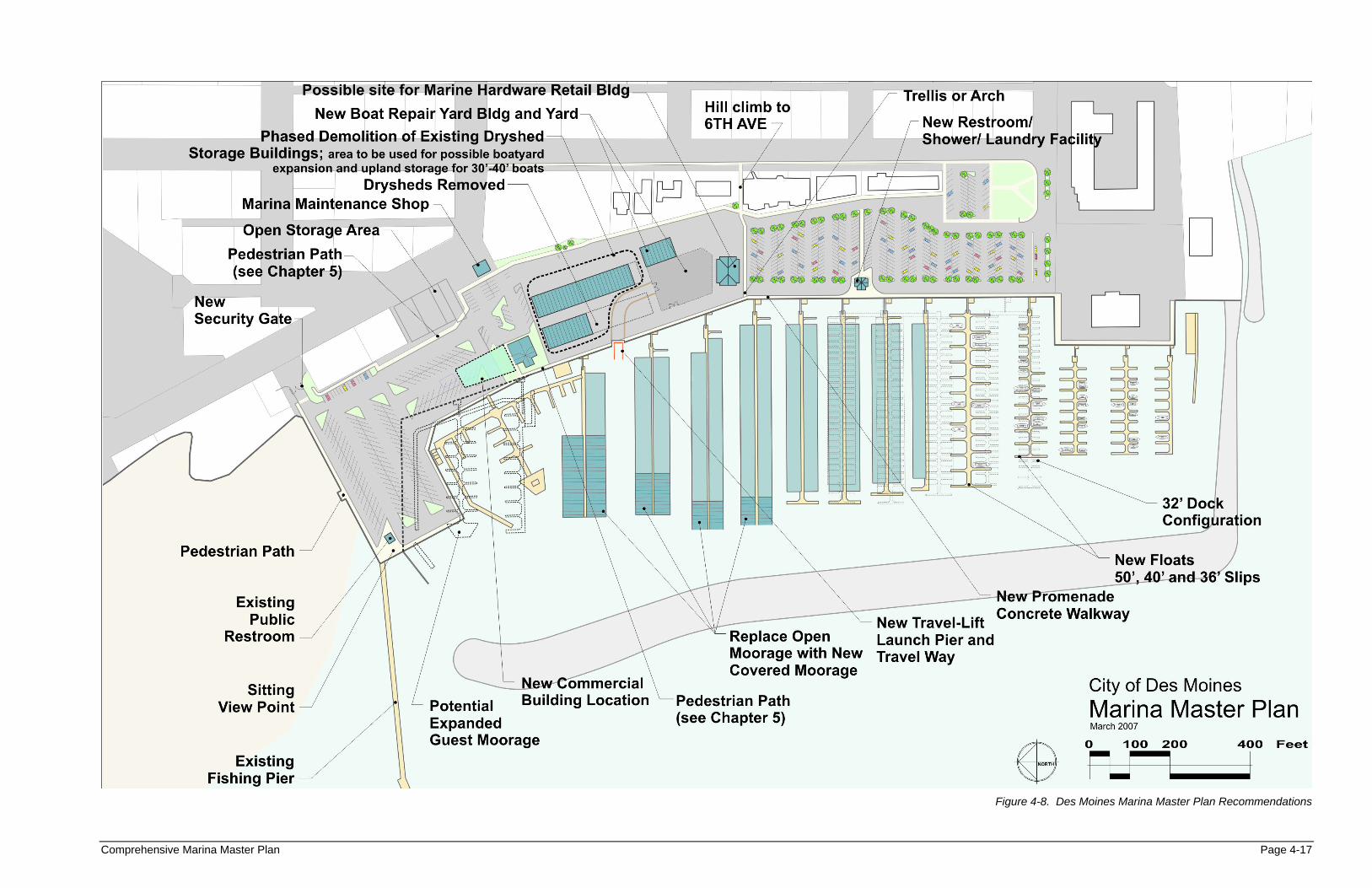
Figure 4-8. Des Moines Marina Master Plan Recommendations


![[4] - Noise Moines, Iowa.pdf · 6/11/2016 Des Moines, IA Code of Ordinances](https://img.pdfslide.us/doc/110x75/60110284a0cad57a063f2773/4-noise-moines-iowapdf-6112016-des-moines-ia-code-of-ordinances.jpg)