Embed Size (px)
Citation preview
1
Astronomical interpretation of a Palaeolithic rock carving found at Sopor, Kashmir1
M N Vahia1, Aijaz A Banday2, Mumtaz Ahmad Yatoo2
Naseer Iqbal3, Tabasum Masood Bhat3, 1Tata Institute of Fundamental Research, Mumbai
2Centre of Central Asian Studies, University of Kashmir, Srinagar 3Department of Physics, University of Kashmir, Srinagar
Abstract: We analyse a rock carving found in Bomai-Sopor, north of Kashmir, first reported by Banday (2003) and described by Yatoo (2005). The details of the carving and comparison with the geographical features of the region show how several components of it agree with the local geophysical morphology. An interpretation of the carving based on comet shower and astronomy seems a very likely one for which some tests are to be conducted to check this interpretation. Introduction Palaeolithic people have used stone carvings and rock paintings to express themselves as well as to record their impressions of the real world, particularly from the Upper Palaeolithic times which generally speaking begain around 40,000 years before present with the emergence of the Homo sapiens. There are certain situations when the art was also found in the late stages of the Middle Palaeolithic period also. Most of the times these are said to have been made to show the heightened passion of man in search of food as mostly these have representations of hunting scenes. Amongst these are also found the symbols of sun or moon – the celestial bodies as in the carving in Kashmir. A stone carving found in Burzahom, Kashmir depicting a hunting scene has recently been interpreted as a recording of Supernova that happened about 7000 years before present (Joglekar et al., 2006). In the present paper, we suggest that the stone carving found in Sopor, Kashmir has likely astronomical origin. Considering that both the stone carvings were found within a distance of 70 km and, therefore, are indicative of a tradition of recording astronomical events in the region, even though both the events took place thousands of years from each other. Stone carving The rock carving was found near Bomai in Sopor area of Kashmir, about 70 km north west of Srinagar. Yatoo (2005) in his archaeological work has described that the carving has multiple concentric circles distributed all over the scene which also has animal and human figures, including some masked ones (Figure 1 a and 1 b). The carving on the face of a mountain, at a height of about 100 meters from the fields below is located at a place which overlooks the famous Wular Lake in its north east. The engraved area on the rock measures 1x1 meter and its left top points to the north west direction.
1 To appear in Puratatva (Journal of Indian Archaeological Society), 2006
2
Figure 1a A stone carving at Sopor. The top left marks the North West direction.
3
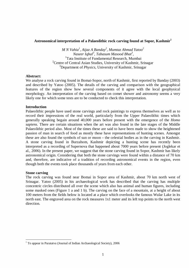
Figure 1 b Sketch of the rock carving by Mumtaz Yatoo, having 4 major circles marked A to D while E marks 2 smaller circles.
A
B
C
D E
4
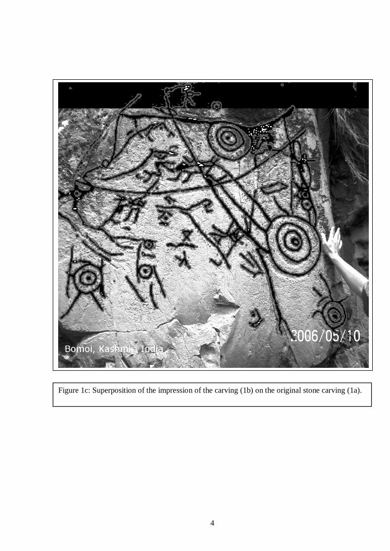
A
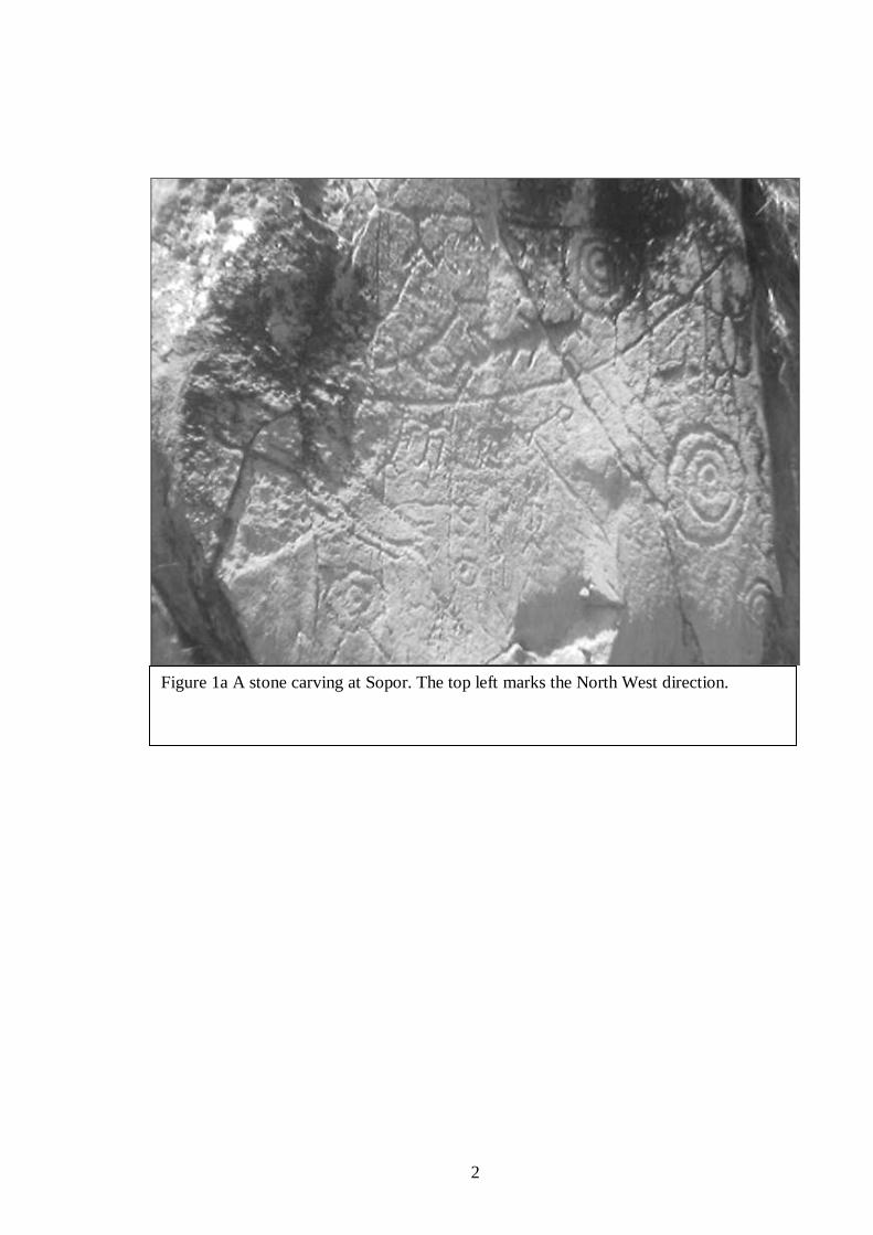
Figure 1c: Superposition of the impression of the carving (1b) on the original stone carving (1a).
5
Given the studies conducted recently on the Burzahom carving the scene portrayed on the Sopor carving depicts an astronomical event. In that case the total scene depicts a comet impact sequence. There are several reasons to suggest this to be the case. We would like to emphasize that while the carving itself has been scaled; the relative size and location of all the components of it have been left unaltered. We list the reasons below:
1) There are multiple circles, all of concentric nature. This is typical of how bright objects are shown in stone carvings. In such carvings, the size of the circle is indicative of its brightness.
2) The circles are not drawn in any specific geometric or other pattern and appear random. The
distributions of the size of circle also do not admit of any obvious pattern. 3) The largest circle (circle B in figure 1 b) has lines emanating from it only in one direction. (A
close look at the stone carving indicates that the solo line shown in the sketch in opposite direction seems incorrect). Two other circles (C and D in figure 1 b) have only small lines in random directions. The number of lines coming out is small and seems to change directions. The lines for C seem to come from the same direction to that of B while those on D seem to come from either side. We suggest that this is an indication of the movement of the object or a light streak.
4) The rock carving is on the mountain and could not have moved since its make. Artefacts
surrounding the site have been dated to the Upper Palaeolithic period and the region was also inhabited during the Neolithic period dated around 5,000 BP ( Yatoo 2005).
5) The manner of location of the rock indicates that the objects originate in the sky in the North
West direction and fall towards South East direction. The first, second and fourth largest rings are collinear in this direction. Two lines are drawn around the D and E rings. We assume that these lines indicate their path of motion. If so, all the paths seem to meet at the top of the rock.
6) The two horizontal lines on the carving coincides the line of flow of Jehlum River and the
upper line coincides with the edge of mountain range from which the valley begins.
7) The location D most appropriately corresponds to the Nilenag, which is the source of River Dood Ganga located in the west of Srinagar. Nag in Kashmiri means a large or small spring and the larger ones are the sources of rivers like Verinag for river Jhelum, likewise Sheshnag for river Lidder. Such large nags are lake like as Sheshnag is a large water body forming a trough like formation as is the case with Nilenag.
8) The map is not a geographical map of lakes since there is no lake on the location of the circle
marked D the figure 1b and the broken mountain seen in that region could not have been known to the ancients. What does this mean we have not yet talked about the lakes etc
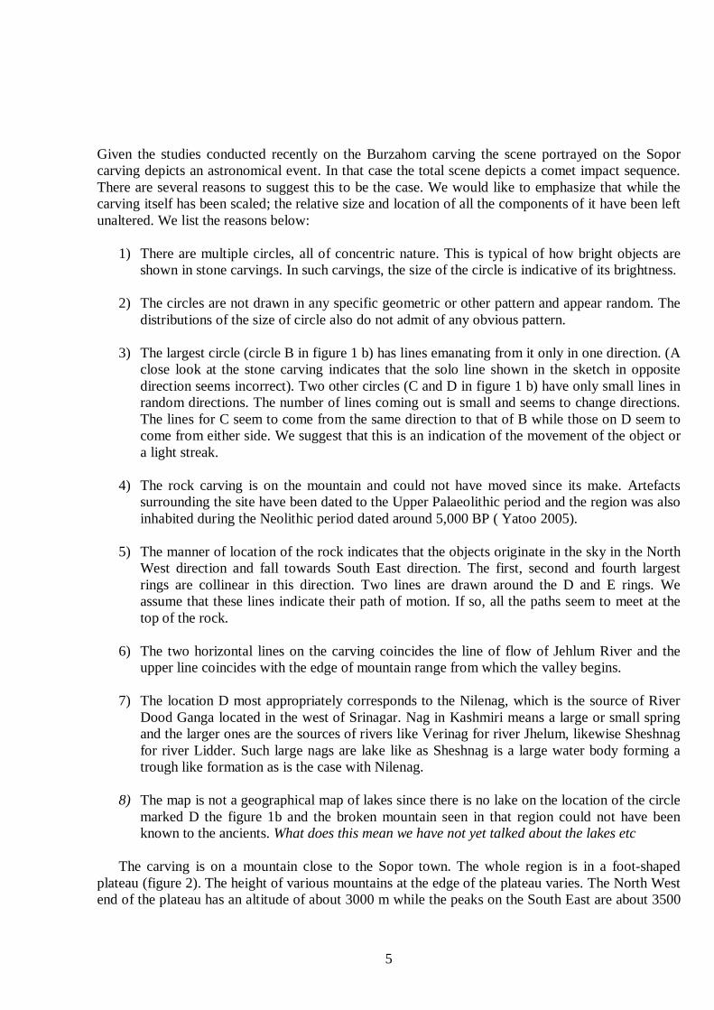
The carving is on a mountain close to the Sopor town. The whole region is in a foot-shaped
plateau (figure 2). The height of various mountains at the edge of the plateau varies. The North West end of the plateau has an altitude of about 3000 m while the peaks on the South East are about 3500
6
meters. The valley of Kashmir is about 1700 meters above mean sea level and its length is 152 km and the width is about 40 km.
The astronomical observations reveal that the carving is that of a meteor shower that was witnessed some time between the Upper Palaeolithic and the Neolithic periods in the area (40,000 and 5,000 BP), and the artist/s must have found this spectacular astronomical event to record it on the rock. He would have found that a single piece of meteor splintered into several small pieces as it entered the atmosphere. The bigger pieces could have landed in full and, if so, these would have created crater pits and lakes. On the other hand, the carving cannot be a geographical map of the region since it requires a great leap of imagination (or access to a good map) to realise the complexity of the geography, which runs well over the horizon and is not visible from a single vantage point. Also, the relative geographical spread of the lakes is not directly related to the sizes of the circles but seems to correspond to the depth of a lake, a measure not available to the artists of the deep past. The event recorded seems to be significant since:
1) It is the only rock carving found in the area otherwise very rich in Palaeolithic and Neolithic
sites. 2) The location of the rock is such as to indicate the backdrop of the seat of a ‘high priest’ with
space for the ‘subjects’ at a lower level from which the carving would be clearly visible over the head of a priest of normal height.
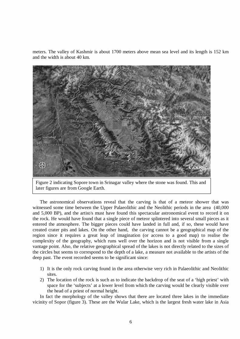
In fact the morphology of the valley shows that there are located three lakes in the immediate vicinity of Sopor (figure 3). These are the Wular Lake, which is the largest fresh water lake in Asia
Figure 2 indicating Sopore town in Srinagar valley where the stone was found. This and later figures are from Google Earth.
7
and can be taken to have arisen from the topmost circle (A in figure 1 b). The second circle, (B in figure 1 b) would have formed the Mansbal Lake and the third circle (C in figure 1 b) could have formed the Dal Lake. Circle D in figure 1 b has no corresponding lake and it is possible that this rock hit a mountain and did not cause a lake formation.
We suggest that being an example of early human rock carving, the sketch is not to scale. The human figures, therefore, are indicative of human presence and some shapes like an apparent crossroad to the West of rings B may be indicative of a human habitation. In figure 3b we superpose the carving of stone carving (1b) on the geography of the region.
Figure 3a: Location of various lakes in the region. The largest Wular Lake is at the top. To the South East of it is the boomerang shaped Mansbal Lake. Close to Srinagar is the Dal Lake. All three are roughly collinear towards South East from the location of the stone, which is roughly on the hill on the top left region of the figure. There are other smaller water bodies (indicated by blue closed curves). Two major ones fall on the line of Wular and Dal lake while other smaller ones are farther south. The yellow circle on the top marks the location of the stone.
8
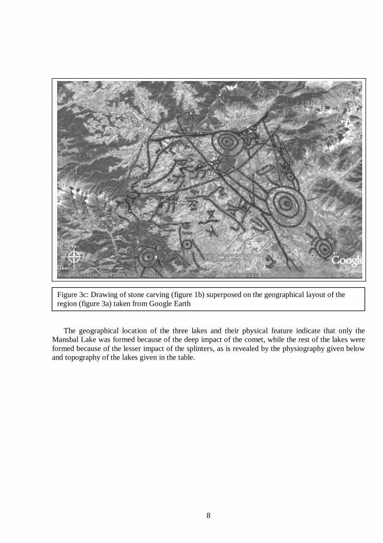
The geographical location of the three lakes and their physical feature indicate that only the Mansbal Lake was formed because of the deep impact of the comet, while the rest of the lakes were formed because of the lesser impact of the splinters, as is revealed by the physiography given below and topography of the lakes given in the table.
Figure 3c: Drawing of stone carving (figure 1b) superposed on the geographical layout of the region (figure 3a) taken from Google Earth
9
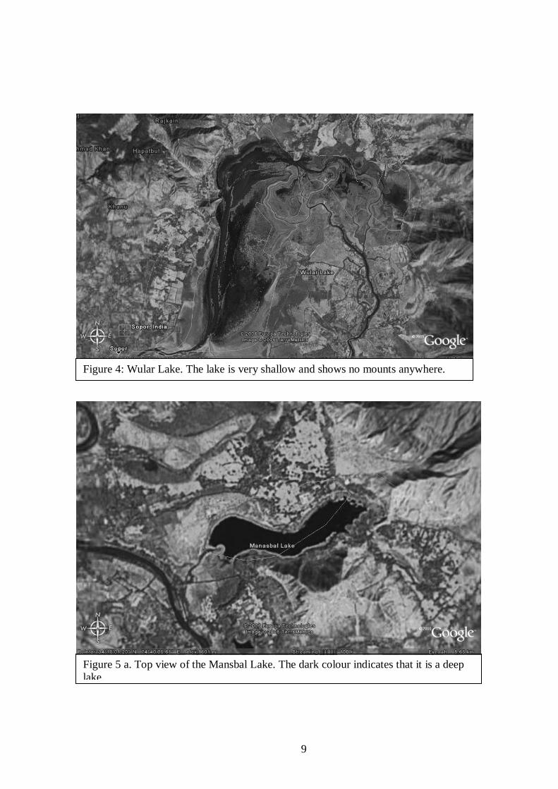
Figure 4: Wular Lake. The lake is very shallow and shows no mounts anywhere.
Figure 5 a. Top view of the Mansbal Lake. The dark colour indicates that it is a deep lake.
10
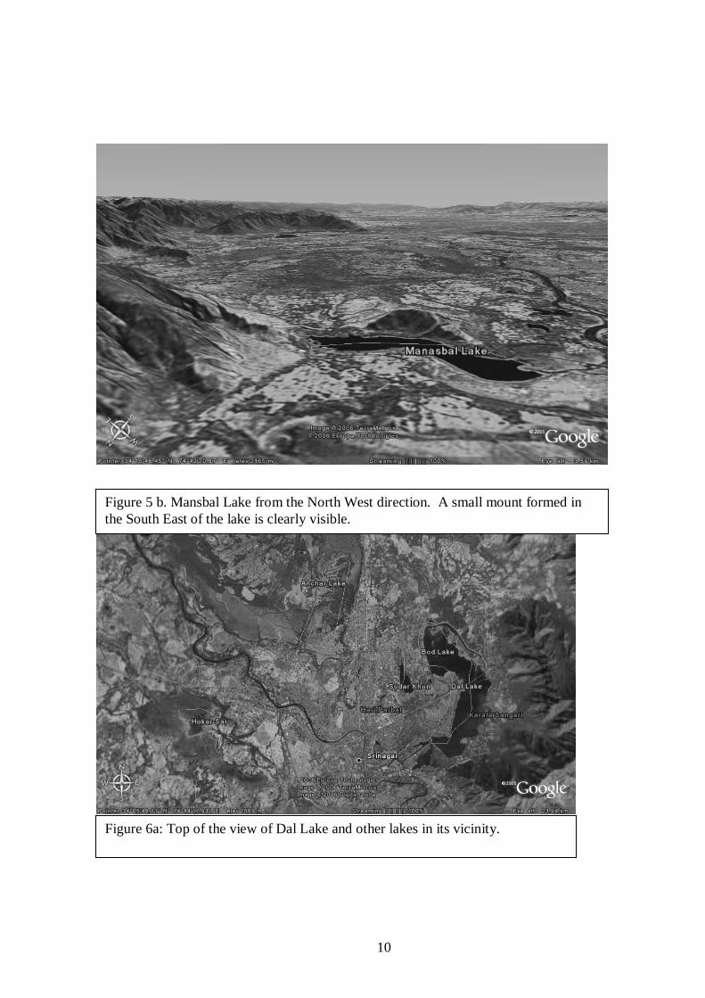
Figure 5 b. Mansbal Lake from the North West direction. A small mount formed in the South East of the lake is clearly visible.
Figure 6a: Top of the view of Dal Lake and other lakes in its vicinity.
11
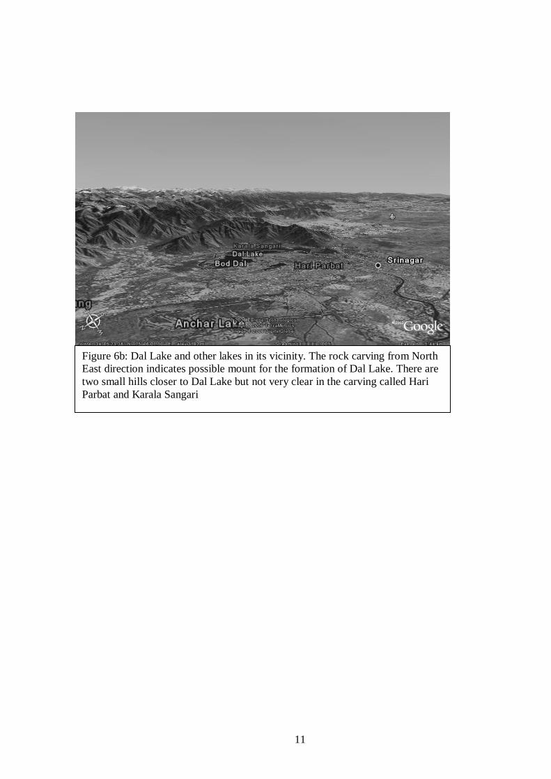
Figure 6b: Dal Lake and other lakes in its vicinity. The rock carving from North East direction indicates possible mount for the formation of Dal Lake. There are two small hills closer to Dal Lake but not very clear in the carving called Hari Parbat and Karala Sangari
12
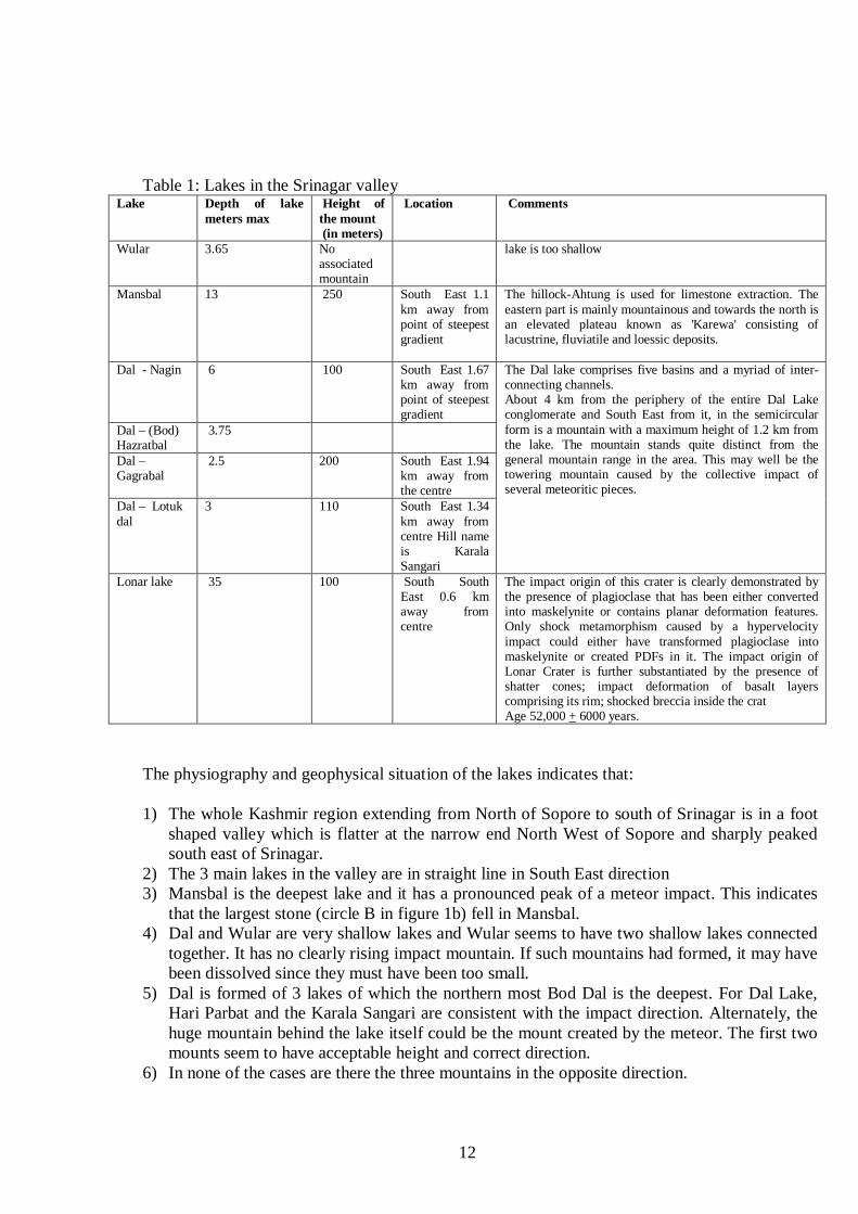
Table 1: Lakes in the Srinagar valley Lake
Depth of lake meters max
Height of the mount (in meters)
Location Comments
Wular 3.65 No associated mountain
lake is too shallow
Mansbal 13 250 South East 1.1 km away from point of steepest gradient
The hillock-Ahtung is used for limestone extraction. The eastern part is mainly mountainous and towards the north is an elevated plateau known as 'Karewa' consisting of lacustrine, fluviatile and loessic deposits.
Dal - Nagin 6 100 South East 1.67 km away from point of steepest gradient
Dal – (Bod) Hazratbal
3.75
Dal – Gagrabal
2.5 200 South East 1.94 km away from the centre
Dal – Lotuk dal
3 110 South East 1.34 km away from centre Hill name is Karala Sangari
The Dal lake comprises five basins and a myriad of inter- connecting channels. About 4 km from the periphery of the entire Dal Lake conglomerate and South East from it, in the semicircular form is a mountain with a maximum height of 1.2 km from the lake. The mountain stands quite distinct from the general mountain range in the area. This may well be the towering mountain caused by the collective impact of several meteoritic pieces.
Lonar lake 35 100 South South East 0.6 km away from centre
The impact origin of this crater is clearly demonstrated by the presence of plagioclase that has been either converted into maskelynite or contains planar deformation features. Only shock metamorphism caused by a hypervelocity impact could either have transformed plagioclase into maskelynite or created PDFs in it. The impact origin of Lonar Crater is further substantiated by the presence of shatter cones; impact deformation of basalt layers comprising its rim; shocked breccia inside the crat Age 52,000 + 6000 years.
The physiography and geophysical situation of the lakes indicates that:
1) The whole Kashmir region extending from North of Sopore to south of Srinagar is in a foot
shaped valley which is flatter at the narrow end North West of Sopore and sharply peaked south east of Srinagar.
2) The 3 main lakes in the valley are in straight line in South East direction 3) Mansbal is the deepest lake and it has a pronounced peak of a meteor impact. This indicates
that the largest stone (circle B in figure 1b) fell in Mansbal. 4) Dal and Wular are very shallow lakes and Wular seems to have two shallow lakes connected
together. It has no clearly rising impact mountain. If such mountains had formed, it may have been dissolved since they must have been too small.
5) Dal is formed of 3 lakes of which the northern most Bod Dal is the deepest. For Dal Lake, Hari Parbat and the Karala Sangari are consistent with the impact direction. Alternately, the huge mountain behind the lake itself could be the mount created by the meteor. The first two mounts seem to have acceptable height and correct direction.
6) In none of the cases are there the three mountains in the opposite direction.
13
7) There are several small water bodies, all consistent with multiple fragments especially the fragments E shown in figure 1b.
8) If the assumptions made here are correct, then the top hooded character in figure 1 b roughly marks the site of the stone relative to the lakes.
9) The horizontal curved line could indicate the river running from the Wular Lake to the West. 10) Morphology of the region around Baramulla is consistent with a meteor hitting the mountains
at Baramulla. The area where Jehlum leaves from the Valley (marked Azad Kashmir in figure 2) the mountains, the rocks and soils are loose and are very ductile. They differ in this respect with other mountains. The mountains are famous quarrying sites particularly the soil of these mountains for levelling roads, etc.
11) We disregard the possibility that this is a geographical map by the fact that the circles D in figure 1b does not correspond to a lake but a destroyed mountain, a fact that the ancient artists could not have known.
All this seems consistent with the impact crater idea. What is not consistent is that there is no
lake or pronounced impact area corresponding to the circle D in the bottom left in the carving.
In order to verify this, the following things need to be done: 1) Confirm that all the 3 lakes were formed at the same time, most probably around 30,000 +
10,000 BC, but relatively within 1 year of each other and after the Prehistoric Valley Lake was drained around 85,000 years ago that was 1.2 kms deep.
2) The angle of the lake cone and its height to distance of the deepest part of the lake should be the same within errors.
3) If the cones of the lake shape are extrapolated back, they should roughly meet in a point.
4) The relative angular separation of the various lake angles should be similar to the angles of
separation of the circles on stones.
5) It may also be useful to study soil samples from the proposed mountains and the lake beds. The lakebed will have different composition than other parts of the valley.
6) If the meteor D in figure 1 b hit a mountain then there should be some signs of it. A mountain
of loose rocks or at least some loose rock on mountains surrounding the place where we suspect the fourth piece had hit the ground should be present. These rocks will have a different morphology from the mountain itself indicating that they were thrown there later rather than being a part of the original mountain.
14
`
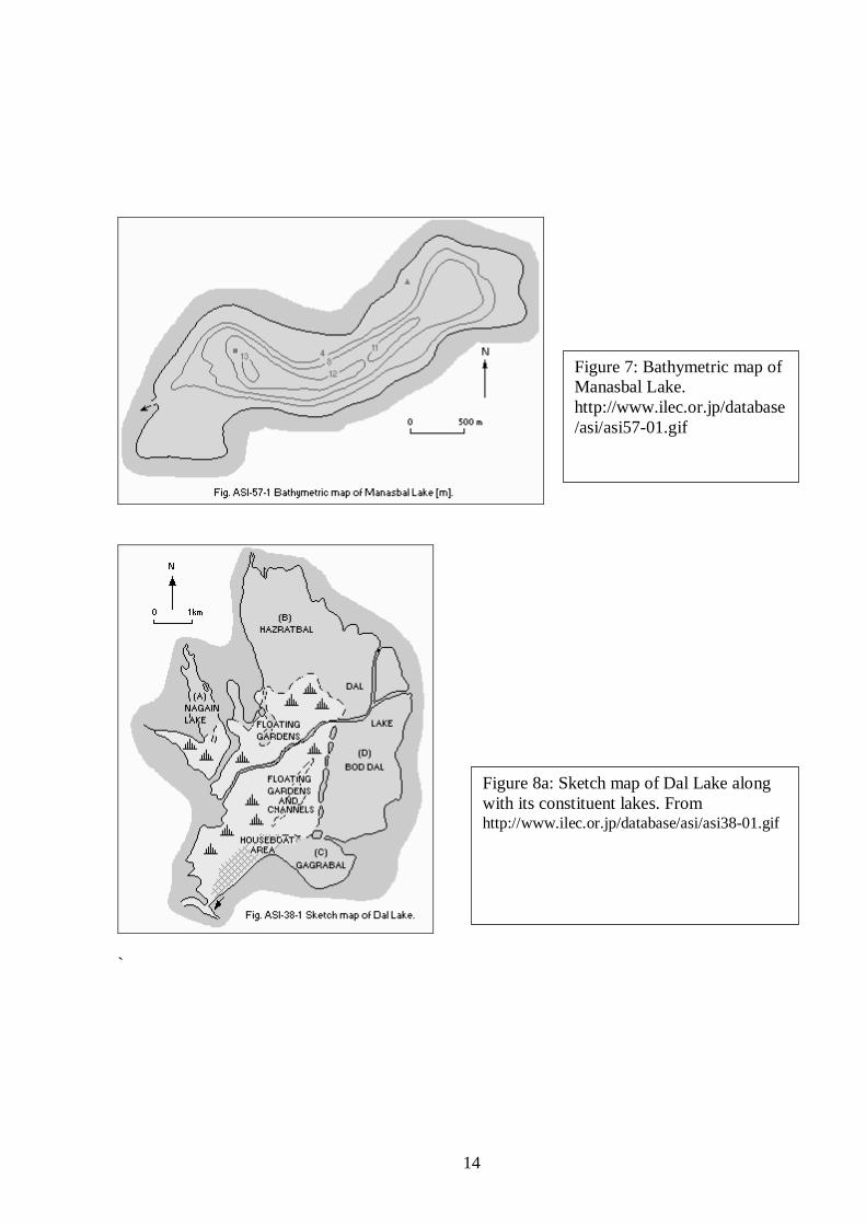
Figure 7: Bathymetric map of Manasbal Lake. http://www.ilec.or.jp/database/asi/asi57-01.gif
Figure 8a: Sketch map of Dal Lake along with its constituent lakes. From http://www.ilec.or.jp/database/asi/asi38-01.gif
15
Reference
1) Joglekar et a., 2006, submitted to IJHS. 2) Banday Aijaz, Archaeological explorations in Bomai village, Sopor, Central Asian Digest,
Vol XXIII, 2003. 3) Yatoo Mumtaz, Archaeological Explorations of Sopor and Bandipora, Kashmir, a pre-
doctoral thesis submitted to the University of Kashmir, Srinagar, 2005.
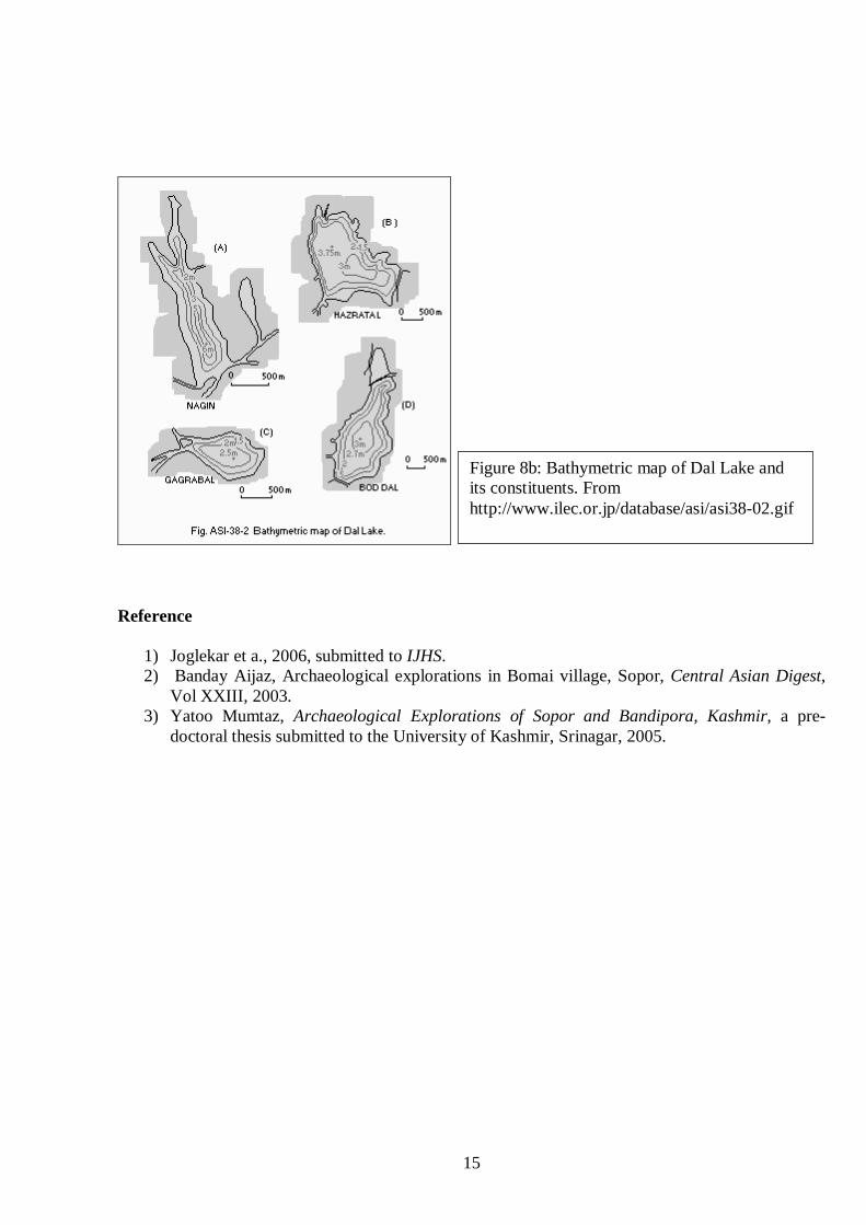
Figure 8b: Bathymetric map of Dal Lake and its constituents. From http://www.ilec.or.jp/database/asi/asi38-02.gif