Embed Size (px)
Citation preview

1
2008 Summer Edition
Fifty States Initiative: North Carolina Conducts GIS Study
North Carolina is an active participant in the fifty States initiative. North Carolina possesses eight of the nine critical characteristics of a successful geospatial coordination program. The identified deficiency is the lack of sustainable funding. The North Carolina legislature must have known because they directed that a study of Geographic Information Systems be conducted.
While North Carolina has made significant strides in creating a spatial data infrastructure, there are several areas where improvements can be made. The report says:
More effective and efficient GIS in the State of North Carolina will drive more commerce to the State. It will allow North Carolina to manage environmental challenges better which includes water quantity and quality assessments and land use planning. GIS will also help provide the best response with Emergency Services and Public Safety.
It is critical for North Carolina to act now and enable GIS to be used to its fullest potential. The growth of the State over the next twenty-five years is going to be significant. The longer the State lags in moving ahead with concentrated GIS initiatives, the further behind North Carolina will become. The backlog of outdated and unusable data layers will grow which could potentially impede North Carolina’s growth and could catch North Carolina off guard as it did with the acknowledgement of out dated flood maps in eastern North Carolina brought to light by Hurricane Floyd. Therefore,
more collaboration and cooperation is needed along with greater investment, allocated more efficiently than at the present time. Investment in GIS today will help ensure North Carolina’s prosperity and high quality of life.
The study conducted a survey of GIS related activities across the state. It used the GIS inventory tool developed by National States Geographic Information Council, a key partner in the Fifty States Initiative. The inventory found that within state agencies there were 175 dedicated full time equivalents supporting GIS operations, at a cost of $12 million. It found one of the largest challenges facing geospatial data users was locating and then ensuring that data was current and reliable. In addition, it found that over $26 million was being spent annually on GIS data production. Another interesting discovery was that many of the data holding (65%) were not downloadable. Of course the
2
general expectation was that these data sets would be more accessible. The report contains many interesting facts discovered by the survey.
The report makes key recommendations for improving GIS in North Carolina. In general the recommendation are centered on governance, organization, and funding. For instance recommendations include:
• Create, update and enforce GIS standards for state agencies.
• Establishing GIS roles and responsibilities for all agencies that develop and maintain GIS data and holding state agencies accountable.
• Establishing a GIS reserve account to manage annual General Assembly appropriated funding.
• Aligning the Center for Geographic Information and Analysis directly to the State CIO.
• Establishing a coordinated statewide program for orthophotography across different levels of government.
In summary, the North Carolina report contains solid recommendations for advancing its spatial data infrastructure. This report, supported in part by a Fifty State grant, helped to examine coordination issues as well as make recommendations for improving statewide coordination. The report and its recommendations are currently under consideration by the North Carolina legislature.
The complete report is available on-line from: http://www.fgdc.gov/grants/2006CAP/Category3/NC%20GIS%20Study%20Final02012008.pdf or http://www.ncgicc.com/LinkClick.aspx?fileticket=FldPS77cdrc%3D&tabid=157&mid=547
Contacts: Milo Robinson, [email protected] or Tim Johnson, [email protected]
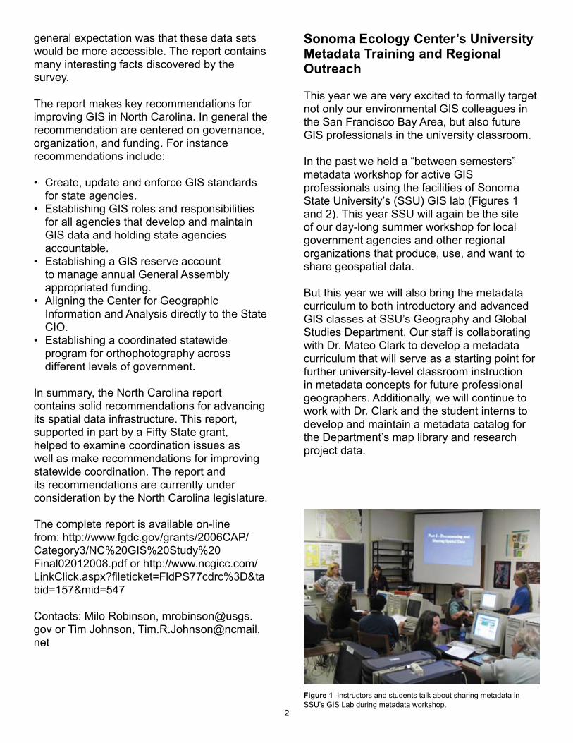
Sonoma Ecology Center’s University Metadata Training and Regional Outreach
This year we are very excited to formally target not only our environmental GIS colleagues in the San Francisco Bay Area, but also future GIS professionals in the university classroom.
In the past we held a “between semesters” metadata workshop for active GIS professionals using the facilities of Sonoma State University’s (SSU) GIS lab (Figures 1 and 2). This year SSU will again be the site of our day-long summer workshop for local government agencies and other regional organizations that produce, use, and want to share geospatial data.
But this year we will also bring the metadata curriculum to both introductory and advanced GIS classes at SSU’s Geography and Global Studies Department. Our staff is collaborating with Dr. Mateo Clark to develop a metadata curriculum that will serve as a starting point for further university-level classroom instruction in metadata concepts for future professional geographers. Additionally, we will continue to work with Dr. Clark and the student interns to develop and maintain a metadata catalog for the Department’s map library and research project data.
Figure 1 Instructors and students talk about sharing metadata in SSU’s GIS Lab during metadata workshop.

3
Figure 2 Sharon Shin introduces FGDC and NSDI at metadata workshop at SSU.
In all workshops we will introduce metadata standards, successfully create standard-compliant metadata, consider metadata as part of institutional data management, and explore approaches to metadata sharing. Additionally we will demonstrate how regional agencies and organizations can immediately share
metadata through the San Francisco Bay Area Conservation Commons and California Environmental Resources Evaluation System. These agencies will collaborate to support the aggregation, publication, and sharing of environmental data and metadata throughout the region.
Contact Sharon Shin, [email protected]
EPA and Partners Geospatial Metadata Implementation Project
The EPA and Partners Geospatial Metadata Implementation Project will provide comprehensive metadata training and instruction for EPA’s geospatial community, other (non-EPA) federal agencies, state agencies, tribes, and additional groups. Participants will be provided with hands-on geospatial metadata training and consultation in order to improve metadata quality, to
4
reduce level of effort required for developing metadata, and to increase and improve the information contributed to the National Spatial Data Infrastructure (NSDI). It is expected that this effort will considerably improve geospatial data and asset reuse across various agencies while also making a significant improvement in the quality of information contributed to the NSDI Clearinghouse and Geospatial One Stop (GOS). Training sessions will provide instruction on creating metadata through existing tools that meet FGDC standards including the FGDC Content Standard for Digital Geospatial Metadata (CSDGM) as well as the North American Profile (NAP) of the ISO 19115/19139. Training will focus on the EPA’s Metadata Editor (EME) tool to help users easily create metadata that is compliant with the FGDC CSGM. Training consists of two tracks: one introductory and a second for more experienced participants who would like to see new EME enhancements, review other ISO tools, and understand more about the relationship between FGDC CSDGM and the NAP of the ISO 19115/19139. The training includes multiple web-based sessions as well as one interactive one-day training session
that will be held at the EPA Headquarters in Washington DC.
For more information, please contact:
Jessica Zichichi, [email protected], or Caroline Roberts,[email protected]
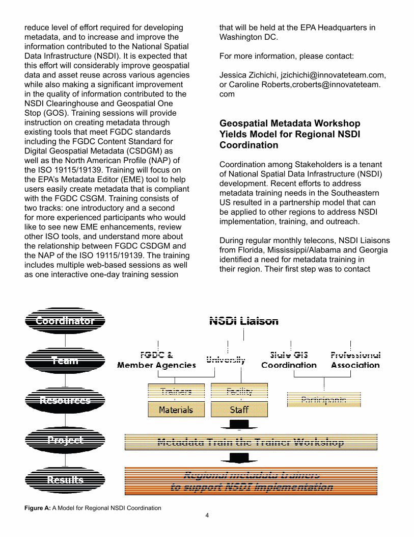
Geospatial Metadata Workshop Yields Model for Regional NSDI Coordination
Coordination among Stakeholders is a tenant of National Spatial Data Infrastructure (NSDI) development. Recent efforts to address metadata training needs in the Southeastern US resulted in a partnership model that can be applied to other regions to address NSDI implementation, training, and outreach.
During regular monthly telecons, NSDI Liaisons from Florida, Mississippi/Alabama and Georgia identified a need for metadata training in their region. Their first step was to contact
Figure A: A Model for Regional NSDI Coordination

5
the FGDC Metadata Coordinator and request assistance. The FGDC called upon Texas A&M University to provide logistical support under a grant FGDC had established with the Gulf Coast Cooperative Ecosystems Studies Unit (CESU). Texas A&M was able to provide travel support to two metadata trainers from the NOAA Coastal Data Development Center (NCDDC). The trainers had recently completed an FGDC pilot effort to establish a metadata trainer mentoring program.
With workshop interest established, funding identified and trainers enlisted, the key resources were in place to move forward with workshop planning and assign key roles. The Georgia NSDI Liaison agreed to serve the critical role of Workshop Coordinator responsible for communicating among team members and managing participant registration. The Liaison located an available training facility and enthusiastic staff support at the Carl Vinson Institute of Government’s Information Technology Outreach Services (ITOS) division at the University of Georgia (UGA). The Georgia GIS Coordinating Council (GISCC) and Georgia Chapter of the Urban and Regional Systems Association (URISA) were the primary avenues used to solicit participation. A couple of telecons, several email messages and a few weeks later, thirteen individuals from local, state and federal government successfully completed a two-day Metadata Train the Trainer Workshop with the commitment to support an NSDI Cooperative Agreements Program (CAP) grant awarded to the region and serve as a resource to their own NSDI community.
The Georgia Metadata Train the Trainer workshop effort illustrates a coordination model that builds upon available resources and skills and distributes the work load. While the partners and available resources will vary for other NSDI coordination efforts, several key components of the model can be applied (see Figure A):
• clearly establish the specific need of the community
• coordinate with your NSDI Liaison and State GIS Coordinating Body or Coordinator to identify project team members and available resources
• enlist all sectors of government, education and business to build operational solutions
• identify a Project Coordinator to manage communications and outreach
• explore FGDC CAP and other federal and state grant programs to support initiatives
• maintain focus on the need but be creative and flexible when developing solutions.
For further information, contact Lynda Wayne at [email protected].
08 NSDI CAP Awards
The final selection of the 2008 NSDI Cooperative Agreement Program (CAP) awards has been made and are listed below. The 24 awards were granted close to $1.1 millon. For more information about CAP, see http://www.fgdc.gov/grants.
CATEGORY 1: Metadata Trainer and Outreach Assistance
Metadata Training and Outreach for Tribal Environmental Science and Management on the Colorado Plateau Northern Arizona University - Merriam-Powell Center for Environmental Research
University Metadata Training and Regional OutreachSonoma Ecology Center
EPA and Partners Geospatial Metadata Implementation ProjectInnovate!, Inc.
Metadata Training for Earth Science and Cyberinfrastructure CommunitiesJoint Center for Intelligent Spatial Computing (CISC) at George Mason University
CATEGORY 2: Best Practices in Geospatial Service Oriented Architecture (SOA)

6
Role-based Access Control - Best Practices for Geospatial Service Oriented Architecture CubeWerx USA
Geospatial Service Oriented Architecture for Flood Inundation Mapping and Hazard AssessmentThe Polis Center at Indiana University Purdue University Indianapolis
Documenting Best Practices in Geospatial Service Oriented Architecture through the Development of a Wetlands Permitting SolutionImage Matters, LLC
CATEGORY 3: FIFTY STATES INITIATIVE
ColoradoGeorgiaHawai’iIdaho NebraskaPennsylvaniaSouth CarolinaU.S. Virgin Islands
CATEGORY 4: JOINT CANADIAN AND UNITED STATES SPATIAL DATA INFRASTRUCTURE PROJECT
Cross-Border Content and Services for Critical Infrastructure IdentificationThe Carbon Project
CATEGORY 5: BUILDING DATA STEWARDSHIP FOR THE NATIONAL MAP AND THE NSDI
Building Stewardship Capacity for Structures and Transportation Geodata within the Iowa Geospatial InfrastructureIowa Geographic Information Council (IGIC)
Building Stewardship of Integrated Statewide Structure and Transportation Geospatial Databases in West VirginiaWest Virginia University - GIS Technical Center
Minnesota Structures Collaborative – An Initiative to Support the National Map and NSDIMinnesota Land Management Information
Center (LMIC)
Structures Data Themes for Maryland and the National Capital RegionTowson University - Center for GIS (CGIS)
CATEGORY 6: FGDC-Endorsed Standards Implementation Assistance and Outreach (excluding Metadata Standards)
The National Vegetation Classification Standard: Implementation and Outreach for the State of OklahomaCoordinate Solutions
A Proposed Course and Modular Curriculum for FGDC Standards Adoption and ImplementationDelta State University Implementing the Standard for the U.S. National Grid North Carolina Center for Geographic Information & Analysis (CGIA)
Outreach and training on the National Vegetation Classification system to support framework layer development in MontanaUniversity of Montana
North American Profile of ISO 19115:2003, Geographic information–Metadata
A new metadata standard is on the horizon. After rounds of edits, public reviews, and adjudications of comments, the North American Profile (NAP) of ISO 19115:2003, Geographic information - Metadata has been submitted for processing for public review, which will sponsored by the American National Standards Institute (ANSI). The North American Profile will serve as a common profile of ISO 19115:2003 for the U.S. and Canada.

7
The NAP Editing Committee has recommended that the ANSI-sponsored public review be open to the geospatial community. The review is planned to take place this summer. It will be announced through the ANSI Standards Action bulletin. In addition, the review will be promoted through the FGDC website and by the FGDC Metadata Working Group. Following the ANSI-sponsored public review, a final adjudication of comments will take place. If the standard is approved by ANSI and its counterpart the Standards Council of Canada, the NAP will be released for publication by both countries. The NAP will also be submitted for FGDC endorsement.
For futher information, contact Julie Binder Maitra, [email protected].
Highlight: California University of Pennsylvania Opens Crime Mapping Center
With funding from a 2004 grant from the U.S. Department of Justice, the California University of Pennsylvania’s Earth Science Department was able to open a Crime Mapping Center that has helped local police departments identify trends while helping students interested in law enforcement build their careers.The Crime Mapping Center is equipped with Geographic Information System (GIS) technology that allows students to complete weekly and monthly crime-mapping reports for rural police departments. Students have been working during the past several years for
Back Row: California University President Angelo Armenti, Brad Clemenson, Mayor Norma Ryan of Brownsville,Front Row: Tom Mueller, Chief Stephen Cooper of Connellsville
8
the Uniontown, Brownsville, Johnstown, and Bethel Park police departments in southwest Pennsylvania. The students download call-for-service data and process them with GIS software for display on electronic maps. Students then analyze the crime data and show law enforcement officers the spatial patterns of crimes (either all crimes in the area or specific crimes, such as assault or criminal mischief). These maps help police monitor crime in their jurisdictions.
One example of using such data was the creation of a map of criminal mischief complaints that occurred near abandoned buildings. This hot spot map enabled police to track these incidents and look for trends. Students also created maps of the “mean center” (or spatial average) of robbery incidents for three separate months. This allowed the police to examine if robberies were moving in a particular direction and discuss what underlying reasons might be causing the geographical shift. The reports are also used to support applications for federal grants.
Many metropolitan police forces have units that concentrate solely on crime mapping, but police departments in this region of Pennsylvania do not have the funding for such units. The partnership with California University of Pennsylvania provides these police departments with important services they could not otherwise afford.
The center benefits students as well. It is staffed by student volunteers interested in applying what they learn in the classroom to real problems facing police. The center is run by the university’s Earth Science Planning Club, but any student from the university is welcome once he or she receives training. Working at the center has opened career doors for these students, many of whom have gone on to become professional crime analysts. As analysts, they apply the skills and experience they gained to problems of resource deployment, directed patrols, checkpoint locations, traffic accident avoidance, and community mobilization. They also help their
departments address the elements that lead to crime and the demand for police services.California University of Pennsylvania’s Earth Science Department hopes that it will be able to expand its crime-mapping services to more police departments in the future.
Contact Tom Mueller, [email protected].
Save the Date!
The NativeView, Inc. is pleased to announce Tribal College Forum VII, August 12-14, 2008, in Lawrence, KS. Hosted by Haskell Indian Nations University, this year’s Forum has the theme of “TRIBAL COLLEGE FORUM 7: Climate Crises and Water Nations are calling for Awakening” and will focus on potential economic, social, scientific and cultural impacts in Indian Country.
The Forum will provide a valuable networking environment for Native peoples, Tribal Colleges and Universities (TCU), and industry and interagency professionals who will help us make our nations strong into the 21st century.
Participants will engage with Tribal leaders, TCU Presidents, Inter Agency professionals and private industry to define and address the impacts of climate change on Indian Country, the United States, and the world. Participants will also develop relationships with colleagues from around the country, share successful experiences, and develop a

9
deeper understanding of NativeView, Inc. and its vision for strengthening tribal education and employment.
For more information, go to: www.cresis.ku.edu/tcfvii.
Contact James Rattling Leaf; NativeView, Inc. President (605)-685-4015, [email protected], Gene Napier; USGS Central Region American Indian Liaison (605) 594-6088, [email protected] or Dan Wildcat; Haskell Indian Nations University (785) 832-6677, [email protected].
Costs, registration, and Forum VII information will be released soon! Tribal College Forum VIIAugust 12-14, 2008Climate Crises and Water Nations are calling for Awakening
The 10th Global Spatial Data Infrastructure ConferenceTrinidad, 25-29 February 2008
The GSDI Association held its first conference in the Caribbean Nations – the 10th International Conference for Spatial Data Infrastructure - 25 to 29 February 2008. The University of the West Indies (UWI), St. Augustine, Port of Spain, Trinidad, hosted the conference with over 250 participants, 130 presentations and featuring 8 workshops. The theme of the conference was “Small Island Perspectives on Global Challenges: The Role of Spatial Data in Supporting a Sustainable Future.”
Prof. Clement Sankat, Pro-vice Chancellor and Principal of UWI welcomed the conference in the opening plenary and Jarmo Ratia Director of the Finnish Cadastral Survey and the GSDI’s outgoing President highlighted GSDI’s accomplishments over the last 15 months and set the tone for the Conference. The principal Keynote Address was presented by Senator Tina Gronlund-Nunez, Minister of State in the Ministry of Planning, Housing and Environment followed by a keynote from Ambassador
Albert Ramdin, Assistant Secretary General of the Organization of American States. Mr David Gray, World Bank’s Knowledge and Management Officer for Latin America and the Caribbean Region (himself a GIS professional) informed all that the World Bank now recognizes the importance of geographic information in planning and monitoring its development loan portfolios as well as the importance of Spatial Data Infrastructure for sustainable development globally.
Other plenary sessions featured:
• David Maguire, Chief Technical Officer, ESRI • Ed Parsons, Google Geospatial Technologist • Mark Doherty, Intergraph’s Director of Technology Architecture and Strategy, Mark Doherty. • Karl Steinacker, co-Chair of the UN Geographic Information Working Group • Mark Reichardt, President of the Open Geospatial Consortium • John Wilbanks, Director of Science Commons• Chris Holmes of the Open Planning Project
Conference topics included (but were not limited to): SDI progress in a number of nations including the Caribbean, the Netherlands, Norway and Brazil, advances in the standards and interoperability, trends in the open source community, evolution of the research web, development of the Open Geo Web, linking the open source communities,’ regional and
Professor Harlan Onsrud moderates the Opening Ceremonies for the GSDI-10 Conference

10
national SDI initiatives, policies and strategies in Latin America and the Caribbean, disaster management, land administration, Island and Regional (Caribbean) challenges. Sessions and a workshop were also featured on GEO and GEOSS.
All involved wish to thank the local organising committee led by co-chairs Jacob Opadeyi and Bheshem Ramlal of UWI’s Centre for GeoSpatial Studies and Dept. of Surveying and Land Information respectively – and their volunteers and student helpers.
The GSDI conducts conferences, globally about every 15 to 18 months, along with Association business meetings, including Board and Council meetings and roundtables and workshops from GSDI Committees and Working Groups.
Paraphrased from an article by GEO:connexion International editor, Roger Longhorn, also co-Chair of the GSDI Association Legal & Socioeconomic Working Group. E-mail: [email protected]
Metadata Training for Earth Science and Cyberinfrastructure Communities
George Mason University received a Metadata Training project from the FGDC 2008 CAP program on “Metadata Training for Earth Science and Cyberinfrastucture Communities”. The project will customize metadata training materials for the earth science and cyberinfrastructure communities with support from Intergraph and other companies. Through partnership with Earth Science Information Partnership and the Cyberinfrastructure Specialty Group of AAG, metadata training will be given to professionals and students within both communities in their annual and bi-annual meetings.
Contact Phil Yang, [email protected].
George Mason University, Fairfax, Virginia

11
FGDC Secretariat StaffStaff DirectorIvan DeLoatchPhone: 703-648-5752E-mail: [email protected]
Program AssistantCarol Petr GreenoughPhone: 703-648-4150E-mail: [email protected]
Clearinghouse CoordinatorDoug NebertPhone: 703-648-4151E-mail: [email protected]
FGDC Interagency Liaison (acting)Patricia PhillipsPhone: 703-648-5931E-mail: [email protected] & GSDI SecretariatAlan StevensPhone: 703-620-01585119E-mail: [email protected] or [email protected]
Framework & Cooperating States CoordinatorMilo RobinsonPhone: 703-648-5162E-mail: [email protected]
Metadata CoordinatorSharon ShinPhone: Denver, CO 303.202.4230E-mail: [email protected]
Standards CoordinatorMs. Julie Binder MaitraPhone: 703-648-4627E-mail: jmaitra [at] fgdc.gov
Training & Education / Tribal Liaison CoordinatorBonnie GallahanPhone: 703-648-6084E-mail: [email protected]
NSDI CAP CoordinatorBrigitta Urban-MathieuxPhone: 703-648-5175E-mail: [email protected]
WebmasterVaishal ShethPhone: 703-648-5930E-mail: [email protected]
Program AnalystRoxanne LambPhone: 804-261-2653E-mail: [email protected]

12
2008 Upcoming Conferences
July 11-15 NACO Kansas City, MO August 4-8 ESRI San Diego, CA August 12-14 Tribal College Forum Lawrence, KS September 7-11 NSGIC Annual Keystone, CO September 10-12 GIS in the Rockies Loveland, CO September 21-24 ICMA Richmond, VA October 7-10 URISA New Orleans, LA October 19-24 National Congress of American Indians Phoenix, AZ November 12-14 National League of Cities Orlando, FL
2009 Upcoming Conferences
February 19-24 ACSM Salt Lake City, UT March 2-5 Coastal GeoTools Myrtle Beach, SC August Crime Mapping New Orleans, LA
590 National CenterFederal Geographic Data CommitteeU.S. Geological Survey12201 Sunrise Valley DriveReston, VA 20192
Official BusinessPenalty For Private Use $300
First Class MailPostage & Fees PaidUSGSPermit No. G-788

![WILMINGTON, NORTH CAROLINA 2018 - NC Vision Zero · [1 CEU] The Insurance Institute for Highway Safety (IIHS) conducts many vehicle evaluations to improve safety for vehicle occupants](https://img.pdfslide.us/doc/110x75/5edfbc62ad6a402d666b0ddb/wilmington-north-carolina-2018-nc-vision-zero-1-ceu-the-insurance-institute.jpg)