Embed Size (px)
Citation preview

Field GeologyField Geology
““On first examining a new district, nothing can On first examining a new district, nothing can appear more hopeless than the chaos of appear more hopeless than the chaos of rocks; but by recording the stratification and rocks; but by recording the stratification and nature of the rocks and fossils at many nature of the rocks and fossils at many points, always reasoning and predicting what points, always reasoning and predicting what will be found elsewhere, light soon begins to will be found elsewhere, light soon begins to dawn on the district, and the structure of the dawn on the district, and the structure of the whole becomes more or less intelligible.”whole becomes more or less intelligible.”
- Charles Darwin

Geologic mapsGeologic maps constitute a fundamental and constitute a fundamental and objective scientific foundation on which land-objective scientific foundation on which land-use, water-use, and resource-use decisions are use, water-use, and resource-use decisions are based. A geologic map records the distribution based. A geologic map records the distribution of rock and sediment materials at and near the of rock and sediment materials at and near the land surface, and is the best science product to land surface, and is the best science product to display the information that decision makers display the information that decision makers need to identify and protect valuable resources, need to identify and protect valuable resources, avoid risks from natural hazards, and make wise avoid risks from natural hazards, and make wise use of our land. use of our land.
What is a Geologic Map?What is a Geologic Map?

The geologic mapperThe geologic mapper strives to strives to understand the composition and understand the composition and structure of geologic materials at structure of geologic materials at the Earth's surface and at depth, the Earth's surface and at depth, and to depict observations and and to depict observations and interpretations on maps using interpretations on maps using symbols and colors. symbols and colors.

Drawing Map ContactsDrawing Map Contacts
Three fundamental types of contacts: Three fundamental types of contacts: Depostional, Fault and Intrusive.Depostional, Fault and Intrusive.
Solid lines are definite contacts, dashed lines are Solid lines are definite contacts, dashed lines are approximate contacts, dotted lines are concealed approximate contacts, dotted lines are concealed contacts.contacts.
Faults are drawn in heavier lines and have Faults are drawn in heavier lines and have associated kinematic sympols.associated kinematic sympols.
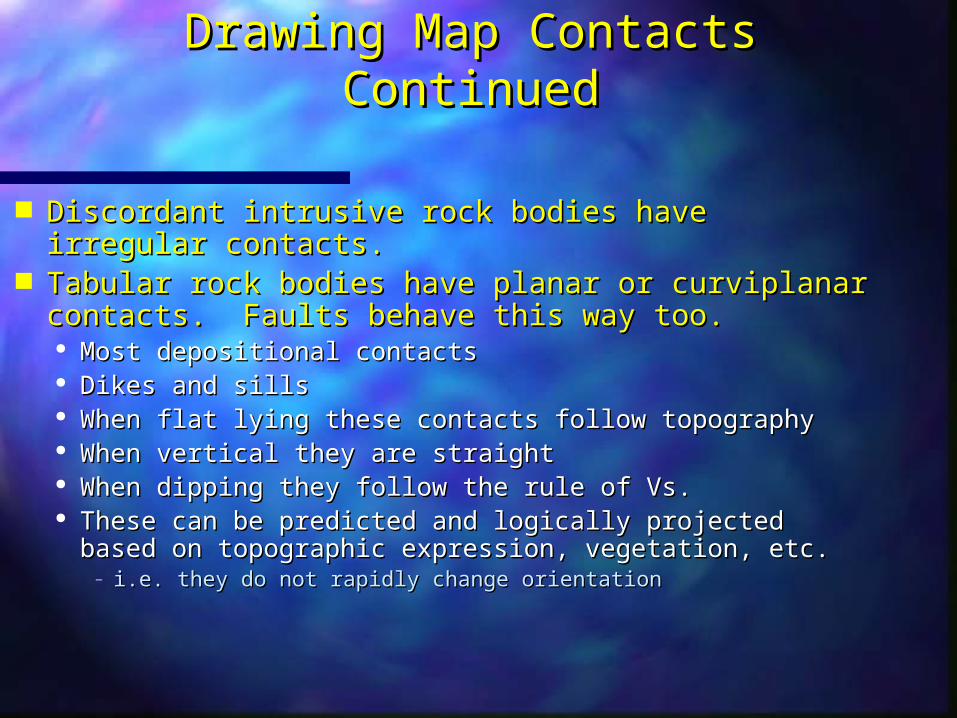
Drawing Map Contacts ContinuedDrawing Map Contacts Continued
Discordant intrusive rock bodies have irregular contacts.Discordant intrusive rock bodies have irregular contacts. Tabular rock bodies have planar or curviplanar contacts. Tabular rock bodies have planar or curviplanar contacts.
Faults behave this way too. Faults behave this way too. Most depositional contactsMost depositional contacts Dikes and sillsDikes and sills When flat lying these contacts follow topographyWhen flat lying these contacts follow topography When vertical they are straightWhen vertical they are straight When dipping they follow the rule of Vs.When dipping they follow the rule of Vs. These can be predicted and logically projected based on These can be predicted and logically projected based on
topographic expression, vegetation, etc.topographic expression, vegetation, etc.– i.e. they do not rapidly change orientationi.e. they do not rapidly change orientation
Objectives of MappingObjectives of Mapping
Accurately show surface distribution of Accurately show surface distribution of bedrock units (i.e. contacts)bedrock units (i.e. contacts)
Present sufficient structural data to Present sufficient structural data to interpret the three-dimensional interpret the three-dimensional subsurface geometry of rock unitssubsurface geometry of rock units
You can’t have too much structure data!You can’t have too much structure data!

Mapping ProceduresMapping Procedures
Keep field and office mapsKeep field and office maps Your office map is your insurance policyYour office map is your insurance policy
Do all mapping in the fieldDo all mapping in the field Draw all contacts in the fieldDraw all contacts in the field Color units in the fieldColor units in the field Plot strikes and dips in the fieldPlot strikes and dips in the field Why? – Why? –
– Allows you to see inconsistencies and plan a mapping Allows you to see inconsistencies and plan a mapping strategystrategy
– Field maps will be collected and graded without warningField maps will be collected and graded without warning

Mapping ProceduresMapping Procedures
Keep track of your location at all timesKeep track of your location at all times Know the contour interval and scale of the Know the contour interval and scale of the
mapmap Use terrain recognition, triangulation or any Use terrain recognition, triangulation or any
other method to accurately locate yourselfother method to accurately locate yourself Keep a record of your field stationsKeep a record of your field stations
Identify the location of each station in your Identify the location of each station in your notebook and on your map.notebook and on your map.

Drawing Map ContactsDrawing Map Contacts
Use different lines for different types of Use different lines for different types of contactscontacts Solid, dashed, and dotted all indicate something Solid, dashed, and dotted all indicate something
differentdifferent Tabular rock bodies have planar or Tabular rock bodies have planar or
curviplanar contactscurviplanar contacts Most depositional contactsMost depositional contacts Dikes and sillsDikes and sills These can be predicted and logically projected These can be predicted and logically projected
based on topographic expression, vegetation, etc.based on topographic expression, vegetation, etc.– i.e. they do not rapidly change orientationi.e. they do not rapidly change orientation

Drawing Map ContactsDrawing Map Contacts
Dipping beds: Obey the Rule of V’sDipping beds: Obey the Rule of V’s Contacts will commonly “V” in the direction of dipContacts will commonly “V” in the direction of dip
– One exception to this rule:One exception to this rule:– when bedding dips less steeply, and in the same direction when bedding dips less steeply, and in the same direction
as the surface slope, V points up-dipas the surface slope, V points up-dip
Contacts will parallel strike ridges and Contacts will parallel strike ridges and hogbackshogbacks Contacts commonly occur at the base of a dip or Contacts commonly occur at the base of a dip or
an anti-dip slopean anti-dip slope Contacts may be zig-zag or diamond shaped Contacts may be zig-zag or diamond shaped
along flatironsalong flatirons

Rule of V’s

Rule of V’s
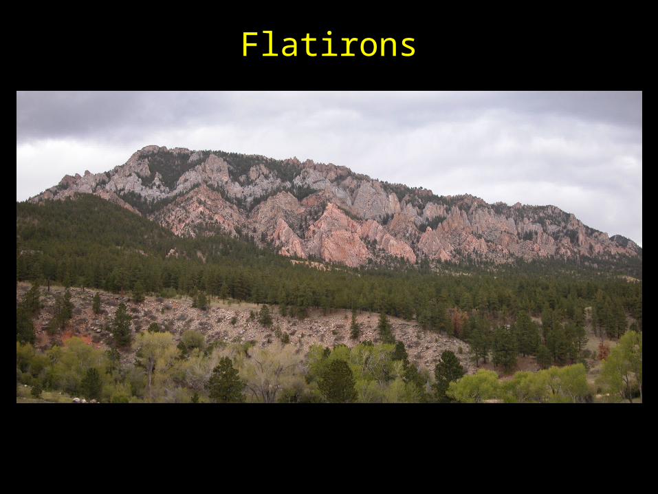
Flatirons

Special Map UnitsSpecial Map Units
Qal – Quaternary alluviumQal – Quaternary alluvium Refers to Recent stream depositsRefers to Recent stream deposits Generally flat-lying…..gently sloping down streamGenerally flat-lying…..gently sloping down stream Found where streams have low gradientsFound where streams have low gradients Generally thin for mountain streams.Generally thin for mountain streams.
Qls – Quaternary landslideQls – Quaternary landslide Refers to recent landslide depositsRefers to recent landslide deposits Often indicated by convex down-hill distortions of Often indicated by convex down-hill distortions of
elsewhere parallel topographic contourselsewhere parallel topographic contours Bedrock contacts should be dotted as Bedrock contacts should be dotted as
concealed beneath these depositsconcealed beneath these deposits

Coloring Your MapColoring Your Map
Do this in the fieldDo this in the field Color lightly – you’re going to erase a lotColor lightly – you’re going to erase a lot
Choose visually appealing colorsChoose visually appealing colors USGS has selected colors for different time USGS has selected colors for different time
periodsperiods Reserve yellows and oranges for Qal and Reserve yellows and oranges for Qal and
QlsQls

Official USGS Map ColorsOfficial USGS Map Colors
QuaternaryQuaternary orangeorange
TertiaryTertiary yellow ocheryellow ocher
CretaceousCretaceous olive-greenolive-green
JurassicJurassic blue-greenblue-green
TriassicTriassic bluish gray-greenbluish gray-green
PermianPermian blueblue
PennsylvanianPennsylvanian graygray
MississippianMississippian blue-violetblue-violet
DevonianDevonian heliotropeheliotrope
SilurianSilurian purplepurple
OrdovicianOrdovician red-violetred-violet
CambrianCambrian brick redbrick red
PrecambrianPrecambrian pink or gray-brownpink or gray-brown
Structural DataStructural Data
Be careful to select a good spot to measureBe careful to select a good spot to measure No slump blocksNo slump blocks No cross-bedding surfacesNo cross-bedding surfaces
Collect enough data to accurately represent Collect enough data to accurately represent the structural geometry of the areathe structural geometry of the area Depends on structural complexity of areaDepends on structural complexity of area Attempt uniform distribution of data when possibleAttempt uniform distribution of data when possible Gather more data along your line of cross section.Gather more data along your line of cross section.

Good Field Sketches Result in a Good Field Sketches Result in a Better MapBetter Map
Sketch out complicated map patternsSketch out complicated map patterns Helps you recognize problemsHelps you recognize problems Develop multiple working hypotheses for how units Develop multiple working hypotheses for how units
are arrangedare arranged Sketch out simplified cross sectionsSketch out simplified cross sections
Helps you recognize poor surface contact Helps you recognize poor surface contact placementplacement
Helps you identify faults and determine their Helps you identify faults and determine their geometry and sense of slipgeometry and sense of slip
Helps you when you later draw your final cross Helps you when you later draw your final cross sectionsection

Variables Affecting Map PatternsVariables Affecting Map Patterns
Formation thicknessFormation thickness Formation dipFormation dip Surface topographySurface topography
Map patterns are predictable when units are Map patterns are predictable when units are uniformly thick and homoclinally dippinguniformly thick and homoclinally dipping

Topography and Map Patterns

Testing for Mapping AccuracyTesting for Mapping Accuracy
Don’t forget thickness, depth, and three-point Don’t forget thickness, depth, and three-point problems will help!problems will help!
Calculate strike and dip from your map patternCalculate strike and dip from your map pattern It should match the measured valueIt should match the measured value
Construct the outcrop pattern in areas that are Construct the outcrop pattern in areas that are poorly constrainedpoorly constrained Requires uniform dips and thicknessesRequires uniform dips and thicknesses
Calculate formation thickness from your map Calculate formation thickness from your map patternpattern
It should be in the range we established, unless noted otherwise.It should be in the range we established, unless noted otherwise.
What you need for tomorrowWhat you need for tomorrow
A positive attitudeA positive attitude Colored pencilsColored pencils Map (something to cover it in a rainstorm)Map (something to cover it in a rainstorm) ClipboardClipboard Protractor/RulerProtractor/Ruler CompassCompass Radio – one per groupRadio – one per group Rain gearRain gear