Embed Size (px)
Citation preview
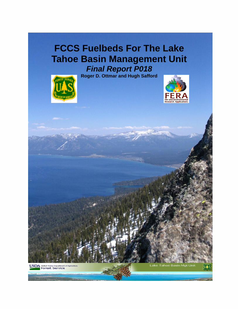
FCCS Fuelbeds For The Lake Tahoe Basin Management Unit
Final Report P018
Roger D. Ottmar and Hugh Safford
FCCS Fuelbeds for the Lake Tahoe Basin
Final Report P018
Roger D. Ottmar1 and Hugh Safford
2
1Principal Investigator
U.S. Forest Service, Pacific Northwest Research Station
400 North 34th
Street, Suite 201, Seattle, WA 98103
Phone: (206) 732-7826
Fax (206) 732-7801
2Co-Principal Investigator
U.S. Forest Service, Pacific Southwest Region
1323 Club Drive, Vallejo, CA 94592
Phone: (707) 562-8934
Fax (707) 562-9050
April 9, 2011
This research was sponsored in part by the Lake Tahoe Basin Management Unit
Abstract
We used the Fuel Characteristic Classification System (FCCS) to develop a set of past, current,
and future fuelbeds for the Lake Tahoe Basin Management Unit (LTBMU). Through group
consensus of LBTMU managers, six major fuelbed types were identified that occur in the basin
including: 1) jeffrey pine-white fir, 2) red fir, 3) wet lodgepole pine, 4) whitebark pine-
lodgepole, 5) mountain hemlock, and 6) mixed confer. Fuelbed pathways were completed for
each of the major fuelbed type and 88 fuelbeds were identified for development. Twenty
additional fuelbeds were identified and developed to represent unique vegetation types that did
not fall within the six fuelbed types. The fuelbeds were constructed using the FCCS, scientific
and grey literature, and measured fuels data. A Fuelbed Pathway Handbook was compiled that
includes the six fuelbed types, pathway schematics, fuelbed names and descriptions, fire
behavior estimates and general photographs assigned to the fuelbeds. Thirty one of the major
fuelbeds and 20 of the unique fuelbeds were cross-walked to vegetation attributes from the
CALVEG data set and mapped for the LTBMU. The Fuelbed Pathway Handbook, FCCS
fuelbeds, and fuelbed map were presented at the Forest Management Decision Support Tools
Symposium held at Incline Village, NV and at a workshop conducted the following day. Defining and mapping important fuelbeds for the LTBMU will enable managers to better plan restoration
and wildlife habitat projects and account for potential fire hazard, smoke from wildland fire, and carbon.
FCCS Fuelbeds For Lake Tahoe Basin Management Unit
3
Background and Purpose
As fire models become more sophisticated and widely used, there is an increasing need to
accurately quantify and classify the structural and geographical diversity of wildland fuels.
Defining these fuelbeds will provide inputs for current and future fire and fuel models enabling
managers to better plan restoration projects, quantify potential fire behavior, fire effects, and
smoke emissions, account for carbon, and protect and enhance wildlife habitat throughout the
Lake Tahoe Basin Management Unit (LTBMU). Although the LTBMU has fire behavior fuel
model maps, those do not provide a representation of realistic fuels required by today’s planning
processes. Consequently, the LTBMU collaborated with the Fire and Environmental Research
and Applications (FERA) team of the Pacific Wildland Fire Research Laboratory to create a
comprehensive set of Fuel Characteristic Classification System (FCCS) fuelbeds (Ottmar et al.
2007; Riccardi et al. 2007) representing the past, current and potential future conditions of major
forest and rangeland types, management activities, and natural disturbances occurring within the
LTBMU.
What is the FCCS? It is a software system to build fuelbeds with realistic fuels data and predict
their relative fire hazard (Ottmar et al. 2007, Riccardi et al. 2007). Users can modify FCCS
fuelbeds to create a set of customized fuelbeds representing any scale of interest. FCCS
calculates the relative fire hazard of each fuelbed, including surface fire behavior, crown fire,
and available fuel potentials, scaled on an index from 0 to 9 (Sandberg et al. 2007b). These
FCCS fire potentials facilitate communication of fire hazard among users by providing an index
of the intrinsic capacity of each fuelbed for surface fire behavior, crown fire and fuels available
for consumption. The FCCS fire potentials also offer an easy way to evaluate fuels treatment
effectiveness. In addition to the FCCS fire potentials, the FCCS also predicts surface fire
behavior, including reaction intensity (btu ft-2
sec-1
), flame length (ft), and rate of spread (ft min-
1) based on benchmark and user-specified environmental conditions. Using a modified
Rothermel spread equation, FCCS evaluates each fuelbed stratum separately for reaction
intensity and heat sink terms, accounting for changes that occur between fuelbed strata due to
natural succession or a natural or human change agent (Sandberg et al. 2007a). By comparing
predicted flame length and rate of spread between the fuelbed and fire behavior fuel models, the
FCCS provides a crosswalk to one of the original 13 Fire Behavior Prediction System fuel
models and one of the 40 standard fuel models (Scott and Burgan 2005). Finally, the FCCS
reports carbon storage by fuelbed category and subcategory.
Study Location and Description
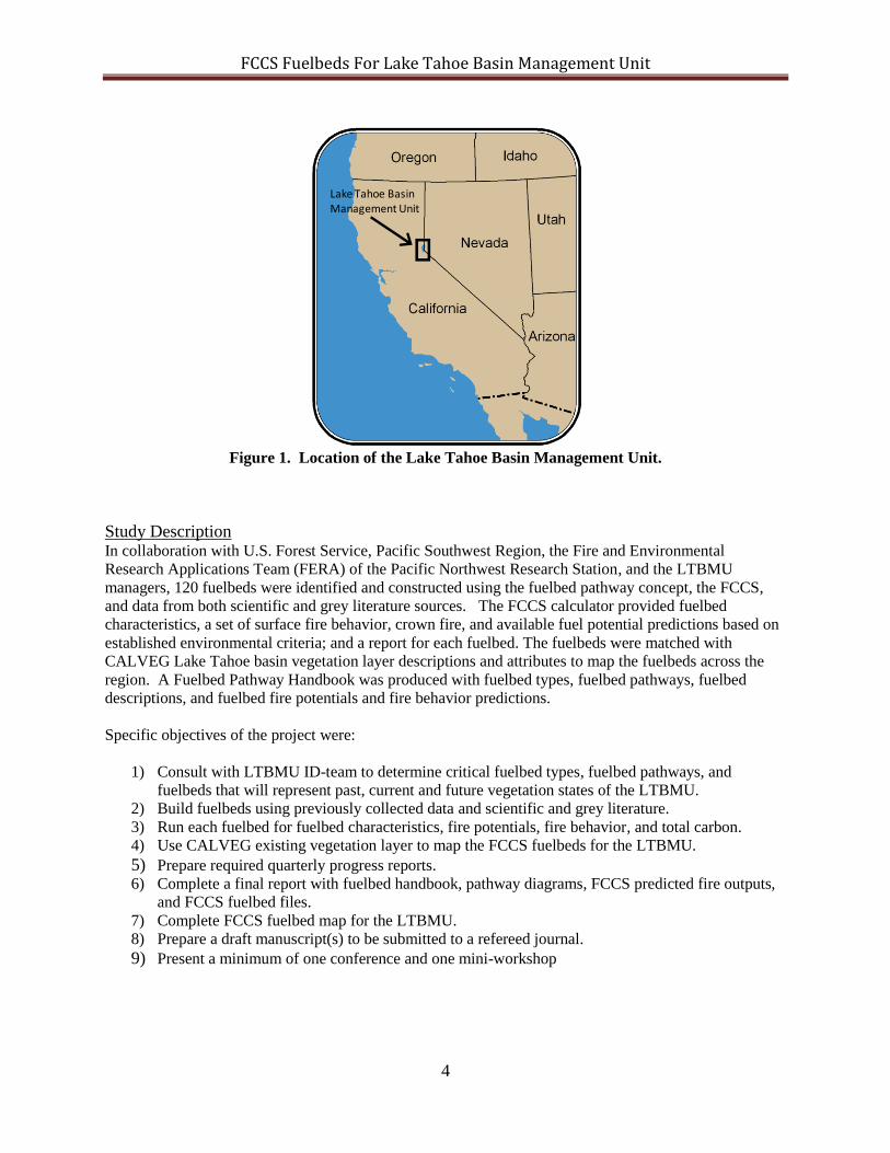
Study Area
The study area is the 150,000 acre Lake Tahoe Basin Management Unit located on the California and
Nevada border. Initially, the study area was to be confined to the Angora fire area (Fig. 1). However,
following discussions with the LTBMU managers, it was decided the study will include the entire Lake
Tahoe Basin Management Unit.
FCCS Fuelbeds For Lake Tahoe Basin Management Unit
4
Figure 1. Location of the Lake Tahoe Basin Management Unit.
Study Description
In collaboration with U.S. Forest Service, Pacific Southwest Region, the Fire and Environmental
Research Applications Team (FERA) of the Pacific Northwest Research Station, and the LTBMU
managers, 120 fuelbeds were identified and constructed using the fuelbed pathway concept, the FCCS,
and data from both scientific and grey literature sources. The FCCS calculator provided fuelbed
characteristics, a set of surface fire behavior, crown fire, and available fuel potential predictions based on
established environmental criteria; and a report for each fuelbed. The fuelbeds were matched with
CALVEG Lake Tahoe basin vegetation layer descriptions and attributes to map the fuelbeds across the
region. A Fuelbed Pathway Handbook was produced with fuelbed types, fuelbed pathways, fuelbed
descriptions, and fuelbed fire potentials and fire behavior predictions.
Specific objectives of the project were:
1) Consult with LTBMU ID-team to determine critical fuelbed types, fuelbed pathways, and
fuelbeds that will represent past, current and future vegetation states of the LTBMU.
2) Build fuelbeds using previously collected data and scientific and grey literature.
3) Run each fuelbed for fuelbed characteristics, fire potentials, fire behavior, and total carbon.
4) Use CALVEG existing vegetation layer to map the FCCS fuelbeds for the LTBMU.
5) Prepare required quarterly progress reports. 6) Complete a final report with fuelbed handbook, pathway diagrams, FCCS predicted fire outputs,
and FCCS fuelbed files.
7) Complete FCCS fuelbed map for the LTBMU.
8) Prepare a draft manuscript(s) to be submitted to a refereed journal.
9) Present a minimum of one conference and one mini-workshop
Lake Tahoe Basin Management Unit
FCCS Fuelbeds For Lake Tahoe Basin Management Unit
5
Methods
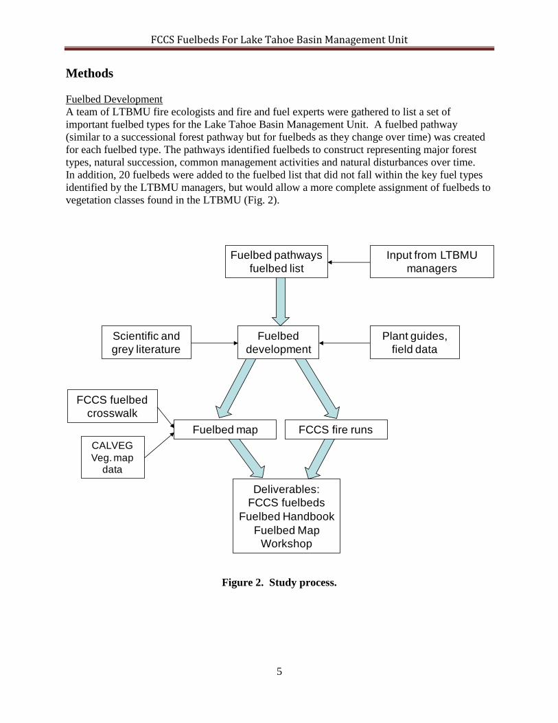
Fuelbed Development
A team of LTBMU fire ecologists and fire and fuel experts were gathered to list a set of
important fuelbed types for the Lake Tahoe Basin Management Unit. A fuelbed pathway
(similar to a successional forest pathway but for fuelbeds as they change over time) was created
for each fuelbed type. The pathways identified fuelbeds to construct representing major forest
types, natural succession, common management activities and natural disturbances over time.
In addition, 20 fuelbeds were added to the fuelbed list that did not fall within the key fuel types
identified by the LTBMU managers, but would allow a more complete assignment of fuelbeds to
vegetation classes found in the LTBMU (Fig. 2).
Figure 2. Study process.
Fuelbed
development
Fuelbed pathways
fuelbed list
FCCS fuelbed
crosswalk
Fuelbed map
CALVEG
Veg. map data
Deliverables:
FCCS fuelbeds
Fuelbed Handbook
Fuelbed Map
Workshop
Scientific and
grey literature
Plant guides,
field data
FCCS fire runs
Input from LTBMU
managers
FCCS Fuelbeds For Lake Tahoe Basin Management Unit
6
Fuelbeds provided in the FCCS system or similar fuelbeds from other projects (i.e.
Okanogan/Wenatchee Nation forest project, Central Oregon Project) were used as starting points
for creating the LTBMU fuelbeds. Local data, plant association guides, photo series, inventory
data bases, and expert opinion were used to modify the fuelbed descriptions and adjust fuelbed
inputs including loading, depths, percent cover, and species to represent the fuelbeds identified in
the pathways and that fell outside the six important fuelbed types.
Fuelbed Characteristics
Fuelbed characteristics including fuel loading and carbon by fuelbed strata, categories, and
subcategories were calculated for each fuelbed using the FCCS.
Fire Behavior
FCCS version 2.1 was used to calculate 1) FCCS surface fire behavior, crown fire, and available
fuels potentials; and 2) reaction intensity, rate of spread, and flame length (Sandberg et al. 2007a;
Sandberg et al. 2007b) for each fuelbed at three moisture scenarios (low, medium, and high),
mid-flame windspeeds (0, 3, 7 mph) and slopes (0, 30, 70%). Suggested crosswalks to the
original Fire Behavior Prediction System (Rothermel 1972, Albini 1976) and standard fuel
models (Scott and Burgan, 2005) were also determined at three moisture scenarios (low,
medium, high), mid-flame windspeeds (0, 3, 7 mph) and slopes (0, 30, 70%).
Fuelbed handbook
General information on the fuelbed types, fuelbed pathways, fuelbeds, fire potentials, surface fire
behavior prediction, and fire behavior fuel model crosswalk were compiled into a Lake Tahoe
Basin Fuelbed Pathway Handbook. The fuelbed types and pathways information is summarized
in schematics and tables that include the fuelbed names, description, the age class, and any
management actions or natural change agents associated with each fuelbed. All fuelbed outputs
are presented in summary tables. The 108 fuelbeds are available from the FERA website for
input into the FCCS allowing additional outputs to be observed including fuel loading and
available carbon by fuelbed category (http://www.fs.fed.us/pnw/fera/fccs/downloads.shtml#sf).
Representative photos for many fuelbed were collected and provided in the handbook. Photos
were collected and added to the handbook to illustrate general structural features of the fuelbeds
only and were not intended to represent actual species composition or fuel loadings.
Fuelbed map
To map FCCS fuelbeds we used CALVEG data for the Lake Tahoe Basin Management Unit
(USDA 2008). The vegetation type (Regional Dominance type) and overstory tree size class
were used to create unique classes. These unique vegetation classes matched closely with the
fuelbed type, age, and characteristics of the pathways and fuelbeds and a simple crosswalk was
created. Once a fuelbed map produced, it was discovered that there were more vegetation
classes than fuelbed types developed for the basin and the map coverage was less than 90
percent. To improve map coverage, 20 additional fuelbeds outside the fuelbed types were
constructed and added to the map to achieve a +99.5 % fuelbed coverage of the Lake Tahoe
Basin Management Unit.
FCCS Fuelbeds For Lake Tahoe Basin Management Unit
7
Results
The majority of the results are presented in the Fuelbed Pathway Handbook and the Fuelbed Map
in Appendix A. These were the two major deliverables for the project.
Fuelbeds
There were 6 fuelbed types identified by the LTBMU managers and 6 fuelbed pathways
developed to account for natural succession, fuels management activities, and natural and human
change agents. Harvest types, fuel treatments, and natural change agents were considered when
constructing the pathways and included: clearcut, pre-commercial thin, select-cut, salvage, pile
and burn, pile and no burn, prescribed fire, mastication; crown wildfire, ground wildfire, insect
and disease, avalanche, and none.
The fuelbed types and number of fuelbeds constructed for each type include:
Jeffrey and white fir (28 fuelbeds)
Red fir (22 fuelbeds)
Wet lodgepole pine (8 fuelbeds)
Whitebark pine, lodgepole pine (8 fuelbeds)
Moutain hemlock (6 fuelbeds)
Mixed conifer (28 fuelbeds)
Twenty additional fuelbeds were identified and constructed to account for vegetation not covered
by the 6 fuelbed types but that represented a significant portion of the LTBMU landscape. These
included: 1) huckleberry oak shrub, 2) green leaf manzanita, 3) short hair reed grass-thread leaf
sedge, 4) sapling aspen, 5) pole aspen, 6) medium aspen, 7) black cottonwood, 8) chamise
chaparral, 9) sagebrush 10) western juniper/sagebrush/bitterbrush, 11) willow-mountain alder,
l2) low sagebrush, 13) mountain mahogany, 14) avalanche disturbed aspen, 15) large ponderosa
pine, 16) sapling Douglas-fir/ponderosa pine, 17) sapling ponderosa pine, 18) bitterbrush and
rabbit brush, 19) western juniper savanna, and 20) old sagebrush.
Fuelbed characteristics
Over 300 input variables and calculated characteristics are available for each LTBMU fuelbed.
In this report, we provide only loading (t a-1
) for each major fuel category and total aboveground
carbon (Appendix 1). Additional characteristics can be calculated or reported by running the
LTBMU fuelbeds in the FCCS. The total loading ranged from 1.4 t a-1
for the low sagebrush
additional fuelbed LF308 with only shrub biomass to mixed conifer LT064 fuelbed 80-120 years
old with a substantial tree bole and woody fuel mass. The shrub, grass, woody fuel, and litter
fuelbed categories drive the surface fire behavior reaction intensity, spread rate and flamelength
for surface fire behavior. Total biomass for these 4 categories ranged from 1.1 t a-1
for the
additional bitterbrush fuelbed CO208 with no litter and small woody fuels to 17.7 t a-1
for the
mixed conifer fuelbed LT088 120+ years.
FCCS Fuelbeds For Lake Tahoe Basin Management Unit
8
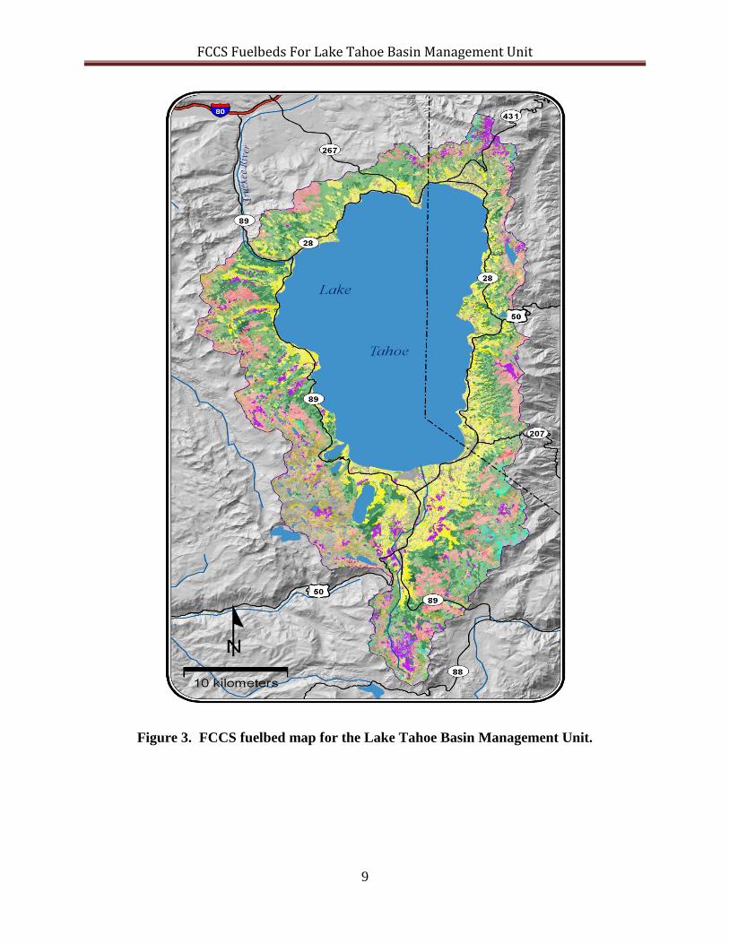
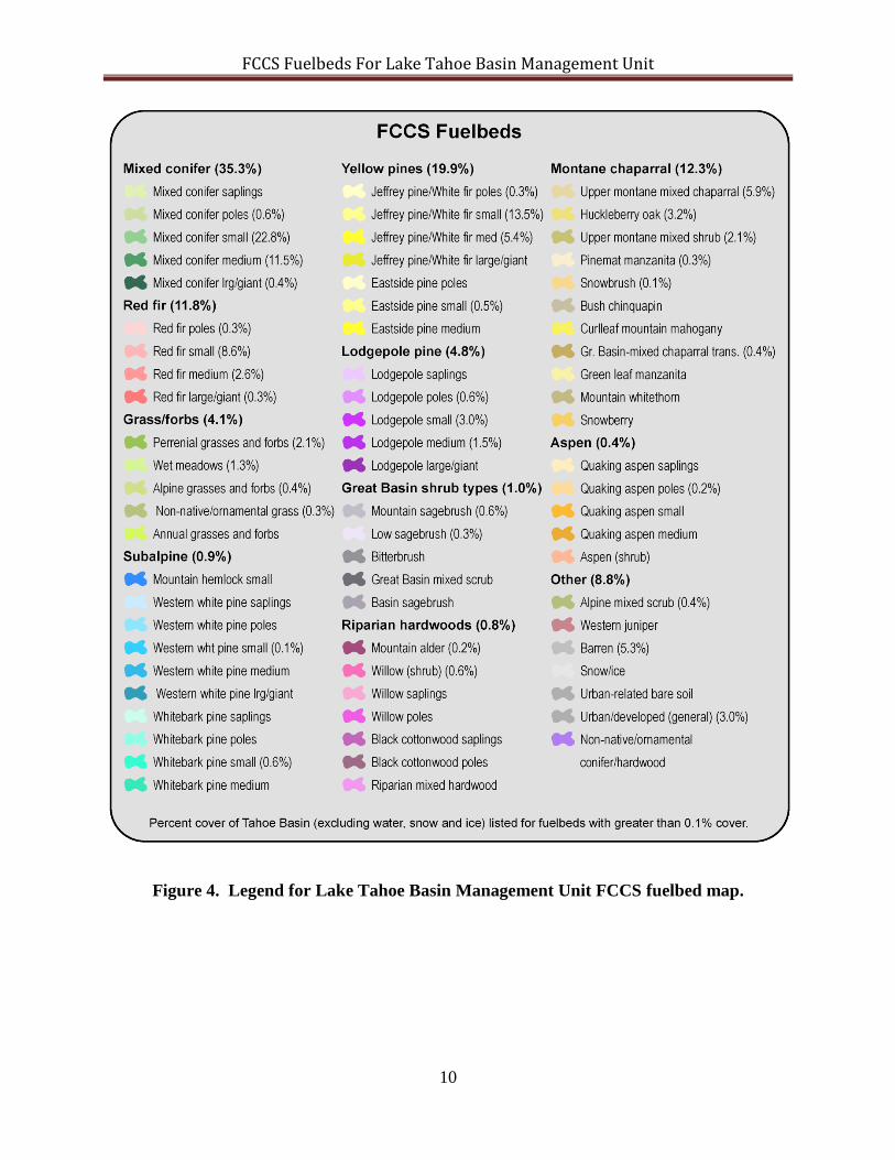
Fuelbed map
There were more fuelbeds developed for the Lake Tahoe Basin area than vegetation classes from
the CALVEG data set. The data set did not distinguish between human or natural change agents
so fuelbeds that naturally progressed from one age class to the next without a change agent were
the only fuelbeds mapped. This allowed only 31 of the 100 fuelbeds developed for the six
fuelbed types to be mapped. To achieve a more complete coverage of the LTBMU, 20
additional fuelbeds were constructed for vegetation classes without a matched fuelbed and added
to the fuelbed list. Appendix 2 displays the CALVEG vegetation classes and FCCS fuelbed
crosswalk. The fuelbed map and legend are displayed in Figs. 3 and 4. A majority of the
mapped coverage was in the mixed conifer and yellow pine categories (55.2%), followed by
montane chaparral and red fir (24.1 %). Grass and forbs, subalpine, lodgepole pine, great basin
shrub types, riparian hardwoods, aspen and other accounted for the remaining area (20.8%).
Modeled fire behavior
FCCS surface fire behavior, crown fire, and available fuels potentials; reaction intensity, rate of
spread, and flame length; suggested crosswalks to the original Fire Behavior Prediction System
and standard fuel models are presented in summary tables of the Lake Tahoe Fuelbed Pathway
Handbook. FCCS fire potentials ranged from 1 0 5 for the red fir fuelbed LT 0 3 3, 120+ years
old that has been select cut, piled and burned at moisture scenario high, 0% slope, and 0 mph
wind speed to 9 6 9 for the red fir fuelbed LT032, 120+ years old with no management at
moisture scenario low, 70% slope and 7 mph wind. The reaction intensity ranged from 560 btu
ft-2
sec-1
for the wet lodgepole pine fuelbed LT038, 0-10 years old with no management action at
high fuel moisture content, 0% slope and 0 mph wind speed to16,119 btus ft-2
sec-1
for the mixed
conifer fuelbed LT062, 25-50 years old with no management at a low moisture, 70% slope and 7
mph wind. Flamelength ranged from 0.2 feet for the wet lodgepole pine fuelbed LT042, 40-80
year old with no treatment, high moisture content, 0 % slope and 0 mph wind speed to 25.3 feet
for mixed conifer fuelbed LT062 25-50 years old with no treatment, at low fuel moisture content,
70% slope, and 7 mph wind speed. The rate of spread ranged from 0 ft/min-1
for the wet
lodgepole pine fuelbed LT042, 40-80 years old with no treatment, high moisture content, 0 %
slope and 0 mph wind speed to 81.4 ft/min-1
for fuelbed LT062 with no treatment at 25-50 years
old, at low fuel moisture content, 70% slope, and 7 mph wind speed. In general, the FCCS fire
potentials and surface fire behavior increased over time if there were no treatment activities in
place or if there was a change agent such as logging without fuels treatment.
FCCS Fuelbeds For Lake Tahoe Basin Management Unit
9
Figure 3. FCCS fuelbed map for the Lake Tahoe Basin Management Unit.
FCCS Fuelbeds For Lake Tahoe Basin Management Unit
10
Figure 4. Legend for Lake Tahoe Basin Management Unit FCCS fuelbed map.
FCCS Fuelbeds For Lake Tahoe Basin Management Unit
11
Discussion
Each FCCS fuelbed developed for the LTBMU represents a relatively uniform unit on the
landscape that is a unique combustion environment. These LTBMU fuelbeds provide
realistic physical fuel properties for a range of applications in fire, fuel, smoke, wildlife
habitat, and carbon assessments. The fuelbeds can be input into Consume or other software
tools to calculate fuel consumption, emissions, and potential fire effects. In addition, users
can assess the effects of human and natural disturbances on a range of fuelbed characteristics.
These can lead to a rigorous framework for planning, decision making, and policy analysis
for the LTBMU. Since the fuelbed list was developed from important fuelbed types and
pathways the fuelbeds will be especially beneficial for fuel treatment planning and evaluating
the effectiveness of the fuel treatments through space and times.
The fuelbeds for the LTBMU were developed from scientific and grey literature, photo series,
and large data bases. Although they have not been verified in the field, we believe they are
relatively accurate for most management planning. Each fuelbed can be customized with
collected data to improve the representation of a particular fuelbed. Similarly, the fire behavior
predictions are within the range of Rothermel’s equations and have been verified by anecdotal
evidence. However, they have not been validated with a scientifically collected data set. The
FCCS fuelbeds and calculated fire potentials and surface fire behavior values will be validated in
the upcoming years.
The FCCS fire potentials calculated for each LTBMU fuelbed represent the capacity of a specific
fuelbed to support a surface fire and crown fire, and to consume and smolder fuels at benchmark
environmental conditions. The fire potentials can be used to evaluate and map fire hazard,
compare and communicate the degree of fire hazard, and measure the change in fire hazard
caused by fuel management, natural events, or the passage of time in the LTBMU.
Each LTBMU fuelbed contains over 300 input variables and fire and carbon prediction outputs.
Although the fuelbed map completed for this study only delineates fuelbeds, various input
variable layers or output value layers for each fuelbed could be added to the map. For example,
it would be relatively easy to display the fire behavior and crown fire potential, reaction
intensity, flamelength, and rate of spread presented in the Fuelbed Pathway Handbook across the
LTBMU.
There are several enhancements that would improve the usefulness of this project. First, a more
thorough examination of fuel measurements that are available would allow improved fuelbed
construction. Second, Forest Vegetation Simulator runs could be used to improve stand data for
fuelbeds as they move through time. Third, specific LTBMU fuelbed inputs and outputs such as
fuel loading, carbon, snag density, etc. could be mapped for the LTBMU. Finally, each LTBMU
fuelbeds could be run through Consume and estimates of fuel consumption and emissions for
low, medium, and high moisture contents could be calculated and those values mapped.
FCCS Fuelbeds For Lake Tahoe Basin Management Unit
12
Conclusion
This project has provided a robust set of fuelbeds that represent the past, current and potential
future conditions of major forest and rangeland types, management activities, and natural
disturbances occurring within the LTBMU. These fuelbeds can be used to evaluate the
landscape for fire potential, smoke production, fuel loading, carbon storage, and wildlife habitat
across time and space of the LTBMU. This project is just the beginning, providing a solid
baseline of fuelbeds to assist in land management planning. As management actions change or
the landscape changes due to succession or natural and human change agents, additional fuelbeds
may need to be developed or the original fuelbeds modified. This will be a relatively easy
process with the fuelbed pathways and initial fuelbeds in place.
Acknowledgement
I wish to thank Dr. Clint Wright for assisting with the workshop and presenting at the Tools
conference, Travis Freed and Rob Norheim for gathering the CALVEG data layers and
developing the LTBMU fuelbed map, Tom Leuschen for assisting with the management meeting
and pathway development, and a special thanks to Anne Andreu for building the fuelbeds and
preparing the fuelbed pathway handbook.
Literature Cited
Albini, F.A. 1976. Estimating wildfire behavior and effects. USDA For. Serv. Gen. Tech.
Rep. INT-30.
Anderson, H.E. 1982. Aids to determining fuel models for estimating fire behavior. General Technical
Report, GTR-INT-122. USDA Forest Service, Intermountain Forest and Range Experiment Station.
Ogden, Utah.
Andrews, P.L.; Bevins, C.D.; Seli, R.C. 2005. BehavePlus fire modeling system, version 3.0: User's
Guide. Gen. Tech. Rep. RMRS-GTR-106 Revised. Ogden, UT: U.S. Department of Agriculture, Forest
Service, Rocky Mountain Research Station.132 p.
Ottmar, R.D., Sandberg, D.V.; Riccardi, C.L.; Prichard, S. J. 2007. An overview of the fuel characteristic
classification System (FCCS) - quantifying, classifying, and creating fuelbeds for resource planning.
Can. J. For. Res. 37:2383-2393.
Riccardi, C. L., Ottmar, R. D., Sandberg, D.V., Andreu, A., Elman, E., Kopper, K., Long, J. 2007. The
fuelbed: a key element of the fuel characteristic classification system. Can. J. For. Res. 37: 2413-2420.
Rothermel, R.C. 1972. A mathematical model for predicting fire spread in wildland fuels.
USDA For. Serv. Res. Pap. INT-115. F
Scott, J. H., Burgan, R. E. 2005. Standard fire behavior fuel models: a comprehensive set for use with
Rothermel's surface fire spread model. Gen. Tech. Rep. RMRS-GTR-153. Fort Collins, CO: U.S.
Department of Agriculture, Forest Service, Rocky Mountain Research Station. 72 p.
Sandberg, D.V., Riccardi, C.L, and Schaaf, M.D. a. Fire potential for wildland fuelbeds using
the Fuel Characteristic Classification System. Can. J. For. Res. 37:2456-2463.

FCCS Fuelbeds For Lake Tahoe Basin Management Unit
13
Sandberg, D.V., Riccardi, C.L., and Schaaf, M.D. b. Reformulation of Rothermel's wildland
fire behavior model for complex fuelbeds. Can. J. For. Res. 37: 2438-2455.
USDA (2008). CALVEG Lake Tahoe Basin Management Unit: USDA Forest Service, Pacific
Southwest Region, Remote Sensing Lab. http://www.fs.fed.us/r5/rsl/clearinghouse/aa-ref-
tmu.shtml
FCCS Fuelbeds For Lake Tahoe Basin Management Unit
14
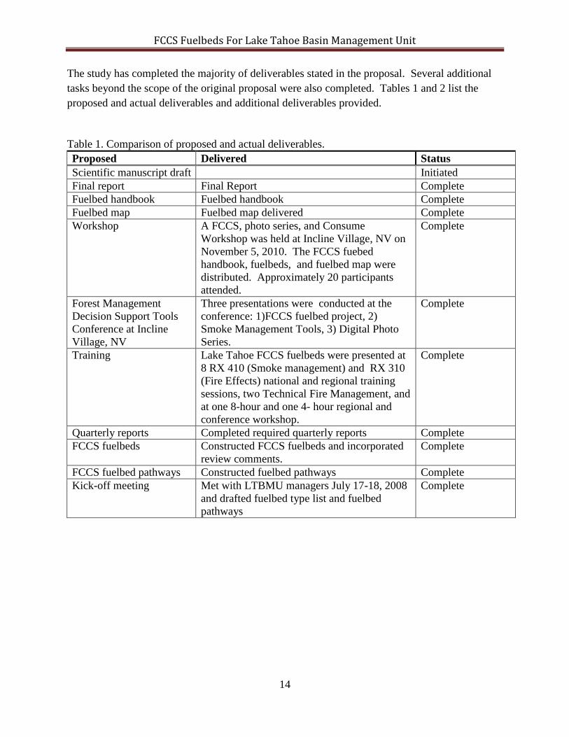
The study has completed the majority of deliverables stated in the proposal. Several additional
tasks beyond the scope of the original proposal were also completed. Tables 1 and 2 list the
proposed and actual deliverables and additional deliverables provided.
Table 1. Comparison of proposed and actual deliverables. Proposed Delivered Status
Scientific manuscript draft Initiated
Final report Final Report Complete
Fuelbed handbook Fuelbed handbook Complete
Fuelbed map Fuelbed map delivered Complete
Workshop A FCCS, photo series, and Consume
Workshop was held at Incline Village, NV on
November 5, 2010. The FCCS fuebed
handbook, fuelbeds, and fuelbed map were
distributed. Approximately 20 participants
attended.
Complete
Forest Management
Decision Support Tools
Conference at Incline
Village, NV
Three presentations were conducted at the
conference: 1)FCCS fuelbed project, 2)
Smoke Management Tools, 3) Digital Photo
Series.
Complete
Training Lake Tahoe FCCS fuelbeds were presented at
8 RX 410 (Smoke management) and RX 310
(Fire Effects) national and regional training
sessions, two Technical Fire Management, and
at one 8-hour and one 4- hour regional and
conference workshop.
Complete
Quarterly reports Completed required quarterly reports Complete
FCCS fuelbeds Constructed FCCS fuelbeds and incorporated
review comments.
Complete
FCCS fuelbed pathways Constructed fuelbed pathways Complete
Kick-off meeting Met with LTBMU managers July 17-18, 2008
and drafted fuelbed type list and fuelbed
pathways
Complete
FCCS Fuelbeds For Lake Tahoe Basin Management Unit
15
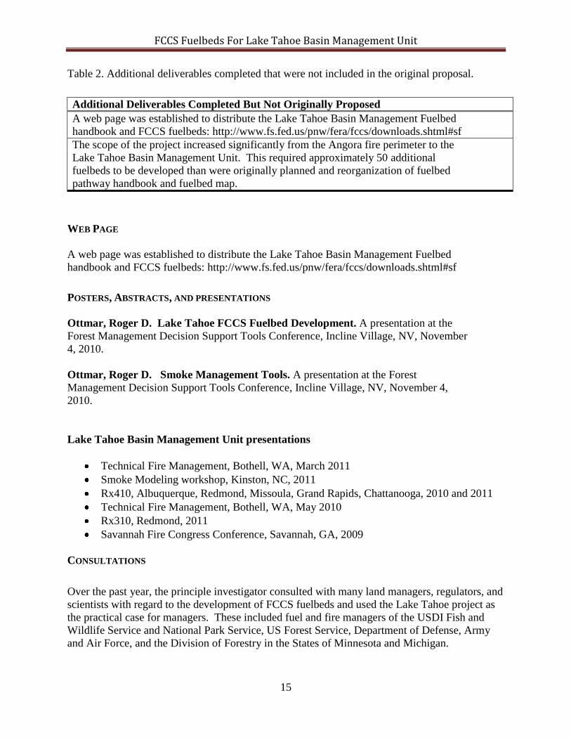
Table 2. Additional deliverables completed that were not included in the original proposal.
Additional Deliverables Completed But Not Originally Proposed
A web page was established to distribute the Lake Tahoe Basin Management Fuelbed
handbook and FCCS fuelbeds: http://www.fs.fed.us/pnw/fera/fccs/downloads.shtml#sf
The scope of the project increased significantly from the Angora fire perimeter to the
Lake Tahoe Basin Management Unit. This required approximately 50 additional
fuelbeds to be developed than were originally planned and reorganization of fuelbed
pathway handbook and fuelbed map.
WEB PAGE
A web page was established to distribute the Lake Tahoe Basin Management Fuelbed
handbook and FCCS fuelbeds: http://www.fs.fed.us/pnw/fera/fccs/downloads.shtml#sf
POSTERS, ABSTRACTS, AND PRESENTATIONS
Ottmar, Roger D. Lake Tahoe FCCS Fuelbed Development. A presentation at the
Forest Management Decision Support Tools Conference, Incline Village, NV, November
4, 2010.
Ottmar, Roger D. Smoke Management Tools. A presentation at the Forest
Management Decision Support Tools Conference, Incline Village, NV, November 4,
2010.
Lake Tahoe Basin Management Unit presentations
Technical Fire Management, Bothell, WA, March 2011
Smoke Modeling workshop, Kinston, NC, 2011
Rx410, Albuquerque, Redmond, Missoula, Grand Rapids, Chattanooga, 2010 and 2011
Technical Fire Management, Bothell, WA, May 2010
Rx310, Redmond, 2011
Savannah Fire Congress Conference, Savannah, GA, 2009
CONSULTATIONS
Over the past year, the principle investigator consulted with many land managers, regulators, and
scientists with regard to the development of FCCS fuelbeds and used the Lake Tahoe project as
the practical case for managers. These included fuel and fire managers of the USDI Fish and
Wildlife Service and National Park Service, US Forest Service, Department of Defense, Army
and Air Force, and the Division of Forestry in the States of Minnesota and Michigan.

FCCS Fuelbeds For Lake Tahoe Basin Management Unit
16
LESSON PLANS AND TRAINING
The FCCS fuelbed development project for the LTBMU has been used as a case example in
several local and regional training classes including Rx410 (smoke management), Rx310 (fire
effects), and Technical Fire Management. In addition, the protocols and process will be
demonstrated and applied from the LTBMU project to assist in the ongoing project to develop
and map FCCS for northeastern Oregon

FCCS Fuelbeds For Lake Tahoe Basin Management Unit
17
Appendix 1
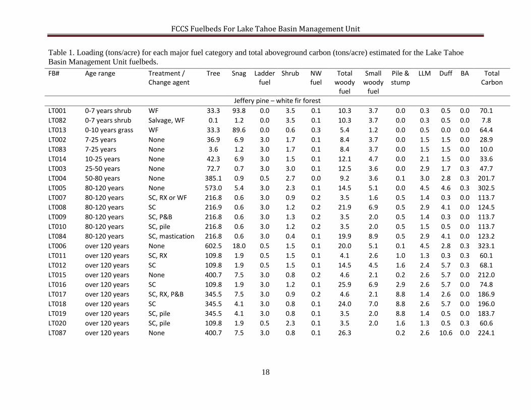
FCCS Fuelbeds For Lake Tahoe Basin Management Unit
18
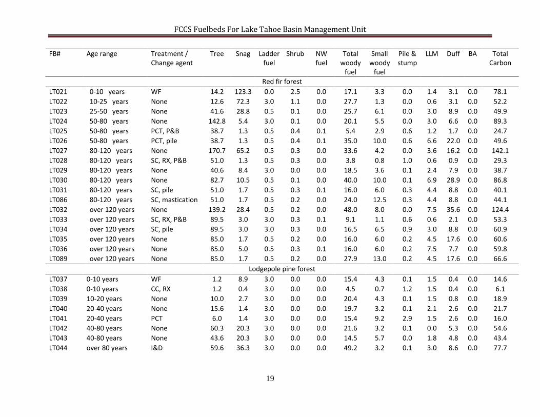
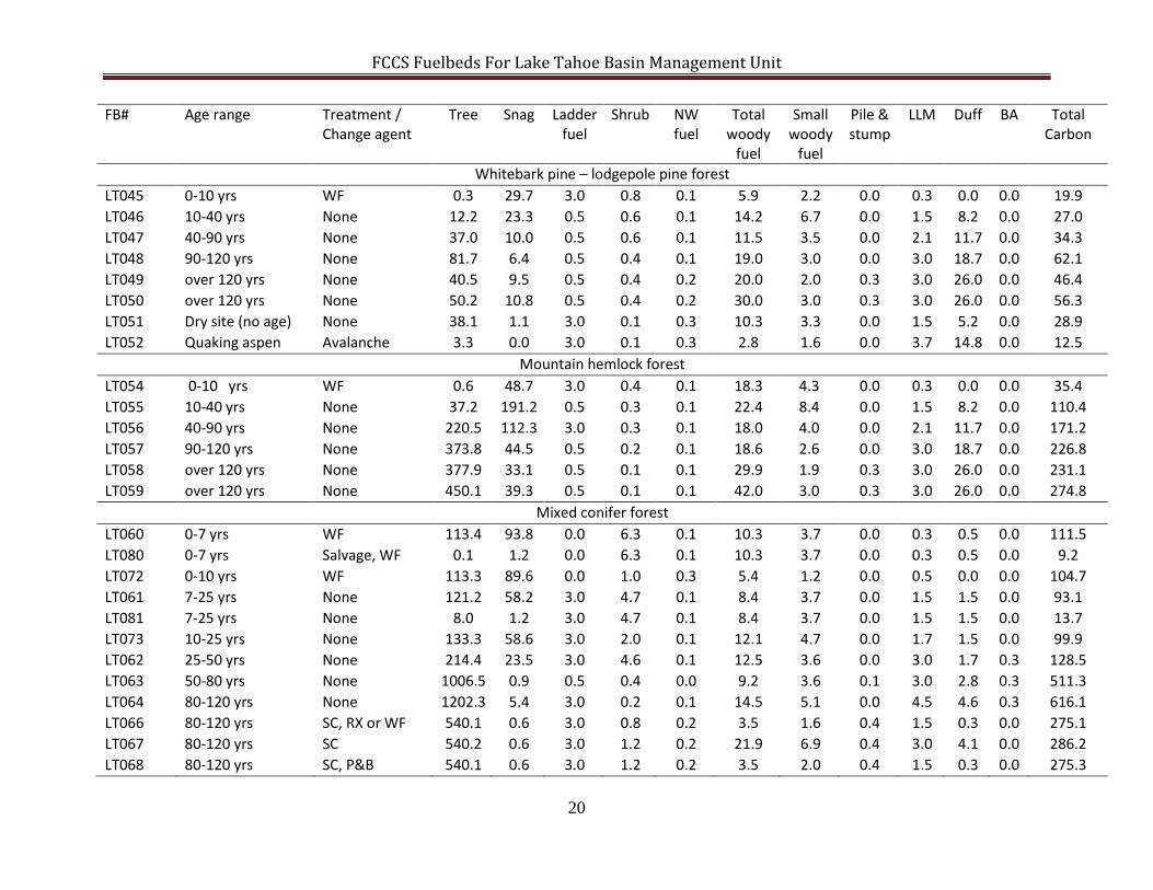
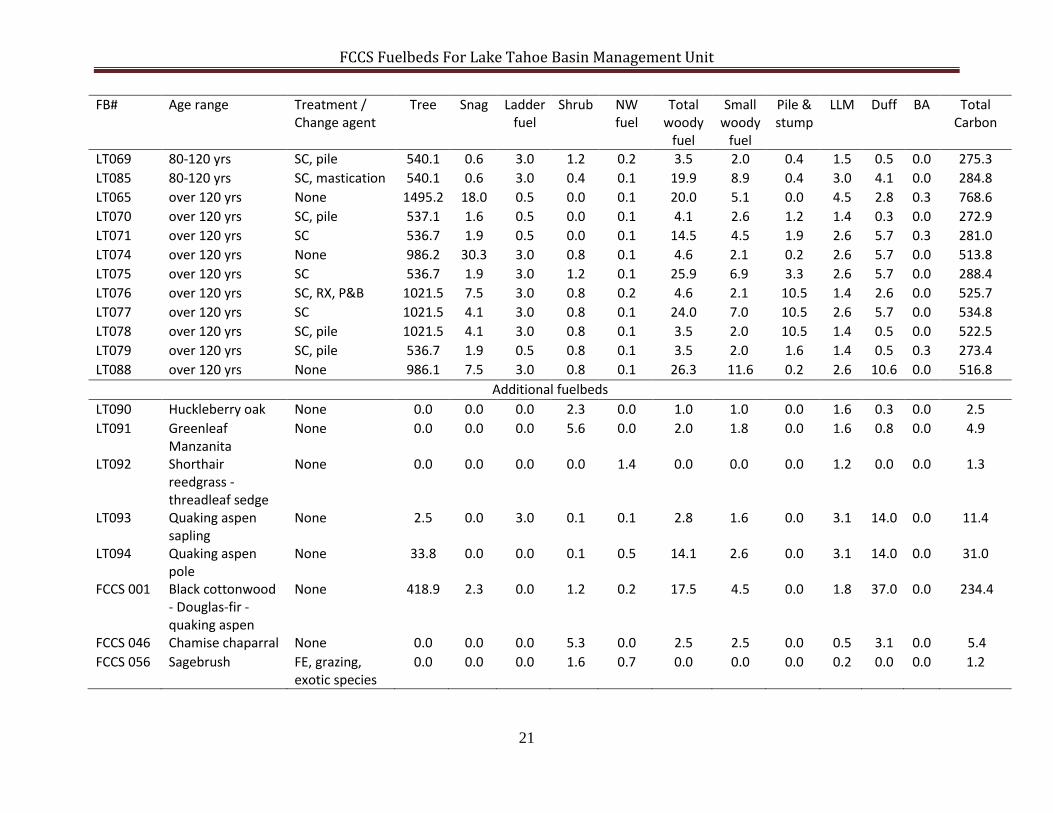
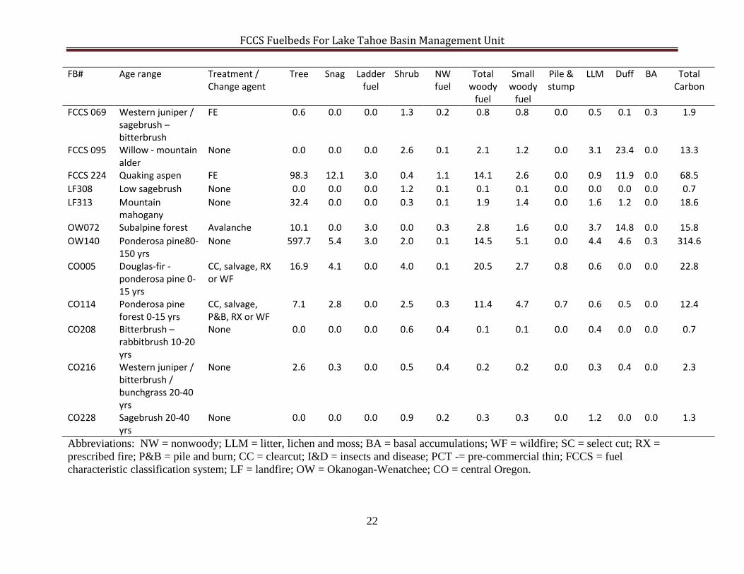
Table 1. Loading (tons/acre) for each major fuel category and total aboveground carbon (tons/acre) estimated for the Lake Tahoe
Basin Management Unit fuelbeds.
FB# Age range Treatment / Change agent
Tree Snag Ladder fuel
Shrub NW fuel
Total woody
fuel
Small woody
fuel
Pile & stump
LLM Duff BA Total Carbon
Jeffery pine – white fir forest LT001 0-7 years shrub WF 33.3 93.8 0.0 3.5 0.1 10.3 3.7 0.0 0.3 0.5 0.0 70.1 LT082 0-7 years shrub Salvage, WF 0.1 1.2 0.0 3.5 0.1 10.3 3.7 0.0 0.3 0.5 0.0 7.8 LT013 0-10 years grass WF 33.3 89.6 0.0 0.6 0.3 5.4 1.2 0.0 0.5 0.0 0.0 64.4 LT002 7-25 years None 36.9 6.9 3.0 1.7 0.1 8.4 3.7 0.0 1.5 1.5 0.0 28.9 LT083 7-25 years None 3.6 1.2 3.0 1.7 0.1 8.4 3.7 0.0 1.5 1.5 0.0 10.0 LT014 10-25 years None 42.3 6.9 3.0 1.5 0.1 12.1 4.7 0.0 2.1 1.5 0.0 33.6 LT003 25-50 years None 72.7 0.7 3.0 3.0 0.1 12.5 3.6 0.0 2.9 1.7 0.3 47.7 LT004 50-80 years None 385.1 0.9 0.5 2.7 0.0 9.2 3.6 0.1 3.0 2.8 0.3 201.7 LT005 80-120 years None 573.0 5.4 3.0 2.3 0.1 14.5 5.1 0.0 4.5 4.6 0.3 302.5 LT007 80-120 years SC, RX or WF 216.8 0.6 3.0 0.9 0.2 3.5 1.6 0.5 1.4 0.3 0.0 113.7 LT008 80-120 years SC 216.9 0.6 3.0 1.2 0.2 21.9 6.9 0.5 2.9 4.1 0.0 124.5 LT009 80-120 years SC, P&B 216.8 0.6 3.0 1.3 0.2 3.5 2.0 0.5 1.4 0.3 0.0 113.7 LT010 80-120 years SC, pile 216.8 0.6 3.0 1.2 0.2 3.5 2.0 0.5 1.5 0.5 0.0 113.7 LT084 80-120 years SC, mastication 216.8 0.6 3.0 0.4 0.1 19.9 8.9 0.5 2.9 4.1 0.0 123.2 LT006 over 120 years None 602.5 18.0 0.5 1.5 0.1 20.0 5.1 0.1 4.5 2.8 0.3 323.1 LT011 over 120 years SC, RX 109.8 1.9 0.5 1.5 0.1 4.1 2.6 1.0 1.3 0.3 0.3 60.1 LT012 over 120 years SC 109.8 1.9 0.5 1.5 0.1 14.5 4.5 1.6 2.4 5.7 0.3 68.1 LT015 over 120 years None 400.7 7.5 3.0 0.8 0.2 4.6 2.1 0.2 2.6 5.7 0.0 212.0 LT016 over 120 years SC 109.8 1.9 3.0 1.2 0.1 25.9 6.9 2.9 2.6 5.7 0.0 74.8 LT017 over 120 years SC, RX, P&B 345.5 7.5 3.0 0.9 0.2 4.6 2.1 8.8 1.4 2.6 0.0 186.9 LT018 over 120 years SC 345.5 4.1 3.0 0.8 0.1 24.0 7.0 8.8 2.6 5.7 0.0 196.0 LT019 over 120 years SC, pile 345.5 4.1 3.0 0.8 0.1 3.5 2.0 8.8 1.4 0.5 0.0 183.7 LT020 over 120 years SC, pile 109.8 1.9 0.5 2.3 0.1 3.5 2.0 1.6 1.3 0.5 0.3 60.6 LT087 over 120 years None 400.7 7.5 3.0 0.8 0.1 26.3 0.2 2.6 10.6 0.0 224.1
FCCS Fuelbeds For Lake Tahoe Basin Management Unit
19
FB# Age range Treatment / Change agent
Tree Snag Ladder fuel
Shrub NW fuel
Total woody
fuel
Small woody
fuel
Pile & stump
LLM Duff BA Total Carbon
Red fir forest LT021 0-10 years WF 14.2 123.3 0.0 2.5 0.0 17.1 3.3 0.0 1.4 3.1 0.0 78.1 LT022 10-25 years None 12.6 72.3 3.0 1.1 0.0 27.7 1.3 0.0 0.6 3.1 0.0 52.2 LT023 25-50 years None 41.6 28.8 0.5 0.1 0.0 25.7 6.1 0.0 3.0 8.9 0.0 49.9 LT024 50-80 years None 142.8 5.4 3.0 0.1 0.0 20.1 5.5 0.0 3.0 6.6 0.0 89.3 LT025 50-80 years PCT, P&B 38.7 1.3 0.5 0.4 0.1 5.4 2.9 0.6 1.2 1.7 0.0 24.7 LT026 50-80 years PCT, pile 38.7 1.3 0.5 0.4 0.1 35.0 10.0 0.6 6.6 22.0 0.0 49.6 LT027 80-120 years None 170.7 65.2 0.5 0.3 0.0 33.6 4.2 0.0 3.6 16.2 0.0 142.1 LT028 80-120 years SC, RX, P&B 51.0 1.3 0.5 0.3 0.0 3.8 0.8 1.0 0.6 0.9 0.0 29.3 LT029 80-120 years None 40.6 8.4 3.0 0.0 0.0 18.5 3.6 0.1 2.4 7.9 0.0 38.7 LT030 80-120 years None 82.7 10.5 0.5 0.1 0.0 40.0 10.0 0.1 6.9 28.9 0.0 86.8 LT031 80-120 years SC, pile 51.0 1.7 0.5 0.3 0.1 16.0 6.0 0.3 4.4 8.8 0.0 40.1 LT086 80-120 years SC, mastication 51.0 1.7 0.5 0.2 0.0 24.0 12.5 0.3 4.4 8.8 0.0 44.1 LT032 over 120 years None 139.2 28.4 0.5 0.2 0.0 48.0 8.0 0.0 7.5 35.6 0.0 124.4 LT033 over 120 years SC, RX, P&B 89.5 3.0 3.0 0.3 0.1 9.1 1.1 0.6 0.6 2.1 0.0 53.3 LT034 over 120 years SC, pile 89.5 3.0 3.0 0.3 0.0 16.5 6.5 0.9 3.0 8.8 0.0 60.9 LT035 over 120 years None 85.0 1.7 0.5 0.2 0.0 16.0 6.0 0.2 4.5 17.6 0.0 60.6 LT036 over 120 years None 85.0 5.0 0.5 0.3 0.1 16.0 6.0 0.2 7.5 7.7 0.0 59.8 LT089 over 120 years None 85.0 1.7 0.5 0.2 0.0 27.9 13.0 0.2 4.5 17.6 0.0 66.6
Lodgepole pine forest LT037 0-10 years WF 1.2 8.9 3.0 0.0 0.0 15.4 4.3 0.1 1.5 0.4 0.0 14.6 LT038 0-10 years CC, RX 1.2 0.4 3.0 0.0 0.0 4.5 0.7 1.2 1.5 0.4 0.0 6.1 LT039 10-20 years None 10.0 2.7 3.0 0.0 0.0 20.4 4.3 0.1 1.5 0.8 0.0 18.9 LT040 20-40 years None 15.6 1.4 3.0 0.0 0.0 19.7 3.2 0.1 2.1 2.6 0.0 21.7 LT041 20-40 years PCT 6.0 1.4 3.0 0.0 0.0 15.4 9.2 2.9 1.5 2.6 0.0 16.0 LT042 40-80 years None 60.3 20.3 3.0 0.0 0.0 21.6 3.2 0.1 0.0 5.3 0.0 54.6 LT043 40-80 years None 43.6 20.3 3.0 0.0 0.0 14.5 5.7 0.0 1.8 4.8 0.0 43.4 LT044 over 80 years I&D 59.6 36.3 3.0 0.0 0.0 49.2 3.2 0.1 3.0 8.6 0.0 77.7
FCCS Fuelbeds For Lake Tahoe Basin Management Unit
20
FB# Age range Treatment / Change agent
Tree Snag Ladder fuel
Shrub NW fuel
Total woody
fuel
Small woody
fuel
Pile & stump
LLM Duff BA Total Carbon
Whitebark pine – lodgepole pine forest LT045 0-10 yrs WF 0.3 29.7 3.0 0.8 0.1 5.9 2.2 0.0 0.3 0.0 0.0 19.9 LT046 10-40 yrs None 12.2 23.3 0.5 0.6 0.1 14.2 6.7 0.0 1.5 8.2 0.0 27.0 LT047 40-90 yrs None 37.0 10.0 0.5 0.6 0.1 11.5 3.5 0.0 2.1 11.7 0.0 34.3 LT048 90-120 yrs None 81.7 6.4 0.5 0.4 0.1 19.0 3.0 0.0 3.0 18.7 0.0 62.1 LT049 over 120 yrs None 40.5 9.5 0.5 0.4 0.2 20.0 2.0 0.3 3.0 26.0 0.0 46.4 LT050 over 120 yrs None 50.2 10.8 0.5 0.4 0.2 30.0 3.0 0.3 3.0 26.0 0.0 56.3 LT051 Dry site (no age) None 38.1 1.1 3.0 0.1 0.3 10.3 3.3 0.0 1.5 5.2 0.0 28.9 LT052 Quaking aspen Avalanche 3.3 0.0 3.0 0.1 0.3 2.8 1.6 0.0 3.7 14.8 0.0 12.5
Mountain hemlock forest LT054 0-10 yrs WF 0.6 48.7 3.0 0.4 0.1 18.3 4.3 0.0 0.3 0.0 0.0 35.4 LT055 10-40 yrs None 37.2 191.2 0.5 0.3 0.1 22.4 8.4 0.0 1.5 8.2 0.0 110.4 LT056 40-90 yrs None 220.5 112.3 3.0 0.3 0.1 18.0 4.0 0.0 2.1 11.7 0.0 171.2 LT057 90-120 yrs None 373.8 44.5 0.5 0.2 0.1 18.6 2.6 0.0 3.0 18.7 0.0 226.8 LT058 over 120 yrs None 377.9 33.1 0.5 0.1 0.1 29.9 1.9 0.3 3.0 26.0 0.0 231.1 LT059 over 120 yrs None 450.1 39.3 0.5 0.1 0.1 42.0 3.0 0.3 3.0 26.0 0.0 274.8
Mixed conifer forest LT060 0-7 yrs WF 113.4 93.8 0.0 6.3 0.1 10.3 3.7 0.0 0.3 0.5 0.0 111.5 LT080 0-7 yrs Salvage, WF 0.1 1.2 0.0 6.3 0.1 10.3 3.7 0.0 0.3 0.5 0.0 9.2 LT072 0-10 yrs WF 113.3 89.6 0.0 1.0 0.3 5.4 1.2 0.0 0.5 0.0 0.0 104.7 LT061 7-25 yrs None 121.2 58.2 3.0 4.7 0.1 8.4 3.7 0.0 1.5 1.5 0.0 93.1 LT081 7-25 yrs None 8.0 1.2 3.0 4.7 0.1 8.4 3.7 0.0 1.5 1.5 0.0 13.7 LT073 10-25 yrs None 133.3 58.6 3.0 2.0 0.1 12.1 4.7 0.0 1.7 1.5 0.0 99.9 LT062 25-50 yrs None 214.4 23.5 3.0 4.6 0.1 12.5 3.6 0.0 3.0 1.7 0.3 128.5 LT063 50-80 yrs None 1006.5 0.9 0.5 0.4 0.0 9.2 3.6 0.1 3.0 2.8 0.3 511.3 LT064 80-120 yrs None 1202.3 5.4 3.0 0.2 0.1 14.5 5.1 0.0 4.5 4.6 0.3 616.1 LT066 80-120 yrs SC, RX or WF 540.1 0.6 3.0 0.8 0.2 3.5 1.6 0.4 1.5 0.3 0.0 275.1 LT067 80-120 yrs SC 540.2 0.6 3.0 1.2 0.2 21.9 6.9 0.4 3.0 4.1 0.0 286.2 LT068 80-120 yrs SC, P&B 540.1 0.6 3.0 1.2 0.2 3.5 2.0 0.4 1.5 0.3 0.0 275.3
FCCS Fuelbeds For Lake Tahoe Basin Management Unit
21
FB# Age range Treatment / Change agent
Tree Snag Ladder fuel
Shrub NW fuel
Total woody
fuel
Small woody
fuel
Pile & stump
LLM Duff BA Total Carbon
LT069 80-120 yrs SC, pile 540.1 0.6 3.0 1.2 0.2 3.5 2.0 0.4 1.5 0.5 0.0 275.3 LT085 80-120 yrs SC, mastication 540.1 0.6 3.0 0.4 0.1 19.9 8.9 0.4 3.0 4.1 0.0 284.8 LT065 over 120 yrs None 1495.2 18.0 0.5 0.0 0.1 20.0 5.1 0.0 4.5 2.8 0.3 768.6 LT070 over 120 yrs SC, pile 537.1 1.6 0.5 0.0 0.1 4.1 2.6 1.2 1.4 0.3 0.0 272.9 LT071 over 120 yrs SC 536.7 1.9 0.5 0.0 0.1 14.5 4.5 1.9 2.6 5.7 0.3 281.0 LT074 over 120 yrs None 986.2 30.3 3.0 0.8 0.1 4.6 2.1 0.2 2.6 5.7 0.0 513.8 LT075 over 120 yrs SC 536.7 1.9 3.0 1.2 0.1 25.9 6.9 3.3 2.6 5.7 0.0 288.4 LT076 over 120 yrs SC, RX, P&B 1021.5 7.5 3.0 0.8 0.2 4.6 2.1 10.5 1.4 2.6 0.0 525.7 LT077 over 120 yrs SC 1021.5 4.1 3.0 0.8 0.1 24.0 7.0 10.5 2.6 5.7 0.0 534.8 LT078 over 120 yrs SC, pile 1021.5 4.1 3.0 0.8 0.1 3.5 2.0 10.5 1.4 0.5 0.0 522.5 LT079 over 120 yrs SC, pile 536.7 1.9 0.5 0.8 0.1 3.5 2.0 1.6 1.4 0.5 0.3 273.4 LT088 over 120 yrs None 986.1 7.5 3.0 0.8 0.1 26.3 11.6 0.2 2.6 10.6 0.0 516.8
Additional fuelbeds LT090 Huckleberry oak None 0.0 0.0 0.0 2.3 0.0 1.0 1.0 0.0 1.6 0.3 0.0 2.5 LT091 Greenleaf
Manzanita None 0.0 0.0 0.0 5.6 0.0 2.0 1.8 0.0 1.6 0.8 0.0 4.9
LT092 Shorthair reedgrass - threadleaf sedge
None 0.0 0.0 0.0 0.0 1.4 0.0 0.0 0.0 1.2 0.0 0.0 1.3
LT093 Quaking aspen sapling
None 2.5 0.0 3.0 0.1 0.1 2.8 1.6 0.0 3.1 14.0 0.0 11.4
LT094 Quaking aspen pole
None 33.8 0.0 0.0 0.1 0.5 14.1 2.6 0.0 3.1 14.0 0.0 31.0
FCCS 001 Black cottonwood - Douglas-fir - quaking aspen
None 418.9 2.3 0.0 1.2 0.2 17.5 4.5 0.0 1.8 37.0 0.0 234.4
FCCS 046 Chamise chaparral None 0.0 0.0 0.0 5.3 0.0 2.5 2.5 0.0 0.5 3.1 0.0 5.4 FCCS 056 Sagebrush FE, grazing,
exotic species 0.0 0.0 0.0 1.6 0.7 0.0 0.0 0.0 0.2 0.0 0.0 1.2
FCCS Fuelbeds For Lake Tahoe Basin Management Unit
22
FB# Age range Treatment / Change agent
Tree Snag Ladder fuel
Shrub NW fuel
Total woody
fuel
Small woody
fuel
Pile & stump
LLM Duff BA Total Carbon
FCCS 069 Western juniper / sagebrush – bitterbrush
FE 0.6 0.0 0.0 1.3 0.2 0.8 0.8 0.0 0.5 0.1 0.3 1.9
FCCS 095 Willow - mountain alder
None 0.0 0.0 0.0 2.6 0.1 2.1 1.2 0.0 3.1 23.4 0.0 13.3
FCCS 224 Quaking aspen FE 98.3 12.1 3.0 0.4 1.1 14.1 2.6 0.0 0.9 11.9 0.0 68.5 LF308 Low sagebrush None 0.0 0.0 0.0 1.2 0.1 0.1 0.1 0.0 0.0 0.0 0.0 0.7 LF313 Mountain
mahogany None 32.4 0.0 0.0 0.3 0.1 1.9 1.4 0.0 1.6 1.2 0.0 18.6
OW072 Subalpine forest Avalanche 10.1 0.0 3.0 0.0 0.3 2.8 1.6 0.0 3.7 14.8 0.0 15.8 OW140 Ponderosa pine80-
150 yrs None 597.7 5.4 3.0 2.0 0.1 14.5 5.1 0.0 4.4 4.6 0.3 314.6
CO005 Douglas-fir - ponderosa pine 0-15 yrs
CC, salvage, RX or WF
16.9 4.1 0.0 4.0 0.1 20.5 2.7 0.8 0.6 0.0 0.0 22.8
CO114 Ponderosa pine forest 0-15 yrs
CC, salvage, P&B, RX or WF
7.1 2.8 0.0 2.5 0.3 11.4 4.7 0.7 0.6 0.5 0.0 12.4
CO208 Bitterbrush – rabbitbrush 10-20 yrs
None 0.0 0.0 0.0 0.6 0.4 0.1 0.1 0.0 0.4 0.0 0.0 0.7
CO216 Western juniper / bitterbrush / bunchgrass 20-40 yrs
None 2.6 0.3 0.0 0.5 0.4 0.2 0.2 0.0 0.3 0.4 0.0 2.3
CO228 Sagebrush 20-40 yrs
None 0.0 0.0 0.0 0.9 0.2 0.3 0.3 0.0 1.2 0.0 0.0 1.3
Abbreviations: NW = nonwoody; LLM = litter, lichen and moss; BA = basal accumulations; WF = wildfire; SC = select cut; RX =
prescribed fire; P&B = pile and burn; CC = clearcut; I&D = insects and disease; PCT -= pre-commercial thin; FCCS = fuel
characteristic classification system; LF = landfire; OW = Okanogan-Wenatchee; CO = central Oregon.
FCCS Fuelbeds For Lake Tahoe Basin Management Unit
23
Appendix 2
FCCS Fuelbeds For Lake Tahoe Basin Management Unit
24
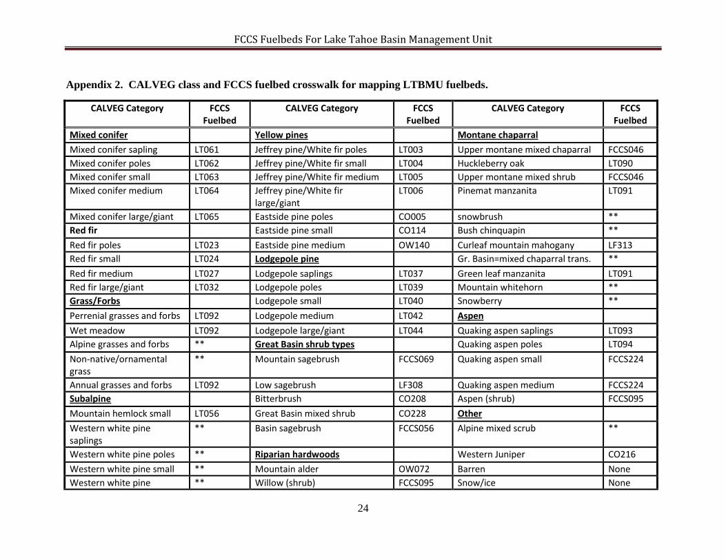
Appendix 2. CALVEG class and FCCS fuelbed crosswalk for mapping LTBMU fuelbeds.
CALVEG Category FCCS Fuelbed
CALVEG Category FCCS Fuelbed
CALVEG Category FCCS Fuelbed
Mixed conifer Yellow pines Montane chaparral
Mixed conifer sapling LT061 Jeffrey pine/White fir poles LT003 Upper montane mixed chaparral FCCS046 Mixed conifer poles LT062 Jeffrey pine/White fir small LT004 Huckleberry oak LT090 Mixed conifer small LT063 Jeffrey pine/White fir medium LT005 Upper montane mixed shrub FCCS046 Mixed conifer medium LT064 Jeffrey pine/White fir
large/giant LT006 Pinemat manzanita LT091
Mixed conifer large/giant LT065 Eastside pine poles CO005 snowbrush ** Red fir Eastside pine small CO114 Bush chinquapin **
Red fir poles LT023 Eastside pine medium OW140 Curleaf mountain mahogany LF313 Red fir small LT024 Lodgepole pine Gr. Basin=mixed chaparral trans. **
Red fir medium LT027 Lodgepole saplings LT037 Green leaf manzanita LT091 Red fir large/giant LT032 Lodgepole poles LT039 Mountain whitehorn ** Grass/Forbs Lodgepole small LT040 Snowberry **
Perrenial grasses and forbs LT092 Lodgepole medium LT042 Aspen
Wet meadow LT092 Lodgepole large/giant LT044 Quaking aspen saplings LT093 Alpine grasses and forbs ** Great Basin shrub types Quaking aspen poles LT094
Non-native/ornamental grass
** Mountain sagebrush FCCS069 Quaking aspen small FCCS224
Annual grasses and forbs LT092 Low sagebrush LF308 Quaking aspen medium FCCS224 Subalpine Bitterbrush CO208 Aspen (shrub) FCCS095
Mountain hemlock small LT056 Great Basin mixed shrub CO228 Other Western white pine saplings
** Basin sagebrush FCCS056 Alpine mixed scrub **
Western white pine poles ** Riparian hardwoods Western Juniper CO216
Western white pine small ** Mountain alder OW072 Barren None Western white pine ** Willow (shrub) FCCS095 Snow/ice None
FCCS Fuelbeds For Lake Tahoe Basin Management Unit
25
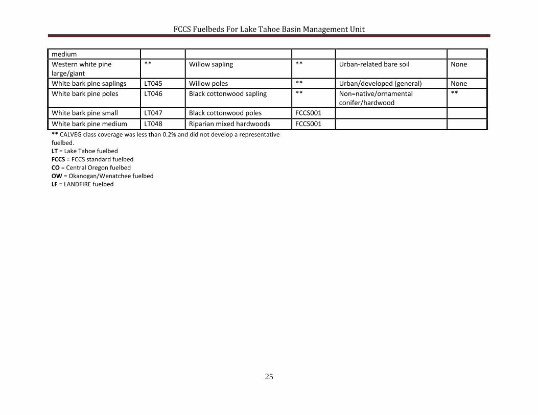
medium Western white pine large/giant
** Willow sapling ** Urban-related bare soil None
White bark pine saplings LT045 Willow poles ** Urban/developed (general) None White bark pine poles LT046 Black cottonwood sapling ** Non=native/ornamental
conifer/hardwood **
White bark pine small LT047 Black cottonwood poles FCCS001 White bark pine medium LT048 Riparian mixed hardwoods FCCS001 ** CALVEG class coverage was less than 0.2% and did not develop a representative fuelbed. LT = Lake Tahoe fuelbed FCCS = FCCS standard fuelbed CO = Central Oregon fuelbed OW = Okanogan/Wenatchee fuelbed LF = LANDFIRE fuelbed
FCCS Fuelbeds For Lake Tahoe Basin Management Unit
26

![Ms. Zora Elizabeth [Miller] - Sprouse - Roby. Perhaps ...hansandcassady.org/FCCS-Erin-Morgan-PDF.pdf · the "Executive Director" - of FCCS - and you. 1) My biological mother was:](https://img.pdfslide.us/doc/110x75/5e917b23378e9a25a4429c48/ms-zora-elizabeth-miller-sprouse-roby-perhaps-the-executive-director.jpg)